Dr. Douglas Patchen WVU Energy Institute s NRCCE Director, Appalachian Region for PTTC PSU Extension Webinar January 18, 2018
|
|
|
- Fay Charity Hensley
- 5 years ago
- Views:
Transcription
1 GEOLOGIC OPTIONS FOR SUBSURFACE STORAGE OF UTICA MARCELLUS NGLS Dr. Douglas Patchen WVU Energy Institute s NRCCE Director, Appalachian Region for PTTC PSU Extension Webinar January 18, 2018
2 DISTRIBUTION OF HYDROCARBON PRODUCTION FROM APPALACHIAN SHALES Utica & Marcellus yield oil, wet gas, dry gas Distribution is a function of thermal maturity Places oil up dip from wet gas and dry gas In conventional plays, oil is down dip from gas 2

3 Modified from Trenton and Black River Playbook, 2008
4 Source: R.T. Ryder, USGS OFR

5 UTICA & MARCELLUS PRODUCTION TRENDS 5
6 BACKGROUND Liquid-rich Marcellus and Utica Shale production in the tri-state area of OH, PA and WV Desire to move natural gas liquids (NGLs) from wet gas areas to petrochemical sites throughout the greater Appalachian region A proposed 6-pack pipeline from Monaca, PA to northeastern KY and Charleston, WV along the Ohio & Kanawha rivers Subsurface storage will be a necessary component along the pipeline route; created a need for the study
7 AONGRC SELECTED FOR THE STUDY Evaluate the storage potential of subsurface rocks along the pipeline route from SW PA to NE KY and SW WV This defined the Area of Interest (AOI) Study period: 1 year (August 1, 2016 July 31, 2017)
8 RESEARCH TEAM MEMBERS Ohio Geological Survey Pennsylvania Geological Survey West Virginia Geological Survey WVU Energy Institute s National Research Center for Coal & Energy
9 FUNDING SOURCES The Claude Worthington Benedum Foundation provided 50% of the funds; our thanks to them Matching funds provided by Industry partners AEP, Antero Resources, Blue Racer, Charleston Area Alliance, Chevron, Dominion, EQT, First Energy/Team NEO, Mountaineer NGL Storage LLC, Noble Energy, Southwestern Energy, XTO Energy, WVONGA Additional cost share (30%)from the Research Team Members

10 STUDY GOAL Complete a geologic study of all potential options for subsurface storage of NGLs along and adjacent to the Ohio River from southwestern Pennsylvania to eastern Kentucky, including a similar study along the Kanawha River in West Virginia Stratigraphic correlation of key units Mapping thickness and structure of key units Reservoir characterization studies Development and application of rating and ranking criteria Area of Interest (AOI)
11 TODAY S CONTENT This was a TECHNICAL STUDY, and what you will hear will be the TECHNICAL RESULTS of the Study; nothing on business or economics I will briefly summarize the various portions of the Study that eventually led us to our conclusions & recommendations The final report can be found at
12 RESEARCH PLAN Compile a regional data base; legacy & new data Conduct a regional subsurface stratigraphic study Identify potential candidates for storage containers Characterize the Potential Reservoirs (3 types) Develop Criteria with which to Rate & Ultimately Rank Candidates (distance, thickness, depth, etc) Continue to Drill Down from the Regional to the Prospect Level to characterization of a reservoir
13 PART 1: THE STUDY DATABASE Legacy sources & data derived specifically for this work, have been organized and assimilated into the Study website Raw datasets, analyses and derived data utilized by the Research Team to complete the Study The rating and ranking methodologies specifically developed by the Research Team to evaluate subsurface storage prospects in the Study area The final report, with subsurface geology and reservoir characterization findings, storage recommendations, and tables, figures and appendices
14 PART 2: REGIONAL STRATIGRAPHIC STUDY Why? Get all 3 Surveys on the same page Consistent picks for all stratigraphic units on well logs Correlate the units on cross sections across state lines Map the thickness and extent, including thicker units Identify thin reservoirs within the thicker intervals Interpretations based on available information Allows you to know what to expect beneath your property
15 GEOLOGIC INTERVALS OF INTEREST Mined-rock caverns Greenbrier Limestone (>40 ft thick; depths of 1, ft) Solution-mined caverns Salina Group salts (>100 thick) Gas Reservoirs Keener sandstone to Berea Sandstone Upper Devonian sandstones (Venango, Bradford, Elk) Oriskany Sandstone Newburg sandstone Clinton-Medina Group through Tuscarora Sandstone Rose Run and Upper Sandy Member of the Gatesburg Formation


16 16 REGIONAL STRATIGRAPHIC CORRELATION 10 geologic intervals (red) Lateral variations in lithology, facies and nomenclature Variations in depth and thickness of units based on depositional environment and post-depositional processes Thousands of pieces of data used to correlate lithostratigraphy throughout the AOI


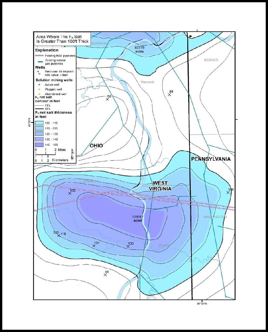
17 DEVONIAN SILURIAN AGE ROCKS S N N S Oriskany Sandstone is bound by unconformities on both top and base in the western portion of the AOI. The Salina salt basin is centered along West Virginia panhandle. Salina F4 salt is ~100 ft thick in this area of the AOI. Newburg sandstone is equivalent to the Salina C and developed in southwestern West Virginia. Clinton/Medina Group is present throughout the AOI. 17

 Study")

18 18 Appalachian Storage Hub (ASH) Study Appalachian Storage Hub (ASH) Study
")

19 Appalachian Storage Hub (ASH) Study Appalachian Storage Hub (ASH) Study 29
")

20 17 Appalachian Storage Hub (ASH) Study Appalachian Storage Hub (ASH) Study
21 PART 3: DETERMINING KEY CRITERIA FOR THE THREE OPTIONS FOR NGL STORAGE Mined-rock caverns (carbonate rock) Solution-mined caverns (bedded salt) Depleted gas fields(siliciclastic units, mainly sandstones) 21
22 OPTION#1: MINED-ROCK CAVERNS - GREENBRIER LIMESTONE Essentially, not all limestones are the same They differ in grain size, pore space, etc. due to variations in where and how they were deposited Our goal was to find the best type of limestone for storage lithology is important! A mined-rock cavern needs a good seal, so overlying/underlying unit properties are also important 22
23 GREENBRIER LIMESTONE (MINED- ROCK CAVERNS) Prepare regional structure and isopach contour maps Optimum net thicknesses 40 ft Optimum depths 1,800 2,000 ft


24 Wynn, 2003 Wynn, 2003
25 2 GREENBRIER LIMESTONE THREE FACIES Appalachian Storage Hub (ASH) Study Appalachian Storage Hub (ASH) Study Appalachian Storage Hub (ASH) Study Figure 7. Net thickness map of the Greenbrier lime mudstone facies package.
26 OPTION 2: SOLUTION CAVITIES IN SALINA SALT Salt itself is the sealing mechanism for this container Therefore, we need thick intervals of pure salt Need a large area to create the cavity away from the edge of the salt Thickness, purity, extent are key factors
, punctuated by thin anhydrite and")
 separated from F4 Salt by anhydrite/dolomite")
27 SALINA F4 SALT Interval comprised of relatively thick salt (salmon), punctuated by thin anhydrite and dolomite zones (light blue) Underlying salt bed (light pink) separated from F4 Salt by anhydrite/dolomite (light blue) 27
28
29 OPTION #3: DEPLETED GAS FIELDS - SANDSTONE RESERVOIRS Drilling down really applies here Began with >2,700 reservoirs/fields in the AOI, ~1,500 of which occurred at depths of 2,000 ft or more Preliminary screening of the 1,500 fields yielded 125 fields Detailed rating efforts yielded 30 fields/areas Preferred field will have good thickness, porosity, permeability, areal extent, seals (upper, lower and lateral) and be close to pipeline infrastructure Dry holes or wells with salt water facilitate delineation of container extents 29
30 PART 4: RATING CRITERIA & FINAL RANKING PROCEDURE Needed to determine the most critical parameters to be used to score a field Different criteria for the three types of containers were used for rating purposes Ultimately, those criteria common to all three types of containers were used to rank candidates
31 DETAILED RATING CRITERIA Mined-Rock Caverns Salt Caverns Depleted Gas Reservoirs Gas Storage Fields Distance to Infrastructure Distance to Infrastructure Distance to Infrastructure Distance to Infrastructure Acreage Acreage Acreage Acreage Average depth Average depth Average depth Average depth Net Thickness Net Thickness Net Thickness Net Thickness Trap integrity Trap integrity Trap integrity Trap integrity Legacy well penetrations Legacy well penetrations Legacy well penetrations Legacy well penetrations Stacked opportunity Stacked opportunity Stacked opportunity Stacked opportunity Pressure Pressure Pressure Average Porosity Average Porosity Permeability Permeability Mode CO 2 storage Estimated cumulative gas production Mode CO 2 storage Working gas capacity
32 PRELIMINARY ASSESSMENT OF DEPLETED GAS RESERVOIRS Preliminary rating criteria Distance to infrastructure Acreage Average depth Average porosity Net thickness Permeability Pressure Distance to infrastructure >30 mi >20 mi but <=30 mi >5 mi but <=20 mi <=5 mi Acreage <=500 ac >500 ac but <=1,000 ac >1,000 ac but <=5,000 ac >5,000 ac Stacked opportunity Mode CO 2 storage Criterion Description Range of Values Proximity of field to any of the existing or proposed pipeline infrastructure,as illustrated in Figure 4-26 Measured size (or footprint ) of a field (ac) Average depth <=2,000 ft >5,000 ft >3,500 ft but <=5,000ft >2,000 ft but <=3,500ft Average depth (ft) at which a field stores/stored natural gas, based on multiple wells completed in that field

33 RESULTS OF PRELIMINARY ASSESSMENT 113 depleted gas fields 12 natural gas storage fields 5 limestone areas 4 salt areas
34 NORMALIZED DATA FOR FINAL RATING AND RANKING EFFORT Mined-Rock Caverns Salt Caverns Depleted Gas Reservoirs Gas Storage Fields Distance to Infrastructure Distance to Infrastructure Distance to Infrastructure Distance to Infrastructure Acreage Acreage Acreage Acreage Average depth Average depth Average depth Average depth Net Thickness Net Thickness Net Thickness Net Thickness Trap integrity Trap integrity Trap integrity Trap integrity Legacy well penetrations Legacy well penetrations Legacy well penetrations Legacy well penetrations Stacked opportunity Stacked opportunity Stacked opportunity Stacked opportunity
35 FINAL RANKING RESULTS Ranking Container Normalized Field/Location Geologic Interval Type Rating 1 mined-rock cavern 5 Greenbrier 19 2 depleted gas NORTH RIPLEY Newburg 16 reservoir 2 depleted gas ROCKY FORK Newburg 16 reservoir 2 depleted gas KANAWHA FOREST Newburg 16 reservoir 2 mined-rock cavern 4 Greenbrier 16 3 depleted gas CAMPBELL CREEK Oriskany 15 reservoir 3 mined-rock cavern 2 Greenbrier 15 3 salt cavern 1 Salina F4 Salt 15 3 salt cavern 2 Salina F4 Salt 15 Ranking Container Type Field/Location Geologic Interval Normalized Rating 1 mined-rock cavern 5 Greenbrier 19 2 depleted gas reservoir NORTH RIPLEY Newburg 16 2 depletedgas reservoir ROCKY FORK Newburg 16 2 depletedgas reservoir KANAWHA FOREST Newburg 16 2 mined-rock cavern 4 Greenbrier 16 3 depletedgas reservoir CAMPBELL CREEK Oriskany 15 3 mined-rock cavern 2 Greenbrier saltcavern saltcavern 1 2 Salina F4 Salt Salina F4 Salt depletedgas reservoir WESTON-JANE LEW Elk depletedgas reservoir depletedgas reservoir CANTON CONSOLIDATED Clinton/Medina 14 COOPER CREEK Newburg 14 4 depletedgas reservoir ABBOTT-FRENCH CREEK Venango 14 4 natural gas storage field RIPLEY Oriskany 14 5 depletedgas reservoir MAPLE-WADESTOWN Keener to Berea 13 5 depletedgas reservoir ELK-POCA (SISSONVILLE) Oriskany 13 5 gas storage field RACKET-NEWBERNE (SINKING CREEK) Venango 13 5 saltcavern 4 Salina F4 salt 13 4 depletedgas reservoir CANTON CONSOLIDATED Clinton/Medina 13 5 depletedgas reservoir CANTON CONSOLIDATED Clinton/Medina depletedgas reservoir depletedgas reservoir RAVENNA-BEST CONSOLIDATED Clinton/Medina 13 BURDETT-ST. ALBANS Keener to Berea 12 depleted gas reservoir CONDIT-RAGTOWN Keener to Berea 12 depletedgas reservoir depletedgas reservoir depletedgas reservoir depletedgas reservoir depletedgas reservoir depletedgas reservoir depletedgas reservoir DUMM RIDGE FRAZEYBURG KIRKERSVILLE DUMM RIDGE DUMM RIDGE ROCKBRIDGE RANDOLPH Rose Run- Gatesburg Rose Run- Gatesburg Rose Run- Gatesburg Rose Run- Gatesburg Rose Run- Gatesburg Rose Run- Gatesburg Rose Run- Gatesburg

36 36 DETAILED RATING RESULTS 30 opportunities 22 depleted gas fields 3 salt areas 3 mined-rock areas 2 natural gas storage fields

37 PART 5: THREE PROSPECT AREAS Greenbrier Lime Mudstone Isopach Each prospect differs in number and type of opportunities Demonstrate how this Study s geologic data can be applied in underground storage siting work Stacked storage is a key factor Again, the goal is to give you an idea of what you might expect below your property 37
38 3 NORTHERN PROSPECT Oriskany Sandstone Greenbrier Lime Mudstone Isopach Salina F4 Salt (salt cavern) Clinton/Medina Group (depleted gas field)

39 STACKED STORAGE NORTH PROSPECT Figure 5-3. Cartoon of the subsurface geology associated with the Northern Prospect, which has three storage opportunities (not to scale).


40 4 SALINA F4 SALT Area 1 Area 2

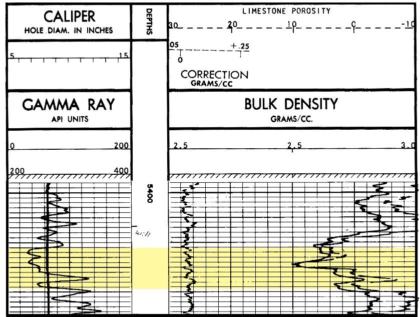
41 41 SALINA F4 SALT Area 2 Cross Section F4 Salt Salt Interbeds
42 42 CENTRAL PROSPECT Greenbrier Limestone (mined-rock cavern) Greenbrier Lime Mudstone Isopach Keener to Berea Interval (depleted gas fields) Upper Devonian Venango Group (natural gas storage field) Upper Devonian Elk Group (depleted gas field) Salina F4 Salt (salt cavern)

43 43 CENTRAL PROSPECT AREA Greenbrier Limestone mines throughout the area; key facies, thickness and depth Keener to Berea Interval depleted gas field Venango Group inactive gas storage field Upper Devonian depleted gas field to the east Salina F4 Salt near Ben s Run

44 44 GREENBRIER LIMESTONE Isopach Optimal depth and thickness Large footprint Greenbrier Lime Mudstone Isopach Stacked opportunity Close to infrastructure Poor trap integrity Poor penetration rating


45 SALINA F4 SALT F4 Salt Salt Interbeds Area 4 Cross Section 45
46 SOUTHERN PROSPECT Greenbrier Limestone (mined-rock caverns) Greenbrier Lime Mudstone Isopach Keener to Berea Interval (depleted gas field) Oriskany Sandstone (depleted gas and natural gas storage fields) Newburg sandstone (depleted gas fields) 46
 are among the very best of all depleted gas")
47 47 SOUTHERN PROSPECT AREA Greenbrier Limestone mined-rock storage Depleted gas fields in the Keener to Berea Interval Oriskany gas storage in part of Elk-Poca field Newburg fields(north Ripley, Rocky Fork, Cooper Creek and Kanawha Forest) are among the very best of all depleted gas fields
")

48 ORISKANY SANDSTONE (DEPLETED GAS FIELDS) Elk-Poca (Sissonville) Field Campbell Creek Field 48
49 ORISKANY SANDSTONE (DEPLETED GAS FIELDS) ELK-POCA (SISSONVILLE) FIELD 4,140 5,497 ft measured depth ~2,200 psi reservoir pressure 18 ft net thickness ~4% 15% porosity CAMPBELL CREEK FIELD 4,825 ft average measured depth 2,100 psi reservoir pressure 15 ft net thickness 9% porosity 49

50 NEWBURG SANDSTONE
51 NEWBURG SANDSTONE FIELDS Field Average producing depth (ft) Net thickness (ft) Average pay thickness (ft)* Pressure (psi) Porosity (%) Permeability (md)* Initial pressure (psi) Trap type North Ripley 5, , ,329 Rocky Fork 5, , ,435 Cooper Creek 5, , ,491 Stratigraphic/ Structural Stratigraphic/ Structural Stratigraphic/ Structural Kanawha Forest 5, , ,329 Structural *from Patchen (1996)
52 PROSPECT SUMMARY Presented three prospects along the Ohio River Valley corridor Provided an example of how end users may apply the regional and field-level data prepared for this Study in their own underground storage potential Demonstrated the importance of stacked opportunities
53 WHAT WE DID NOT CONSIDER Who owns or operates a depleted gas field or gas storage field that was rated highly Or if this operator would be interested in NGL storage Who owns the rights to the Greenbrier Limestone or Salina Salt And again, if the owner might be interested in NGL storage If a candidate is in an area of future Marcellus or Utica drilling Surficial activities, other than towns or cities Cost implications for storage and pipelines Focus was entirely on subsurface geology
54 SUMMARY AND CAVIATS Multiple options are present along the Ohio and Kanawha rivers where storage could be constructed in three different types of storage containers Storage capacity and deliverability will ultimately depend on the NGL product(s) Storage capacity and deliverability may require more than one facility and/or more than one geologic container per facility (stacked storage) We recommend a follow-on engineering and geologic site assessment at any potential site

55 ACKNOWLEDGEMENTS AONGRC co-authors and contributors Kristin Carter, Jessica Moore, Mohammad Fakhari, Gary Daft, Michael Solis, Brian Dunst, Robin Anthony, Katherine Schmid, Kyle Metz, Philip Dinterman, Julie Bloxson, Erica Schubert, John Saucer, Antonette Markowski, Stephen Shank, Michael Hohn, John Bocan, Michael Angle and various interns Benedum Foundation Industry Partners AEP, Antero Resources, Blue Racer, Charleston Area Alliance, Chevron, Dominion, EQT, First Energy/Team NEO, Mountaineer NGL Storage LLC, Noble Energy, Southwestern Energy, XTO Energy and the West Virginia Oil & Natural Gas Association West Virginia University WVU Foundation, WVU Research Corporation, National Research Center for Coal and Energy and WVU Corporate Relations Office Advisory Group
GEOLOGIC FINDINGS OF THE BENEDUM FOUNDATION S APPALACHIAN STORAGE HUB STUDY
 1 GEOLOGIC FINDINGS OF THE BENEDUM FOUNDATION S APPALACHIAN STORAGE HUB STUDY Kristin M. Carter, P.G., C.P.G. Assistant State Geologist Pennsylvania Geological Survey (Pittsburgh, PA) krcarter@pa.gov ACKNOWLEDGEMENTS
Evaluating Suitability of Appalachian Basin Reservoirs for NGLs Storage Jessica Moore, West Virginia Geological & Economic Survey
 1 THE APPALACHIAN STORAGE HUB STUDY: Evaluating Suitability of Appalachian Basin Reservoirs for NGLs Storage Jessica Moore, West Virginia Geological & Economic Survey 2 ASH STUDY OUR GOAL Complete a geologic
MAPPING AND RESERVOIR CHARACTERIZATION OF GEOLOGIC INTERVALS FOR NGL STORAGE APPLICATIONS
 MAPPING AND RESERVOIR CHARACTERIZATION OF GEOLOGIC INTERVALS FOR NGL STORAGE APPLICATIONS Robin V. Anthony 1, Doug Patchen 2, Jessica Moore 3, Michael Solis 4 1 PA DCNR, Bureau of Topographic & Geologic
A GEOLOGIC STUDY TO DETERMINE THE POTENTIAL TO CREATE AN APPALACHIAN STORAGE HUB FOR NATURAL GAS LIQUIDS FINAL REPORT
 A GEOLOGIC STUDY TO DETERMINE THE POTENTIAL TO CREATE AN APPALACHIAN STORAGE HUB FOR NATURAL GAS LIQUIDS FINAL REPORT Project Start Date: August 1, 2016 Project End Date: July 31, 2017 APPALACHIAN OIL
APPALACHIAN STORAGE HUB (ASH) PROJECT. Semi-Annual Meeting March 14, 2017 WVU Erickson Alumni Center
 PROJECT. Semi-Annual Meeting March 14, 2017 WVU Erickson Alumni Center") APPALACHIAN STORAGE HUB (ASH) PROJECT Semi-Annual Meeting March 14, 2017 WVU Erickson Alumni Center STRATEGY 2: STRATIGRAPHIC CORRELATION Kyle Metz Energy Resources Group, Ohio Department of Natural Resources
APPALACHIAN STORAGE HUB (ASH) PROJECT Semi-Annual Meeting March 14, 2017 WVU Erickson Alumni Center STRATEGY 2: STRATIGRAPHIC CORRELATION Kyle Metz Energy Resources Group, Ohio Department of Natural Resources
APPALACHIAN STORAGE HUB (ASH) FOR LIQUID ETHANE. QUARTERLY REPORT August 2016 October Submitted By
 FOR LIQUID ETHANE. QUARTERLY REPORT August 2016 October Submitted By") APPALACHIAN STORAGE HUB (ASH) FOR LIQUID ETHANE QUARTERLY REPORT August 2016 October 2016 Submitted By APPALACHIAN OIL & NATURAL GAS RESEARCH CONSORTIUM National Research Center for Coal & Energy Ohio
APPALACHIAN STORAGE HUB (ASH) FOR LIQUID ETHANE QUARTERLY REPORT August 2016 October 2016 Submitted By APPALACHIAN OIL & NATURAL GAS RESEARCH CONSORTIUM National Research Center for Coal & Energy Ohio
APPALACHIAN STORAGE HUB (ASH) FOR LIQUID ETHANE. QUARTERLY REPORT November 2016 January Submitted By
 FOR LIQUID ETHANE. QUARTERLY REPORT November 2016 January Submitted By") APPALACHIAN STORAGE HUB (ASH) FOR LIQUID ETHANE QUARTERLY REPORT November 2016 January 2017 Submitted By APPALACHIAN OIL & NATURAL GAS RESEARCH CONSORTIUM National Research Center for Coal & Energy Ohio
APPALACHIAN STORAGE HUB (ASH) FOR LIQUID ETHANE QUARTERLY REPORT November 2016 January 2017 Submitted By APPALACHIAN OIL & NATURAL GAS RESEARCH CONSORTIUM National Research Center for Coal & Energy Ohio
Mapping and Reservoir Characterization of Geologic Intervals for NGL Storage Applications*
 Mapping and Reservoir Characterization of Geologic Intervals for NGL Storage Applications* Kristin Carter 1, Douglas Patchen 2, Jessica Moore 3, Mohammad Fakhari 4, Gary Daft 3, Phillip Dinterman 3, Michael
OVERVIEW OF THE ROGERSVILLE SHALE IN WEST VIRGINIA. Philip Dinterman West Virginia Geological & Economic Survey May 11, 2017
 OVERVIEW OF THE ROGERSVILLE SHALE IN WEST VIRGINIA Philip Dinterman West Virginia Geological & Economic Survey May 11, 2017 ACKNOWLEDGEMENT Dave Harris, John Hickman, Kentucky Geological Survey DATA NOTE
MRCSP Geologic Field Tests
 Power Plant Depth (ft bgs) 0 Injection Test Well 1,000 2,000 3,000 4,000 5,000 6,000 7,000 8,000 Storage Formation 9,000 10,000 11,000 12,000 13,000 MRCSP R.E. Burger Site Geologic Field Tests in the Appalachian
Bulletin of Earth Sciences of Thailand. Evaluation of the Petroleum Systems in the Lanta-Similan Area, Northern Pattani Basin, Gulf of Thailand
 Evaluation of the Petroleum Systems in the Lanta-Similan Area, Northern Pattani Basin, Gulf of Thailand Sirajum Munira Petroleum Geoscience Program, Department of Geology, Faculty of Science, Chulalongkorn
GEOLOGY, RESOURCES, AND POTENTIAL ACTIVITY LEVELS
 GEOLOGY, RESOURCES, AND POTENTIAL ACTIVITY LEVELS NAS Workshop on the Development of Unconventional Hydrocarbon Resources in the Appalachian Basin Ray Boswell, US DOE/NETL Morgantown, West Virginia September
Geologic Characterization of Stratigraphic Sequences in the Upper Ohio River Valley for Determination of Brine Storage Capacity
 Mark Moody Senior Field Geologist Columbus, Ohio Geologic Characterization of Stratigraphic Sequences in the Upper Ohio River Valley for Determination of Brine Storage Capacity 1 Outline Brine disposal
An Overview of Carbon Sequestration in Pennsylvania. John A. Harper Pennsylvania Geological Survey
 An Overview of Carbon Sequestration in Pennsylvania John A. Harper Pennsylvania Geological Survey Are you sure you re comfortable? Let s dive right in! Principal Global CO2 Sequestration Targets Terrestrial
Methodology: Ranking, Site Assessments & Volumetrics
 Methodology: Ranking, Site Assessments & Volumetrics INTRODUCTION Queensland CO 2 Storage Atlas Aim to identify with highest possible certainty prospective basins for geological storage in onshore Queensland
EAS 233 Geologic Structures and Maps Winter Miscellaneous practice map exercises. 1. Fault and separation:
 Miscellaneous practice map exercises 1. Fault and separation: With respect to Map 1, what are (a) the orientation of the fault, and (b) the orientation of bedding in the units cut by the fault. (c) Mark
Sequence Stratigraphy of the Upper Cretaceous Niobrara Formation, A Bench, Wattenberg Field, Denver Julesburg Basin, Colorado*
 Sequence Stratigraphy of the Upper Cretaceous Niobrara Formation, A Bench, Wattenberg Field, Denver Julesburg Basin, Colorado* Lisa E. Remington LaChance 1 and Mark C. Robinson 1 Search and Discovery Article
North Dakota Geological Survey
 Review of Hydrocarbon Production from the Stonewall and lower Interlake Formations: western North Dakota Williston Basin Timothy O. Nesheim North Dakota Geological Survey North Dakota Geological Survey
Burket/Geneseo Shale Appalachia s little brother to the Marcellus & Utica
 Burket/Geneseo Shale Appalachia s little brother to the Marcellus & Utica Gregory Wrightstone Presented at: WrightstoneEnergy.com October 8, 2015 Pittsburgh Association of Petroleum Geologists Pittsburgh,
Petroleum Potential of the Application Area L12-4
 Petroleum Potential of the Application Area L12-4 The Application Area (L12-4) is underlain by the western Officer Basin, beneath the Gunbarrel Basin. The general basin architecture is outlined in Figure
Relinquishment Report
 Relinquishment Report Licence P1403 Block 13/22d Chevron North Sea Limited Korean National Oil Company Chevron North Sea Limited December 2009 1 SYNOPSIS... 3 2 INTRODUCTION. 3 2.1 Licence Terms.. 3 2.2
Seismic Data and Drilling in Hancock Co., Kentucky February 21, 2008
 Seismic Data and Drilling in Hancock Co., Kentucky February 21, 2008 J.A. Drahovzal 2/21/08 1 Hancock County (H1) Information Provided at 2/7/08 Meeting Depth of Top (t) and Thickness (th) in feet t Kn
Serica Energy (UK) Limited. P.1840 Relinquishment Report. Blocks 210/19a & 210/20a. UK Northern North Sea
 Limited. P.1840 Relinquishment Report. Blocks 210/19a & 210/20a. UK Northern North Sea") Serica Energy (UK) Limited P.1840 Relinquishment Report Blocks 210/19a & 210/20a UK Northern North Sea January 2013 1 Header Licence: P.1840 Round: Licence Type: 26th Round Traditional "Drill-or-Drop"
Serica Energy (UK) Limited P.1840 Relinquishment Report Blocks 210/19a & 210/20a UK Northern North Sea January 2013 1 Header Licence: P.1840 Round: Licence Type: 26th Round Traditional "Drill-or-Drop"
Stephanie B. Gaswirth and Kristen R. Mara
 U.S. Geological Survey Assessment of Undiscovered Resources in the Bakken and Three Forks Formations, Williston Basin, North Dakota, Montana, and South Dakota, 2013 Stephanie B. Gaswirth and Kristen R.
Appalachian Oil and Natural Gas Research Consortium P.O. Box 6064 Morgantown, WV Natural Gas RD&D Contractor s Review Meeting
 DOE/MC/28 176-95/C0468 Atlas of Major Appalachian Basin Gas Plays Authors: K. Aminian K. Avary M. Baranoski K. Flaherty M. Humphreys R. Smosna Con tractor: Appalachian Oil and Natural Gas Research Consortium
Subsurface Maps. K. W. Weissenburger. Isopach. Isochore. Conoco, Inc. Ponca City, Oklahoma, U.S.A.
 Subsurface Maps K. W. Weissenburger Conoco, Inc. Ponca City, Oklahoma, U.S.A. INTRODUCTION Reservoir properties are mapped to promote optimal field development. Subsurface maps dictate well placement and
Shale Gas in Ohio Leveraging Existing Infrastructure in Emerging Shale Plays
 Shale Gas in Ohio Leveraging Existing Infrastructure in Emerging Shale Plays Chad Zamarin Chief Operating Officer NiSource Midstream Services Ohio Gas Association 2013 Market Conditions Conference July
OIL AND GAS PLAYS OF THE MICHIGAN BASIN, SOUTHERN ONTARIO. Terry Carter, Consulting Geologist London, Ontario
 OIL AND GAS PLAYS OF THE MICHIGAN BASIN, SOUTHERN ONTARIO Terry Carter, Consulting Geologist London, Ontario 1 Ontario Petroleum Industries Oil and Natural Gas 1250 oil wells, 1200 gas wells, annual production
Follow this and additional works at: Part of the Geology Commons
 Western Michigan University ScholarWorks at WMU Michigan Geological Repository for Research and Education Geosciences 2016 Geology of Michigan William B. Harrison III Michigan Geological Repository for
Relinquishment Report for Licence Number P1356, Block 48/8c March 2008
 Relinquishment Report for Licence Number P1356, Block 48/8c March 2008 Table of Contents 1.0 Header...3 2.0 Synopsis...3 3.0 Exploration Activities...4 4.0 Prospectivity Analysis...11 5.0 Conclusions...12
Western Kentucky CO 2 Storage Test
 Western Kentucky CO 2 Storage Test Principal Investigators: Rick Bowersox - Lexington Dave Williams - Henderson KGS First Friday Seminar Lexington, Kentucky March 4, 2011 The project proceeded in two phases:
Tim Carr - West Virginia University
 Tim Carr - West Virginia University Elements Source Rock Migration Route Reservoir Rock Seal Rock Trap Processes Generation Migration Accumulation Preservation 2 Reservoir Porous & Permeable Rock Suitable
MIDDLE DEVONIAN PLAY MICHIGAN BASIN OF ONTARIO. Duncan Hamilton
 MIDDLE DEVONIAN PLAY MICHIGAN BASIN OF ONTARIO Duncan Hamilton 1 Middle Devonian Pools of the Michigan Basin 375+ Million Barrels Michigan 45+ million Barrels Ontario 2 Outline of Presentation History
High-resolution Sequence Stratigraphy of the Glauconitic Sandstone, Upper Mannville C Pool, Cessford Field: a Record of Evolving Accommodation
 Page No. 069-1 High-resolution Sequence Stratigraphy of the Glauconitic Sandstone, Upper Mannville C Pool, Cessford Field: a Record of Evolving Accommodation Thérèse Lynch* and John Hopkins, Department
in Madison County, New York Natural Gas Development
 Natural Gas Development in Madison County, New York Bruce Selleck Department of Geology Colgate University Hamilton, NY 13346 bselleck@mail.colgate.edu Natural Gas Development in Madison County, New York
Tim Carr - West Virginia University
 Tim Carr - West Virginia University J. Jacquet, Marcellus Shale Education and Training Center 2 3 en.wikipedia.org/wiki/image:hubbert_peak_oil_plot.svg en.wikipedia.org/wiki/image:hubbert.jpg en.wikipedia.org/wiki/image:hubbert.jpg
ENHANCEMENT OF THE APPALACHIAN BASIN DEVONIAN SHALE RESOURCE BASE IN THE GRI HYDROCARBON MODEL. GRI Contract No
 ENHANCEMENT OF THE APPALACHIAN BASIN DEVONIAN SHALE RESOURCE BASE IN THE GRI HYDROCARBON MODEL GRI Contract No. 5095-890-3478 Prepared for: Gas Research Institute 1600 Wilson Boulevard Suite 900 Arlington,
Results of Preliminary Study of Shale Gas and Shale Oil Perspectives in Georgia
 World Experience in Shale Oil & Gas Industry and prospects of its Development in Georgia Results of Preliminary Study of Shale Gas and Shale Oil Perspectives in Georgia By: Archil Magalashvili Murman Margvelashvili
Relationships of the Ordovician. Appalachian Basin. June 21, 2011
 Regional Stratigraphic and Facies Relationships of the Ordovician Utica/Point i t Pleasant Interval in the Appalachian Basin June 21, 2011 Ron Riley and Mark Baranoski Stratigraphic Correlation Chart Modified
Brine Disposal Reservoirs in the Appalachian Basin: Injection Performance and Geological Properties
 Brine Disposal Reservoirs in the Appalachian Basin: Injection Performance and Geological Properties Joel Sminchak, John Miller, and Neeraj Gupta Battelle, Columbus, Ohio Ground Water Protection Council
Dakota Sandstone. of the Moxa Arch and Surrounding Green River Basin
 Dakota Sandstone of the Moxa Arch and Surrounding Green River Basin Dakota Sandstones of the Green River Basin Overview The Dakota sandstones of the Moxa Arch and surrounding Green River Basin remain attractive
Kirkwood Gas Coalition Broome County New York Geologic Overview
 Kirkwood Gas Coalition Broome County New York Geologic Overview Zaengle Geoscience LLC Don Zaengle Geologist P.O. Box 242 14 Chase St. Worcester N.Y. 12197 Office: 607-397-8513 Cell: 607-434-3166 zaengledn@netscape.net
Steve Cumella 1. Search and Discovery Article # (2009) Posted July 30, Abstract
 Posted July 30, Abstract") AV Geology of the Piceance Basin Mesaverde Gas Accumulation* Steve Cumella 1 Search and Discovery Article #110106 (2009) Posted July 30, 2009 *Adapted from oral presentation at AAPG Annual Convention,
AV Geology of the Piceance Basin Mesaverde Gas Accumulation* Steve Cumella 1 Search and Discovery Article #110106 (2009) Posted July 30, 2009 *Adapted from oral presentation at AAPG Annual Convention,
Hydrocarbon plays of the Mid North Sea High: an integrated seismic and basin modelling study
 Hydrocarbon plays of the Mid North Sea High: an integrated seismic and basin modelling study Stephen Corfield, Julian Moore, Maurice Bamford, Andrew Barnwell and Patrick Barnard -OGA Frontier exploration
Exploring the Marcellus Shale using ArcGIS 3D Analyst
 Exploring the Marcellus Shale using ArcGIS 3D Analyst Advanced GIS GEOG/ES 490 Wednesday, May 5, 2010 Matthew M. Brown Project Background The Marcellus Shale is a subsurface rock formation that has recently
BLACK PLATINUM ENERGY LTD
 Black Platinum Energy Ltd ( BPE or the Company ) Announces a Material Increase in the Discovered Dara East Gas Field Resources and Upside Potential Resources in Nearby Features Dara East Assessed Gas Resource
Trapping Mechanisms along North Similan and Lanta Trends, Pattani Basin, Gulf of Thailand
 Trapping Mechanisms along North Similan and Lanta Trends, Pattani Basin, Gulf of Thailand Piyaporn Aukkanit Petroleum Geoscience Program, Department of Geology, Faculty of Science, Chulalongkorn University,
MIDWEST REGIONAL CARBON SEQUESTRATION PARTNERSHIP PHASE II STORAGE CAPACITY POTENTIAL OVERVIEW
 FINAL MIDWEST REGIONAL CARBON SEQUESTRATION PARTNERSHIP PHASE II STORAGE CAPACITY POTENTIAL OVERVIEW SUMMARY OF PHASE II TOPICAL REPORTS DOE-NETL Cooperative Agreement DE-FC26-05NT42589 Submitted by: Battelle
ROCKS OF THE LAKE CAYUGA BASIN, NEW YORK
 Bedrock Correlation Name: Introduction: The Finger Lakes Region of New York State is underlain by rocks of Devonian Age. Use your reference tables to determine the types of rocks that outcrop around the
MESOZOIC BASINS. North Carolina Geological Survey
 MESOZOIC BASINS North Carolina Geological Survey The 1823 organic act which created the North Carolina Geological Survey (NCGS) tasked us to examine, describe and map the geology, geologic hazards, and
OVERPRESSURED FORT UNION PROSPECT IN THE WASHAKIE BASIN, GGRB DESOLATION ROAD UNIT (DRU)
") OVERPRESSURED FORT UNION PROSPECT IN THE WASHAKIE BASIN, GGRB DESOLATION ROAD UNIT (DRU) Energy, Ethics, Environment. NAPE SUMMIT BOOTH # 1325 PROSPECT PREVIEW -- NAPE 2016 Jacinda N. Brown INTRODUCTION
OVERPRESSURED FORT UNION PROSPECT IN THE WASHAKIE BASIN, GGRB DESOLATION ROAD UNIT (DRU) Energy, Ethics, Environment. NAPE SUMMIT BOOTH # 1325 PROSPECT PREVIEW -- NAPE 2016 Jacinda N. Brown INTRODUCTION
Ontario Ministry of Northern Development and Mines Submission to the Joint Review Panel Public Hearing Proposed Bruce Deep Geological Repository
 Ontario Ministry of Northern Development and Mines Submission to the Joint Review Panel Public Hearing Proposed Bruce Deep Geological Repository August 27, 2013 Background and Scope June 18, 2013, the
Fusselman/Devonian Study. of the Midland Basin, Texas
 Fusselman/Devonian Study of the Midland Basin, Texas Fusselman-Devonian Study of the Midland Basin, Texas Overview The Fusselman-Devonian study of the Midland Basin is designed to enhance both exploration
Debra K. Gomez 1 and David Brewster 2. Search and Discovery Article #10843 (2016)** Posted March 21, Abstract
** Posted March 21, Abstract") PS Petroleum Potential Onshore Southern Madagascar, Morandava Basin, Block 3114* Debra K. Gomez 1 and David Brewster 2 Search and Discovery Article #10843 (2016)** Posted March 21, 2016 *Adapted from poster
PS Petroleum Potential Onshore Southern Madagascar, Morandava Basin, Block 3114* Debra K. Gomez 1 and David Brewster 2 Search and Discovery Article #10843 (2016)** Posted March 21, 2016 *Adapted from poster
APPENDIX C GEOLOGICAL CHANCE OF SUCCESS RYDER SCOTT COMPANY PETROLEUM CONSULTANTS
 APPENDIX C GEOLOGICAL CHANCE OF SUCCESS Page 2 The Geological Chance of Success is intended to evaluate the probability that a functioning petroleum system is in place for each prospective reservoir. The
THE STRUCTURE AND THICKNESS OF THE CLINTON AND BEREA FORMATIONS IN THE VICINITY OF WOOSTER, OHIO
 THE STRUCTURE AND THICKNESS OF THE CLINTON AND BEREA FORMATIONS IN THE VICINITY OF WOOSTER, OHIO KARL VER STEEG College of Wooster INTRODUCTION AND ACKNOWLEDGMENTS The data used in the construction of
Potential for Shale Gas in Georgia:
 Potential for Shale Gas in Georgia: Preliminary Study for Feasibility Analysis of Shale Gas Exploration in Georgia Prepared for: AEAI under Grant Agreement #ECI GA R2 48 Georgia Energy Capacity Initiative
Midwest Regional Carbon Sequestration Partnership
 Midwest Regional Carbon Sequestration Partnership DOE/NETL Cooperative Agreement # DE-FC26-0NT42589 Neeraj Gupta, Battelle (gupta@battelle.org) Carbon Storage R&D Review Meeting Transforming Technology
A Geologic Play Book for Utica Shale Appalachian Basin Exploration
 Abstracts The following pages contain the compiled individual abstracts for each section of the Play Book. Please visit www.wvgs.wvnet.edu/utica or http://karl.nrcce.wvu.edu to access project content.
Risk Factors in Reservoir Simulation
 Risk Factors in Reservoir Simulation Dr. Helmy Sayyouh Petroleum Engineering Cairo University 12/26/2017 1 Sources Of Data Petro-physical Data Water saturation may be estimated from log analysis, capillary
MUHAMMAD S TAMANNAI, DOUGLAS WINSTONE, IAN DEIGHTON & PETER CONN, TGS Nopec Geological Products and Services, London, United Kingdom
 Geological and Geophysical Evaluation of Offshore Morondava Frontier Basin based on Satellite Gravity, Well and regional 2D Seismic Data Interpretation MUHAMMAD S TAMANNAI, DOUGLAS WINSTONE, IAN DEIGHTON
Subsurface Mapping 1 TYPES OF SUBSURFACE MAPS:- 1.1 Structural Maps and Sections: -
 Subsurface Mapping The purpose of subsurface mapping in the geology of petroleum Is to find traps that contain oil and gas pools and the information obtained from wells forms the heart of the data upon
RELINQUISHMENT REPORT. UK Traditional Licence P Blocks 12/16b & 12/17b. First Oil Expro Limited (Operator, 46.67%)
") RELINQUISHMENT REPORT UK Traditional Licence P.1887 Blocks 12/16b & 12/17b First Oil Expro Limited (Operator, 46.67%) Nautical Petroleum Limited (26.67%) North Sea Energy (UK NO2) Limited (26.67%) February
RELINQUISHMENT REPORT UK Traditional Licence P.1887 Blocks 12/16b & 12/17b First Oil Expro Limited (Operator, 46.67%) Nautical Petroleum Limited (26.67%) North Sea Energy (UK NO2) Limited (26.67%) February
Utah s s Oil Shale Deposits: Stratigraphy and Resource Evaluation
 Utah s s Oil Shale Deposits: Stratigraphy and Resource Evaluation Michael D. Vanden Berg Utah Geological Survey 27 th Oil Shale Symposium October 2007 Outline 1) Utah Oil Shale Database 2) Historical oil
Core Description, Stratigraphic Correlation, and Mapping of Pennsylvanian Strata in the Appalachians
 Core Description, Stratigraphic Correlation, and Mapping of Pennsylvanian Strata in the Appalachians The remaining laboratory sessions for the semester will be collected into a series of exercises designed
secarbon.org Southeast Regional Carbon Sequestration Partnership (SECARB) Central Appalachian Coal Seam Project
 Central Appalachian Coal Seam Project") Southeast Regional Carbon Sequestration Partnership (SECARB) secarbon.org Field Test Location Russell County, Virginia Amount and Sources of CO 2 1,000 Tons from Commercial Source Primary Contacts DOE/NETL
Southeast Regional Carbon Sequestration Partnership (SECARB) secarbon.org Field Test Location Russell County, Virginia Amount and Sources of CO 2 1,000 Tons from Commercial Source Primary Contacts DOE/NETL
SAND DISTRIBUTION AND RESERVOIR CHARACTERISTICS NORTH JAMJUREE FIELD, PATTANI BASIN, GULF OF THAILAND
 SAND DISTRIBUTION AND RESERVOIR CHARACTERISTICS NORTH JAMJUREE FIELD, PATTANI BASIN, GULF OF THAILAND Benjawan KIinkaew Petroleum Geoscience Program, Department of Geology, Faculty of Science, Chulalongkorn
Flow Units in Conventional and Unconventional Petroleum Reservoirs
 Flow Units in Conventional and Unconventional Petroleum Reservoirs Roberto Aguilera, Schulich School of Engineering, University of Calgary (Based mostly on SPE 165360-PA and SPE 178619-PA) Presented at
MAPPING GEOLOGICAL STORAGE PROSPECTIVITY OF CO 2 FOR THE WORLD S SEDIMENTARY BASINS AND REGIONAL SOURCE TO SINK MATCHING
 MAPPING GEOLOGICAL STORAGE PROSPECTIVITY OF CO 2 FOR THE WORLD S SEDIMENTARY BASINS AND REGIONAL SOURCE TO SINK MATCHING John Bradshaw 1*, Tess Dance 1 1 Greenhouse Gas Technologies Cooperative Research
Unconventional Natural Gas A Brief Review for Instituto Petroquimica Argentina
 October 5, 2010 Unconventional Natural Gas A Brief Review for Instituto Petroquimica Argentina William L. Tittle Principal and Director of Strategy Americas and Asia Raul Arias Alvarez Senior Consultant
THE NEW HARMONY GROUP (LOWER DEVONIAN)
") 2001. Proceedings of the Indiana Academy of Science 1 10:23-27 THE NEW HARMONY GROUP (LOWER DEVONIAN) REVISITED 1 John B. Droste and Alan S. Horowitz Department of Geological Sciences, Indiana : University,
2001. Proceedings of the Indiana Academy of Science 1 10:23-27 THE NEW HARMONY GROUP (LOWER DEVONIAN) REVISITED 1 John B. Droste and Alan S. Horowitz Department of Geological Sciences, Indiana : University,
Identification of Future Oil Potential From Upper Devonian Venango Sandstones in the Central Appalachians
 Identification of Future Oil Potential From Upper Devonian Venango Sandstones in the Central Appalachians Eric Ober, Craig Eckert January 23, 2014 Overview History of Oil Drilling In West Virginia Geology
Relinquishment Report. for. Licence P1605, Block 220/27
 Relinquishment Report for Licence P1605, Block 220/27 November 2013 Licence P.1605 Relinquishment Report August 2012 1 of 11 CONTENT 1 Introduction 2 - Exploration Summary 2.1 Exploration Activity 2.2
SILURIAN REEF PLAY IN ONTARIO. Allan Phillips (Clinton-Medina Group)
") SILURIAN REEF PLAY IN ONTARIO Allan Phillips (Clinton-Medina Group) 1 MIDDLE AND UPPER SILURIAN CARBONATES AND EVAPORATES Middle and Upper Silurian age carbonate and evaporite sequence in Lambton, Kent,
SILURIAN REEF PLAY IN ONTARIO Allan Phillips (Clinton-Medina Group) 1 MIDDLE AND UPPER SILURIAN CARBONATES AND EVAPORATES Middle and Upper Silurian age carbonate and evaporite sequence in Lambton, Kent,
Geologic Considerations of Shallow SAGD Caprock; Seal Capacity, Seal Geometry and Seal Integrity, Athabasca Oilsands, Alberta Canada
 Geologic Considerations of Shallow SAGD Caprock; Seal Capacity, Seal Geometry and Seal Integrity, Athabasca Oilsands, Alberta Canada Gordon T. Stabb, Michael Webb Durando Resources Corp, Suncor Energy
SCOOP Woodford. Regional Field Study
 SCOOP Woodford Regional Field Study OVERVIEW The Woodford shale is an organic rich siliceous shale formation of late Devonian and early Mississippian age deposited throughout most of the Anadarko basin
Update on Trenton Black River Playbook Study-New York State Museum
 Update on Trenton Black River Playbook Study-New York State Museum Taury Smith, Rich Nyahay, Rick Bray, Courtney Lugert, Rose Schulze and Brian Slater New York State Museum Task 4: Geochemistry Task 1
Salina Salt Core 2018 ANNUAL REPORT
 Salina Salt Core 2018 ANNUAL REPORT Cover Photos Top: Salina F-4 Salt core from PPG Industries Brine Well #36 (API #4705100674) in Marshall County (Photo by J. Moore) Inset: Jointing in the Greenbrier
Assessing our untapped energy resources. Derek Reay Geological Survey of Northern Ireland
 Assessing our untapped energy resources Derek Reay Geological Survey of Northern Ireland Talk Outline Northern Ireland energy market Oil and Gas Exploration Description Exploration risks Application of
Marcellus Shale Gas Play Tetra Tech Capabilities
 Potential for Induced Seismicity From Injection Well Operations and Managing Related Risks The Shale Exchange GTI Dale E. Skoff, PG Tetra Tech, Inc. October 20-22, 2015 Pittsburgh, Pennsylvania Marcellus
STORAGE POTENTIAL OF POLAND (THE BALTIC BASIN) Adam Wójcicki & Jolanta Pacześna, PGI-NRI
 Adam Wójcicki & Jolanta Pacześna, PGI-NRI") STORAGE POTENTIAL OF POLAND (THE BALTIC BASIN) Adam Wójcicki & Jolanta Pacześna, PGI-NRI.. Espoo, 23.05.2013 CO2 storage projects Poland and Europe 1995-..Borzęcin gas field (acidic gas 60% CO2; INiG,
STORAGE POTENTIAL OF POLAND (THE BALTIC BASIN) Adam Wójcicki & Jolanta Pacześna, PGI-NRI.. Espoo, 23.05.2013 CO2 storage projects Poland and Europe 1995-..Borzęcin gas field (acidic gas 60% CO2; INiG,
Core Technology for Evaluating the Bakken
 Core Technology for Evaluating the Bakken Fundamentals for Reservoir Quality Assessment and Completion Analysis John Kieschnick and Roberto Suarez-Rivera TerraTek 1 Topics Covered Core Technology Changes
Geosciences Career Pathways (Including Alternative Energy)
") Geosciences Career Pathways (Including Alternative Energy) Shale Carbonates Clastics Unconventionals Geology Characterization and Production Properties of Gas Shales Geomechanics in International Shale
Geosciences Career Pathways (Including Alternative Energy) Shale Carbonates Clastics Unconventionals Geology Characterization and Production Properties of Gas Shales Geomechanics in International Shale
Block 43B - Onshore Oman
 Block 43B - Onshore Oman SUMMARY Block 43B is an 11,967 km 2 area located along the coastal area of Oman north of the Hajar Mountains. This is an unexplored region, both geographically and stratigraphically.
4. Carboniferous Zone Play Results
 C H A P T E R F O U R 4. Carboniferous Zone Play Results 4. Geological Overview In the WCSB, there were two main depositional areas during Carboniferous time the Peace River Embayment in northwestern Alberta,
WP 4.1. Site selection criteria and ranking methodology. Karen Kirk
 WP 4.1 Site selection criteria and ranking methodology Karen Kirk 1 Basic site selection criteria Sufficient depth and storage capacity supercritical CO 2 below 700-800 m (rule of thumb) 2 Variation of
Shale Diagenesis and Permeability: Examples from the Barnett Shale and the Marcellus Formation*
 Shale Diagenesis and Permeability: Examples from the Barnett Shale and the Marcellus Formation* Christopher M. Prince 1, Deborah D. Steele 2, Rafael Zelaya 3, and Charles A. Devier 1 Search and Discovery
Devonian Petroleum Systems and Exploration Potential, Southern Alberta, Part 3 Core Conference
 Devonian Petroleum Systems and Exploration Potential, Southern Alberta, Part 3 Core Conference Andy Mort (1), Leonard Stevens (2), Richard Wierzbicki (2) Abstract Part 1: Devonian Petroleum Systems Dr.
Minnelusa Play: The impact of tectonics and an ancient dune field on production
 Minnelusa Play: The impact of tectonics and an ancient dune field on production Steven G. Fryberger ENHANCED OIL RECOVERY INSTITUTE Permian Tectonic Map of Wyoming 200 miles after Inden, et al, 1996 PermoPennsylvanian
Relinquishment Report. Licence P2016 Block 205/4c
 Relinquishment Report Licence P2016 Block 205/4c September 2016 JX Nippon Exploration and Production (U.K.) Limited Idemitsu Petroleum UK Ltd. Table of Contents 1. Licence Information... 1 2. Licence Synopsis...
Thin Sweet Spots Identification in the Duvernay Formation of North Central Alberta*
 Thin Sweet Spots Identification in the Duvernay Formation of North Central Alberta* Ritesh K. Sharma 1 and Satinder Chopra 1 Search and Discovery Article #10902 (2017)** Posted January 16, 2017 *Adapted
secarb.org Southeast Regional Carbon Sequestration Partnership (SECARB) Central Appalachian Coal Seam Project
 Central Appalachian Coal Seam Project") Southeast Regional Carbon Sequestration Partnership (SECARB) secarb.org Field Test Location Russell County, Virginia Amount and Sources of CO 2 1,000 Tons from Commercial Source Primary Contacts DOE/NETL
Southeast Regional Carbon Sequestration Partnership (SECARB) secarb.org Field Test Location Russell County, Virginia Amount and Sources of CO 2 1,000 Tons from Commercial Source Primary Contacts DOE/NETL
RPSEA Research Project Overview
 RPSEA Research Project Overview September 28, 2011 PTTC/DOE/RSPEA Gas Shales Workshop Charlotte Schroeder Secure Energy for America Secure Energy for America RPSEA A non profit corporation formed by a
The Kingfisher Field, Uganda - A Bird in the Hand! S R Curd, R Downie, P C Logan, P Holley Heritage Oil plc *
 A Bird in the Hand! EXTENDED ABSTRACT The Kingfisher Field, Uganda - A Bird in the Hand! Heritage Oil plc * The Kingfisher Field lies on Uganda s western border beneath Lake Albert, situated in the western
CARTER METALLURGICAL COAL PROJECT. Endurance Gold Corporation (EDG)
") CARTER METALLURGICAL COAL PROJECT McDOWELL COUNTY, WEST VIRGINIA Endurance Gold Corporation (EDG) Endurance Resources Inc. (ERI) Prepared by: Duncan McIvor, President and CEO Endurance Gold Corporation
CARTER METALLURGICAL COAL PROJECT McDOWELL COUNTY, WEST VIRGINIA Endurance Gold Corporation (EDG) Endurance Resources Inc. (ERI) Prepared by: Duncan McIvor, President and CEO Endurance Gold Corporation
Delineating a sandstone reservoir at Pikes Peak, Saskatchewan using 3C seismic data and well logs
 Delineating a sandston reservoir at Pikes Peak Delineating a sandstone reservoir at Pikes Peak, Saskatchewan using 3C seismic data and well logs Natalia L. Soubotcheva and Robert R. Stewart ABSTRACT To
Outline 16: The Mesozoic World: Formation of Oil Deposits (with a side trip to the Devonian Marcellus Shale)
") Outline 16: The Mesozoic World: Formation of Oil Deposits (with a side trip to the Devonian Marcellus Shale) The first commercial oil well was drilled by Colonel Edwin Drake in Titusville, Pennsylvania,
Outline 16: The Mesozoic World: Formation of Oil Deposits (with a side trip to the Devonian Marcellus Shale) The first commercial oil well was drilled by Colonel Edwin Drake in Titusville, Pennsylvania,
Risk Analysis Methods
 Economic Risk and Decision Analysis for Oil and Gas Industry CE81.9008 School of Engineering and Technology Asian Institute of Technology January Semester Presented by Dr. Thitisak Boonpramote Department
EGAS. Ministry of Petroleum
 EGAS Ministry of Petroleum EGAS Ministry of Petroleum About The Block Location: N. El Arish offshore block is located in the extreme eastern part of the Egypt s economic water border and bounded from the
3-4 year research program funded by GeoScience BC, Industry Collaborators NSERC Collaborative Research Development. E. Munson - R.
 Petrophysics and hydrocarbon generation, retention and production from ultra-low permeability rocks: HC liquid potential from Western Canadian Shales- a study in progress 3-4 year research program funded