The Kingfisher Field, Uganda - A Bird in the Hand! S R Curd, R Downie, P C Logan, P Holley Heritage Oil plc *
|
|
|
- Adam Davidson
- 5 years ago
- Views:
Transcription
1 A Bird in the Hand! EXTENDED ABSTRACT The Kingfisher Field, Uganda - A Bird in the Hand! Heritage Oil plc * The Kingfisher Field lies on Uganda s western border beneath Lake Albert, situated in the western arm of the East African Rift Valley System, (Figures 1 and 2). The field lies wholly within Exploration Area 3A, and is operated by Heritage, who are partnered by Tullow Oil. The discovery well, Kingfisher 1 (and 1A) tested at a combined rate of 13,893 bopd from four reservoir intervals of Late Miocene- Early Pliocene age. The field has subsequently been appraised by three further wells and of those four wells, three have been suspended as future producers. The Kingfisher oil is a sweet low sulphur oil of c o API with some associated wax, being typical of oils sourced from a Type II lacustrine source rock. The oil has a moderate gas:oil ratio of approximately scf/bbl and it is thought that the reservoir has partly degassed. Reserves are estimated to be in the region of 200 mmbo and plans are in preparation for the development of the field. The Albert Basin is some 150 km long by 35 km wide and trends southwest northeast. The field is approximately 16 km long by 3.5 km wide and covers an area of 37.5 km 2 (Figure 3). The structure itself comprises a southwest-northeast trending compressional feature with dip closure to the north and west, closure to the southeast being created by the main bounding fault of the Albert Basin. The structure has two culminations, Kingfisher South, on which the three wells and sidetracks have been drilled, and Kingfisher North, which will be reached by offshore drilling. Although much of the field lies under Lake Albert, the Kingfisher South structural culmination lies under a narrow strip of land, some 10 km by 2 km, located adjacent to the basin bounding fault and which represents a surface expression of the Kingfisher structure. All three wells and sidetracks drilled to date have been sited on this area (Figure 3). The geological sequence in the Albert Basin is of Miocene Recent age, resting on metamorphosed Precambrian basement. The oldest sediments so far encountered have been of Late Miocene age. It is thought that approximately 6,000 metres of section were deposited in the central part of the basin, with some 3,000 metres present in the area of the Kingfisher Field. The sequence comprises a series of interbedded sandstones and shales, representing a mixture of low-stand events, when sedimentation was dominated by fluvial processes and flood or highstand events, when lacustrine deposition dominated. Structurally, the Kingfisher Field is located on the south-eastern margin of the Albert Basin. Sinistral strike-slip movement across the basin is thought to have caused compressional structures to form at restraining bends in the basin margins resulting in gentle folding of the sediments. The Kingfisher Field lies in one of these uplifted areas (Figure 4). The seismic database consists of an approximately 2 kilometre-spaced grid of 2D seismic data acquired in 2003, on which the structure was first identified. This grid was infilled to a 1 kilometre grid over the Kingfisher structure in Starting in April 2007, a 330 km 2 3D survey was acquired (Figure 6). Seismic data quality and the continuity of reflectors is fairly good for most of the 3D survey area, but over the crest of the Kingfisher structure, data quality becomes poor (Figure 6). This is thought to be due to the escape of dissolved gas from the Kingfisher reservoirs, through the gas-permeable top seal to form a gas cloud. This gas, held in the sands and shales, inhibits the transmission of seismic P wave energy resulting in very poor reflector continuity. The individual reservoir intervals in Kingfisher cannot be resolved on the seismic data due to the relatively low frequency content of the data. Figure 7 shows a time structure map on the top of the Early Pliocene sequence, illustrating the closure of the Kingfisher sequence against the basin-margin fault. A typical stratigraphy for Kingfisher is shown in Figure 8. An informal chronostratigraphy has been erected, based on high-resolution quantitative palynology and is also being used to recognise climactic variations in the basin history.
2 A Bird in the Hand! The Kingfisher reservoirs comprise four, fluvial sandstone units of Late Miocene Early Pliocene age. The uppermost Zone 1 sand is some 7 metres thick, and of limited areal extent, although when tested in Kingfisher-1, it flowed at more than 4,000 bopd. The principal reservoirs in Zone 2 comprise three sandstones, termed the Kingfisher, A, B and C sands, within a gross interval of some 100 metres. They lie at a depth of approximately 2,100 metres below surface (-1,500 m TVDSS) and may be broadly correlated over the field, together comprising c. 50m net sand. Palynology has shown that the C sand is of Late Miocene age, while the A and B sands are of Early Pliocene age. The Late Miocene earliest Pliocene sequences encountered in each of the four wells penetrating this section on the Kingfisher South culmination are shown in Figure 9. Examination of cores from Kingfisher-3A shows that all three reservoir units comprise a series of cross-bedded sandstones, interbedded with varicoloured, frequently red-brown mudstones as illustrated by Figure 10. The sandstones are generally fine to coarse, predominantly medium grained, moderately to poorly sorted and are dominated by the presence of well developed trough cross-bedding. Subordinate planar bedding is present in places and rootlet (burrow) structures are locally visible. The sequence is interpreted as having been deposited in a Distributary Fluvial System (DFS) that is thought to have derived from a point-source some 10 km south of the field, fed by a major river, formerly part of a Late Tertiary proto-congo drainage system, as illustrated in Figures 11 to 13. It is believed that prior to a major phase of inversion, possibly as recently as 500,000 years ago, a large part of western Uganda s drainage system fed into a point source on the southeast margin of the Albert Basin, just south of where Kingfisher lies today (Figure 13). The petrology of the reservoirs accords with this hypothesis, the sands showing a compositional maturity that is very different from that of the rocks which make up the flanks of the Albert Basin. The sands comprise 40-70% fine-medium quartz, sub-angular - sub-rounded, the other principle constituents being feldspar (mainly potassium) and lithic fragments. The reservoir sequence in Kingfisher-3A also shows evidence of long periods of sub-aerial exposure, with colonisation by plants, interspersed with periods of drowning when lake level rose, resulting in the deposition of lacustrine shales. Top seal to the reservoir sequence is provided by such a lacustrine shale unit which is approximately 15 metres thick and bottom seal by a similar shale unit, some 21 metres in thickness. The A sand is not in communication with the lower B and C sands, but has a separate oil-water contact. The B and C sands are thought to share a common oil-water contact and to be in communication. All three sands are thought, however, to share a common aquifer. The fact that the three sands can be correlated between the wells over a distance of approximately 6 km, indicates that reservoir development is likely to be consistently good over the area of the field and that a high level of connectivity is to be expected in both the horizontal and vertical directions, as intervening shales are likely to be breached by down-cutting channels in the DFS. Log analyses show the formation to have good to excellent porosities with layer averages typically in the range 22-24%. Initial core analysis on Kingfisher-3A indicates that reservoir permeabilities are excellent with values typically in the range ,000mD. The arithmetic mean horizontal permeability is 1,769mD. These permeabilities are commensurate with those indicated from tests on wells Kingfisher-1A and Kingfisher-2. When tested in Kingfisher-2, the three main reservoir sands flowed at an aggregate rate of 14,364 bopd. The source rock for the Kingfisher oil has yet to be encountered during drilling, which is not surprising given that the wells drilled to date are confined to the basin margins. It is probable that the source rock is age equivalent to the Kingfisher reservoirs, and was deposited during a period of lake high-stand(s). Geochemical analysis of the oils found to date indicate a typical type II source-rock, with algal material providing the principal source component, with land-plants providing a minor contribution. Original oil in place for Kingfisher is currently estimated to be in the region of 600 mmbo, while recoverable reserves are expected to be c. 200 mmbo.
3 A Bird in the Hand! In conclusion, the Kingfisher Field represents the first major discovery to be made in this new frontier basin and as such presents the geoscientists working on the project with a number of interesting challenges. The cooperation of Tullow Oil in the publication of this abstract is gratefully acknowledged. * Heritage Oil plc Technical Services Office 34 Park Street London W1K 2JD
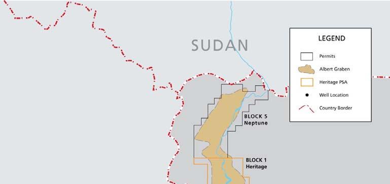
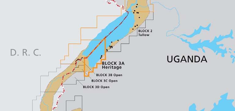
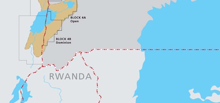
4 Figure 1 Exploration Area 3A Location Map

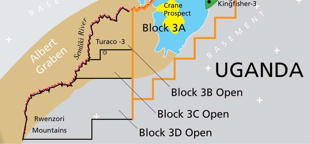
5 Figure 2 Kingfisher Field Location Map

6 Figure 3 Kingfisher Well Locations

7 Figure 4 Geometry of Basin Margin Fault at Reservoir Depth showing Restraining Bend

8 Key To Horizons PL2 Late Pleistocene PL1 Early Pleistocene P3 Late Pliocene P2 Mid Pliocene P1 Early Pliocene Figure 5 Northwest-southeast Seismic Dip Line through Kingfisher-1

9 Figure 6 Interpreted Gas Cloud on Seismic Data
10 Figure 7 Top Early Pliocene P1 Time Structure Map over the 3D Survey Area

11 Figure 8 Kingfisher Field Generalised Stratigraphic Column

12 Figure 9 Correlation of Kingfisher Reservoir Units

13 The Kingfisher Field, Uganda Figure 10 Kingfisher-3A Core Photographs

14 Figure 11 Paleogeographic Reconstruction of Proto-Congo Drainage Pattern

15 Figure 12 Paleogeographic Reconstruction of Kingfisher DFS

16 Figure 13 Restored catchment area of Kingfisher DFS
APPENDIX C GEOLOGICAL CHANCE OF SUCCESS RYDER SCOTT COMPANY PETROLEUM CONSULTANTS
 APPENDIX C GEOLOGICAL CHANCE OF SUCCESS Page 2 The Geological Chance of Success is intended to evaluate the probability that a functioning petroleum system is in place for each prospective reservoir. The
Relinquishment Report
 Relinquishment Report Licence P1403 Block 13/22d Chevron North Sea Limited Korean National Oil Company Chevron North Sea Limited December 2009 1 SYNOPSIS... 3 2 INTRODUCTION. 3 2.1 Licence Terms.. 3 2.2
Bulletin of Earth Sciences of Thailand. Evaluation of the Petroleum Systems in the Lanta-Similan Area, Northern Pattani Basin, Gulf of Thailand
 Evaluation of the Petroleum Systems in the Lanta-Similan Area, Northern Pattani Basin, Gulf of Thailand Sirajum Munira Petroleum Geoscience Program, Department of Geology, Faculty of Science, Chulalongkorn
MUHAMMAD S TAMANNAI, DOUGLAS WINSTONE, IAN DEIGHTON & PETER CONN, TGS Nopec Geological Products and Services, London, United Kingdom
 Geological and Geophysical Evaluation of Offshore Morondava Frontier Basin based on Satellite Gravity, Well and regional 2D Seismic Data Interpretation MUHAMMAD S TAMANNAI, DOUGLAS WINSTONE, IAN DEIGHTON
POTENTIAL STRATIGRAPHIC PLAY IN THE WESTERN HA LONG BASIN FROM 3D SEISMIC INVERSION AND REGIONAL GEOLOGICAL CONTEXT
 PETROLEUM EXPLORATION & PRODUCTION POTENTIAL STRATIGRAPHIC PLAY IN THE WESTERN HA LONG BASIN FROM 3D SEISMIC INVERSION AND REGIONAL GEOLOGICAL CONTEXT Nguyen Du Hung 1, Hoang Viet Bach 1, Ngo Van Quan
REGIONAL GEOLOGY IN KHMER BASIN
 CONTENTS 1-Khmere Basin 2-Regional Geology Khmer Basin 3-Regime Tectonic 4-Seismic Database -a/ Acquisition Data -b/ Prospect Angkor -C/ Cross Section Seismic 5-Play Type -a/ Play Schematic -b/ Structure
Licence P1368: Relinquishment Report (end of 2 nd term) Hurricane Exploration PLC
 Hurricane Exploration PLC") Licence P1368: Relinquishment Report (end of 2 nd term) Hurricane Exploration PLC March 2012 1. Header Licence Number: P1368 Licence Round: 23 rd Licence Type: Frontier Block Numbers: 202/4, 202/5, 204/30,
Licence P1368: Relinquishment Report (end of 2 nd term) Hurricane Exploration PLC March 2012 1. Header Licence Number: P1368 Licence Round: 23 rd Licence Type: Frontier Block Numbers: 202/4, 202/5, 204/30,
RELINQUISHMENT REPORT FOR LICENCE P.1663, BLOCK 29/4b and 29/5e
 RELINQUISHMENT REPORT FOR LICENCE P.1663, BLOCK 29/4b and 29/5e Licence: P.1663 Blocks: 29/4b & 29/5e 25th Round Traditional Licence Operator: Ithaca Energy UK(Ltd) 100% Work Programme Summary The agreed
Relinquishment Report for Licence P.1265, Block 12/28
 Relinquishment Report for Licence P.1265, Block 12/28 1. Licence Information Licence Number: P.1265 Licence Round: 23 rd Round Awarded 22 December 2005 Licence Type: Traditional Block Number(s): 12/28
Relinquishment Report. for. Licence P1605, Block 220/27
 Relinquishment Report for Licence P1605, Block 220/27 November 2013 Licence P.1605 Relinquishment Report August 2012 1 of 11 CONTENT 1 Introduction 2 - Exploration Summary 2.1 Exploration Activity 2.2
RELINQUISHMENT REPORT. License P1546 Block April 2009
 RELINQUISHMENT REPORT License P1546 Block 110-01 14 April 2009 Sherritt International Oil and Gas Limited 2000, 425-1 st street S.W., Calgary, Alberta Canada T2P 3L8 Telephone (403) 260-2900 Fax (403)
Depositional History and Petroleum Potential of Ombilin Basin, West Sumatra - Indonesia, Based on Surface Geological Data*
 Depositional History and Petroleum Potential of Ombilin Basin, West Sumatra - Indonesia, Based on Surface Geological Data* Yahdi Zaim 1, Litto Habrianta 2, Chalid I. Abdullah 1, Aswan 1, Yan Rizal 1, Nurcahyo
RELINQUISHMENT REPORT. UK Traditional Licence P Blocks 12/16b & 12/17b. First Oil Expro Limited (Operator, 46.67%)
") RELINQUISHMENT REPORT UK Traditional Licence P.1887 Blocks 12/16b & 12/17b First Oil Expro Limited (Operator, 46.67%) Nautical Petroleum Limited (26.67%) North Sea Energy (UK NO2) Limited (26.67%) February
RELINQUISHMENT REPORT UK Traditional Licence P.1887 Blocks 12/16b & 12/17b First Oil Expro Limited (Operator, 46.67%) Nautical Petroleum Limited (26.67%) North Sea Energy (UK NO2) Limited (26.67%) February
Vail et al., 1977b. AAPG 1977 reprinted with permission of the AAPG whose permission is required for further use.
 Well 5 Well 4 Well 3 Well 2 Well 1 Vail et al., 1977b AAPG 1977 reprinted with permission of the AAPG whose permission is required for further use. Well 5 Well 4 Well 3 Well 2 Well 1 Vail et al., 1977b
High-resolution Sequence Stratigraphy of the Glauconitic Sandstone, Upper Mannville C Pool, Cessford Field: a Record of Evolving Accommodation
 Page No. 069-1 High-resolution Sequence Stratigraphy of the Glauconitic Sandstone, Upper Mannville C Pool, Cessford Field: a Record of Evolving Accommodation Thérèse Lynch* and John Hopkins, Department
Abstract. Introduction. Regional Setting. GCSSEPM to be published December 2003
 Shelf Margin Deltas and Associated Deepwater Deposits: Implications on Reservoir Distribution and Hydrocarbon Entrapment, Block VI-1, Ulleung Basin, East Sea, South Korea Sneider, John S. Sneider Exploration,
ANGOLA OFFSHORE LICENSING 2007 BLOCK 46
 AGOLA OFFHOR LICIG 2007 BLOCK 46 DATA BA AVAILABILITY Figure 1 shows the seismic data available on Block 46. Fig. 1 Commercial 2D surveys: esterngeco: 794 km. GX Technology: 116 km. Commercial 3D surveys:
Controls on clastic systems in the Angoche basin, Mozambique: tectonics, contourites and petroleum systems
 P2-2-13 Controls on clastic systems in the Angoche basin, Mozambique: tectonics, contourites and petroleum systems Eva Hollebeek, Olivia Osicki, Duplo Kornpihl Schlumberger, London, UK Introduction Offshore
Bulletin of Earth Sciences of Thailand
 Quantitative Seismic Geomorphology of Early Miocene to Pleistocene Fluvial System of Northern Songkhla Basin, Gulf of Thailand Oanh Thi Tran Petroleum Geoscience Program, Department of Geology, Faculty
=%REPORT RECONNAISSANCE OF CHISHOLM LAKE PROSPECT. October 25, 1977
 =%REPORT ON FIELD RECONNAISSANCE OF CHISHOLM LAKE PROSPECT October 25, 1977 Bruce D. Vincent Imperial Oil Limited, Minerals - Coal, CALGARY, ALBERTA CHISHOLM LAKE PROSPECT Introduction The Chisholm Lake
28 th ROUND OF UK OFFSHORE LICENSING
 28 th ROUND OF UK OFFSHORE LICENSING RELINQUISHMENT REPORT LICENSE P2266 Block 47/6 Swift Exploration Ltd Stelinmatvic Industries Ltd April 2017 1 Location Licence P2266 Block 47/6 in the UK Southern Gas
NORTHEAST RAMADAN BLOCK
 LOCATION : The block lies in the eastern side of the central part of the Gulf of Suez basin north and south of BP Ramadan, SB and Morgan fields. 2D &3D SEISMIC COVERAGE AREA : 219 km 2 WELLS : 5 Wells
Petroleum geology framework, West Coast offshore region
 Petroleum geology framework, West Coast offshore region James W. Haggart* Geological Survey of Canada, Vancouver, BC jhaggart@nrcan.gc.ca James R. Dietrich Geological Survey of Canada, Calgary, AB and
1 Licence Number and Block Details
 Licence Number and Block Details 1 Licence Number and Block Details Table 1.1: Licence details. Licence Number: P1343 Licence Round: 23rd Round Licence Type: Traditional Block(s): 43/30b, 48/05a & 49/01b
Lower Skinner Valley Fill Sandstones: Attractive Exploration Targets on the Northeast Oklahoma Platform*
 Lower Skinner Valley Fill Sandstones: Attractive Exploration Targets on the Northeast Oklahoma Platform* By Jim Puckette 1 Search and Discovery Article #10050 (2003) *Adapted from presentation to Tulsa
Hydrocarbon Potential of the Marginal Fields in Niger Delta Oza Field, a case study*
 Hydrocarbon Potential of the Marginal Fields in Niger Delta Oza Field, a case study* J.N. Sahu 1, C.H.V. Satya Sai 1, V. Chintamani 1 and C. Vishnu Vardhan 1 Search and Discovery Article #20182 (2012)*
Seismic Stratigraphy of the Fang Basin, Chiang Mai, Thailand Rungsun Nuntajun
 Chiang Mai J. Sci. 2009; 36(1) 77 Chiang Mai J. Sci. 2009; 36(1) : 77-82 www.science.cmu.ac.th/journal-science/josci.html Contributed Paper Seismic Stratigraphy of the Fang Basin, Chiang Mai, Thailand
BALOCHISTAN FOLDBELT BASIN
 INTRODUCTION BALOCHISTAN FOLDBELT BASIN The Kharan-3 block is located in the Kharan Trough of Balochistan Basin. GEOLOGICAL SETTING The Balochistan Province is an Upper Cretaceous to Recent structurally
Relinquishment report P.1190 & P Blocks: 204/13, 204/14b
 Relinquishment report P.1190 & P.1262 Blocks: 204/13, 204/14b CONTENTS 1: LICENCE DETAILS... 2 2: LICENCE SYNOPSIS... 2 3: WORK PROGRAMME SUMMARY... 3 4. DATABASE... 5 5: PROSPECTIVITY UPDATE... 6 6. RESERVE
Bulletin of Earth Sciences of Thailand. Controls on Reservoir Geometry and Distribution, Tantawan Field, Gulf of Thailand.
 Controls on Reservoir Geometry and Distribution, Tantawan Field, Gulf of Thailand Atchara Praidee Petroleum Geoscience Program, Department of Geology, Faculty of Science, Chulalongkorn University, Bangkok
Airborne gravity gradiometer surveying of petroleum systems under Lake Tanganyika, Tanzania
 Airborne gravity gradiometer surveying of petroleum systems under Lake Tanganyika, Tanzania D. Roberts Beach Energy P. Roy Chowdhury CGG S. J. Lowe CGG A. N. Christensen CGG Outline Introduction Geology
NORTHEAST EL HAMD BLOCK
 NORTHEAST EL HAMD BLOCK NORTHEAST EL HAMD BLOCK LOCATION : The block is locating in the eastern side of the central part of the Gulf of Suez basin west and south of Belayim fields. NORTHEAST EL HAMD BLOCK
Ministry of Oil and Minerals Petroleum Exploration & Production Authority BLOCK 85 (Al Uqlah North)
") Ministry of Oil and Minerals Petroleum Exploration & Production Authority BLOCK 85 (Al Uqlah North) The Al Uqlah North Block (85) occupies an area of 597 km 2 in the Sabatayn Basin in the province of Shabwah
Ministry of Oil and Minerals Petroleum Exploration & Production Authority BLOCK 85 (Al Uqlah North) The Al Uqlah North Block (85) occupies an area of 597 km 2 in the Sabatayn Basin in the province of Shabwah
GeoCanada 2010 Working with the Earth
 Lithofacies Identification and the Implications for SAGD Well Planning in the McMurray Formation, Christina Lake Area, Alberta Travis Shackleton*, Robert Gardner, Sung Youn, Grace Eng and Lori Barth Cenovus
P.1619 License Relinquishment Report
 P.1619 License Relinquishment Report Effective Date: 14 th October 2015 1. Licence Information License Number: P.1619 License Round: 25 th License Type: Traditional Block Number(s): 21/27b Operator: MOL
Relinquishment Report Licence P1834
 Valiant Causeway Limited, March 2013 1. Header Licence Number: P1834 Licence Round: 26th Round Licence Type: Traditional Block Number: 204/21, 22b, 23b & 26a Partners: Valiant 100% (Operator) 2. Synopsis
EGAS. Ministry of Petroleum
 EGAS Ministry of Petroleum EGAS Ministry of Petroleum About The Block Location: N. El Arish offshore block is located in the extreme eastern part of the Egypt s economic water border and bounded from the
EGAS. Ministry of Petroleum
 EGAS Ministry of Petroleum EGAS Ministry of Petroleum About The Block Location: N. Thekah offshore block is located at about 56 km to the north of the Mediterranean shore line, 85 km to the north west
A comparison of structural styles and prospectivity along the Atlantic margin from Senegal to Benin. Peter Conn*, Ian Deighton* & Dario Chisari*
 A comparison of structural styles and prospectivity along the Atlantic margin from Senegal to Benin Overview Peter Conn*, Ian Deighton* & Dario Chisari* * TGS, Millbank House, Surbiton, UK, KT6 6AP The
Trapping Mechanisms along North Similan and Lanta Trends, Pattani Basin, Gulf of Thailand
 Trapping Mechanisms along North Similan and Lanta Trends, Pattani Basin, Gulf of Thailand Piyaporn Aukkanit Petroleum Geoscience Program, Department of Geology, Faculty of Science, Chulalongkorn University,
Plumbing the Depths of the Pelican Field
 Plumbing the Depths of the Pelican Field Thurza Frenz Pelican Talk Objectives To discuss the development of the northern area of the Pelican Field, in particular: The relationship between reservoir quality,
Appraising a late-middle-aged Brent Group field
 Appraising a late-middle-aged Brent Group field Reservoir learnings after nearly 20 years of Pelican field production Jill Marriott The Pelican Field The Pelican oil field is nearly 20 years old It is
Blocks 31, 32, 33, 34, 35 & 36/03 Southeast Offshore Vietnam
 Blocks 31, 32, 33, 34, 35 & 36/03 Southeast Offshore Vietnam Block 31 32 33 34 35 36/03 Area (km 2) 5,036 4,440 4,630 4,700 4,630 2,950 Sea level (m) 20 20-30 30-40 50 50 50 Seismic 2D (km) 1,294 685 431
Continuity and Compartmentalization of Viking Formation gas production from the Ricinus / Bearberry area of the Rocky Mountain Triangle Zone
 Page No. 001-1 Continuity and Compartmentalization of Formation gas production from the Ricinus / Bearberry area of the Rocky Mountain Triangle Zone David Halwas* (Senior Staff Geologist), Darryl Parry
SAND DISTRIBUTION AND RESERVOIR CHARACTERISTICS NORTH JAMJUREE FIELD, PATTANI BASIN, GULF OF THAILAND
 SAND DISTRIBUTION AND RESERVOIR CHARACTERISTICS NORTH JAMJUREE FIELD, PATTANI BASIN, GULF OF THAILAND Benjawan KIinkaew Petroleum Geoscience Program, Department of Geology, Faculty of Science, Chulalongkorn
EAS 233 Geologic Structures and Maps Winter Miscellaneous practice map exercises. 1. Fault and separation:
 Miscellaneous practice map exercises 1. Fault and separation: With respect to Map 1, what are (a) the orientation of the fault, and (b) the orientation of bedding in the units cut by the fault. (c) Mark
LICENCE RELINQUISHMENT REPORT UKCS LICENCE P.1084 SUB-BLOCK 13/27a DEE DANA PETROLEUM (E&P) LIMITED UK EXPLORATION
 LIMITED UK EXPLORATION") LICENCE RELINQUISHMENT REPORT UKCS LICENCE P.1084 SUB-BLOCK 13/27a DEE DANA PETROLEUM (E&P) LIMITED UK EXPLORATION December 2011 TABLE OF CONTENTS LIST OF TABLES & FIGURES... 3 LICENCE INFORMATION... 4
LICENCE RELINQUISHMENT REPORT UKCS LICENCE P.1084 SUB-BLOCK 13/27a DEE DANA PETROLEUM (E&P) LIMITED UK EXPLORATION December 2011 TABLE OF CONTENTS LIST OF TABLES & FIGURES... 3 LICENCE INFORMATION... 4
Petroleum Potential of the Application Area L12-4
 Petroleum Potential of the Application Area L12-4 The Application Area (L12-4) is underlain by the western Officer Basin, beneath the Gunbarrel Basin. The general basin architecture is outlined in Figure
Distribution of Overpressure and its Prediction in Saurashtra Dahanu Block, Western Offshore Basin, India*
 Distribution of Overpressure and its Prediction in Saurashtra Dahanu Block, Western Offshore Basin, India* Kanak R. Nambiar 1, B.K. Singh 2, R.N. Goswami 2, and K.R.K. Singh 2 Search and Discovery Article
Bulletin of Earth Sciences of Thailand. A study of Reservoir Connectivity in the Platong Field, Pattani Basin, Gulf of Thailand. Hathairat Roenthon
 A study of Reservoir Connectivity in the Platong Field, Pattani Basin, Gulf of Thailand Hathairat Roenthon Petroleum Geoscience Program, Department of Geology, Faculty of Science, Chulalongkorn University,
Evolution of the Geological Model, Lobster Field (Ewing Bank 873)
") Evolution of the Geological Model, Lobster Field (Ewing Bank 873) M.K. Burk, Marathon Oil Company G.L. Brown, Marathon Oil Company D.R. Petro, Marathon Oil Company Throughout the life of a field an accurate
Evolution of the Geological Model, Lobster Field (Ewing Bank 873) M.K. Burk, Marathon Oil Company G.L. Brown, Marathon Oil Company D.R. Petro, Marathon Oil Company Throughout the life of a field an accurate
eni s.p.a. upstream & technical services
 eni s.p.a. upstream & technical services 2013-2014 Master in Petroleum Engineering and Operations Congo & Angola Offshore-Congo River Basin Characteristics, exploitation approach and fields analogues Author:
The Stratigraphic Trap in the Benchamas Field Pattani Basin, Gulf of Thailand
 The Stratigraphic Trap in the Benchamas Field Pattani Basin, Gulf of Thailand Jurairat Buangam Petroleum Geoscience Program, Department of Geology, Faculty of Science, Chulalongkorn University, Bangkok
BARRYROE OIL IN PLACE RESOURCE UPDATE
 July 25 th 2012 Embargo 7am BARRYROE OIL IN PLACE RESOURCE UPDATE UPDATED OIL IN PLACE ESTIMATES RESERVOIR INTERVAL P50 (MMBO) P10 (MMBO) MIDDLE WEALDEN 287 706 BASAL WEALDEN 756 906 TOTAL 1,043 1,612
Geology Stratigraphic Correlations (Lab #4, Winter 2010)
") Name: Answers Reg. lab day: Tu W Th Geology 1023 Stratigraphic Correlations (Lab #4, Winter 2010) Introduction Stratigraphic correlation is the process of comparing rocks at one locality with related rocks
Name: Answers Reg. lab day: Tu W Th Geology 1023 Stratigraphic Correlations (Lab #4, Winter 2010) Introduction Stratigraphic correlation is the process of comparing rocks at one locality with related rocks
Revised reservoir model for the Paleocene mounds of the Utsira High, North Sea, Norway John Wild (1) & Nowell Briedis (2)
 & Nowell Briedis (2)") Revised reservoir model for the Paleocene mounds of the Utsira High, North Sea, Norway John Wild (1) & Nowell Briedis (2) (1) Mobil North Sea LLC (2) Esso Exploration & Production Norway A/S (ExxonMobil
Revised reservoir model for the Paleocene mounds of the Utsira High, North Sea, Norway John Wild (1) & Nowell Briedis (2) (1) Mobil North Sea LLC (2) Esso Exploration & Production Norway A/S (ExxonMobil
Relinquishment Report
 Relinquishment Report Licence P.089 Block 22/15a 2 nd Round Traditional Licence Award (Operator): 100.0% Disclaimer No representation or warranty, express or implied, is or will be made in relation to
Sediment and sedimentary rocks Sediment
 Sediment and sedimentary rocks Sediment From sediments to sedimentary rocks (transportation, deposition, preservation and lithification) Types of sedimentary rocks (clastic, chemical and organic) Sedimentary
Licence Relinquishment Report. P.1400 Block 12/30. First Oil Expro Ltd
 Licence Relinquishment Report P.1400 Block 12/30 First Oil Expro Ltd December 2007 Seaward Production Licence P.1400, Block 12/30 Block 12/30 was awarded 100% to Reach Exploration North Sea Ltd as a promote
RWE Dea UK SNS Limited (50%, operator) Dana Petroleum (E&P) Limited (50%)
 Dana Petroleum (E&P) Limited (50%)") 1. Licence Information Licence Number P1726 Licence Round 25 th (2008) Licence Type Traditional Blocks 43/17a & 43/18a Licensees Work Programme RWE Dea UK SNS Limited (50%, operator) Dana Petroleum (E&P)
1. Licence Information Licence Number P1726 Licence Round 25 th (2008) Licence Type Traditional Blocks 43/17a & 43/18a Licensees Work Programme RWE Dea UK SNS Limited (50%, operator) Dana Petroleum (E&P)
Meandering Miocene Deep Sea Channel Systems Offshore Congo, West Africa
 Meandering Miocene Deep Sea Channel Systems Offshore Congo, West Africa S. Baer* (PGS), J. E. Comstock (PGS), K. Vrålstad (PGS), R. Borsato (PGS), M. Martin (PGS), J.P. Saba (SNPC), B. Débi-Obambé (SNPC)
5 ORIGINAL HYDROCARBONS IN PLACE
 5 ORIGINAL HYDROCARBONS IN PLACE The deterministic estimation of oil in place for the White Rose Field was completed using 3-D geological modelling in the RMS software package. This procedure involves
RWE Dea UK SNS Limited (50%), Faroe Petroleum (UK) Limited
, Faroe Petroleum (UK) Limited") 1. Licence information Licence Number P1975 Licence Round 27 th (2012) Licence Type Traditional Blocks 3/28c & 9/3e Licensees Work Programme 2. Synopsis RWE Dea UK SNS Limited (50%), Faroe Petroleum (UK)
1. Licence information Licence Number P1975 Licence Round 27 th (2012) Licence Type Traditional Blocks 3/28c & 9/3e Licensees Work Programme 2. Synopsis RWE Dea UK SNS Limited (50%), Faroe Petroleum (UK)
Perspectives from Offshore Argentina & Uruguay
 Perspectives from Offshore Argentina & Uruguay A Prospectivity Overview Hannah Kearns October 2018 Introduction Argentina Offshore License Round 1 14 blocks Argentina North, 24 Austral-Malvinas Offshore
Licence P.185, Blocks 30/11b and 30/12b Relinquishment Report February 2015
 1. General Licence: P.185 Round: 4 th (1972) Licence Type: Traditional Blocks: 30/11b (part) and 30/12b (part) Equity: Talisman Sinopec Energy UK Limited 60%, Centrica North Sea Oil Limited 40% Work Programme:
UK P2060, Block 29/06b Licence Relinquishment
 ENDEAVOUR ENERGY UK LIMITED UK P2060, Block 29/06b Licence Relinquishment ISSUE RECORD SUMMARY Dec 2015 Final Graham Tegerdine Rev Date Description Document Owner Review Required By Table of Contents 1
Ministry of Oil and Minerals Petroleum Exploration & Production Authority BLOCK 6 (Iryam)
") Ministry of Oil and Minerals Petroleum Exploration & Production Authority BLOCK 6 (Iryam) The Iryam Block (6) occupies an area of 3,911 km 2 in the Sabatayn Basin in the province of Shabwah in central
Ministry of Oil and Minerals Petroleum Exploration & Production Authority BLOCK 6 (Iryam) The Iryam Block (6) occupies an area of 3,911 km 2 in the Sabatayn Basin in the province of Shabwah in central
Serica Energy (UK) Limited. P.1840 Relinquishment Report. Blocks 210/19a & 210/20a. UK Northern North Sea
 Limited. P.1840 Relinquishment Report. Blocks 210/19a & 210/20a. UK Northern North Sea") Serica Energy (UK) Limited P.1840 Relinquishment Report Blocks 210/19a & 210/20a UK Northern North Sea January 2013 1 Header Licence: P.1840 Round: Licence Type: 26th Round Traditional "Drill-or-Drop"
Serica Energy (UK) Limited P.1840 Relinquishment Report Blocks 210/19a & 210/20a UK Northern North Sea January 2013 1 Header Licence: P.1840 Round: Licence Type: 26th Round Traditional "Drill-or-Drop"
KENYA ONSHORE, LAMU BASIN Block L14 FARM- IN OPPORTUNITY
 KENYA ONSHORE, LAMU BASIN Block L14 FARM- IN OPPORTUNITY Lamu Oil and Gas, a joint venture between QFB and Edgo Energy, is seeking one or more partners, to continue exploration of their highly attractive
OIL INDIA LIMITED, GEOPHYSICS DEPARTMENT, DULIAJAN, ASSAM.
 J. P. Singh, M. K. Gupta & Akshaya Kumar, Oil India Limited, Duliajan. jpsingh@oilindia.in Summary Oil exploration in Upper Assam commenced with the discovery of the Digboi oilfield more than 100 years
New Portfolio Asset - Namibia
 Market Announcements Platform ASX Limited Exchange Centre 20 Bridge Street Sydney NSW 2000 ASX Code: CE1 10/05/2018 New Portfolio Asset - Namibia Highlights: Calima has been awarded a 56% interest and
Devonian Petroleum Systems and Exploration Potential, Southern Alberta, Part 3 Core Conference
 Devonian Petroleum Systems and Exploration Potential, Southern Alberta, Part 3 Core Conference Andy Mort (1), Leonard Stevens (2), Richard Wierzbicki (2) Abstract Part 1: Devonian Petroleum Systems Dr.
Figure 1 Extensional and Transform Fault Interaction, Influence on the Upper Cretaceous Hydrocarbon System, Equatorial Margin, West Africa.
 Figure 1 Extensional and Transform Fault Interaction, Influence on the Upper Cretaceous Hydrocarbon System, Equatorial Margin, West Africa. Presented to the 10th PESGB/HGS Conference on Africa E + P September
Evaluation of Neocomian Shale source rock In Komombo Basin, Upper Egypt
 Evaluation of Neocomian Shale source rock In Komombo Basin, Upper Egypt Abdelhady, A. 1, Darwish, M. 2, El Araby, A. 3 and Hassouba, A. 4 1 DEA Egypt, Cairo, Egypt 2 Geology Department, Faculty of Science,
For personal use only
 ASX ANNOUNCEMENT 11 September 2018 Billion Barrel Oil Potential Assessed in Pancontinental s PEL 87 Offshore Namibia Giant* scale oil potential in multiple Large Leads in PEL 87 Vast Cretaceous Superfan
The Waitsia Field. Onshore North Perth Basin, Western Australia. APPEA Conference, Brisbane 6 June 2016
 Photograph by Roger Xiang The Waitsia Field Onshore North Perth Basin, Western Australia N. Tupper, E. Matthews, G. Cooper, A. Furniss, T. Hicks and S. Hunt APPEA Conference, Brisbane 6 June 2016 1 Disclaimer
Relinquishment Report. for. Licence P.272 Block 20/7a
 Relinquishment Report for Licence P.272 Block 20/7a February 2007 1 of 16 CONTENT 1 - Introduction 2 - Exploration Activities 2.1 - Purchase 130km2 of Aker 1999 survey 2.2 Reprocessing of 3D Aker data
Dakota Sandstone. of the Moxa Arch and Surrounding Green River Basin
 Dakota Sandstone of the Moxa Arch and Surrounding Green River Basin Dakota Sandstones of the Green River Basin Overview The Dakota sandstones of the Moxa Arch and surrounding Green River Basin remain attractive
P1488 DECC Relinquishment Report OMV (U.K.) Ltd.
 Ltd.") 1. Synopsis: P1488 DECC Relinquishment Report OMV (U.K.) Ltd. UK offshore Licence P1488 was awarded to OMV, Dana Petroleum and Rocksource in the 24 th Licence Round on the 24 th of January 2007 as a frontier
1. Synopsis: P1488 DECC Relinquishment Report OMV (U.K.) Ltd. UK offshore Licence P1488 was awarded to OMV, Dana Petroleum and Rocksource in the 24 th Licence Round on the 24 th of January 2007 as a frontier
Relinquishment Report for Licence Number P1471 Block 16/8f March 2009
 Relinquishment Report for Licence Number P1471 Block 16/8f March 2009 Endeavour Energy UK Ltd Relinquishment Report for Licence Number P1471 Block 16/8f 1 Table of Contents 1.0 Header...3 2.0 Synopsis...3
Search and Discovery Article #40507 (2010) Posted February 12, Abstract
 Posted February 12, Abstract") Click to view slides prepared for presentation. Application of From Seismic Interpretation to Tectonic Reconstruction Methodology to Study Pre-Tertiary Fractured Granite Basement Reservoir in Cuu Long
Click to view slides prepared for presentation. Application of From Seismic Interpretation to Tectonic Reconstruction Methodology to Study Pre-Tertiary Fractured Granite Basement Reservoir in Cuu Long
Structural Geology of the Mountains
 Structural Geology of the Mountains Clinton R. Tippett Shell Canada Limited, Calgary, Alberta clinton.tippett@shell.ca INTRODUCTION The Southern Rocky Mountains of Canada (Figure 1) are made up of several
Seismic Attributes and Their Applications in Seismic Geomorphology
 Academic article Seismic Attributes and Their Applications in Seismic Geomorphology Sanhasuk Koson, Piyaphong Chenrai* and Montri Choowong Department of Geology, Faculty of Science, Chulalongkorn University,
Sedimentary Cycle Best Practice: Potential Eo-Oligocene Sediments in Western Indonesia*
 Sedimentary Cycle Best Practice: Potential Eo-Oligocene Sediments in Western Indonesia* Mellinda Arisandy 1 and I Wayan Darma 1 Search and Discovery Article #11008 (2017)** Posted November 6, 2017 *Adapted
HYDROCARBON EXPLORATION IN THE ALBERTINE GRABEN OF THE EAST AFRICAN RIFT SYSTEM
 IN THE ALBERTINE GRABEN OF THE EAST AFRICAN RIFT SYSTEM GEOPRISM; EAST AFRICAN RIFT SYSTEM PLANNING WORKSHOP By: Dozith Abeinomugisha Ministry of Energy and Mineral Development, Entebbe, Uganda 1 BACKGROUND
Ground-Water Exploration in the Worthington Area of Nobles County: Summary of Seismic Data and Recent Test Drilling Results
 Ground-Water Exploration in the Worthington Area of Nobles County: Summary of Seismic Data and Recent Test Drilling Results Jim Berg and Todd Petersen Geophysicists, DNR Waters January 2000 Table of Contents
Evan K. Franseen, Dustin Stolz, Robert H. Goldstein, KICC, Department of Geology, University of Kansas
 Reservoir Character of the Avalon Shale (Bone Spring Formation) of the Delaware Basin, West Texas and Southeast New Mexico: Effect of Carbonate-rich Sediment Gravity Flows Evan K. Franseen, Dustin Stolz,
Soils, Hydrogeology, and Aquifer Properties. Philip B. Bedient 2006 Rice University
 Soils, Hydrogeology, and Aquifer Properties Philip B. Bedient 2006 Rice University Charbeneau, 2000. Basin Hydrologic Cycle Global Water Supply Distribution 3% of earth s water is fresh - 97% oceans 1%
Swala Energy Limited
 Swala Energy Limited (ASX: SWE) Unlocking Frontier Basins in the East African Rift Alicia Strother, Geoscientist 9 th September 2014 Good Oil Conference Presentation www.swala-energy.com 1 Disclaimer Certain
The McCully gas field in southern New Brunswick was discovered in the year 2000 on a joint drilling exploration venture by Corridor Resources Inc.
 1 The McCully gas field in southern New Brunswick was discovered in the year 2000 on a joint drilling exploration venture by Corridor Resources Inc. and Potash Corporation of Saskatchewan. Located about
We P2 04 Rock Property Volume Estimation Using the Multiattribute Rotation Scheme (MARS) - Case Study in the South Falkland Basin
 - Case Study in the South Falkland Basin") We P2 04 Rock Property Volume Estimation Using the Multiattribute Rotation Scheme (MARS) - Case Study in the South Falkland Basin P.K. Alvarez* (Rock Solid Images), B. Farrer (Borders & Southern Petroleum),
We P2 04 Rock Property Volume Estimation Using the Multiattribute Rotation Scheme (MARS) - Case Study in the South Falkland Basin P.K. Alvarez* (Rock Solid Images), B. Farrer (Borders & Southern Petroleum),
LOCATION : The two blocks are locating in the western side of the central part
 1&2 NORTHEAST OCTOBER & NORTH ISSRAN BLOCKS N. ISSRAN BLOCK NE OCTOBER LOCATION : The two blocks are locating in the western side of the central part of the Gulf of Suez basin west of October fields. 1
Unlocking and Developing the Potential of Exciting Core Plays. Manu Wope South and East Africa Capital Markets Day 1
 Unlocking and Developing the Potential of Exciting Core Plays Manu Wope South and East Africa 1 Tullow s Footprint in South and East Africa Overview Largest exposure to fledging East African Rift exploration
High Resolution Field-based Studies of Hydrodynamics Examples from the North Sea
 High Resolution Field-based Studies of Hydrodynamics Examples from the North Sea Stephen O Connor 1, Richard Swarbrick 2 and Sam Green 1 1 Ikon GeoPressure, Durham, UK 2 Swarbrick Geopressure Consultancy,
Figure 1: Location and bathymetry of the study area. Gulf of Guinea. Cameroon. Congo. Gabon. PGS/DGH Gabon MegaSurvey Coverage (35000Km 2 ) Eq.
 Eq.") Deepwater hydrocarbon prospectivity analysis of offshore North and South Gabon Muhammad S Tamannai (*), Thomas Hansen (1), Ron Borsato (1), Jennifer Greenhalgh (1) Martial-Rufin Moussavou (2) & Landry
Deepwater hydrocarbon prospectivity analysis of offshore North and South Gabon Muhammad S Tamannai (*), Thomas Hansen (1), Ron Borsato (1), Jennifer Greenhalgh (1) Martial-Rufin Moussavou (2) & Landry
1. LICENCE INFORMATION. P209 Block 9/29a ALL. U.K. Block 9/29a (Part Block) Operator/Partners TAQA Bratani Ltd 81%, RWE DEA UK 19%
 Operator/Partners TAQA Bratani Ltd 81%, RWE DEA UK 19%") 1. LICENCE INFORMATION Licence P209 Block 9/29a ALL Licence Round 4th round Blocks U.K. Block 9/29a (Part Block) Licence Type Traditional (Production) Well Operator TAQA Bratani Ltd Operator/Partners TAQA
1. LICENCE INFORMATION Licence P209 Block 9/29a ALL Licence Round 4th round Blocks U.K. Block 9/29a (Part Block) Licence Type Traditional (Production) Well Operator TAQA Bratani Ltd Operator/Partners TAQA
THE NORTH SUMATERA BASIN : GEOLOGICAL FRAMEWORK & PETROLEUM SYSTEM REVIEW
 THE NORTH SUMATERA BASIN : GEOLOGICAL FRAMEWORK & PETROLEUM SYSTEM REVIEW By the Delegation of Indonesia : Bambang Wicaksono TM* Jonathan Setyoko H* Hermes Panggabean** * Lemigas ** PSG Krabi, 12-15 May
Connecticut's Aquifers
 Page 1 of 5 DEP Search: Connecticut's Aquifers The technical definition of the word "aquifer" is: any geologic formation capable of yielding significant quantities of water to wells. By that definition,
Geology & Geophysics Applied in Industry. EXERCISE 2: A Quick-Look Evaluation
 EXERCISE 2: A Quick-Look Evaluation You have been asked to perform a quick back-of-the-envelope evaluation of the blocks being offered off of Somewhereia. Is there enough potential that our company should
PROCEEDINGS, INDONESIAN PETROLEUM ASSOCIATION Forty-First Annual Convention & Exhibition, May 2017
 IPA17-369-SG PROCEEDINGS, INDONESIAN PETROLEUM ASSOCIATION Forty-First Annual Convention & Exhibition, May 2017 FACIES ANALYSIS OF LATE NEOGENE DEPOSIT: MARINE TO CONTINENTAL ENVIRONMENT OF THE MERAPI