Alex Haluszka Gordon MacMillan Matrix Solutions Inc. Simon Maev Laurus Energy Canada Inc.
|
|
|
- Cody Webb
- 6 years ago
- Views:
Transcription


1 Alex Haluszka Gordon MacMillan Matrix Solutions Inc. Simon Maev Laurus Energy Canada Inc.
2 Objectives Underground Coal Gasification has potential in Alberta UCG background UCG and groundwater Laurus Energy Demonstration Project Multi disciplined approach to project assessment Geologic and hydrogeologic setting Geologic mapping Hydrogeologic numerical model
3 What is UCG? coal gasification converts coal into synthesis gas (syngas) can be applied to mined coal at the surface (Genesee) UCG applied to non mined coal seams using injection and production wells oxidant injected, coal is ignited and burns (up to 1250 o C), series of chemical reactions = syngas syngas uses: chemical feedstock or fuel for electrical power generation (e.g. IGCC) UCG produces a relatively pure stream of H 2 (upgrading) CO 2 byproduct is easily stripped from syngas (CCS, EOR)
4 UCG Timeline Late 1800 s Theory Development 1930 s to 1960 s More than 12 commercial plants in USSR 1960 s to 2000 Pilot projects in North America and Europe 21 st Century Commercial development in North America, Australia and Africa
5 How can UCG effect groundwater? water is needed as a reactant the rate of water influx into the coal seams influences the quality and composition of the syngas. Basic Equation: Coal + O 2 + H 2 O H 2 + CO Water gas shift: H 2 O + CO CO 2 + H 2 byproducts created include heat, water with dissolved concentrations of ammonia, phenols, salts, polyaromatic hydrocarbons, and liquid organic products from the pyrolysis of coal.


6 εucg Process Overview Laurus has licensed εucg from Ergo Exergy Technologies Inc. Injection Well Production Well Ergo Exergy, 2010

7 εucg Process Overview εucg Process successfully applied at Chinchilla site in Australia from : no groundwater contamination no subsidence no surface contamination controlled shutdown property returned to prior use annual independent audits and full compliance with environmental regulations 9 process wells; capacity 80,000 Nm3/h (eq. 70MWe) 35,000 t of coal extracted, Over 80 million m 3 of gas, LHV=5.0 MJ/Nm 3, p = 1100 kpa, t = 300 o C Courtesy of Ergo Exergy Technologies Inc.

8 UCG in Alberta Geologic conditions: seam thickness structurally integral, continuous 1 1. Mannville coals Swan Hills Synfuels with Alberta Energy Research Institute, 2008 Hydrogeologic conditions: saturated conditions sufficient hydrostatic pressure hydraulically isolated from surrounding aquifers 2 2. Ardley coals Laurus Energy, Horseshoe Canyon coals Nordic Oil and Gas, (Alberta Department of Energy, Coal Activity Map, July 30, 2009), Information from Pana (2009)


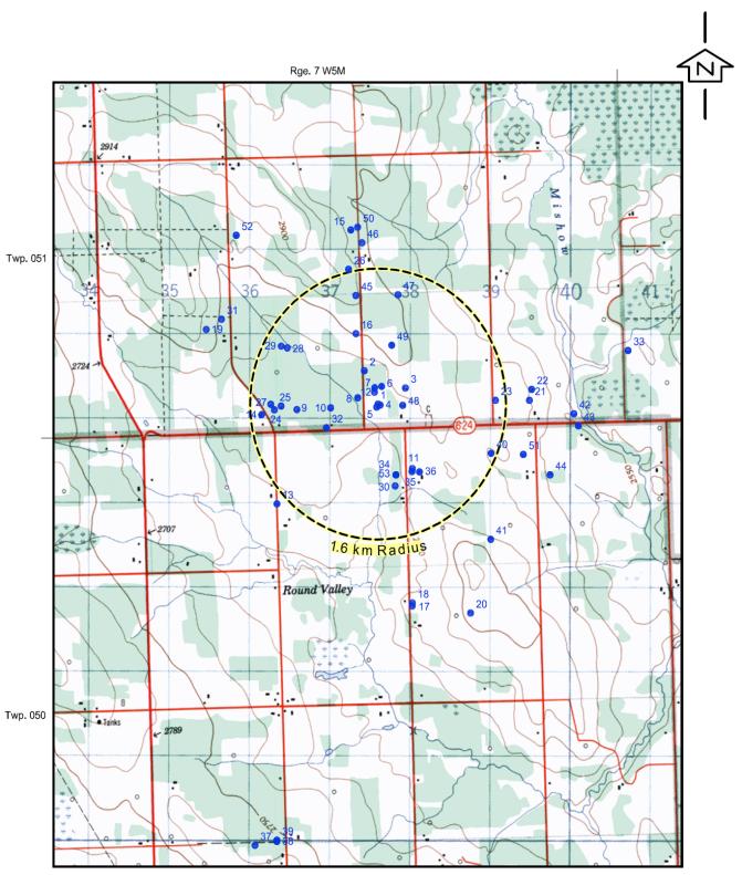
9 Laurus Energy Demonstration Project y near Drayton Valley, Alberta y Demonstration to produce 70,000 Sm3/d of syngas for one year, approx 9,865 t of coal to be extracted y groundwater monitoring before, during and after demonstration project


10 Hydrogeology Assessment study area boundaries based on surface hydrologic features where possible surface topography is rolling high in SW decreasing towards NE and Wabamun Lake Farmland with active oil and gas production, coal mining Pembina River Wabamun Lake North Saskatchewan River


11 Geological Setting target for gasification is the Ardley geologic units dip gently towards SW Ardley coal zone subcrops near Wabamun Lake Ardley at 200 m depth at project 111 wells within the RSA reviewed and 2 regional cross sections, integrated with public data (AGS, etc.)
 Laramie River, Wyoming Wikipedia,")
12 Paskapoo Formation Facies Models From Galloway and Sharp (1998) Laramie River, Wyoming Wikipedia, 2010

 sandstone exposed in outcrop due to weathering, actually >50% siltstone and shale")
13 Paskapoo Formation deposited in ancient non marine, fluvial channels and floodplains (Dawson et al., 1994) Stacked and amalgamated channels up to 50 m thick (Pana, 2007 and Grasby et al., 2008) sandstone exposed in outcrop due to weathering, actually >50% siltstone and shale in subsurface (Grasby et al., 2008) Paskapoo Formation sandstone, Calgary, Wikipedia, 2010
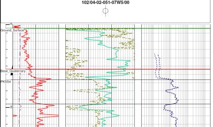
 PKSS3")
14 Paskapoo Formation NW SE PKSS4 PKSS1 PKSS2 PKSS3 sheet like, laterally extensive, amalgamated channel sandstone bodies (Pana, 2007) PKSS3 PKSS2
15 Hydrogeological Setting Domestic use Aquifer
 and incised river valleys discrete sand")
 amalgamated sand aquifers control regional GW flow and pressure")
16 Geology and Hydrogeology How does Paskapoo geology data help hydrogeological interpretation? area with undulating topography (~250 m of relief) and incised river valleys discrete sand packages on regional scale separated by low bulk hydraulic conductivities (shale and thin siltstone/sandstone) amalgamated sand aquifers control regional GW flow and pressure distribution
 data used for geology interpretation and hydrogeological numerical model enabled a detailed site specific hydrogeological")
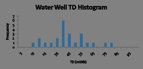
17 Laurus Energy Groundwater Monitoring Laurus completed detailed groundwater monitoring drilling program (geophysical well logs, pressure transducers, vibrating wire piezometers) data used for geology interpretation and hydrogeological numerical model enabled a detailed site specific hydrogeological assessment


18 Hydrogeologic Numerical Model Structure and isopach of geological units imported into model PKSS2 Present


19 Hydrogeologic Numerical Model Integration of geometry and hydraulic conductivity
20 Model Calibration Steady state results compared to measured hydrogeological data
21 Hydrogeologic Numerical Model Conclusions modeled geologic geometry and hydraulic conductivities result in a reasonable representation of the hydrogeological system discrete sand packages in the Paskapoo control regional groundwater flow gradients easily reproduced in numerical model with simple boundary conditions
22 Hydrogeology Assessment Conclusions Underground Coal Gasification has potential in Alberta and risks to groundwater can be minimized by a properly designed project project planning and site selection needs to involve a multi disciplined approach including detailed geologic mapping and hydrogeologic mapping in complex hydrogeological settings, good geological understanding at an appropriate scale simplifies the problem

23
24 References Dawson, F.M., Evans, C.G., Marsh, R., and Richardson, R., Uppermost Cretaceous and Tertiary Strata ; in Geological Atlas of the Western Canada Sedimentary Basin, G.D. Mossop and I. Shetsen (comp.), Canadian Society of Petroleum Geologists and Alberta Research Council, < Accessed March 30, Galloway, W. E., and Sharp, J. M., Jr., 1998, Characterizing aquifer heterogeneity within terrigenous clastic depositional systems, in Concepts in hydrogeology and environmental geology, I: SEPM (Society for Sedimentary Geology), p Grasby, S.E., Chen, Z., Hamblin, A.P., Wozniak, P.R.J., and Sweet, A.R., Regional characterization of the Paskapoo bedrock aquifer system, southern Alberta. Canadian Journal of Earth Sciences, 45, Pana, C., Ardley Coal Zone Characterization and Coal Sandstone Channels Architecture, Pembina CBM Exploration Block, Alberta. EUB/AGS Earth Sciences Report , 152 pp. Pana, C., and Richardson, R., Underground Coal Gasification Process A Potential Source of Energy in Alberta. Presentation at Canadian Society of Unconventional Gas annual convention, 2009.
Glauconitic Oil Reservoirs in Southern Alberta Creating the Correct Geological Model to Guide Development Drilling
 Glauconitic Oil Reservoirs in Southern Alberta Creating the Correct Geological Model to Guide Development Drilling Brad Hayes* Petrel Robertson Consulting Ltd, Calgary, AB bhayes@petrelrob.com Lisa Griffith
Buried Bedrock Channels in the Athabasca Oil Sands Region Conceptual Understanding and Implications to Water Supply
 Buried Bedrock Channels in the Athabasca Oil Sands Region Conceptual Understanding and Implications to Water Supply Scott Rayner Matrix Solutions Inc. Sandra Rosenthal Devon Canada Corporation Presentation
Origin and Evolution of Formation Waters in the West-Central Part of the Alberta Basin
 Page No. 004-1 Origin and Evolution of Formation Waters in the West-Central Part of the Alberta Basin Karsten Michael* University of Alberta, 1-26 ESB, Edmonton, AB T6G 2E3 karsten@ualberta.ca and Stefan
BERG-HUGHES CENTER FOR PETROLEUM AND SEDIMENTARY SYSTEMS. Department of Geology and Geophysics College of Geosciences
 BERG-HUGHES CENTER FOR PETROLEUM AND SEDIMENTARY SYSTEMS Department of Geology and Geophysics College of Geosciences MISSION Integrate geoscience, engineering and other disciplines to collaborate with
Search and Discovery Article #80372 (2014) Posted May 12, 2014
 Posted May 12, 2014") Paleozoic Stratigraphic Framework beneath the Muskeg River Mine, Northeastern Alberta (Twp 95, Rge 9-10W4): Controls and Constraints on Present Day Hydrogeology* R. Mahood 1, M. Verhoef 1, and F.A. Stoakes
Paleozoic Stratigraphic Framework beneath the Muskeg River Mine, Northeastern Alberta (Twp 95, Rge 9-10W4): Controls and Constraints on Present Day Hydrogeology* R. Mahood 1, M. Verhoef 1, and F.A. Stoakes
High-resolution Sequence Stratigraphy of the Glauconitic Sandstone, Upper Mannville C Pool, Cessford Field: a Record of Evolving Accommodation
 Page No. 069-1 High-resolution Sequence Stratigraphy of the Glauconitic Sandstone, Upper Mannville C Pool, Cessford Field: a Record of Evolving Accommodation Thérèse Lynch* and John Hopkins, Department
NXT Energy Solutions Inc.
 SFD Case Example:, Western Canada (Stratigraphic Trapping) Lower Cretaceous Fluvial channel system of the Mannville Group is one of the most prolific hydrocarbon bearing strata in the province of Alberta.
3rd-order sequence stratigraphy and lithostratigraphy of the Bearpaw Horseshoe Canyon transition, Alberta plains
 3rd-order sequence stratigraphy and lithostratigraphy of the Bearpaw Horseshoe Canyon transition, Alberta plains Ben Hathway, Alberta Geological Survey, Alberta Energy Regulator, Edmonton, Alberta, ben.hathway@aer.ca
Penn West Pembina Cardium CO 2 EOR seismic monitoring program
 Penn West Pembina Cardium CO 2 EOR seismic monitoring program Don Lawton Marcia Coueslan, Fuju Chen Henry Bland, Abdullah Alshuhail University of Calgary Calgary, Alberta, Canada Penn West Petroleum CO
Overview of Selected Shale Plays in New Mexico*
 Overview of Selected Shale Plays in New Mexico* Ron Broadhead 1 Search and Discovery Article #10627 (2014)** Posted August 18, 2014 *Adapted from presentation at RMAG luncheon meeting, Denver, Colorado,
Seismic applications in coalbed methane exploration and development
 Seismic applications in coalbed methane exploration and development Sarah E. Richardson*, Dr. Don C. Lawton and Dr. Gary F. Margrave Department of Geology and Geophysics and CREWES, University of Calgary
Basin Analysis Applied to Modelling Buried Valleys in the Great Lakes Basin
 EARTH SCIENCES SECTOR GENERAL INFORMATION PRODUCT 35 Basin Analysis Applied to Modelling Buried Valleys in the Great Lakes Basin Sharpe, D R; Russell, H A J 2004 Originally released as: Basin Analysis
- Cased-hole geophysical well logs - Airborne geophysics - Seismic data - LiDAR. GeoConvention 2015: New Horizons 1
 Thermal Effects and Quaternary Hydrogeology: Making Good Decisions in a Complex Geologic Setting Timothy Johnsen, Phd, Quaternary Specialist (tjohnsen@matrix-solutions.com) Alex Haluszka, MSc, P.Geol.,
Sequence Biostratigraphy and Depositional Modelling of the Pennsylvanian-Permian Belloy Formation Peace River Embayment, Alberta Canada
 Page No. 104-1 Sequence Biostratigraphy and Depositional Modelling of the Pennsylvanian-Permian Belloy Formation Peace River Embayment, Alberta Canada Lindsay A. Dunn* and Charles M. Henderson Applied
Michigan s Geology and Groundwater
 Michigan s Geology and Groundwater Ralph J. Haefner Deputy Director U.S. Geological Survey Michigan-Ohio Water Science Center Lansing, Michigan Outline About the USGS Geology 101 Michigan s geology Bedrock
The Geology and Hydrogeology of the Spyhill Area
 The Geology and Hydrogeology of the Spyhill Area Clare North (WorleyParsons Komex) and Martin Ortiz (The City of Calgary) 2-Jul-08 Outline Background Site Location Existing Information New Work Geology
WESTCARB Phase I Results Review
 WESTCARB Phase I Results Review Arizona Geologic Characterization Errol Montgomery Principal Errol L. Montgomery & Associates (520) 881-4912 emontgomery@elmontgomery.com November 9, 2005 Site Characterization
Case Study of the Structural and Depositional-Evolution Interpretation from Seismic Data*
 Case Study of the Structural and Depositional-Evolution Interpretation from Seismic Data* Yun Ling 1, Xiangyu Guo 1, Jixiang Lin 1, and Desheng Sun 1 Search and Discovery Article #20143 (2012) Posted April
Mapping Basement Structures in the Peace River Arch of Alberta Using Monogenic Signal Decomposition of Magnetic Data
 Mapping Basement Structures in the Peace River Arch of Alberta Using Monogenic Signal Decomposition of Magnetic Data Hassan H. Hassan*, CGG Gravity & Magnetic Services, Calgary, Alberta, Canada Hassan.Hassan@CGG.com
=%REPORT RECONNAISSANCE OF CHISHOLM LAKE PROSPECT. October 25, 1977
 =%REPORT ON FIELD RECONNAISSANCE OF CHISHOLM LAKE PROSPECT October 25, 1977 Bruce D. Vincent Imperial Oil Limited, Minerals - Coal, CALGARY, ALBERTA CHISHOLM LAKE PROSPECT Introduction The Chisholm Lake
Differentiation of chloride source using stable chlorine isotopes
 Differentiation of chloride source using stable chlorine isotopes RemTech 2009 Banff, Alberta October 14-16 2009 Dr. Alec Blyth and Tom Anthony 1 1 currently City of Calgary Background: DOW Chemical Canada
Geologic Considerations of Shallow SAGD Caprock; Seal Capacity, Seal Geometry and Seal Integrity, Athabasca Oilsands, Alberta Canada
 Geologic Considerations of Shallow SAGD Caprock; Seal Capacity, Seal Geometry and Seal Integrity, Athabasca Oilsands, Alberta Canada Gordon T. Stabb, Michael Webb Durando Resources Corp, Suncor Energy
Summary. Introduction. Observations and Interpretations
 Lower McMurray Formation sinkholes and their fill fabrics: effects of salt dissolution collapse-subsidence across the northern Athabasca oil sands deposit Paul L. Broughton, Chevron Canada Resources, Calgary,
Shallow P and S velocity structure, Red Deer, Alberta
 Shallow P and S velocity structure, Red Deer, Alberta P & S velocity structure Don C. Lawton, Meredith A. McArthur, Rachel T. Newrick and Sarah E. Trend ABSTRACT A multioffset vertical seismic profile
OIL AND GAS PLAYS OF THE MICHIGAN BASIN, SOUTHERN ONTARIO. Terry Carter, Consulting Geologist London, Ontario
 OIL AND GAS PLAYS OF THE MICHIGAN BASIN, SOUTHERN ONTARIO Terry Carter, Consulting Geologist London, Ontario 1 Ontario Petroleum Industries Oil and Natural Gas 1250 oil wells, 1200 gas wells, annual production
Have we run out of conventional plays in the WCSB?
 Have we run out of conventional plays in the WCSB? Md S Islam, P.Geo. Summary The Alberta Deep Basin is one of the most productive areas of Western Canadian Sedimentary Basin (WCSB), which contains the
Controls on clastic systems in the Angoche basin, Mozambique: tectonics, contourites and petroleum systems
 P2-2-13 Controls on clastic systems in the Angoche basin, Mozambique: tectonics, contourites and petroleum systems Eva Hollebeek, Olivia Osicki, Duplo Kornpihl Schlumberger, London, UK Introduction Offshore
Groundwater. (x 1000 km 3 /y) Reservoirs. Oceans Cover >70% of Surface. Groundwater and the. Hydrologic Cycle
 Reservoirs. Oceans Cover >70% of Surface. Groundwater and the. Hydrologic Cycle") Chapter 13 Oceans Cover >70% of Surface Groundwater and the Hydrologic Cycle Oceans are only 0.025% of Mass Groundwater Groundwater is liquid water that lies in the subsurface in fractures in rocks and
Chapter 13 Oceans Cover >70% of Surface Groundwater and the Hydrologic Cycle Oceans are only 0.025% of Mass Groundwater Groundwater is liquid water that lies in the subsurface in fractures in rocks and
A 3D seismic survey for mapping shallow targets
 A 3D seismic survey for mapping shallow targets Don C. Lawton, Robert R. Stewart, and Malcolm B. Bertram Department of Geoscience University of Calgary 2500 University Drive N.W. Calgary, Alberta T2N 1N4
Steve Cumella 1. Search and Discovery Article # (2009) Posted July 30, Abstract
 Posted July 30, Abstract") AV Geology of the Piceance Basin Mesaverde Gas Accumulation* Steve Cumella 1 Search and Discovery Article #110106 (2009) Posted July 30, 2009 *Adapted from oral presentation at AAPG Annual Convention,
AV Geology of the Piceance Basin Mesaverde Gas Accumulation* Steve Cumella 1 Search and Discovery Article #110106 (2009) Posted July 30, 2009 *Adapted from oral presentation at AAPG Annual Convention,
Quantitative Seismic Interpretation An Earth Modeling Perspective
 Quantitative Seismic Interpretation An Earth Modeling Perspective Damien Thenin*, RPS, Calgary, AB, Canada TheninD@rpsgroup.com Ron Larson, RPS, Calgary, AB, Canada LarsonR@rpsgroup.com Summary Earth models
Groundwater. (x 1000 km 3 /y) Oceans Cover >70% of Surface. Groundwater and the. Hydrologic Cycle
 Oceans Cover >70% of Surface. Groundwater and the. Hydrologic Cycle") Chapter 17 Oceans Cover >70% of Surface Groundwater and the Hydrologic Cycle Vasey s Paradise, GCNP Oceans are only 0.025% of Mass Groundwater Groundwater is liquid water that lies in the subsurface in
Chapter 17 Oceans Cover >70% of Surface Groundwater and the Hydrologic Cycle Vasey s Paradise, GCNP Oceans are only 0.025% of Mass Groundwater Groundwater is liquid water that lies in the subsurface in
Structural Geology of the Mountains
 Structural Geology of the Mountains Clinton R. Tippett Shell Canada Limited, Calgary, Alberta clinton.tippett@shell.ca INTRODUCTION The Southern Rocky Mountains of Canada (Figure 1) are made up of several
Modeling Lateral Accretion in the McMurray Formation at Grizzly Oil Sands Algar Lake SAGD Project
 Modeling Lateral Accretion in the McMurray Formation at Algar Lake SAGD Project Duncan Findlay 1, Thomas Nardin 1, Andrew Couch 2, Alex Wright 1 1 ULC, 2 EON Introduction Laterally accreting channel systems
Available online at ScienceDirect. Energy Procedia 114 (2017 )
") Available online at www.sciencedirect.com ScienceDirect Energy Procedia 114 (2017 ) 2772 2780 13th International Conference on Greenhouse Gas Control Technologies, GHGT-13, 14-18 November 2016, Lausanne,
Available online at www.sciencedirect.com ScienceDirect Energy Procedia 114 (2017 ) 2772 2780 13th International Conference on Greenhouse Gas Control Technologies, GHGT-13, 14-18 November 2016, Lausanne,
11/22/2010. Groundwater in Unconsolidated Deposits. Alluvial (fluvial) deposits. - consist of gravel, sand, silt and clay
 deposits. - consist of gravel, sand, silt and clay") Groundwater in Unconsolidated Deposits Alluvial (fluvial) deposits - consist of gravel, sand, silt and clay - laid down by physical processes in rivers and flood plains - major sources for water supplies
Groundwater in Unconsolidated Deposits Alluvial (fluvial) deposits - consist of gravel, sand, silt and clay - laid down by physical processes in rivers and flood plains - major sources for water supplies
Investigation of Devonian Unconformity Surface Using Legacy Seismic Profiles, NE Alberta
 Investigation of Devonian Unconformity Surface Using Legacy Seismic Profiles, NE Alberta Elahe P. Ardakani and Douglas R. Schmitt Department of Physics, University of Alberta Summary The Devonian Grosmont
Soils, Hydrogeology, and Aquifer Properties. Philip B. Bedient 2006 Rice University
 Soils, Hydrogeology, and Aquifer Properties Philip B. Bedient 2006 Rice University Charbeneau, 2000. Basin Hydrologic Cycle Global Water Supply Distribution 3% of earth s water is fresh - 97% oceans 1%
Outline 16: The Mesozoic World: Formation of Oil Deposits (with a side trip to the Devonian Marcellus Shale)
") Outline 16: The Mesozoic World: Formation of Oil Deposits (with a side trip to the Devonian Marcellus Shale) The first commercial oil well was drilled by Colonel Edwin Drake in Titusville, Pennsylvania,
Outline 16: The Mesozoic World: Formation of Oil Deposits (with a side trip to the Devonian Marcellus Shale) The first commercial oil well was drilled by Colonel Edwin Drake in Titusville, Pennsylvania,
Petroleum geology framework, West Coast offshore region
 Petroleum geology framework, West Coast offshore region James W. Haggart* Geological Survey of Canada, Vancouver, BC jhaggart@nrcan.gc.ca James R. Dietrich Geological Survey of Canada, Calgary, AB and
Delineating a sandstone reservoir at Pikes Peak, Saskatchewan using 3C seismic data and well logs
 Delineating a sandston reservoir at Pikes Peak Delineating a sandstone reservoir at Pikes Peak, Saskatchewan using 3C seismic data and well logs Natalia L. Soubotcheva and Robert R. Stewart ABSTRACT To
From 2D Seismic to Hydrodynamic Modelling
 From 2D Seismic to Hydrodynamic Modelling A Complex Study of Turbidites in a Petroleum-Bearing Basin Marcell Lux, HC Exploration Geologist Ahmed Amran, HC Exploration Advisor Marianna Vincze, Geomodel
Seismic modelling and monitoring of carbon storage in a shallow sandstone formation
 Seismic modelling and monitoring of carbon storage in a shallow sandstone formation Virginia C. Vera*, University of Calgary, Calgary, Alberta vcvera@ucalgary.ca and Don C. Lawton, University of Calgary,
Technology of Production from Shale
 Technology of Production from Shale Doug Bentley, European Unconventional, Schlumberger May 29 th, 2012 Johannesburg, South Africa What are Unconventional Reservoirs Shale both Gas & Oil Coal Bed Methane
Available online at ScienceDirect. Energy Procedia 63 (2014 ) GHGT-12
 GHGT-12") Available online at www.sciencedirect.com ScienceDirect Energy Procedia 63 (2014 ) 2977 2984 GHGT-12 Characterization of the Aquistore CO 2 project storage site, Saskatchewan, Canada. Ben Rostron a *,
Available online at www.sciencedirect.com ScienceDirect Energy Procedia 63 (2014 ) 2977 2984 GHGT-12 Characterization of the Aquistore CO 2 project storage site, Saskatchewan, Canada. Ben Rostron a *,
Before writing the discipline examinations, candidates must have passed, or have been exempted from, the Basic Studies Examinations.
 INTRODUCTION The Canadian Engineering Qualifications Board of Engineers Canada issues the Examination Syllabus that includes a continually increasing number of engineering disciplines. Each discipline
Evidence Linking Surface Lineaments, Deep-Seated Faults and Fracture-Controlled Fluid Movement in the Williston Basin
 Evidence Linking Surface Lineaments, Deep-Seated Faults and Fracture-Controlled Fluid Movement in the Williston Basin Lynden Penner J.D. Mollard and Associates Limited Regina, SK Canada 14 th Williston
Geosciences Career Pathways (Including Alternative Energy)
") Geosciences Career Pathways (Including Alternative Energy) Shale Carbonates Clastics Unconventionals Geology Characterization and Production Properties of Gas Shales Geomechanics in International Shale
Geosciences Career Pathways (Including Alternative Energy) Shale Carbonates Clastics Unconventionals Geology Characterization and Production Properties of Gas Shales Geomechanics in International Shale
Galilee Basin Mining and Groundwater
 Galilee Basin Mining and Groundwater Impact on the Great Artesian Basin John Hillier Acknowledgements Some diagrams used in this presentation have been obtained from: EIS for proposed mining ventures A
Steve Whittaker, Petroleum Technology Research Centre Stephen Bend, University of Regina Ben Rostron, University of Alberta Gavin Jensen, Ministry of
 Steve Whittaker, Petroleum Technology Research Centre Stephen Bend, University of Regina Ben Rostron, University of Alberta Gavin Jensen, Ministry of Energy & Resources Williston Basin Petroleum Conference
Surface Processes Focus on Mass Wasting (Chapter 10)
") Surface Processes Focus on Mass Wasting (Chapter 10) 1. What is the distinction between weathering, mass wasting, and erosion? 2. What is the controlling force in mass wasting? What force provides resistance?
Surface Processes Focus on Mass Wasting (Chapter 10) 1. What is the distinction between weathering, mass wasting, and erosion? 2. What is the controlling force in mass wasting? What force provides resistance?
ALBERTA S CARDIUM OIL AND THE EVOLUTION OF CUTOFFS AND EVALUATION PROCEDURES IN RESPONSE TO HORIZONTAL DRILLING
 ALBERTA S CARDIUM OIL AND THE EVOLUTION OF CUTOFFS AND EVALUATION PROCEDURES IN RESPONSE TO HORIZONTAL DRILLING Alberta s Cardium Oil and the Evolution of Cutoffs and Evaluation Procedures in Miranda Stoffman,
PROGRESS IN 3D GEOLOGICAL MAPPING IN THE EASTERN PRAIRIES OF CANADA AND THE USA
 17 PROGRESS IN 3D GEOLOGICAL MAPPING IN THE EASTERN PRAIRIES OF CANADA AND THE USA Greg Keller 1, Gaywood Matile 1, and Harvey Thorleifson 2 1 Manitoba Geological Survey, Winnepeg, Manitoba, Canada, 2
RELINQUISHMENT REPORT. License P1546 Block April 2009
 RELINQUISHMENT REPORT License P1546 Block 110-01 14 April 2009 Sherritt International Oil and Gas Limited 2000, 425-1 st street S.W., Calgary, Alberta Canada T2P 3L8 Telephone (403) 260-2900 Fax (403)
Stochastic Simulation of Inclined Heterolithic Stratification with Streamline-based Stochastic Models
 Stochastic Simulation of Inclined Heterolithic Stratification with Streamline-based Stochastic Models Michael J. Pyrcz and Clayton V. Deutsch Department of Civil and Environmental Engineering, University
Geologic influence on variations in oil and gas production from the Cardium Formation, Ferrier Oilfield, west-central Alberta, Canada
 Geologic influence on variations in oil and gas production from the Cardium Formation, Ferrier Oilfield, west-central Alberta, Canada Marco Venieri and Per Kent Pedersen Department of Geoscience, University
Challenges of CCS in developing economics
 Challenges of CCS in developing economics A comparison of CCS projects in China and South Africa Ceri Vincent Challenges in South Africa and China Approach to CCS in China and South Africa Projects and
Source Sink Pipeline
 An Overview of Carbon Storage presented by Robert J. Finley Advanced Energy Technology Initiative Illinois State Geological Survey University of Illinois USA IEA Summer School Longyearbyen, Norway August,
A 3C-4D surface seismic and VSP program for a coalbed methane and CO 2 sequestration pilot, Red Deer, Alberta
 A 3C-4D surface seismic and VSP program for a coalbed methane and CO 2 sequestration pilot, Red Deer, Alberta CBM 3C-3D design Don C. Lawton, Gary F. Margrave, Sarah E. Richardson, and Robert R. Stewart
Unconventional Natural Gas A Brief Review for Instituto Petroquimica Argentina
 October 5, 2010 Unconventional Natural Gas A Brief Review for Instituto Petroquimica Argentina William L. Tittle Principal and Director of Strategy Americas and Asia Raul Arias Alvarez Senior Consultant
Structural Deformation and Karst in the Devonian Waterways Formation: Examples from Outcrops along the Athabasca River*
 Structural Deformation and Karst in the Devonian Waterways Formation: Examples from Outcrops along the Athabasca River* Chris L. Schneider 1 and Matthias Grobe 2 Search and Discovery Article #51073 (2015)
Oil Field Production Geology (Aapg Memoir) By Mike Shepherd
 By Mike Shepherd") Oil Field Production Geology (Aapg Memoir) By Mike Shepherd If searching for the book Oil Field Production Geology (Aapg Memoir) by Mike Shepherd in pdf format, in that case you come on to the right site.
Oil Field Production Geology (Aapg Memoir) By Mike Shepherd If searching for the book Oil Field Production Geology (Aapg Memoir) by Mike Shepherd in pdf format, in that case you come on to the right site.
1. Canadian Energy Use
 1 Unit 3 Energy 2 1. Canadian Energy Use Why are Canadians the sixth highest energy users in the world? Our major industries are energy intensive, overall industry consumes 31% of all energy in Canada.
Groundwater Sequence Stratigraphy:
 Groundwater Sequence Stratigraphy: A Geology-based Approach for Developing Accurate and Representative Hydrogeologic Conceptual Models for Successful Groundwater Sustainability Plans Rick Cramer, Burns
Devonian Petroleum Systems and Exploration Potential, Southern Alberta, Part 3 Core Conference
 Devonian Petroleum Systems and Exploration Potential, Southern Alberta, Part 3 Core Conference Andy Mort (1), Leonard Stevens (2), Richard Wierzbicki (2) Abstract Part 1: Devonian Petroleum Systems Dr.
Rethink GroundWater Mapping and Management Strategies for Unconventional Uydrocarbons using Airborne EM
 Rethink GroundWater Mapping and Management Strategies for Unconventional Uydrocarbons using Airborne EM Andrea Viezzoli Aarhus Geophysics Aps, Andrea.viezzoli@aarhusgeo.com Summary The need to map, extract,
 12 10 8 6 4 2 0 40-50 50-60 60-70 70-80 80-90 90-100 Fresh Water What we will cover The Hydrologic Cycle River systems Floods Groundwater Caves and Karst Topography Hot springs Distribution of water in
Her Majesty the Queen in Right of Alberta, 2011 ISBN
 Her Majesty the Queen in Right of Alberta, 2011 ISBN 978-0-7785-8657-9 The Energy Resources Conservation Board/Alberta Geological Survey (ERCB/AGS), its employees and contractors make no warranty, guarantee
(Brown & Loucks, 2009)
") SECARB Phase 3, Task 15 Geological CO 2 Sequestration Capacity Estimate Offshore Northern Gulf of Mexico March 9, 2011 Prepared by David L. Carr Project Team: Cari Breton, GIS Analyst David L. Carr, Reservoir
SECARB Phase 3, Task 15 Geological CO 2 Sequestration Capacity Estimate Offshore Northern Gulf of Mexico March 9, 2011 Prepared by David L. Carr Project Team: Cari Breton, GIS Analyst David L. Carr, Reservoir
What we will cover. The Hydrologic Cycle. River systems. Floods. Groundwater. Caves and Karst Topography. Hot springs
 Fresh Water What we will cover The Hydrologic Cycle River systems Floods Groundwater Caves and Karst Topography Hot springs On a piece of paper, put these reservoirs of water in to order from largest to
Hydrogeology of Karst NE Wisconsin. Dr. Maureen A. Muldoon UW-Oshkosh Geology Department
 Hydrogeology of Karst NE Wisconsin Dr. Maureen A. Muldoon UW-Oshkosh Geology Department WI Bedrock Outline Karst Landscapes Existing WQ Data Flow in Karst Aquifers Overview of Silurian Aquifer Water Level
Modeling Lateral Accretion in McMurray Formation Fluvial- Estuarine Channel Systems: Grizzly Oil Sands May River SAGD Project, Athabasca
 Modeling Lateral Accretion in McMurray Formation Fluvial- Estuarine Channel Systems: Grizzly Oil Sands May River SAGD Project, Athabasca Duncan Findlay, Thomas Nardin, Alex Wright, Raheleh Salehi Mojarad
Hydrocarbon Potential of the Marginal Fields in Niger Delta Oza Field, a case study*
 Hydrocarbon Potential of the Marginal Fields in Niger Delta Oza Field, a case study* J.N. Sahu 1, C.H.V. Satya Sai 1, V. Chintamani 1 and C. Vishnu Vardhan 1 Search and Discovery Article #20182 (2012)*
SEPM RESEARCH CONFERENCE OUTCROPS REVITALIZED: TOOLS, TECHNIQUES AND APPLICATION
 SEPM RESEARCH CONFERENCE OUTCROPS REVITALIZED: TOOLS, TECHNIQUES AND APPLICATION Kilkee, County Clare, Ireland June 22-28, 2008 Conveners: Ole J. Martinsen (StatoilHydro), Morgan Sullivan (Chevron), Andy
THIS IS A NEW SPECIFICATION
 THIS IS A NEW SPECIFICATION ADVANCED GCE GEOLOGY Environmental Geology F794 * OCE / 12441* Candidates answer on the Question Paper OCR Supplied Materials: None Other Materials Required: Electronic calculator
Introduction. Milovan Fustic 1, Rudy Strobl 1, Bryce Jablonski 1, Torgrim Jacobsen 2, Eirik Vik 2, and Allard W. Martinius 1
 McMurray Formation Type Section Outcrop: Part 1 - a world class learning lab for fluvio - tidal sedimentology, petroleum systems and reservoir characterization & Part 2 an unparalleled portal for SAGD
AER/AGS Open File Report Maps of Fresh Groundwater Chemistry, Edmonton- Calgary Corridor, Alberta: II Paskapoo Aquifer
 AER/AGS Open File Report 2013-08 Maps of Fresh Groundwater Chemistry, - Corridor, Alberta: II Paskapoo Aquifer AER/AGS Open File Report 2013-08 Maps of Fresh Groundwater Chemistry, - Corridor, Alberta:
Assessing the Tier 2 Trigger for Fractured Sedimentary Bedrock Sites
 Assessing the Tier 2 Trigger for Fractured Sedimentary Bedrock Sites Ken Lyon, Jennifer Arnold, Louise Burden Advisian WorleyParsons Group RemTech 2015, October 16, Banff, AB INTRODUCTION High level look
Density estimations using density-velocity relations and seismic inversion
 Density estimations from density-velocity relation Density estimations using density-velocity relations and seismic inversion Maria F. Quijada and Robert R. Stewart ABSTRACT Density can be an important
3D Geological Modeling and Uncertainty Analysis of Pilot Pad in the Long Lake Field with Lean Zone and Shale Layer
 Datapages/Search and Discovery Article #9224 GeoConvention 214, FOCUS - Adapt, Refine, Sustain Calgary, Alberta, Canada, May 12-16, 214 3D Geological Modeling and Uncertainty Analysis of Pilot Pad in the
Groundwater Monitoring & Aggregate Operations in the Villeneuve-Calahoo Area. William Gowdy, BSc. P.Geo
 Groundwater Monitoring & Aggregate Operations in the Villeneuve-Calahoo Area William Gowdy, BSc. P.Geo Format of Talk General Background Sand and Gravel Geology & Formation of Sand and Gravel Deposits
WATER ON AND UNDER GROUND. Objectives. The Hydrologic Cycle
 WATER ON AND UNDER GROUND Objectives Define and describe the hydrologic cycle. Identify the basic characteristics of streams. Define drainage basin. Describe how floods occur and what factors may make
MESOZOIC BASINS. North Carolina Geological Survey
 MESOZOIC BASINS North Carolina Geological Survey The 1823 organic act which created the North Carolina Geological Survey (NCGS) tasked us to examine, describe and map the geology, geologic hazards, and
Follow this and additional works at: Part of the Geology Commons
 Western Michigan University ScholarWorks at WMU Michigan Geological Repository for Research and Education Geosciences 2016 Geology of Michigan William B. Harrison III Michigan Geological Repository for
Search and Discovery Article #20097 (2011) Posted January 31, 2011
 Posted January 31, 2011") Integrated Geological and Engineering Studies in Support of Producing Light Oil from a Frozen Reservoir: A Case Study from Umiat Oil Field, Northern Alaska* C. Hanks 1, J. Mongrain 2, A. Dandekar 2, P.
Integrated Geological and Engineering Studies in Support of Producing Light Oil from a Frozen Reservoir: A Case Study from Umiat Oil Field, Northern Alaska* C. Hanks 1, J. Mongrain 2, A. Dandekar 2, P.
Monday 2 June 2014 Morning
 Monday 2 June 2014 Morning A2 GCE GEOLOGY F794/01 Environmental Geology *3076922876* Candidates answer on the Question Paper. OCR supplied materials: None Other materials required: Electronic calculator
Geologic Suitability of Coal Deposits in the Northern Great Plains Region of the United States for CO 2 Sequestration
 Geologic Suitability of Coal Deposits in the Northern Great Plains Region of the United States for CO 2 Sequestration Charles R. Nelson Energy & Environmental Research Center (EERC), University of North
SEDIMENTARY ROCKS. When mountains are first formed, they are tall and jagged like the Rocky Mountains on the west coast of North America.
 SEDIMENTARY ROCKS When mountains are first formed, they are tall and jagged like the Rocky Mountains on the west coast of North America. Over time (millions of years) mountains become old mountains like
AER/AGS Open File Report Maps of Fresh Groundwater Chemistry, Edmonton- Calgary Corridor, Alberta: I Surficial Sediments Aquifer
 AER/AGS Open File Report 2013-07 Maps of Fresh Groundwater Chemistry, Edmonton- Corridor, Alberta: I Surficial Sediments Aquifer AER/AGS Open File Report 2013-07 Maps of Fresh Groundwater Chemistry, Edmonton-
NC Earth Science Essential Standards
 NC Earth Science Essential Standards EEn. 2.1 Explain how processes and forces affect the Lithosphere. EEn. 2.1.1 Explain how the rock cycle, plate tectonics, volcanoes, and earthquakes impact the Lithosphere.
Tuesday 6 June 2017 Afternoon
 Oxford Cambridge and RSA Tuesday 6 June 2017 Afternoon A2 GCE GEOLOGY F794/01 Environmental Geology *6783378785* Candidates answer on the Question Paper. OCR supplied materials: None Other materials required:
Mapping groundwater conditions of deep saline formations in West-Central Alberta
 Mapping groundwater conditions of deep saline formations in West-Central Alberta Nevenka Nakevska, Jordan Brinsky, Amandeep Singh WaterTech 2017, April 3-5, Banff Area of Interest Grande Prairie Swan Hills
Interpretation of baseline surface seismic data at the Violet Grove CO 2 injection site, Alberta
 Violet Grove seismic interpretation Interpretation of baseline surface seismic data at the Violet Grove CO 2 injection site, Alberta Fuju Chen and Don Lawton ABSTRACT Time-lapse seismic technology has
Buried Bedrock Channels in the Athabasca Oil Sands Region Conceptual Understanding and Implications to Water Supply
 Buried Bedrock Channels in the Athabasca Oil Sands Region Conceptual Understanding and Implications to Water Supply Scott Rayner 1 and Sandra Rosenthal 2 1 Matrix Solutions Inc. 118, 319 2nd Ave. SW, Calgary
DATA ACQUISITION METHODS FOR GROUNDWATER INVESTIGATION AND THE SITING OF WATER SUPPLY WELLS
 DATA ACQUISITION METHODS FOR GROUNDWATER INVESTIGATION AND THE SITING OF WATER SUPPLY WELLS M.B.J. Foster Tetra Tech EM Inc., San Francisco, CA, USA Keywords: Groundwater, water wells, drilled wells, geophysical
URBAN HYDROLOGY: WATER IN THE CITY OF TSHWANE Plant Sciences Auditorium, University of Pretoria January 2014 URBAN HYDROGEOLOGY
 URBAN HYDROLOGY: WATER IN THE CITY OF TSHWANE Plant Sciences Auditorium, University of Pretoria 23 24 January 2014 URBAN HYDROGEOLOGY MATTHYS A. DIPPENAAR DEPARTMENT GEOLOGY, UNIVERSITY OF PRETORIA HYDROGEOLOGY
Sedimentary rocks. Mechanical Weathering. Weathering. Chemical weathering. Rates of weathering. Fossil Fuel Resources. Two kinds of weathering
 Sedimentary rocks Fossil Fuel Resources Exam next Tuesday February 14 Bring Scantron and Review Questions About 75% of all rock outcrops on the continents Important to reconstruct much of Earth's history
Preliminary Investigations of the Hudson Bay Area Coal Deposits
 Preliminary Investigations of the Hudson Bay Area Coal Deposits Jason Berenyi, Arden Marsh and Ron Leray Saskatchewan Ministry of Energy and Resources www.er.gov.sk.ca Introduction Introduction Manville
Aptian/Albian Reservoir Development in the Jeanne d Arc Basin, Offshore Eastern Canada
 Aptian/Albian Reservoir Development in the Jeanne d Arc Basin, Offshore Eastern Canada Jonathan Marshall, Statoil Canada Ltd. Calgary, Alberta, Canada. jomars@statoil.com Introduction: The Jeanne d Arc
Supplementary expert report on groundwater impacts to the Land Court by Dr John Webb
 Coast and Country Association of Queensland Inc. & Ors ats Hancock Coal Pty Ltd, Land Court of Queensland Proceeding MRA713-13 & EPA714-13 Objection to Mining lease and Environmental Authority for Kevin