Impacts of DNAPL Contamination in Fractured Rock Aquifers Used for Municipal Water Supply
|
|
|
- Douglas Moore
- 5 years ago
- Views:
Transcription


1 Impacts of DNAPL Contamination in Fractured Rock Aquifers Used for Municipal Water Supply Beth Parker Professor & NSERC Chair University of Guelph, Ontario, Canada Round Table 2 September 16, 2009


2 Fractured Rocks Sedimentary Rock Granite Karst
3 DNAPLs Commonly Pass Through Overburden Into Bedrock DNAPL source zone initial condition PCE Mackay and Cherry, 1989
4 Silurian Dolostone Belt (shown in blue) Lake Huron Guelph and damabel Formations at site Guelph Cambridge Aquifer supplies Lake Ontario ~ 1 million people Buffalo Lake Erie Satellite Image from NASA (
5 Communities in Grand River Basin using Groundwater nearly 1 million people drinking groundwater
6 Sources of industrial contaminants exist throughout cities

7 Pesticide Plume in Dolostone Aquifer Plume within Municipal Well Field Discovered in 1992 G5 TCE P15 P9 UW16B UW13 Metolachlor G6 Syngenta Field Site P10 P11 P m G17 G18
8 DNAPL Origin for Deep Herbicide and TCE Contamination in a Dolostone Aquifer CONCEPTUAL MODEL FOR INTERMINGLED PLUMES TCE Metolachlor overburden dolostone aquifer Initial DNAPL zones Intermingled
9 Nature of Contamination in Fractured Sedimentary Rock vadose zone SOURCE ZONE PLUME ZONE groundwater zone PLUME FRONT
10 Small Fracture Porosity and Large Matrix Porosity 0.1 to 0.001% 001% 2 to 25% DETAIL A mineral particle A Microscopic view of rock matrix
11 How fast do plumes travel in fractured rock aquifers?
12 AVERAGE LINEAR GROUNDWATER VELOCITY v v K b [ Δh / ΔL] = where φ f = bulk fracture porosity φf K b = bulk hydraulic conductivity


13 Commercially Available DFN Models HydroGeoSpher e
14 Key Issues: How many active fractures? What is their Interconnectivity? Dense Network Sparse p Network
15 Contaminant Plume: Constant Source Well-Connected Fracture Network Simulated 50 years C/C o vert8t.pre v Kb i = ~ 1200 m year Groundwater Travel φ Distance ~ 60 km f / f v f D gw R a = = v D s s ~ 100 Plume front migration much slower than groundwater flow in fractures Strong Plume Front Retardation
16 Contaminant Plume: Constant Source Sparse Network with Major Fractures Simulated 50 years C/C o ver11f.pre v Kb i = ~ 2900 m year Groundwater Travel φ f / f Distance ~ 145 km
17 Key Points Two systems with similar K bulk Much more rapid plume transport in case with fewer, well-connected, larger fractures
18 Cross - Section Showing Plume Extent NW SE?
19 Metolachlor Arrived at Well G6 in 2001 after 20 years of Migration G5 TCE P15 P9 P10 P11 P17 UW16B UW13 Syngenta Field Site Metolachlor G6 Arrival m G17 G18
20 Metolachlor Concentration Arrival in G6 Pumping Well Drinking Water Limit is 25 μg/l Metolac hlor (ug/l) MDL = 0.5 ug/l 0.0 Oct-00 Apr-01 Oct-01 Apr-02 Oct-02 Apr-03 Oct-03 Apr-04 Oct-04 Date
21 Transect to Investigate Plume ( ) OW19 Syngenta Property OW2 UW2 COM DEV Property UW1 UW16B OW16 Transect OW13 UW m Approximate Groundwater Flow Direction OW24 Parking Lot OW42 UW5 UW4 Municipal Supply Well G6 ~620 m southeast UW13 UW6 Conventional Wells Previous UW Coreholes Recent UW Coreholes Meters N
22 Aqueous Metolachlor along the plume longitudinal section 1000 Metolachlor (ug g/l) OW OW Jan-93 Jan-94 Jan-95 Jan-96 Jan-97 Jan-98 Jan-99 Jan-00 Jan-01 Jan-02 Jan-03 Jan-04 Jan-05 Date ) Metolachlor (ug/l) OW OW Jan-93 Jan-94 Jan-95 Jan-96 Jan-97 Jan-98 Jan-99 Jan-00 Jan-01 Jan-02 Jan-03 Jan-04 Jan-05 Date Metolachlor (ug/l) MDL = 0.5 ug/l Jan-93 Jan-94 Jan-95 Jan-96 Jan-97 Jan-98 Jan-99 Jan-00 Jan-01 Jan-02 Jan-03 Jan-04 Jan-05 Date G6
23 Metolachlor Concentrations Based on Multilevel Results on Transect 300 W (October 2005) E UW5 280 UW4 UW13 UW6 UW3 Northing (m) * Metola achlor (u ug/l 180 MDL = 0.5 ug/l 160 Kriging, Anisotropy Ratio: 8: Easting (m)
24 Key Points Plume at quasi-steady state in fracture network Nearly all contaminant mass is in low permeability rock matrix Plume maintained by back-diffusion
25 Conclusion: Pesticide id Plume Although h this industrial i site has a major long-lasting plume, it has not been necessary to remediate because detailed studies show that the plume is not doing harm within the domain of this municipal well field. High resolution data sets prevented expensive and ineffective remediation
26 Field Validation of Fracture Network Characteristics: PCE Contaminated Shale Watervliet Arsenal Building 40 Area Hudson River


")


27 Bedrock Geology Watervliet Site Ordovician Shale (Snake Hill Formation) Black, slightly metamorphosed, laminated shale Matrix porosity 2-5% Sub-horizontal to steeply dipping fractures and bedding plane separations Calcite / pyrite py accumulation on many fractures
28 Initial Fracture Network Conceptual Model: Based on Borehole Flow Tests Results from USGS Study Published in Journal of Hydrology 2002 Tests in open boreholes
29 One Major Transmissive Zone Identified from BH Flow Logging, 2001 USGS,
30 Flowmeter and ATV Logs Two or Three Flow Zones per Hole Williams and Paillet, 2002
31 Initial Conceptual Model: Few, Large, Continuous Fractures Dominate Flow Williams and Paillet, 2002
32 Standard Practice
33 New Lines of Evidence for Fracture Network Characteristics 1. Rock core VOC profiles 2. FLUTe TM Hydraulic Conductivity Profiles 3. VOC packer sampling during drilling 4. Multi-levels levels for hydraulic head and groundwater sampling 5. Pilot and full-scale MnO 4 injections with multi-level level monitoring High Resolution Data
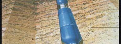
34 Core Sampling for Migration Pathway Identification cored hole rock core TCE mg/l fractures core samples analyzed non-detect Fractures with TCE migration B.L. Parker, 2000


35 Rock Core VOC Profiles show Transport in Many Fractures VOC Pathways VOC Pathways Overburden Flow zones identified by borehole flow testing
36 Resulting Velocity Profile from FLUTe TM Liner Installation


37 Watervliet FLUTe Transmissivity & Geophysical Profiles at IW-1 ft bgs) Depth (f flow zones identified by BH flow testing
38 DNAPL Serves as a Tracer for Many Hydraulically Active Fractures
39 Alternative Conceptual Model: Lots of Interconnected Fractures FRACTRAN Example: Well-Interconnected t Fracture Network


40 Depth Discrete Multilevel Systems Solinst FLUTe Westbay


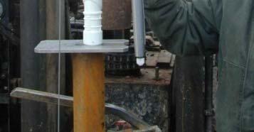
41 FLUTe Multilevel System (Temporary Monitoring during Initial Injections) Installation & K-Profiling N 2 tank 5 holes, 150-ft deep IW-1 toiw-4 IW-4, MW-79 9 ports each Sampling manifold


42 Full-Scale NaMnO 4 Injections Carus Chemical Co. NaMnO 4 (40wt%) 500 gal Mixing / Injection Tank Double diaphragm Pump Gravity and low pressure (10-15psi) injection Injection Summary Well-head Seal / Vent

 0")


43 MW-79 Inj#3a Depth (ft bgs) 0 MW-79 IW-1 to IW-4 20 port packer ft 85 ft 120 ft 80 ft 160
44 MnO 4 Distribution in FLUTe Multilevels May 2005: End of MW-79 Inj#3a Distance from MW-79 (ft) MW-79 packer
45 Comparison: Extent of MnO 4 versus Elevated Sulfate SO 4 SO 4 SO 4 SO 4 Elevated sulfate more widespread; MnO 4 consumed before reaching ports Well interconnected fracture network
46 Key Point: Numerous Interconnected Fractured Evident at this Site Dense Network Sparse p Network
47 Key Point Permanganate was delivered throughout the contaminated zone because of numerous, interconnected active fractures
48 Implications for Well-Interconnected Fracture Network vs. Super Highway Influences: ~ Where and how best to Monitor ~ Predictions of contaminant transport and fate ~ Adequacy of Insitu remediation system designs ~ Accuracy of system performance assessments Note: mass persists in lower permeability zones
49 Conclusions Plumes in fractured sedimentary rock are strongly retarded d and attenuated t due to dispersion, diffusion and sorption St t d ti i Strong retardation requires numerous, interconnected fractures that are evident using new DFN investigation methods
50 Acknowledgements Canadian NSERC Industrial Research Chair: Groundwater Contamination in Fractured Media 14 Corporate sponsors: Site Owners, Municipalities, Technology Companies UoG Research Team: John Cherry, Steve Chapman, Jessi Meyer, Pete Pehme, Amanda Pierce, Paulo Lima, Glaucia Lima, Jonathan Kennel and Ryan Kroeker, Maria Gorecka, Rashmi Jaheda Academic Collaborators: Aravena, Al, Balcom, Molson, Gorecki, Borchardt, Mayer, Hatfield 18 graduate students ( present)
51 Appreciation Muito obrigada à comissão organizadora do evento pelo convite feito a mim para essa apresentação e a todos da audiência pela atenção. Sendo minha primeira visita ao Brasil, sinto-me honrada em poder falar com vocês hoje. Perguntas? Thank you very much to the event s organizing committee for the invitation to give this talk and to the audience for your attention. Being my first visit to Brazil, I am honoured in talking to you today. Questions?
52 The End
53
54
55 Approach: Combination of Old and New Methods Standard d (open borehole): Borehole geophysics Straddle packer testing Flow metering New (lined borehole): FLUTe K profiling / hole sealing Temperature profiling in lined hole High resolution multilevel systems focused on aquifer-aquitard aquitard issues
56 Summary Groundwater velocities in fractured rock are very fast Some contaminants can be strongly retarded and attenuated, but depends on rock and contaminant properties Bedrock aquifers and aquitards require high-resolution characterization for improved prediction and decisionmaking DFN Field Approach
57 Nature of Contamination in Fractured Sedimentary Rock Requires a Different Approach vadose zone SOURCE ZONE PLUME ZONE groundwater zone PLUME FRONT
58 Studies of Contaminants in Sedimentary Rocks Offer the Advantage of Diffusion Halos Sedimentary Rock Granite
59 Contamination in Fractured Non-Porous Media (FNPM)


60 Contamination in Fractured Porous Media (FPM)
61 Contamination in Granular Porous Media (GPM)
62 Terminology ogy GPM Granular Porous Media FNPM Fractured Non-Porous Media FPM Fractured Porous Media DFN Approach is Crucial for Time of Travel
63 DNAPL Phase Initially Resides within Fractures Fracture Aperture 2b φ f H 2 O φ m DNAPL φ m Matrix porosity is 1000 times greater than fracture porosity Fracture Spacing
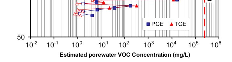
64 DNAPL Disappearance from Fractures by Diffusion Parker et al., Ground Water (1994) Fracture Aperture 2b φ f φ m 2 φ f φ φ f m H O DNAPL φ m Dissolved Fracture Dissolved Phase Spacing Phase Early Intermediate Later Time


65 Terminology ogy GPM Granular Porous Media FNPM Fractured Non-Porous Media FPM Fractured Porous Media DFN Approach is Crucial for Time of Travel
66 Diffusion Into Rock Matrix Porous Rock Matrix Fracture Diffusioni Halo
67 Fick s First Law C J = -φ D D m e x w
68 Stylistic Comparison of Contaminant Profiles C/C o core vert8t.pre C t i t 50 C t t S Contaminant 50 years: Constant Source Well-Connected Fracture Network
69 Core Hole for Rock Core Analyses in Areas of Previous DNAPL Occurrence cored hole vadose zone groundwater zone


70 Wire-line Core Barrel
71 Stylistic Similarity of Field and Model Field Profile 35B TCE (mg/l) Model at X=70m; 50 years 50 TCE (mg/l) Depth (m bgs) Z (m) Note: Assumed TCE solubility = 1400 mg/l to convert model C/Co to mg/l


72 Watervliet FLUTe Transmissivity & Geophysical Profiles at IW-1 flow zones identified by BH flow testing gs) Depth (ft bg
73 PCE and Degradation Products in Groundwater South North Discrete Interval sampling ( ) TCE PCE cis-dce TD = 160 ft bgs
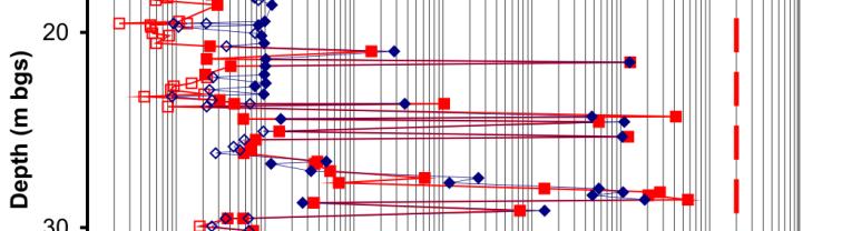
74 Hydraulic Head and VOCs CMT Multilevel MW Head (m AMSL) CMT MW-75 [VOC] (μg/l) CMT MW-75 PCE TCE CMT Layout cis-dce VC 1 Depth (m bgs) /02/ /05/ /25/
75 Key Points: VOCs in Groundwater VOCs present in nearly all sample intervals Large concentrations deep (> 50m) despite upward hydraulic gradients DNAPL penetration and transport in well- interconnected fracture network
76 Any Given Borehole Gives Only a Few Large Transmissive Fractures FRACTRAN Example: dense fracture network
77 Guelph Formation Dolostone in Nearby Outcrops


78 Investigate Plume Characteristics and Behavior Using Transect G5 TCE P15 P9 P10 P11 P17 UW16B UW13 Syngenta Field Site Metolachlor G m G17 G18
79 Multilevels in UW Coreholes along West-East Cross-Section UW5 UW13 OW13 UW6 OW13-BR 330 W E 310 OW24 UW4 OW42 OW9 UW3 290 Overburden (masl) El levation TCE and Metolachlor Plume Sampling Port Dolostone Aquifer Shale Pressure Transducer & Sampling Port Distance (m) 320


80 Fractured Porous Rocks Bedding planes and joints in dolostone Sandstone with shale interbeds Interbedded sandstone and shale


81 Hydrogeology ogy Terminology ogy GPM Granular Porous Medium sands & gravels Karst Conduit some limestones & dolostones FNPM Fractured Non-Porous Medium granites FPM Fractured Porous Medium sandstone shale mudstones clays,silts


82 Distribution of Sedimentary Rocks in North America Sedimentary bedrock Igneous, volcanic, and metamorphic bedrock Source: Heath, 1988


83 Nearly all people and industry reside in areas overlying sedimentary bedrock Igneous, volcanic, and metamorphic bedrock Sedimentary bedrock with most of population Population year 2000
84 What do we know about fracture networks? Photos (outcrop, borehole image, core logs)
85 Orthogonal Fracture Sets in Sandstone California i Site


86 FLUTe liner pressed tightly against borehole wall to seal without liner with liner


87
88 MW-25 between 9 and 12 mbgs d Doloston e Guelph Formation Mti Matrix Porosity (1-20%) MW-25 between 73 and 76 mbgs Amabel Formation
A High Resolution Vertical Gradient Approach for Delineation of Hydrogeologic Units at a Contaminated Sedimentary Rock Field Site
 A High Resolution Vertical Gradient Approach for Delineation of Hydrogeologic Units at a Contaminated Sedimentary Rock Field Site Jessica Meyer 2013 - Solinst Symposium High Resolution, Depth-Discrete
Use of Tracer Dyes to Understand Fractured Bedrock Flow during a Pumping Test
 Use of Tracer Dyes to Understand Fractured Bedrock Flow during a Pumping Test 2015 NGWA Conference on Groundwater in Fractured Rock Presenter: Bette Nowack, PE, Stone Environmental Co-Authors: Andrew Fuller,
1. The Discrete Fracture Network (DFN) Approach for Contaminated Bedrock Site Characterization
 Approach for Contaminated Bedrock Site Characterization") 1. The Discrete Fracture Network (DFN) Approach for Contaminated Bedrock Site Characterization Beth L. Parker and John A. Cherry April 2011 Center for Applied Groundwater Research University of Guelph
1. The Discrete Fracture Network (DFN) Approach for Contaminated Bedrock Site Characterization Beth L. Parker and John A. Cherry April 2011 Center for Applied Groundwater Research University of Guelph
Hydraulic and Water-Quality Characterization of Fractured-Rock Aquifers Using Borehole Geophysics
 Hydraulic and Water-Quality Characterization of Fractured-Rock Aquifers Using Borehole Geophysics John H. Williams Office of Ground Water Troy, New York Flow in Open Borehole Runkel and others (2003) Ambient
The use of straddle packer testing to hydraulically characterize rock boreholes for contaminant transport studies
 The use of straddle packer testing to hydraulically characterize rock boreholes for contaminant transport studies Patryk Quinn, John Cherry, Beth Parker Presentation for the Solinst Symposium November
FRACTURED ROCK Characterization and Remediation. Allan Horneman September 30, 2016
 FRACTURED ROCK Characterization and Remediation Allan Horneman September 30, 2016 Disclaimers and Notices The materials herein are intended to furnish viewers with a summary and overview of general information
BOS 100 Overburden and Bedrock Groundwater Remediation Former Dry Cleaning Facility
 BOS 100 Overburden and Bedrock Groundwater Remediation Former Dry Cleaning Facility Site Description Location Central Kentucky Site Use Retail Shopping Center Geologic Setting Inner Bluegrass Bedrock Ordovician
Groundwater. (x 1000 km 3 /y) Reservoirs. Oceans Cover >70% of Surface. Groundwater and the. Hydrologic Cycle
 Reservoirs. Oceans Cover >70% of Surface. Groundwater and the. Hydrologic Cycle") Chapter 13 Oceans Cover >70% of Surface Groundwater and the Hydrologic Cycle Oceans are only 0.025% of Mass Groundwater Groundwater is liquid water that lies in the subsurface in fractures in rocks and
Chapter 13 Oceans Cover >70% of Surface Groundwater and the Hydrologic Cycle Oceans are only 0.025% of Mass Groundwater Groundwater is liquid water that lies in the subsurface in fractures in rocks and
DNAPL migration through interbedded clay-sand sequences
 Groundwater Quality: Natural and Enhanced Restoration of Groundwater Pollution (Proceedings ofthe Groundwater Quality 2001 Conference held al Sheffield. UK. June 2001). IAHS Publ. no. 275. 2002. 455 DNAPL
February 22, 2011 Picatinny Team Meeting Edison, New Jersey
 February 22, 2011 Picatinny Team Meeting Edison, New Jersey Updated Groundwater Model and Remedies Mid-Valley Groundwater (PICA 204) February 22, 2011 Imagine the result Review of 2009 2010 Field Program
Groundwater. (x 1000 km 3 /y) Oceans Cover >70% of Surface. Groundwater and the. Hydrologic Cycle
 Oceans Cover >70% of Surface. Groundwater and the. Hydrologic Cycle") Chapter 17 Oceans Cover >70% of Surface Groundwater and the Hydrologic Cycle Vasey s Paradise, GCNP Oceans are only 0.025% of Mass Groundwater Groundwater is liquid water that lies in the subsurface in
Chapter 17 Oceans Cover >70% of Surface Groundwater and the Hydrologic Cycle Vasey s Paradise, GCNP Oceans are only 0.025% of Mass Groundwater Groundwater is liquid water that lies in the subsurface in
INNOVATIVE TECHNIQUES TO INVESTIGATE CONTAMINATION IN FRACTURED BEDROCK
 INNOVATIVE TECHNIQUES TO INVESTIGATE CONTAMINATION IN FRACTURED BEDROCK Abstract Christopher Gaule 1, Kenneth Goldstein 2, Grant Anderson 3 Watervliet Arsenal, located in Watervliet, New York, is the oldest
Assessing the Tier 2 Trigger for Fractured Sedimentary Bedrock Sites
 Assessing the Tier 2 Trigger for Fractured Sedimentary Bedrock Sites Ken Lyon, Jennifer Arnold, Louise Burden Advisian WorleyParsons Group RemTech 2015, October 16, Banff, AB INTRODUCTION High level look
David de Courcy-Bower and Samuel Mohr
 Applicability and Limitations of LNAPL Transmissivity as a Metric within Bedrock Formations Insert then choose Picture select your picture. Right click your picture and Send to back. David de Courcy-Bower
Aquitard Characterization The Legend of Indiana s Magic Clay Layer. Juliet Port, LPG #2214 July 2014
 Aquitard Characterization The Legend of Indiana s Magic Clay Layer Juliet Port, LPG #2214 July 2014 Topics What is an Aquitard? Why do we care? Review of Indiana glacial geology Conceptual Framework Investigation
The Potential for Compromised Interpretations When Based on Open Borehole Geophysical Data in Fractured Rock.
 The Potential for Compromised Interpretations When Based on Open Borehole Geophysical Data in Fractured Rock. Peeter Pehme *,1,2, Beth Parker 1,3, John A. Cherry 1, and John P. Greenhouse 2 It has long
DRAFT SITE CONCEPTUAL MODEL FOR THE MIGRATION AND FATE OF CONTAMINANTS IN GROUNDWATER AT THE SANTA SUSANA FIELD LABORATORY, SIMI, CALIFORNIA
 DRAFT SITE CONCEPTUAL MODEL FOR THE MIGRATION AND FATE OF CONTAMINANTS IN GROUNDWATER AT THE SANTA SUSANA FIELD LABORATORY, SIMI, CALIFORNIA OVERVIEW AND 20 SITE CONCEPTUAL MODEL ELEMENTS VOLUME 1 OF 4
Differentiation of chloride source using stable chlorine isotopes
 Differentiation of chloride source using stable chlorine isotopes RemTech 2009 Banff, Alberta October 14-16 2009 Dr. Alec Blyth and Tom Anthony 1 1 currently City of Calgary Background: DOW Chemical Canada
Optimization of In-Situ Chemical Oxidation Design Parameters
 Optimization of In-Situ Chemical Oxidation Design Parameters by Amine Dahmani, PhD Director, Site Assessment & Remediation Laboratories Ken Huang, PhD Remediation Laboratory Manager Environmental Research
A Short Course in Contaminated Fractured Rock Hydrogeology and Geophysics
 A Short Course in Contaminated Fractured Rock Hydrogeology and Geophysics An Eight Hour Geophysics Course Offered Through the Environmental Professionals' Organization of Connecticut Date: Nov 19, Nov
Deep Borehole Disposal Performance Assessment and Criteria for Site Selection
 Deep Borehole Disposal Performance Assessment and Criteria for Site Selection Sandia is a multiprogram laboratory operated by Sandia Corporation, a Lockheed Martin Company, for the United States Department
Evaluation of an Oxygen Injection Technology for In-Situ Hydrocarbon Bioremediation in a Fractured Bedrock Environment
 Evaluation of an Oxygen Injection Technology for In-Situ Hydrocarbon Bioremediation in a Fractured Bedrock Environment Karen D. Greer 1,2 1 WESA Inc. Kitchener, Ontario, Canada J. Barker 2, J. Molson 2,3,
11/22/2010. Groundwater in Unconsolidated Deposits. Alluvial (fluvial) deposits. - consist of gravel, sand, silt and clay
 deposits. - consist of gravel, sand, silt and clay") Groundwater in Unconsolidated Deposits Alluvial (fluvial) deposits - consist of gravel, sand, silt and clay - laid down by physical processes in rivers and flood plains - major sources for water supplies
Groundwater in Unconsolidated Deposits Alluvial (fluvial) deposits - consist of gravel, sand, silt and clay - laid down by physical processes in rivers and flood plains - major sources for water supplies
Bedrock Characterization Mottolo Pig Farm Superfund Site
 Bedrock Characterization Mottolo Pig Farm Superfund Site Andrew Drew Hoffman, PE NH Department of Environmental Services andrew.hoffman@des.nh.gov 603.271.6778 1 Acknowledgments GZA GeoEnvironmental (lead
Investigation of the Impact of Fracture Intersection on Solute Transport in Fractured Carbonate. Abstract. 2. Site description
 Investigation of the Impact of Fracture Intersection on Solute Transport in Fractured Carbonate Catherine Ledoux, Département de géologie et génie géologique, Université Laval, Québec, Canada René Therrien,
Essentials of Geology, 11e
 Essentials of Geology, 11e Groundwater Chapter 10 Instructor Jennifer Barson Spokane Falls Community College Geology 101 Stanley Hatfield Southwestern Illinois Co Jennifer Cole Northeastern University
Case Study: University of Connecticut (UConn) Landfill
 Landfill") Case Study: University of Connecticut (UConn) Landfill Problem Statement:» Locate disposal trenches» Identify geologic features and distinguish them from leachate and locate preferential pathways in fractured
Case Study: University of Connecticut (UConn) Landfill Problem Statement:» Locate disposal trenches» Identify geologic features and distinguish them from leachate and locate preferential pathways in fractured
Autopsy of a Small UST site in Bedrock: Case Study, Devens, MA
 Autopsy of a Small UST site in Bedrock: Implications for ISCO Effectiveness Case Study, Devens, MA William C. Brandon, Hydrogeologist, US EPA Region 1 NEWMOA ISCO WORKSHOP Westford Regency Westford, MA
A Risk-based Groundwater Modelling Study for Predicting Thermal Plume Migration from SAGD Well-pads
 A Risk-based Groundwater Modelling Study for Predicting Thermal Plume Migration from SAGD Well-pads Rudy Maji, Ph.D., Golder Associates Solaleh Khezri, M.Sc., AB Scientific Intern (Golder Associates) Don
Understanding Subsurface Fate & Transport
 Back-to-Basics Part 1: Developing the CSM & Site Characterization Understanding Subsurface Fate & Transport Understanding Subsurface Fate & Transport Purpose: To provide an introduction to the basics of
Appendix D Fractured Rock Appendix
 Appendix D Fractured Rock Appendix 1.0 Introduction The behavior of LNAPL in fractured bedrock is not necessarily intuitive and is not as easily described using the principles and techniques adopted for
Hydrogeology of Karst NE Wisconsin. Dr. Maureen A. Muldoon UW-Oshkosh Geology Department
 Hydrogeology of Karst NE Wisconsin Dr. Maureen A. Muldoon UW-Oshkosh Geology Department WI Bedrock Outline Karst Landscapes Existing WQ Data Flow in Karst Aquifers Overview of Silurian Aquifer Water Level
Geophysical Exploration in Water Resources Assessment. John Mundell, P.E., L.P.G., P.G. Ryan Brumbaugh, L.P.G. Mundell & Associates, Inc.
 Geophysical Exploration in Water Resources Assessment John Mundell, P.E., L.P.G., P.G. Ryan Brumbaugh, L.P.G. Mundell & Associates, Inc. Presentation Objective Introduce the use of geophysical survey methods
April 27, Ground Water in Kingwood Township
 KINGWOOD TOWNSHIP ENVIRONMENTAL COMMITTEE April 27, 2010 Ground Water in Kingwood Township Gail Ashley Debbie Kratzer Information source, unless otherwise noted: Environmental Resource Inventory for Kingwood
Groundwater in Bedrock Aquifers: Development Considerations
 Slide 1 Groundwater in Bedrock Aquifers: Development Considerations Pelham, New Hampshire October 3, 2016 Building Trust. Engineering Success. Slide 2 OUTLINE Background on groundwater in bedrock aquifers
FORENSIC GEOLOGY A CIVIL ACTION
 NAME 89.215 - FORENSIC GEOLOGY A CIVIL ACTION I. Introduction In 1982 a lawsuit was filed on behalf of eight Woburn families by Jan Schlictmann. The suit alleged that serious health effects (childhood
Wisconsin s Hydrogeology: an overview
 2012 Soil and Water Conservation Society Conference Stevens Point, WI Feb 9, 2012 Wisconsin s Hydrogeology: an overview Ken Bradbury Wisconsin Geological and Natural History Survey University of Wisconsin-Extension
Western Kentucky CO 2 Storage Test
 Western Kentucky CO 2 Storage Test Principal Investigators: Rick Bowersox - Lexington Dave Williams - Henderson KGS First Friday Seminar Lexington, Kentucky March 4, 2011 The project proceeded in two phases:
Harvey Thorleifson, Director, Minnesota Geological Survey. Status of geological mapping needed for groundwater protection in Minnesota
 Harvey Thorleifson, Director, Minnesota Geological Survey Status of geological mapping needed for groundwater protection in Minnesota Minnesota is located between the Dakotas and Wisconsin, north of Iowa,
Regional groundwater mapping and model
 Regional groundwater mapping and model Boyd, Dwight 1, Steve Holysh 2, and Jeff Pitcher 1 1 Grand River Conservation Authority, Canada; 2 Regional Municipality of Halton, Canada The Grand River forms one
CHARACTERIZATION OF A FRACTURED AQUIFER USING THE COLLOIDAL BORESCOPE
 CHARACTERIZATION OF A FRACTURED AQUIFER USING THE COLLOIDAL BORESCOPE PETER M. KEARL 1,, KIRK ROEMER 2, *, ERIC B. ROGOFF 3 AND RICHARD M. RENN 3 1 AquaVISION 375 33½ Road, Palisade, CO 81526 2 Life Sciences
Soils, Hydrogeology, and Aquifer Properties. Philip B. Bedient 2006 Rice University
 Soils, Hydrogeology, and Aquifer Properties Philip B. Bedient 2006 Rice University Charbeneau, 2000. Basin Hydrologic Cycle Global Water Supply Distribution 3% of earth s water is fresh - 97% oceans 1%
HYDROGEOLOGICAL PROPERTIES OF THE UG2 PYROXENITE AQUIFERS OF THE BUSHVELD COMPLEX
 R. Gebrekristos, P.Cheshire HYDROGEOLOGICAL PROPERTIES OF THE UG2 PYROXENITE AQUIFERS OF THE BUSHVELD COMPLEX R. Gebrekristos Digby Wells Environmental P. Cheshire Groundwater Monitoring Services Abstract
WaterTech 2017 April 4, 2017
 Haskayne Master Drainage Plan: Hydraulic Relationships Between Groundwater Flow Systems and the Bearspaw Reservoir and Potential for Stormwater Disposal, City of Calgary WaterTech 2017 April 4, 2017 Project
Prof. Stephen A. Nelson EENS 111. Groundwater
 Page 1 of 8 Prof. Stephen A. Nelson EENS 111 Tulane University Physical Geology This page last updated on 20-Oct-2003 is water that exists in the pore spaces and fractures in rock and sediment beneath
1.72, Groundwater Hydrology Prof. Charles Harvey Lecture Packet #5: Groundwater Flow Patterns. Local Flow System. Intermediate Flow System
 1.72, Groundwater Hydrology Prof. Charles Harvey Lecture Packet #5: Groundwater Flow Patterns c Local Flow System 10,000 feet Intermediate Flow System Regional Flow System 20,000 feet Hydrologic section
Chapter 13. Groundwater
 Chapter 13 Groundwater Introduction Groundwater is all subsurface water that completely fills the pores and other open spaces in rocks, sediments, and soil. Groundwater is responsible for forming beautiful
10. GEOTECHNICAL EXPLORATION PROGRAM
 Geotechnical site investigations should be conducted in multiple phases to obtain data for use during the planning and design of the tunnel system. Geotechnical investigations typically are performed in
The mountain is permeable and fractured: Hydrological Connectivity in the Laramie Range
 WyCHEG Interest Group Meeting, Oct 30, 2017, Laramie, WY The mountain is permeable and fractured: Hydrological Connectivity in the Laramie Range Ye Zhang 1, Brad Carr 1, Shuangpo Ren 2, Andy Parsekian
FRACTURE TRACES AND PRODUCTIVITY OF MUNICIPAL WELLS IN THE MADISON LIMESTONE, RAPID CITY, SOUTH DAKOTA
 Proceedings of the South Dakota Academy of Science, Vol. 87 (2008) 261 FRACTURE TRACES AND PRODUCTIVITY OF MUNICIPAL WELLS IN THE MADISON LIMESTONE, RAPID CITY, SOUTH DAKOTA Perry H. Rahn Department of
Groundwater Hydrology
 EXERCISE 12 Groundwater Hydrology INTRODUCTION Groundwater is an important component of the hydrologic cycle. It feeds lakes, rivers, wetlands, and reservoirs; it supplies water for domestic, municipal,
Buried Bedrock Channels in the Athabasca Oil Sands Region Conceptual Understanding and Implications to Water Supply
 Buried Bedrock Channels in the Athabasca Oil Sands Region Conceptual Understanding and Implications to Water Supply Scott Rayner Matrix Solutions Inc. Sandra Rosenthal Devon Canada Corporation Presentation
GEOLOGY AND MINERAL RESOURCES OF INDIAN RESERVE 26
 ) 41HI3NW94I4 I R NO 26 1*A1 MANITOULIN ISLAND 010 -f?;. GEOLOGY AND MINERAL RESOURCES OF INDIAN RESERVE 26 September 16, 1975 D. G. Innes, Resident Geologist Sudbury District Ministry of Natural Resources
THE MARCELLUS SHALE GAS PLAY Geology, Development, and Water-Resource Impact Mitigation
 THE MARCELLUS SHALE GAS PLAY Geology, Development, and Water-Resource Impact Mitigation John H. Williams New York Water Science Center Troy, New York https://profile.usgs.gov/jhwillia/ Marcellus shale
Water Framework Directive. Groundwater Monitoring Programme. Site Information. Kiltrough PWS
 Water Framework Directive Groundwater Monitoring Programme Site Information Kiltrough PWS ImagePath1: Kiltrough PWS\17_009_Kiltough_P1_SiteLo cation.jpg This monitoring point is a well that is part of
Geologic Considerations of Shallow SAGD Caprock; Seal Capacity, Seal Geometry and Seal Integrity, Athabasca Oilsands, Alberta Canada
 Geologic Considerations of Shallow SAGD Caprock; Seal Capacity, Seal Geometry and Seal Integrity, Athabasca Oilsands, Alberta Canada Gordon T. Stabb, Michael Webb Durando Resources Corp, Suncor Energy
How Can We Sustain Groundwater Quality in Karst and Fracturedcarbonate. Maureen A. Muldoon Geology Department Univ. Of Wisconsin-Oshkosh
 How Can We Sustain Groundwater Quality in Karst and Fracturedcarbonate Aquifers? Maureen A. Muldoon Geology Department Univ. Of Wisconsin-Oshkosh The Question Karst and fracturedcarbonates form productive,
Pressure Grouting of Fractured Bedrock to Control Acid Mine Drainage
 WATER RESOURCES AT RISK May 14-18, 1995 Denver American Institute of Hydrology Pressure Grouting of Fractured Bedrock to Control Acid Mine Drainage S. A. Effner, G. D. Vandersluis, and V. Straskraba Hydro-Geo
A. Baiocchi 1, W. Dragoni 2, F. Lotti 1, S.M. Piacentini 2, V. Piscopo 1
 A. Baiocchi 1, W. Dragoni 2, F. Lotti 1, S.M. Piacentini 2, V. Piscopo 1 (1) Department of Ecological and Biological Sciences, University of Tuscia, Viterbo, Italy (2) Department of Physics and Geology,
Control of Fractured Bedrock Structure on the Movement of Chlorinated Volatile Organics in Bedrock and Overburden Aquifers, Newark Basin of New Jersey
 Control of Fractured Bedrock Structure on the Movement of Chlorinated Volatile Organics in Bedrock and Overburden Aquifers, Newark Basin of New Jersey Robert M. Bond, PG and Katherine E. Linnell, PG, Langan
Karst Topography In order to understand karst topography we must first have a basic understanding of the water cycle, the formation of limestone (carb
 Karst Topography The formation of caves and other associated features in limestone bedrock is called karst topography. Limestone, a sedimentary rock made mostly of the mineral calcite and small amounts
First Field Test of NAPL Detection with High Resolution Borehole Seismic Imaging
 1 First Field Test of NAPL Detection with High Resolution Borehole Seismic Imaging Jil T. Geller, John E. Peterson, Kenneth H. Williams, Jonathan B. Ajo!Franklin*, and Ernest L. Majer Earth Sciences Division,
Key factors for a successful ISCO application with Permanganate
 Key factors for a successful ISCO application with Permanganate Prepared by: Richard W Lewis CPG Program Manager ERM 1, 11/22/2002 1 1 ISCO Treatment Two key issues Does the reaction take place? Competing
RADIONUCLIDE DIFFUSION IN GEOLOGICAL MEDIA
 GEOPHYSICS RADIONUCLIDE DIFFUSION IN GEOLOGICAL MEDIA C. BUCUR 1, M. OLTEANU 1, M. PAVELESCU 2 1 Institute for Nuclear Research, Pitesti, Romania, crina.bucur@scn.ro 2 Academy of Scientists Bucharest,
The Niagara Escarpment extends from western New York, through the GTA all the way up to Manitoulin Island and into Michigan and Wisconsin.
 is southern Ontario s most prominent topographic feature, extending more than 500 kilometres from western New York, through Niagara Falls and the western part of the Greater Toronto Area (GTA), and north
ENVIRONMENTAL RESTORATION
 ENVIRONMENTAL RESTORATION Site Characterization and Remediation in Fractured Rock Introduction Site characterization and remediation in fractured rock affords a unique set of challenges not typically associated
Lecture 16 Groundwater:
 Reading: Ch 6 Lecture 16 Groundwater: Today 1. Groundwater basics 2. inert tracers/dispersion 3. non-inert chemicals in the subsurface generic 4. non-inert chemicals in the subsurface inorganic ions Next
Karst Assessment. March Prepared by: S.R.H. Worthington NWMO DGR-TR
 Karst Assessment March 2011 Prepared by: S.R.H. Worthington NWMO DGR-TR-2011-22 Karst Assessment March 2011 Prepared by: S.R.H. Worthington NWMO DGR-TR-2011-22 Karst Assessment - ii - March 2011 THIS
The Geology and Hydrogeology of the Spyhill Area
 The Geology and Hydrogeology of the Spyhill Area Clare North (WorleyParsons Komex) and Martin Ortiz (The City of Calgary) 2-Jul-08 Outline Background Site Location Existing Information New Work Geology
Michigan s Geology and Groundwater
 Michigan s Geology and Groundwater Ralph J. Haefner Deputy Director U.S. Geological Survey Michigan-Ohio Water Science Center Lansing, Michigan Outline About the USGS Geology 101 Michigan s geology Bedrock
Lab 9: Petroleum and groundwater
 Geology 101 Name(s): Lab 9: Petroleum and groundwater Petroleum (oil) is a multi-component liquid refined to generate different hydrocarbons, such as heptane (a component of gasoline) and waxes. For the
Hydrologic and Borehole Geophysical Investigation of Bedrock Observation Wells at the University of Maine
 Hydrologic and Borehole Geophysical Investigation of Bedrock Observation Wells at the University of Maine Abstract Eric Rickert, Andrew Reeve, Frederick L. Paillet, University of Maine The University of
 12 10 8 6 4 2 0 40-50 50-60 60-70 70-80 80-90 90-100 Fresh Water What we will cover The Hydrologic Cycle River systems Floods Groundwater Caves and Karst Topography Hot springs Distribution of water in
CHEMICAL OXIDATION TECHNIQUES FOR THE IN SITU REMEDIATION OF HYDROCARBON IMPACTED SOILS
 CHEMICAL OXIDATION TECHNIQUES FOR THE IN SITU REMEDIATION OF HYDROCARBON IMPACTED SOILS Cheryl Kluck and Gopal Achari Center for Environmental Engineering Research and Education (CEERE) University of Calgary
Postclosure Safety Assessment: Groundwater Modelling
 Postclosure Safety Assessment: Groundwater Modelling March 2011 Prepared by: Geofirma Engineering Ltd. NWMO DGR-TR-2011-30 Postclosure Safety Assessment: Groundwater Modelling March 2011 Prepared by:
Delineation of Zones at Risk from Groundwater Inflows at an Underground Platinum Mine in South Africa
 Delineation of Zones at Risk from Groundwater Inflows at an Underground Platinum Mine in South Africa Mr Andreas Stoll andreas.stoll@erm.com Environmental Resources Management Swiss GmbH (ERM), Switzerland
HYDRAULIC CONDUCTIVITY AND SPECIFIC STORAGE OF THE MAQUOKETA SHALE
 HYDRAULIC CONDUCTIVITY AND SPECIFIC STORAGE OF THE MAQUOKETA SHALE A Final Report prepared for the UNIVERSITY OF WISCONSIN WATER RESOURCES INSTITUTE Prepared by Timothy T. Eaton 1,2 David J. Hart 2 Kenneth
GEOL.3250 Geology for Engineers Glacial Geology
 GEOL.3250 Geology for Engineers Glacial Geology NAME Part I: Continental Glaciation Continental glaciers are large ice sheets that cover substantial portions of the land area. In the region of accumulation
L-31N Seepage Management Field Test
 Miami-Dade Limestone Products Association 13292 N.W. 118 th Avenue Miami, FL 33178 L-31N Seepage Management Field Test The Performance of a Partially Penetrating Seepage Barrier along the L-31N Canal July
Gotechnical Investigations and Sampling
 Gotechnical Investigations and Sampling Amit Prashant Indian Institute of Technology Gandhinagar Short Course on Geotechnical Investigations for Structural Engineering 12 14 October, 2017 1 Purpose of
Site investigation results versus tunnelling conditions a study with emphasis on water leakage based on Norwegian cases
 Site investigation results versus tunnelling conditions a study with emphasis on water leakage based on Norwegian cases Kristin H. Holmøy, Bjørn Nilsen Norwegian University of Science and Technology, Department
Cappog Bridge (PW-3)
") Water Framework Directive Groundwater Monitoring Programme Site Information Cappog Bridge (PW-3) ImagePath1: Cappog Bridge\IEGBNI_NB_G_012_18_0 01_A_SiteLocation.jpg Cappog Bridge PW-3 is one of 8 boreholes
Water Framework Directive Groundwater Monitoring Programme Site Information Cappog Bridge (PW-3) ImagePath1: Cappog Bridge\IEGBNI_NB_G_012_18_0 01_A_SiteLocation.jpg Cappog Bridge PW-3 is one of 8 boreholes
Monitoring of In-Situ Chemical Oxidation (ISCO) with Time Series Geophysical Surveys
 with Time Series Geophysical Surveys") Monitoring of In-Situ Chemical Oxidation (ISCO) with Time Series Geophysical Surveys Philip T. Harte, P.G. U.S. Geological Survey ptharte@usgs.gov 603-226-7813 U.S. Department of the Interior U.S. Geological
Monitoring of In-Situ Chemical Oxidation (ISCO) with Time Series Geophysical Surveys Philip T. Harte, P.G. U.S. Geological Survey ptharte@usgs.gov 603-226-7813 U.S. Department of the Interior U.S. Geological
PART I Hot Dry Rock Geothermal Energy: History and Potential of the Newest and Largest Renewable Energy Resource
 Contents PART I Hot Dry Rock Geothermal Energy: History and Potential of the Newest and Largest Renewable Energy Resource Chapter 1 Serendipity A Brief History of Events Leading to the Hot Dry Rock Geothermal
Finding Large Capacity Groundwater Supplies for Irrigation
 Finding Large Capacity Groundwater Supplies for Irrigation December 14, 2012 Presented by: Michael L. Chapman, Jr., PG Irrigation Well Site Evaluation Background Investigation Identify Hydrogeologic Conditions
In-Situ Thermal Treatment of Fractured Rock
 In-Situ Thermal Treatment of Fractured Rock Ralph S. Baker, Ph.D. Chairman and Chief Scientist Gorm Heron, Ph.D. Chief Technology Officer TerraTherm, Inc. About TerraTherm, Inc. TCH at a recently completed
Dunkerrin - Guilfoyles Well
 Water Framework Directive Groundwater Monitoring Programme Site Information Dunkerrin - Guilfoyles Well ImagePath1: Dunkerrin - Guilfoyles Well\IE_SH_G_19_005_a_Pump House_(800_x_600).jpg Dunkerrin/ Guilfoyles
WESTCARB Phase I Results Review
 WESTCARB Phase I Results Review Arizona Geologic Characterization Errol Montgomery Principal Errol L. Montgomery & Associates (520) 881-4912 emontgomery@elmontgomery.com November 9, 2005 Site Characterization
Drilling And Testing in the Deep Borehole Field Test
 Photos placed in horizontal position with even amount of white space between photos and header Drilling And Testing in the Deep Borehole Field Test Kristopher L. Kuhlman, David C. Sassani, Geoff A. Freeze,
Preliminary Conceptual Models Of Chlorinated-Solvent Accumulation in Karst Aquifers
 Preliminary Conceptual Models Of Chlorinated-Solvent Accumulation in Karst Aquifers By William J. Wolfe and Connor J. Haugh U.S. Geological Survey, 640 Grassmere Park, Suite 100, Nashville, TN 37211 Abstract
Economic Geology Unconventional Energy Research
 Bureau of Economic Geology Unconventional Energy Research Overview for CEE meeting December, 2011 QAd2349x BUREAU OF ECONOMIC GEOLOGY Oldest research unit of The University of Texas at Austin Geological
Geology 228/378 Applied and Environmental Geophysics Lecture 6. DC resistivity Surveys
 Geology 228/378 Applied and Environmental Geophysics Lecture 6 DC resistivity Surveys Direct current (DC) Resistivity. Introduction 2. Current flow in the ground 3. Schlumberger, Wenner, dipole-dipole,
WAMUNYU EDWARD MUREITHI I13/2358/2007
 WAMUNYU EDWARD MUREITHI I13/2358/2007 Olkaria geothermal area is situated south of Lake Naivasha on the floor of the southern segment of the Kenya rift. The geology of the Olkaria Geothermal area is subdivided
Instructional Objectives
 GE 6477 DISCONTINUOUS ROCK 8. Fracture Detection Dr. Norbert H. Maerz Missouri University of Science and Technology (573) 341-6714 norbert@mst.edu Instructional Objectives 1. List the advantages and disadvantages
Chemical Hydrogeology
 Physical hydrogeology: study of movement and occurrence of groundwater Chemical hydrogeology: study of chemical constituents in groundwater Chemical Hydrogeology Relevant courses General geochemistry [Donahoe]
Chemical Oxidation. Jim Harrington, Chief Training and Technical Support Section May 7, 2005
 Chemical Oxidation Jim Harrington, Chief Training and Technical Support Section May 7, 2005 1 From ITRC Internet Seminar What s New with In Situ Chemical Oxidation ITRC Technical and Regulatory Guidance:
Buried-valley Aquifers: Delineation and Characterization from Reflection Seismic and Core Data at Caledon East, Ontario
 Buried-valley Aquifers: Delineation and Characterization from Reflection Seismic and Core Data at Caledon East, Ontario Russell, H.A.J. 1, S.E. Pullan 1, J.A. Hunter 1, D.R. Sharpe 1, and S. Holysh 2 1
Groundwater Modeling for Flow Systems with Complex Geological and Hydrogeological Conditions
 Available online at www.sciencedirect.com Procedia Earth and Planetary Science 3 ( 2011 ) 23 28 2011 Xi an International Conference on Fine Geological Exploration and Groundwater & Gas Hazards Control
Relative Age-dating -- Discovery of Important Stratigraphic Principles
 Roger Steinberg Assistant Professor of Geology Del Mar College 101 Baldwin Corpus Christi, TX 78404 361-698-1665 rsteinb@delmaredu Abstract: When piecing together the geologic history of the Earth, geologists
Hydrogeological Assessment for Part of Lots 2 and 3, Concession 5, Township of Thurlow, County of Hastings 1.0 INTRODUCTION. 1.
 February 10,2017 25506400 Ontario Ltd. Foxboro, ON Attention: Brad Newbatt Re: Hydrogeological Assessment for Part of Lots 2 and 3, Concession 5, Township of Thurlow, County of Hastings 1.0 INTRODUCTION