First Field Test of NAPL Detection with High Resolution Borehole Seismic Imaging
|
|
|
- Tabitha Wood
- 5 years ago
- Views:
Transcription
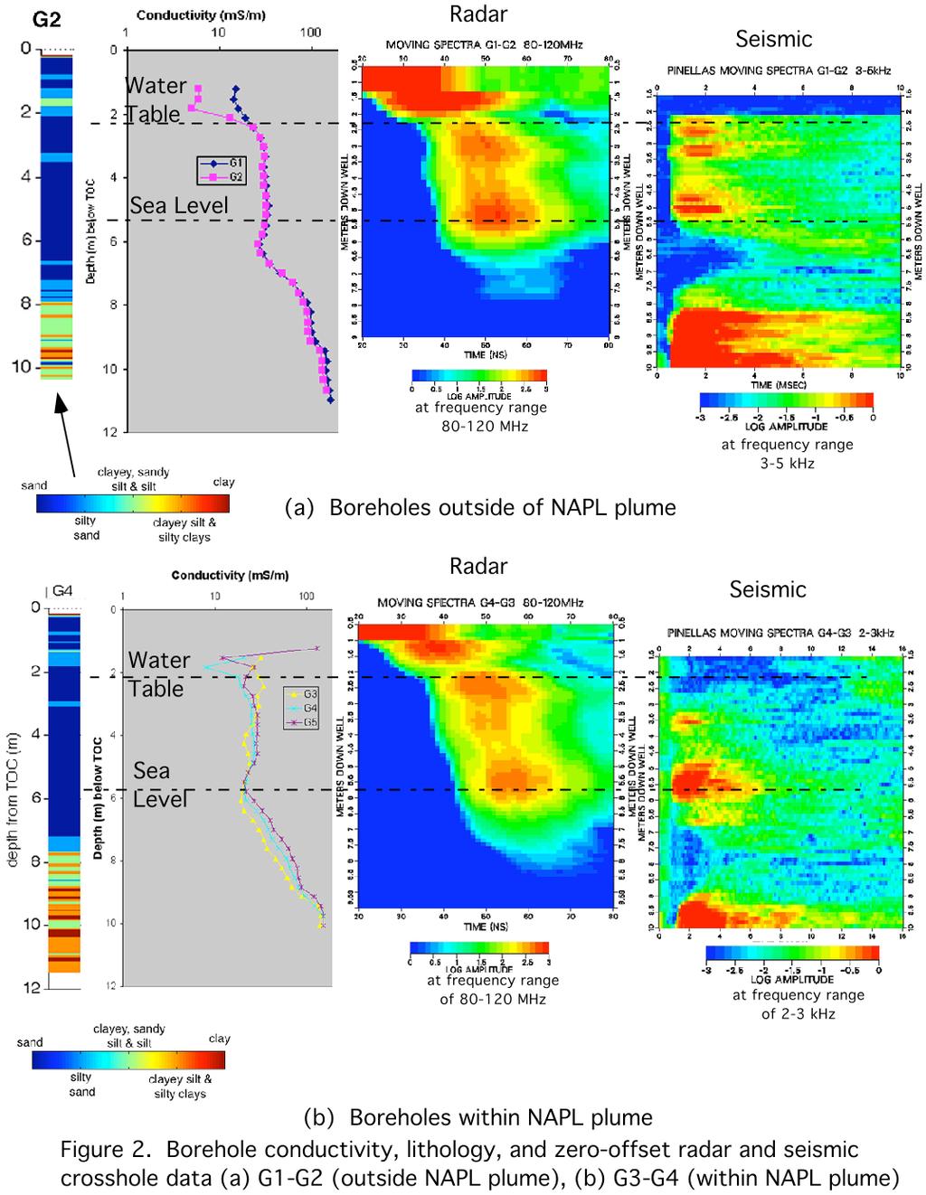
1 1 First Field Test of NAPL Detection with High Resolution Borehole Seismic Imaging Jil T. Geller, John E. Peterson, Kenneth H. Williams, Jonathan B. Ajo!Franklin*, and Ernest L. Majer Earth Sciences Division, Lawrence Berkeley National Laboratory 1 Cyclotron Road Berkeley, CA JTgeller@lbl.gov *Department of Geophysics, Stanford University Abstract The purpose of this field test is to evaluate the detectability of NAPLs by high resolution tomographic borehole seismic imaging. The site is a former Department of Energy (DOE) manufacturing facility in Pinellas County, Florida. Cross!hole seismic and radar measurements were made in a shallow aquifer contaminated with non!aqueous phase liquids (NAPLs). Cone penetration test (CPT) and induction logging were performed for lithology and conductivity, respectively. The main challenge is to distinguish fluid phase heterogeneities from anomalies arising from geologic structure. Our approach is to compare measurements between locations of known contamination with a nearby uncontaminated location of similar lithology where differences in signal transmission may be attributed to fluid phase changes. The CPT data show similar lithologic structure at the locations both within and outside the NAPL!contaminated area.. Zones of low seismic amplitude at about 7 m depth appear more extensive in the NAPL!contaminated area. These zones may be the result of fluid phase heterogeneities (NAPL or gas), or they may be due to the lithology, i.e. attenuating nature of the layer itself, or the transition between two distinct layers. The presence of lithologic contrasts, specifically from higher pemeability sands to lower permeability silts and clays, also indicate potential locations of NAPL, as they could be flow barriers to downward NAPL migration. 1. INTRODUCTION Over the last 15 years LBNL s Earth Sciences Division has developed a high resolution tomographic borehole seismic system to image small!scale structural features which are not detected by exploration seismic methods. The travel time and amplitude attributes are a function of the physical properties of the medium through which the wave travels. Relationships between the attributes and properties of interest can be applied for the desired characterization. This paper presents a new application currently under development! to detect and characterize non! aqueous phase liquid (NAPL) contamination in sedimentary aquifers. Successful high! resolution characterization would define the irregular distribution of NAPL source zone, thus significantly reducing the final cost of remediation by accurately targeting source areas for treatment. The method could also be applied to monitoring remediation and determining efficacy of treatment. Laboratory tests have demonstrated the sensitivity of P!wave transmission to the presence of NAPL contaminants in sand at the centimeter and half!meter scale. (1, 2) In unconsolidated media, the contrast in the acoustic velocity between water and NAPLs results in slower velocities and smaller amplitudes as NAPL saturation increases.
2 2 We are currently testing this technique at the field!scale. The main challenge is to distinguish fluid phase heterogeneities from anomalies arising from geologic structure. Our approach is to compare measurements between locations of known contamination with a nearby uncontaminated location. Other characterization data, such as crosswell radar, borehole conductivity and cone penetration testing (CPT) support interpretation. NAPLs typically have low dielectric permittivity and electrical conductivity relative to water, and consequently radar velocities and amplitudes are expected to increase as NAPL saturation increases. Radar signals also respond to lithology changes. Velocities decrease with increasing porosity of water!saturated media. Radar attenuation increases with increasing electrical conductivity, caused by clays and/or high ionic strength water. 2. WORK DESCRIPTION Measurements were made at the Northeast Site of the Pinellas Science, Technology, and Research (STAR) Center, in Largo, Pinellas County, Florida. From 1956 to 1994, the STAR Center, currently owned by Pinellas County, was a Department of Energy (DOE) facility for manufacturing neutron generators and other electronic and mechanical components for nuclear weapons. The Northeast Site was used for storage of waste solvent and resin drums, and construction debris. The surficial aquifer at the site is a heterogeneous distribution of beach!type deposits, including fine sands with variable shell content, and silty and clayey sands. The water table depth is about 2 m below ground surface and the aquifer is approximately 9 m deep. The Hawthorn Group, an 18 to 21 m thick confining layer, underlies the surficial aquifer. Below the Hawthorn Group is the Floridian Aquifer, a limestone formation, which is an important regional groundwater resource. The map in Figure 1 shows one part of the site identified to have NAPL contamination, as determined by soil sampling and analyses performed by DOE and their contractors. (3,4) NAPL has also been directly observed in the wells shown in blue and sampled in the red wells. The NAPL contaminants include trichloroethylene (TCE), toluene, methylene chloride (MeCl 2) and oil. TCE has been detected near the top of the Hawthorn Group; no contamination has reached the Floridian Aquifer.

3 3 Figure 1 also shows the locations of survey boreholes within the NAPL area (G3!G4) and at a nearby location in a zone identified as "uncertain" (G1!G2). The boreholes are 2" ID, PVC!cased, 10 m deep and were installed with a CPT rig. Seismic surveys were performed with a 1.5" piezoelectric source transducer and a 24! element hydrophone string receiver. The radar surveys were performed with a PulseEKKO100 borehole ground penetrating radar system (Sensors and Software, Inc.), with both 100 MHz and 200 MHz borehole antennas. Conductivity logs were taken with a Geonics, Corp. EM!39 electrical conductivity logger. CPT logs of sleeve and tip friction, and water pressure, were obtained in G2 and G4, before the casing was installed, and used to derive lithology. Measurements in boreholes in other locations of the site are described elsewhere. (5)
4 4 3. RESULTS P!wave velocities for various fluids and solids are shown in Table I. NAPLs and air have significant velocity contrasts with water. The reflection coefficient of different NAPL!water pairs varies; lab measurements to!date suggest that scattering of transmitted waves will be more significant for the NAPL!water pairs that have higher reflection coefficients. Table I. Contrast in P!wave transmission through water and NAPL contaminants Fluids acoustic velocity (km/s) density (kg/m3) acoustic impedance (kg/m 2!s) bulk modulus (MPa) reflection coefficient (1) from water to NAPL Air ( E E!01 water 1.47 (2) E !! toluene (3) E E!01 methylene chloride (CH 2Cl 2) (3) E E!02 TCE 1.05 (3) E !2.02E!02 (1) a negative number indicates the polarization of the wave changes (2) ref: (3) measured in our lab by pulse!transmission with 0.5 MHz contact transducers in a custom!built triaxial test cell References for other data are available upon request. The field data is summarized in Figure 2. The lithology of G2 is similar to G4, with the upper 7 m consisting of sands with some silty! sand layers, which appear at almost the same depths at each location. This zone is referred to as the upper surficial aquifer. The lower surficial aquifer begins at around 6 m depth. Borehole electrical conductivity logs show an increasing trend in conductivity at this depth (near sea level). The G1 and G2 conductivity logs are almost identical, while values vary between G3 and G4. The crosshole seismic and radar data are displayed as vertical distribution of amplitudes along the time axis of the received wave, called moving spectra. These amplitudes are bounded within a given frequency range and are computed from the zero!offset waveforms (i.e. transmitter and receiver at the same depth.) There is no discretization in the horizontal direction. The radar plot shows the water table at about 2.25 m, where arrival times sharply increase. Amplitudes are high through the sands, and decrease from the point where borehole electrical conductivity values increase, and finally disappear. Arrival times through the sands in the G3!G4 pair increase with depth due to the deviation of the borehole from vertical, attributed to the bowing of the CPT rod during installation. Radar velocities ranged from to m/ns. In the seismic moving spectra for G1!G2, the upper half of the plot shows four discreet high amplitude layers. Just below the middle of the plot (at 6.5 m), there is a layer of almost no energy transmission, and very low velocity (much greater arrival times). This low energy layer occurs just above the silty!sands noted in the lithology and coincides with the beginning of increasing electrical conductivities and the top of the lower surficial aquifer. Below this is a high amplitude layer that corresponds to clayey, sandy silts. Seismic velocities at the site range from 1600 to 1800 m/s, which is typical for clays and sands. For 3 khz frequency, this gives wavelengths on the order of 60 cm.
5 5 The seismic moving spectra plot for G3!G4 shows alternating high and low amplitude zones as in G1!G2, but the zone of low amplitude extends over a greater depth in G3!G4. Another zone of reduced energy transmission occurs at 4 m depth from TOC, which corresponds to a local minimum in conductivity in G3.
6 6
7 7 4. DISCUSSION AND CONCLUSIONS The first field test provided important information regarding the seismic and radar transmission properties of the Northeast site and general geological structure. Tomographic imaging with this dataset was not derived due to low signal levels and uncertainty in hole deviation. Current work addresses these issues and data has been obtained to derive tomographic images (in progress.) The borehole and zero!offset data do indicate potential NAPL locations. The CPT data show similar lithologic structure at the locations both within and outside the area of detected NAPL contamination. The low amplitude seismic zones may be due fluid phase heterogeneities, to the attenuating nature of the layer itself, or the transition between two distinct layers. The lithology changes in the low amplitude zones, however the onset of increasing electrical conductivities with depth occurs above lithological transitions detected by the CPT. The presence of lithologic contrasts, specifically from higher pemeability sands to lower permeability silts and clays, also indicate potential locations of NAPL, as they could be flow barriers to downward NAPL migration. Current efforts to discriminate between the possible causes of the low seismic amplitude zones.include interpretation of the new tomographic data sets, laboratory testing of core from the site and diagnostic modeling. 5. ACKNOWLEDGMENTS This work was supported by the Office of Environmental Management, Office of Science and Technology, Subsurface Contaminant Focus Area of the U.S. Department of Energy (DOE) under Contract No. DE!AC03!76SF0098. We gratefully acknowledge David S. Ingle, Pinellas Site Manager, U.S. DOE, and his staff from MACTEC!ERS for providing site access and support. 6. REFERENCES 1. GELLER, J. T. and L. R. MYER, "Ultrasonic imaging of organic liquid contaminants in unconsolidated porous media," Journal of Contaminant Hydrology, 19, 3, 85, (1995) 2. GELLER, J. T., M. B. KOWALSKY, P. K. SEIFERT and K. T. NIHEI, "Acoustic Detection of Immiscible Liquids in Sand," Geophysical Research Letters, 27, 3, 417, (2000) 3. U.S.D.O.E., Northeast Site NAPL Characterization Report, Document Number N , Grand Junction, CO, October, (2000a) 4. U.S.D.O.E., Northeast Site NAPL Characterization Report Addendum, Document Number N , Grand Junction, CO, October, (2000b) 5. GELLER, J. T., E.L. MAJER, J. E. PETERSON, K.H. WILLIAMS and S. FLEXSER, Mapping DNAPL Transport and Contamination in Sedimentary and Fractured Rock Aquifers with High Resolution Borehole Seismic Imaging, Project No. SF11SS13 FY01 Annual Report, Report LBNL! 49385, Earth Sciences Division, Lawrence Berkeley National Laboratory, Berkeley, CA, December (2001)
Joint inversion of geophysical and hydrological data for improved subsurface characterization
 Joint inversion of geophysical and hydrological data for improved subsurface characterization Michael B. Kowalsky, Jinsong Chen and Susan S. Hubbard, Lawrence Berkeley National Lab., Berkeley, California,
Site characterization at the Groundwater Remediation Field Laboratory
 Site characterization at the Groundwater Remediation Field Laboratory WILLIAM P. C LEMENT, STEVE CARDIMONA, ANTHONY L. ENDRES, Boston College, Boston, Massachusetts KATHARINE KADINSKY-CADE, Phillips Laboratory,
Geophysical Site Investigation (Seismic methods) Amit Prashant Indian Institute of Technology Gandhinagar
 Amit Prashant Indian Institute of Technology Gandhinagar") Geophysical Site Investigation (Seismic methods) Amit Prashant Indian Institute of Technology Gandhinagar Short Course on Geotechnical Aspects of Earthquake Engineering 04 08 March, 2013 Seismic Waves
Geophysical Site Investigation (Seismic methods) Amit Prashant Indian Institute of Technology Gandhinagar Short Course on Geotechnical Aspects of Earthquake Engineering 04 08 March, 2013 Seismic Waves
Borehole Seismic Monitoring of Injected CO 2 at the Frio Site
 Borehole Seismic Monitoring of Injected CO 2 at the Frio Site * Daley, T M (tmdaley@lbl.gov), Lawrence Berkeley National Lab., 1 Cyclotron Rd, Berkeley, CA 94720 Myer, L (lrmyer@lbl.gov), Lawrence Berkeley
Site Characterization & Hydrogeophysics
 Site Characterization & Hydrogeophysics (Source: Matthew Becker, California State University) Site Characterization Definition: quantitative description of the hydraulic, geologic, and chemical properties
DNAPL migration through interbedded clay-sand sequences
 Groundwater Quality: Natural and Enhanced Restoration of Groundwater Pollution (Proceedings ofthe Groundwater Quality 2001 Conference held al Sheffield. UK. June 2001). IAHS Publ. no. 275. 2002. 455 DNAPL
Geophysics for Environmental and Geotechnical Applications
 Geophysics for Environmental and Geotechnical Applications Dr. Katherine Grote University of Wisconsin Eau Claire Why Use Geophysics? Improve the quality of site characterization (higher resolution and
IMAGING OF DEEP SINKHOLES USING THE MULTI-ELECTRODE RESISTIVITY IMPLANT TECHNIQUE (MERIT) CASE STUDIES IN FLORIDA
 CASE STUDIES IN FLORIDA") IMAGING OF DEEP SINKHOLES USING THE MULTI-ELECTRODE RESISTIVITY IMPLANT TECHNIQUE (MERIT) CASE STUDIES IN FLORIDA David Harro The G3 Group, 2509 Success Drive, Suite 1, Odessa, FL 33556, david.harro@geo3group.com
IMAGING OF DEEP SINKHOLES USING THE MULTI-ELECTRODE RESISTIVITY IMPLANT TECHNIQUE (MERIT) CASE STUDIES IN FLORIDA David Harro The G3 Group, 2509 Success Drive, Suite 1, Odessa, FL 33556, david.harro@geo3group.com
Case Study: University of Connecticut (UConn) Landfill
 Landfill") Case Study: University of Connecticut (UConn) Landfill Problem Statement:» Locate disposal trenches» Identify geologic features and distinguish them from leachate and locate preferential pathways in fractured
Case Study: University of Connecticut (UConn) Landfill Problem Statement:» Locate disposal trenches» Identify geologic features and distinguish them from leachate and locate preferential pathways in fractured
M E M O R A N D U M. Mr. Jonathan K. Thrasher, P.E. and Mr. Ian Kinnear, P.E. PSI
 M E M O R A N D U M TO: FROM: Mr. Mark Schilling Gulf Interstate Engineering Mr. Jonathan K. Thrasher, P.E. and Mr. Ian Kinnear, P.E. PSI DATE: November 11, 2014 RE: Summary of Findings Geotechnical Study
FINAL REPORT GEOPHYSICAL INVESTIGATION WATER TOWER NO. 6 SITE PLANT CITY, FL
 APPENDIX B FINAL REPORT GEOPHYSICAL INVESTIGATION WATER TOWER NO. 6 SITE PLANT CITY, FL Prepared for Madrid Engineering Group, Inc. Bartow, FL Prepared by GeoView, Inc. St. Petersburg, FL February 28,
Improved Hydrogeophysical Parameter Estimation from Empirical Mode Decomposition Processed Ground Penetrating Radar Data
 University of South Carolina Scholar Commons Faculty Publications Earth and Ocean Sciences, Department of 12-1-2009 Improved Hydrogeophysical Parameter Estimation from Empirical Mode Decomposition Processed
RESEARCH PROPOSAL. Effects of scales and extracting methods on quantifying quality factor Q. Yi Shen
 RESEARCH PROPOSAL Effects of scales and extracting methods on quantifying quality factor Q Yi Shen 2:30 P.M., Wednesday, November 28th, 2012 Shen 2 Ph.D. Proposal ABSTRACT The attenuation values obtained
Application of Ground Penetrating Radar for hydro-geological study
 Journal of Scientific & Industrial Research Vol. 65, February 2006, pp. 160-164 Application of Ground Penetrating Radar for hydro-geological study K K K Singh* Central Mining Research Institute, Dhanbad
Imaging of CO 2 Injection during an Enhanced-Oil-Recovery Experiment
 Imaging of CO 2 Injection during an Enhanced-Oil-Recovery Experiment Roland Gritto 1, Thomas M. Daley 1, and Larry R. Myer 1 1 Lawrence Berkeley National Laboratory One Cyclotron Road, MS 90-1116 Berkeley
11/22/2010. Groundwater in Unconsolidated Deposits. Alluvial (fluvial) deposits. - consist of gravel, sand, silt and clay
 deposits. - consist of gravel, sand, silt and clay") Groundwater in Unconsolidated Deposits Alluvial (fluvial) deposits - consist of gravel, sand, silt and clay - laid down by physical processes in rivers and flood plains - major sources for water supplies
Groundwater in Unconsolidated Deposits Alluvial (fluvial) deposits - consist of gravel, sand, silt and clay - laid down by physical processes in rivers and flood plains - major sources for water supplies
Geophysical Applications GPR Ground Penetrating Radar
 Overview: Basics of GPR Radar-wave velocity, attenuation and skin depth Modes of acquisition The Radar-range equation Dielectric properties of materials and relation to porosity Case studies [Archeology,
Crosswell tomography imaging of the permeability structure within a sandstone oil field.
 Crosswell tomography imaging of the permeability structure within a sandstone oil field. Tokuo Yamamoto (1), and Junichi Sakakibara (2) (1) University of Miami and Yamamoto Engineering Corporation, (2)
CO 2 Rock Physics: A Laboratory Study
 CO 2 Rock Physics: A Laboratory Study Helen Yam* University of Alberta, Edmonton, Alberta, Canada hyam@ualberta.ca and Douglas R. Schmitt University of Alberta, Edmonton, Alberta, Canada Summary It is
Station Description Sheet GRA
 Station Description Sheet GRA 1. General Information 2. Geographical Information / Geomorphology 3. Geological Information 4. Geotechnical Site Characterization 5. Geophysical Site Characterization 6.
GEOTECHNICAL SITE CHARACTERIZATION
 GEOTECHNICAL SITE CHARACTERIZATION Neil Anderson, Ph.D. Professor of Geology and Geophysics Richard W. Stephenson, P.E., Ph.D. Professor of Civil, Architectural and Environmental Engineering University
ATTENUATION CHARACTERISTICS OF SAUDI ARABIAN RESERVOIR SANDSTONE AND LIMESTONE CORES
 ATTENUATION CHARACTERISTICS OF SAUDI ARABIAN RESERVOIR SANDSTONE AND LIMESTONE CORES M. A. Mohiuddin 1, G. Korvin 2, A. Abdulraheem 1, and K. Khan 1 1 Center for Petroleum & Minerals, The Research Institute.
GEOLOGICAL FRACTURE MAPPING USING ELECTROMAGNETIC GEOTOMOGRAPHY. A.L. Ramirez, F.J. Deadrick and R.J. Lytle
 GEOLOGICAL FRACTURE MAPPING USING ELECTROMAGNETIC GEOTOMOGRAPHY A.L. Ramirez, F.J. Deadrick and R.J. Lytle Lawrence Livermore National Laboratory Livermore, California 94550 ABSTRACT This article describes
LECTURE 10. Module 3 : Field Tests in Rock 3.6 GEOPHYSICAL INVESTIGATION
 LECTURE 10 3.6 GEOPHYSICAL INVESTIGATION In geophysical methods of site investigation, the application of the principles of physics are used to the study of the ground. The soil/rock have different characteristics
CROSSHOLE RADAR TOMOGRAPHY IN AN ALLUVIAL AQUIFER NEAR BOISE, IDAHO. Abstract. Introduction
 CROSSHOLE RADAR TOMOGRAPHY IN AN ALLUVIAL AQUIFER NEAR BOISE, IDAHO William P. Clement, Center for Geophysical Investigation of the Shallow Subsurface, Boise State University, Boise, ID, 83725 Warren Barrash,
Groundwater. (x 1000 km 3 /y) Reservoirs. Oceans Cover >70% of Surface. Groundwater and the. Hydrologic Cycle
 Reservoirs. Oceans Cover >70% of Surface. Groundwater and the. Hydrologic Cycle") Chapter 13 Oceans Cover >70% of Surface Groundwater and the Hydrologic Cycle Oceans are only 0.025% of Mass Groundwater Groundwater is liquid water that lies in the subsurface in fractures in rocks and
Chapter 13 Oceans Cover >70% of Surface Groundwater and the Hydrologic Cycle Oceans are only 0.025% of Mass Groundwater Groundwater is liquid water that lies in the subsurface in fractures in rocks and
A25 Very High Resolution Hard Rock Seismic Imaging for Excavation Damage Zone Characterisation
 A25 Very High Resolution Hard Rock Seismic Imaging for Excavation Damage Zone Characterisation C. Cosma* (Vibrometric Oy), N. Enescu (Vibrometric Oy) & E. Heikkinen (Pöyry Finland Oy) SUMMARY Seismic and
RADIONUCLIDE DIFFUSION IN GEOLOGICAL MEDIA
 GEOPHYSICS RADIONUCLIDE DIFFUSION IN GEOLOGICAL MEDIA C. BUCUR 1, M. OLTEANU 1, M. PAVELESCU 2 1 Institute for Nuclear Research, Pitesti, Romania, crina.bucur@scn.ro 2 Academy of Scientists Bucharest,
Sabal Trail Pipeline Project Evaluation of Karst Topography and Sinkhole Potential for Pipeline and Facilities
 November 11, 2014 Sabal Trail Pipeline Project Evaluation of Karst Topography and Sinkhole Potential for Pipeline and Facilities Gulf Interstate Engineering Attention: Mr. Denys Stavnychyi - Project Engineer
The UK GeoEnergy Test Bed Ceri J Vincent British Geological Survey
 The UK GeoEnergy Test Bed Ceri J Vincent British Geological Survey Thanks to Matthew Hall (GTB Theme Lead for G ERA), Phil Meldrum, Russell Swift, Oliver Kuras, Richard Luckett, Andrew Butcher, Jonathan
SEISMIC WAVE PROPAGATION ACROSS IN-FILLED FRACTURES
 Proceedings of the Project Review, Geo-Mathematical Imaging Group (Purdue University, West Lafayette IN), Vol. 1 (2009) pp. 193-204. SEISMIC WAVE PROPAGATION ACROSS IN-FILLED FRACTURES ANGEL A. ACOSTA-COLON,
Ground subsidence is a worldwide problem especially
 Ground Engineering: GPR A Case Study on Ground Subsidence Using Ground Penetrating Radar Nur Azwin Ismail and Rosli Saad Geophysics Section, School of Physics, Universiti Sains Malaysia Ground subsidence
Sabal Trail Pipeline Project Evaluation of Karst Topography and Sinkhole Potential for Pipeline and Facilities
 November 11, 2014 Sabal Trail Pipeline Project Evaluation of Karst Topography and Sinkhole Potential for Pipeline and Facilities Gulf Interstate Engineering Attention: Mr. Denys Stavnychyi - Project Engineer
P- and S-Wave Velocity Measurements and Pressure Sensitivity Analysis of AVA Response
 P- and S-Wave Velocity Measurements and Pressure Sensitivity Analysis of AVA Response Tiewei He* University of Alberta, Edmonton, Alberta, Canada tieweihe@phys.ualberta.ca and Douglas Schmitt University
Hydrogeophysics - Seismics
 Hydrogeophysics - Seismics Matthias Zillmer EOST-ULP p. 1 Table of contents SH polarized shear waves: Seismic source Case study: porosity of an aquifer Seismic velocities for porous media: The Frenkel-Biot-Gassmann
ambiguity in earth sciences IESO Geophysics Section Eddy hartantyo, Lab Geofisika FMIPA UGM
 ambiguity in earth sciences IESO Geophysics Section Eddy hartantyo, Lab Geofisika FMIPA UGM Pelatihan Tahap II IESO Teknik Geologi UGM Februari 2009 1 Introduction Photos from http://www.eegs.org/whatis/
Applied Geophysics for Environmental Site Characterization and Remediation
 Applied Geophysics for Environmental Site Characterization and Remediation MSECA Webinar September 24, 2015 John Mundell, P.E., L.P.G. Ryan Brumbaugh, L.P.G. MUNDELL & ASSOCIATES, INC. Webinar Objective
KANSAS GEOLOGICAL SURVEY Open File Report LAND SUBSIDENCE KIOWA COUNTY, KANSAS. May 2, 2007
 KANSAS GEOLOGICAL SURVEY Open File Report 2007-22 LAND SUBSIDENCE KIOWA COUNTY, KANSAS Prepared by Michael T. Dealy L.G., Manager, Wichita Operations SITE LOCATION The site was approximately four miles
ERTH2020 Introduction to Geophysics The Seismic Method. 1. Basic Concepts in Seismology. 1.1 Seismic Wave Types
 ERTH2020 Introduction to Geophysics The Seismic Method 1. Basic Concepts in Seismology 1.1 Seismic Wave Types Existence of different wave types The existence of different seismic wave types can be understood
GPR surveys at Nõmmküla Detection of underground water routes
 GPR surveys at Nõmmküla 2009 Detection of underground water routes Tomi Herronen & Timo Saarenketo 2009 1. Introduction The purpose of this survey was to locate possible underground water routes (rivers)
Aquitard Characterization The Legend of Indiana s Magic Clay Layer. Juliet Port, LPG #2214 July 2014
 Aquitard Characterization The Legend of Indiana s Magic Clay Layer Juliet Port, LPG #2214 July 2014 Topics What is an Aquitard? Why do we care? Review of Indiana glacial geology Conceptual Framework Investigation
Use of Seismic and EM Data for Exploration, Appraisal and Reservoir Characterization
 Use of Seismic and EM Data for Exploration, Appraisal and Reservoir Characterization Anton Ziolkowski and Folke Engelmark Petroleum Geo-Services CSEG, Calgary, 6 May 2009 Outline Exploration, appraisal,
Hydrogeology of Karst NE Wisconsin. Dr. Maureen A. Muldoon UW-Oshkosh Geology Department
 Hydrogeology of Karst NE Wisconsin Dr. Maureen A. Muldoon UW-Oshkosh Geology Department WI Bedrock Outline Karst Landscapes Existing WQ Data Flow in Karst Aquifers Overview of Silurian Aquifer Water Level
David de Courcy-Bower and Samuel Mohr
 Applicability and Limitations of LNAPL Transmissivity as a Metric within Bedrock Formations Insert then choose Picture select your picture. Right click your picture and Send to back. David de Courcy-Bower
Well Logging Importance in Oil and Gas Exploration and Production
 Well Logging Importance in Oil and Gas Exploration and Production Dr. R. Giri Prasad 1 1 Associate Professor, Dept. of Petroleum Engineering, Aditya Engineering College, hod_pt@aec.edu.in I. INTRODUCTION
Chapter 12 Subsurface Exploration
 Page 12 1 Chapter 12 Subsurface Exploration 1. The process of identifying the layers of deposits that underlie a proposed structure and their physical characteristics is generally referred to as (a) subsurface
Techniques for determining the structure and properties of permafrost
 Stanford Exploration Project, Report 80, May 15, 2001, pages 1 404 Techniques for determining the structure and properties of permafrost Ray Abma 1 ABSTRACT Several methods for predicting the relationship
Lawrence Berkeley National Laboratory
 Lawrence Berkeley National Laboratory Peer Reviewed Title: Fracture permeability and seismic wave scattering--poroelastic linear-slip interface model for heterogeneous fractures Author: Nakagawa, S. Publication
Groundwater. (x 1000 km 3 /y) Oceans Cover >70% of Surface. Groundwater and the. Hydrologic Cycle
 Oceans Cover >70% of Surface. Groundwater and the. Hydrologic Cycle") Chapter 17 Oceans Cover >70% of Surface Groundwater and the Hydrologic Cycle Vasey s Paradise, GCNP Oceans are only 0.025% of Mass Groundwater Groundwater is liquid water that lies in the subsurface in
Chapter 17 Oceans Cover >70% of Surface Groundwater and the Hydrologic Cycle Vasey s Paradise, GCNP Oceans are only 0.025% of Mass Groundwater Groundwater is liquid water that lies in the subsurface in
Pressure Grouting of Fractured Bedrock to Control Acid Mine Drainage
 WATER RESOURCES AT RISK May 14-18, 1995 Denver American Institute of Hydrology Pressure Grouting of Fractured Bedrock to Control Acid Mine Drainage S. A. Effner, G. D. Vandersluis, and V. Straskraba Hydro-Geo
INTRODUCTION TO LOGGING TOOLS
 BY: MUHAMMAD ZAHID INTRODUCTION TO LOGGING TOOLS 1- SPONTANEOUS POTENTIAL (SP) The Spontaneous potential survey, (sp) was one of the first measurements, which was carried out, in a well bore. The SP log
Borehole radar measurements aid structure geological interpretations
 Ž. Journal of Applied Geophysics 43 2000 www.elsevier.nlrlocaterjappgeo Borehole radar measurements aid structure geological interpretations S. Wanstedt ), S. Carlsten, S. Tiren GEOSIGMA, Box 894, S-751
EVALUATION OF STRENGTH OF SOILS AGAINST LIQUEFACTION USING PIEZO DRIVE CONE
 4 th International Conference on Earthquake Geotechnical Engineering June 25-28, 2007 Paper No. 1146 EVALUATION OF STRENGTH OF SOILS AGAINST LIQUEFACTION USING PIEZO DRIVE CONE Shun-ichi Sawada 1 ABSTRACT
Cone Penetration Testing in Geotechnical Practice
 Cone Penetration Testing in Geotechnical Practice Table Of Contents: LIST OF CONTENTS v (4) PREFACE ix (2) ACKNOWLEDGEMENTS xi (1) SYMBOL LIST xii (4) CONVERSION FACTORS xvi (6) GLOSSARY xxii 1. INTRODUCTION
Integration of seismic and fluid-flow data: a two-way road linked by rock physics
 Integration of seismic and fluid-flow data: a two-way road linked by rock physics Abstract Yunyue (Elita) Li, Yi Shen, and Peter K. Kang Geologic model building of the subsurface is a complicated and lengthy
Assessing the Tier 2 Trigger for Fractured Sedimentary Bedrock Sites
 Assessing the Tier 2 Trigger for Fractured Sedimentary Bedrock Sites Ken Lyon, Jennifer Arnold, Louise Burden Advisian WorleyParsons Group RemTech 2015, October 16, Banff, AB INTRODUCTION High level look
Ground Penetration Radar Survey at Yallah s Lower Basin, St. Thomas May , and June
 Ground Penetration Radar Survey at Yallah s Lower Basin, St. Thomas May 28-29., and June 01.-03. 2004 Faisal Butt and Nils-Otto Kitterød University of the West Indies, Mona Campus, Kingston, June 2004
SASKATCHEWAN STRATIGRAPHY GLACIAL EXAMPLE BOULDERS IN GLACIAL DEPOSITS
 SASKATCHEWAN STRATIGRAPHY GLACIAL EXAMPLE BOULDERS IN GLACIAL DEPOSITS 51 SASKATCHEWAN STRATIGRAPHY GLACIAL SURFICIAL STRATIFIED DEPOSITS 52 SASKATCHEWAN STRATIGRAPHY GLACIAL EXAMPLE OF SEDIMENT DEPOSITION
NAPLES MUNICIPAL AIRPORT
 NAPLES MUNICIPAL AIRPORT NAPLES MUNICIPAL AIRPORT (APF) TAXIWAY D REALIGNMENT AND DRAINAGE IMPROVEMENTS NORTH QUADRANT ADDENDUM NUMBER TWO March, The following Addendum is hereby made a part of the Plans
This document downloaded from vulcanhammer.net vulcanhammer.info Chet Aero Marine
 This document downloaded from vulcanhammer.net vulcanhammer.info Chet Aero Marine Don t forget to visit our companion site http://www.vulcanhammer.org Use subject to the terms and conditions of the respective
11301 Reservoir Analogues Characterization by Means of GPR
 11301 Reservoir Analogues Characterization by Means of GPR E. Forte* (University of Trieste) & M. Pipan (University of Trieste) SUMMARY The study of hydrocarbon reservoir analogues is increasing important
SEISMIC RADAR AND ELECTRICAL TECHNIQUES FOR WASTE DISPOSAL ASSESSMENT. M. Pipan, G. Dal Moro, E. Forte & M. Sugan
 SEISMIC RADAR AND ELECTRICAL TECHNIQUES FOR WASTE DISPOSAL ASSESSMENT M. Pipan, G. Dal Moro, E. Forte & M. Sugan Department of Geological, Environmental and Marine Sciences, University of Trieste Via Weiss,
GPR AS A COST EFFECTIVE BEDROCK MAPPING TOOL FOR LARGE AREAS. Abstract
 GPR AS A COST EFFECTIVE BEDROCK MAPPING TOOL FOR LARGE AREAS Dr. Jutta L. Hager, Hager GeoScience, Inc., Waltham, MA Mario Carnevale, Hager GeoScience, Inc., Waltham, MA Abstract Hager GeoScience, Inc.
POTASH DRAGON CHILE GEOPHYSICAL SURVEY TRANSIENT ELECTROMAGNETIC (TEM) METHOD. LLAMARA and SOLIDA PROJECTS SALAR DE LLAMARA, IQUIQUE, REGION I, CHILE
 METHOD. LLAMARA and SOLIDA PROJECTS SALAR DE LLAMARA, IQUIQUE, REGION I, CHILE") POTASH DRAGON CHILE GEOPHYSICAL SURVEY TRANSIENT ELECTROMAGNETIC (TEM) METHOD LLAMARA and SOLIDA PROJECTS SALAR DE LLAMARA, IQUIQUE, REGION I, CHILE OCTOBER 2012 CONTENT Page I INTRODUCTION 1 II FIELD
POTASH DRAGON CHILE GEOPHYSICAL SURVEY TRANSIENT ELECTROMAGNETIC (TEM) METHOD LLAMARA and SOLIDA PROJECTS SALAR DE LLAMARA, IQUIQUE, REGION I, CHILE OCTOBER 2012 CONTENT Page I INTRODUCTION 1 II FIELD
Minnesota Department of Transportation Geotechnical Section Cone Penetration Test Index Sheet 1.0 (CPT 1.0)
") This Cone Penetration Test (CPT) Sounding follows ASTM D 5778 and was made by ordinary and conventional methods and with care deemed adequate for the Department's design purposes. Since this sounding was
This Cone Penetration Test (CPT) Sounding follows ASTM D 5778 and was made by ordinary and conventional methods and with care deemed adequate for the Department's design purposes. Since this sounding was
NOTICE CONCERNING COPYRIGHT RESTRICTIONS
 NOTICE CONCERNING COPYRIGHT RESTRICTIONS This document may contain copyrighted materials. These materials have been made available for use in research, teaching, and private study, but may not be used
Chapter 13. Groundwater
 Chapter 13 Groundwater Introduction Groundwater is all subsurface water that completely fills the pores and other open spaces in rocks, sediments, and soil. Groundwater is responsible for forming beautiful
Oak Ridge IFRC. Quantification of Plume-Scale Flow Architecture and Recharge Processes
 Oak Ridge IFRC Quantification of Plume-Scale Flow Architecture and Recharge Processes S. Hubbard *1, G.S. Baker *2, D. Watson *3, D. Gaines *3, J. Chen *1, M. Kowalsky *1, E. Gasperikova *1, B. Spalding
Mechanical Wave Measurements. Electromagnetic Wave Techniques. Geophysical Methods GEOPHYSICAL SITE CHARACTERIZATION. Mechanical Wave Geophysics
 Geophysical Methods GEOPHYSICAL SITE CHARACTERIZATION Mechanical Wave Measurements Electromagnetic Wave Techniques Mechanical Wave Measurements Crosshole Tests (CHT) Downhole Tests (DHT) Spectral Analysis
Florida s Karst Geology
 Florida s Karst Geology Orange Creek Basin Interagency Working Group Public Workshop, November 5 th, 2015 Harley Means, P.G. Assistant State Geologist Florida Geological Survey Karst Karst a type of topography
A Case Study on Ground Subsidence Using Ground Penetrating Radar
 2012 International Conference on Environmental, Biomedical and Biotechnology IPCBEE vol.41 (2012) (2012) IACSIT Press, Singapore A Case Study on Ground Using Ground Penetrating Radar Nur Azwin Ismail +
Shale Development and Hydraulic Fracturing or Frac ing (Fracking) What is it?
 What is it?") P E T R O L E U M E N G I N E E R I N G D E P A R T M E N T Shale Development and Hydraulic Fracturing or Frac ing (Fracking) What is it? Dr. Will Fleckenstein, PE Colorado School of Mines 1 Who is involved
P E T R O L E U M E N G I N E E R I N G D E P A R T M E N T Shale Development and Hydraulic Fracturing or Frac ing (Fracking) What is it? Dr. Will Fleckenstein, PE Colorado School of Mines 1 Who is involved
GLE 594: An introduction to applied geophysics
 GL 594: An introduction to applied geophysics Ground Penetrating Radar Fall 005 Ground Penetrating Radar Reading Today: 309-316 Next class: 316-39 Introduction to GPR Using the reflection (and sometimes
Finding Large Capacity Groundwater Supplies for Irrigation
 Finding Large Capacity Groundwater Supplies for Irrigation December 14, 2012 Presented by: Michael L. Chapman, Jr., PG Irrigation Well Site Evaluation Background Investigation Identify Hydrogeologic Conditions
Groundwater Hydrology
 EXERCISE 12 Groundwater Hydrology INTRODUCTION Groundwater is an important component of the hydrologic cycle. It feeds lakes, rivers, wetlands, and reservoirs; it supplies water for domestic, municipal,
Minnesota Department of Transportation Geotechnical Section Cone Penetration Test Index Sheet 1.0 (CPT 1.0)
") This Cone Penetration Test (CPT) Sounding follows ASTM D 778 and was made by ordinary and conventional methods and with care deemed adequate for the Department's design purposes. Since this sounding was
This Cone Penetration Test (CPT) Sounding follows ASTM D 778 and was made by ordinary and conventional methods and with care deemed adequate for the Department's design purposes. Since this sounding was
Modeling seismic wave propagation during fluid injection in a fractured network: Effects of pore fluid pressure on time-lapse seismic signatures
 Modeling seismic wave propagation during fluid injection in a fractured network: Effects of pore fluid pressure on time-lapse seismic signatures ENRU LIU, SERAFEIM VLASTOS, and XIANG-YANG LI, Edinburgh
BOS 100 Overburden and Bedrock Groundwater Remediation Former Dry Cleaning Facility
 BOS 100 Overburden and Bedrock Groundwater Remediation Former Dry Cleaning Facility Site Description Location Central Kentucky Site Use Retail Shopping Center Geologic Setting Inner Bluegrass Bedrock Ordovician
SCOPE OF INVESTIGATION Simple visual examination of soil at the surface or from shallow test pits. Detailed study of soil and groundwater to a
 Lecture-5 Soil Exploration Dr. Attaullah Shah 1 Today s Lecture Purpose of Soil Exploration Different methods 1. Test trenches and Pits 2. Auger and Wash Boring 3. Rotary Drilling 4. Geophysical Methods
Surface Processes Focus on Mass Wasting (Chapter 10)
") Surface Processes Focus on Mass Wasting (Chapter 10) 1. What is the distinction between weathering, mass wasting, and erosion? 2. What is the controlling force in mass wasting? What force provides resistance?
Surface Processes Focus on Mass Wasting (Chapter 10) 1. What is the distinction between weathering, mass wasting, and erosion? 2. What is the controlling force in mass wasting? What force provides resistance?
Appendix D Fractured Rock Appendix
 Appendix D Fractured Rock Appendix 1.0 Introduction The behavior of LNAPL in fractured bedrock is not necessarily intuitive and is not as easily described using the principles and techniques adopted for
Soils, Hydrogeology, and Aquifer Properties. Philip B. Bedient 2006 Rice University
 Soils, Hydrogeology, and Aquifer Properties Philip B. Bedient 2006 Rice University Charbeneau, 2000. Basin Hydrologic Cycle Global Water Supply Distribution 3% of earth s water is fresh - 97% oceans 1%
LINK BETWEEN ATTENUATION AND VELOCITY DISPERSION
 LINK BETWEEN ATTENUATION AND VELOCITY DISPERSION Jack Dvorkin Stanford University and Rock Solid Images April 25, 2005 SUMMARY In a viscoelastic sample, the causality principle links the attenuation of
Coupled seismoelectric wave propagation in porous media. Mehran Gharibi Robert R. Stewart Laurence R. Bentley
 Coupled seismoelectric wave propagation in porous media Mehran Gharibi Robert R. Stewart Laurence R. Bentley a Introduction Seismic waves induce electric and magnetic fields. Conversion of acoustic energy
Patterns in Geophysical Data and Models
 Patterns in Geophysical Data and Models Jens Tronicke Angewandte Geophysik Institut für Geowissenschaften Universität Potsdam jens@geo.uni-potsdam.de Near-surface geophysics Using geophysical tools to
INNOVATIVE TECHNIQUES TO INVESTIGATE CONTAMINATION IN FRACTURED BEDROCK
 INNOVATIVE TECHNIQUES TO INVESTIGATE CONTAMINATION IN FRACTURED BEDROCK Abstract Christopher Gaule 1, Kenneth Goldstein 2, Grant Anderson 3 Watervliet Arsenal, located in Watervliet, New York, is the oldest
Static Corrections for Seismic Reflection Surveys
 Static Corrections for Seismic Reflection Surveys MIKE COX Volume Editors: Series Editor: Eugene F. Scherrer Roland Chen Eugene F. Scherrer Society of Exploration Geophysicists Tulsa, Oklahoma Contents
The process of determining the layers of natural soil deposits that will underlie a proposed structure and their physical properties is generally
 The process of determining the layers of natural soil deposits that will underlie a proposed structure and their physical properties is generally referred to as sub surface investigation 2 1 For proper
EOSC252 - Exercise 9
 Name: 1. Introduction EOSC252 - Exercise 9 Dielectric properties This is really nothing more than a multiple choice / short answer quiz-style assignment. You will need to have done the readings about dielectric
Measurement, Monitoring and Verification (MMV)
") Measurement, Monitoring and Verification (MMV) Larry Myer USCSC CCS Capacity Building Workshop Charleston, West Virginia October 25, 2011 Outline Why monitor? Information needs Monitoring methods Baselines
Measurement, Monitoring and Verification (MMV) Larry Myer USCSC CCS Capacity Building Workshop Charleston, West Virginia October 25, 2011 Outline Why monitor? Information needs Monitoring methods Baselines
Prof. Stephen A. Nelson EENS 111. Groundwater
 Page 1 of 8 Prof. Stephen A. Nelson EENS 111 Tulane University Physical Geology This page last updated on 20-Oct-2003 is water that exists in the pore spaces and fractures in rock and sediment beneath
Soil Behaviour Type from the CPT: an update
 Soil Behaviour Type from the CPT: an update P.K. Robertson Gregg Drilling & Testing Inc., Signal Hill, California, USA ABSTRACT: One of the most common applications of CPT results is to evaluate soil type
BPM37 Linking Basin Modeling with Seismic Attributes through Rock Physics
 BPM37 Linking Basin Modeling with Seismic Attributes through Rock Physics W. AlKawai* (Stanford University), T. Mukerji (Stanford University) & S. Graham (Stanford University) SUMMARY In this study, we
Station Description Sheet STE
 Station Description Sheet STE 1. General Information 2. Geographical Information / Geomorphology 3. Geological Information 4. Geotechnical Site Characterization. Geophysical Site Characterization 6. Site
Use of Non-Invasive Near-Surface Geophysics for Managing Brine Releases
 Use of Non-Invasive Near-Surface Geophysics for Managing Brine Releases Presented by: Brent W. Barker, Staff Geophysicist Remediation Technologies Symposium 2012 Imagine the result Co-Authors Boyce L.
Velocity Measurements of Pore Fluids at Pressure and Temperature: Application to bitumen
 Velocity Measurements of Pore Fluids at Pressure and Temperature: Application to bitumen Arif Rabbani 1*, Douglas R Schmitt 1, Jason Nycz 2, and Ken Gray 3 1 Institute for Geophysical Research, Department
SUMMARY INTRODUCTION EXPERIMENTAL PROCEDURE
 Frequency dependent elastic properties and attenuation in heavy-oil sands: comparison between measured and modeled data Agnibha Das, and Michael Batzle, Colorado School of Mines SUMMARY We have measured
ENVIRONMENTAL EFFECTS OF GROUNDWATER WITHDRAWAL IN SOUTH NYÍRSÉG
 PhD thesis ENVIRONMENTAL EFFECTS OF GROUNDWATER WITHDRAWAL IN SOUTH NYÍRSÉG János Szanyi Szeged, 2004 ENVIRONMENTAL EFFECTS OF GROUNDWATER WITHDRAWAL IN SOUTH NYÍRSÉG Preliminaries, the aims of the dissertation
Borehole Acoustics and Logging Consortium. Annual Report
 Borehole Acoustics and Logging Consortium Annual Report 1994 EARTH RESOURCES LABORATORY Department of Earth, Atmospheric, and Planetary Sciences Massachusetts Institute of Technology Cambridge, Mass. 02139
RESISTIVITY IMAGING AND BOREHOLE INVESTIGATION OF THE BANTING AREA AQUIFER, SELANGOR, MALAYSIA. A.N. Ibrahim Z.Z.T. Harith M.N.M.
 JOURNAL OF ENVIRONMENTAL HYDROLOGY The Electronic Journal of the International Association for Environmental Hydrology On the World Wide Web at http://www.hydroweb.com VOLUME 11 2003 RESISTIVITY IMAGING