Underground Risk Management Course Marina Del Rey, California November, Geotechnical Data Reports. Greg Raines, PE
|
|
|
- Bennett Curtis
- 5 years ago
- Views:
Transcription

1 Underground Risk Management Course Marina Del Rey, California November, 2018 Geotechnical Data Reports Greg Raines, PE
2 Introduction What is a Geotechnical Data Report? The GDR is a document developed by the Designer and/or the Designer's geotechnical engineer, which contains the factual information that has been gathered during the exploration and design phases of the Project. The GDR should contain the following information: a description of the geologic setting; a description/discussion of the site exploration program; the logs of all borings, trenches, and other site investigations; a description/discussion of all field and laboratory test programs; and the results of all field and laboratory testing. The GDR should NOT interpret ANY geological or geotechnical data.

3 Geologic Profile LEGEND

4 Geologic Profile LEGEND


5 Introduction Geotechnical Reports Geotechnical Reports Contract Document Non-Contract Document GDR Data Only GBR Interpretive Baseline GDM Interpretive Geotech
6 Introduction Disclaimers Disclaimers have been used in the past by Owners to broadly disclaim all subsurface information made available to bidders. This practice is in direct conflict with the concept of geotechnical reports. A Contractor has a right to rely on data provided. Any broad, exculpatory language intended to shed responsibility from the Owner would be ignored by the courts. A narrowly worded disclaimer can be used in the GDR to: eliminate unreliable data from further consideration; shed responsibility for the accuracy of subsurface information obtained by third parties for unrelated projects; differentiate conservative design assumptions from best estimate interpretations of subsurface conditions and behavior.
7 Introduction Geotechnical Data Report 1. Project Overview 2. Area Geology a) Geologic Map b) Seismic setting and regional faults c) Definition of relevant geologic terms 3. Field Investigation a) Boring logs and rock core photos b) Logging procedures c) Drilling procedures d) Groundwater evaluation e) Field testing 4. Laboratory Testing a) Testing standards b) Testing strategy c) Types and number of tests d) Results summary
8 Introduction Geotechnical Data Report Appendices 1. Geological Reconnaissance and Mapping 2. Boring Log data 3. Field Testing Data 4. Geophysics 5. Groundwater data 6. Laboratory data 7. Historical Data
9 Geological Reconnaissance and Mapping Appendix - Geological Reconnaissance and Mapping Collect available data Field geologic mapping Structural data collection Kinematic analysis

10 Geological Reconnaissance and Mapping Identify/Collect Available Geotechnical Data in the Project Area Information can include: Geologic maps Data from previous reports Drill hole data Preliminary mapping Compile available local data into a database for further evaluation.

11 Geological Reconnaissance and Mapping Field Geologic Mapping

 Mapping at the scale of the")
12 Geological Reconnaissance and Mapping Field Geologic Mapping Structural Data Collection (faults, folds, shears, contacts, alteration zones) Mapping at the scale of the project/features!


13 Geological Reconnaissance and Mapping Geologic Mapping and Reconnaissance


14 Geological Reconnaissance and Mapping Geomechanical Mapping of Discontinuities (Kinematic Data Analysis)
15 Boring Log Data Appendix Boring Log Data Drilling methods Boring log legend, boring logs, and completion logs Sampling methods and equipment (SPTs) Hand held field tests (torvane) Groundwater level measurements Sample handling, CoC
 Rock Core Each of these methods have pros and cons and are well suited for specific exploration programs, depending on both the subsurface conditions as well as the data")
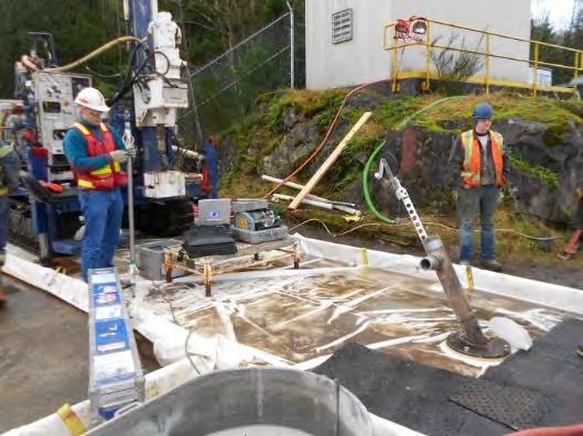
16 Boring Log Data Types of Rigs Some typical methods to drill the subsurface include: Auger Mud/Air Rotary Mud/Air Rotary with Casing Advance Reverse Circulation Sonic Becker Penetration Large Diameter Cone Penetration Tests (CPT) Rock Core Each of these methods have pros and cons and are well suited for specific exploration programs, depending on both the subsurface conditions as well as the data needs for the program.


17 Boring Log Data Types of Rigs Auger Pros: Simple, widely available No water, mud, or air Accommodates most sampling types Cons: Depth limitations Gravels, cobbles limitations Flowing/running ground limitations Hole collapse (solid stem)


18 Boring Log Data Types of Rigs Mud / Air Rotary Pros: Widely available Accommodates most sampling types Efficient in most ground conditions Cons: Location of G.W. in drill hole Mud impact to sensing/testing zone Cobble/boulder limitations
 Large diameter (nested wells) High depth capacity Cons: Logging cuttings Sampling limitations Larger equipment/support")
19 Boring Log Data Types of Rigs Reverse Circulation Schramm (dual tube RC air percussion rig) Pros: Efficient Can identify water zones (air) Large diameter (nested wells) High depth capacity Cons: Logging cuttings Sampling limitations Larger equipment/support requirements


20 Boring Log Data Types of Rigs Sonic Pros: Efficient No water, mud or air Accommodates most sampling types Nearly full sample recovery Can detect water in recovered core Advance through most geotechnical conditions Cons: Not widely available for investigation purposes Potential for sample disturbance Comparatively slightly higher $/m


21 Boring Log Data Types of Rigs Large Diameter Borings Physical examination/mapping of the intact geologic conditions

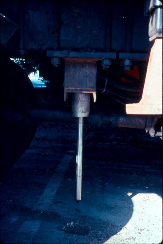
22 Boring Log Data Cone Penetrometer Testing


23 Boring Log Data Types of Rigs Rock Core


24 Boring Log Data Test Pits Used for soil logging, sample collection and lab testing materials anticipated to be encountered.

 Roundness Rocks: Rock")

25 Boring Log Data Typical Drill Hole Logs General: Drill rate Rig Behavior Circulation return Depth to water Instrumentation Drill difficulties Shift changes Testing intervals and results Soil: Lithology Soil type (USCS) Color Consistency / density Grain size distribution Moisture Cementation Plasticity (clays) Roundness Rocks: Rock Type Recovery, RQD, GSI Color Texture Degree of weathering Strength Hardness Structure Discontinuities: Type Width Infilling Amount & Type Surface Shape Roughness Spacing (Joint Sets)


26 Boring Log Data Typical Drill Hole Logs Rock Log Soil Log

27 Boring Log Data Data Compilation Summary Sheets

28 Boring Log Data Core Photos
29 Field Testing Data Appendix Field Testing Data Pressure meter/dilatometer Hydraulic conductivity testing Hydraulic jacking/fracturing Hazardous gas sampling


30 Field Testing Data In Situ Testing Pressure Meter / Dilatometer


 for parameters")
31 Field Testing Data In Situ Testing Hydraulic Conductivity Testing Packer Testing (single and double) Constant Head Falling Head Tunnel Alignment Relates to permeability and groutability of a formation (rock or soil) for parameters used in analysis, and design.
32 Field Testing Data Packer Tests Inflation Tube Inflatable Packer End Cap Test Zone Perforated Screen End Plug
33 Field Testing Data Packer Tests 0.0E E E E E-03 1 K(cm/s)

34 Field Testing Data Packer Testing Results
35 Field Testing Data Hydraulic Jacking and Fracturing Tests Jacking Fracturing Pressurization of borehole is done until fracturing of rock in borehole wall. The rock will generally fracture in the direction perpendicular to the minimum stress direction σ3. The fracture alignment is viewed using borehole televiewer or impression packer. The intermediate and vertical stresses are then calculated from the estimated minimum stress value
 Carbon Dioxide (CO2) Gasoline Vapors Chlorinated Solvents (PCE, DCE, &")
36 Field Testing Data Hazardous Gases & Contaminants Underground Methane (CH4) Hydrogen Sulfide (H2S) Carbon Dioxide (CO2) Gasoline Vapors Chlorinated Solvents (PCE, DCE, & TCE)


37 Field Testing Data Sample Screening Pore gas sampling Groundwater sampling
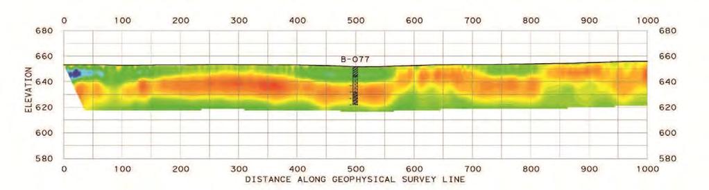
38 Geophysics Appendix Geophysics Down hole geophysics Seismic reflection* Seismic refraction Resistivity Suspension logging Ground penetrating radar Seismic tomography* Bathymetry Magnetics*

39 Geophysics Geophysics Downhole Methods

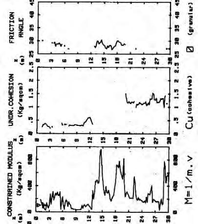
40 Geophysics Downhole Summary Plots
41 Geophysics Suspension Logging
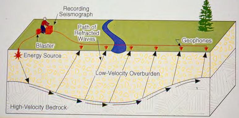
42 Geophysics Seismic Refraction Refraction Compression, P-Wave

43 Geophysics Geophysics - Seismic

44 Geophysics Marine Geophysics

45 Geophysics Seismic Reflection Profile

46 Geophysics Magnetic Survey
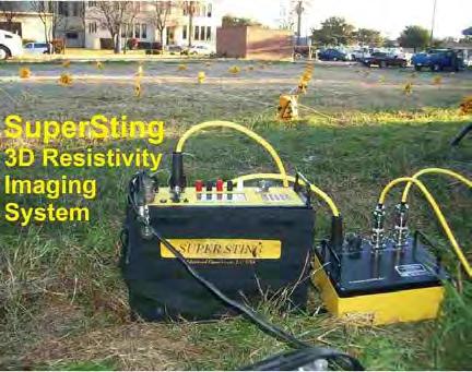
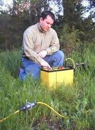
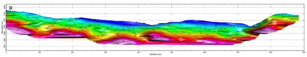
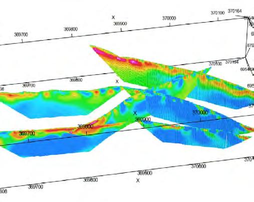
47 Geophysics 3D Resistivity Imaging

48 Geophysics Ground Penetrating Radar (Example: Performed Inside Tunnel)
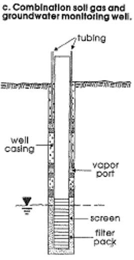
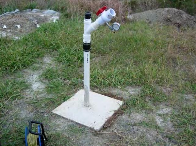
49 Groundwater Data Appendix Groundwater Data Water level monitoring table Well installation completion logs Piezometer data Slug tests and pump testing

50 Groundwater Data Groundwater and Hydrogeologic Conditions


51 Groundwater Data Piezometers Typical stand-pipe piezometer Multi-level Single Multi-level vibrating wire piezometer Fully Grouted Multi-level vibrating wire piezometer
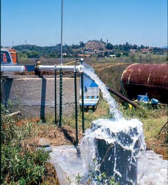
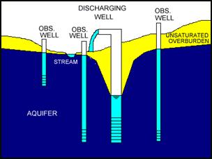
52 Groundwater Data Pump / Slug Tests
53 Groundwater Data Piezometer Completion Diagram
54 Groundwater Data Measuring the Phreatic Surface
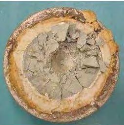
55 Laboratory Testing Data Appendix Laboratory Testing Data Data summary table Individual data sheets, sorted by test type Moisture content and unit weight Specific gravity Seive and hydrometer Atterberg limits Shear strength Consolidation Slake durability and LA Abrasion CERCHAR and Brazilian tensile strength Triaxial testing Corrosion testing


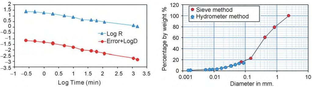
56 Laboratory Testing Data Typical Lab Testing Soil USCS classification Strength & Modulus Moisture/density Plasticity Gradation Hydrometer

57 Laboratory Testing Data Unified Soil Classification System (USCS)


58 Laboratory Testing Data Grain Size Analysis


59 Laboratory Testing Data Plasticity Testing (Atterberg Limits: PI, LL, PL)
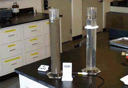
60 Laboratory Testing Data Hydrometer Test


61 Laboratory Testing Data Density & Strength


62 Laboratory Testing Data Different Conditioners Dispersants Foam Injection Ratios High Density Limestone Slurry Bentonite Polymer

63 Laboratory Testing Data Specialized Lab Testing Soil Abrasivity


64 Laboratory Testing Data Typical Lab Testing Rock Rock classification Compressive/shear strength Tensile strength (Brazilian) Moisture/density Durability, abrasivity, slake, toughness
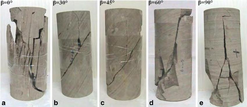
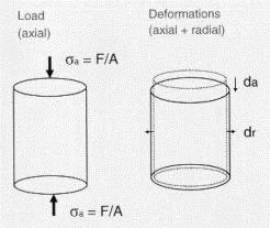
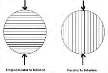
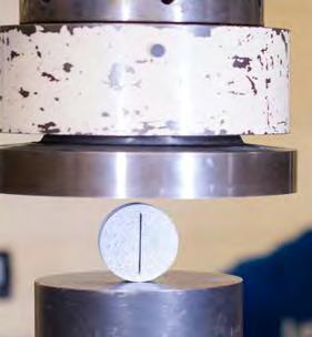
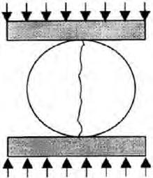
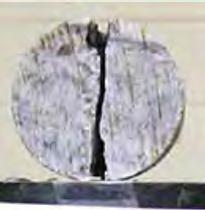
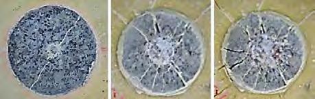
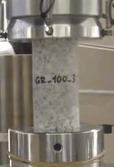
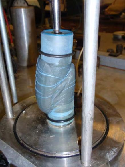
65 Laboratory Testing Data Unconfined Compressive Strength Brazilian Tensile Strength Resiliency (Toughness)

66 Laboratory Testing Data Specialized Lab Testing Punch Penetration and Cerchar Tests

67 Laboratory Testing Data Point Load Index Tests
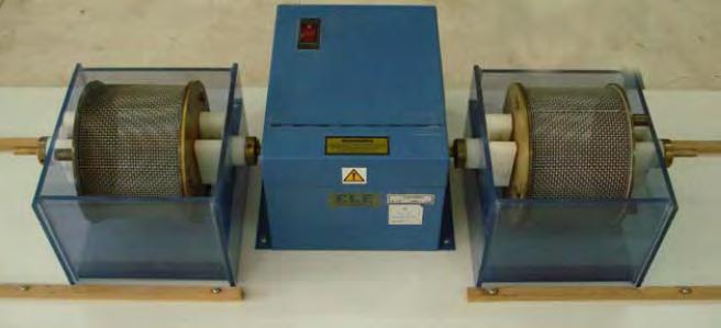
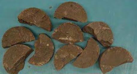
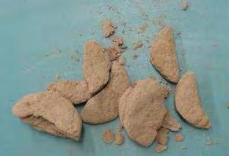
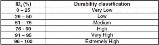
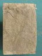
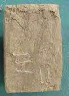
68 Laboratory Testing Data Slake Durability Tests

69 Laboratory Testing Data Thin Section Analysis Granitic Porphyry
70 Conclusion Organization is Key Proper organization is integral to writing a functional and useful geotechnical data report The purpose should be to present the data in a clear manner that allows the designer to find data quickly and easily
71 Conclusion A thorough, robust geotechnical investigation is the best risk mitigation strategy.

72 Conclusion Questions?
Site Investigations and Geotechnical Risk For Underground Construction Greg Raines, PE
 August 14, 2017 Site Investigations and Geotechnical Risk For Underground Construction Greg Raines, PE Gregory.Raines@Stantec.com Develop Preliminary Geologic / Geotech Conceptual Model for the Project
10. GEOTECHNICAL EXPLORATION PROGRAM
 Geotechnical site investigations should be conducted in multiple phases to obtain data for use during the planning and design of the tunnel system. Geotechnical investigations typically are performed in
Manual on Subsurface Investigations National Highway Institute Publication No. FHWA NHI Federal Highway Administration Washington, DC
 Manual on Subsurface Investigations National Highway Institute Publication No. FHWA NHI-01-031 Federal Highway Administration Washington, DC Geotechnical Site Characterization July 2001 by Paul W. Mayne,
Chapter 12 Subsurface Exploration
 Page 12 1 Chapter 12 Subsurface Exploration 1. The process of identifying the layers of deposits that underlie a proposed structure and their physical characteristics is generally referred to as (a) subsurface
KDOT Geotechnical Manual Edition. Table of Contents
 KDOT Geotechnical Manual 2007 Edition The KDOT Geotechnical Manual is available two volumes. Both volumes are very large electronic (pdf) files which may take several minutes to download. The table of
Boreholes. Implementation. Boring. Boreholes may be excavated by one of these methods: 1. Auger Boring 2. Wash Boring 3.
 Implementation Boreholes 1. Auger Boring 2. Wash Boring 3. Rotary Drilling Boring Boreholes may be excavated by one of these methods: 4. Percussion Drilling The right choice of method depends on: Ground
Preliminary Geotechnical and Environmental Report
 ` Preliminary Geotechnical and Environmental Report (Volume 2) December 2011 THIS PAGE INTENTIONALLY LEFT BLANK VOLUME 2 Summary As part of PE phase, the following investigations were performed: Geotechnical
Gotechnical Investigations and Sampling
 Gotechnical Investigations and Sampling Amit Prashant Indian Institute of Technology Gandhinagar Short Course on Geotechnical Investigations for Structural Engineering 12 14 October, 2017 1 Purpose of
Instructional Objectives
 GE 343 SUBSURFACE EXPLORATION CH 8 Rock Drilling, Testing, and Sampling Text Ch. 7. Dr. Norbert H. Maerz Missouri University of Science and Technology (573) 341-6714 norbert@mst.edu Instructional Objectives
Rotary Drilling Rotary Drilling Bits
 GE 343 SUBSURFACE EXPLORATION CH 8 Rock Drilling, Testing, and Sampling Text Ch. 7. Dr. Norbert H. Maerz Missouri University of Science and Technology (573) 341-6714 norbert@mst.edu Instructional Objectives
ENCE 3610 Soil Mechanics. Site Exploration and Characterisation Field Exploration Methods
 ENCE 3610 Soil Mechanics Site Exploration and Characterisation Field Exploration Methods Geotechnical Involvement in Project Phases Planning Design Alternatives Preparation of Detailed Plans Final Design
Instructional Objectives
 GE 6477 DISCONTINUOUS ROCK 8. Fracture Detection Dr. Norbert H. Maerz Missouri University of Science and Technology (573) 341-6714 norbert@mst.edu Instructional Objectives 1. List the advantages and disadvantages
SCOPE OF INVESTIGATION Simple visual examination of soil at the surface or from shallow test pits. Detailed study of soil and groundwater to a
 Lecture-5 Soil Exploration Dr. Attaullah Shah 1 Today s Lecture Purpose of Soil Exploration Different methods 1. Test trenches and Pits 2. Auger and Wash Boring 3. Rotary Drilling 4. Geophysical Methods
SITE INVESTIGATION 1
 SITE INVESTIGATION 1 Definition The process of determining the layers of natural soil deposits that will underlie a proposed structure and their physical properties is generally referred to as site investigation.
The process of determining the layers of natural soil deposits that will underlie a proposed structure and their physical properties is generally
 The process of determining the layers of natural soil deposits that will underlie a proposed structure and their physical properties is generally referred to as sub surface investigation 2 1 For proper
 Project: ITHACA-TOMPKINS REGIONAL AIRPORT EXPANSION Project Location: ITHACA, NY Project Number: 218-34 Key to Soil Symbols and Terms TERMS DESCRIBING CONSISTENCY OR CONDITION COARSE-GRAINED SOILS (major
Appendix J. Geological Investigation
 Appendix J Geological Investigation Appendix J Geological Environment Table of Contents Page 1 INTRODUCTION...J-1 1.1 Purpose of the Investigation...J-1 1.2 Scope of the Investigation...J-1 2 METHODO OF
SI Planning & Laboratory Testing for Hill-Site Development
 SI Planning & Laboratory Testing for Hill-Site Development 21 April 2009 IEM Penang Ir. Tan Yean Chin G&P Geotechnics Sdn Bhd Cameron Highlands, 1961 Genting Highland Tower 1993 Bukit Antarabangsa, 1999
Week 3 : (3HL) Coverage : Typical geotechnical problems and usual application of SI methods
 Coverage : Typical geotechnical problems and usual application of SI methods") LEARNING OUTCOMES Week 3 : (3HL) Coverage : Typical geotechnical problems and usual application of SI methods Learning Outcomes : At the end of this lecture/week, the students will be able to : 1. Discuss
LEARNING OUTCOMES Week 3 : (3HL) Coverage : Typical geotechnical problems and usual application of SI methods Learning Outcomes : At the end of this lecture/week, the students will be able to : 1. Discuss
B-1 BORE LOCATION PLAN. EXHIBIT Drawn By: 115G BROOKS VETERINARY CLINIC CITY BASE LANDING AND GOLIAD ROAD SAN ANTONIO, TEXAS.
 N B-1 SYMBOLS: Exploratory Boring Location Project Mngr: BORE LOCATION PLAN Project No. GK EXHIBIT Drawn By: 115G1063.02 GK Scale: Checked By: 1045 Central Parkway North, Suite 103 San Antonio, Texas 78232
Session - Road Building Fundamentals
 Session - Road Building Fundamentals Topic Foundation Conditions Materials & Performance of Facility Soil/Rock Properties Dave Peterson, P.G., SVP, Principal Geologist November 14, 2013 2013 Arizona Pavements/Materials
TAKING THE MYSTERY OUT OF USACE S ER DRILLING IN EARTH EMBANKMENT DAMS AND LEVEES
 TAKING THE MYSTERY OUT OF USACE S ER 1110-1-1807 DRILLING IN EARTH EMBANKMENT DAMS AND LEVEES 237 237 237 217 217 217 200 200 200 80 119 27 252 174.59 1 255 255 255 0 0 0 163 163 163 131 132 122 239 65
Site investigation in rock
 Site investigation in rock masses Geotechnical Core Drilling & Logging Core Orientation Borehole Surveying Logging g Core Borehole Log Face Mapping Scanline Data Analysis Influence of Joints Orientation
SASKATCHEWAN STRATIGRAPHY GLACIAL EXAMPLE BOULDERS IN GLACIAL DEPOSITS
 SASKATCHEWAN STRATIGRAPHY GLACIAL EXAMPLE BOULDERS IN GLACIAL DEPOSITS 51 SASKATCHEWAN STRATIGRAPHY GLACIAL SURFICIAL STRATIFIED DEPOSITS 52 SASKATCHEWAN STRATIGRAPHY GLACIAL EXAMPLE OF SEDIMENT DEPOSITION
HOW. HOW vehicle mounted units portable units also available. HOW, WHEN & WHY to Geophysically Log in S.I.?
 HOW, WHEN & WHY to Geophysically Log in S.I.? by Kim Beesley HOW HOW vehicle mounted units portable units also available Access to borehole Depth of borehole sump / rat -hole? 1 HOW? - subject to borehole
Horizontal Directional Drilling: An Approach to Design and Construction. Presenter: John Briand, PE Co-Author: Danielle Neamtu, PE
 Horizontal Directional Drilling: An Approach to Design and Construction Presenter: John Briand, PE Co-Author: Danielle Neamtu, PE Presentation Outline General HDD overview Conceptual-level evaluation Detailed
TECHNICAL MEMORANDUM
 TECHNICAL MEMORANDUM Geotechnical Reports Preparation Guidelines TM 2.9.2 Prepared by: Signed document on file Brian O Neill, PE, GE Program Geotechnical Engineer 14 May 09 Checked by: Signed document
Soil Mechanics Brief Review. Presented by: Gary L. Seider, P.E.
 Soil Mechanics Brief Review Presented by: Gary L. Seider, P.E. 1 BASIC ROCK TYPES Igneous Rock (e.g. granite, basalt) Rock formed in place by cooling from magma Generally very stiff/strong and often abrasive
APPENDIX C HYDROGEOLOGIC INVESTIGATION
 Figure B-5.7 Figure B-5.8 Preliminary Geotechnical and Environmental Report Appendix C Hydrogeologic Investigation APPENDIX C HYDROGEOLOGIC INVESTIGATION December 21, 2011 WESTSIDE SUBWAY EXTENSION PROJECT
Amistad Dam Investigation and Oversight: Karst- Founded Dam on the USA-Mexico Border
 Amistad Dam Investigation and Oversight: Karst- Founded Dam on the USA-Mexico Border Brook Brosi, CPG, PG USACE Lisa Nowicki Perks, PG USACE Kimberly Heenan, PE AECOM US Army Corps of Engineers BUILDING
Pressure Grouting of Fractured Bedrock to Control Acid Mine Drainage
 WATER RESOURCES AT RISK May 14-18, 1995 Denver American Institute of Hydrology Pressure Grouting of Fractured Bedrock to Control Acid Mine Drainage S. A. Effner, G. D. Vandersluis, and V. Straskraba Hydro-Geo
Enhanced In-Situ Testing for Geotechnical Site Characterization. Graduate Course CEE 6423
 Enhanced In-Situ Testing for Geotechnical Site Characterization SPT, VST, DMT, PMT, CHT, DHT, CPT Graduate Course CEE 6423 Paul W. Mayne, PhD, P.E. Professor, Geosystems Program Civil & Environmental Engineering
Table of Contents Chapter 1 Introduction to Geotechnical Engineering 1.1 Geotechnical Engineering 1.2 The Unique Nature of Soil and Rock Materials
 Table of Contents Chapter 1 Introduction to Geotechnical Engineering 1.1 Geotechnical Engineering 1.2 The Unique Nature of Soil and Rock Materials 1.3 Scope of This Book 1.4 Historical Development of Geotechnical
IAEA SAFETY STANDARDS Geotechnical Aspects of Site Evaluation and Foundations in NPPs, NS-G-3.6
 IAEA SAFETY STANDARDS Geotechnical Aspects of Site Evaluation and Foundations in NPPs, NS-G-3.6 Regional Workshop on Volcanic, Seismic, and Tsunami Hazard Assessment Related to NPP Siting Activities and
Role of the Geotechnical Consultant in Design Build Projects a General Contractors Geotechnical Engineer s Perspective
 Role of the Geotechnical Consultant in Design Build Projects a General Contractors Geotechnical Engineer s Perspective Steven R. Saye Kiewit Engineering Group, Inc. Design Build Geotechnical Goal All parties
Finding Large Capacity Groundwater Supplies for Irrigation
 Finding Large Capacity Groundwater Supplies for Irrigation December 14, 2012 Presented by: Michael L. Chapman, Jr., PG Irrigation Well Site Evaluation Background Investigation Identify Hydrogeologic Conditions
APPENDIX B SUBSURFACE EXPLORATIONS
 APPENDIX B SUBSURFACE EXPLORATIONS 51-1-10079-028 APPENDIX B SUBSURFACE EXPLORATIONS TABLE OF CONTENTS Page B.1. B.2. B.3. B.4. B.5. B.6. B.7. GENERAL...B-1 HEALTH AND SAFETY PLAN...B-1 DRILLING PROCEDURES...B-1
Module 1 : Site Exploration and Geotechnical Investigation
 Objectives In this section you will learn the following Displacement borings Wash boring Auger boring Rotary drilling Percussion drilling Continuous sampling Boring methods of exploration The boring methods
OVERVIEW OF ER DRILLING IN EARTH EMBANKMENT DAMS AND
 OVERVIEW OF ER 1110-1-1807 DRILLING IN EARTH EMBANKMENT DAMS AND 255 255 255 237 237 237 0 0 0 217 217 217 LEVEES 163 163 163 200 200 200 131 132 122 239 65 53 80 119 27 110 135 120 Requirements and Processes
Depth (ft) USCS Soil Description TOPSOIL & FOREST DUFF
 USCS Soil Description TOPSOIL & FOREST DUFF") Test Pit No. TP-6 Location: Latitude 47.543003, Longitude -121.980441 Approximate Ground Surface Elevation: 1,132 feet Depth (ft) USCS Soil Description 0 1.5 1.5 5.0 SM 5.0 8.0 SM Loose to medium dense,
Test Pit No. TP-6 Location: Latitude 47.543003, Longitude -121.980441 Approximate Ground Surface Elevation: 1,132 feet Depth (ft) USCS Soil Description 0 1.5 1.5 5.0 SM 5.0 8.0 SM Loose to medium dense,
Geotechnical / Geophysical Investigation
 FEATURES TerraDol provides innovative geotechnical and geophysical exploration for civil construction projects including highway, railroad, subway, tunnel, bridge, port, and underground storage projects.
PHYSICO-MECHANICAL PROPERTIES OF ROCKS LECTURE 2. Contents
 PHYSICO-MECHANICAL PROPERTIES OF ROCKS LECTURE 2 Contents 2.1 Introduction 2.2 Rock coring and logging 2.3 Physico-mechanical properties 2.3.1 Physical Properties 2.3.1.1 Density, unit weight and specific
APPENDIX F CORRELATION EQUATIONS. F 1 In-Situ Tests
 APPENDIX F 1 APPENDIX F CORRELATION EQUATIONS F 1 In-Situ Tests 1. SPT (1) Sand (Hatanaka and Uchida, 1996), = effective vertical stress = effective friction angle = atmosphere pressure (Shmertmann, 1975)
Geophysical Site Investigation (Seismic methods) Amit Prashant Indian Institute of Technology Gandhinagar
 Amit Prashant Indian Institute of Technology Gandhinagar") Geophysical Site Investigation (Seismic methods) Amit Prashant Indian Institute of Technology Gandhinagar Short Course on Geotechnical Aspects of Earthquake Engineering 04 08 March, 2013 Seismic Waves
Geophysical Site Investigation (Seismic methods) Amit Prashant Indian Institute of Technology Gandhinagar Short Course on Geotechnical Aspects of Earthquake Engineering 04 08 March, 2013 Seismic Waves
GEOTECHNICAL POLICIES AND PROCEDURES MANUAL CHAPTER 5 GEOTECHNICAL INVESTIGATION PLANNING GUIDELINES
 GEOTECHNICAL POLICIES AND PROCEDURES MANUAL CHAPTER 5 GEOTECHNICAL INVESTIGATION PLANNING GUIDELINES GEOTECHNICAL INVESTIGATION PLANNING GUIDELINES 5-i TABLE OF CONTENTS 1. PURPOSE... 1 2. INTRODUCTION...
This document downloaded from vulcanhammer.net vulcanhammer.info Chet Aero Marine
 This document downloaded from vulcanhammer.net vulcanhammer.info Chet Aero Marine Don t forget to visit our companion site http://www.vulcanhammer.org Use subject to the terms and conditions of the respective
ENGINEERING GEOLOGY AND ROCK ENGINEERING
 1 ENGINEERING GEOLOGY AND ROCK ENGINEERING HANDBOOK NO. 2 Norwegian Group for Rock Mechanics (NBG) www.bergmekanikk.com Prepared in co-operation with Norwegian Tunnelling Society (NFF) Issued in 2000 SECRETARIAT:
The attitude he maintains in his relation to the engineer is very well stated in his own words:
 Su bsurface Soil Exploration, 53: 139 Foundation Engineering Geotechnical companies that have a history of experience in a given region usually have extensive boring logs and maps telling where the borings
AVON DAM MONITORING BOREHOLES REPORT
 AVON DAM MONITORING BOREHOLES REPORT September 2015 Melinda Smart Supervisor Brownfields Exploration Energy and Engineering S2313 AND S2314 MONITORING BOREHOLES Avon Dam Hole 1 (S2313) and Avon Dam Hole
LECTURE 10. Module 3 : Field Tests in Rock 3.6 GEOPHYSICAL INVESTIGATION
 LECTURE 10 3.6 GEOPHYSICAL INVESTIGATION In geophysical methods of site investigation, the application of the principles of physics are used to the study of the ground. The soil/rock have different characteristics
Site Characterization & Hydrogeophysics
 Site Characterization & Hydrogeophysics (Source: Matthew Becker, California State University) Site Characterization Definition: quantitative description of the hydraulic, geologic, and chemical properties
patersongroup Design for Earthquakes Consulting Engineers May 19, 2016 File: PG3733-LET.01
 patersongroup May 19, 2016 File: PG3733-LET.01 Hydro Ottawa Limited c/o Cresa Toronto 170 University Avenue, Suite 1 Toronto, Ontario M5H 3B3 Attention: Ms. Barbara Wright Consulting Engineers 154 Colonnade
Instructional Objectives. Why use mass classification? What is rock mass classification? 3 Pillars of empirical design and rock mass classification
 GE 6477 DISCONTINUOUS ROCK 5. Rock Mass Classification and Empirical Design Dr. Norbert H. Maerz Missouri University of Science and Technology (573) 341-6714 norbert@mst.edu Instructional Objectives 1.
GEOTECHNICAL INVESTIGATION REPORT INFRASTRUCTURE PVT LTD
 GEOTECHNICAL INVESTIGATION REPORT Client : TAEIN CONSTRUCTION & INFRASTRUCTURE PVT LTD Office address : Flat No.104, A -Wing,1st floor,gloria Park, Paranjape Scheme, Bavdhan Khurd, Chandni Chowk, Pune
GEOTECHNICAL ENGINEERING INVESTIGATION HANDBOOK Second Edition
 GEOTECHNICAL ENGINEERING INVESTIGATION HANDBOOK Second Edition Roy E. Hunt Taylor & Francis Taylor & Francis Croup Boca Raton London New York Singapore A CRC title, part of the Taylor & Francis imprint,
APPENDIX A. Borehole Logs Explanation of Terms and Symbols
 APPENDIX A Borehole Logs Explanation of Terms and Symbols Page 153 of 168 EXPLANATION OF TERMS AND SYMBOLS The terms and symbols used on the borehole logs to summarize the results of field investigation
GEOTECHNICAL SITE CHARACTERIZATION
 GEOTECHNICAL SITE CHARACTERIZATION Neil Anderson, Ph.D. Professor of Geology and Geophysics Richard W. Stephenson, P.E., Ph.D. Professor of Civil, Architectural and Environmental Engineering University
7. Foundation and Slope Stability
 The Asian Nuclear Safety Network 7. Foundation and Slope Stability (SER 2.5.4 & 2.5.5) Taek-Mo SHIM k147stm@kins.re.kr Korea Institute of Nuclear Safety Structural Systems and Site Evaluation Department
iii CONTENTS vii ACKNOWLEDGMENTS EXECUTIVE SUMMARY INTRODUCTION Study Area Data Sources Preparation of Geologic Maps
 CONTENTS ACKNOWLEDGMENTS EXECUTIVE SUMMARY INTRODUCTION Study Area Data Sources Preparation of Geologic Maps GEOLOGY Bedrock Geology Succession and Distribution Structural Features Description of Bedrock
NHBRA SOIL LABORATORY SECTION INTERIM REVISED TEST RATES FOR THE MATERIALS LABORATORY
 NHBRA SOIL LABORATORY SECTION INTERIM REVISED TEST RATES FOR THE MATERIALS LABORATORY DATE OF REVISION: ) 10th October 2010 S/N TEST DESCRIPTION UNIT RATE REMARKS 1 Sieve Analysis (wet and dry methods
APPENDIX C. Borehole Data
 APPENDIX C Borehole Data MAJOR DIVISIONS SOIL CLASSIFICATION CHART SYMBOLS GRAPH LETTER TYPICAL DESCRIPTIONS ADDITIONAL MATERIAL
CE 240 Soil Mechanics & Foundations Lecture 5.2. Permeability III (Das, Ch. 6) Summary Soil Index Properties (Das, Ch. 2-6)
 Summary Soil Index Properties (Das, Ch. 2-6)") CE 40 Soil Mechanics & Foundations Lecture 5. Permeability III (Das, Ch. 6) Summary Soil Index Properties (Das, Ch. -6) Outline of this Lecture 1. Getting the in situ hydraulic conductivity 1.1 pumping
CE 40 Soil Mechanics & Foundations Lecture 5. Permeability III (Das, Ch. 6) Summary Soil Index Properties (Das, Ch. -6) Outline of this Lecture 1. Getting the in situ hydraulic conductivity 1.1 pumping
ontribution of Geotechnical and Rock echanics design to vertical shaft nking and design
 ontribution of Geotechnical and Rock echanics design to vertical shaft nking and design CONTENTS Geological and Geotechnical investigations Pre-sink Examples of Pre-sinking in soft soils Ancillary excavations
SITE CHARACTERIZATION
 SITE CHARACTERIZATION Part 2. Intrusive Investigation Technologies Tyler E. Gass, CPG Tetra Tech, Inc. Louisville, CO SITE CHARACTERIZATION INTRUSIVE TECHNOLOGIES Defining the Objectives of the Investigation
Geotechnical project work flow
 Wulf Schubert INTRODUCTION The approach to solve an engineering problem is to combine experience with analysis The more complex the conditions are, the more difficult a direct analysis becomes, as appropriate
CONTENTS. 1. GeneralsG Field Investigation WorkG Laboratory Testing Work Surface Soil Description-- 7.
 CONTENTS Page 1. GeneralsG 4 2. Field Investigation WorkG 4 3. Laboratory Testing Work--- 5 4. Surface Soil Description-- 7 Appendix A Borehole Location Plan 11 Soil Profile-- 15 Bore Logs--=---- 18 Appendix
Applied Geophysics for Environmental Site Characterization and Remediation
 Applied Geophysics for Environmental Site Characterization and Remediation MSECA Webinar September 24, 2015 John Mundell, P.E., L.P.G. Ryan Brumbaugh, L.P.G. MUNDELL & ASSOCIATES, INC. Webinar Objective
A. V T = 1 B. Ms = 1 C. Vs = 1 D. Vv = 1
 Geology and Soil Mechanics 55401 /1A (2002-2003) Mark the best answer on the multiple choice answer sheet. 1. Soil mechanics is the application of hydraulics, geology and mechanics to problems relating
Geology and Soil Mechanics /1A ( ) Mark the best answer on the multiple choice answer sheet.
 Mark the best answer on the multiple choice answer sheet.") Geology and Soil Mechanics 55401 /1A (2003-2004) Mark the best answer on the multiple choice answer sheet. 1. Soil mechanics is the application of hydraulics, geology and mechanics to problems relating
Geology and Soil Mechanics 55401 /1A (2003-2004) Mark the best answer on the multiple choice answer sheet. 1. Soil mechanics is the application of hydraulics, geology and mechanics to problems relating
An Introduction to Field Explorations for Foundations
 An Introduction to Field Explorations for Foundations J. Paul Guyer, P.E., R.A. Paul Guyer is a registered mechanical engineer, civil engineer, fire protection engineer and architect with over 35 years
Guidelines for Site-Specific Seismic Hazard Reports for Essential and Hazardous Facilities and Major and Special-Occupancy Structures in Oregon
 Guidelines for Site-Specific Seismic Hazard Reports for Essential and Hazardous Facilities and Major and Special-Occupancy Structures in Oregon By the Oregon Board of Geologist Examiners and the Oregon
2 OVERVIEW OF SHALLOW BOREHOLE INVESTIGATIONS
 2 OVERVIEW OF SHALLOW BOREHOLE INVESTIGATIONS Preparation for MSB-2 started in April 2002. Drilling and planned field work in both MSB-2 and 4 were carried out at the same time. After completion of the
IN SITU TESTING TECHNOLOGY FOR FOUNDATION & EARTHQUAKE ENGINEERING. Wesley Spang, Ph.D., P.E. AGRA Earth & Environmental, Inc.
 IN SITU TESTING TECHNOLOGY FOR FOUNDATION & EARTHQUAKE ENGINEERING Wesley Spang, Ph.D., P.E. AGRA Earth & Environmental, Inc. Portland, Oregon In situ testing of soil, which essentially consists of evaluating
Chapter 3 SUBSOIL EXPLORATION. Omitted parts: Sections & 3.24, 3.25 Examples 3.3, 3.4,3.5
 Chapter 3 SUBSOIL EXPLORATION Omitted parts: Sections 3.2-3.10 & 3.24, 3.25 Examples 3.3, 3.4,3.5 GENERAL OBSERVATION Soil does not posses a unique or linear stress-strain relationship. Soil behavior depends
Project S4: ITALIAN STRONG MOTION DATA BASE. Deliverable # D3. Definition of the standard format to prepare descriptive monographs of ITACA stations
 Agreement INGV-DPC 2007-2009 Project S4: ITALIAN STRONG MOTION DATA BASE Responsibles: Francesca Pacor, INGV Milano Pavia and Roberto Paolucci, Politecnico Milano http://esse4.mi.ingv.it Deliverable #
Predicting Settlement and Stability of Wet Coal Ash Impoundments using Dilatometer Tests
 Predicting Settlement and Stability of Wet Coal Ash Impoundments using Dilatometer Tests Chris Hardin, P.E. CH2M Hill, Charlotte, North Carolina, E-mail: Chris.Hardin@ch2m.com Roger Failmezger, P.E., F.
Geotechnical Models and Data Confidence in Mining Geotechnical Design
 Geotechnical Models and Data Confidence in Mining Geotechnical Design Michael Dunn Principal Consultant (Geotechnical Engineering) Overview Geotechnical models Geotechnical model and design Data reliability
How to Interpret Mining Company Drill Reports & Announcements
 How to Interpret Mining Company Drill Reports & Announcements A Simple Guide amscot Stockbroking Pty Ltd A division of State One Stockbroking Ltd (AFSL 247 100) Disclaimer: All information in this document
 SOIL CLASSIFICATION CHART COARSE-GRAINED SOILS MORE THAN 50% RETAINED ON NO.200 SIEVE FINE-GRAINED SOILS 50% OR MORE PASSES THE NO.200 SIEVE PRIMARY DIVISIONS GRAVELS MORE THAN 50% OF COARSE FRACTION RETAINED
Geotechnical Data Report
 Geotechnical Data Report Downtown Greenville Future Conveyance Study December 1, 2015 Terracon Project No. 86155032 Prepared for: Prepared by: Terracon Consultants, Inc. December 1, 2015 561 Mauldin Road
MICRO TO MACRO ARE UK LINEAR INFRASTRUCTURE GI S SUITABLE FOR INVESTIGATING MASS SOIL PROPERTY CHARACTERISTICS?
 MICRO TO MACRO ARE UK LINEAR INFRASTRUCTURE GI S SUITABLE FOR INVESTIGATING MASS SOIL PROPERTY CHARACTERISTICS? Ben Gilson - Arup 1 OUTLINE 1. Context why linear infrastructure? 2. Geotechnical challenges
Geotechnical Engineering Report
 Geotechnical Engineering Report Turner Turnpike Widening Bridge B Bridge Crossing: South 257 th West Avenue Creek County, Oklahoma June 1, 2016 Terracon Project No. 04155197 Prepared for: Garver, LLC Tulsa,
APPENDIX A GEOTECHNICAL REPORT
 The City of Winnipeg Bid Opportunity No. 529-2017 Template Version: C420170317 - RW APPENDIX A GEOTECHNICAL REPORT Quality Engineering Valued Relationships KGS Group 2017 Industrial Street Rehabilitation
Geotechnical Geotechnical Assessment
 Site Investigation Site Investigation Pile Probing Pile Probing Geotechnical Logging Geotechnical and Sampling Logging and Sampling Streetworks and Utilities Streetworks Avoidance and Utilities Avoidance
Core Barrels. Core Barrels
 Core Barrels To collect the core of the rock drilled, a device known as the core barrel is used. Core barrel retains rock core samples from drilling operations Its length varies from 0.5 to 3 m. There
TBM "Boreability" in Hard Rock
 JMConsulting-Rock Engineering TBM "Boreability" in Hard Rock Javier Macias, PhD Rock Engineering Consultant and Researcher JMConsulting-Rock Engineering AS Anvendt bergmekanikk 10.01.2018, Trondheim Outline
BELFAST SEWERS PROJECT
 BELFAST SEWERS PROJECT Adam Green - Atkins Tunnelling Scheme Overview New stormwater interceptor Tunnel Scheme within Belfast City Centre to alleviate flooding and divert storm water flows from existing
Determining In Situ Properties of Claystone Aquitards Using Pore Pressure Responses from Grouted-in Pressure Transducers
 Determining In Situ Properties of Claystone Aquitards Using Pore Pressure Responses from Grouted-in Pressure Transducers Laura A. Smith, S. Lee Barbour, M. Jim Hendry University of Saskatchewan, Saskatoon,
Rock Mechanics and Seismology Laboratory
 CAEE 211 Geology Laboratory 6 Lab Date: 29 July 2016 Rock Mechanics and Seismology Laboratory Due Date: 5 August 2016 Attendance (based on signing): 30 points Submitting Student Name: Members of laboratory
Underground Excavation Design Classification
 Underground Excavation Design Underground Excavation Design Classification Alfred H. Zettler alfred.zettler@gmx.at Rock Quality Designation Measurement and calculation of RQD Rock Quality Designation index
VOLUME III GEOLOGY, HYDROGEOLOGY & GEOTECHNICAL REPORT CAPITAL REGION RESOURCE RECOVERY CENTRE
 VOLUME III GEOLOGY, HYDROGEOLOGY & GEOTECHNICAL REPT CAPITAL REGION RESOURCE RECOVERY CENTRE APPENDIX A Borehole Records December Report No. //vol III LIST OF ABBREVIATIONS The abbreviations coonly employed
GEOTECHNICAL ENGINEERING II. Subject Code : 06CV64 Internal Assessment Marks : 25 PART A UNIT 1
 GEOTECHNICAL ENGINEERING II Subject Code : 06CV64 Internal Assessment Marks : 25 PART A UNIT 1 1. SUBSURFACE EXPLORATION 1.1 Importance, Exploration Program 1.2 Methods of exploration, Boring, Sounding
3.0 SUMMARY OF FINDINGS
 AECOM 500 W Jefferson St. Suite 1600 Louisville, KY 40202 www.aecom.com 502-569-2301 tel 502-569-2304 fax October 17, 2018 Big Rivers Electric Corporation Sebree Generating Station 9000 Highway 2096 Robards,
GEOTECHNICAL INVESTIGATION OF RAILWAYS
 GEOTECHNICAL INVESTIGATION OF RAILWAYS Prof. Hannes Gräbe University of Pretoria Transnet Chair in Railway Engineering May 2011 Contents Cost considerations Objectives Phased approach to site investigation
Geotechnical Engineering and Dams
 Geotechnical Engineering and Dams Solving Geotechnical Challenges for Hydropower and Water Resources Projects Geological and geotechnical challenges are often very demanding when planning hydraulic structures.
GEOLOGY, SOILS, AND SEISMICITY
 4.9 GEOLOGY, SOILS, AND SEISMICITY 4.9.1 Introduction Information about the geological conditions and seismic hazards in the study area was summarized in the FEIR, and was based on the Geotechnical Exploration
Site Investigation and Landfill Construction I
 Site Investigation and Landfill Construction I Gernot Döberl Vienna University of Technology Institute for Water Quality, Resources and Waste Management Contents Site Investigation Base Liners Base Drainage
Chapter 1 Introduction
 Chapter 1 Introduction 1.1 Statement of the Problem Engineering properties of geomaterials are very important for civil engineers because almost everything we build - tunnels, bridges, dams and others
Geotechnical Testing Methods I
 Geotechnical Testing Methods I Ajanta Sachan Assistant Professor Civil Engineering IIT Gandhinagar Hiding World of Geotechnical Engg!! Foundations Shoring Tunneling Soil Exploration Geotechnical Engg Structures
Cone Penetration Testing in Geotechnical Practice
 Cone Penetration Testing in Geotechnical Practice Table Of Contents: LIST OF CONTENTS v (4) PREFACE ix (2) ACKNOWLEDGEMENTS xi (1) SYMBOL LIST xii (4) CONVERSION FACTORS xvi (6) GLOSSARY xxii 1. INTRODUCTION