Springshed Springshed Management Training Curriculum
|
|
|
- Abel Andrews
- 5 years ago
- Views:
Transcription
1 Springshed Springshed Management Training Curriculum Management Training Curriculum Draft Version 2 January 2016 The Springs Initiative 2016 The Springs Initiative
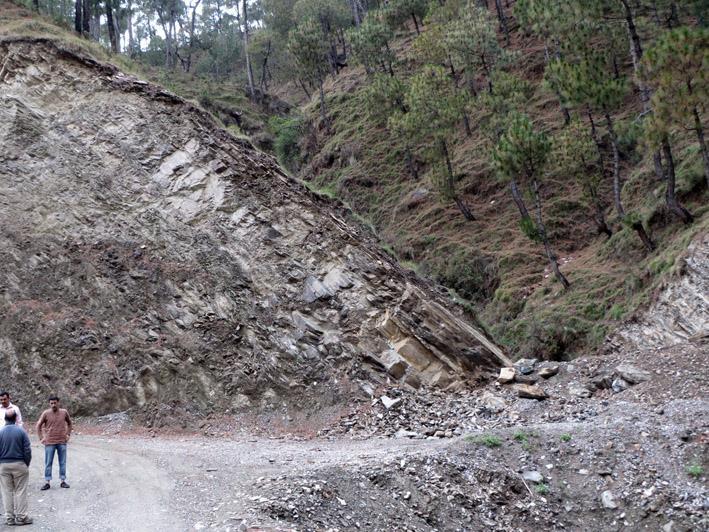
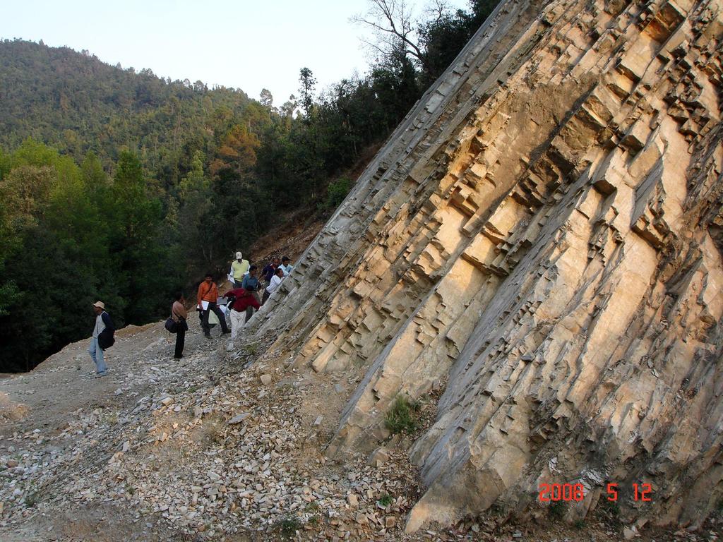
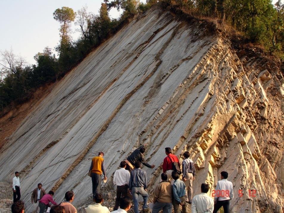
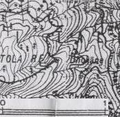
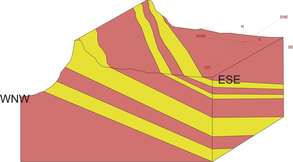
2 SESSION TITLE: Section Mapping SECTION: Understanding the Resource MODULE: III. Springshed Mapping AUTHORS: Dr Himanshu Kulkarni CONTRIBUTING ORGANIZATIONS: ACWADAM PURPOSE: To be able to understand geology through strikes & dips, sections, classifying GPS points on Google maps and contour mapping. IMPACT: Participants will be familiar with plotting geologic sections, adding geology through Google maps and interpreting strikes and dips of the geology to define recharge and discharge areas. TIME REQUIRED: 90 minutes MATERIALS: This ppt, tracing paper, graph paper, scale, protractor, printed maps, box model ADDITIONAL RESOURCES:
3 Outline: How to take strike & dip Using strike and dip in the valley to valley approach Understanding drainage and geology through Google maps To plot a section through contour mapping Use sections to construct 3-D layout and geologic layouts Creating vertical profiles from transects Making 3D layouts & oblique views
4

5 The Watershed Watershed-Model Here is an example spring and springshed from the Himalayas Groundwater Model Spring
6 Springs : a valley to valley approach We explored the area to determine where recharge was occurring Spring outlet
7 Springs : a valley to valley approach Field surveys showed evidence of layers of rock sloping toward the spring outlet Spring outlet
8 Springs : a valley to valley approach We could reasonably assume that recharge was occurring in the valley above the spring where water would infiltrate and migrate down the rock beds to emerge as a spring Spring outlet Spring outlet
9 Springs : a valley to valley approach We could reasonably assume that recharge was occurring in the valley above the spring where water would infiltrate and migrate down the rock beds to emerge as a spring Spring outlet
10 Springs : a valley to valley approach Further surveys found another spring. But this one was near a large and obvious fault. Did the water come from the same place as the first spring? Spring 2 outlet Spring outlet
11 Springs : a valley to valley approach Rocks here was sloping in a different direction than at the first spring Spring 2 outlet Spring outlet
12 Springs : a valley to valley approach So we could assume that the recharge areas were thus: Spring 2 outlet Spring outlet
13 Springs : a valley to valley approach And when the surveys continued along the mountain, yet another recharge area was discovered

14 Springs : a valley to valley approach Must move beyond ridge to valley Recharge areas do not follow surface topography Must map the geology So how do we do that?
15 Trends : Strike and Dip Methods for mapping position and attitude of rocks, formations and structure
16 Trends : Strike and Dip Strike the compass direction of where the feature intersects a horizontal plane Dip the direction and degrees from the horizontal plane

17 Trends : Strike and Dip Strike the compass direction of where the feature intersects a horizontal plane Dip the direction and degrees from the horizontal plane
18 Symbols

19 Strike & Dip Rocks Bedding planes Fractures Joints Faults Foliation Dyke Folds 30 N
20 Perspective Horizontal rocks -rock type -contact elevation Inclined rocks -rock type -dip, strike -elevation Horizontal rocks in the field Inclined rocks in the field


21 Perspective Horizontal rocks -rock type -contact elevation Inclined rocks -rock type -dip, strike -elevation Horizontal rocks in the field Inclined rocks in the field
22
23

24 Strike
25
26
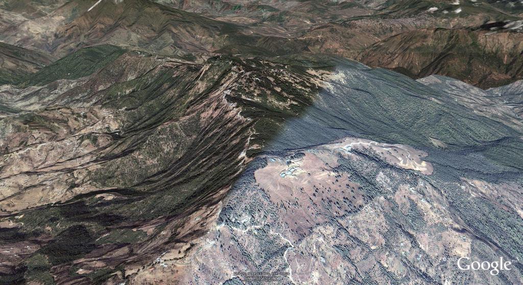
27 Dip
28
29
30
31

32
 -Spring/dhara (S1,2,3,.) -Naula (N1,2,3,..) Geological mapping -traverse along pre identified fracture zones from google image/toposheet -stream channels -road cuttings -along dip direction")
33 Geological mapping -GPS -Hammer -Clinometer -Basemap (Hand drawn /toposheet/google earth image) Google earth Toposheet Drainage Analysis GPS (codes) -Geology (G1,2,3,4, ) -Fractures (F1,2,3,4..) -Spring/dhara (S1,2,3,.) -Naula (N1,2,3,..) Geological mapping -traverse along pre identified fracture zones from google image/toposheet -stream channels -road cuttings -along dip direction

34 Google earth base map
35 Tilt view in google earth The importance of a Conceptual layout over a geological map
36 A google image Drainage
37 GPS points on a google image
38 Classifying GPS points on a google image Quartzite Debris Fracture points Phyllite Spring
39 Creating a geological map Quartzite Debris Fracture points Phyllite Spring
40 Creating a geological map Quartzite Debris Fracture points Phyllite Spring
41 Creating a geological map Quartzite Debris Fracture points Phyllite Spring
42 Creating a geological map Quartzite Debris Fracture points Phyllite Spring
43 Creating a geological map Quartzite Debris Fracture points Phyllite Spring
44 Creating a geological map Quartzite Debris Fracture points Phyllite Spring
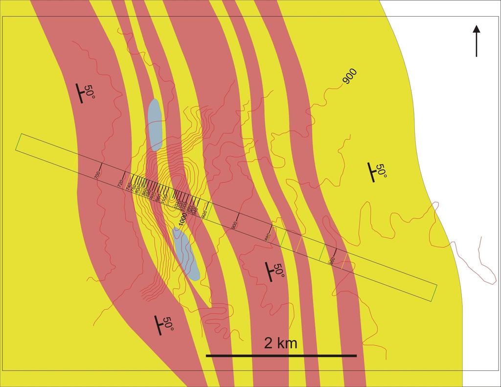
45 Creating a geological map Quartzite Debris Fracture points Phyllite Spring
46 Tilt view in google earth The importance of a Conceptual layout over a geological map
47 Interpolating geology
48 Interpolating geology
49 Interpolating geology
50 Interpolating geology
51 Interpolating geology

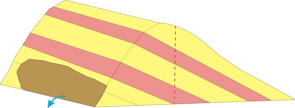
52 A 3-D layout

53 A contour map
54 Contours and geology
55
56 Creating a section from the profile
57 11 10 Creating a section from the profile
58 11 10 Creating a section from the profile
59 11 10 Creating a section from the profile
60 A 3-D layout
61 A 3-D layout
62 A 3-D layout
63 A 3-D layout
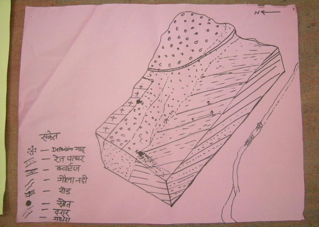
64 A 3-D layout
65 A 3-D layout
66 A 3-D layout
67 A 3-D layout

68 A 3-D layout
69 Tilt view in google earth

70 Tilt view in google earth

71 Tilt view in google earth
72 A geological layout
73 Spring Cross-section Map
Springshed Springshed Management Training Curriculum
 Springshed Springshed Management Training Curriculum Management Training Curriculum Draft Version 2 January 2016 The Springs Initiative 2016 The Springs Initiative SESSION TITLE: Mapping Springs in Crystalline
A. Refer to Appendix F in back of lab manual for list of commonly used geologic map symbols
 Structural Geology Lab 2: Outcrop Patterns and Structure Contours I. Geologic Map Symbols A. Refer to Appendix F in back of lab manual for list of commonly used geologic map symbols 1. Emphasis: a. strike
Stress and Strain. Stress is a force per unit area. Strain is a change in size or shape in response to stress
 Geologic Structures Geologic structures are dynamically-produced patterns or arrangements of rock or sediment that result from, and give information about, forces within the Earth Produced as rocks change
Chapter 15 Structures
 Chapter 15 Structures Plummer/McGeary/Carlson (c) The McGraw-Hill Companies, Inc. TECTONIC FORCES AT WORK Stress & Strain Stress Strain Compressive stress Shortening strain Tensional stress stretching
GEOLOGY 470 FIELD EXERCISE 3, SPRING SKETCHING, DESCRIBING, AND MAPPING EXPOSURES
 GEOLOGY 470 FIELD EXERCISE 3, SPRING 2009 -- SKETCHING, DESCRIBING, AND MAPPING EXPOSURES 1 OBJECTIVES: To develop and refine your field skills in: 1. observation and rock and sediment description 2. sketching
Topographic Maps and Landforms Geology Lab
 Topographic Maps and Landforms Geology Lab Ray Rector: Instructor Today s Lab Activities 1) Discussion of Last Week s Lab 2) Lecture on Topo Maps and Elevation Contours 3) Construct Topographic Maps and
Geological mapwork from scratch 2: valley with simple geology Draw your own cross sections and 3D geological model
 Geological mapwork scratch 2: valley with simple geology Draw your own cross sections and 3D geological model A valley with a stream looks like this: Modified the Geograph project collection. Copyright
Springshed Management Training Curriculum Authored by Springs Initiative partners
 Springshed Management Training Curriculum 2016 Authored by Springs Initiative partners Springshed Management Training Curriculum, Draft 2 SESSION TITLE: Rocks Hands-On Practical Session SECTION: Understanding
Lab 7: STRUCTURAL GEOLOGY FOLDS AND FAULTS
 Lab 7: STRUCTURAL GEOLOGY FOLDS AND FAULTS This set of labs will focus on the structures that result from deformation in earth s crust, namely folds and faults. By the end of these labs you should be able
GEOLOGY 435 FIELD EXERCISE 2, SPRING SKETCHING, DESCRIBING, AND MAPPING EXPOSURES OBJECTIVES:
 OBJECTIVES: GEOLOGY 435 FIELD EXERCISE 2, SPRING 2016 -- SKETCHING, DESCRIBING, AND MAPPING EXPOSURES To develop and refine your field skills in: 1. observation and rock and sediment description 2. sketching
Name. GEOL.5220 Structural Geology Faults, Folds, Outcrop Patterns and Geologic Maps. I. Properties of Earth Materials
 I. Properties of Earth Materials GEOL.5220 Structural Geology Faults, Folds, Outcrop Patterns and Geologic Maps Name When rocks are subjected to differential stress the resulting build-up in strain can
Geological mapwork from scratch 3: valley with dipping geology Draw your own cross sections and 3D geological model
 Geological mapwork from scratch 3: valley with dipping geology Draw your own cross sections and 3D geological model A valley with a river looks like this: The straight glen of the Allt Mhuic from its headwaters
EPS 50 Lab 6: Maps Topography, geologic structures and relative age determinations
 Name: EPS 50 Lab 6: Maps Topography, geologic structures and relative age determinations Introduction: Maps are some of the most interesting and informative printed documents available. We are familiar
GEOL 02: Historical Geology Lab 14: Topographic Maps. Name: Date:
 GEOL 02: Historical Geology Lab 14: Topographic Maps Name: Date: A topographic map is a two dimensional (flat) representation (model) of a three dimensional land surface (landscape). It shows landforms
Crustal Deformation. (Building Earth s Surface, Part 1) Science 330 Summer Mapping geologic structures
 Science 330 Summer Mapping geologic structures") Crustal Deformation (Building Earth s Surface, Part 1) Science 330 Summer 2005 Mapping geologic structures When conducting a study of a region, a geologist identifies and describes the dominant rock structures
Crustal Deformation (Building Earth s Surface, Part 1) Science 330 Summer 2005 Mapping geologic structures When conducting a study of a region, a geologist identifies and describes the dominant rock structures
EAS 233 Geologic Structures and Maps Winter Miscellaneous practice map exercises. 1. Fault and separation:
 Miscellaneous practice map exercises 1. Fault and separation: With respect to Map 1, what are (a) the orientation of the fault, and (b) the orientation of bedding in the units cut by the fault. (c) Mark
How mountains are made. We will talk about valleys (erosion and weathering later)
") How mountains are made We will talk about valleys (erosion and weathering later) http://www.ilike2learn.com/ilike2learn/mountainmaps/mountainranges.html Continent-continent plate convergence Less dense,
How mountains are made We will talk about valleys (erosion and weathering later) http://www.ilike2learn.com/ilike2learn/mountainmaps/mountainranges.html Continent-continent plate convergence Less dense,
Lecture 6 Folds, Faults and Deformation Dr. Shwan Omar
 Fold: A fold is a bend or wrinkle of rock layers or foliation; folds form as a sequence of ductile deformation. Folding is the processes by which crustal forces deform an area of crust so that layers of
Construction Technical Specifications on Rock-Foundation Excavating Engineering of Hydraulic Structures
 DL Electric Power Industry Standard of the People's Republic of China P DL I T 5389-- Construction Technical Specifications on Rock-Foundation Excavating Engineering of Hydraulic Structures DL/T 5389-
Structural Geology and Geology Maps Lab
 Structural Geology and Geology Maps Lab Mesa College Geology 101 Lab Ray Rector: Instructor Structural Geology Lab Pre-Lab Resources Pre-Lab Internet Links 1) Fundamentals of Structural Geology 2) Visualizing
UNIVERSITY OF NAIROBI COLLEGE OF EDUCATION AND EXTERNAL STUDIES & SCHOOL OF PHYSICAL SCIENCE DEPARTMENT OF GEOLOGY SGL 308:
 UNIVERSITY OF NAIROBI COLLEGE OF EDUCATION AND EXTERNAL STUDIES & SCHOOL OF PHYSICAL SCIENCE DEPARTMENT OF GEOLOGY SGL 308: INTRODUCTION TO GEOLOGICAL MAPPING WRITTEN BY Reviewed by: C.M. Nyamai, W.M.
Structural Geology Lab. The Objectives are to gain experience
 Geology 2 Structural Geology Lab The Objectives are to gain experience 1. Drawing cross sections from information given on geologic maps. 2. Recognizing folds and naming their parts on stereoscopic air
Team Name. Name(s) SSSS Unome Geologic Mapping Test Packet p1
 SSSS Unome Geologic Mapping Test Packet p1") Scioly Summer Study Session 2018-2019 Geologic Mapping Test Packet Written by Unome Instructions 1) This test is based on the 2016 rules for Geologic Mapping. 2) This test is out of 115 points. Questions
Scioly Summer Study Session 2018-2019 Geologic Mapping Test Packet Written by Unome Instructions 1) This test is based on the 2016 rules for Geologic Mapping. 2) This test is out of 115 points. Questions
Landforms and Rock Structure
 Landforms and Rock Structure Rock Structure as a Landform Control Landforms of Horizontal Strata and Coastal Plains Landforms of Warped Rock Layers Landforms Developed on Other Land-Mass Types Landforms
GEOL 220A Geologic Field Experiences: West Virginia Spring Term, 2008
 GEOL 220A Geologic Field Experiences: West Virginia Spring Term, 2008 Dr. Fred Soster Office: 216 Julian S&M e-mail: fsoster@depauw.edu Phone: 658-4670 Meeting Times: 2:15-3:15 p.m., Monday & Wednesday;
LAB 1: ORIENTATION OF LINES AND PLANES
 LAB 1: ORIENTATION OF LINES AND PLANES Read the introductory section, chapter 1, pages 1-3, of the manual by Rowland et al (2007) and make sure you understand the concepts of bearing, strike, dip, trend,
MAPS AND CROSS SECTIONS (I)
") GG303 Lab 3 8/27/09 1 MAPS AND CROSS SECTIONS (I) I Main Topics A Three point problems B Rule of vees C Map interpretation and cross sections II Three point problems (see handout) A Three points define
GG303 Lab 3 8/27/09 1 MAPS AND CROSS SECTIONS (I) I Main Topics A Three point problems B Rule of vees C Map interpretation and cross sections II Three point problems (see handout) A Three points define
Crustal Deformation Earth - Chapter Pearson Education, Inc.
 Crustal Deformation Earth - Chapter 10 Structural Geology Structural geologists study the architecture and processes responsible for deformation of Earth s crust. A working knowledge of rock structures
The University of Jordan. Accreditation & Quality Assurance Center. Course Name: Structural Geology COURSE Syllabus
 The University of Jordan Accreditation & Quality Assurance Center COURSE Syllabus Course Name: Structural Geology 0305341 1 Course title Structural Geology 2 Course number 0305341 3 Credit hours (theory,
Figure 2.1: Constituent Area
 2 The Region 2.1 CONSTITUENT AREA The National Capital Region includes NCT-Delhi, nine districts of Haryana, six districts of Uttar Pradesh and one district of Rajasthan. Total area of the region is 34,144
Finding Fault Geologic History from a Road Cut
 Finding Fault Geologic History from a Road Cut Elisabeth M. Price, DD LaPointe, and Jonathan G. Price 4 July 2005 Introduction Earth science is an important science to present to students because it directly
Deformation of Rocks. Orientation of Deformed Rocks
 Deformation of Rocks Folds and faults are geologic structures caused by deformation. Structural geology is the study of the deformation of rocks and its effects. Fig. 7.1 Orientation of Deformed Rocks
Geologic Mapping Invitational Trial Event
 Geologic Mapping Invitational Trial Event A TEAM OF UP TO: 2 Team Name AVAILABLE TIME: 50 min Required Materials: Each team MUST have a protractor, ruler, non-programmable calculator, colored pencils,
Chapter 6 Mapping and Online Tools
 Chapter 6 Mapping and Online Tools The stream site you monitor is just part of a much larger system. When analyzing stream health, it is important to take a holistic view by considering the entire watershed.
Structural Geology Lab. The Objectives are to gain experience
 Geology 2 Structural Geology Lab The Objectives are to gain experience 1. Drawing cross sections from information given on geologic maps. 2. Recognizing folds and naming their parts on stereoscopic air
Chapter 10: Deformation and Mountain Building. Fig. 10.1
 Chapter 10: Deformation and Mountain Building Fig. 10.1 OBJECTIVES Describe the processes of rock deformation and compare and contrast ductile and brittle behavior in rocks. Explain how strike and dip
Structural Geology, GEOL 330 Spring 2012
 Developing the Magic Eye for folds This lab exercise is designed to get you thinking about the chronology of structural processes and and the resultant map patterns in areas with flat topography. You may
GLY 155 Introduction to Physical Geology, W. Altermann. Press & Siever, compressive forces. Compressive forces cause folding and faulting.
 Press & Siever, 1995 compressive forces Compressive forces cause folding and faulting. faults 1 Uplift is followed by erosion, which creates new horizontal surface. lava flows Volcanic eruptions cover
6. 地質圖 6.1 岩層於地形圖上的分布 6.2 地質剖面圖 6.3 地質圖判識 地調所五萬分之一地質圖台中圖幅
 6. 地質圖 6.1 岩層於地形圖上的分布 6.2 地質剖面圖 6.3 地質圖判識 A geological shows how geological features (rock units, faults, etc.) are distributed across a region. It is a twodimensional representation of part of the Earth
COOMALIE RIDGES RADIOMETRIC SURVEY, RUM JUNGLE AREA,
 COMMONWEALTH OF AUSTRALIA DEPARTMENT OF NATIONAL DEVELOPMENT BUREAU OF MINERAL RESOURCES, GEOLOGY AND GEOPHYSICS RECORD No. 1966/51 500917 COOMALIE RIDGES RADIOMETRIC SURVEY, RUM JUNGLE AREA, NORTHERN
Evaluation of Structural Geology of Jabal Omar
 International Journal of Engineering Research and Development e-issn: 2278-067X, p-issn: 2278-800X, www.ijerd.com Volume 11, Issue 01 (January 2015), PP.67-72 Dafalla Siddig Dafalla * and Ibrahim Abdel
Geologic Mapping Regional Tournament Trial Event
 Geologic Mapping Regional Tournament Trial Event A TEAM OF UP TO: 2 Team Name AVAILABLE TIME: 50 min Required Materials: Each team MUST have a protractor, ruler, non-programmable calculator, colored pencils,
UNIT 1C. USING TOPOGRAPHIC MAPS WHERE IN THE WORLD... ARE YOU?
 UNIT 1C. USING TOPOGRAPHIC MAPS WHERE IN THE WORLD... ARE YOU? TIME 60-90 minutes LEVEL All BENCHMARKS Next Generation Science Standards MS-LS1.D Science & Engineering Practices Developing and Using Models
Blocks Module Content Guide
 Blocks Module Content Guide This guide covers the basics of the content within the Interactive 3D Geologic Blocks Module. The content guide is intended to assist you, the teacher, in creating effective
Lecture Outline Friday March 2 thru Wednesday March 7, 2018
 Lecture Outline Friday March 2 thru Wednesday March 7, 2018 Questions? Lecture Exam Friday March 9, 2018 Same time, Same room Bring Pencils and WSU ID 50 question Multiple Choice, Computer Graded Interlude
Staple this part to part one of lab 6 and turn in. Lab 6, part two: Structural geology (analysis)
") Geology 101 Staple this part to part one of lab 6 and turn in Lab 6, part two: Structural geology (analysis) Recall that the objective of this lab is to describe the geologic structures of Cougar Mountain
Geology 101 Staple this part to part one of lab 6 and turn in Lab 6, part two: Structural geology (analysis) Recall that the objective of this lab is to describe the geologic structures of Cougar Mountain
CRUSTAL DEFORMATION. Chapter 10
 CRUSTAL DEFORMATION and dgeologic Structures t Chapter 10 Deformation Df Deformation involves: Stress the amount of force applied to a given area. Types of Stress: Confining Stress stress applied equally
Answer sheet for question 1 Answer question 1 as soon as the sample arrives at your desk.
 EAS 233 Geologic structures. Final test. April 2012. 3 hours. Answer question 1 and 2 and three other questions. If you start more than the required number of questions, clearly delete the answers you
Theme 7. Metamorphic rocks. Distinguishing rock types
 Theme 7. Metamorphic rocks. Distinguishing rock types 7.1. Metamorphic rocks formation 7.2. Classification of metamorphic rocks 7.3. Distinguishing rock types 7.1. Metamorphic rocks formation 7.1. Metamorphic
Lecture 9 faults, folds and mountain building
 Lecture 9 faults, folds and mountain building Rock deformation Deformation = all changes in size, shape, orientation, or position of a rock mass Structural geology is the study of rock deformation Deformation
Geology : Embedded Inquiry
 Geology : Embedded Inquiry Conceptual Strand Understandings about scientific inquiry and the ability to conduct inquiry are essential for living in the 21 st century. Guiding Question What tools, skills,
FIELD GEOLOGY AND GEOLOGIC MAPPING TECHNIQUES Geology Fall Semester 2007 Dr. Randy L. Kath, P.G.
 FIELD GEOLOGY AND GEOLOGIC MAPPING TECHNIQUES Geology 3004-01 Fall Semester 2007 Dr. Randy L. Kath, P.G. rkath@westga.edu General Outline (subject to change) I. General Principles and Techniques 1) Philosophy
Faults, folds and mountain building
 Faults, folds and mountain building Mountain belts Deformation Orogens (Oro = Greek all changes for mountain, in size, shape, genesis orientation, = Greek for or formation) position of a rock mass Structural
Chapter 3 SECTION 1 OBJECTIVES
 Chapter 3 SECTION 1 OBJECTIVES Distinguish between latitude and longitude and locate coordinates on maps. Explain how latitude and longitude can be used to locate places on Earth s surface. Explain the
Crags, Cracks, and Crumples: Crustal Deformation and Mountain Building
 Crags, Cracks, and Crumples: Crustal Deformation and Mountain Building Updated by: Rick Oches, Professor of Geology & Environmental Sciences Bentley University Waltham, Massachusetts Based on slides prepared
UNIT 10 MOUNTAIN BUILDING AND EVOLUTION OF CONTINENTS
 UNIT 10 MOUNTAIN BUILDING AND EVOLUTION OF CONTINENTS ROCK DEFORMATION Tectonic forces exert different types of stress on rocks in different geologic environments. STRESS The first, called confining stress
EPSS 15. Spring Introduction to Oceanography. Laboratory #1 Maps, Cross-sections, Vertical Exaggeration, Graphs, and Contour Skills 4/7/17
 EPSS 15 Spring 2017 Introduction to Oceanography Laboratory #1 Maps, Cross-sections, Vertical Exaggeration, Graphs, and Contour Skills MAPS Provide valuable interface to explore the geography of the world
PLANE AND ATTITUDE OF STRATA
 2307216 Field Methods in Geology I PLANE AND ATTITUDE OF STRATA ผ ช วยศาสตราจารย ดร.ว ช ย จ ฑะโกส ทธ กานนท ภาคว ชาธรณ ว ทยา คณะว ทยาศาสตร จ ฬาลงกรณ มหาว ทยาล ย vichaic@yahoo.com Outline Basic knowledge
Interactive 3D Sketchupbook
 THE UNIVERSITY OF SYDNEY - SCHOOL OF GEOSCIENCES Interactive 3D Sketchupbook Patrice F. Rey CHAPTER 1 Orienting Planes and Lines 1 Interactive 1.1 Strike, dip and dip direction In a 3D space, planar surfaces
Structural Geology, GEOL 330 Fold mapping lab: Even folds get parasites Spring, 2012
 Structural Geology, GEOL 330 Name: Fold mapping lab: Even folds get parasites Spring, 2012 This exercise is meant to mimic a field experience in which you, the student, will measure beddingcleavage relationships
How to Build a Mountain and other Geologic Structures. But first a short review
 How to Build a Mountain and other Geologic Structures But first a short review Where do we see deep earthquakes? What is happening there? What can happen at a plate boundary? 1. Plates can move apart
Chapter 8: Geological Structures. Part 1: Strike, Dip, and Structural Cross-Sections
 Chapter 8: Geological Structures Part 1: Strike, Dip, and Structural Cross-Sections Adapted by Karla Panchuk, Joyce M. McBeth, Lyndsay R. Hauber, & Michael B. Cuggy (2018) University of Saskatchewan from
Part I. PRELAB SECTION To be completed before labs starts:
 Student Name: Physical Geology 101 Laboratory #13 Structural Geology II Drawing and Analyzing Folds and Faults Grade: Introduction & Purpose: Structural geology is the study of how geologic rock units
MAPPING POTENTIAL LAND DEGRADATION IN BHUTAN
 MAPPING POTENTIAL LAND DEGRADATION IN BHUTAN Moe Myint, Geoinformatics Consultant Rue du Midi-8, CH-1196, Gland, Switzerland moemyint@bluewin.ch Pema Thinley, GIS Analyst Renewable Natural Resources Research
Lab 6: Plate tectonics, structural geology and geologic maps
 Geology 103 Name(s): Lab 6: Plate tectonics, structural geology and geologic maps Objective: To show the effects of plate tectonics on a large-scale set of rocks and to reconstruct the geological history
Geology 101 Lab Worksheet: Geologic Structures
 Name: Geology 101 Lab Worksheet: Geologic Structures Refer to the Geologic Structures Lab for the information you need to complete this worksheet (http://commons.wvc.edu/rdawes/g101ocl/labs/structurelab.html).
How to Build a Mountain and other Geologic Structures. But first, questions
 How to Build a Mountain and other Geologic Structures But first, questions Questions your students might ask How were Montana s mountains formed? How old are the mountains? What are the different ways
APPENDIX A GLOSSARY. Appendix A.1
 APPENDIX A GLOSSARY Appendix A.1 Appendix A.2 Back Bearing A back bearing is measured from the object to your position. It is the exact opposite of a direct bearing. Base Line An imaginary line on the
2 Geology. 2.1 Elements of Terrane Analysis. Terrane or Terrain? Potential receptors
 2 Geology Knowledge of fractured rock geology, or terrane, provides important context for investigating contaminated sites. Tectonic forces impart characteristic structures on rock formations that influence
Directed Reading. Section: Types of Maps
 Skills Worksheet Directed Reading Section: Types of Maps 1. What are some of the characteristics of an area shown on maps used by Earth scientists? a. types of animals, types of plants, types of minerals
KEY CHAPTER 12 TAKE-HOME QUIZ INTERNAL STRUCTURES AND PROCESSES Score Part B = / 55 PART B
 GEOLOGY 12 KEY CHAPTER 12 TAKE-HOME QUIZ INTERNAL STRUCTURES AND PROCESSES Score Part B = / 55 PART B CHAPTER 12 Isostacy and Structural Geology 1. Using the terms below, label the following diagrams and
13 Watershed Delineation & Modeling
 Module 4 (L12 - L18): Watershed Modeling Standard modeling approaches and classifications, system concept for watershed modeling, overall description of different hydrologic processes, modeling of rainfall,
Dip-Sequence Analysis
 Chapter 9 Dip-Sequence Analysis 9.1 Introduction The three-dimensional geometry of a structure can be determined from the bedding attitudes measured in a single well bore or on a traverse through a structure.
Using Map and Compass Together
 Using Map and Compass Together In situations where you foresee a potential evacuation on foot, where there are no roads, and no indication as to the direction of travel (i.e., road signs), it is recommended
Ge Problem Set 1
 Ge 101 2012 Problem Set 1 This problem set covers basic techniques in structural geology, geomorphology and the construction of cross sections. Questions 2 and 3 are simple exercises; 1 and 4 are reallife
L A N D F O R M S W E D N E S D A Y
 E P S C 2 4 0 : G E O L O G Y I N T H E F I E L D L A N D F O R M S W E D N E S D A Y Google Earth/Mars lab Laptops Install Google Earth Pro Île Sainte Hélène report due Return mineral ID kits (for non-mineralogy
Geomorphology Final Exam Study Guide
 Geomorphology Final Exam Study Guide Geologic Structures STRUCTURAL GEOLOGY concerned with shapes, arrangement, interrelationships of bedrock units & endogenic (within) forces that cause them. Tectonic
N30 E-45 SE S25 E-10 SW N85 W-80 NE
 Geologic aps and tructures Name Geology 100 Harbor section Read h. 7 before you begin. The objectives of this lab are for you to learn the basic geologic structures in 3- and to develop some facility in
Structural Geology Laboratory.
 Structural Geology Wikipedia-Structural geology is the study of the threedimensional distribution of rock units with respect to their deformational histories. The primary goal of structural geology is
Crustal Deformation. Earth Systems 3209
 Crustal Deformation Earth Systems 3209 Crustal Deformation pg. 415 Refers to all changes in the original form and/or size of a rock body. May also produce changes in the location and orientation of rocks.
Geological mapwork: using surface geology to make a geological map Match the photos to a map to see how a geological map works
 eological mapwork: using surface geology to make a geological map Match the photos to a map to see how a geological map works For each of the photographs: 1. Draw straight lines to link each photograph
Tuesday 15 January 2013 Afternoon
 Tuesday 15 January 2013 Afternoon AS GCE GEOLOGY F791/01 Global Tectonics *F712950113* Candidates answer on the Question Paper. OCR supplied materials: None Other materials required: Ruler (cm/mm) Protractor
SSSS Unome Geologic Mapping Answer Key p1
 Scioly Summer Study Session 2018-2019 Geologic Mapping Answer Key Written by Unome Instructions Because this test is written for SSSS, the answer key includes explanations for most questions. It is also
UNDERSTANDING GEOLOGIC M APS
 Name: Lab Section: work in groups, but each person turns in his/her own GEOSCIENCE 001 L AB UNDERSTANDING GEOLOGIC M APS Geologic maps are colorful and even beautiful, but they also contain an amazing
In this lab, we will study and analyze geologic maps from a few regions, including the Grand Canyon, western Wyoming, and coastal California.
 Name: Lab Section: work in groups, but each person turns in his/her own GEOSCIENCE 001 LAB UNDERSTANDING GEOLOGIC MAPS Geologic maps are colorful and even beautiful, but they also contain an amazing amount
NAME HOMEWORK ASSIGNMENT #3 MATERIAL COVERS CHAPTERS 8, 9, 10, 11
 NAME HOMEWORK ASSIGNMENT #3 MATERIAL OVERS HAPTERS 8, 9, 10, 11 Assignment is due the beginning of the class period on November 23, 2004. Answers for each chapter will be discussed in class, as Exam #3
GG303 Lab 5 10/4/17 1
 GG303 Lab 5 10/4/17 1 Lab 5 Spherical Projections Use a separate piece of paper for each exercise, and include printouts of your Matlab work. 103 pts for Ex. 1-4; 124 points for Ex. 1-5. Exercise 1: Plots
1.72, Groundwater Hydrology Prof. Charles Harvey Lecture Packet #5: Groundwater Flow Patterns. Local Flow System. Intermediate Flow System
 1.72, Groundwater Hydrology Prof. Charles Harvey Lecture Packet #5: Groundwater Flow Patterns c Local Flow System 10,000 feet Intermediate Flow System Regional Flow System 20,000 feet Hydrologic section
CHAPTER 6, PRELIMINARY SITE INVESTIGATION CONTENTS
 CHAPTER 6, PRELIMINARY SITE INVESTIGATION CONTENTS - Page Purpose... 6-1 Assembly of data... 6-1 Use of aerial photographs... 6-2 Field study... 6-3 Mappix... 6-4 Repcrt of preliminary investigation...
Structural Analysis and Tectonic Investigation of Chamshir Dam Site, South West Zagros
 Open Journal of Geology, 2015, 5, 136-143 Published Online March 2015 in SciRes. http://www.scirp.org/journal/ojg http://dx.doi.org/10.4236/ojg.2015.53013 Structural Analysis and Tectonic Investigation
Lab Final Review 4/16/18
 Lab Final Review 4/16/18 Overall goals from lab Think about geology on recent timescales, predict the direction change Be able to identify how different landforms or patterns (e.g. drainage patterns, dune
Downloaded from Downloaded from
 IV SEMESTER BACK-PAPER EXAMINATION-2004 Q. [1] [a] Describe internal structure of the earth with a neat sketch. Write down the major land forms and their characteristics on the earth surface. [8] [b] What
SIXTH SCHEDULE REPUBLIC OF SOUTH SUDAN MINISTRY OF PETROLEUM, MINING THE MINING (MINERAL TITLE) REGULATIONS 2015
 REGULATIONS 2015") SIXTH SCHEDULE REPUBLIC OF SOUTH SUDAN MINISTRY OF PETROLEUM, MINING THE MINING ACT, 2012 THE MINING (MINERAL TITLE) REGULATIONS 2015 Guidelines should be prepared by the Directorate of Mineral Development
SIXTH SCHEDULE REPUBLIC OF SOUTH SUDAN MINISTRY OF PETROLEUM, MINING THE MINING ACT, 2012 THE MINING (MINERAL TITLE) REGULATIONS 2015 Guidelines should be prepared by the Directorate of Mineral Development
Detailed Low-Induction-Number EM Sounding to 9-m Depth
 Detailed Low-Induction-Number EM Sounding to 9-m Depth Richard S. Taylor, Dualem Inc. J. Scott Holladay, Geosensors Inc. David Lalonde, Geosensors Inc. SAGEEP, Charleston SC, April 11 Copyright 11, Dualem
Student Name: 1) 2) GeoLogic Mapping. UNL - May 16, Event supervisor: Enrica Quartini
 2) GeoLogic Mapping. UNL - May 16, Event supervisor: Enrica Quartini") School Name: Team # Student Name: 1) 2) GeoLogic Mapping National Science Olympiad Tournament UNL - May 16, 2015 Event supervisor: Enrica Quartini staff.aist.go.jp Ø All answers must be reported clearly
School Name: Team # Student Name: 1) 2) GeoLogic Mapping National Science Olympiad Tournament UNL - May 16, 2015 Event supervisor: Enrica Quartini staff.aist.go.jp Ø All answers must be reported clearly
Topographic metrics and bedrock channels Outline of this lecture
 Topographic metrics and bedrock channels Outline of this lecture Topographic metrics Fluvial scaling and slope-area relationships Channel steepness sensitivity to rock uplift Advancing understanding of
Field Trip to Tempe Butte
 Synopsis Field Trip to Tempe Butte So far you have been identifying rocks and mapping their locations without actually going there. Now it is your chance to put it all together and see real rocks out in
Paper models in geography teaching Author(s) Merrick, Brian Source Teaching and Learning, 12(1),58-67 Published by Institute of Education (Singapore)
 Merrick, Brian Source Teaching and Learning, 12(1),58-67 Published by Institute of Education (Singapore)") Title Paper models in geography teaching Author(s) Merrick, Brian Source Teaching and Learning, 12(1),58-67 Published by Institute of Education (Singapore) This document may be used for private study or
Title Paper models in geography teaching Author(s) Merrick, Brian Source Teaching and Learning, 12(1),58-67 Published by Institute of Education (Singapore) This document may be used for private study or
What Causes Rock to Deform?
 Crustal Deformation Earth, Chapter 10 Chapter 10 Crustal Deformation What Causes Rock to Deform? Deformation is a general term that refers to all changes in the shape or position of a rock body in response
Stratigraphic Cross-Section
 Stratigraphic cross-sections are used to show stratigraphic relationships of strata along some path. They differ from structural cross-sections in three ways. First, their goals differ. Stratigraphic cross-sections