Topographic metrics and bedrock channels Outline of this lecture
|
|
|
- Tyler Perkins
- 5 years ago
- Views:
Transcription
1 Topographic metrics and bedrock channels Outline of this lecture Topographic metrics Fluvial scaling and slope-area relationships Channel steepness sensitivity to rock uplift Advancing understanding of geomorphology with topographic analysis emphasizing high resolution topography June 12-15, 2017
2 Topographic Metrics Many Topographic metrics have been proposed. We ll examine the three most common Channel Steepness Index Hillslope Gradients Local Relief at Various Scales Chi (Bodo lecture) What are the relationships among these? Which are most useful for gaging the influence of tectonics on topography? Advancing understanding of geomorphology with topographic analysis emphasizing high resolution topography June 12-15, 2017

3 80-90% Relief is on Bedrock Channels Blue lines: drainage area > 1km 2 Advancing understanding of geomorphology with topographic analysis emphasizing high resolution topography June 12-15, 2017

 and log(a) k s is the channel steepness; θ")
4 Fluvial Scaling Empirical Data Empirical data for well-adjusted fluvial systems around the globe yield the following scaling: S = k s A -θ Linear relationship between log(s) and log(a) k s is the channel steepness; θ is the concavity
5 Flint s Law: Mixed Bedrock-Alluvial Stream (Appalachians, VA)

6 Flint s Law: Mixed Bedrock-Alluvial Stream (Appalachians, VA) S = k s A -θ colluvial reach -θ k s k s is a general morphometric index: No dependence on basin shape
 invariant with U θ = m/n S = k s A -θ Steepness (Ks) varies with U k")
7 Duvall, Kirby, and Burbank, 2004, JGR-ES U = Rock Uplift Rate Concavity (θ) invariant with U θ = m/n S = k s A -θ Steepness (Ks) varies with U k s

8 Siwalik Hills, Nepal
9


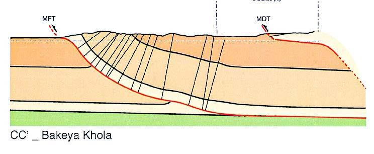
10 Bagmati Transect Bakeya Transect Data from Lave and Avouac, 2000, JGR
11 Siwalik Hills Anticline Himalaya Foreland, Nepal Strike-Parallel: Uniform Uplift Along Stream
12 Strike-Parallel: Normal, uniform concavity 14 mm/yr 7 mm/yr Strike-Parallel: Steepness varies with U
 varies")
13 Siwalik Hills, Nepal Steepness (Ks) varies with U

14 Tectonic Geomorphology of the San Gabriel Mountains


15 Shaded Relief with Color = Elevation rtm_bigtujunga30m_utm11.tif Active Faults Thickness = Most Recent Known Slip

 as")
16 Beware: Many authors use hillslope relief and local relief (measured over up to 5km radius) as interchangeable
 Note: abrupt steepness breaks across active faults, no break where")
17 Streams by Normalized Steepness Index Local Relief (r = 2.5km) Note: abrupt steepness breaks across active faults, no break where inactive/slow
18

19 The old way. Now we use TopoToolbox!

20 Advancing understanding of geomorphology with topographic analysis emphasizing high resolution topography June 12-15, 2017
21 Channel steepness considerations By evaluating slope-area regressions using a reference concavity index (θ ref ), one can determine a normalized steepness index (k sn ) that allows effective comparison of profiles of streams with greatly varying drainage area (Wobus, et al., 2006) Stream-power family of incision models (E is erosion rate, K is a generalized rate constant, A is drainage area, and S is local slope) Kirby and Whipple, 2012 Advancing understanding of geomorphology with topographic analysis emphasizing high resolution topography June 12-15, 2017
22 Channel steepness considerations At steady state, by definition the channel erosion rate is equal to the uplift rate of rock (E = U), and the steady-state channel gradient(s e ) is Recall: predicts θ ~ ½, consistent with observations for well-graded channels with uniform K and U (0.4 < θ < 0.6) And thus we assume, K sn ~ U p (rock uplift rate) all other things (like climate, vegetation, and rock resistance to erosion, [that is K], being roughly equal) Kirby and Whipple, 2012 Advancing understanding of geomorphology with topographic analysis emphasizing high resolution topography June 12-15, 2017
23 It is only a metric, don t apply it blindly! Kirby and Whipple, 2012 Advancing understanding of geomorphology with topographic analysis emphasizing high resolution topography June 12-15, 2017
24 Kirby and Whipple, 2012 Advancing understanding of geomorphology with topographic analysis emphasizing high resolution topography June 12-15, 2017
25 Transient channel response and knickpoints Migrating boundaries between downstream region adjusting to new forcing (e.g., baselevel drop) and upstream region adjusted to prior state Kirby and Whipple, 2012 Advancing understanding of geomorphology with topographic analysis emphasizing high resolution topography June 12-15, 2017
26 Interpretation of transient profiles Kirby and Whipple, 2012 Advancing understanding of geomorphology with topographic analysis emphasizing high resolution topography June 12-15, 2017


27 Saline Valley, California example Implies change in fault throw rate Kirby and Whipple, 2012 Advancing understanding of geomorphology with topographic analysis emphasizing high resolution topography June 12-15, 2017
Down-stream process transition (f (q s ) = 1)
 = 1)") Down-stream process transition (f (q s ) = 1) Detachment Limited S d >> S t Transport Limited Channel Gradient (m/m) 10-1 Stochastic Variation { Detachment Limited Equilibrium Slope S d = k sd A -θ d S
Down-stream process transition (f (q s ) = 1) Detachment Limited S d >> S t Transport Limited Channel Gradient (m/m) 10-1 Stochastic Variation { Detachment Limited Equilibrium Slope S d = k sd A -θ d S
1. From raw topographic data to a river long-profile analysis. At the Matlab prompt, type. DEM = GRIDobj('srtm_bigtujunga30m_utm11.
 Earth and Planetary Surface Processes Winter 2017 - Lab 4. River channel long profiles. Wieboldt 310C, 10:30a-11:20a Grades are not assigned for lab, but attendance is required. If you are unable to make
Determination of uplift rates of fluvial terraces across the Siwaliks Hills, Himalayas of central Nepal
 Determination of uplift rates of fluvial terraces across the Siwaliks Hills, Himalayas of central Nepal Martina Böhme Institute of Geology, University of Mining and Technology, Freiberg, Germany Abstract.
Drainage Basin Geomorphology. Nick Odoni s Slope Profile Model
 Drainage Basin Geomorphology Nick Odoni s Slope Profile Model Odoni s Slope Profile Model This model is based on solving the mass balance (sediment budget) equation for a hillslope profile This is achieved
mountain rivers fixed channel boundaries (bedrock banks and bed) high transport capacity low storage input output
 high transport capacity low storage input output") mountain rivers fixed channel boundaries (bedrock banks and bed) high transport capacity low storage input output strong interaction between streams & hillslopes Sediment Budgets for Mountain Rivers Little
mountain rivers fixed channel boundaries (bedrock banks and bed) high transport capacity low storage input output strong interaction between streams & hillslopes Sediment Budgets for Mountain Rivers Little
Tectonics from topography: Procedures, promise, and pitfalls
 Geological Society of merica Special Paper 398 26 Tectonics from topography: Procedures, promise, and pitfalls Cameron Wobus Kelin X. Whipple Department of Earth, tmospheric and Planetary Sciences, Massachusetts
Preservation or Piracy: Diagnosing low relief, high elevation surface formation mechanisms. Supplemental Methods: Additional methodological details.
 GSA Data Repository 2017023 Preservation or Piracy: Diagnosing low relief, high elevation surface formation mechanisms Kelin X. Whipple 1, Roman A. DiBiase 2, William B. Ouimet 3, Adam M. Forte 1 Contents
Supplementary material
 GSA DATA REPOSITORY2014088 Supplementary material Dominance of tectonics over climate in Himalayan denudation Vincent Godard, Didier L. Bourlès, Françoise Spinabella, Douglas W. Burbank, Bodo Bookhagen,
An integral approach to bedrock river profile analysis
 1 An integral approach to bedrock river profile analysis 2 3 J. Taylor Perron and Leigh Royden 4 5 6 Department of Earth, Atmospheric and Planetary Sciences, Massachusetts Institute of Technology, Cambridge
Sensitivity analysis and parameter space exploration
 GSA Data Repository 2018013 Gray et al., 2018, Off-fault deformation rate along the southern San Andreas fault at Mecca Hills, southern California, inferred from landscape modeling of curved drainages:
User Guide to TopoToolbox - Plotting ksn-values
 User Guide to TopoToolbox - Plotting ksn-values Background... 1 Load and generate required data... 2 Calculating the concavity index... 4 Calculate and plot ksn values... 4 Aggregate ksn values in stream
Sediments and bedrock erosion
 Eroding landscapes: fluvial processes Sediments and bedrock erosion Mikaël ATTAL Marsyandi valley, Himalayas, Nepal Acknowledgements: Jérôme Lavé, Peter van der Beek and other scientists from LGCA (Grenoble)
GSA DATA REPOSITORY Sternai et al. 1. Algorithm Flow Chart
 GSA DATA REPOSITORY 2012311 Sternai et al. 1. Algorithm Flow Chart Figure DR1: Flow chart of the algorithm to further clarify the calculation scheme. 2. Reconstruction of the Pre-Glacial Alpine Topography
Durham E-Theses. The eects of dierential uplift and sediment supply on major Himalayan river systems at the mountain front DINGLE, ELIZABETH
 Durham E-Theses The eects of dierential uplift and sediment supply on major Himalayan river systems at the mountain front DINGLE, ELIZABETH How to cite: DINGLE, ELIZABETH (2012) The eects of dierential
Notice that the Grand Canyon is a knickpoint on the long profile. Cartoon examples of knickpoint migration:
 Earth and Planetary Surface Processes Winter 2017 - Lab 5. River channel long profiles. Hinds 440, 10:30a-11:20a Grades are not assigned for lab, but attendance is required. If you are unable to make a
Lab Final Review 4/16/18
 Lab Final Review 4/16/18 Overall goals from lab Think about geology on recent timescales, predict the direction change Be able to identify how different landforms or patterns (e.g. drainage patterns, dune
Numerical study of degradation of fluvial hanging valleys due to climate change
 Click Here for Full Article JOURNAL OF GEOPHYSICAL RESEARCH, VOL. 114,, doi:10.1029/2007jf000965, 2009 Numerical study of degradation of fluvial hanging valleys due to climate change Joseph K. Goode 1
Implications of the Saltation Abrasion Bedrock Incision Model for Steady-State River Longitudinal Profile Relief and Concavity
 Earth Surface Processes and Landforms Steady-State Earth Surf. Process. Bedrock Landforms River Longitudinal 33, 1129 1151 Profile (2008) Relief and Concavity 1129 Published online in Wiley InterScience
American Journal of Science
 [American Journal of Science, Vol. 301, April/May, 2001, P.313 325] American Journal of Science APRIL/MAY 2001 FLUVIAL LANDSCAPE RESPONSE TIME: HOW PLAUSIBLE IS STEADY-STATE DENUDATION? KELIN X. WHIPPLE
Abstract. landscapes with uniform and non-uniform rainfall. In the third major chapter, I employ the CHILD
 Abstract The interactions and feedbacks among climate, tectonics and surface erosion are complex but fundamental in geomorphological studies, and the mechanisms that control these processes are still not
Tectonic and lithologic controls on bedrock channel profiles and processes in coastal California
 JOURNAL OF GEOPHYSICAL RESEARCH, VOL. 109,, doi:10.1029/2003jf000086, 2004 Tectonic and lithologic controls on bedrock channel profiles and processes in coastal California Alison Duvall 1 Department of
Active Tectonics. Earthquakes, Uplift, and Landscape. Edward A. Keller University of California, Santa Barbara
 Prentice Hall Earth Science Series SUB Gottingen 214 80416X, im ^, 2002 A 7883 lllllllilwii Active Tectonics Earthquakes, Uplift, and Landscape Second Edition V Edward A. Keller University of California,
The role of waterfalls and knickzones in controlling the style and pace of landscape adjustment in the western San Gabriel Mountains, California
 The role of waterfalls and knickzones in controlling the style and pace of landscape adjustment in the western San Gabriel Mountains, California Roman A. DiBiase 1,,, Kelin X Whipple 2, Michael P. Lamb
Modeling fluvial incision and transient landscape evolution: Influence of dynamic channel adjustment
 JOURNAL OF GEOPHYSICAL RESEARCH, VOL. 113,, doi:10.1029/2007jf000893, 2008 Modeling fluvial incision and transient landscape evolution: Influence of dynamic channel adjustment M. Attal, 1 G. E. Tucker,
NERC Geophysical Equipment Pool Project 831 Scientific Report. Longitudinal river profile development and landscape response in NW Argentina
 NERC Geophysical Equipment Pool Project 831 Scientific Report Ruth A.J. Robinson School of Geography & Geosciences, University of St Andrews, St Andrews, KY16 9AL, UK Longitudinal river profile development
Geomorphology: Mechanics and Evolution of Landscapes (GES )
") Geomorphology: Mechanics and Evolution of Landscapes (GES 206.2.5401) Instructor: Itai Haviv, haviv@bgu.ac.il, room 331, building 58, office hours: Tuesday 11:15-13:15 Teaching assistant: May-Tal Sadeh,
Geomorphology: Mechanics and Evolution of Landscapes (GES 206.2.5401) Instructor: Itai Haviv, haviv@bgu.ac.il, room 331, building 58, office hours: Tuesday 11:15-13:15 Teaching assistant: May-Tal Sadeh,
Distribution of active rock uplift along the eastern margin of the Tibetan Plateau: Inferences from bedrock channel longitudinal profiles
 JOURNAL OF GEOPHYSICAL RESEARCH, VOL. 108, NO. B4, 2217, doi:10.1029/2001jb000861, 2003 Distribution of active rock uplift along the eastern margin of the Tibetan Plateau: Inferences from bedrock channel
Avoiding Geohazards in the Mid-Atlantic Highlands by Using Natural Stream Principles
 Avoiding Geohazards in the Mid-Atlantic Highlands by Using Natural Stream Principles J. Steven Kite, WVU Neal Carte, WVDOT Will Harman, Michael Baker Corp. Donald D. Gray, WVU Photo: W. Gillespie North
Sensitivity of channel profiles to precipitation properties in mountain ranges
 JOURNAL OF GEOPHYSICAL RESEARCH, VOL. 111,, doi:10.1029/2004jf000164, 2006 Sensitivity of channel profiles to precipitation properties in mountain ranges Shiliang Wu, 1 Rafael L. Bras, 2 and Ana P. Barros
Erosion Surface Water. moving, transporting, and depositing sediment.
 + Erosion Surface Water moving, transporting, and depositing sediment. + Surface Water 2 Water from rainfall can hit Earth s surface and do a number of things: Slowly soak into the ground: Infiltration
Bedrock channel geometry along an orographic rainfall gradient in the upper Marsyandi River valley in central Nepal
 San Jose State University From the SelectedWorks of Emmanuel J. Gabet July 25, 2007 Bedrock channel geometry along an orographic rainfall gradient in the upper Marsyandi River valley in central Nepal William
Fluvial archives, a valuable record of vertical crustal deformation
 *Manuscript Click here to view linked References 1 2 3 4 5 6 7 8 9 10 11 12 13 14 15 16 17 18 19 20 21 22 23 24 25 26 27 28 29 30 31 32 33 34 35 36 37 38 39 40 41 42 43 44 45 Fluvial archives, a valuable
GSA Data Repository Item DR Topographic advection on fault-bend folds: Inheritance of valley positions and the formation of wind gaps
 GSA Data Repository Item DR006161 Topograpic advection on fault-bend folds: Ineritance of valley positions and te formation of wind gaps S.R. Miller and R.L. Slingerland Department of Geosciences, Pennsylvania
Characterizing the Recent Cenozoic Erosional History of the Alleghany Front through Spatial Variation in Stream Profile Metrics
 Characterizing the Recent Cenozoic Erosional History of the Alleghany Front through Spatial Variation in Stream Profile Metrics Al Neely ABSTRACT Although the east coast of North America has been a passive
Streams. Stream Water Flow
 CHAPTER 14 OUTLINE Streams: Transport to the Oceans Does not contain complete lecture notes. To be used to help organize lecture notes and home/test studies. Streams Streams are the major geological agents
Continental Landscapes
 Continental Landscapes Landscape influenced by tectonics, climate & differential weathering Most landforms developed within the last 2 million years System moves toward an equilibrium Continental Landscapes
Knickpoint and knickzone formation and propagation, South Fork Eel River, northern California
 Geosphere Knickpoint and knickzone formation and propagation, South Fork Eel River, northern California Melissa A. Foster and Harvey M. Kelsey Geosphere published online 15 February 01; doi: 10.1130/GES00700.1
Investigating Controls on Bedrock River Incision Using Natural and Laboratory Experiments. Alexander C. Whittaker M.A. (cantab) MSci.
 MSci.") Investigating Controls on Bedrock River Incision Using Natural and Laboratory Experiments Alexander C. Whittaker M.A. (cantab) MSci. Thesis submitted for the degree of Doctor of Philosophy University of
Investigating Controls on Bedrock River Incision Using Natural and Laboratory Experiments Alexander C. Whittaker M.A. (cantab) MSci. Thesis submitted for the degree of Doctor of Philosophy University of
Edinburgh Research Explorer
 Edinburgh Research Explorer A statistical framework to quantify spatial variation in channel gradients using the integral method of channel profile analysis Citation for published version: Mudd, SM, Attal,
Correlating River Steepness with Erosion Rate along the Sri Lankan Escarpment. Matthew Potako
 1 Correlating River Steepness with Erosion Rate along the Sri Lankan Escarpment Matthew Potako ABSTRACT A recent body of work has utilized cosmogenic isotopes as a measure of erosion rate in efforts to
Effects of transient topography and drainage basin evolution on detrital thermochronometer data
 UNIVERSITY OF MICHIGAN Effects of transient topography and drainage basin evolution on detrital thermochronometer data Contents Acknowledgments...3 Abstract...4 1. Introduction...5 2. Model setup...6 2.1
Monitoring Headwater Streams for Landscape Response to
 Monitoring Headwater Streams for Landscape Response to Climate Change Matthew Connor, PhD Connor nvironmental, nc. www.oe-i.com icom Healdsburg, California verview Headwater stream geomorphology Response
CHAPTER V SUMMARY AND CONCLUSIONS SUMMARY. The evolution of Beas Valley drainage is related with the tectonic history of
 CHAPTER V SUMMARY AND CONCLUSIONS SUMMARY The evolution of Beas Valley drainage is related with the tectonic history of Himalaya. The Great Himalaya were uplifted first and then the mountain building process
UNRAVELING THE HISTORY OF A LANDSCAPE: Using geomorphology, tephrochronology, and stratigraphy. Photo by: Josh Roering
 UNRAVELING THE HISTORY OF A LANDSCAPE: Using geomorphology, tephrochronology, and stratigraphy Photo by: Josh Roering Photo: Eric Bilderback Photo by: Josh Roering Goal 1. Reconstruct the paleo-landscape
Notes and Summary pages:
 Topographic Mapping 8.9C Interpret topographical maps and satellite views to identify land and erosional features and predict how these shapes may be reshaped by weathering ATL Skills: Communication taking
Prashant P. Magar 1 and Nirupama P. Magar 2 1
 Journal of Indian Geomorphology Volume 4, 2016 ISSN 2320-0731 Indian Institute of Geomorphologists (IGI) Application of Hack s Stream Gradient Index (SL Index) to Longitudinal Profiles of the Rivers Flowing
Using Earthscope and B4 LiDAR data to analyze Southern California s active faults
 Using Earthscope and B4 LiDAR data to analyze Southern California s active faults Exercise 8: Simple landscape morphometry and stream network delineation Introduction This exercise covers sample activities
Dan Miller + Kelly Burnett, Kelly Christiansen, Sharon Clarke, Lee Benda. GOAL Predict Channel Characteristics in Space and Time
 Broad-Scale Models Dan Miller + Kelly Burnett, Kelly Christiansen, Sharon Clarke, Lee Benda GOAL Predict Channel Characteristics in Space and Time Assess Potential for Fish Use and Productivity Assess
Mountain Rivers. Gutta cavat lapidem. (Dripping water hollows out a stone) -Ovid, Epistulae Ex Ponto, Book 3, no. 10, 1. 5
 -Ovid, Epistulae Ex Ponto, Book 3, no. 10, 1. 5") Mountain Rivers Gutta cavat lapidem (Dripping water hollows out a stone) -Ovid, Epistulae Ex Ponto, Book 3, no. 10, 1. 5 Mountain Rivers Fixed channel boundaries (bedrock banks and bed) High transport
Mountain Rivers Gutta cavat lapidem (Dripping water hollows out a stone) -Ovid, Epistulae Ex Ponto, Book 3, no. 10, 1. 5 Mountain Rivers Fixed channel boundaries (bedrock banks and bed) High transport
Data Repository. Spatiotemporal trends in erosion rates across a pronounced rainfall gradient: examples from the south central Andes
 Data Repository Spatiotemporal trends in erosion rates across a pronounced rainfall gradient: examples from the south central Andes Bodo Bookhagen 1 and Manfred R. Strecker 2 1 Geography Department, Ellison
Appendix E Rosgen Classification
 Appendix E Stream Type s Using the morphometric parameters described above, stream reaches are classified into 7 major stream types (Aa+ through G) based on s (1996) criteria. The relevant stream classifications
Some Characteristics of Drainage Basin Realignment. Les Hasbargen Dept. of Geology University of Delaware
 Some Characteristics of Drainage Basin Realignment Les Hasbargen Dept. of Geology University of Delaware Overview: Styles of Drainage Realignment Differential erosion drives migration Migratory drainage
SLOPE DISTRIBUTIONS, THRESHOLD HILLSLOPES, AND STEADY-STATE TOPOGRAPHY
 [American Journal of Science, Vol. 301, April/May, 2001, P.432 454] SLOPE DISTRIBUTIONS, THRESHOLD HILLSLOPES, AND STEADY-STATE TOPOGRAPHY DAVID R. MONTGOMERY Department of Geological Sciences, University
Fault-bounded Mountains and Morphometric Properties
 Fault-bounded Mountains and Morphometric Properties Type of exercise: Classroom exercise that accompanies lectures on and discussions of Tectonic Geomorphology. Content/concept goals: Students who complete
Channel response to tectonic forcing: field analysis of stream morphology and hydrology in the Mendocino triple junction region, northern California
 Geomorphology 53 (2003) 97 127 www.elsevier.com/locate/geomorph Channel response to tectonic forcing: field analysis of stream morphology and hydrology in the Mendocino triple junction region, northern
Do river profiles record along-stream variations of low uplift rate?
 JOURNAL OF GEOPHYSICAL RESEARCH, VOL. 111,, doi:10.1029/2005jf000419, 2006 Do river profiles record along-stream variations of low uplift rate? S. Carretier, 1 B. Nivière, 2 M. Giamboni, 3,4 and T. Winter
Landforms and Rock Structure
 Landforms and Rock Structure Rock Structure as a Landform Control Landforms of Horizontal Strata and Coastal Plains Landforms of Warped Rock Layers Landforms Developed on Other Land-Mass Types Landforms
Solutions of the stream power equation and application to the evolution of river longitudinal profiles
 JOURNAL OF GEOPHYSICAL RESEARCH: EARTH SURFACE, VOL. 118, 497 518, doi:1.1/jgrf.31, 13 Solutions of the stream power equation and application to the evolution of river longitudinal profiles Leigh Royden
Landforms. Why does the land look like it does? 1. Controlled by water 2. Controlled by the rocks
 Landforms Why does the land look like it does? 1. Controlled by water 2. Controlled by the rocks Landforms Made by Running Water Stream erosion The evolution of a river system Entrenched meanders Fluvial
STEEPNESS INDEX DERIVED AREAS OF DIFFERENTIAL ROCK UPLIFT RATES IN THE LANJA REGION FROM SOUTHERN KONKAN COASTAL BELT, MAHARASHTRA, INDIA.
 STEEPNESS INDEX DERIVED AREAS OF DIFFERENTIAL ROCK UPLIFT RATES IN THE LANJA REGION FROM SOUTHERN KONKAN COASTAL BELT, MAHARASHTRA, INDIA. V.M. DIKSHIT, D.B.F. Dayanand College of Arts and Science, Solapur.
FRACTAL RIVER BASINS
 FRACTAL RIVER BASINS CHANCE AND SELF-ORGANIZATION Ignacio Rodriguez-Iturbe Texas A & M University Andrea Rinaldo University of Padua, Italy CAMBRIDGE UNIVERSITY PRESS Contents Foreword Preface page xiii
Transport et Incision fluviale
 Transport et Incision fluviale 1 Sediment transport 2 Summerfield & Hulton, 1994 Sediment transport Rivers are by far the most important carriers of sediment on the continents, although glaciers have been
Weathering, Erosion, Deposition, and Landscape Development
 Weathering, Erosion, Deposition, and Landscape Development I. Weathering - the breakdown of rocks into smaller particles, also called sediments, by natural processes. Weathering is further divided into
UC Santa Cruz UC Santa Cruz Electronic Theses and Dissertations
 UC Santa Cruz UC Santa Cruz Electronic Theses and Dissertations Title A Field Test Of The Influence Of Grain Size In Determining Bedrock River Channel Slope Permalink https://escholarship.org/uc/item/0nc781r7
Stratigraphic modelling using CHILD
 5 Stratigraphic modelling using CHILD 5.1 Triangular irregular network Surface process models are widely used in geomorphology and geology, and the developments in the field follow each other rapidly.
Quantifying the slip rates, spatial distribution and evolution of active normal
 NOTICE: this is the author s version of a work that was accepted for publication in Geomorphology. Changes resulting from the publishing process, such as peer review, editing, corrections, structural formatting,
Week 3 (Feb 12): Erosion and Sediment Transport Discussion Leader: Ariel Deutsch
: Erosion and Sediment Transport Discussion Leader: Ariel Deutsch") Week 3 (Feb 12): Erosion and Sediment Transport Discussion Leader: Ariel Deutsch The papers this week explore the topics of erosion and sediment transport, with a major theme revolving around climate-tectonic
Week 3 (Feb 12): Erosion and Sediment Transport Discussion Leader: Ariel Deutsch The papers this week explore the topics of erosion and sediment transport, with a major theme revolving around climate-tectonic
Four Mile Run Levee Corridor Stream Restoration
 Four Mile Run Levee Corridor Stream Restoration 30% Design Summary U.S. Army Corps of Engineers, Baltimore District Presentation Outline Four Mile Run 1.) Historic Perspective 2.) Existing Conditions 3.)
BEDROCK RIVERS AND THE GEOMORPHOLOGY OF ACTIVE OROGENS
 Annu. Rev. Earth Planet. Sci. 2004. 32:151 85 doi: 10.1146/annurev.earth.32.101802.120356 Copyright c 2004 by Annual Reviews. All rights reserved First published online as a Review in Advance on December
Modeling the effects of weathering on bedrock floored channel geometry
 JOURNAL OF GEOPHYSICAL RESEARCH, VOL. 116,, doi:10.1029/2010jf001908, 2011 Modeling the effects of weathering on bedrock floored channel geometry Gregory S. Hancock, 1 Eric E. Small, 2 and Cameron Wobus
Morphotectonics investigations of the Garehbagh basin area based on morphometric indices, NW Iran
 Haji Hosseinlou / Iranian Journal of Earth Sciences 9 (07) / 0 0 Islamic Azad University Mashhad Branch Morphotectonics investigations of the Garehbagh basin area based on morphometric indices, NW Iran
Predictions of steady state and transient landscape morphology using sediment-flux-dependent river incision models
 Click Here for Full Article JOURNAL OF GEOPHYSICAL RESEARCH, VOL. 112,, doi:10.1029/2006jf000567, 2007 Predictions of steady state and transient landscape morphology using sediment-flux-dependent river
8 th Grade Science Plate Tectonics and Topography Review
 8 th Grade Science Plate Tectonics and Topography Review #1 Scientists believe that the land masses of Earth were once joined together as one supercontinent called. A: Australia B: Wegner C: Pangaea D:
OBJECTIVES. Fluvial Geomorphology? STREAM CLASSIFICATION & RIVER ASSESSMENT
 STREAM CLASSIFICATION & RIVER ASSESSMENT Greg Babbit Graduate Research Assistant Dept. Forestry, Wildlife & Fisheries Seneca Creek, Monongahela National Forest, West Virginia OBJECTIVES Introduce basic
Each basin is surrounded & defined by a drainage divide (high point from which water flows away) Channel initiation
 Channel initiation") DRAINAGE BASINS A drainage basin or watershed is defined from a downstream point, working upstream, to include all of the hillslope & channel areas which drain to that point Each basin is surrounded &
DRAINAGE BASINS A drainage basin or watershed is defined from a downstream point, working upstream, to include all of the hillslope & channel areas which drain to that point Each basin is surrounded &
Springshed Springshed Management Training Curriculum
 Springshed Springshed Management Training Curriculum Management Training Curriculum Draft Version 2 January 2016 The Springs Initiative 2016 The Springs Initiative SESSION TITLE: Section Mapping SECTION:
CAPTURING VARIABLE KNICKPOINT RETREAT IN THE CENTRAL APPALACHIANS, USA
 Geogr. Fis. Dinam. Quat. 28 (2005), 23-36., 9 figg. DAVID HARBOR (*), AMY BACASTOW (*), ANDREW HEATH (*) & JACKSON ROGERS (*) CAPTURING VARIABLE KNICKPOINT RETREAT IN THE CENTRAL APPALACHIANS, USA ABSTRACT:
FLUVIAL PROCESSES 13 MARCH 2014
 FLUVIAL PROCESSES 13 MARCH 2014 In this lesson we: Lesson Description Look at river profiles, river grading, river rejuvenation as well as the identification, description and formation of fluvial landforms.
Laboratory Exercise #4 Geologic Surface Processes in Dry Lands
 Page - 1 Laboratory Exercise #4 Geologic Surface Processes in Dry Lands Section A Overview of Lands with Dry Climates The definition of a dry climate is tied to an understanding of the hydrologic cycle
Macmillan Publishers Limited. All rights reserved
 LETTER doi:.8/nature8 Lifespan of mountain ranges scaled by feedbacks between landsliding and erosion by rivers David L. Egholm, Mads F. Knudsen & Mike Sandiford An important challenge in geomorphology
Chapter 15 Structures
 Chapter 15 Structures Plummer/McGeary/Carlson (c) The McGraw-Hill Companies, Inc. TECTONIC FORCES AT WORK Stress & Strain Stress Strain Compressive stress Shortening strain Tensional stress stretching
Surface changes caused by erosion and sedimentation were treated by solving: (2)
") GSA DATA REPOSITORY 214279 GUY SIMPSON Model with dynamic faulting and surface processes The model used for the simulations reported in Figures 1-3 of the main text is based on two dimensional (plane strain)
GSA DATA REPOSITORY 214279 GUY SIMPSON Model with dynamic faulting and surface processes The model used for the simulations reported in Figures 1-3 of the main text is based on two dimensional (plane strain)
PHYSICAL GEOGRAPHY. By Brett Lucas
 PHYSICAL GEOGRAPHY By Brett Lucas FLUVIAL PROCESSES Fluvial Processes The Impact of Fluvial Processes on the Landscape Streams and Stream Systems Stream Channels Structural Relationships The Shaping and
Coupling of rock uplift and river incision in the Namche Barwa Gyala Peri massif, Tibet
 Coupling of rock uplift and river incision in the Namche Barwa Gyala Peri massif, Tibet Noah J. Finnegan * Bernard Hallet David R. Montgomery Department of Earth and Space Sciences and Quaternary Research
Topographic outcomes predicted by stream erosion models: Sensitivity analysis and intermodel comparison
 JOURNAL OF GEOPHYSICAL RESEARCH, VOL. 07, NO. B9, 279, doi:0.029/200jb00062, 2002 Topographic outcomes predicted by stream erosion models: Sensitivity analysis and intermodel comparison G. E. Tucker School
How do landscapes record tectonics and climate?
 How do landscapes record tectonics and climate? lexander. Whittaker* EPRTMENT OF ERTH SIENE N ENGINEERING, ROYL SHOOL OF MINES, IMPERIL OLLEGE, LONON SW7 2Z, UK BSTRT The Earth s surface is shaped by tectonics
Ge Problem Set 1
 Ge 101 2012 Problem Set 1 This problem set covers basic techniques in structural geology, geomorphology and the construction of cross sections. Questions 2 and 3 are simple exercises; 1 and 4 are reallife
Directed Reading. Section: Types of Maps
 Skills Worksheet Directed Reading Section: Types of Maps 1. What are some of the characteristics of an area shown on maps used by Earth scientists? a. types of animals, types of plants, types of minerals
Surface Water and Stream Development
 Surface Water and Stream Development Surface Water The moment a raindrop falls to earth it begins its return to the sea. Once water reaches Earth s surface it may evaporate back into the atmosphere, soak
Surface Process Hazards Unit 2: Landscape Feature Scavenger Hunt
 Surface Process Hazards Unit 2: Landscape Feature Scavenger Hunt Sarah Hall (College of the Atlantic) and Becca Walker (Mt. San Antonio College) The following pages each have a series of questions about
Quantification of the transient response to base-level fall in a small mountain catchment: Sierra Nevada, southern Spain
 JOURNAL OF GEOPHYSICAL RESEARCH, VOL. 112,, doi:10.1029/2006jf000524, 2007 Quantification of the transient response to base-level fall in a small mountain catchment: Sierra Nevada, southern Spain L. J.
Dynamique des rivières. res
 Dynamique des rivières res 1 Rivers are enormously diverse size: varies by many orders of magnitude geometry: highly variable substrate: bedrock or sediment sediment type: sediment size ranges from mud
Learning Objectives (LO) What we ll learn today:!
 What we ll learn today:!") Learning Objectives (LO) Lecture 13: Mountain Building Read: Chapter 10 Homework #11 due Tuesday 12pm What we ll learn today:! 1. Define the types of stress that are present in the crust! 2. Define the
Learning Objectives (LO) Lecture 13: Mountain Building Read: Chapter 10 Homework #11 due Tuesday 12pm What we ll learn today:! 1. Define the types of stress that are present in the crust! 2. Define the
Introduction...2. Objectives...2. Background...3. Methods...4. Results Discussion...9. Conclusion References...12
 Using GIS to appraise lithologic and structural control of streams in the Grabens of southeast Utah Faye Geiger GIS in Water Resources Term Project 12/7/2012 Table of Contents Introduction.......2 Objectives......2
Module/Unit: Landforms Grade Level: Fifth
 Module/Unit: Landforms Grade Level: Fifth PA Academic Standards for Science and Technology and Environment and Ecology: 3.1.7.B Describe the use of models as an application or scientific or technological
Interplay between faulting and base level in the development of Himalayan frontal fold topography
 JOURNAL OF GEOPHYSICAL RESEARCH, VOL. 116,, doi:10.1029/2010jf001841, 2011 Interplay between faulting and base level in the development of Himalayan frontal fold topography Jason B. Barnes, 1,2 Alexander
Physical Geology Horton s Laws
 Physical Geology Horton s Laws Name PLAYFAIR S LAW (1802) Every river appears to consist of a main trunk, fed from a variety of branches, each running in a valley proportioned to its size, and all of them
Cover effect in bedrock abrasion: A new derivation and its implications for the modeling of bedrock channel morphology
 JOURNAL OF GEOPHYSICAL RESEARCH, VOL. 112,, doi:10.1029/2006jf000697, 2007 Cover effect in bedrock abrasion: A new derivation and its implications for the modeling of bedrock channel morphology Jens M.
Landscape Development
 CHAPTER 22 Landscape Development Chapter Summary Landscapes are described in terms of their topography: elevation, the altitude of the surface of the Earth above sea level; relief, the difference between
Geologic Mapping Regional Tournament Trial Event
 Geologic Mapping Regional Tournament Trial Event A TEAM OF UP TO: 2 Team Name AVAILABLE TIME: 50 min Required Materials: Each team MUST have a protractor, ruler, non-programmable calculator, colored pencils,