GEOLOGY 435 FIELD EXERCISE 2, SPRING SKETCHING, DESCRIBING, AND MAPPING EXPOSURES OBJECTIVES:
|
|
|
- Ginger Harrell
- 5 years ago
- Views:
Transcription
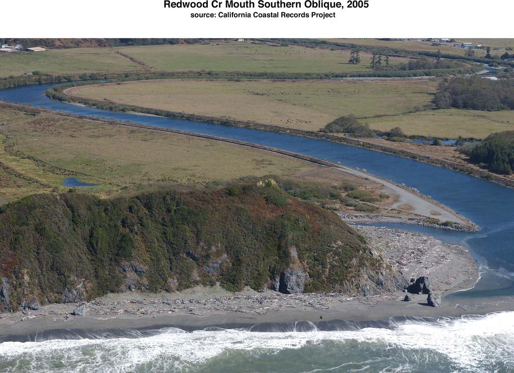
1 OBJECTIVES: GEOLOGY 435 FIELD EXERCISE 2, SPRING SKETCHING, DESCRIBING, AND MAPPING EXPOSURES To develop and refine your field skills in: 1. observation and rock and sediment description 2. sketching and describing outcrops 3. locating yourself and in measuring attitudes, fold axes, and lineations 4. simple geologic mapping LOCATION: The field area encompasses coastal bluffs between the mouth of Redwood Creek and the rocky point approximately 1500 ft north of the mouth - see attached topographic map and oblique air photos. The area is part of Redwood National and State Parks; please do not use rock hammers or collect samples. Although the beach is wide, you should be aware of the waves and tide. We will be starting out at a rising tide (-0.8 ft). High tide Sat. Apr. 9 is just about 2:00 PM (~ 6.3 ft) EQUIPMENT NEEDED: Brunton compass Hand lens Colored pencils, 2H or 3h pencils, eraser, sharpener MATERIALS ACCOMPANYING EXERCISE: Oblique 2005 color airphotos of mapping area (2) Topographic map, 1:2400 scale, created from LiDAR image by Nick Graehl, modified by Andre Lehre Composite airphoto and map 1:2400 scale BACKGROUND: Bedrock exposed in the bluffs north of the mouth of Redwood Creek is Redwood Creek schist. This unit, correlative with the South Fork Mountain schist, is part of the Franciscan Assemblage. The Redwood Creek schist is typically a light-green to dark grey phyllite or fine-grained schist consisting largely of quartz, chlorite, white mica, and albite (Harden et. al 82; Cashman et. al ( 86, 95). The schist is commonly metamorphosed mudstone and metagreywacke, but locally includes metabasalt and metamorphosed tuff. 1. Preliminary walk-through We will start by walking together through the study area so that you all become familiar with the rocks and structures. We ll start at the south end of the bluffs and walk north up the beach as a group. I ll point out particular exposures that merit careful study. When we reach the prominent outcrop at the north end of the mapping area, you can begin your descriptions and measurements, and work your way south toward the vehicles. We should all be back at the vehicles by 2:30 PM. 2. Field measurement of attitudes and mapping and description of the bedrock exposed along the beach north of the mouth of Redwood Creek. You will start where we end our walk up the beach. Work back down the beach toward the mouth, keeping track of your location on the oblique airphotos, composite map/photo and the topographic map. a. Measurement of bedrock attitudes: At the two exposures I indicate, and also wherever you find an exposure that reveals geologic structure: 1. Locate your position on the airphoto and map. Number your locations sequentially in the notebook beginning with 1 at the north. Mark your numbered positions on the oblique airphoto(s) and the vertical airphoto. 2. At each location examine the bedrock and measure any of the following you can recognize: Strike and dip of bedding and/or foliation Strike and dip of faults, jointing, cleavage, or planar veins filling joints Trend and plunge of lineations or fold axes 3. Record orientation measurements neatly in a table in your notebook. 4. Plot representative foliation and lineation measurements for each station on the topographic map at the correct locations, using the appropriate symbols from Compton (p )
2 b. Bedrock description and sketch at the two outcrops I indicate: 1. make a careful lithologic description of the bedrock. Descriptions should be clear, concise, and informative. Lithologic descriptions should include: overall color and appearance degree of weathering -- how hard is the rock, is it friable, what does it break down to if it's pretty weathered? particle/grain size texture (foliated, non-foliated ) mineralogy -- what minerals can you see in it, if any? any sedimentary features observable: grain size, rounding, sorting, stratification (well-laminated? massive?) type of rock -- give it a name! 2. describe of the outcrop and its structural features such that a person who has never seen the outcrop could read it and understand what you saw Outcrop descriptions should include (but are not limited to): attitude (strike & dip) of bedding and/or foliation how obvious is bedding? how strongly developed is foliation? is there more than one direction of foliation? how are foliation and bedding related (e.g. parallel, crossing at 90, or what?) is there any folding? how does it relate to foliation? is there more than one set of folding? what is the attitude (trend & plunge) of any fold axes how fractured is the rock? is it massive? are there any joints? are they closely or widely spaced (give dimensions)? is there more than one joint direction? what is the attitude of the joints? are there vein-fillings of joints? if so, what is their orientation (strike & dip)? are they folded or faulted? how continuous are they? 3. make a simple annotated/labeled geologic sketch of the outcrop showing the features you measured/observed c. Geologic outcrop map (on the topographic base map) -- to be made as you work your way down the beach: There are two geologic units that I want you to map: 1) outcrops of Redwood Creek schist (KJfr), and 2) cones of talus (Qtal). 1. Locating yourself: At each outcrop or feature to be mapped, carefully locate yourself by inspection of topography, and by using the oblique and composite airphotos. 2. Outcrop mapping: On your composite topographic map/photo, draw the boundaries of the schist outcrops in the bluffs and large blocks on the beach. You can use the vertical and oblique airphotos to help you. You can use pacing to help measure horizontal dimensions. Vertical extent will have to estimated either by eye, or by the combination of pacing a distance normal to the bluff and then taking a vertical angle with the Brunton. On your map lightly color these green. 2. Talus mapping: On the composite topographic map/photo, draw the boundaries of the cones of bare talus and slope debris. Lightly color these yellow. Do not map vegetated slopes as talus. 3. Landslide scarps: If you recognize any landslides, draw in the boundaries of their head and side scarps using the symbol below:
3 WHAT YOU WILL NEED TO TURN IN Due date: All materials are due no later than 5PM on Friday, April Field notes: A clear, readable photocopy of your field notes and sketches. This should be the original notes, not recopied ones. 2. Observation locations: Oblique airphoto(s) with station locations correctly shown and neatly numbered and keyed to notebook. 3. Field map: The map you prepared in the field on the topographic map base. 4. Geologic map: Transfer your data from the field map/photo to the office copy of the map. This geologic map should show: 1) all attitudes correctly plotted and inked at sites where they were measured; and 2) outcrop and talus boundaries neatly plotted and inked. Label schist outcrops KJfr and lightly color these green. Label the talus cones and slope debris Qtal and color them yellow. Show any lanslide scarps using the symbol above. Use Compton to be sure you are using correct symbols (i.e., for bedding, foliation, jointing, cleavage, lineations, fold axes) Note: use a very fine pen for inking. 5. Lithologic and outcrop descriptions For each one of the two outcrops, turn in a) a typed, clearly written lithologic description (see b1 above) and b) a clearly written outcrop description (see b2 above). These should be single-spaced and should be a maximum of 2 pages for each outcrop. (That is, no more than 4 pages for the whole works.) I expect that you will use good English and complete but concise sentences. 6. Evaluation sheet on last page of this lab REFERENCES Harden, D.R, H.M. Kelsey, S.D., Morrison, and T.A. Stephens, Geologic map of the Redwood Creek drainage basin, Humboldt County, California: US Geological Survey Water-Resources Investigations Open -File Report Cashman, S.M., Cashman, P.H., and Longshore, J.D., 1986, Deformation history and regional tectonic significance of the Redwood Creek schist, northwestern California: Geological Society of America Bulletin, v. 97, p Cashman, S.M., H.M. Kelsey, and D.R. Harden, Geology of the Redwood Creek Basin, Humboldt County, California: US Geological Survey Professional Paper 1454-B, p. B1-B13.
4 EVALUATION OF REDWOOD CR MOUTH MAPPING EXERCISE Name: Notebook: organization, neatness & readability (10) Points Notebook: completeness & relevant detail, descriptions (10) Airphotos: observation station locations: (10) Map: contact accuracy : (10) Map: detail & coverage: (10) Map: attitudes: (10) Map: presentation, neatness: (10) Rock unit and outcrop descriptions (30) Total

5
6

7

8
GEOLOGY 470 FIELD EXERCISE 3, SPRING SKETCHING, DESCRIBING, AND MAPPING EXPOSURES
 GEOLOGY 470 FIELD EXERCISE 3, SPRING 2009 -- SKETCHING, DESCRIBING, AND MAPPING EXPOSURES 1 OBJECTIVES: To develop and refine your field skills in: 1. observation and rock and sediment description 2. sketching
Structural Geology, GEOL 330 Fold mapping lab: Even folds get parasites Spring, 2012
 Structural Geology, GEOL 330 Name: Fold mapping lab: Even folds get parasites Spring, 2012 This exercise is meant to mimic a field experience in which you, the student, will measure beddingcleavage relationships
Field Exercise Handout ERTH 480 & 483
 Field Exercise Handout ERTH 480 & 483 General This handout is intended to provide you with some of the basic information that you will use in the next few weeks. The following pages contain suggestions
GEOL 02 Lab 9 Field Trip III Centerville Stratigraphic Section Name: Date:
 Name: Date: Team Name: Team Members: Our goal today is to describe the sedimentary lithostratigraphic section of exposed bedrock along the road near Centerville Beach, interpret the depositional environment,
Field Trip to Tempe Butte
 Synopsis Field Trip to Tempe Butte So far you have been identifying rocks and mapping their locations without actually going there. Now it is your chance to put it all together and see real rocks out in
UNIVERSITY OF NAIROBI COLLEGE OF EDUCATION AND EXTERNAL STUDIES & SCHOOL OF PHYSICAL SCIENCE DEPARTMENT OF GEOLOGY SGL 308:
 UNIVERSITY OF NAIROBI COLLEGE OF EDUCATION AND EXTERNAL STUDIES & SCHOOL OF PHYSICAL SCIENCE DEPARTMENT OF GEOLOGY SGL 308: INTRODUCTION TO GEOLOGICAL MAPPING WRITTEN BY Reviewed by: C.M. Nyamai, W.M.
Questions for the Edwards formation
 Name: Professor name: Class Time: The Virtual Field trip is to be completed by your self. You should not work with a partner. This is not group work. Nor should you search for answers on the internet.
We will provide: hammers (one per group), hard hats, shovels, paper bags or boxes for pebble collections, map boards, and compasses, measuring tapes.
, hard hats, shovels, paper bags or boxes for pebble collections, map boards, and compasses, measuring tapes.") Geology 110 Spring 1999 Northfield Topography and Field Trip to Little Chicago This lab has two parts. After the spot test on the geologic time scale, we will spend the next few hours at a gravel pit near
Geology 110 Spring 1999 Northfield Topography and Field Trip to Little Chicago This lab has two parts. After the spot test on the geologic time scale, we will spend the next few hours at a gravel pit near
Springshed Springshed Management Training Curriculum
 Springshed Springshed Management Training Curriculum Management Training Curriculum Draft Version 2 January 2016 The Springs Initiative 2016 The Springs Initiative SESSION TITLE: Section Mapping SECTION:
Part I. PRELAB SECTION To be completed before labs starts:
 Student Name: Physical Geology 101 Laboratory #13 Structural Geology II Drawing and Analyzing Folds and Faults Grade: Introduction & Purpose: Structural geology is the study of how geologic rock units
The University of Jordan. Accreditation & Quality Assurance Center. Course Name: Structural Geology COURSE Syllabus
 The University of Jordan Accreditation & Quality Assurance Center COURSE Syllabus Course Name: Structural Geology 0305341 1 Course title Structural Geology 2 Course number 0305341 3 Credit hours (theory,
GEOL 220A Geologic Field Experiences: West Virginia Spring Term, 2008
 GEOL 220A Geologic Field Experiences: West Virginia Spring Term, 2008 Dr. Fred Soster Office: 216 Julian S&M e-mail: fsoster@depauw.edu Phone: 658-4670 Meeting Times: 2:15-3:15 p.m., Monday & Wednesday;
 Figure 1. Regional map from Roure and Blanchet (1983), Blake et al. (1982, 1985a), and G. Harper and M. Giaramita (unpublished mapping). Mineral Hill and Saddle Mountain greenstone blocks are blocks in
FIELD GEOLOGY AND GEOLOGIC MAPPING TECHNIQUES Geology Fall Semester 2007 Dr. Randy L. Kath, P.G.
 FIELD GEOLOGY AND GEOLOGIC MAPPING TECHNIQUES Geology 3004-01 Fall Semester 2007 Dr. Randy L. Kath, P.G. rkath@westga.edu General Outline (subject to change) I. General Principles and Techniques 1) Philosophy
The Geology of Two Lights State Park. Cape Elizabeth, Maine
 Maine Geologic Facts and Localities June, 2002 Cape Elizabeth, Maine 43 33 33.48 N, 70 12 13.32 W Text by Henry N. Berry IV and Robert G. Marvinney, Department of Agriculture, Conservation & Forestry 1
LAB 5: LANDSLIDE RECOGNITION AND MAPPING
 Geology 350 1 LAB 5: LANDSLIDE RECOGNITION AND MAPPING OBJECTIVES: a. to learn to recognize and classify landslides on airphotos and topographic maps b. to learn to recognize landslide topography on topographic
Part 1: Observations for the Edwards Formation
 Name: Spring 2018 Professor name: Class Time: The Virtual Field trip is to be completed by your self. You should not work with a partner. This is not group work. Nor should you search for answers on the
Structural Geology and Geology Maps Lab
 Structural Geology and Geology Maps Lab Mesa College Geology 101 Lab Ray Rector: Instructor Structural Geology Lab Pre-Lab Resources Pre-Lab Internet Links 1) Fundamentals of Structural Geology 2) Visualizing
Name. GEOL.5220 Structural Geology Faults, Folds, Outcrop Patterns and Geologic Maps. I. Properties of Earth Materials
 I. Properties of Earth Materials GEOL.5220 Structural Geology Faults, Folds, Outcrop Patterns and Geologic Maps Name When rocks are subjected to differential stress the resulting build-up in strain can
=%REPORT RECONNAISSANCE OF CHISHOLM LAKE PROSPECT. October 25, 1977
 =%REPORT ON FIELD RECONNAISSANCE OF CHISHOLM LAKE PROSPECT October 25, 1977 Bruce D. Vincent Imperial Oil Limited, Minerals - Coal, CALGARY, ALBERTA CHISHOLM LAKE PROSPECT Introduction The Chisholm Lake
Chapter 15 Structures
 Chapter 15 Structures Plummer/McGeary/Carlson (c) The McGraw-Hill Companies, Inc. TECTONIC FORCES AT WORK Stress & Strain Stress Strain Compressive stress Shortening strain Tensional stress stretching
Geology 101 Lab Worksheet: Geologic Structures
 Name: Geology 101 Lab Worksheet: Geologic Structures Refer to the Geologic Structures Lab for the information you need to complete this worksheet (http://commons.wvc.edu/rdawes/g101ocl/labs/structurelab.html).
Stress and Strain. Stress is a force per unit area. Strain is a change in size or shape in response to stress
 Geologic Structures Geologic structures are dynamically-produced patterns or arrangements of rock or sediment that result from, and give information about, forces within the Earth Produced as rocks change
Staple this part to part one of lab 6 and turn in. Lab 6, part two: Structural geology (analysis)
") Geology 101 Staple this part to part one of lab 6 and turn in Lab 6, part two: Structural geology (analysis) Recall that the objective of this lab is to describe the geologic structures of Cougar Mountain
Geology 101 Staple this part to part one of lab 6 and turn in Lab 6, part two: Structural geology (analysis) Recall that the objective of this lab is to describe the geologic structures of Cougar Mountain
LAB 6: TRINIDAD BEACH FIELD TRIP
 OBJECTIVES: LAB 6: TRINIDAD BEACH FIELD TRIP 1) to develop your powers of observation, especially of geological phenomena; 2) to identify the rocks exposed at Trinidad Beach; 3) to reconstruct some of
A.M. TUESDAY, 12 May hours
 Candidate Name Centre Number 2 Candidate Number GCE AS/A level 1212/01 New AS GEOLOGY - GL2a Investigative Geology A.M. TUESDAY, 12 May 2009 1 1 2 hours For Examiner s Use Only ADDITIONAL MATERIALS In
LAB 1: ORIENTATION OF LINES AND PLANES
 LAB 1: ORIENTATION OF LINES AND PLANES Read the introductory section, chapter 1, pages 1-3, of the manual by Rowland et al (2007) and make sure you understand the concepts of bearing, strike, dip, trend,
depression above scarp scarp
 1 LAB 1: FIELD TRIP TO McKINLEYVILLE AND MOUTH OF THE MAD RIVER OBJECTIVES: a. to look at geomorphic and geologic evidence for large scale thrust-faulting of young sediments in the Humboldt Bay region
 27 Figure 7 Poorly cleaved, massive, light-weathering Bomoseen graywacke outcrop located on Brandon Mountain Road. Figure 8 Photomicrograph of Bomoseen graywacke. Subangular, poorly sorted quartz grains
Structural Geology and Tectonics EPS116
 Structural Geology and Tectonics Field Trip and Lab Exercise #7: The San Gregorio fault zone near Half Moon Bay (Pillar Point, Moss Beach and Montara Beach) What to do before the field trip: You will need
Geologic Mapping Regional Tournament Trial Event
 Geologic Mapping Regional Tournament Trial Event A TEAM OF UP TO: 2 Team Name AVAILABLE TIME: 50 min Required Materials: Each team MUST have a protractor, ruler, non-programmable calculator, colored pencils,
Stratigraphy and structure of the Ganson Hill area: northern Taconic Allochthon
 University at Albany, State University of New York Scholars Archive Geology Theses and Dissertations Atmospheric and Environmental Sciences 1985 Stratigraphy and structure of the Ganson Hill area: northern
GEOL 02: Historical Geology Lab 14: Topographic Maps. Name: Date:
 GEOL 02: Historical Geology Lab 14: Topographic Maps Name: Date: A topographic map is a two dimensional (flat) representation (model) of a three dimensional land surface (landscape). It shows landforms
A. Refer to Appendix F in back of lab manual for list of commonly used geologic map symbols
 Structural Geology Lab 2: Outcrop Patterns and Structure Contours I. Geologic Map Symbols A. Refer to Appendix F in back of lab manual for list of commonly used geologic map symbols 1. Emphasis: a. strike
Chapter 8 Lecture. Earth: An Introduction to Physical Geology. Twelfth Edition. Metamorphism. Rocks. Tarbuck and Lutgens Pearson Education, Inc.
 Chapter 8 Lecture Earth: An Introduction to Physical Geology Twelfth Edition Metamorphism and dmetamorphic Rocks Tarbuck and Lutgens Chapter 8 Metamorphic Rocks What Is Metamorphism? Metamorphism means
Structural Geology Lab. The Objectives are to gain experience
 Geology 2 Structural Geology Lab The Objectives are to gain experience 1. Drawing cross sections from information given on geologic maps. 2. Recognizing folds and naming their parts on stereoscopic air
Lab 6: Plate tectonics, structural geology and geologic maps
 Geology 103 Name(s): Lab 6: Plate tectonics, structural geology and geologic maps Objective: To show the effects of plate tectonics on a large-scale set of rocks and to reconstruct the geological history
CHAPTER 3.3: METAMORPHIC ROCKS
 CHAPTER 3.3: METAMORPHIC ROCKS Introduction Metamorphism - the process of changes in texture and mineralogy of pre-existing rock due to changes in temperature and/or pressure. Metamorphic means change
Structural Geology Lab. The Objectives are to gain experience
 Geology 2 Structural Geology Lab The Objectives are to gain experience 1. Drawing cross sections from information given on geologic maps. 2. Recognizing folds and naming their parts on stereoscopic air
GEOL 3700 STRUCTURE AND TECTONICS LABORATORY EXERCISE 3
 GEOL 3700 STRUCTURE AND TECTONICS LABORATORY EXERCISE 3 Goals: 1. Improve your map-reading and map-making skills. 2. Learn to generate and interpret structure contour maps. 3. Learn to generate and interpret
Answer sheet for question 1 Answer question 1 as soon as the sample arrives at your desk.
 EAS 233 Geologic structures. Final test. April 2012. 3 hours. Answer question 1 and 2 and three other questions. If you start more than the required number of questions, clearly delete the answers you
GG303 Lecture 29 9/4/01 1 FABRICS
 GG303 Lecture 29 9/4/01 1 FABRICS I Main Topics A What are fabrics? B Planar fabrics C Linear fabrics D Penetrative vs. non-penetrative fabrics E Cleavage and folds F Comments on use of grain-scale observations
Crustal Deformation Earth - Chapter Pearson Education, Inc.
 Crustal Deformation Earth - Chapter 10 Structural Geology Structural geologists study the architecture and processes responsible for deformation of Earth s crust. A working knowledge of rock structures
2) Question: Very briefly describe the differences between these two types of metamorphism:
 Question: Very briefly describe the differences between these two types of metamorphism:") Name: Grade: GEOL 101 - Physical Geology Laboratory METAMORPHIC ROCKS PRELAB & LAB WORKSHEETS PRELAB SECTION To be completed before labs starts: I. Introduction & Purpose: The purpose of this laboratory
Name: Grade: GEOL 101 - Physical Geology Laboratory METAMORPHIC ROCKS PRELAB & LAB WORKSHEETS PRELAB SECTION To be completed before labs starts: I. Introduction & Purpose: The purpose of this laboratory
Lab Activity on Sedimentary and Metamorphic Rocks
 Lab Activity on Sedimentary and Metamorphic Rocks 2002 Ann Bykerk-Kauffman, Dept. of Geological and Environmental Sciences, California State University, Chico * Objectives When you have completed this
Metamorphism and Metamorphic Rocks Earth - Chapter Pearson Education, Inc.
 Metamorphism and Metamorphic Rocks Earth - Chapter 8 Metamorphism Transition of one rock into another by temperatures and/or pressures unlike those in which it formed Metamorphic rocks are produced from:
Big Island Field Trip
 Big Island Field Trip Space Still Available Group Airline Tickets May be available if enough people sign on If interested send email to Greg Ravizza Planning Meeting Next Week Will
The Geology of the Marginal Way, Ogunquit, Maine
 Maine Geologic Facts and Localities February, 2002 The Geology of the Marginal Way, Ogunquit, Maine 43 14 23.88 N, 70 35 18.36 W Text by Arthur M. Hussey II, Bowdoin College and Robert G. Marvinney,, Department
Answers: Internal Processes and Structures (Isostasy)
") Answers: Internal Processes and Structures (Isostasy) 1. Analyse the adjustment of the crust to changes in loads associated with volcanism, mountain building, erosion, and glaciation by using the concept
Answers: Internal Processes and Structures (Isostasy) 1. Analyse the adjustment of the crust to changes in loads associated with volcanism, mountain building, erosion, and glaciation by using the concept
Hand specimen descriptions of metamorphic rocks
 Hand specimen descriptions of metamorphic rocks Hand specimen descriptions for metamorphic rocks are like those for igneous rocks. The objective is to tell someone looking at it everything they need to
Deformation of Rocks. Orientation of Deformed Rocks
 Deformation of Rocks Folds and faults are geologic structures caused by deformation. Structural geology is the study of the deformation of rocks and its effects. Fig. 7.1 Orientation of Deformed Rocks
454/01 GEOLOGY GL4 INTERPRETING THE GEOLOGICAL RECORD. A.M. MONDAY, 12 June (2 Hours)
") Candidate Name Centre Number Candidate Number WELSH JOINT EDUCATION COMMITTEE General Certificate of Education Advanced CYD-BWYLLGOR ADDYSG CYMRU Tystysgrif Addysg Gyffredinol Uwch 454/01 GEOLOGY GL4 INTERPRETING
Candidate Name Centre Number Candidate Number WELSH JOINT EDUCATION COMMITTEE General Certificate of Education Advanced CYD-BWYLLGOR ADDYSG CYMRU Tystysgrif Addysg Gyffredinol Uwch 454/01 GEOLOGY GL4 INTERPRETING
Engineering Geology. Metamorphic Rocks. Hussien Al - deeky
 Metamorphic Rocks Hussien Al - deeky 1 Definition Metamorphic rock is the result of the transformation of an existing rock type, the protolith (parent rock), in a process called metamorphism, which means
Crustal Deformation. (Building Earth s Surface, Part 1) Science 330 Summer Mapping geologic structures
 Science 330 Summer Mapping geologic structures") Crustal Deformation (Building Earth s Surface, Part 1) Science 330 Summer 2005 Mapping geologic structures When conducting a study of a region, a geologist identifies and describes the dominant rock structures
Crustal Deformation (Building Earth s Surface, Part 1) Science 330 Summer 2005 Mapping geologic structures When conducting a study of a region, a geologist identifies and describes the dominant rock structures
GEOL Lab 11 (Metamorphic Rocks in Hand Sample and Thin Section)
") GEOL 333 - Lab 11 (Metamorphic Rocks in Hand Sample and Thin Section) Introduction - Metamorphic rock forms from any pre-existing rock that undergoes changes due to intense heat and pressure without melting.
GEOL 333 - Lab 11 (Metamorphic Rocks in Hand Sample and Thin Section) Introduction - Metamorphic rock forms from any pre-existing rock that undergoes changes due to intense heat and pressure without melting.
GEO 103. OBJECTIVES Familiarity with general facts, principles and concepts of Earth and Earth Processes
 GEO 3 Familiarity with general facts, principles and concepts of Earth and Earth Processes 1 2 5 6 7 8 Identify Earth materials and use simple geological tools Become familiar with geologic data, as displayed
GY 402 Sedimentary Petrology (2016) Mature Siliciclastic Sedimentary Rock Thin-sections
 Mature Siliciclastic Sedimentary Rock Thin-sections") Thin Section 1 GY 402 Sedimentary Petrology (2016) Mature Siliciclastic Sedimentary Rock Thin-sections Quartz arenite sandstones in thin section (field of view for each approximately 2 mm). From Williams,
Thin Section 1 GY 402 Sedimentary Petrology (2016) Mature Siliciclastic Sedimentary Rock Thin-sections Quartz arenite sandstones in thin section (field of view for each approximately 2 mm). From Williams,
MEMO. TO: Dennis Lapoint CC: FROM: Eriaan Wirosono DATE: April, 20 th 2014 SUBJECT: Exploration activity report March-April 2014_EW
 TO: Dennis Lapoint CC: FROM: Eriaan Wirosono DATE: April, 20 th 2014 SUBJECT: Exploration activity report March-April 2014_EW MEMO 1. Highlights and Productivity Overview pan sampling on target Areas 1
Structural Geology Laboratory.
 Structural Geology Wikipedia-Structural geology is the study of the threedimensional distribution of rock units with respect to their deformational histories. The primary goal of structural geology is
Stratigraphic Cross-Section
 Stratigraphic cross-sections are used to show stratigraphic relationships of strata along some path. They differ from structural cross-sections in three ways. First, their goals differ. Stratigraphic cross-sections
Section 5. Rock Units and Your Community. What Do You See? Think About It. Investigate. Learning Outcomes
 Chapter 3 Minerals, Rocks, and Structures Section 5 Rock Units and Your Community What Do You See? Learning Outcomes In this section, you will Recognize that rocks are arranged in Earth s crust as well-defined
A Geological Tour of Tumbledown Mountain, Maine
 Maine Geologic Facts and Localities April, 1998 A Geological Tour of Tumbledown Mountain, Maine 44 45 3.21 N, 70 32 50.24 W Text by Robert G. Marvinney, Department of Agriculture, Conservation & Forestry
GLG598 Surface Processes and Landform Evolution K. Whipple Fall 2012 VERDE RIVER: FLOW MECHANICS, ROUGHNESS, AND SHEAR STRESS
 VERDE RIVER: FLOW MECHANICS, ROUGHNESS, AND SHEAR STRESS This lab will introduce you to some common field techniques and some general understanding of the geomorphic processes operating in a stream. The
Metamorphism: summary in haiku form
 Metamorphism & Metamorphic Rocks Earth, Chapter 8 Metamorphism: summary in haiku form Shape-shifters in crust. Just add heat and/or pressure. Keep it solid please! What Is Metamorphism? Metamorphism means
Lab 7: STRUCTURAL GEOLOGY FOLDS AND FAULTS
 Lab 7: STRUCTURAL GEOLOGY FOLDS AND FAULTS This set of labs will focus on the structures that result from deformation in earth s crust, namely folds and faults. By the end of these labs you should be able
MAPS AND CROSS SECTIONS (I)
") GG303 Lab 3 8/27/09 1 MAPS AND CROSS SECTIONS (I) I Main Topics A Three point problems B Rule of vees C Map interpretation and cross sections II Three point problems (see handout) A Three points define
GG303 Lab 3 8/27/09 1 MAPS AND CROSS SECTIONS (I) I Main Topics A Three point problems B Rule of vees C Map interpretation and cross sections II Three point problems (see handout) A Three points define
Lecture Outline Friday March 2 thru Wednesday March 7, 2018
 Lecture Outline Friday March 2 thru Wednesday March 7, 2018 Questions? Lecture Exam Friday March 9, 2018 Same time, Same room Bring Pencils and WSU ID 50 question Multiple Choice, Computer Graded Interlude
Engineering Geology ECIV 3302
 Engineering Geology ECIV 3302 Instructor : Dr. Jehad Hamad 2019-2018 Chapter (7) Metamorphic Rocks Chapter 7 Metamorphism and Metamorphic Rocks Metamorphism The transition of one rock into another by temperatures
Do Now (2 minutes) 3/19. K What I know about Metamorphic Rocks. W What I want to find out about Metamorphic Rocks
 3/19. K What I know about Metamorphic Rocks. W What I want to find out about Metamorphic Rocks") Do Now (2 minutes) K What I know about Metamorphic Rocks 3/19 W What I want to find out about Metamorphic Rocks 1. 2. 3. 1. 2. 3. What are metamorphic rocks and how do we classify them? Metamorphic Rocks
Do Now (2 minutes) K What I know about Metamorphic Rocks 3/19 W What I want to find out about Metamorphic Rocks 1. 2. 3. 1. 2. 3. What are metamorphic rocks and how do we classify them? Metamorphic Rocks
Marshall Shore Town Park, Liberty, Maine
 Maine Geologic Facts and Localities August, 2005 Marshall Shore Town Park, Liberty, Maine 44 22 33.04 N, 69 21 9.19 W Text by Henry N. Berry IV, Department of Agriculture, Conservation & Forestry 1 Introduction
PLANE AND ATTITUDE OF STRATA
 2307216 Field Methods in Geology I PLANE AND ATTITUDE OF STRATA ผ ช วยศาสตราจารย ดร.ว ช ย จ ฑะโกส ทธ กานนท ภาคว ชาธรณ ว ทยา คณะว ทยาศาสตร จ ฬาลงกรณ มหาว ทยาล ย vichaic@yahoo.com Outline Basic knowledge
Lesson Seven: Metamorphic Rocks
 Name: Date: GEOL1 Physical Geology Laboratory Manual College of the Redwoods Lesson Seven: Metamorphic Rocks Background Reading: Metamorphic Rocks Metamorphic Rocks These are rocks that have been changed
CHAPTER 6, PRELIMINARY SITE INVESTIGATION CONTENTS
 CHAPTER 6, PRELIMINARY SITE INVESTIGATION CONTENTS - Page Purpose... 6-1 Assembly of data... 6-1 Use of aerial photographs... 6-2 Field study... 6-3 Mappix... 6-4 Repcrt of preliminary investigation...
Structural Geology, GEOL 330 Spring 2012
 Developing the Magic Eye for folds This lab exercise is designed to get you thinking about the chronology of structural processes and and the resultant map patterns in areas with flat topography. You may
ANKARA UNIVERSITY DEPARTMENT of GEOLOGICAL ENGINEERING GEO402 GEOLOGICAL MAPPING SAFETY IN THE FIELD FIELD MEASUREMENTS AND TECHNIQUES
 ANKARA UNIVERSITY DEPARTMENT of GEOLOGICAL ENGINEERING GEO402 GEOLOGICAL MAPPING SAFETY IN THE FIELD FIELD MEASUREMENTS AND TECHNIQUES Dr. Koray ULAMIŞ 2017 Potential Hazards and Safety Measures Falling
ESC 1000 (Neuhoff) Assignment #2: Rocks and Tectonics
 Assignment #2: Rocks and Tectonics") 1 ESC 1000 (Neuhoff) Assignment #2: Rocks and Tectonics Name: UF ID: Assignment is due by the beginning of class on Wednesday, October 13. This assignment is worth 45 points towards your final grade. Please
1 ESC 1000 (Neuhoff) Assignment #2: Rocks and Tectonics Name: UF ID: Assignment is due by the beginning of class on Wednesday, October 13. This assignment is worth 45 points towards your final grade. Please
Downloaded from Downloaded from
 IV SEMESTER BACK-PAPER EXAMINATION-2004 Q. [1] [a] Describe internal structure of the earth with a neat sketch. Write down the major land forms and their characteristics on the earth surface. [8] [b] What
ENGINEERING EVALUATION OF THE STANLEY MINE ADVENTURE PARK AREA CLEAR CREEK COUNTY, COLORADO. Prepared for:
 braun Braun Consulting Engineers ENGINEERING EVALUATION OF THE STANLEY MINE ADVENTURE PARK AREA CLEAR CREEK COUNTY, COLORADO Prepared for: STANLEY MINES ADENTURE PARK 3375 W. POWERS CIRCLE LITTLETON, COLORADO
In this lab, we will study and analyze geologic maps from a few regions, including the Grand Canyon, western Wyoming, and coastal California.
 Name: Lab Section: work in groups, but each person turns in his/her own GEOSCIENCE 001 LAB UNDERSTANDING GEOLOGIC MAPS Geologic maps are colorful and even beautiful, but they also contain an amazing amount
Structural Geology (GE 231) Syllabus Fall, 2007
 Syllabus Fall, 2007") 1. Instructor Walter A. Sullivan (Bill) Office: Mudd 215 Office hours: Open-door policy Office phone: 859-5803 E-mail: wasulliv@colby.edu 2. Texts and required materials Structural Geology (GE 231) Syllabus
1. Instructor Walter A. Sullivan (Bill) Office: Mudd 215 Office hours: Open-door policy Office phone: 859-5803 E-mail: wasulliv@colby.edu 2. Texts and required materials Structural Geology (GE 231) Syllabus
Lecture 5 Sedimentary rocks Recap+ continued. and Metamorphic rocks!
 Lecture 5 Sedimentary rocks Recap+ continued and Metamorphic rocks! Metamorphism Process that leads to changes in: Mineralogy Texture Sometimes chemical composition Metamorphic rocks are produced from
LAB - Rock Classification
 NAME: LAB - Rock Classification Date: Introduction: A rock is any naturally occurring aggregate of minerals, mineral-like solids, glass, or organic particles. The properties that can be observed in a rock
Geological mapwork from scratch 2: valley with simple geology Draw your own cross sections and 3D geological model
 Geological mapwork scratch 2: valley with simple geology Draw your own cross sections and 3D geological model A valley with a stream looks like this: Modified the Geograph project collection. Copyright
Name: KEY. Examine all possible answers; some may not satisfy the question criteria and should be left blank. mica crystals big enough to see
 GE 50 Exam #3, FS07 Name: KEY_ Examine all possible answers; some may not satisfy the question criteria and should be left blank. 1. Match the metamorphic rock with its foliated texture. [10 pts] slate
Metamorphism & Metamorphic Rocks
 1 2 3 4 5 6 7 8 9 10 11 & Metamorphic Rocks Earth 9 th edition, Chapter 8 Mass wasting: summary in haiku form Shape-shifters in crust. Just add heat and/or pressure. Keep it solid please! Key Concepts
GG303 Lab 5 10/4/17 1
 GG303 Lab 5 10/4/17 1 Lab 5 Spherical Projections Use a separate piece of paper for each exercise, and include printouts of your Matlab work. 103 pts for Ex. 1-4; 124 points for Ex. 1-5. Exercise 1: Plots
EPS 50 Lab 6: Maps Topography, geologic structures and relative age determinations
 Name: EPS 50 Lab 6: Maps Topography, geologic structures and relative age determinations Introduction: Maps are some of the most interesting and informative printed documents available. We are familiar
NAME HOMEWORK ASSIGNMENT #3 MATERIAL COVERS CHAPTERS 8, 9, 10, 11
 NAME HOMEWORK ASSIGNMENT #3 MATERIAL OVERS HAPTERS 8, 9, 10, 11 Assignment is due the beginning of the class period on November 23, 2004. Answers for each chapter will be discussed in class, as Exam #3
Falmouth Town Landing, Falmouth, Maine
 Maine Geologic Facts and Localities April, 2018 Falmouth Town Landing, Falmouth, Maine 43 o 43 57.2 N, 70 o 12 16.7 W Text by Ian Hillenbrand, Department of Agriculture, Conservation & Forestry 1 Photo
NOA ASSESSMENT HARRIS QUARRY MENDOCINO COUNTY, CALIFORNIA TABLE OF CONTENTS
 NOA ASSESSMENT HARRIS QUARRY MENDOCINO COUNTY, CALIFORNIA TABLE OF CONTENTS Introduction... 1 Scope of Services... 1 Project Location and Description... 1 Geologic Setting... 1 Regional Geology... 1 Site
Some Geological Features at Smalls Falls, Maine
 Maine Geologic Facts and Localities July, 2005 Some Geological Features at Smalls Falls, Maine 44 51 30.47 N, 70 30 58.74 W Text by Robert Marvinney, Department of Agriculture, Conservation & Forestry
OCEAN/ESS 410. Lab 8. Igneous rocks
 Lab 8. Igneous rocks Today s exercise is an introduction to rock identification and the crustal structure of the seafloor. All rocks are composed of two or more minerals, and can be classified based on
As compaction and cementation of these sediments eventually occur, which area will become siltstone? A) A B) B C) C D) D
 A B) B C) C D) D") 1. A student obtains a cup of quartz sand from a beach. A saltwater solution is poured into the sand and allowed to evaporate. The mineral residue from the saltwater solution cements the sand grains together,
1. A student obtains a cup of quartz sand from a beach. A saltwater solution is poured into the sand and allowed to evaporate. The mineral residue from the saltwater solution cements the sand grains together,
GEL 109 Midterm W05, Page points total (1 point per minute is a good pace, but it is good to have time to recheck your answers!
 GEL 109 Midterm W05, Page 1 50 points total (1 point per minute is a good pace, but it is good to have time to recheck your answers!) 1. Are the following flow types typically laminar or turbulent and
Team Name. Name(s) SSSS Unome Geologic Mapping Test Packet p1
 SSSS Unome Geologic Mapping Test Packet p1") Scioly Summer Study Session 2018-2019 Geologic Mapping Test Packet Written by Unome Instructions 1) This test is based on the 2016 rules for Geologic Mapping. 2) This test is out of 115 points. Questions
Scioly Summer Study Session 2018-2019 Geologic Mapping Test Packet Written by Unome Instructions 1) This test is based on the 2016 rules for Geologic Mapping. 2) This test is out of 115 points. Questions
B) color B) Sediment must be compacted and cemented before it can change to sedimentary rock. D) igneous, metamorphic, and sedimentary rocks
 color B) Sediment must be compacted and cemented before it can change to sedimentary rock. D) igneous, metamorphic, and sedimentary rocks") 1. Which characteristic of nonsedimentary rocks would provide the least evidence about the environment in which the rocks were formed? A) structure B) color C) crystal size D) mineral composition 2. Which
1. Which characteristic of nonsedimentary rocks would provide the least evidence about the environment in which the rocks were formed? A) structure B) color C) crystal size D) mineral composition 2. Which
Objectives of this Lab. Introduction. The Petrographic Microscope
 Geological Sciences 101 Lab #9 Introduction to Petrology Objectives of this Lab 1. Understand how the minerals and textures of rocks reflect the processes by which they were formed. 2. Understand how rocks
Neotectonic Implications between Kaotai and Peinanshan
 Neotectonic Implications between Kaotai and Peinanshan Abstract Longitudinal Valley was the suture zone between the Philippine Sea plate and the Eurasia plate. Peinanshan was the southest segment of the
Geology Stratigraphic Correlations (Lab #4, Winter 2010)
") Name: Answers Reg. lab day: Tu W Th Geology 1023 Stratigraphic Correlations (Lab #4, Winter 2010) Introduction Stratigraphic correlation is the process of comparing rocks at one locality with related rocks
Name: Answers Reg. lab day: Tu W Th Geology 1023 Stratigraphic Correlations (Lab #4, Winter 2010) Introduction Stratigraphic correlation is the process of comparing rocks at one locality with related rocks
NAME: GEL 109 Final Winter 2010
 GEL 109 Final Winter 2010 1. The following stratigraphic sections represents a single event followed by the slow accumulation of background sedimentation of shale. Describe the flows that produced the