GEOL 02 Lab 9 Field Trip III Centerville Stratigraphic Section Name: Date:
|
|
|
- Barnaby Clifton Chase
- 5 years ago
- Views:
Transcription
1 Name: Date: Team Name: Team Members: Our goal today is to describe the sedimentary lithostratigraphic section of exposed bedrock along the road near Centerville Beach, interpret the depositional environment, and use this interpretation to fit the mapped lithostratigraphic units into the published regional geologic context. When taking notes of our observations, we want to take the notes in the same order each time, as usual. We will work as a two groups. We will learn: How to construct a stratigraphic column How to measure sedimentologic and geologic unit thickness How to interpret geologic observations within a regional geologic context We will first measure and describe the sediment stratigraphic section along the road near Centerville Beach, CA. Our note books will be arranged in a similar manner as for the Mad River Slough lab, with a stratigraphic column on the left and the description on the right. We will break the stratigraphic section into a small number of geologic units (3 5) based upon the big picture (be a lumper today). Then, describe the sedimentological variation of sedimentologic sub units within each major geologic unit. Along with describing the rocks, we will measure the thickness of the different sedimentary units. The geologic units that we are mapping are part of the Miocene to Pleistocene Wildcat formation and the Quaternary Hookton formation (Ogle, 1953). Ogle (1953) is posted on the lab website. At the end of this handout is a two page summary of the Wildcat and Hookton formations from Aalto (2006 and references therein), published in the 2006 Pacific Cell Friends of the Pleistocene Field Trip Guidebook. Part I. Geologic Description We will use our field notebooks to take notes about the sediments. We will interpret different sedimentary units, what are included in each sedimentary unit, and the boundaries between these units. For each sedimentary unit, we will describe the following: color, texture, structure, and notes. For each contact, we will note the depth and sharpness of the contact. We will also want to make a sketch of our field site (i.e. make a sketch of the road outcrop; include the location of where you collected strike and dip data). 1 P age

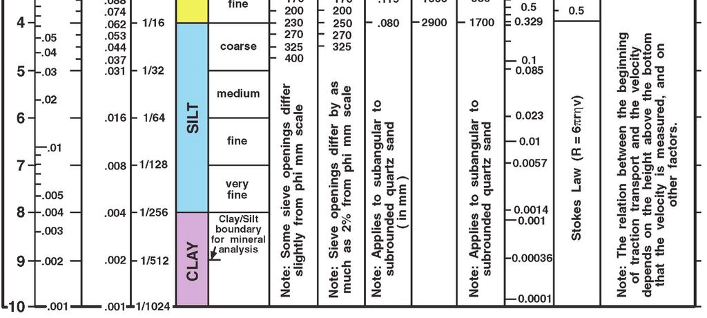
2 Part II. Stratigraphic Section Measurement The goal of measuring a stratigraphic column is to accurately characterize the thickness of different rock types. These data can be used to interpret depositional environments, variations in sediment type, and changes in sedimentation rate in space and time, etc. Most detailed interpretations require an accurate measure of how much of each rock type is present, bed thicknesses, etc. It is easy to measure the thickness of flat lying beds; you can put a ruler next to them and measure from bottom to top. For beds that have been tilted or folded, more care is needed. Measurements need to be made perpendicular to the bedding. Otherwise, results will depend on the amount of folding and the direction you are looking rather than the depositional processes that formed the rock. Geologists often use a Jacob s Staff to measure bedding thicknesses. A Jacob s Staff is a pole that is marked off in suitable units, such as decimeters. A Brunton is used as a clinometer to measure the angle of the pole from vertical and helps align the Jacob s Staff perpendicular to bedding for accurate measurements. To measure bed thickness, place the Jacob s Staff on the bedding plane at the base of the beds you want to measure. Next align the staff at right angles to bedding and sight downdip, perpendicular to strike, to the beds. The distance from the base of the staff to the sight point on the Brunton is equal to the thickness of strata between the base of the staff and the point sighted. There are a number of steps for doing this measurement accurately: Figure 1. A. Holding a Brunton compass against the Jacob staff in sighting position. B. Measuring the stratigraphic thickness between two bedding surfaces with a Jacob staff and clinometer (here, a Brunton; Figure from Compton, 1985; p. 230). 2 P age
3 1. Measure the strike and dip of bedding where you intend to measure the section; record the data and set the clinometer on the Brunton to the angle of dip. This could be recorded on your outcrop sketch. 2. Place the staff at the base of the unit to be measured and tilt it downdip (exactly perpendicular to strike) until the clinometer bubble in the Brunton is centered. 3. Study the point sighted on the ground and decide if the staff can be placed on it for your next measurement; if so, note the point carefully by eye or place an object at that point. You have measured an amount of stratigraphic section based upon where you placed the Brunton on the Jacob s staff. 5. If the base of the Jacob s Staff cannot be placed on the point you sighted for your next measurement, move the base of the staff along the lower bedding surface until a suitable point can be sighted. 6. Draw your stratigraphic column, describing the rocks in this unit. Measure the positions of beds within this stratigraphic interval using the Jacob s Staff. 7. Move the base of the Jacob s Staff to the sited point, and make your next measurement. Proceed similarly to the top of the unit. Using a Jacob s Staff and Brunton requires sighting through a small hole, and it may be tempting to save time by estimating the alignment of the staff rather than using the clinometer. Moderate errors in alignment, however, can cause large errors in measurements (Figure 2). In addition, when sighting up or down a slope, one tends to tilt the staff so that it is perpendicular to the ground surface. This gives errors that tend to accumulate through a series of measurements, giving a systematic over or under estimate of the true stratigraphic thickness. When the staff is correctly oriented with the clinometer, the error should be no more than a few centimeters per measure and will tend to average out in successive Figure 2: Errors in measurement (Figure from Compton, 1985; p. 231). 3 P age
.")
4 measurements. Thus, it is worth learning to measure accurately now; sighting becomes easier with practice. Sighting with a Jacob s Staff becomes increasingly awkward as dips become steeper. Lines of sight typically become shorter, however, so accuracy is maintained (Figure 3A). For dips greater than 70, the geologist can kneel and look along strike, viewing the clinometer face on and making the projection to the ground by estimation (Figure 3B). If some beds stick up significantly higher than others, it may be necessary to measure the thicknesses of the low lying beds and weathering resistant beds separately, using modified techniques. One can place the Brunton anywhere along the staff to measure an arbitrary thickness. Be careful to accurately record the thickness represented by each measurement, especially if they are different for each measurement. Figure 3: Jacob s Staff orientations depend on the relative dip of bedding and slope (Figure from Compton, 1985; p. 231). Figure 4. Sighting along strike with a Jacob staff. A. Holding the Brunton compass against the staff and sighting along edge of lid. B. Position for taking a measure. 4 P age
5 Steep walls of valleys eroded across strike often have the best exposures, and they must be measured by views parallel to strike. In such cases, the clinometer is set to the dip as usual but the lid of the compass is opened so as to make an angle of goo with the compass face (Figure 4A). The observer holds the compass against the staff and stands facing the compass and outcrop, looking exactly along strike (Figure 4B). The outcrop is sighted along the upper edge of the lid, and the staff is held so that the side facing the observer is vertical. Part III. Report We will want to communicate what we mapped today and place our observations within local geologic context (ogle, 1953; Aalto, 2006). Prepare a report that includes the standard sections (intro, methods, results, discussion, and conclusion). This report is due two weeks from the day that we collect these data. In your report, describe how we mapped the geologic units (descriptions in our field notebooks), measured stratigraphic section (Jacob s Staff), and which geologic units mapped by Ogle (1953) are probably the geologic units that we investigated for this lab. We will include a Stratigraphic Column. Compton (1989) describes how to present stratigraphic information in a report in chapter 11 (this is posted on the lab web site). In preparation for this report, there are several questions that you will want to answer. Please list these questions and the answers as an appendix to your report (part of the same electronic document). Consider the assignment and write a purpose statement. What is the purpose of the project? Consider both information you will analyze and learning objectives. Use field data and topographic map to determine the general location and site(s) latitude/longitude for the project (The Ogle (1953) map is posted on the lab web site). List the Formation Names, general rock types, and rock ages present in the study area. Use your data table to make a list the rock types present at the location. List the orientation of the bedding (strike and dip) at the locations where you measured them. In your report, include a location map, a table of geologic units, a stratigraphic column, and a sketch of the outcrop (feel free to take a photo, but if you include the photo in the report, you will need to label the geologic units and their contacts, on the photo). Below is a suggestion about some of the information that might be included in your report, and where it should go. 5 P age
6 Introduction: GEOL 02 Lab 9 The location of the study (latitude/longitude and a map), the purpose of the study (to describe the geologic setting), the general rock type mapped in the region, and the age of the rocks mapped in the area. Methods: Field methods include equipment and procedures used. Results: Describe the thickness of major stratigraphic units, rock types, fossils, and bedding. This should include references to your stratigraphic columns, data table, and sketches (if present). Discussion: This results section should provide the basis for an interpretation of the geologic history of this rock exposure. The history should be discussed from oldest event to the youngest (describe the column from bottom to top). a) Depositional environment represented by each unit (base this on grain size being a measure of energy, fossils, color, etc.). b) Geologic transitions represented by changes within or between units (environmental changes through time). c) Post depositional processes (weathering, cementation, leaching, uplift and tilting of the beds, etc.). d) Combine a c to construct a geologic history of this location. e) Discuss how this project has influenced your view of the physical world. Consider the implications for our (humans) role in the world and/or the nature of geologic change, and/or what you have learned. Conclusion: A summary of your report. 6 P age

7 GEOL 02 Lab 9 7 P a g e

8 8 P age
9 9 P age
10 10 P age
11 11 P age
STRUCTURAL GEOLOGY LABORATORY
 Structural Geology Lab 1 STRUCTURAL GEOLOGY LABORATORY INTRODUCTION Geologists have named the structures found on the earth: flat lying strata, anticlines, synclines, faults. These can be exposed by a
Structural Geology, GEOL 330 Fold mapping lab: Even folds get parasites Spring, 2012
 Structural Geology, GEOL 330 Name: Fold mapping lab: Even folds get parasites Spring, 2012 This exercise is meant to mimic a field experience in which you, the student, will measure beddingcleavage relationships
Field Trip to Tempe Butte
 Synopsis Field Trip to Tempe Butte So far you have been identifying rocks and mapping their locations without actually going there. Now it is your chance to put it all together and see real rocks out in
Geology 101 Lab Worksheet: Geologic Structures
 Name: Geology 101 Lab Worksheet: Geologic Structures Refer to the Geologic Structures Lab for the information you need to complete this worksheet (http://commons.wvc.edu/rdawes/g101ocl/labs/structurelab.html).
GEOLOGY 470 FIELD EXERCISE 3, SPRING SKETCHING, DESCRIBING, AND MAPPING EXPOSURES
 GEOLOGY 470 FIELD EXERCISE 3, SPRING 2009 -- SKETCHING, DESCRIBING, AND MAPPING EXPOSURES 1 OBJECTIVES: To develop and refine your field skills in: 1. observation and rock and sediment description 2. sketching
Name. GEOL.5220 Structural Geology Faults, Folds, Outcrop Patterns and Geologic Maps. I. Properties of Earth Materials
 I. Properties of Earth Materials GEOL.5220 Structural Geology Faults, Folds, Outcrop Patterns and Geologic Maps Name When rocks are subjected to differential stress the resulting build-up in strain can
GEOLOGY 435 FIELD EXERCISE 2, SPRING SKETCHING, DESCRIBING, AND MAPPING EXPOSURES OBJECTIVES:
 OBJECTIVES: GEOLOGY 435 FIELD EXERCISE 2, SPRING 2016 -- SKETCHING, DESCRIBING, AND MAPPING EXPOSURES To develop and refine your field skills in: 1. observation and rock and sediment description 2. sketching
Part I. PRELAB SECTION To be completed before labs starts:
 Student Name: Physical Geology 101 Laboratory #13 Structural Geology II Drawing and Analyzing Folds and Faults Grade: Introduction & Purpose: Structural geology is the study of how geologic rock units
Structural Geology and Geology Maps Lab
 Structural Geology and Geology Maps Lab Mesa College Geology 101 Lab Ray Rector: Instructor Structural Geology Lab Pre-Lab Resources Pre-Lab Internet Links 1) Fundamentals of Structural Geology 2) Visualizing
Field Exercise Handout ERTH 480 & 483
 Field Exercise Handout ERTH 480 & 483 General This handout is intended to provide you with some of the basic information that you will use in the next few weeks. The following pages contain suggestions
Structural Geology Lab. The Objectives are to gain experience
 Geology 2 Structural Geology Lab The Objectives are to gain experience 1. Drawing cross sections from information given on geologic maps. 2. Recognizing folds and naming their parts on stereoscopic air
Part 1: Observations for the Edwards Formation
 Name: Spring 2018 Professor name: Class Time: The Virtual Field trip is to be completed by your self. You should not work with a partner. This is not group work. Nor should you search for answers on the
GEOL 02: Historical Geology Lab 14: Topographic Maps. Name: Date:
 GEOL 02: Historical Geology Lab 14: Topographic Maps Name: Date: A topographic map is a two dimensional (flat) representation (model) of a three dimensional land surface (landscape). It shows landforms
Structural Geology Lab. The Objectives are to gain experience
 Geology 2 Structural Geology Lab The Objectives are to gain experience 1. Drawing cross sections from information given on geologic maps. 2. Recognizing folds and naming their parts on stereoscopic air
A. Refer to Appendix F in back of lab manual for list of commonly used geologic map symbols
 Structural Geology Lab 2: Outcrop Patterns and Structure Contours I. Geologic Map Symbols A. Refer to Appendix F in back of lab manual for list of commonly used geologic map symbols 1. Emphasis: a. strike
depression above scarp scarp
 1 LAB 1: FIELD TRIP TO McKINLEYVILLE AND MOUTH OF THE MAD RIVER OBJECTIVES: a. to look at geomorphic and geologic evidence for large scale thrust-faulting of young sediments in the Humboldt Bay region
We will provide: hammers (one per group), hard hats, shovels, paper bags or boxes for pebble collections, map boards, and compasses, measuring tapes.
, hard hats, shovels, paper bags or boxes for pebble collections, map boards, and compasses, measuring tapes.") Geology 110 Spring 1999 Northfield Topography and Field Trip to Little Chicago This lab has two parts. After the spot test on the geologic time scale, we will spend the next few hours at a gravel pit near
Geology 110 Spring 1999 Northfield Topography and Field Trip to Little Chicago This lab has two parts. After the spot test on the geologic time scale, we will spend the next few hours at a gravel pit near
Questions for the Edwards formation
 Name: Professor name: Class Time: The Virtual Field trip is to be completed by your self. You should not work with a partner. This is not group work. Nor should you search for answers on the internet.
Unconformities, Geologic Time Scale, and Uniformitarianism. Ms. P Science 2016
 Unconformities, Geologic Time Scale, and Uniformitarianism Ms. P Science 2016 Do Now due tomorrow! 1. Compare and contrast relative dating to absolute dating. 2. The Law of Superposition states that younger
Answers: Internal Processes and Structures (Isostasy)
") Answers: Internal Processes and Structures (Isostasy) 1. Analyse the adjustment of the crust to changes in loads associated with volcanism, mountain building, erosion, and glaciation by using the concept
Answers: Internal Processes and Structures (Isostasy) 1. Analyse the adjustment of the crust to changes in loads associated with volcanism, mountain building, erosion, and glaciation by using the concept
GEOL 3700 STRUCTURE AND TECTONICS LABORATORY EXERCISE 3
 GEOL 3700 STRUCTURE AND TECTONICS LABORATORY EXERCISE 3 Goals: 1. Improve your map-reading and map-making skills. 2. Learn to generate and interpret structure contour maps. 3. Learn to generate and interpret
PLEASE DO NOT WRITE ON THIS QUIZ! Relative Dating and Stratigraphic Principles Quiz
 PLEASE DO NOT WRITE ON THIS QUIZ! Relative Dating and Stratigraphic Principles Quiz TEST NO A Multiple Choice Identify the letter of the choice that best completes the statement or answers the question.
Relative Dating. The Rock Cycle. Key Concept Scientists can interpret the sequence of events in Earth s history by studying rock layers.
 2 What You Will Learn The rock cycle includes the formation and recycling of rock. Relative dating establishes the order in which rocks formed or events took place. The principle of superposition states
EPS 50 Lab 6: Maps Topography, geologic structures and relative age determinations
 Name: EPS 50 Lab 6: Maps Topography, geologic structures and relative age determinations Introduction: Maps are some of the most interesting and informative printed documents available. We are familiar
The Rocky Road Game. Sedimentary Rock. Igneous Rock. Start. Metamorphic Rock. Finish. Zone of Transportation. Weathering Way.
 Sedimentary Rock Deposition Depot Zone of Transportation Transported: Advance 3 Weathering Way The Rocky Road Game Uplift: Advance 5 Lithification Lane Crystallization Crossway Submerge Detour take the
Geology 109L Lab 3: Modern Sedimentary Environments --Field Trip to Bodega Bay--
 Geology 109L Lab 3: Modern Sedimentary Environments --Field Trip to Bodega Bay-- Goal: The purpose of this lab is to recognize characteristics of modern sedimentary environments, which will aid you in
Lab 6: Plate tectonics, structural geology and geologic maps
 Geology 103 Name(s): Lab 6: Plate tectonics, structural geology and geologic maps Objective: To show the effects of plate tectonics on a large-scale set of rocks and to reconstruct the geological history
Geologic Mapping Regional Tournament Trial Event
 Geologic Mapping Regional Tournament Trial Event A TEAM OF UP TO: 2 Team Name AVAILABLE TIME: 50 min Required Materials: Each team MUST have a protractor, ruler, non-programmable calculator, colored pencils,
A.M. TUESDAY, 12 May hours
 Candidate Name Centre Number 2 Candidate Number GCE AS/A level 1212/01 New AS GEOLOGY - GL2a Investigative Geology A.M. TUESDAY, 12 May 2009 1 1 2 hours For Examiner s Use Only ADDITIONAL MATERIALS In
Structural Geology, GEOL 330 Spring 2012
 Developing the Magic Eye for folds This lab exercise is designed to get you thinking about the chronology of structural processes and and the resultant map patterns in areas with flat topography. You may
GEOL 220A Geologic Field Experiences: West Virginia Spring Term, 2008
 GEOL 220A Geologic Field Experiences: West Virginia Spring Term, 2008 Dr. Fred Soster Office: 216 Julian S&M e-mail: fsoster@depauw.edu Phone: 658-4670 Meeting Times: 2:15-3:15 p.m., Monday & Wednesday;
Geologic Mapping Invitational Trial Event
 Geologic Mapping Invitational Trial Event A TEAM OF UP TO: 2 Team Name AVAILABLE TIME: 50 min Required Materials: Each team MUST have a protractor, ruler, non-programmable calculator, colored pencils,
In this lab, we will study and analyze geologic maps from a few regions, including the Grand Canyon, western Wyoming, and coastal California.
 Name: Lab Section: work in groups, but each person turns in his/her own GEOSCIENCE 001 LAB UNDERSTANDING GEOLOGIC MAPS Geologic maps are colorful and even beautiful, but they also contain an amazing amount
UNCONFORMITY. Commonly four types of unconformities are distinguished by geologists: a) Disconformity (Parallel Unconformity)
 Disconformity (Parallel Unconformity)") UNCONFORMITY Unconformities are gaps in the geologic record that may indicate episodes of crustal deformation, erosion, and sea level variations. They are a feature of stratified rocks, and are therefore
UNCONFORMITY Unconformities are gaps in the geologic record that may indicate episodes of crustal deformation, erosion, and sea level variations. They are a feature of stratified rocks, and are therefore
Lab 4: Structures and Geologic Maps
 Key Questions: GEOL 1311 Earth Science Lab 4 Structures and Geologic Maps What shapes do rock bodies take in the Earth? How do two-dimensional visualizations of the Earth, such as maps and cross-sections
ENVI.2030L Geologic Time
 Name ENVI.2030L Geologic Time I. Introduction There are two types of geologic time, relative and absolute. In the case of relative time geologic events are arranged in their order of occurrence. No attempt
Geology Stratigraphic Correlations (Lab #4, Winter 2010)
") Name: Answers Reg. lab day: Tu W Th Geology 1023 Stratigraphic Correlations (Lab #4, Winter 2010) Introduction Stratigraphic correlation is the process of comparing rocks at one locality with related rocks
Name: Answers Reg. lab day: Tu W Th Geology 1023 Stratigraphic Correlations (Lab #4, Winter 2010) Introduction Stratigraphic correlation is the process of comparing rocks at one locality with related rocks
Section 7. Reading the Geologic History of Your Community. What Do You See? Think About It. Investigate. Learning Outcomes
 Chapter 3 Minerals, Rocks, and Structures Section 7 Reading the Geologic History of Your Community What Do You See? Learning Outcomes In this section, you will Goals Text Learning Outcomes In this section,
Geohistory Review. Things you need to know:
 Geohistory Review Things you need to know: a) The earth and the solar system are 4.5 billion years old (4.5 X 10 9 ) b) Law of original horizontality: Sedimentary rock layers are always deposited as horizontal
UNIVERSITY OF NAIROBI COLLEGE OF EDUCATION AND EXTERNAL STUDIES & SCHOOL OF PHYSICAL SCIENCE DEPARTMENT OF GEOLOGY SGL 308:
 UNIVERSITY OF NAIROBI COLLEGE OF EDUCATION AND EXTERNAL STUDIES & SCHOOL OF PHYSICAL SCIENCE DEPARTMENT OF GEOLOGY SGL 308: INTRODUCTION TO GEOLOGICAL MAPPING WRITTEN BY Reviewed by: C.M. Nyamai, W.M.
City of Fort Collins: Geology Staff Training, June 2012
 1 City of Fort Collins: Geology Staff Training, June 2012 Levels of Analysis Descriptive (What do you see, feel, hear, etc..) This rock is made of round grains of quartz. Interpretive-- (The detective
Stratigraphic Cross-Section
 Stratigraphic cross-sections are used to show stratigraphic relationships of strata along some path. They differ from structural cross-sections in three ways. First, their goals differ. Stratigraphic cross-sections
Directed Reading page
 Skills Worksheet Directed Reading page 185-190 Section: Determining Relative Age 1. How old is Earth estimated to be? 2. Who originated the idea that Earth is billions of years old? 3. On what did the
GEOL151 Fall 2016: Lab for Week #9 Glacial Erosion, Sediment Transport, and Deposition in the Champlain Valley
 GEOL151 Fall 2016: Lab for Week #9 Glacial Erosion, Sediment Transport, and Deposition in the Champlain Valley Overview This week, we will delve into glacial processes and landforms. Glaciers are generally
Ch 10 Deposition Practice Questions
 1. Base your answer to the following question on the data table below. Six identical cylinders, A through F, were filled with equal volumes of sorted spherical particles. The data table shows the particle
Objectives: Define Relative Age, Absolute Age
 S6E5. Students will investigate the scientific view of how the earth s surface is formed. c. Classify rocks by their process of formation. g. Describe how fossils show evidence of the changing surface
Finding Fault Geologic History from a Road Cut
 Finding Fault Geologic History from a Road Cut Elisabeth M. Price, DD LaPointe, and Jonathan G. Price 4 July 2005 Introduction Earth science is an important science to present to students because it directly
You must take the exam in the lecture section for which you are registered. Any exceptions must be cleared with the instructor in advance.
 Geo 101, Fall 2000 Review Questions for Final Exam GEOLOGIC TIME AND FOLDING AND FAULTING THE FINAL EXAM FOR MWF CLASS WILL BE TUESDAY 1400 THE FINAL EXAM FOR TR CLASS WILL BE FRIDAY 930 These questions
Stress and Strain. Stress is a force per unit area. Strain is a change in size or shape in response to stress
 Geologic Structures Geologic structures are dynamically-produced patterns or arrangements of rock or sediment that result from, and give information about, forces within the Earth Produced as rocks change
Pratice Surface Processes Test
 1. The cross section below shows the movement of wind-driven sand particles that strike a partly exposed basalt cobble located at the surface of a windy desert. Which cross section best represents the
Learning Target: I can create a foldable about the geologic principles that are used to relatively date rock sequences.
 Geologic Principles Learning Target: I can create a foldable about the geologic principles that are used to relatively date rock sequences. 1 Geologic Principles Foldable You will need 3 pieces of paper
LAB 5: LANDSLIDE RECOGNITION AND MAPPING
 Geology 350 1 LAB 5: LANDSLIDE RECOGNITION AND MAPPING OBJECTIVES: a. to learn to recognize and classify landslides on airphotos and topographic maps b. to learn to recognize landslide topography on topographic
ESC 1000 (Neuhoff) Assignment #2: Rocks and Tectonics
 Assignment #2: Rocks and Tectonics") 1 ESC 1000 (Neuhoff) Assignment #2: Rocks and Tectonics Name: UF ID: Assignment is due by the beginning of class on Wednesday, October 13. This assignment is worth 45 points towards your final grade. Please
1 ESC 1000 (Neuhoff) Assignment #2: Rocks and Tectonics Name: UF ID: Assignment is due by the beginning of class on Wednesday, October 13. This assignment is worth 45 points towards your final grade. Please
Lab 7: STRUCTURAL GEOLOGY FOLDS AND FAULTS
 Lab 7: STRUCTURAL GEOLOGY FOLDS AND FAULTS This set of labs will focus on the structures that result from deformation in earth s crust, namely folds and faults. By the end of these labs you should be able
Structural Geology Laboratory.
 Structural Geology Wikipedia-Structural geology is the study of the threedimensional distribution of rock units with respect to their deformational histories. The primary goal of structural geology is
9. DATING OF ROCKS, FOSSILS, AND GEOLOGIC EVENTS
 LAST NAME (IN CAPS): FIRST NAME: Instructions: 9. DATING OF ROCKS, FOSSILS, AND GEOLOGIC EVENTS Refer to Laboratory 8 in your Lab Manual on pages 207-226 to answer the questions in this work sheet. Your
8. GEOLOGIC TIME LAST NAME (ALL IN CAPS): FIRST NAME: Instructions
: FIRST NAME: Instructions") LAST NAME (ALL IN CAPS): FIRST NAME: Instructions 8. GEOLOGIC TIME Refer to Exercise 6 in your Lab Manual on pages 151-168 to answer the questions in this work sheet. Your work will be graded on the basis
LAST NAME (ALL IN CAPS): FIRST NAME: Instructions 8. GEOLOGIC TIME Refer to Exercise 6 in your Lab Manual on pages 151-168 to answer the questions in this work sheet. Your work will be graded on the basis
Today you will be able to: Utilize the SEVEN rules of rock age identification to describe the geologic age of this rock sequence!
 Mr. Sandomenico Welcome!!!! Today we will begin a new unit! The Earth s History!!!!! Today you will be able to: Utilize the SEVEN rules of rock age identification to describe the geologic age of this rock
B) color B) Sediment must be compacted and cemented before it can change to sedimentary rock. D) igneous, metamorphic, and sedimentary rocks
 color B) Sediment must be compacted and cemented before it can change to sedimentary rock. D) igneous, metamorphic, and sedimentary rocks") 1. Which characteristic of nonsedimentary rocks would provide the least evidence about the environment in which the rocks were formed? A) structure B) color C) crystal size D) mineral composition 2. Which
1. Which characteristic of nonsedimentary rocks would provide the least evidence about the environment in which the rocks were formed? A) structure B) color C) crystal size D) mineral composition 2. Which
FIELD GEOLOGY AND GEOLOGIC MAPPING TECHNIQUES Geology Fall Semester 2007 Dr. Randy L. Kath, P.G.
 FIELD GEOLOGY AND GEOLOGIC MAPPING TECHNIQUES Geology 3004-01 Fall Semester 2007 Dr. Randy L. Kath, P.G. rkath@westga.edu General Outline (subject to change) I. General Principles and Techniques 1) Philosophy
4 th Grade PSI. Slide 1 / 107 Slide 2 / 107. Slide 3 / 107. Slide 4 / 107. Slide 5 / 107. Slide 6 / 107. The History of Planet Earth
 Slide 1 / 107 Slide 2 / 107 4 th Grade PSI The History of Planet Earth 2015-11-10 www.njctl.org Slide 3 / 107 Slide 4 / 107 The History of Planet Earth The Structure of Earth Rock Layers Fossils and Relative
Name Geo 4 Practice Match the principle on the left (column A) with the definition (or part of the definition) on the right (column B).
 with the definition (or part of the definition) on the right (column B).") Name Geo 4 Practice 1 Target 1 2 3 4 Geo 4 I can define the create, alter and/or destroy the rock record. I can interpret a diagram to determine the sequence of events (relative age) in Earth s history
Name Geo 4 Practice 1 Target 1 2 3 4 Geo 4 I can define the create, alter and/or destroy the rock record. I can interpret a diagram to determine the sequence of events (relative age) in Earth s history
Law of Superposition Law of Superposition
 History of Earth Relative Dating In the same way that a history book shows an order of events, layers of rock (called strata) show the sequence of events that took place in the past. Using a few basic
Introduction to the Silva Ranger Compass. M. Helper, Jackson School of Geosciences, UT Austin
 Introduction to the Silva Ranger Compass Parts of the Silva Ranger Compass (Install Bull s Eye Level Here) Sighting Mirror Magnetic Needle with red North Sighting Notch Rotating Compass Card Clinometer
Interpreting Rock Layers
 Science Concept: Sedimentary rocks can be aged using the law of superposition. Unconformities can create exceptions to this law. Objectives: The student will: explain how rocks are dated by relative position
You Might Also Like. I look forward helping you focus your instruction while saving tons of time. Kesler Science Station Lab Activities 40%+ Savings!
 Thanks Thank you for downloading my product. I truly appreciate your support and look forward to hearing your feedback. Connect You can connect with me and find many free activities and strategies over
Core Description, Stratigraphic Correlation, and Mapping of Pennsylvanian Strata in the Appalachians
 Core Description, Stratigraphic Correlation, and Mapping of Pennsylvanian Strata in the Appalachians The remaining laboratory sessions for the semester will be collected into a series of exercises designed
N30 E-45 SE S25 E-10 SW N85 W-80 NE
 Geologic aps and tructures Name Geology 100 Harbor section Read h. 7 before you begin. The objectives of this lab are for you to learn the basic geologic structures in 3- and to develop some facility in
Forensic Geology: Crime Scene: Cemetery. Eye witness: Mrs. Caprio
 Crime Scene: Cemetery Eye witness: Mrs. Caprio Crime Scene: Dale Street Cemetery 1. TAKE a picture of the crime scene and paste in the space below. 2. TAKE a picture of your compass on the caution tape
Forensic Geology: Crime Scene: Rocky Woods. Eye witness: Mrs. Doolan
 Crime Scene: Rocky Woods Eye witness: Mrs. Doolan Crime Scene: Rocky Woods Take a picture of the crime scene in front of you - this body of water will help us solve the crime! Paste Picture Here Place
Name. 4. The diagram below shows a soil profile formed in an area of granite bedrock. Four different soil horizons, A, B, C, and D, are shown.
 Name 1. In the cross section of the hill shown below, which rock units are probably most resistant to weathering? 4. The diagram below shows a soil profile formed in an area of granite bedrock. Four different
Landforms and Rock Structure
 Landforms and Rock Structure Rock Structure as a Landform Control Landforms of Horizontal Strata and Coastal Plains Landforms of Warped Rock Layers Landforms Developed on Other Land-Mass Types Landforms
KEY CHAPTER 12 TAKE-HOME QUIZ INTERNAL STRUCTURES AND PROCESSES Score Part B = / 55 PART B
 GEOLOGY 12 KEY CHAPTER 12 TAKE-HOME QUIZ INTERNAL STRUCTURES AND PROCESSES Score Part B = / 55 PART B CHAPTER 12 Isostacy and Structural Geology 1. Using the terms below, label the following diagrams and
Relative Age-dating -- Discovery of Important Stratigraphic Principles
 Roger Steinberg Assistant Professor of Geology Del Mar College 101 Baldwin Corpus Christi, TX 78404 361-698-1665 rsteinb@delmaredu Abstract: When piecing together the geologic history of the Earth, geologists
EROSIONAL FEATURES. reflect
 reflect Have you ever looked at the land around you and wondered what processes shaped what you see? Perhaps you see mountains, valleys, rivers, or canyons. Do you know how long these geologic features
Regents Earth Science
 Regents Earth Science Earth s History Name Section Rock Correlation Lab Lab# Introduction: The Cayuga Lake Basin contains one of the scenic Finger Lakes of central New York State. During the Devonian Period,
You Might Also Like. Thanks. Connect
 Thanks Thank you for downloading my product. I truly appreciate your support and look forward to hearing your feedback. You can connect with me and find many free activities and strategies over at my blog
GLG598 Surface Processes and Landform Evolution K. Whipple Fall 2012 VERDE RIVER: FLOW MECHANICS, ROUGHNESS, AND SHEAR STRESS
 VERDE RIVER: FLOW MECHANICS, ROUGHNESS, AND SHEAR STRESS This lab will introduce you to some common field techniques and some general understanding of the geomorphic processes operating in a stream. The
How mountains are made. We will talk about valleys (erosion and weathering later)
") How mountains are made We will talk about valleys (erosion and weathering later) http://www.ilike2learn.com/ilike2learn/mountainmaps/mountainranges.html Continent-continent plate convergence Less dense,
How mountains are made We will talk about valleys (erosion and weathering later) http://www.ilike2learn.com/ilike2learn/mountainmaps/mountainranges.html Continent-continent plate convergence Less dense,
Erosional Features. What processes shaped this landscape?
 Have you ever looked at the land around you and wondered what processes shaped what you see? Perhaps you see mountains, valleys, rivers, or canyons. Do you know how long these geologic features have been
LAB 6: TRINIDAD BEACH FIELD TRIP
 OBJECTIVES: LAB 6: TRINIDAD BEACH FIELD TRIP 1) to develop your powers of observation, especially of geological phenomena; 2) to identify the rocks exposed at Trinidad Beach; 3) to reconstruct some of
New Rock from the rock Cycle. Copyright 2010 Ryan P. Murphy
 New Rock from the rock Cycle Copyright 2010 Ryan P. Murphy Video: Sedimentary Rocks What is sediment? Sedimentary Rocks - - - - Copyright 2010 Ryan P. Murphy Sediments are compacted, cemented together
Chapter 15 Structures
 Chapter 15 Structures Plummer/McGeary/Carlson (c) The McGraw-Hill Companies, Inc. TECTONIC FORCES AT WORK Stress & Strain Stress Strain Compressive stress Shortening strain Tensional stress stretching
Your web browser (Safari 7) is out of date. For more security, comfort and the best experience on this site: Update your browser Ignore
 is out of date. For more security, comfort and the best experience on this site: Update your browser Ignore") Your web browser (Safari 7) is out of date. For more security, comfort and the best experience on this site: Update your browser Ignore BEDRO CK For the complete encyclopedic entry with media resources,
Your web browser (Safari 7) is out of date. For more security, comfort and the best experience on this site: Update your browser Ignore BEDRO CK For the complete encyclopedic entry with media resources,
Wonder as you Wander up the Carding Mill Valley
 Wonder as you Wander up the Carding Mill Valley Spot clues to the 600 million year old history of the Long Mynd. Consider how the Earth has evolved since the rock you are walking over first formed. Welcome
Happy Tuesday. Pull out a ½ sheet of paper
 Happy Tuesday Pull out a ½ sheet of paper 1. Physical properties of a mineral are predominantly related to 1. the external conditions of temperature, pressure, and amount of space available for growth.
Structural Features and Fracture Orientation similarities between outcrops of the Ridgeley Sandstone
 The JUNIATA JOURNAL of GEOLOGY, 1, 1-8 (2014) Original article Structural Features and Fracture Orientation similarities between outcrops of the Ridgeley Sandstone Robert W. Baronner Two outcrops of the
ESSENTIAL QUESTION How can we use the Mars Map and photographs of Mars to learn about the geologic history of the planet?
 GRADE LEVEL(S) 4 6 LENGTH 60 minutes MATERIALS Giant Destination Mars Map Mars Mapping Student Sheet Colored Markers (red, green, blue) VOCABULARY Crater Erode Ejecta Channel Sun Angle Sequence ESSENTIAL
Writing Earth s History
 Earths History Writing Earth s History How is Earths History like writing in your Journal? Everyday, something happens and, with a pen, it is written down in the pages of your journal. As you continue,
TRACE FOSSIL FOSSIL ICE CORE RELATIVE DATING SUPERPOSITION ABSOLUTE DATING GEOLOGIC COLUMN UNIFORMITARIANISM HALF-LIFE RADIOACTIVE DECAY
 THIS IS NOT THE SAME TEST. YOU MUST ANSWER ALL QUESTIONS. NAME: Bubble the circle below U3L1 Write the letter next to the vocab term VOCAB MATCH 1 A. O B. O C. O D. O 1 2 A. O B. O C. O D. O 2 3 A. O B.
1. a. In what direction is the glacial ice flowing? Hint: The answer is downhill but I am actually looking for a compass direction.
 Geology 101 Name(s): Lab 6: Dating methods An example of using dating methods How do we, in fact, know anything about the timing of the events of the last Ice Age? How do we know that the height of the
Geology 101 Lab Worksheet: Geologic Time
 Geology 101 Lab Worksheet: Geologic Time Name: Refer to the Geologic Time Lab for the information you need to complete this worksheet (http://commons.wvc.edu/rdawes/g101ocl/labs/geotimelab.html). All calculations
Assignment 2: Unit Plan 5 days
 GEOS898 UNL History on the Rocks Assignment 2: Unit Plan 5 days Mark Shearer Lincoln Southwest, Lincoln, NE 2008 1 Sedimentary Rocks Grade level: 9 th -10 th Purpose: This unit lesson will give students
Mapping Earth. How are Earth s surface features measured and modeled?
 Name Mapping Earth How are Earth s surface features measured and modeled? Before You Read Before you read the chapter, think about what you know about maps Record your thoughts in the first column Pair
Earth Science 11: Geologic Time Unit
 Earth Science 11: Geologic Time Unit Text: Chapters 8 Lab: Exercise 6 Name Earth Science 11: Geologic Time Page 1 Geology 12: Geologic Time 8.1: The Geologic Time Scale Today, we know that Earth is approximately
Chapter Test C. Rocks: Mineral Mixtures MULTIPLE CHOICE
 Assessment Chapter Test C Rocks: Mineral Mixtures MULTIPLE CHOICE Circle the letter of the best answer for each question. 1. Which rock was used to construct the pyramids at Giza? a. granite RCKs2 b. marble
NAME: GEL 109 Final Study Guide - Winter 2008 Questions 6-24 WILL be on the final exactly as written here; this is 60% of the test.
 GEL 109 Final Study Guide - Winter 2008 Questions 6-24 WILL be on the final exactly as written here; this is 60% of the test. 1. Sketch a map view of three types of deltas showing the differences in river,
Earth History Teacher Rubrics and Directions
 Earth History Teacher Rubrics and Directions 1.a. Using the tools provided, observe the three rock samples, A, B, and C. One is sandstone, one is shale, and one is limestone. Make a chart to record your
Rocks. Sedimentary Rocks. Before You Read. Read to Learn
 chapter 3 Rocks section 4 Sedimentary Rocks What You ll Learn how sedimentary rocks form how sedimentary rocks are classified Before You Read Imagine you are stacking slices of bread, one on top of the
Page 1. Name:
 Name: Questions 1 through 3 refer to the following: The diagrams below represent two rock outcrops found several miles apart in New York State. Individual rock layers are lettered, and fossils and rock