Mathematical model of Baltic artesian basin
|
|
|
- Bertina Sanders
- 6 years ago
- Views:
Transcription

1 Mathematical model of Baltic artesian basin Juris Sennikovs, Janis Virbulis, and Uldis Bethers Laboratory for Mathematical Modelling of Environmental and Technological Processes UNIVERSITY OF LATVIA
2 Contents of presentation 1. Description of Baltic artesian basin 2. Model system and approach to modelling 3. Geometrical structure model 4. Groundwater flow model set-up 5. Examples of results 6. Summary Motivation There exist several local modelling studies of ground water flow for the parts of the Baltic artesian basin (BAB) The aim of the present work is the development of a closed hydrogeological mathematical model of the whole BAB

3 Area of study Crystalline bedding reaches surface Depth ~5000 m Depth <500 m Baltic artesian basin (BAB) is a multi-layered and complex hydrogeological system up to 5000 m deep BAB fully covers the territory of Latvia, Lithuania and Estonia, parts of Poland, Russia, Belarus as well as large area of the Baltic Sea, including island of Gotland. It s area is approximately km2 It is the main drinking water source in the Baltic countries


4 Scheme of integrated model system development Information base Geometry model Hydrogeological model Geological data Monitoring data input update storage access remote access(web) Closed 3D spatial model, which includes geological structure and properties of geological materials Objects(layers, faults, materials) Automatic mesh generation Stratigraphy (hronological generation) 3D mesh equations numerical method boundary conditions calibration solutions Result: groundwater flow in BAB

 Maps of sub-quaternary deposits in Latvia and")
 (5) Layers from Estonian hydrogeological model (6) Earth topography (7) Depths of Baltic sea (8) Data")
5 Data sources It is a challenge to unify the heterogeneous information from different sources, which are employed for building of the geometrical structure of the model. Algorithms are developed for this purpose considering the priority, importance and plausibility of each data source (1) Maps of height isolines of geological layers for Latvia and Lithuania (2) Maps of sub-quaternary deposits in Latvia and Lithuania (3) Maps of fault lines on the basement surface (4) Stratigraphic information for the Latvian boreholes (around ) (5) Layers from Estonian hydrogeological model (6) Earth topography (7) Depths of Baltic sea (8) Data from published geological cross-sections, information from books and other sources.

6 Mesh Model border Border of the geological material Typical lines Border of Estonian hydrogeological model Edges of triangular mesh coincide with the line data Rivers Finite element (FE) method was employed for the calculation of the 3- dimensional groundwater flows with free surface. 3D mesh was constructed layerwise. The triangular mesh in horizontal plane was constructed including characteristic lines such as rivers, borders of countries and areas of presence of geological layers. Fault lines are also taken into account considering the displacements along the fault Most of the 3D finite elements are triangular prisms. Pyramids and tetrahedra are used near the fault lines and wedge lines of geological layers.

7 Mesh Finite element mesh, view from the top. Finite element (FE) method was employed for the calculation of the 3- dimensional groundwater flows with free surface. 3D mesh was constructed layerwise. The triangular mesh in horizontal plane was constructed including characteristic lines such as rivers, borders of countries and areas of presence of geological layers. Fault lines are also taken into account considering the displacements along the fault Most of the 3D finite elements are triangular prisms. Pyramids and tetrahedra are used near the fault lines and wedge lines of geological layers. Higher resolution of mesh in areas with sufficient geological data


8 Geological structure Quaternary Paleogenic Cretaceous Jurassic Triassic Permian Carboniferous Geological structure consists of 24 layers distinguished on the basis of each geological unit hydraulic properties and geological data resolution In total 14 aquifers, and 10 aquicludes are present in the current version of the model Each stratified layer is assumed to have similar hydraulic properties Quaternary sequence is treated as a single layer with varied water permeability as deduced from the borehole data Devonian Faults Ordovician/Silurian Cambrian Vertical section from soutwest to northeast along line A-B

 vertical displacement.")
9 Geometric model building, highlights Wedging out of layers. Pyramidal and tetraedral elements are used instead of triangular prisms Tectonic faults are included in mesh, taking into account (variable) vertical displacement. Remesh of layers is necessary.
10 Calculation of groundwater flow Stationary (e.g. steady and constant on a longer time frame) flow is calculated Boundary conditions: 1.As model covers all of the BAB area, no-flow conditions are defined for the side boundaries 2.No-flow boundary conditions were applied on the rock bottom 3.Infiltration conditions are applied on the surface (as a result of simple hydrological model) 4.Mean discharge values are applied for the water abstraction wells (in places where data is available) Material properties: 1.Constant horizontal and vertical hydraulic conductivity values for each layer, determined during the calibration. 2.Quaternary spatially variable conductivity. Conductivity is calculated using specially designed algorithm (in territory of Latvia). Calculation results are piezometric head in each mesh point in each layer and flow velocity field (derived from the piezometric head field).
11 Model calibration using optimization method Quasi-Newton optimization method L-BFGS-B Objective function is sum of weighted squared differences (observed-computed) of water level in all monitoring wells and boreholes Weight functions account for borehole density and time moment (monit. time - year 2000) The parameters of the calibration are the horizontal and vertical hydraulic conductivities of hydrogeological layers The allowed variation range of conductivities for all layers is by 0.01 till 100 times compared to original value


12 Distribution of piezometric head in D3 gj-am layer Points represent observed heads Arrows show schematic dominant flow directions Discharge areas Recharge areas
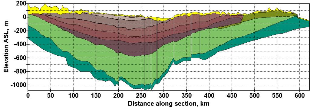
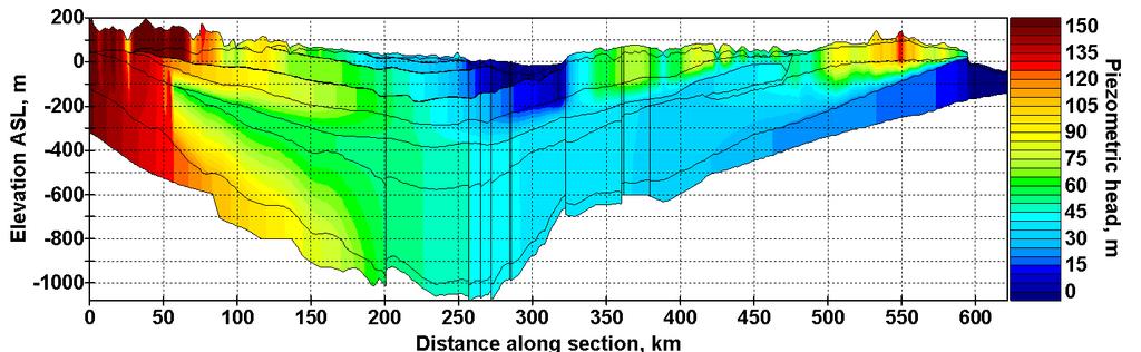


13 Distribution of piezometric head in south-north vertical crossection South Riga North
14 Summary Data for the bulding of regional model of Baltic artesian basin has been collected and prepared Geometry model of the Baltic artesian basin geological structure is developed, consisting of 24 layers Steady-state hydrogeological model has been set-up and calibrated The distribution of piezometric heads and principal flows inside BAB was analyzed based on the model results The present work has been funded by the European Social Fund project Establishment of interdisciplinary scientist group and modelling system for groundwater research (Project Nr.2009/0212/1DP/ /09/APIA/VIAA/060)
MECHANISMS OF GROUNDWATER RECHARGE IN THE BALTIC ARTESIAN BASIN
 and modelling system for groundwater research MECHANISMS OF GROUNDWATER RECHARGE IN THE BALTIC ARTESIAN BASIN Alise BABRE 1, Rein VAIKMÄE 2, Tõnu MARTMA 2, Konrāds POPOVS 1, Aija DĒLIŅA 1 1 University
WP2 country review Lithuania
 Saulius Sliaupa Rasa Sliaupiene institute of Geology and Geography WP2 country review Lithuania CO 2 emission in Lithuania (2005) 94 sources listed in the CO2 trading system of Lithuania in 2005 CO 2 emissions
FORMATION OF GROUNDWATER IN SEDIMENTARY BASINS: TRADITIONAL AND ALTERNATIVE MODELS
 FORMATION OF GROUNDWATER IN SEDIMENTARY BASINS: TRADITIONAL AND ALTERNATIVE MODELS Albertas Bitinas Klaipėda University, Coastal Research and Planning Institute, H. Manto St. 84, Klaipėda, Lithuania, albertas.bitinas@corpi.ku.lt
Saulius Šliaupa, Rasa Šliaupienė (NRC, Lithuania) Uldis Nulle, Inara Nulle (LEGMC, Latvia) Alla Shogenov, Kazbulat Shogenov (IGTUT, Estonia)
 Uldis Nulle, Inara Nulle (LEGMC, Latvia) Alla Shogenov, Kazbulat Shogenov (IGTUT, Estonia)") CO 2 Capture and Storage Response to Climate Change CGS Europe workshop 13 14 April 2011, Vilnius - Verkiai, Lithuania CO 2 storage potential of deep saline aquifers of the Baltic region Saulius Šliaupa,
CO 2 Capture and Storage Response to Climate Change CGS Europe workshop 13 14 April 2011, Vilnius - Verkiai, Lithuania CO 2 storage potential of deep saline aquifers of the Baltic region Saulius Šliaupa,
IPMO2-1. Groundwater Modelling of Chiang Rai Basin, Northern Thailand. Sattaya Intanum* Dr.Schradh Saenton**
 IPMO2-1 Groundwater Modelling of Chiang Rai Basin, Northern Thailand Sattaya Intanum* Dr.Schradh Saenton** ABSTRACT Chiang Rai basin, situated in Chiang Rai and Phayao provinces covering an area of 11,000
Next steps for verifying European CO2 storage capacity Perspectives from the Baltic Region
 Next steps for verifying European CO2 storage capacity Perspectives from the Baltic Region Adam WÓJCICKI 11 h #CO 2 GeoNet#Open#Forum,"May$9$ $11,$2016$ $Venice,$San$Servolo$Island$ CO2 storage research
UPGRADING OF THE HYDROGEOLOGICAL MODEL OF LATVIA
 UPGRADING OF THE HYDROGEOLOGICAL MODEL OF LATVIA Aivars Spalvins, Janis Slangens, Inta Lace, Kaspars Krauklis, Olgerts Aleksans Environment Modelling Centre Riga Technical University ¼ Meza str., Riga,
HEAT TRANSFER IN A LOW ENTHALPY GEOTHERMAL WELL
 HEAT TRANSFER IN A LOW ENTHALPY GEOTHERMAL WELL Marcel Rosca University of Oradea, Armata Romana 5, RO-37 Oradea, Romania Key Words: low enthalpy, numerical modeling, wellbore heat transfer, Oradea reservoir,
Origin and Evolution of Formation Waters in the West-Central Part of the Alberta Basin
 Page No. 004-1 Origin and Evolution of Formation Waters in the West-Central Part of the Alberta Basin Karsten Michael* University of Alberta, 1-26 ESB, Edmonton, AB T6G 2E3 karsten@ualberta.ca and Stefan
1.72, Groundwater Hydrology Prof. Charles Harvey Lecture Packet #5: Groundwater Flow Patterns. Local Flow System. Intermediate Flow System
 1.72, Groundwater Hydrology Prof. Charles Harvey Lecture Packet #5: Groundwater Flow Patterns c Local Flow System 10,000 feet Intermediate Flow System Regional Flow System 20,000 feet Hydrologic section
Soils, Hydrogeology, and Aquifer Properties. Philip B. Bedient 2006 Rice University
 Soils, Hydrogeology, and Aquifer Properties Philip B. Bedient 2006 Rice University Charbeneau, 2000. Basin Hydrologic Cycle Global Water Supply Distribution 3% of earth s water is fresh - 97% oceans 1%
Chapter 8 Fetter, Applied Hydrology 4 th Edition, Geology of Groundwater Occurrence
 Chapter 8 Fetter, Applied Hydrology 4 th Edition, 2001 Geology of Groundwater Occurrence Figure 8.42. Alluvial Valleys ground-water region. Fetter, Applied Hydrology 4 th Edition, 2001 Fetter, Applied
' International Institute for Land Reclamation and Improvement. 2 Groundwater Investigations. N.A. de Ridder'? 2.1 Introduction. 2.
 2 Groundwater Investigations N.A. de Ridder'? 2.1 Introduction Successful drainage depends largely on a proper diagnosis of the causes of the excess water. For this diagnosis, one must consider: climate,
HYDROGEOLOGICAL CONCEPTUAL MODEL OF A COMPLEX AQUIFER SYSTEM CENTRAL KALAHARI BASIN (BOTSWANA) DATE: 27 OCTOBER 2016 VENUE: GICC
 DATE: 27 OCTOBER 2016 VENUE: GICC") HYDROGEOLOGICAL CONCEPTUAL MODEL OF A COMPLEX AQUIFER SYSTEM CENTRAL KALAHARI BASIN (BOTSWANA) DATE: 27 OCTOBER 2016 VENUE: GICC MR. M. LEKULA DR. M.W. LUBCZYNSKI PROF. E.M. SHEMANG PRESENTATION OUTLINE
HYDROGEOLOGICAL CONCEPTUAL MODEL OF A COMPLEX AQUIFER SYSTEM CENTRAL KALAHARI BASIN (BOTSWANA) DATE: 27 OCTOBER 2016 VENUE: GICC MR. M. LEKULA DR. M.W. LUBCZYNSKI PROF. E.M. SHEMANG PRESENTATION OUTLINE
11/22/2010. Groundwater in Unconsolidated Deposits. Alluvial (fluvial) deposits. - consist of gravel, sand, silt and clay
 deposits. - consist of gravel, sand, silt and clay") Groundwater in Unconsolidated Deposits Alluvial (fluvial) deposits - consist of gravel, sand, silt and clay - laid down by physical processes in rivers and flood plains - major sources for water supplies
Groundwater in Unconsolidated Deposits Alluvial (fluvial) deposits - consist of gravel, sand, silt and clay - laid down by physical processes in rivers and flood plains - major sources for water supplies
P228 Geological Storage of CO2 Prospects in the Baltic States
 P228 Geological Storage of CO2 Prospects in the Baltic States A. Shogenova* (Tallinn University of Technology), S. Sliaupa (Institute of Geology and Geography, Vilnius), K. Shogenov (Tallinn University
The Nubian Sandstone Aquifer System. Martina Müller Claudia Dengler Felix Leicht
 The Nubian Sandstone Aquifer System Martina Müller Claudia Dengler Felix Leicht Geography Transboundary groundwater system beneath the north-eastern Sahara total extension of over 2.2 Mio km² Shared between
Biology. Slide 1 of 40. End Show. Copyright Pearson Prentice Hall
 Biology 1 of 40 2 of 40 Fossils and Ancient Life What is the fossil record? 3 of 40 Fossils and Ancient Life The fossil record provides evidence about the history of life on Earth. It also shows how different
Hydrogeology of East-Central Union County, Northeastern New Mexico
 Hydrogeology of East-Central Union County, Northeastern New Mexico Geoffrey Rawling April 2013 New Mexico Bureau of Geology & Mineral Resources 1 What are the important hydrogeologic issues in Union County?
Reconstructing the Groundwater Flow in the Baltic Basin During the Last Glaciation
 ESF projekts Starpnozaru zinātnieku grupas un modeļu sistēmas izveide pazemes ūdeņu pētījumiem Reconstructing the Groundwater Flow in the Baltic Basin During the Last Glaciation Tomas Saks, Juris Seņņikovs,
Modern geodynamic model of the Arctic Ocean
 Modern geodynamic model of the Arctic Ocean O. Petrov, N. Sobolev, A. Morozov, G. Grikurov, S. Shokalsky, S. Kashubin, E. Petrov Vienna, April 2012 Atlas of Geological Maps of the Circumpolar Arctic Magnetic
Evolution of the conceptual hydrogeologic and ground-water flow model for Las Vegas Valley, Clark County, Nevada
 Evolution of the conceptual hydrogeologic and ground-water flow model for Las Vegas Valley, Clark County, Nevada Geological Society of America Annual Meeting November 14, 2 David J. Donovan Southern Nevada
GY 111: Physical Geology
 UNIVERSITY OF SOUTH ALABAMA GY 111: Physical Geology Lecture 21: Rock Deformation Instructor: Dr. Douglas W. Haywick Last Time A) How long is long? B) Geological time divisions Web notes 20 Geological
EVALUATION OF AQUIFER CHARACTERISTICS FOR SELECTED NEW METHOD OF THE UM RUWABA FORMATION: NORTH KORDOFAN STATE, SUDAN
 EVALUATION OF AQUIFER CHARACTERISTICS FOR SELECTED NEW METHOD OF THE UM RUWABA FORMATION: NORTH KORDOFAN STATE, SUDAN ELHAGA.B *1; ELZIENS.M*2 ANDLISSANN.H*3 *1Department of C i v i l E n g i n e e r i
Geoelectric power generation prospects in Lithuania
 Geoelectric power generation prospects in Lithuania Saulius Šliaupa Nature research centre Develop Geothermal Electricity in Europe to have a renewable energy mix Workshop Lithuania, Latvia, Estonia, Finland,
WWDC Green River Basin Plan II, Groundwater Study (Level I) WSGS USGS WRDS October 23, 2008 Green River Basin (GRB) Basin Advisory Group
 WSGS USGS WRDS October 23, 2008 Green River Basin (GRB) Basin Advisory Group") WWDC Green River Basin Plan II, Groundwater Study (Level I) WSGS USGS WRDS 2007-20092009 October 23, 2008 Green River Basin (GRB) Basin Advisory Group (BAG) Western Wyoming Community College, Rock Springs,
WWDC Green River Basin Plan II, Groundwater Study (Level I) WSGS USGS WRDS 2007-20092009 October 23, 2008 Green River Basin (GRB) Basin Advisory Group (BAG) Western Wyoming Community College, Rock Springs,
GEOLOGY GL1 Foundation Unit
 Candidate Name Centre Number Candidate Number 2 General Certificate of Education Advanced Subsidiary/Advanced 451/01 GEOLOGY GL1 Foundation Unit P.M. THURSDAY, 10 January 2008 (1 hour) Examiner Question
Assessing our untapped energy resources. Derek Reay Geological Survey of Northern Ireland
 Assessing our untapped energy resources Derek Reay Geological Survey of Northern Ireland Talk Outline Northern Ireland energy market Oil and Gas Exploration Description Exploration risks Application of
Galilee Basin. Galilee Basin Hydrogeological Investigations. Briefing to RAPAD Longreach, 16 May rpsgroup.com.au
 Galilee Basin Galilee Basin Hydrogeological Investigations Briefing to RAPAD Longreach, 16 May 20116 1 The Galilee Basin Geologically & hydrogeological diverse sedimentary Covers 247,000 km 2 The Galilee
GPR AS A COST EFFECTIVE BEDROCK MAPPING TOOL FOR LARGE AREAS. Abstract
 GPR AS A COST EFFECTIVE BEDROCK MAPPING TOOL FOR LARGE AREAS Dr. Jutta L. Hager, Hager GeoScience, Inc., Waltham, MA Mario Carnevale, Hager GeoScience, Inc., Waltham, MA Abstract Hager GeoScience, Inc.
Hydrogeology and Simulated Effects of Future Water Use and Drought in the North Fork Red River Alluvial Aquifer: Progress Report
 Hydrogeology and Simulated Effects of Future Water Use and Drought in the North Fork Red River Alluvial Aquifer: Progress Report Developed in partnership with the Oklahoma Water Resources Board S. Jerrod
1. Why we need transboundary storage? Emissions versus storage capacity CCS Legislation Results versus emissions and storage capacity
 1. Why we need transboundary storage? Emissions versus storage capacity CCS Legislation Results versus emissions and storage capacity 2. Modelling of transboundary storage and prospective structures in
SwedSTORE CO2 : Plans for a Swedish onshore test site for CO 2 storage via seismic surveying and drilling on Gotland, Sweden
 SwedSTORE CO2 : Plans for a Swedish onshore test site for CO 2 storage via seismic surveying and drilling on Gotland, Sweden Christopher Juhlin (Uppsala University) 1 SwedSTORE CO2 Goals Advance methods
Differentiation of chloride source using stable chlorine isotopes
 Differentiation of chloride source using stable chlorine isotopes RemTech 2009 Banff, Alberta October 14-16 2009 Dr. Alec Blyth and Tom Anthony 1 1 currently City of Calgary Background: DOW Chemical Canada
IRAQ. Target Exploration. Geodynamic Evolutions of The Sedimentary Basins of. This study is a major reference for Petroleum
 barr Target Exploration Target Exploration Geodynamic Evolutions of The Sedimentary Basins of IRAQ This study is a major reference for Petroleum Explorationists on the tectonics, stratigraphy, sedimentary
THE MOST PROSPECTIVE AREAS OF USE OF THERMAL WATERS FOR HEATING PURPOSES IN THE POLISH LOWLANDS
 BIULETYN PAÑSTWOWEGO INSTYTUTU GEOLOGICZNEGO 441: 27 32, 2010 R. THE MOST PROSPECTIVE AREAS OF USE OF THERMAL WATERS FOR HEATING PURPOSES IN THE POLISH LOWLANDS MAREK HAJTO 1,WOJCIECH GÓRECKI 1 Abstract.
Galilee Basin Mining and Groundwater
 Galilee Basin Mining and Groundwater Impact on the Great Artesian Basin John Hillier Acknowledgements Some diagrams used in this presentation have been obtained from: EIS for proposed mining ventures A
Groundwater Hydrology
 EXERCISE 12 Groundwater Hydrology INTRODUCTION Groundwater is an important component of the hydrologic cycle. It feeds lakes, rivers, wetlands, and reservoirs; it supplies water for domestic, municipal,
GEOLOGICAL STORAGE OF INDUSTRIAL CO 2 EMISSIONS IN THE BALTIC STATES: PROBLEMS AND PROSPECTS
 GEOLOGICAL STORAGE OF INDUSTRIAL CO 2 EMISSIONS IN THE BALTIC STATES: PROBLEMS AND PROSPECTS Alla Shogenova 1, Saulius Sliaupa 2,3, Kazbulat Shogenov 1 Rasa Sliaupiene 2, Rein Vaher 1 and Angelina Zabele
Surface Processes Focus on Mass Wasting (Chapter 10)
") Surface Processes Focus on Mass Wasting (Chapter 10) 1. What is the distinction between weathering, mass wasting, and erosion? 2. What is the controlling force in mass wasting? What force provides resistance?
Surface Processes Focus on Mass Wasting (Chapter 10) 1. What is the distinction between weathering, mass wasting, and erosion? 2. What is the controlling force in mass wasting? What force provides resistance?
Hydrogeological Studies and Mapping on West Milan Area
 Hydrogeological Studies and Mapping on West Milan Area R.Bergamo, W.Danieli, D.de Bartolo, A.P.Gatti ARPA Lombardia, Dipartimento di Milano 1, Area di Tutela Ambientale Via Spagliardi 19, 20015 Parabiago
P105 Particularities of Astrakhan Gas Field Deep Structure Resulting from Microseismic Sounding Technique Application
 P105 Particularities of Astrakhan Gas Field Deep Structure Resulting from Microseismic Sounding Technique Application A.V. Gorbatikov* (Institute of Physics of the Earth, Rus.Acad.Sci.), M.Y. Stepanova
2SEA. Requirements Report SOILS2SEA DELIVERABLE NO. 1.2
 SOILS2SEA DELIVERABLE NO. 1.2 Requirements Report 2SEA Reducing nutrient loadings from agricultural soils to the Baltic Sea via groundwater and streams 3.5 Baltic Sea Basin 3.5.1 Description The Baltic
4.11 Groundwater model
 4.11 Groundwater model 4.11 Groundwater model 4.11.1 Introduction and objectives Groundwater models have the potential to make important contributions in the mapping and characterisation of buried valleys.
Ground and Intermediate Water Equilibrium with Water- Bearing Rock Minerals (Moldova) under Anthropogenic Impact
 under Anthropogenic Impact") Ground and Intermediate Water Equilibrium with Water- Bearing Rock Minerals (Moldova) under Anthropogenic Impact А N Timoshenkova 1, C Ye Moraru 2, Ye Yu Pasechnik 3, О G Tokarenko 4 and V А Butoshina
Ground and Intermediate Water Equilibrium with Water- Bearing Rock Minerals (Moldova) under Anthropogenic Impact А N Timoshenkova 1, C Ye Moraru 2, Ye Yu Pasechnik 3, О G Tokarenko 4 and V А Butoshina
Structural Geology of the Mountains
 Structural Geology of the Mountains Clinton R. Tippett Shell Canada Limited, Calgary, Alberta clinton.tippett@shell.ca INTRODUCTION The Southern Rocky Mountains of Canada (Figure 1) are made up of several
Groundwater Rebound in the South Yorkshire Coalfield: A review of initial modelling
 Groundwater Rebound in the South Yorkshire Coalfield: A review of initial modelling 1 S. P. Burke, 1 H. A.B. Potter and 2 A. Jarvis 1 Environment Agency: Science Group, Olton Court, Olton,Solihull UK 2
A Remote Sensing Approach to Characterize the Hydrogeology of Mountainous Areas: Application to the Quito Aquifer System (QAS), Ecuador
, Ecuador") A Remote Sensing Approach to Characterize the Hydrogeology of Mountainous Areas: Application to the Quito Aquifer System (QAS), Ecuador Dissertation Research Proposal PIRE 0530109 Miriam Rios Sánchez July
A Remote Sensing Approach to Characterize the Hydrogeology of Mountainous Areas: Application to the Quito Aquifer System (QAS), Ecuador Dissertation Research Proposal PIRE 0530109 Miriam Rios Sánchez July
International Workshop on Groundwater Systems in Europe, August, 2013 Berlin
 Hydrogeological Mapping in Albania From the IHME contribution to larger scale national maps R. Eftimi, I. Tafilaj, G. Bisha & Xh. Sheganaku Mali me Gropa karst plateau Selita spring The hydrogeological
https://gsa.confex.com/gsa/2014am/webprogram/paper html
 Abstract: IMPACT OF PALEOZOIC KARST UPON GROUNDWATER FLOW IN TH... https://gsa.confex.com/gsa/2014am/webprogram/paper244571.html Page 1 of 1 28/08/2014 Start Author Index Meeting Information Paper No.
GCE AS/A level 1211/01 GEOLOGY GL1 Foundation Unit
 Surname Centre Number Candidate Number Other Names 2 GCE AS/A level 1211/01 GEOLOGY GL1 Foundation Unit A.M. TUESDAY, 13 May 2014 1 hour For s use Question Maximum Mark 1. 17 2. 14 Mark Awarded 1211 010001
Hydraulic and Water-Quality Characterization of Fractured-Rock Aquifers Using Borehole Geophysics
 Hydraulic and Water-Quality Characterization of Fractured-Rock Aquifers Using Borehole Geophysics John H. Williams Office of Ground Water Troy, New York Flow in Open Borehole Runkel and others (2003) Ambient
Finding Large Capacity Groundwater Supplies for Irrigation
 Finding Large Capacity Groundwater Supplies for Irrigation December 14, 2012 Presented by: Michael L. Chapman, Jr., PG Irrigation Well Site Evaluation Background Investigation Identify Hydrogeologic Conditions
Lab 4: Structures and Geologic Maps
 Key Questions: GEOL 1311 Earth Science Lab 4 Structures and Geologic Maps What shapes do rock bodies take in the Earth? How do two-dimensional visualizations of the Earth, such as maps and cross-sections
Petroleum Systems (Part One) Source, Generation, and Migration
 Source, Generation, and Migration") Petroleum Systems (Part One) Source, Generation, and Migration GEOL 4233 Class January 2008 Petroleum Systems Elements Source Rock Migration Route Reservoir Rock Seal Rock Trap Processes Generation Migration
Petroleum Systems (Part One) Source, Generation, and Migration GEOL 4233 Class January 2008 Petroleum Systems Elements Source Rock Migration Route Reservoir Rock Seal Rock Trap Processes Generation Migration
Las Vegas Valley is a fault-bounded basin containing hundreds of metres of Tertiary and Quaternary sediments derived from lacustrine, paludal, and
 Land Subsidence (Proceedings of the Fourth International Symposium on Land Subsidence, May 1991). IAHS Publ. no. 200, 1991. Elevation Changes Associated with Subsidence in Las Vegas Valley, Nevada JOHN
Saltwater injection into a fractured aquifer: A density-coupled mass-transport model
 Saltwater injection into a fractured aquifer: A density-coupled mass-transport model Junfeng Luo 1, Martina aus der Beek 2, Joachim Plümacher 2, Sven Seifert 1, Bertram Monninkhoff 1 1 DHI-WASY GmbH, Volmerstr.
2. Governing Equations. 1. Introduction
 Multiphysics Between Deep Geothermal Water Cycle, Surface Heat Exchanger Cycle and Geothermal Power Plant Cycle Li Wah Wong *,1, Guido Blöcher 1, Oliver Kastner 1, Günter Zimmermann 1 1 International Centre
Report on Bad Radkersburg Hodoš pilot area model
 Report on Bad Radkersburg Hodoš pilot area model Authors: Tadej Fuks, Mitja Janža, Dejan Šram and Andrej Lapanje in cooperation with MAFI, GBA Date Status Type 31-Januar-2013 final Text Description The
River Processes. Drainage Basin Morphometry
 Drainage Basin Morphometry River Processes Morphometry - the measurement and mathematical analysis of the configuration of the earth s surface and of the shape and dimensions of its landforms. Horton (1945)
Long term piezometric data analysis to validate landslide models
 Long term piezometric data analysis to validate landslide models M.G. Angeli C.N.R. Institute, Perugia, Italy P. Gasparetto IQT Consulting S.r.l., Rovigo, Italy F. Pontoni Geoequipe S.T.A., Tolentino,
Update on the BASTOR Project Richard Vernon
 Update on the BASTOR Project Richard Vernon Principal, Energy SLR Consulting 23 rd May 2013 OUTLINE Introduction What is the BASTOR Project? SLR s Current Assignment Activities to date Current findings
Land subsidence induced by groundwater extraction in the Alto Guadalentín aquifer, SE Spain.
 Land subsidence induced by groundwater extraction in the Alto Guadalentín aquifer, SE Spain. Pablo Ezquerro, Marta Béjar-Pizarro, Gerardo Herrera, José A. Fernández Merodo, Roberto Tomás, Carolina Guardiola-Albert,
Country Fiche Latvia Updated October 2016
 Country Fiche Latvia Updated October 2016 1. General information Marine area under Latvian jurisdiction includes inland sea waters, Territorial sea (12 nautical miles from the baseline) and exclusive economic
NAME OF THE PROGRAMME : M.Sc. GEOLOGY PROGRAMME OUTCOME
 NAME OF THE PROGRAMME : M.Sc. GEOLOGY PROGRAMME OUTCOME 1. Understanding development of landforms through Earth's external processes by various geological agents; marine processes and formation of marine
Tuesday 6 June 2017 Afternoon
 Oxford Cambridge and RSA Tuesday 6 June 2017 Afternoon A2 GCE GEOLOGY F794/01 Environmental Geology *6783378785* Candidates answer on the Question Paper. OCR supplied materials: None Other materials required:
17-1 The Fossil Record Slide 1 of 40
 1 of 40 Fossils and Ancient Life Fossils and Ancient Life Paleontologists are scientists who collect and study fossils. All information about past life is called the fossil record. The fossil record includes
IN POLAND. Adam WÓJCICKI. National Research Institute
 CO2 GEOLOGICAL STORAGE POTENTIAL IN POLAND Adam WÓJCICKI Polish Geological Institute National Research Institute Warsaw, June 2009 CO2 geological sequestration (definitions) Carbon capture and storage
«Near Surface Geothermal Resources in the Territory of the Alpine Space» Pilot Study Switzerland, Davos
 Departement Umweltwissenschaften «Near Surface Geothermal Resources in the Territory of the Alpine Space» Pilot Study Switzerland, Davos Peter Huggenberger Stefan Scheidler Birte Anders Projectpartners:
Saline water intrusion monitoring and control at Guves Prefecture - Crete
 Saline water intrusion monitoring and control at Guves Prefecture - Crete G-Akis Tselentis% George Kallergis*, Iraklis Bulukakis^, George Delis* and Paraskevas Paraskevopoulos* (1) University of Patras,
FORENSIC GEOLOGY A CIVIL ACTION
 NAME 89.215 - FORENSIC GEOLOGY A CIVIL ACTION I. Introduction In 1982 a lawsuit was filed on behalf of eight Woburn families by Jan Schlictmann. The suit alleged that serious health effects (childhood
Geological Survey of Alabama Groundwater Assessment Program
 Geological Survey of Alabama Groundwater Assessment Program Hydrogeologic Characterization and Groundwater Source Development Assessment for Area 2, Southwestern Alabama Gheorghe M. Ponta, Marlon R. Cook,
A. Baiocchi 1, W. Dragoni 2, F. Lotti 1, S.M. Piacentini 2, V. Piscopo 1
 A. Baiocchi 1, W. Dragoni 2, F. Lotti 1, S.M. Piacentini 2, V. Piscopo 1 (1) Department of Ecological and Biological Sciences, University of Tuscia, Viterbo, Italy (2) Department of Physics and Geology,
The Capitan Aquifer - Ellenburger Production Wells Geothermal Engine Source?
 GEOTHERMAL ENERGY UTILIZATION ASSOCIATED WITH OIL & GAS DEVELOPMENT June 17-18, 2008 Southern Methodist University Dallas, Texas The Capitan Aquifer - Ellenburger Production Wells Geothermal Engine Source?
XXXVIII IAH Congress
 XXXVIII IAH Congress Groundwater Quality Sustainability Krakow, 12 17 September 2010 Extended Abstracts Editors: Andrzej Zuber Jarosław Kania Ewa Kmiecik University of Silesia Press 2010 abstract id: 384
STORAGE POTENTIAL OF POLAND (THE BALTIC BASIN) Adam Wójcicki & Jolanta Pacześna, PGI-NRI
 Adam Wójcicki & Jolanta Pacześna, PGI-NRI") STORAGE POTENTIAL OF POLAND (THE BALTIC BASIN) Adam Wójcicki & Jolanta Pacześna, PGI-NRI.. Espoo, 23.05.2013 CO2 storage projects Poland and Europe 1995-..Borzęcin gas field (acidic gas 60% CO2; INiG,
STORAGE POTENTIAL OF POLAND (THE BALTIC BASIN) Adam Wójcicki & Jolanta Pacześna, PGI-NRI.. Espoo, 23.05.2013 CO2 storage projects Poland and Europe 1995-..Borzęcin gas field (acidic gas 60% CO2; INiG,
Framework for incorporating spectral observations into steady state analysis of groundwater discharge around the margins of the Great Artesian Basin
 18 th World IMACS / MODSIM Congress, Cairns, Australia 13-17 July 2009 http://mssanz.org.au/modsim09 Framework for incorporating spectral observations into steady state analysis of groundwater discharge
RESISTIVITY IMAGING AND BOREHOLE INVESTIGATION OF THE BANTING AREA AQUIFER, SELANGOR, MALAYSIA. A.N. Ibrahim Z.Z.T. Harith M.N.M.
 JOURNAL OF ENVIRONMENTAL HYDROLOGY The Electronic Journal of the International Association for Environmental Hydrology On the World Wide Web at http://www.hydroweb.com VOLUME 11 2003 RESISTIVITY IMAGING
The Fossil Record. CELLS and HEREDITY, CHAPTER 5, SECTION 3, PAGES 155 to 163
 The Fossil Record CELLS and HEREDITY, CHAPTER 5, SECTION 3, PAGES 155 to 163 Objectives 1. Describe how most fossils form. 2. Explain how scientists can determine a fossil s age. 3. Identify some unanswered
Figure 1 Double-mass plots of precipitation at White Bear Lake from three gridded data sets (Daymet, HIDEN, and PRISM) versus the Minnesota Climate
 versus the Minnesota Climate") Figure 1 Double-mass plots of precipitation at White Bear Lake from three gridded data sets (Daymet, HIDEN, and PRISM) versus the Minnesota Climate Division 6 average. Straight lines through the plots
Figure 1 Double-mass plots of precipitation at White Bear Lake from three gridded data sets (Daymet, HIDEN, and PRISM) versus the Minnesota Climate Division 6 average. Straight lines through the plots
HYDROGEOLOGICAL CHARACTERISTICS OF THE LOWER SILESIAN COAL BASIN. Posya:ek Ewa Central Mining Institute, Katowice ABSTRACT
 HYDROGEOLOGICAL CHARACTERISTICS OF THE LOWER SILESIAN COAL BASIN Posya:ek Ewa Central Mining Institute, Katowice ABSTRACT The Lower Silesian Coal Basin is one of the smaller mining a reas in Poland in
3. The diagram below shows how scientists think some of Earth's continents were joined together in the geologic past.
 1. The map below shows the present-day locations of South America and Africa. Remains of Mesosaurus, an extinct freshwater reptile, have been found in similarly aged bedrock formed from lake sediments
2 Geology. 2.1 Elements of Terrane Analysis. Terrane or Terrain? Potential receptors
 2 Geology Knowledge of fractured rock geology, or terrane, provides important context for investigating contaminated sites. Tectonic forces impart characteristic structures on rock formations that influence
Land subsidence due to groundwater withdrawal in Hanoi, Vietnam
 Land Subsidence (Proceedings of the Fifth International Symposium on Land Subsidence, The Hague, October 1995). 1AHS Publ. no. 234, 1995. 55 Land subsidence due to groundwater withdrawal in Hanoi, Vietnam
Tectonically conditioned brine leakage into usable freshwater aquifers implications for the quality of groundwater exploited in central Poland
 Tectonically conditioned brine leakage into usable freshwater aquifers implications for the quality of groundwater exploited in central Poland Dorota Kaczor-Kurzawa 1 1 Polish Geological Institute National
Evaluating Geological Formations and Managing Ground-Water Resources: Can We Afford the Effort?
 Evaluating Geological Formations and Managing Ground-Water Resources: Can We Afford the Effort? Stanley T. Paxton & Todd Halihan Oklahoma State University GSA Annual Meeting Salt Lake City, Utah 16-19
Chapter 14: Groundwater. Fig 14.5b
 Chapter 14: Groundwater Fig 14.5b OBJECTIVES Recognize that groundwater is a vital source of accessible freshwater. Describe how groundwater forms below the water table. Explain the origin of aquifers,
HYDROGEOLOGICAL PROPERTIES OF THE UG2 PYROXENITE AQUIFERS OF THE BUSHVELD COMPLEX
 R. Gebrekristos, P.Cheshire HYDROGEOLOGICAL PROPERTIES OF THE UG2 PYROXENITE AQUIFERS OF THE BUSHVELD COMPLEX R. Gebrekristos Digby Wells Environmental P. Cheshire Groundwater Monitoring Services Abstract
1 HYDROGEOLOGY AND AQUIFER CHARACTERISTICS
 1 HYDROGEOLOGY AND AQUIFER CHARACTERISTICS 1.1 DEFINITIONS Groundwater is one of the smallest components of the hydrosphere. Groundwater flow and the inherent hydrochemical processes belong to the hydrological
Country review Estonia
 Country review Estonia Alla Shogenova 1, Kazbulat Shogenov 1, Raisa Pomeranceva 2, Filip Neele 3, Chris Hendriks 4 1 Institute of Geology, Tallinn University of Technology, Estonia, alla@gi.ee 2 Latvian
Groundwater Vulnerability Mapping Eastern Newfoundland Executive Summary
 Groundwater Vulnerability Mapping Eastern Newfoundland Executive Summary 123102.00 Executive Summary March 2014 ISO 9001 Registered Company Prepared for: Water Resources Management Division Department
Name HW - Landscapes
 Name HW - Landscapes 1. New York s Tug Hill landscape region is classified as a plateau because this region has a A) high elevation with distorted bedrock B) high elevation with nearly horizontal layers
Evaluation of Subsurface Formation of Pabna District, Bangladesh
 IOSR Journal of Applied Geology and Geophysics (IOSR-JAGG) e-issn: 2321 0990, p-issn: 2321 0982.Volume 1, Issue 4 (Sep. Oct. 2013), PP 30-36 Evaluation of Subsurface Formation of Pabna District, Bangladesh
Saltwater intrusions in the low-lying coastal areas of South-Western Jutland
 Saltwater intrusions in the low-lying coastal areas of South-Western Jutland Rena Meyer* Peter Engesgaard*, Torben O. Sonnenborg^ *University of Copenhagen, Denmark ^Geological Survey of Denmark and Greenland,
Surface Water and Stream Development
 Surface Water and Stream Development Surface Water The moment a raindrop falls to earth it begins its return to the sea. Once water reaches Earth s surface it may evaporate back into the atmosphere, soak
SASKATCHEWAN STRATIGRAPHY GLACIAL EXAMPLE BOULDERS IN GLACIAL DEPOSITS
 SASKATCHEWAN STRATIGRAPHY GLACIAL EXAMPLE BOULDERS IN GLACIAL DEPOSITS 51 SASKATCHEWAN STRATIGRAPHY GLACIAL SURFICIAL STRATIFIED DEPOSITS 52 SASKATCHEWAN STRATIGRAPHY GLACIAL EXAMPLE OF SEDIMENT DEPOSITION
PRECAMBRIAN CRYSTALLINE AQUIFER (METAMORPHIC ROCKS)
") HAYWARD QUADRANGLE: Groundwater Production by Aquifer In the 56-square-mile area of the Hayward Quadrangle, groundwater is produced from metamorphic crystalline rocks of the Precambrian basement (in the
HAYWARD QUADRANGLE: Groundwater Production by Aquifer In the 56-square-mile area of the Hayward Quadrangle, groundwater is produced from metamorphic crystalline rocks of the Precambrian basement (in the
Basin-Scale Hydrological Impact of Geologic Carbon Sequestration in the Illinois Basin: A Full-Scale Deployment Scenario
 Basin-Scale Hydrological Impact of Geologic Carbon Sequestration in the Illinois Basin: A Full-Scale Deployment Scenario Quanlin Zhou, Jens Birkholzer Earth Sciences Division Lawrence Berkeley National
A NOVEL APPROACH TO GROUNDWATER MODEL DEVELOPMENT. Thomas D. Krom 1 and Richard Lane 2
 A NOVEL APPROACH TO GROUNDWATER MODEL DEVELOPMENT Thomas D. Krom 1 and Richard Lane 2 1 Touch Water Ltd., P.O. Box 143, Lincoln, Christchurch, New Zealand; email: touchwater@gmail.com 2 Applied Research
Historical Geology GEL 102 Syllabus Spring, 2015
 Historical Geology GEL 102 Syllabus Spring, 2015 Dr. Jacob Sewall sewall@kutztown.edu 484-646-5864 http://faculty.kutztown.edu/sewall Boehm Bldg. 422 Office hours: M: 10 12, T: 9:30 10 W: 10 12, TH: 9:30