Ground-Water Flow through Porous Medium
|
|
|
- Reynold Summers
- 5 years ago
- Views:
Transcription
 Zone")

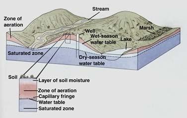
1 Soil & Ground Water Distribution Eastern USA Soil Moisture Belt Unsaturated (Vadose( = Aeration) Zone Capillary Fringe Water Table Saturated (Phreatic)) Zone Ground-Water Flow through Porous Medium Water Wells = Head
2 V = K h/l Darcy's Law Applied to movement of water through a permeable substance K = hydraulic conductivity in gal/day-ft 2 h/l = hydraulic gradient Darcy's Law V = K h/l K = hydraulic conductivity in gal/day-ft 2 since then Q = A V Q = A K h/l Darcy Constants Material clean clean sand vfsd silt unweathered gravel sandy gvl loams clays Aquifer GOOD POOR IMPERVIOUS Darcy K
3 Darcy's Law Example Given: pond with surface area of 1000 ft 2 and hydraulic gradient of 100 ft of rise in 100 ft of horizontal distance. Calculate the amount of water that would leak out of the pond if the bottom is (A) gravel with K = 10 6 or (B) clay with K = Q = A K h/l Pond 1000 ft 2 Darcy's Law Example Q = A K h/l 100 ft gravel K = 10 6 clay K = 10-3 Stream 100 ft Add Ohio Outwash Terrace Flow Net map, Show effects of well field for 2001
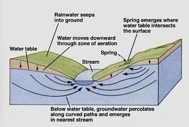
4 Ground-Water Flow Ground-Water Discharging into Stream Aquifer System


5 Oil Well Aquifer System Perched Aquifers Influent Stream Recharging Aquifer Kite Stream, Antarctic Polar Desert Steve Kite Photo


6 Artesian Aquifer Hot Ground-Water: 2 Methods Bring Heat Source near the Surface: Super-Heating and Boiling! Iceland, Yellowstone, etc. Take Water Deep below the Surface, Followed by Rapid Rise & Discharge Thermal Springs in the Virginias Old Faithful Geyser, Yellowstone NP


7 Pool in Upper Geyser Basin, Yellowstone Siliceous Sinter Fishing Cone Hot Spring, Yellowstone NP Minerva Travertine Terrace, Mammoth Hot Springs, Yellowstone NP
8 TYPICAL GEOTHERMAL GRADIENT 16.5 o C/km 48 o F/mi Average Worldwide Slow Deep Infiltration + Rapid Rise & Discharge Hot Springs, Virginia Average Air Temp. = ~52 o F Average Water Temp = ~106 o F How Far Down to Raise Water ~54 o F ~54 o F / (48 o F/mi) = 1.1 mile deep Water Must Rise to Surface Rapidly, or It Will Cool on Way to Surface Geology of White Sulphur Springs, WV Recharge Sulphur-Rich Black Shale Limestone Limestone Fault
9 Geology of White Sulphur Springs, WV Sulphur-Rich Black Shale Geothermal Heating Limestone Limestone Fault Geology of White Sulphur Springs, WV Sulphur-Rich Black Shale Limestone Fault Limestone Geology of White Sulphur Springs, WV Sulphur-Rich Black Shale Limestone Fault Limestone
10 Geology of White Sulphur Springs, WV Sulphur-Rich Black Shale Limestone Fault Limestone Geology of White Sulphur Springs, WV Nasty-Smelling, Hard, Warm Spring Sulphur-Rich Black Shale Limestone Fault Limestone Geology of White Sulphur Springs, WV $$$$ Sulphur-Rich Black Shale Limestone Fault Limestone

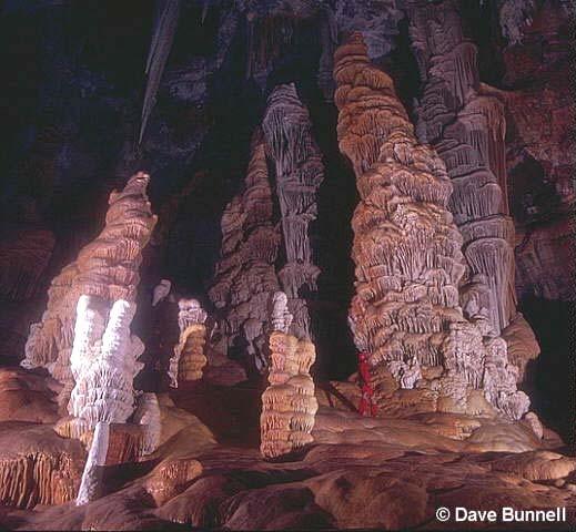
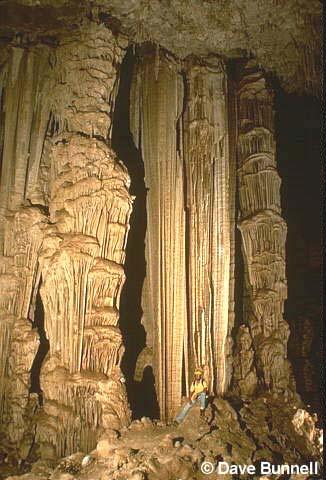
11 The Rock Organ Organ Cave, Greenbrier Co., WV Karst & Caves Carbonate Dissolution CaCO 3 + H 2 O+ CO 2 = CaCO 3 + H 2 CO 3 = Ca HCO - 3 (Dissolved Ions) Conditions Favoring Karst: 1. Lithology >60 % calcite, best if > 90 % calcite Best If Massive, Xline, Hard, Pure Limestone Shale in Thin Bedded Limestone = Ground-water Flow Barrier Rock Needs Strength to Support Karst Features

12 Conditions Favoring Karst: 1. Lithology 2. Available relief: permits vertical drainage component 3. Well-developed bedding or fractures Conditions Favoring Karst: 1. Lithology 2. Available relief 3. Well-developed bedding or fractures 4. >100m unit thickness 5. Humid, warm climate high CO 2 content (vegetation decomposition) rapid reactions (kinetics) Typical Limestone Outcrops in Karst Landscape

 near Mammoth Cave")


13 Variable Depth to Bedrock & Well Prospects ch_l/gif/l082.gif Sinkhole (Doline) near Mammoth Cave NP, KY Trout Pond: Sinkhole Exposed in Hardy Co., WV during August 2002 Pre-Draining vs. Post-Draining USFS Photo Photo: Lee Avery, WVGES Water Levels Dropped Several ft/day ~ 3 to 5 August 2002


14 Blue Ridge Foothills Karst Elevator! Depth to Bedrock may be >200 m usgs.gov/gwa/ ch_l/gif/l081.gif West East Grote, T.G., 2006, WVU PhD colluvium Qaf3 Pit 1 Pit 3 Pit 2 Qaf2 Qaf1 carbonate residuum karst features Cumberland Valley Sequence carbonate rocks Chilhowee Group metasedimentary rocks Florida Aquifer Miller, James A., 1990, GROUND WATER ATLAS of the UNITED STATES: Alabama, Florida, Georgia, South Carolina, USGS HA 730-G capp.water.usgs.gov/gwa/ ch_g/g-text6.html


15 Doline = Sinkhole near Echo River Spring, FL natu/mamc/sinkhole.htm Florida Sinkholes dynamic/groundwater/groundw ater.html Raders Valley, Greenbrier Co., WVa


16 Rders Valley Greenbrier Co, WV Detail Clastic Rx Where are Carbonate Rx? Where are Clastic Rx? Winterpark, Florida Sinkhole Swallows Porsche Dealership Miller, 1990, USGS HA 730-G


17 Guatemala City Sinkhole, 23 Feb 2007 Not for Web Reproduction Groundwater, Karst, and Caves LLORCA, JUAN CARLOS, Associated Press Guatemala City Sinkhole, 2007 Not for Web Reproduction LLORCA, JUAN CARLOS, Associated Press Tower Karst & Karren - China

18 Tower Karst - China Cave Passages Record History of Cave Development Styx River Resurgence Mammoth Cave NP, KY


19 River Resurgence in Wyoming gov/gwa/ch_l/gif/l083.gif Break Down, Mammoth Cave


20 Mammoth Cave Elliptical Tube Buckeye Cave, Greenbrier Co., WV, Greg Springer Website Elliptical Tube Partly Filled with Alluvial Sediments Photo 2001 by Ed McCarthy & Carl Samples. Vadose Tube: Looking Down, Mammoth Cave


21 Vadose Tube: Looking Up, Mammoth Cave Mammoth Cave Web Sites Cass Cave, photo by Tom Hay Vadose Canyon Leads into Phreatic Tube

22 Carbonate Dissolution CaCO 3 + H 2 O+ CO 2 = CaCO 3 + H 2 CO 3 = Ca HCO - 3 (Dissolved Ions) Carbonate Precipitation Ca HCO 3- = CaCO 3 + H 2 O+ CO 2 Travertine, Tufa, Marl Falling Spring Marl-Travertine Deposit, Rt. 220, Near Covington, Virginia Virginia Division of Mineral Resources Photo Dmr/GALLERY/historic/ Images/BWMORP/ bwcov.jpg


23 Falling Spring Marl-Travertine Deposit, Rt. 220, Near Covington, Virginia S. Kite Photo Stalactites and Stalagmites earth.com/ virtcave/ stalmite/ stalmite. html Travertine Precipitation Ca HCO 3 - = CaCO 3 + H 2 O+ CO 2 Degassing of CO 2


24 Ornamentation Stalactites Popcorn Popcorn Ornamentation Aragonite Xls Ornamentation
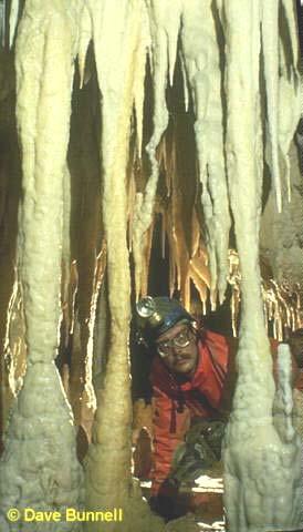
25 Stalagmites Columns Columns


26 Rim Stone Rim Stone, Stalactites, Stalagmites, Columns Ornamentation Speleothem Web Sites:


27 Rock Shelter in Baja Claifornia Meadowcroft Rock Shelter, Avella, PA April 1975 photo by Mark McConaughy MCCONAUGHY/web/ Meadowcroft/meadcr07.htm Meadowcroft Rock Shelter Today WQED Pittsburgh History Series


28 Meadowcroft Rock Shelter Roof-Fall Breakdown WQED Pittsburgh History Series Meadowcroft Rock Shelter Stratigraphy Sediment Sources: Rock Fall Blocks Grain Fall Rain Slopewash from Above Colluvium from Margins Anthropogenic Deposits For More on Meadowcroft and other Important Archeological Sites: /sites/northamerica/meadowcroft.html
Ground-Water Flow through Porous Medium. GEO 321 Lecture 14 Dr. J. S. Kite. Groundwater, Karst, and Caves
 GEO 321 Lecture 14 Dr. J. S. Kite The Rock Organ Organ Cave, Greenbrier Co., WV Groundwater, Karst, and Caves Soil & Ground Water Distribution Eastern USA Soil Moisture Belt Unsaturated (Aeration) Zone
Groundwater. (x 1000 km 3 /y) Reservoirs. Oceans Cover >70% of Surface. Groundwater and the. Hydrologic Cycle
 Reservoirs. Oceans Cover >70% of Surface. Groundwater and the. Hydrologic Cycle") Chapter 13 Oceans Cover >70% of Surface Groundwater and the Hydrologic Cycle Oceans are only 0.025% of Mass Groundwater Groundwater is liquid water that lies in the subsurface in fractures in rocks and
Chapter 13 Oceans Cover >70% of Surface Groundwater and the Hydrologic Cycle Oceans are only 0.025% of Mass Groundwater Groundwater is liquid water that lies in the subsurface in fractures in rocks and
Karst found mostly in limestone (rock with at least 50% carbonate minerals), depends on 1) permeability & porosity
, depends on 1) permeability & porosity") KARST LANDFORMS produced by weathering & erosion in regions of carbonate rocks and evaporites processes called karstification mainly below ground surface predominantly underground drainage poorly-developed
KARST LANDFORMS produced by weathering & erosion in regions of carbonate rocks and evaporites processes called karstification mainly below ground surface predominantly underground drainage poorly-developed
Solution Processes and. Karst Topography
 Solution Processes & Karst Topography Come forth into the light of things, Let Nature be your teacher. William Wordsworth 1 Solution Processes and Karst Topography The Impact of Solution Processes on the
Groundwater. (x 1000 km 3 /y) Oceans Cover >70% of Surface. Groundwater and the. Hydrologic Cycle
 Oceans Cover >70% of Surface. Groundwater and the. Hydrologic Cycle") Chapter 17 Oceans Cover >70% of Surface Groundwater and the Hydrologic Cycle Vasey s Paradise, GCNP Oceans are only 0.025% of Mass Groundwater Groundwater is liquid water that lies in the subsurface in
Chapter 17 Oceans Cover >70% of Surface Groundwater and the Hydrologic Cycle Vasey s Paradise, GCNP Oceans are only 0.025% of Mass Groundwater Groundwater is liquid water that lies in the subsurface in
Essentials of Geology, 11e
 Essentials of Geology, 11e Groundwater Chapter 10 Instructor Jennifer Barson Spokane Falls Community College Geology 101 Stanley Hatfield Southwestern Illinois Co Jennifer Cole Northeastern University
Chapter 13. Groundwater
 Chapter 13 Groundwater Introduction Groundwater is all subsurface water that completely fills the pores and other open spaces in rocks, sediments, and soil. Groundwater is responsible for forming beautiful
Groundwater. Earth Chapter 17
 Groundwater Earth Chapter 17 Chapter 17 Groundwater Importance of Groundwater Groundwater is water found in the pores of soil and sediment, plus narrow fractures in bedrock Groundwater and the Hydrosphere
 12 10 8 6 4 2 0 40-50 50-60 60-70 70-80 80-90 90-100 Fresh Water What we will cover The Hydrologic Cycle River systems Floods Groundwater Caves and Karst Topography Hot springs Distribution of water in
Chapter 14. Groundwater
 Chapter 14 Groundwater Importance of groundwater! Groundwater is water found in the pores of soil and sediment, plus narrow fractures in bedrock! Groundwater is the largest reservoir of fresh water that
EARTH SCIENCE 11 CHAPTER 9 NOTES WATER MOVING UNDERGROUND
 EARTH SCIENCE 11 CHAPTER 9 NOTES WATER MOVING UNDERGROUND KEY A. ALL THE WORLD S WATER 1. The world has an estimated one and one third thousand million cubic kilometers of water. 2. The earth s water is
11/22/2010. Groundwater in Unconsolidated Deposits. Alluvial (fluvial) deposits. - consist of gravel, sand, silt and clay
 deposits. - consist of gravel, sand, silt and clay") Groundwater in Unconsolidated Deposits Alluvial (fluvial) deposits - consist of gravel, sand, silt and clay - laid down by physical processes in rivers and flood plains - major sources for water supplies
Groundwater in Unconsolidated Deposits Alluvial (fluvial) deposits - consist of gravel, sand, silt and clay - laid down by physical processes in rivers and flood plains - major sources for water supplies
Prof. Stephen A. Nelson EENS 111. Groundwater
 Page 1 of 8 Prof. Stephen A. Nelson EENS 111 Tulane University Physical Geology This page last updated on 20-Oct-2003 is water that exists in the pore spaces and fractures in rock and sediment beneath
Lecture Outlines PowerPoint. Chapter 5 Earth Science 11e Tarbuck/Lutgens
 Lecture Outlines PowerPoint Chapter 5 Earth Science 11e Tarbuck/Lutgens 2006 Pearson Prentice Hall This work is protected by United States copyright laws and is provided solely for the use of instructors
What is a water table? What is an aquifer? What is the difference between a spring and a well?
 CHAPTER 11 3 Water Underground SECTION The Flow of Fresh Water BEFORE YOU READ After you read this section, you should be able to answer these questions: What is a water table? What is an aquifer? What
Chapter 14: Groundwater. Fig 14.5b
 Chapter 14: Groundwater Fig 14.5b OBJECTIVES Recognize that groundwater is a vital source of accessible freshwater. Describe how groundwater forms below the water table. Explain the origin of aquifers,
6.1 Water. The Water Cycle
 6.1 Water The Water Cycle Water constantly moves among the oceans, the atmosphere, the solid Earth, and the biosphere. This unending circulation of Earth s water supply is the water cycle. The Water Cycle
Prentice Hall EARTH SCIENCE
 Prentice Hall EARTH SCIENCE Tarbuck Lutgens Running Water and Groundwater Running Water The Water Cycle Water constantly moves among the oceans, the atmosphere, the solid Earth, and the biosphere. This
STUDY GUIDE FOR CONTENT MASTERY. Movement and Storage of Groundwater
 Groundwater SECTION 10.1 Movement and Storage of Groundwater In your textbook, read about the hydrosphere, precipitation and groundwater, and groundwater storage. Use the following terms to complete the
Test is over no later than 9:40 p.m. There are 43 questions. Each is worth points, for a total of 100 points.
 Student name NOTE: Test 2 - Form B 3370:133 Section 001 SAMPLE Caves Count pages to make sure that you have all of them. Turn in this question sheet when done. Fill in all information requested on the
What we will cover. The Hydrologic Cycle. River systems. Floods. Groundwater. Caves and Karst Topography. Hot springs
 Fresh Water What we will cover The Hydrologic Cycle River systems Floods Groundwater Caves and Karst Topography Hot springs On a piece of paper, put these reservoirs of water in to order from largest to
Hydrogeology of Karst NE Wisconsin. Dr. Maureen A. Muldoon UW-Oshkosh Geology Department
 Hydrogeology of Karst NE Wisconsin Dr. Maureen A. Muldoon UW-Oshkosh Geology Department WI Bedrock Outline Karst Landscapes Existing WQ Data Flow in Karst Aquifers Overview of Silurian Aquifer Water Level
Earth Science Chapter 9. Day 6 - Finish Capillary Action Lab - Quiz over Notes - Review Worksheets over Sections 9.2 and 9.3
 Earth Science Chapter 9 Day 1 Day 2 Day 3 Read Section 9.1 Surface Water Chapter 9 Term Sheet Notes over Section 9.1 Surface Water Section 9.1 Review Worksheets Quiz over Section 9.1 Notes Virtual Lab
Why Study Groundwater?
 Groundwater Water filling open spaces in rock, sediment, and soil beneath the surface is called groundwater. This natural resource is as important to human endeavors as surface water. Groundwater is an
Section I: Multiple Choice Select the best answer to each question. Mark your final answer on the answer sheet. (1 pt each)
") Sedimentary Rocks & Surface Processes Quest Name: Earth Science 2013 Block: Date: Section I: Multiple Choice Select the best answer to each question. Mark your final answer on the answer sheet. (1 pt each)
Sedimentary Rocks & Surface Processes Quest Name: Earth Science 2013 Block: Date: Section I: Multiple Choice Select the best answer to each question. Mark your final answer on the answer sheet. (1 pt each)
Soils, Hydrogeology, and Aquifer Properties. Philip B. Bedient 2006 Rice University
 Soils, Hydrogeology, and Aquifer Properties Philip B. Bedient 2006 Rice University Charbeneau, 2000. Basin Hydrologic Cycle Global Water Supply Distribution 3% of earth s water is fresh - 97% oceans 1%
WATER ON AND UNDER GROUND. Objectives. The Hydrologic Cycle
 WATER ON AND UNDER GROUND Objectives Define and describe the hydrologic cycle. Identify the basic characteristics of streams. Define drainage basin. Describe how floods occur and what factors may make
Karst Topography In order to understand karst topography we must first have a basic understanding of the water cycle, the formation of limestone (carb
 Karst Topography The formation of caves and other associated features in limestone bedrock is called karst topography. Limestone, a sedimentary rock made mostly of the mineral calcite and small amounts
Florida s Karst Geology
 Florida s Karst Geology Orange Creek Basin Interagency Working Group Public Workshop, November 5 th, 2015 Harley Means, P.G. Assistant State Geologist Florida Geological Survey Karst Karst a type of topography
RIVERS, GROUNDWATER, AND GLACIERS
 RIVERS, GROUNDWATER, AND GLACIERS Delta A fan-shaped deposit that forms when a river flows into a quiet or large body of water, such as a lake, an ocean, or an inland sea. Alluvial Fan A sloping triangle
Mammoth Cave National Park, Kentucky
 Mammoth Cave National Park, Kentucky Objectives of Today s Lecture Refresher on Sedimentary Depositional Systems and Rock Classifications Transgressive and Regressive Marine Environments Carbonate Depositional
Karst Landforms. Caverns Sinkholes Disappearing Streams Springs Towers
 Karst Landforms Karst is a term used to describe landscapes that are formed by chemical weathering process controlled by groundwater activity. Karst landscapes are predominantly composed of limestone rock
Karst: multiple concepts for a unique geological object Dr Michel Bakalowicz
 Karst: multiple concepts for a unique geological object Dr Michel Bakalowicz Michel.Bakalowicz@gmail.com By way of an introduction The project of exploiting a lignite deposit in a limestone environment
Groundwater Hydrology
 EXERCISE 12 Groundwater Hydrology INTRODUCTION Groundwater is an important component of the hydrologic cycle. It feeds lakes, rivers, wetlands, and reservoirs; it supplies water for domestic, municipal,
HID 362 MESLEKİ İNGİLİZCE 2
 HID 362 MESLEKİ İNGİLİZCE 2 Hafta 5 Prof. Dr. N. Nur ÖZYURT 2017-2018 Bahar Dönemi http://www.philippe-crochet.com/galerie/karst/details/18/lapiaz-et-sites-ruiniformes/236104/rr-14-0032-pic-saint-loupherault-figures-de-karstification-sur-la-crete-ouest
Stream Entrainment, Erosion, Transportation & Deposition
 Lecture 12 Zone 2 of the Fluvial System, Continued Stream Entrainment, Erosion, Transportation & Deposition Erosion in a Fluvial Landscape Corrosion Chemical Erosion Corrasion Mechanical Weathering Cavitation
Wisconsin s Hydrogeology: an overview
 2012 Soil and Water Conservation Society Conference Stevens Point, WI Feb 9, 2012 Wisconsin s Hydrogeology: an overview Ken Bradbury Wisconsin Geological and Natural History Survey University of Wisconsin-Extension
Surface Processes. Water Cycle. Evaporation Transpiration Condenstation Precipitation Infiltration Runoff
 s e s s roce S P e c urfa s e s s e c o r P e s c d r a a f C r Su iew Note v e R Water Cycle Evaporation Transpiration Condenstation Precipitation Infiltration Runoff Runoff The moving of water along
1 Water Beneath the Surface
 CHAPTER 16 1 Water Beneath the Surface SECTION Groundwater KEY IDEAS As you read this section, keep these questions in mind: What are two properties of aquifers? How is the water table related to the land
Chapter 8 Fetter, Applied Hydrology 4 th Edition, Geology of Groundwater Occurrence
 Chapter 8 Fetter, Applied Hydrology 4 th Edition, 2001 Geology of Groundwater Occurrence Figure 8.42. Alluvial Valleys ground-water region. Fetter, Applied Hydrology 4 th Edition, 2001 Fetter, Applied
Which map shows the stream drainage pattern that most likely formed on the surface of this volcano? A) B)
 B)") 1. When snow cover on the land melts, the water will most likely become surface runoff if the land surface is A) frozen B) porous C) grass covered D) unconsolidated gravel Base your answers to questions
1. When snow cover on the land melts, the water will most likely become surface runoff if the land surface is A) frozen B) porous C) grass covered D) unconsolidated gravel Base your answers to questions
Surface Water and Stream Development
 Surface Water and Stream Development Surface Water The moment a raindrop falls to earth it begins its return to the sea. Once water reaches Earth s surface it may evaporate back into the atmosphere, soak
8UNIT. External dynamics of the Earth. What do you remember? Key language. Content objectives
 8UNIT External dynamics of the Earth What do you remember? Can you name the solids in the photograph? nd the liquid? Is the liquid moving? How does it move? What is the name of this formation of water?
Avoiding Geohazards in the Mid-Atlantic Highlands by Using Natural Stream Principles
 Avoiding Geohazards in the Mid-Atlantic Highlands by Using Natural Stream Principles J. Steven Kite, WVU Neal Carte, WVDOT Will Harman, Michael Baker Corp. Donald D. Gray, WVU Photo: W. Gillespie North
Chapter 6 Sedimentary and Metamorphic Rock
 Chapter 6 Sedimentary and Metamorphic Rock Weathering and Erosion Wherever rock is exposed at Earth s surface, it is continuously being broken down by weathering a set of physical and chemical processes
Surface Processes Focus on Mass Wasting (Chapter 10)
") Surface Processes Focus on Mass Wasting (Chapter 10) 1. What is the distinction between weathering, mass wasting, and erosion? 2. What is the controlling force in mass wasting? What force provides resistance?
Surface Processes Focus on Mass Wasting (Chapter 10) 1. What is the distinction between weathering, mass wasting, and erosion? 2. What is the controlling force in mass wasting? What force provides resistance?
1.72, Groundwater Hydrology Prof. Charles Harvey Lecture Packet #5: Groundwater Flow Patterns. Local Flow System. Intermediate Flow System
 1.72, Groundwater Hydrology Prof. Charles Harvey Lecture Packet #5: Groundwater Flow Patterns c Local Flow System 10,000 feet Intermediate Flow System Regional Flow System 20,000 feet Hydrologic section
It usually refers to limestone terrain characteristically. possessing a patchy and thin soil cover, containing many enclosed depressions, and
 Karst Landform karst is terrain in which soluble rocks are altered above and below ground by the dissolving action of water and that bears distinctive characteristics of relief and drainage (Jennings 1971,)
Weathering, Erosion, Deposition, and Landscape Development
 Weathering, Erosion, Deposition, and Landscape Development I. Weathering - the breakdown of rocks into smaller particles, also called sediments, by natural processes. Weathering is further divided into
LBJWC - Sinkhole Lesson
 LBJWC - Sinkhole Lesson Concept Caves and sinkholes are major openings in the ground that recharge water to the Edwards Aquifer. Objective - Students will: 1) identify a sinkhole, cave, fracture, fault,
Weathering and Soil Formation. Chapter 10
 Weathering and Soil Formation Chapter 10 Old and New Mountains The Appalachian Mountains appear very different from the Sierra Mountains. The Appalachians are smaller, rounded, gently sloping, and covered
10/27/2014. Surface Processes. Surface Processes. Surface Processes. Surface Processes. Surface Processes
 Hewitt/Lyons/Suchocki/Yeh Conceptual Integrated Science Chapter 25 Surface or surficial processes originate at Earth's surface and reshape its contours. Surface processes include: Weathering Erosion Deposition
Subsidence is the sinking or collapse of a portion of the land surface. The movement involved in subsidence is essentially vertical; little or no
 1 Subsidence is the sinking or collapse of a portion of the land surface. The movement involved in subsidence is essentially vertical; little or no horizontal motion is involved. It may take the form of
' International Institute for Land Reclamation and Improvement. 2 Groundwater Investigations. N.A. de Ridder'? 2.1 Introduction. 2.
 2 Groundwater Investigations N.A. de Ridder'? 2.1 Introduction Successful drainage depends largely on a proper diagnosis of the causes of the excess water. For this diagnosis, one must consider: climate,
QUANTITY, MARCH 1962
 BASE-FLOW STUDIES, GUADALUPE RIVER COMAL COUNTY, TEXAS QUANTITY, MARCH 1962 TEXAS WATER COMMISSION BULLETIN 6503 MARCH 1965 TEXAS WATER COMMISSION Joe William D E 0. F. Dent Carter, Chairman Berger, Commissioner
Module 10: Resources and Virginia Geology Topic 4 Content: Virginia Geology Notes
 Virginia is composed of a very diverse landscape that extends from the beaches and barrier islands all of the way to the highly elevated Appalachian Plateau. Geologists have discovered ancient shallow
Monument Valley, Utah. What weathering processes contributed to the development of these remarkable rock formations? Weathering Mechanisms
 Monument Valley, Utah. What weathering processes contributed to the development of these remarkable rock formations? Weathering Includes Physical, Chemical, Biological processes WEATHERING CHAPTER 7 Weathering
5. Which surface soil type has the slowest permeability rate and is most likely to produce flooding? A) pebbles B) sand C) silt D) clay A) B) C) D)
 pebbles B) sand C) silt D) clay A) B) C) D)") 1. During a heavy rainstorm, soil samples A and B both became saturated with water. However, 10 minutes after the storm ended, the soils appeared as shown below. Which statement best explains the observed
1. During a heavy rainstorm, soil samples A and B both became saturated with water. However, 10 minutes after the storm ended, the soils appeared as shown below. Which statement best explains the observed
Name: Period: Date: ID: A. Circle the choice that best completes the statement or answers the question and write the letter on the blank.
 Name: Period: _ Date: _ ID: A Unit 7 Practice Circle the choice that best completes the statement or answers the question and write the letter on the blank. 1. What term describes the movement of rock
Glaciers. 1. The photograph below shows the results of a landslide.
 Name: Date: 1. The photograph below shows the results of a landslide. This landslide is an example of A) wind abrasion B) glacial deposition C) wave action D) mass movement 2. Which agent of erosion is
Weathering and Erosion
 Weathering and Erosion OBJECTIVE: Explain how erosion and deposition shape Earth s surface by matching and using models How do erosion and deposition shape Earth s surface? Deposition Formation Transported
Tim Carr - West Virginia University
 Tim Carr - West Virginia University Exploration s Ultimate Goal is to Answer Four Questions: Where to Drill? What to Expect? How Certain? How Profitable? Location & Depth HC Volumes Chance of Success
Each basin is surrounded & defined by a drainage divide (high point from which water flows away) Channel initiation
 Channel initiation") DRAINAGE BASINS A drainage basin or watershed is defined from a downstream point, working upstream, to include all of the hillslope & channel areas which drain to that point Each basin is surrounded &
DRAINAGE BASINS A drainage basin or watershed is defined from a downstream point, working upstream, to include all of the hillslope & channel areas which drain to that point Each basin is surrounded &
STUDY GUIDE FOR CONTENT MASTERY. Surface Water Movement
 Surface Water SECTION 9.1 Surface Water Movement In your textbook, read about surface water and the way in which it moves sediment. Complete each statement. 1. An excessive amount of water flowing downslope
Topic 6: Weathering, Erosion and Erosional-Deposition Systems (workbook p ) Workbook Chapter 4, 5 WEATHERING
 Workbook Chapter 4, 5 WEATHERING") Topic 6: Weathering, Erosion and Erosional-Deposition Systems (workbook p. 95-125) Workbook Chapter 4, 5 THE BIG PICTURE: Weathering, erosion and deposition are processes that cause changes to rock material
Topic 6: Weathering, Erosion and Erosional-Deposition Systems (workbook p. 95-125) Workbook Chapter 4, 5 THE BIG PICTURE: Weathering, erosion and deposition are processes that cause changes to rock material
HW #2 Landscape Travel from A to B 12,
 HW #2 Landscape 2016 Section: Name: ate: 1. ase your answer(s) to the following question(s) on the map below, which represents two bridges that cross the Green River. Letters,, and represent locations
Weathering: the disintegration, or breakdown of rock material
 Weathering: the disintegration, or breakdown of rock material Mechanical Weathering: no change in chemical composition--just disintegration into smaller pieces Chemical Weathering: breakdown as a result
EROSION, DEPOSITION AND SEDIMENTARY ROCKS. Reading: Earth Science Tarbuck and Lutgens Chapter 5: pages Chapter 3: pages 52-54, 61-69
 EROSION, DEPOSITION AND SEDIMENTARY ROCKS Reading: Earth Science Tarbuck and Lutgens Chapter 5: pages 124-133 Chapter 3: pages 52-54, 61-69 Base Level Resistant bed Resistant bed creates a local base level
C) D) 3. Which graph best represents the relationship between soil particle size and the rate at which water infiltrates permeable soil?
 D) 3. Which graph best represents the relationship between soil particle size and the rate at which water infiltrates permeable soil?") 1. Which earth material covering the surface of a landfill would permit the least amount of rainwater to infiltrate the surface? A) silt B) clay C) sand D) pebbles 2. Which graph best represents the relationship
1. Which earth material covering the surface of a landfill would permit the least amount of rainwater to infiltrate the surface? A) silt B) clay C) sand D) pebbles 2. Which graph best represents the relationship
Michigan s Geology and Groundwater
 Michigan s Geology and Groundwater Ralph J. Haefner Deputy Director U.S. Geological Survey Michigan-Ohio Water Science Center Lansing, Michigan Outline About the USGS Geology 101 Michigan s geology Bedrock
Exam #3 Study Guide Questions
 Exam #3 Study Guide Questions Below are questions that go with the notes we discussed in class. You do not need to answer these questions, as they will not be collected. These are intended to help you
What are the different ways rocks can be weathered?
 Romano - 223 What are the different ways rocks can be weathered? Weathering - the breakdown of rocks and minerals at the Earth s surface 1. 2. PHYSICAL WEATHERING Rock is broken into smaller pieces with
Lecture 15: Subsidence
 Lecture 15: Subsidence Key Questions 1. How does removal of groundwater cause subsidence on a regional scale? 2. Under what conditions does a building sink into sediment? 3. Why do clays consolidate more
GEOL 110. Sedimentary Layering. Geologic Structures (faults, joints, folds), Unconformities, Karst. Sedimentary Layering 9/23/17. Geologic Structures
, Unconformities, Karst. Sedimentary Layering 9/23/17. Geologic Structures") GEOL 110 Sedimentary Layering Geologic Structures (faults, joints, folds), Unconformities, Karst Layering = horizontal, continuous banding produced during sediment deposition Sedimentary Layering Geologic
GEOL 110 Sedimentary Layering Geologic Structures (faults, joints, folds), Unconformities, Karst Layering = horizontal, continuous banding produced during sediment deposition Sedimentary Layering Geologic
Sustainable Energy Science and Engineering Center GEOTHERMAL ENERGY. Sustainable Energy Sources. Source:
 Sustainable Energy Sources GEOTHERMAL ENERGY Earth s Temperature Profile GEOTHERMAL ENERGY Plate Tectonics Earth's crust is broken into huge plates that move apart or push together at about the rate our
River Processes. Drainage Basin Morphometry
 Drainage Basin Morphometry River Processes Morphometry - the measurement and mathematical analysis of the configuration of the earth s surface and of the shape and dimensions of its landforms. Horton (1945)
1/31/2013. Weathering Includes Physical, Chemical, Biological processes. Weathering Mechanisms. Wind abrasion forming Ventifacts
 Monument Valley, Utah. What weathering processes contributed to the development of these remarkable rock formations? Weathering Includes Physical, Chemical, Biological processes Weathering Mechanisms Physical
EARTH S CHANGING SURFACE
 EARTH S CHANGING SURFACE Weathering Together, weathering and erosion work continuously to wear down the material on Earth s surface. weathering process that breaks down rock and other substances of Earth
Sedimentary Rocks. Origin, Properties and Identification. Physical Geology GEOL 100. Ray Rector - Instructor
 Sedimentary Rocks Origin, Properties and Identification Physical Geology GEOL 100 Ray Rector - Instructor Sedimentary Rock Origin and Identification Lab Pre-Lab Internet Link Resources 1) http://www.rockhounds.com/rockshop/rockkey/index.html
Wednesday, October 10 th
 Wednesday, October 10 th Page 13a (left side) / Place Lab on table Objective: We will describe the different types of weathering and erosion and identify evidence of each type. Warm-up: 1. What is weathering?
STUDY GUIDE FOR MID-TERM EXAM KEY. Color, luster, cleavage, fracture, hardness, taste, smell, fluorescence, radioactivity, magnetism
 STUDY GUIDE FOR MID-TERM EXAM KEY 1. In which type of rock are fossils most likely to be found? Sedimentary Rocks 2. Which mineral is easily identified by smell? Sulfur 3. Which natural resource makes
Weathering, Erosion, Deposition
 Weathering, Erosion, Deposition The breakdown of rocks at or near the Earth s Surface. Physical Chemical - The breakdown of rock into smaller pieces without chemical change. - Dominant in moist /cold conditions
Abrasion: The physical weathering of rocks by particles rubbing against each other.
 FOSS Earth History Course Glossary (10-4-04) Abrasion: The physical weathering of rocks by particles rubbing against each other. Absolute age: The exact age of an object (such as a rock or artifact); found
Chapter 13 Unsafe Ground: Landslides and Other Mass Movements
 Chapter 13 Unsafe Ground: Landslides and Other Mass Movements What is the controlling force for mass wasting? What factors influence mass wasting? Classification of Mass Wasting Mass wasting events are
mountain rivers fixed channel boundaries (bedrock banks and bed) high transport capacity low storage input output
 high transport capacity low storage input output") mountain rivers fixed channel boundaries (bedrock banks and bed) high transport capacity low storage input output strong interaction between streams & hillslopes Sediment Budgets for Mountain Rivers Little
mountain rivers fixed channel boundaries (bedrock banks and bed) high transport capacity low storage input output strong interaction between streams & hillslopes Sediment Budgets for Mountain Rivers Little
EMERGENCY INVESTIGATION OF EXTREMELY LARGE SINKHOLES, MAOHE, GUANGXI, CHINA
 EMERGENCY INVESTIGATION OF EXTREMELY LARGE SINKHOLES, MAOHE, GUANGXI, CHINA Mingtang Lei, Xiaozhen Jiang, Zhende Guan Institute of Karst Geology, CAGS, Guilin, China, mingtanglei@hotmail.com Yongli Gao
Objectives. Introduction to Soils. Terms to know: What is soil? Study of Soils. The Soil Body 11/9/2012
 Objectives Explain what soil is and where it comes from Define a soil body List examples of the five soil-forming factors Explain how soils develop Introduction to Soils Terms to know: What is soil? Alluvial
Unit 3 Review - Surface Processes
 Unit 3 Review - Surface Processes 1. Why is the surface of Mercury covered with meteor impact craters, while Earth s surface has relatively few craters? A) Mercury is larger than Earth, so it gets hit
Section 11.1 pp Where Mountains Form
 Section 11.1 pp. 236 237 Where Mountains Form Chapter 11 Set a Purpose: TE, p. 236 Reading Study Guide, p. 36 Discussion: TE, p. 236 Differentiating ion Reading Support: TE, p. 236 Visual Teaching Interpret
GEOL 1121 Earth Processes and Environments
 GEOL 1121 Earth Processes and Environments Wondwosen Seyoum Department of Geology University of Georgia e-mail: seyoum@uga.edu G/G Bldg., Rm. No. 122 Seyoum, 2015 Chapter 6 Streams and Flooding Seyoum,
Physical Geology Last Chapters Review Questions Chapters 12,13,16,17
 Physical Geology Last Chapters Review Questions Chapters 12,13,16,17 1. The percentage of Earth's water that is in the oceans is. a. 100 percent b. 97 percent c. 93 percent d. 55 percent e. 50 percent
KANSAS GEOLOGICAL SURVEY Open File Report LAND SUBSIDENCE KIOWA COUNTY, KANSAS. May 2, 2007
 KANSAS GEOLOGICAL SURVEY Open File Report 2007-22 LAND SUBSIDENCE KIOWA COUNTY, KANSAS Prepared by Michael T. Dealy L.G., Manager, Wichita Operations SITE LOCATION The site was approximately four miles
Weathering Notes. When the mineral composition of the rock is changed
 Weathering Notes Weathering Weathering is the breaking down on rocks into smaller pieces Two types of weathering o Physical (mechanical) When the mineral composition of the rock isn t changed Ex: Smashing
Chapter 2. Regional Landscapes and the Hydrologic Cycle
 Chapter 2. Regional Landscapes and the Hydrologic Cycle W. Lee Daniels Department of Crop and Soil Environmental Sciences, Virginia Tech Table of Contents Introduction... 23 Soils and landscapes of the
Example Quiz on Earthquakes
 Example Quizzes, Tests, and Review Information A Example Quiz on Earthquakes Quizzes such as this one are given at the beginning of each lab. 1. The point beneath the Earth s surface at which an earthquake
AWRA PMAS Engineers Club of Philadelphia. A Geologic Perspective on Stormwater
 AWRA PMAS Engineers Club of Philadelphia A Geologic Perspective on Stormwater Toby J. Kessler, P.G. Hydrogeologist Trevor G. Woodward, P.G. Engineering Geologist September 10, 2014 Gilmore & Associates,
Land Subsidence. Land subsidence is defined as the lowering of the land surface.
 Land Subsidence Land subsidence is defined as the lowering of the land surface. Many different factors can cause the land surface to subside. Subsidence can occur rapidly due to: a sinkhole or under ground
GEOL 407- Geomorphology Fall '10
 1. Definitions- define any 8 of the following (3 pts each) A. Karst- A term derived from the type section area of the former Yugoslavia which describes a landscape created by dissolution of the underlying
Week 4/5: Limestone & Rock ages
 Week 4/5: Limestone & Rock ages Monday Warm Up: Write two things you still need to finish in order to be prepared for your presentation tomorrow. LT: I can make a presentation about my solution to a science
GEOL.3250 Geology for Engineers Glacial Geology
 GEOL.3250 Geology for Engineers Glacial Geology NAME Part I: Continental Glaciation Continental glaciers are large ice sheets that cover substantial portions of the land area. In the region of accumulation