Per r y H. Rahn and J. School of Mines and Rapid City, S. Oak.
|
|
|
- Hector Jessie Moore
- 5 years ago
- Views:
Transcription


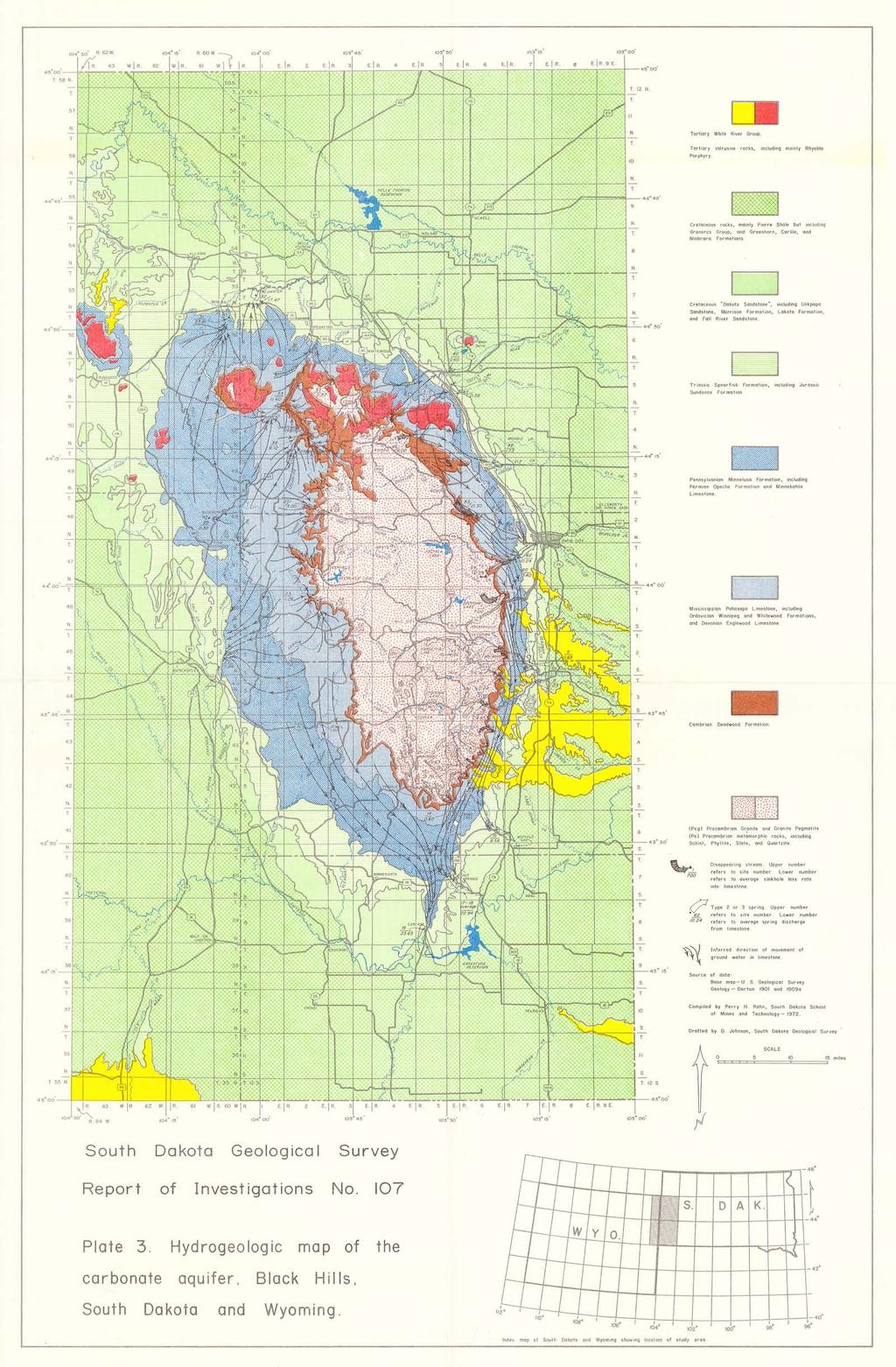
1 s. Oak. of No. /07 by Oak. Per r y H. Rahn and J. School of Mines and Rapid City, S. Oak. P. Gries Technology in cooperation with the Water Resources Research Institute under Project No. A-O2/- SOAK S. Oak. State University Brooklngs, S., S. Oak. Vermillion, S. Oak, Survey
2
3
4
5


 is the main object of this study, because all large springs are related to this aquifer. HYDROLOGY General precipitation and runoff characteristics of the Black Hills are described by Orr (1959).")
6 a. ;-- -;;, -.,:;;.. -'!.. "':I.,, /,"':/;::i;;'..:;" :;'if;l: :I,. :.,.c ""'. 'I c w.. -: ',I'..., 'o;;i".,;;,_: j' c '",fi'4..;.,.' -, J"--.,--' /. Figure 1. Cliffs of the Pahasapa Limestone, exposed in Spearfish Canyon. bedrock units, it is convenient to consider the rocks described above into five major groups. Cretaceous aquitard. The relatively impermeable Cretaceous black shales. b. Sandstone aquifer. Permeable Cretaceous and Jurassic Sandstones and interbedded shales. c. Triassic-Jurassic aquitard. The relatively impermeable Triassic Spearfish Formation and Jurassic Sundance Formation. d. Carbonate aquifer. Permeable Paleozoic limestones and sandy dolomites. e. Precambrian aquitard. Relatively impermeable lower Paleozoic Winnipeg and Deadwood Formations and the underlying Precambrian rocks. The carbonate aquifer (shown in blue, pl. 1) is the main object of this study, because all large springs are related to this aquifer. HYDROLOGY General precipitation and runoff characteristics of the Black Hills are described by Orr (1959). Average annual precipitation ranges from 26 inches in the high parts of the northern Hills to 16 inches in the lower elevations. Most of the precipitation occurs during the months from April to August. Streamflow records have been collected for many years, by the U.S. Geological Survey. These data are published in the Geological Survey's Water Supply Paper series for the streams of the Upper Missouri Basin. Some of these data have been incorporated into this report. Because the U.S. Geological Survey is mainly concerned with the discharge of major rivers, it was necessary for the purpose of this report to make many additional measurements of springs and streams above and below sinkholes. Streamflow is generally highest during April through July when precipitation is also highest. Another source of streamflow is the many small seeps and springs in the central Precambrian core. These normally freeze in winter, build ice accumulations, and melt in the spring. 3 -


 where the discharge exceeded 2 cfs, or with 3-inch Parshall flumes where the discharge was less than 2 cfs.")


7 Figure 2. Beaver Creek at Buffalo Gap (Site 15) is being gaged with the pigmy current meter. Twenty readings of the average velocity, as determined by a spinning wheel in the current, is multiplied by the cross-sectional area to determine the total discharge. STREAM GAGING PROCEDURE In order to understand the hydrology of the Paleozoic carbonate aquifer. it is necessary to measure the streamflow loss into it as well as the spring discharge from it. This is why there is a clustering of gaging stations oh or near the carbonate aquifer as shown on plate 1. A total of 63 different gaging stations were gaged periodically in this investigation. These stations are located on plate 1 and described in detail in appendix A. Gagings were measured with the Gurley pigmy current meter (fig. 2) where the discharge exceeded 2 cfs, or with 3-inch Parshall flumes where the discharge was less than 2 cfs. These techniques are discussed by Corbett (1962). In general, gagings were taken at each site once each month for as long as 4 years, but many of the less significant sites have less gagings. It is believed that one gaging each month gives an accurate indication of the discharge of a spring, because most springs have either a constant or only slightly variable discharge that follows a yearly cycle. For instance, if the average flow of the spring-fed Fall River, as determined by the continuous recordings of the U.S. Geological Survey Gaging Station is compared to monthly data, there is a difference of only 2 percent. Information derived from the monthly discharge measurements of streams draining the Precambrian core of the Black Hills is not as accurate as the spring measurements. The reason is that the Precambrian streams are subject to flooding after heavy rain or snowmelt (fig. 3). For example, there is a 17 percent error between the monthly gaging data and the U.S. Geological Survey Gaging Station data on Grace Coolidge Creek at Custer Park Zoo between October 1968 and January Because of the variable discharge of the Precambrian streams, they were gaged during a normal streamflow day during the month rather than during an exceptionally high or low streamflow day. -4-
8
9
 l4j c::.- 0 01 c:: 3: 0..c:: cn.c: U> U - -:-= Q) :r: U> -0 U Q) C. CD C Q) Q) -0.")
10 c:: U) t)') c::.- L- a.. U) L- a '--' c E 't- 0 (/) Q) Co >. - Q) -Q)..Co Q)..c - \t ō (/) l4j c:: c:: 3: 0..c:: cn.c: U> U - -:-= Q) :r: U> -0 U Q) C. CD C Q) Q) -0..c..;:t Q) ::) 01 LL
 0 C\" c:: 0..c:: (/)..c u-q) U>.-:r: t..j \...: <n u Q).p:.. m 0 Q) Q).")
11 c:.- U) C' C.- L- a. U) 0 c:. Ē \f- 0 (/) Q) a. >- - Q) Q) L....c- Q)..c- '+- 0 c: 0') 0 C" c:: 0..c:: (/)..c u-q) U>.-:r: t..j \...: <n u Q).p:.. m 0 Q) Q).c LO Q) \- ::3 CJ') LL

 classification of springs based on discharge (table 1), none of the springs in the Black Hills are of first")
, Cascade Spring (23.65 cfs), Fall River (22.92 cfs), the sum of the springs on Spearfish Creek (39.83 cfs), McNenny Fish Hatchery (17.")

 by D. W. Niven, a graduate student at South Dakota School of Mines and Technology.")

12 Figure 6. Boxelder Creek disappearing into the alluvium overlying sinkholes in the Pahasapa Limestone just below Site 53. Note whirlpool. small springs are too numerous to describe in this report; however, they form an important source of water for ranchers. Plate 2 shows the location and discharge of all three known types of major springs in the Black Hills. According to Meinzer's (1927) classification of springs based on discharge (table 1), none of the springs in the Black Hills are of first magnitude (discharge greater than 100 cfs). However, there are six second order springs having discharge between 10 to 100 cfs: Sand Creek (23.91 cfs), Cascade Spring (23.65 cfs), Fall River (22.92 cfs), the sum of the springs on Spearfish Creek (39.83 cfs), McNenny Fish Hatchery (17.47 cfs), and Cleghorn Spring (10.24 cfs). Dye Tests Dye tests were used to determine the interconnection of sinkholes and springs. The five following tests are of significance in understanding the hydrogeology of the carbonate aquifer. November, 1966 On November 22, 1966, 10 gallons of 15 percent Rhodamine B dye were injected into a sinkhole 100 yards above School Section Bridge (Site 53) by D. W. Niven, a graduate student at South Dakota School of Mines and Technology. Because a high rate of water movement was not anticipated, the springs downstream were not monitored until long after the crest of the dye flood had passed. Traces of the dye were detected from packets of activated charcoal which had been inserted in the springs beforehand. Table 1. Meinzer's (1927) classification of springs Magnitude First Second Third Fourth Fifth Sixth Average Discharge 100 cfs or greater 10 to 100 cfs 1 to 10 cfs to 1 cfs to cfs to cfs -9-
 0 \"C.- U co co on E co... U 0 u. oc c:.- on o't.-co Q) a. Ot/) -J\"C.c: r-. co Q) Q) c: 0 = C1on.-Q) u.")
13 co oc co Q) c: c: Q) oc 0 ti CO c: 0 u Q) oc co Q) C1... co oc :c 0 on c: '0 a. Q) co u :c.:: 0... c, c:.;: a. t/). c: Q) 0 "C.- U co co on E co... U 0 u. oc c:.- on o't.-co Q) a. Ot/) -J"C.c: r-. co Q) Q) c: 0 = C1on.-Q) u. E :J -10-
 injected 1 pound of fluorescein dye in 2Y2 gallons of water into the same sinkhole (fig. 8).")

.")
 three hours and two minutes after the original injection at the sinkhole.")
 six hours and thirty-five minutes after the original injection.")
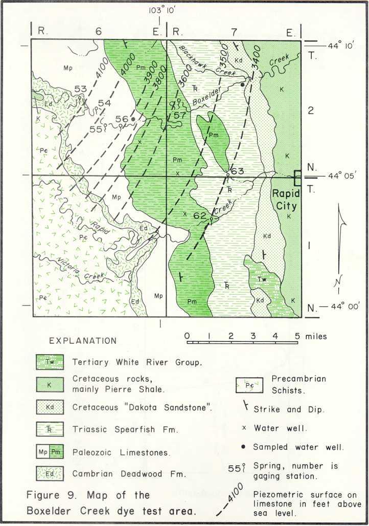
14 Figure 8. Dumping dye into the sinkhole in the Pahasapa Limestone along Boxelder Creek. April, 1968 July, 1968 On April 11, 1968, Crooks (1968, 1968b) injected 1 pound of fluorescein dye in 2Y2 gallons of water into the same sinkhole (fig. 8). One hour and eight minutes later visible dye suddenly appeared at Gravel Spring (Site 54). Since the airline distance between two points is 2,200 feet, the water moved through the Pahasapa Limestone at greater than 0.37 miles per hour! The water undoubtedly travels as an underground stream along a large crack, probably following a joint and/or bedding plane. Such avenues of ground-water movement are easily visible in the many caves in the Pahasapa Limestone (Gries, 1938; Conn, 1966). Most of the water from Gravel Spring usually sinks back into the limestone within a few hundred yards. Visible dye showed up at Doty Spring (Site 55) three hours and two minutes after the original injection at the sinkhole. At this time the small trickle of surface overflow from Gravel Spring had not yet reached Doty Spring. A much diluted fluorescence was noted at Dome Spring (Site 56) six hours and thirty-five minutes after the original injection. On July 9, 1968, the above test was repeated, using 1 gallon of red Rhodamine WT dye. The dye was injected in the same sinkhole, and reappeared at Gravel Spring in one hour and seven minutes. It showed at Doty Spring in two hours and fifty minutes, and at Dome Spring six hours and twenty-five minutes after the original injection. These three dye tests prove that the Boxelder Springs are directly related to Boxelder Creek where it disappears into the sinkholes. It should be pointed out that these springs are all Type 1 springs. and all lie in the same drainage basin as the disappearing master stream that feeds them. November, 1968 There is no Type 2 spring on Boxelder Creek. The lowermost spring on Boxelder Creek is Lang Spring (Site 57) which sinks back into the limestone. The question of the final destination of Boxelder Creek water remains unanswered. 11 -
15
16
17
18
,.")
 \"'C 0 E \ j")
 \... t).")
19 ,'"'" I; \, I 'I ""1,,.! U).- I uc I <.',,.. <t),. i, 1--1 '/ \ ft. \.,..,.'" Q;:: T1 CD -Q).r::. 0 '+- - Q) "'C 0 E \ j 't--. :.. -::: Q.) ct \ \ :..,' Q) \... t).c:: (/) '" - c Q) c: Q) <.9
20
21
22
23
24
25
26
27
28
29
30
31
32
33
34
35
36
37
38
39
40
41
42
43
44
45
46
47
48
49
50
51
52
53
54
PRECAMBRIAN CRYSTALLINE AQUIFER (METAMORPHIC ROCKS)
") HAYWARD QUADRANGLE: Groundwater Production by Aquifer In the 56-square-mile area of the Hayward Quadrangle, groundwater is produced from metamorphic crystalline rocks of the Precambrian basement (in the
HAYWARD QUADRANGLE: Groundwater Production by Aquifer In the 56-square-mile area of the Hayward Quadrangle, groundwater is produced from metamorphic crystalline rocks of the Precambrian basement (in the
PH YSIC A L PROPERT IE S TERC.UCDAVIS.EDU
 PH YSIC A L PROPERT IE S 8 Lake surface level Daily since 1900 Lake surface level varies throughout the year. Lake level rises due to high stream inflow, groundwater inflow and precipitation directly onto
QUANTITY, MARCH 1962
 BASE-FLOW STUDIES, GUADALUPE RIVER COMAL COUNTY, TEXAS QUANTITY, MARCH 1962 TEXAS WATER COMMISSION BULLETIN 6503 MARCH 1965 TEXAS WATER COMMISSION Joe William D E 0. F. Dent Carter, Chairman Berger, Commissioner
OVERVIEW AND RESULTS OF THE BLACK HILLS HYDROLOGY STUDY
 Proceedings of the South Dakota Academy of Science, Vol. 83 (2004) 149 OVERVIEW AND RESULTS OF THE BLACK HILLS HYDROLOGY STUDY Daniel G. Driscoll and Janet M. Carter U.S. Geological Survey Rapid City,
FRACTURE TRACES AND PRODUCTIVITY OF MUNICIPAL WELLS IN THE MADISON LIMESTONE, RAPID CITY, SOUTH DAKOTA
 Proceedings of the South Dakota Academy of Science, Vol. 87 (2008) 261 FRACTURE TRACES AND PRODUCTIVITY OF MUNICIPAL WELLS IN THE MADISON LIMESTONE, RAPID CITY, SOUTH DAKOTA Perry H. Rahn Department of
11/22/2010. Groundwater in Unconsolidated Deposits. Alluvial (fluvial) deposits. - consist of gravel, sand, silt and clay
 deposits. - consist of gravel, sand, silt and clay") Groundwater in Unconsolidated Deposits Alluvial (fluvial) deposits - consist of gravel, sand, silt and clay - laid down by physical processes in rivers and flood plains - major sources for water supplies
Groundwater in Unconsolidated Deposits Alluvial (fluvial) deposits - consist of gravel, sand, silt and clay - laid down by physical processes in rivers and flood plains - major sources for water supplies
Sediment Deposition LET THE RIVER RUN T E A C H E R. Activity Overview. Activity at a Glance. Time Required. Level of Complexity.
 Activity at a Glance Grade: 6 9 Subject: Science Category: Physical Science, Earth Science Topic: Deposition, River Systems Time Required Two 45-minute periods Level of Complexity Medium Materials* TI-73
PHYSICAL PROPERTIES TAHOE.UCDAVIS.EDU 8
 PHYSICAL PROPERTIES 8 Lake surface level Daily since 1900 Lake surface level varies throughout the year. Lake level rises due to high stream inflow, groundwater inflow, and precipitation directly onto
 12 10 8 6 4 2 0 40-50 50-60 60-70 70-80 80-90 90-100 Fresh Water What we will cover The Hydrologic Cycle River systems Floods Groundwater Caves and Karst Topography Hot springs Distribution of water in
Florida s Karst Geology
 Florida s Karst Geology Orange Creek Basin Interagency Working Group Public Workshop, November 5 th, 2015 Harley Means, P.G. Assistant State Geologist Florida Geological Survey Karst Karst a type of topography
 http://dx.doi.org/10/1061/40698(2003)19 Green, J., Pavlish, J., Leete, J., and Alexander, Jr., E. (2003) Quarrying Impacts on Groundwater Flow Paths. Sinkholes and the Engineering and Environmental Impacts
Groundwater. (x 1000 km 3 /y) Reservoirs. Oceans Cover >70% of Surface. Groundwater and the. Hydrologic Cycle
 Reservoirs. Oceans Cover >70% of Surface. Groundwater and the. Hydrologic Cycle") Chapter 13 Oceans Cover >70% of Surface Groundwater and the Hydrologic Cycle Oceans are only 0.025% of Mass Groundwater Groundwater is liquid water that lies in the subsurface in fractures in rocks and
Chapter 13 Oceans Cover >70% of Surface Groundwater and the Hydrologic Cycle Oceans are only 0.025% of Mass Groundwater Groundwater is liquid water that lies in the subsurface in fractures in rocks and
APPENDIX 3B OCCURRENCE OF SIGNIFICANT RIVER ALLUVIUM AQUIFERS IN THE PLATEAU REGION
 Plateau Region Water Plan January 2011 APPENDIX 3B OCCURRENCE OF SIGNIFICANT RIVER ALLUVIUM AQUIFERS IN THE PLATEAU REGION Occurrence of Significant River Alluvium Aquifers in the Plateau Region Prepared
Wisconsin s Hydrogeology: an overview
 2012 Soil and Water Conservation Society Conference Stevens Point, WI Feb 9, 2012 Wisconsin s Hydrogeology: an overview Ken Bradbury Wisconsin Geological and Natural History Survey University of Wisconsin-Extension
Groundwater Resources of Missouri. Cynthia Brookshire, R. G.
 Groundwater Resources of Missouri Cynthia Brookshire, R. G. GROUNDWATER... Water beneath the Earth s surface within a zone of saturation AQUIFER... A geologic formation or group of formations that are
Which map shows the stream drainage pattern that most likely formed on the surface of this volcano? A) B)
 B)") 1. When snow cover on the land melts, the water will most likely become surface runoff if the land surface is A) frozen B) porous C) grass covered D) unconsolidated gravel Base your answers to questions
1. When snow cover on the land melts, the water will most likely become surface runoff if the land surface is A) frozen B) porous C) grass covered D) unconsolidated gravel Base your answers to questions
WATER ON AND UNDER GROUND. Objectives. The Hydrologic Cycle
 WATER ON AND UNDER GROUND Objectives Define and describe the hydrologic cycle. Identify the basic characteristics of streams. Define drainage basin. Describe how floods occur and what factors may make
Hydrogeology of Karst NE Wisconsin. Dr. Maureen A. Muldoon UW-Oshkosh Geology Department
 Hydrogeology of Karst NE Wisconsin Dr. Maureen A. Muldoon UW-Oshkosh Geology Department WI Bedrock Outline Karst Landscapes Existing WQ Data Flow in Karst Aquifers Overview of Silurian Aquifer Water Level
Each basin is surrounded & defined by a drainage divide (high point from which water flows away) Channel initiation
 Channel initiation") DRAINAGE BASINS A drainage basin or watershed is defined from a downstream point, working upstream, to include all of the hillslope & channel areas which drain to that point Each basin is surrounded &
DRAINAGE BASINS A drainage basin or watershed is defined from a downstream point, working upstream, to include all of the hillslope & channel areas which drain to that point Each basin is surrounded &
American Institute of Professional Geologists South Dakota Section
 American Institute of Professional Geologists South Dakota Section 2015 Field Trip Guide Deadwood Formation in the Black Hills of South Dakota and Frac Sand Potential Saturday, September 12, 2015 1 Field
Karst Sub-basin Delineation via Dye Trace Study near Turnhole Bend, Mammoth Cave National Park
 Western Michigan University ScholarWorks at WMU Honors Theses Lee Honors College 4-18-2017 Karst Sub-basin Delineation via Dye Trace Study near Turnhole Bend, Mammoth Cave National Park Jake Tholen Western
Earth Science Chapter 9. Day 6 - Finish Capillary Action Lab - Quiz over Notes - Review Worksheets over Sections 9.2 and 9.3
 Earth Science Chapter 9 Day 1 Day 2 Day 3 Read Section 9.1 Surface Water Chapter 9 Term Sheet Notes over Section 9.1 Surface Water Section 9.1 Review Worksheets Quiz over Section 9.1 Notes Virtual Lab
REDWOOD VALLEY SUBAREA
 Independent Science Review Panel Conceptual Model of Watershed Hydrology, Surface Water and Groundwater Interactions and Stream Ecology for the Russian River Watershed Appendices A-1 APPENDIX A A-2 REDWOOD
What we will cover. The Hydrologic Cycle. River systems. Floods. Groundwater. Caves and Karst Topography. Hot springs
 Fresh Water What we will cover The Hydrologic Cycle River systems Floods Groundwater Caves and Karst Topography Hot springs On a piece of paper, put these reservoirs of water in to order from largest to
Lower Tuolumne River Accretion (La Grange to Modesto) Estimated daily flows ( ) for the Operations Model Don Pedro Project Relicensing
 Estimated daily flows ( ) for the Operations Model Don Pedro Project Relicensing") Lower Tuolumne River Accretion (La Grange to Modesto) Estimated daily flows (1970-2010) for the Operations Model Don Pedro Project Relicensing 1.0 Objective Using available data, develop a daily time series
Lower Tuolumne River Accretion (La Grange to Modesto) Estimated daily flows (1970-2010) for the Operations Model Don Pedro Project Relicensing 1.0 Objective Using available data, develop a daily time series
N. J. Macala. C ONTENT S. LIST OF PLATES.
 REPORT ON WATER SUikLY AT MANBULLOO STATION, NORTHERN TERRITORY. by N. J. Macala. Records 1957/62. C ONTENT S. Page. Introduction. 1. General Geology, 1. Hydrology. 1. New Bore Sites Selected. 2. Reference.
Natural Variability in Annual Maximum Water Level and Outflow of Yellowstone Lake
 Natural Variability in Annual Maximum Water Level and Outflow of Yellowstone Lake Phillip E. Farnes Abstract The water level in Yellowstone Lake varies each year in response to differences in the winter
RR#5 - Free Response
 Base your answers to questions 1 through 3 on the data table below and on your knowledge of Earth Science. The table shows the area, in million square kilometers, of the Arctic Ocean covered by ice from
Soils, Hydrogeology, and Aquifer Properties. Philip B. Bedient 2006 Rice University
 Soils, Hydrogeology, and Aquifer Properties Philip B. Bedient 2006 Rice University Charbeneau, 2000. Basin Hydrologic Cycle Global Water Supply Distribution 3% of earth s water is fresh - 97% oceans 1%
9. PROBABLE MAXIMUM PRECIPITATION AND PROBABLE MAXIMUM FLOOD
 9. PROBABLE MAXIMUM PRECIPITATION AND PROBABLE MAXIMUM FLOOD 9.1. Introduction Due to the size of Watana Dam and the economic importance of the Project to the Railbelt, the Probable Maximum Flood (PMF)
6.1 Water. The Water Cycle
 6.1 Water The Water Cycle Water constantly moves among the oceans, the atmosphere, the solid Earth, and the biosphere. This unending circulation of Earth s water supply is the water cycle. The Water Cycle
Prentice Hall EARTH SCIENCE
 Prentice Hall EARTH SCIENCE Tarbuck Lutgens Running Water and Groundwater Running Water The Water Cycle Water constantly moves among the oceans, the atmosphere, the solid Earth, and the biosphere. This
LBJWC - Sinkhole Lesson
 LBJWC - Sinkhole Lesson Concept Caves and sinkholes are major openings in the ground that recharge water to the Edwards Aquifer. Objective - Students will: 1) identify a sinkhole, cave, fracture, fault,
Lecture Outlines PowerPoint. Chapter 5 Earth Science 11e Tarbuck/Lutgens
 Lecture Outlines PowerPoint Chapter 5 Earth Science 11e Tarbuck/Lutgens 2006 Pearson Prentice Hall This work is protected by United States copyright laws and is provided solely for the use of instructors
Dye Trace Report on Campbell Valley Creek
 Dye Trace Report on Campbell Valley Creek Housn and Winona Counties, Minnesota 2012-2013 John D. Barry 1, Jeffrey A. Green 1, Kelsi R. Ustipak 2, Betty Wheeler 2, and E. Calvin Alexander, Jr. 2 1 Minnesota
What do Gollum and Batman have in common?
 What do Gollum and Batman have in common? http://www.freewebs.com/footballthoughts/gollum.png http://i.livescience.com/images/batcave-companion-02.jpg They both live in Karst! umm What s a Karst? Karst
2. PHYSICAL SETTING FINAL GROUNDWATER MANAGEMENT PLAN. 2.1 Topography. 2.2 Climate
 FINAL GROUNDWATER MANAGEMENT PLAN 2. PHYSICAL SETTING Lassen County is a topographically diverse area at the confluence of the Cascade Range, Modoc Plateau, Sierra Nevada and Basin and Range geologic provinces.
Michigan s Geology and Groundwater
 Michigan s Geology and Groundwater Ralph J. Haefner Deputy Director U.S. Geological Survey Michigan-Ohio Water Science Center Lansing, Michigan Outline About the USGS Geology 101 Michigan s geology Bedrock
January 2011 Calendar Year Runoff Forecast
 January 2011 Calendar Year Runoff Forecast 2010 Runoff Year Calendar Year 2010 was the third highest year of runoff in the Missouri River Basin above Sioux City with 38.8 MAF, behind 1978 and 1997 which
Chapter 5 CALIBRATION AND VERIFICATION
 Chapter 5 CALIBRATION AND VERIFICATION This chapter contains the calibration procedure and data used for the LSC existing conditions model. The goal of the calibration effort was to develop a hydraulic
2015 Fall Conditions Report
 2015 Fall Conditions Report Prepared by: Hydrologic Forecast Centre Date: December 21 st, 2015 Table of Contents Table of Figures... ii EXECUTIVE SUMMARY... 1 BACKGROUND... 2 SUMMER AND FALL PRECIPITATION...
KANSAS GEOLOGICAL SURVEY Open File Report LAND SUBSIDENCE KIOWA COUNTY, KANSAS. May 2, 2007
 KANSAS GEOLOGICAL SURVEY Open File Report 2007-22 LAND SUBSIDENCE KIOWA COUNTY, KANSAS Prepared by Michael T. Dealy L.G., Manager, Wichita Operations SITE LOCATION The site was approximately four miles
Description DESCRIPTION
 DESCRIPTION The location of the Upper James Watershed is located in northeastern South Dakota as well as southeastern North Dakota. It includes the following counties located in North Dakota Barnes, Dickey,
NATURALLY OCCURRING ACID ROCK DRAINAGE AND IMPACTS TO THE UPPER RAPID CREEK WATERSHED NEAR ROCHFORD, SD
 Proceedings of the South Dakota Academy of Science, Vol. 83 (2004) 83 NATURALLY OCCURRING ACID ROCK DRAINAGE AND IMPACTS TO THE UPPER RAPID CREEK WATERSHED NEAR ROCHFORD, SD Scott L. Miller and Arden D.
What do Gollum and Batman have in common?
 What do Gollum and Batman have in common? http://www.freewebs.com/footballthoughts/gollum.png http://i.livescience.com/images/batcave-companion-02.jpg They both live in Karst! umm What s a Karst? Karst
JOURNAL OF ENVIRONMENTAL HYDROLOGY
 JOURNAL OF ENVIRONMENTAL HYDROLOGY The Electronic Journal of the International Association for Environmental Hydrology On the World Wide Web at http://www.hydroweb.com VOLUME 13 2005 THE EFFECT OF SINKHOLES
Karst Topography In order to understand karst topography we must first have a basic understanding of the water cycle, the formation of limestone (carb
 Karst Topography The formation of caves and other associated features in limestone bedrock is called karst topography. Limestone, a sedimentary rock made mostly of the mineral calcite and small amounts
Lecture 15: Subsidence
 Lecture 15: Subsidence Key Questions 1. How does removal of groundwater cause subsidence on a regional scale? 2. Under what conditions does a building sink into sediment? 3. Why do clays consolidate more
PRELIMINARY DRAFT FOR DISCUSSION PURPOSES
 Memorandum To: David Thompson From: John Haapala CC: Dan McDonald Bob Montgomery Date: February 24, 2003 File #: 1003551 Re: Lake Wenatchee Historic Water Levels, Operation Model, and Flood Operation This
the Quarrying Industry Dewatering and the Quarrying Industry the Quarrying Industry
 Dewatering and the Quarrying Industry Dewatering and Dewatering and the Quarrying Industry the Quarrying Industry Les Brown Eugene P. Daly John Kelly Objectives 1) To present a summary of water management
Stream Discharge and the Water Budget
 Regents Earth Science Unit 6: Water Cycle & Climate Name: Lab # Stream Discharge and the Water Budget Introduction: The United States Geological Survey (USGS) measures and publishes values for the daily
STUDY GUIDE FOR CONTENT MASTERY. Surface Water Movement
 Surface Water SECTION 9.1 Surface Water Movement In your textbook, read about surface water and the way in which it moves sediment. Complete each statement. 1. An excessive amount of water flowing downslope
Great Lakes Update. Volume 194: 2015 Annual Summary
 Great Lakes Update Volume 194: 2015 Annual Summary Background The U.S. Army Corps of Engineers (USACE) tracks and forecasts the water levels of each of the Great Lakes. This report summarizes the hydrologic
HyMet Company. Streamflow and Energy Generation Forecasting Model Columbia River Basin
 HyMet Company Streamflow and Energy Generation Forecasting Model Columbia River Basin HyMet Inc. Courthouse Square 19001 Vashon Hwy SW Suite 201 Vashon Island, WA 98070 Phone: 206-463-1610 Columbia River
HYDROLOGIC AND WATER RESOURCES EVALUATIONS FOR SG. LUI WATERSHED
 HYDROLOGIC AND WATER RESOURCES EVALUATIONS FOR SG. LUI WATERSHED 1.0 Introduction The Sg. Lui watershed is the upper part of Langat River Basin, in the state of Selangor which located approximately 20
STUDY GUIDE FOR CONTENT MASTERY. Movement and Storage of Groundwater
 Groundwater SECTION 10.1 Movement and Storage of Groundwater In your textbook, read about the hydrosphere, precipitation and groundwater, and groundwater storage. Use the following terms to complete the
Groundwater. (x 1000 km 3 /y) Oceans Cover >70% of Surface. Groundwater and the. Hydrologic Cycle
 Oceans Cover >70% of Surface. Groundwater and the. Hydrologic Cycle") Chapter 17 Oceans Cover >70% of Surface Groundwater and the Hydrologic Cycle Vasey s Paradise, GCNP Oceans are only 0.025% of Mass Groundwater Groundwater is liquid water that lies in the subsurface in
Chapter 17 Oceans Cover >70% of Surface Groundwater and the Hydrologic Cycle Vasey s Paradise, GCNP Oceans are only 0.025% of Mass Groundwater Groundwater is liquid water that lies in the subsurface in
Groundwater Hydrology
 EXERCISE 12 Groundwater Hydrology INTRODUCTION Groundwater is an important component of the hydrologic cycle. It feeds lakes, rivers, wetlands, and reservoirs; it supplies water for domestic, municipal,
Freshwater. 1. The diagram below is a cross-sectional view of rain falling on a farm field and then moving to the water table.
 Name: ate: 1. The diagram below is a cross-sectional view of rain falling on a farm field and then moving to the water table. 3. Which conditions produce the most surface water runoff? A. steep slope,
Accepted for publication by Kentucky Section of the American Institute of Professional Geologists
 August 25, 2016 Relationships between surface and ground water velocities determined from dye trace experiments in McConnell Springs and Preston s Cave Spring, Lexington, Fayette County, Kentucky Laura
Hydrogeology and Simulated Effects of Future Water Use and Drought in the North Fork Red River Alluvial Aquifer: Progress Report
 Hydrogeology and Simulated Effects of Future Water Use and Drought in the North Fork Red River Alluvial Aquifer: Progress Report Developed in partnership with the Oklahoma Water Resources Board S. Jerrod
Field Observations and One-Dimensional Flow Modeling of Summit Creek in Mack Park, Smithfield, Utah
 Intermountain Center for River Rehabilitation and Restoration, Utah State University 31 July 2018 Field Observations and One-Dimensional Flow Modeling of Summit Creek in Mack Park, Smithfield, Utah I.
L-31N Seepage Management Field Test
 Miami-Dade Limestone Products Association 13292 N.W. 118 th Avenue Miami, FL 33178 L-31N Seepage Management Field Test The Performance of a Partially Penetrating Seepage Barrier along the L-31N Canal July
https://gsa.confex.com/gsa/2014am/webprogram/paper html
 Abstract: IMPACT OF PALEOZOIC KARST UPON GROUNDWATER FLOW IN TH... https://gsa.confex.com/gsa/2014am/webprogram/paper244571.html Page 1 of 1 28/08/2014 Start Author Index Meeting Information Paper No.
Hydrologic Forecast Centre Manitoba Infrastructure, Winnipeg, Manitoba. FEBRUARY OUTLOOK REPORT FOR MANITOBA February 23, 2018
 Page 1 of 17 Hydrologic Forecast Centre Manitoba Infrastructure, Winnipeg, Manitoba FEBRUARY OUTLOOK REPORT FOR MANITOBA February 23, 2018 Overview The February Outlook Report prepared by the Hydrologic
Great Lakes Update. Volume 199: 2017 Annual Summary. Background
 Great Lakes Update Volume 199: 2017 Annual Summary Background The U.S. Army Corps of Engineers (USACE) tracks and forecasts the water levels of each of the Great Lakes. This report is primarily focused
HYDROGEOLOGY OF THE HOMESTAKE MINE
 Proceedings of the South Dakota Academy of Science, Vol. 81 (2002) 19 HYDROGEOLOGY OF THE HOMESTAKE MINE Perry H. Rahn and William M. Roggenthen Department of Geology and Geological Engineering South Dakota
1. The map below shows a meandering river. A A' is the location of a cross section. The arrows show the direction of the river flow.
 1. The map below shows a meandering river. A A' is the location of a cross section. The arrows show the direction of the river flow. Which cross section best represents the shape of the river bottom at
UGRC 144 Science and Technology in Our Lives/Geohazards
 UGRC 144 Science and Technology in Our Lives/Geohazards Flood and Flood Hazards Dr. Patrick Asamoah Sakyi Department of Earth Science, UG, Legon College of Education School of Continuing and Distance Education
Today I will describe the groundwater/surface water interaction in the CRB in Mosier basin.
 Today I will describe the groundwater/surface water interaction in the CRB in Mosier basin. 1 Ken Lite, studying groundwater resource in Mosier basin since 1980 s (photo by A. Bouchier) 2012 with Jonathan
2017 Fall Conditions Report
 2017 Fall Conditions Report Prepared by: Hydrologic Forecast Centre Date: November 15, 2017 Table of Contents TABLE OF FIGURES... ii EXECUTIVE SUMMARY... 1 BACKGROUND... 4 SUMMER AND FALL PRECIPITATION...
1 in = ft (round answer to nearest integer)
") Hydrology LAB 1: DRAINAGE-BASIN PROPERTIES AND SIMPLE METEOROLOGIC CALCULATIONS OBJECTIVES: a. to develop your ability to extract basic drainage-basin data from topographic maps b. to learn how to make
Hydrology LAB 1: DRAINAGE-BASIN PROPERTIES AND SIMPLE METEOROLOGIC CALCULATIONS OBJECTIVES: a. to develop your ability to extract basic drainage-basin data from topographic maps b. to learn how to make
HW #2 Landscape Travel from A to B 12,
 HW #2 Landscape 2016 Section: Name: ate: 1. ase your answer(s) to the following question(s) on the map below, which represents two bridges that cross the Green River. Letters,, and represent locations
Name. 4. The diagram below shows a soil profile formed in an area of granite bedrock. Four different soil horizons, A, B, C, and D, are shown.
 Name 1. In the cross section of the hill shown below, which rock units are probably most resistant to weathering? 4. The diagram below shows a soil profile formed in an area of granite bedrock. Four different
Unit 7.2 W.E.D. & Topography Test
 Name: Score: Unit 7.2 W.E.D. & Topography Test 1. 2. 3. 4. 5. 6. 7. 8. 9. 10. 11. 12. 13. 14. 15. 16. 17. 18. 19. 20. 21. 22. 23. 24. 25. 1. The formation of mountains is due mainly to while the destruction
Essentials of Geology, 11e
 Essentials of Geology, 11e Groundwater Chapter 10 Instructor Jennifer Barson Spokane Falls Community College Geology 101 Stanley Hatfield Southwestern Illinois Co Jennifer Cole Northeastern University
Geology (Mellow) Hike, Santa Lucia Memorial Park February 16, I. Overview of Santa Lucia Range geology and tectonic history
 Hike, Santa Lucia Memorial Park February 16, I. Overview of Santa Lucia Range geology and tectonic history") Geology (Mellow) Hike, Santa Lucia Memorial Park February 16, 2015 I. Overview of Santa Lucia Range geology and tectonic history A. Basement Rocks 1. Salinian Block Rocks Sierra Nevada Type, continental
Geology (Mellow) Hike, Santa Lucia Memorial Park February 16, 2015 I. Overview of Santa Lucia Range geology and tectonic history A. Basement Rocks 1. Salinian Block Rocks Sierra Nevada Type, continental
Rivers and Streams. Streams. Hydrologic Cycle. Drainage Basins and Divides. Colorado River Drainage Basin. Colorado Drainage Basins.
 Chapter 14 Hydrologic Cycle Rivers and Streams Streams A stream is a body of water that is confined in a channel and moves downhill under the influence of gravity. This definition includes all sizes of
 http://water.usgs.gov/waterwatch/ Stream Flow Measurement: Velocity-Area method Stream discharge = Q = U * A Q = volumetric flow rate in [L 3 T -1 ] U= average stream velocity [L 2 T -1 ] A = cross sectional
3.0 TECHNICAL FEASIBILITY
 3.0 TECHNICAL FEASIBILITY 3.1 INTRODUCTION To enable seasonal storage and release of water from Lake Wenatchee, an impoundment structure would need to be constructed on the lake outlet channel. The structure
Great Lakes Update. Volume 193: 2015 January through June Summary. Vol. 193 Great Lakes Update August 2015
 Great Lakes Update Volume 193: 2015 January through June Summary The U.S. Army Corps of Engineers (USACE) monitors the water levels of each of the Great Lakes. This report provides a summary of the Great
Chapter 8 Fetter, Applied Hydrology 4 th Edition, Geology of Groundwater Occurrence
 Chapter 8 Fetter, Applied Hydrology 4 th Edition, 2001 Geology of Groundwater Occurrence Figure 8.42. Alluvial Valleys ground-water region. Fetter, Applied Hydrology 4 th Edition, 2001 Fetter, Applied
Hydrologic Forecast Centre. Manitoba Infrastructure. Winnipeg, Manitoba FEBRUARY FLOOD OUTLOOK REPORT FOR MANITOBA.
 Page 1 of 20 Hydrologic Forecast Centre Manitoba Infrastructure Winnipeg, Manitoba FEBRUARY FLOOD OUTLOOK REPORT FOR MANITOBA February 28, 2019 Overview The February Outlook Report prepared by the Hydrologic
Squaw Creek. General Information
 General Information is a tributary to the Salmon River. It enters the north side of the river about 0 miles downstream of North Fork, Idaho. The study reach is about a 30 ft length of stream about 2 miles
Ontonagon River Assessment FIGURES
 FIGURES 95 Major Streams and Lakes 1 Pelton Creek 36 Imp Creek 2 Slate River 37 Imp Lake 3 Marshall Creek 38 Marion Lake 4 Trout Brook 39 Tamarack Lake 5 Lake Gogebic 40 Tamarack River 6 West Branch Ontonagon
USING GIS TO MODEL AND ANALYZE HISTORICAL FLOODING OF THE GUADALUPE RIVER NEAR NEW BRAUNFELS, TEXAS
 USING GIS TO MODEL AND ANALYZE HISTORICAL FLOODING OF THE GUADALUPE RIVER NEAR NEW BRAUNFELS, TEXAS ASHLEY EVANS While the state of Texas is well-known for flooding, the Guadalupe River Basin is one of
Mammoth Cave National Park, Kentucky
 Mammoth Cave National Park, Kentucky Objectives of Today s Lecture Refresher on Sedimentary Depositional Systems and Rock Classifications Transgressive and Regressive Marine Environments Carbonate Depositional
Applicability of Paleoflood Surveys to the Black Hills of Western South Dakota
 Connecting South Dakota and the Nation South Dakota Department of Transportation Office of Research SD2005-12X Applicability of Paleoflood Surveys to the Black Hills of Western South Dakota Study SD2005-12
Prof. Stephen A. Nelson EENS 111. Groundwater
 Page 1 of 8 Prof. Stephen A. Nelson EENS 111 Tulane University Physical Geology This page last updated on 20-Oct-2003 is water that exists in the pore spaces and fractures in rock and sediment beneath
Groundwater-Surface Water Interactions along the Hangman, California, and Rock Creeks, September 30, 2009
 Groundwater-Surface Water Interactions along the Hangman, California, and Rock Creeks, September 30, 2009 Abstract This data collection effort was required to complete recommendations in the Hangman Creek
Investigation IV: Seasonal Precipitation and Seasonal Surface Runoff in the US
 Investigation IV: Seasonal Precipitation and Seasonal Surface Runoff in the US Purpose Students will consider the seasonality of precipitation and surface runoff and think about how the time of year can
Hydrology and Hydraulics Design Report. Background Summary
 To: National Park Services Montezuma Castle National Monument Richard Goepfrich, Facility Manager From: Multicultural Technical Engineers Date: Tuesday - February 13, 2018 Subject: 30% Hydrology and Hydraulics
RIVERS, GROUNDWATER, AND GLACIERS
 RIVERS, GROUNDWATER, AND GLACIERS Delta A fan-shaped deposit that forms when a river flows into a quiet or large body of water, such as a lake, an ocean, or an inland sea. Alluvial Fan A sloping triangle
The hydrologic service area (HSA) for this office covers Central Kentucky and South Central Indiana.
 for this office covers Central Kentucky and South Central Indiana.") NWS Form E-5 (04-2006) NATIONAL OCEANIC AND ATMOSPHERIC ADMINISTRATION (PRES. BY NWS Instruction 10-924) NATIONAL WEATHER SERVICE MONTHLY REPORT OF HYDROLOGIC CONDITIONS HYDROLOGIC SERVICE AREA (HSA) Louisville
NWS Form E-5 (04-2006) NATIONAL OCEANIC AND ATMOSPHERIC ADMINISTRATION (PRES. BY NWS Instruction 10-924) NATIONAL WEATHER SERVICE MONTHLY REPORT OF HYDROLOGIC CONDITIONS HYDROLOGIC SERVICE AREA (HSA) Louisville
Last Updated HYDROLOGIC ATLAS OF THE BLACK HILLS, PENNINGTON COUNTY, SOUTH DAKOTA
 Last Updated 10-29-2015 HYDROLOGIC ATLAS OF THE BLACK HILLS, PENNINGTON COUNTY, SOUTH DAKOTA INTRODUCTION The following is a brief outline of ground water characteristics in Pennington County, South Dakota.
Great Lakes Update. Volume 191: 2014 January through June Summary. Vol. 191 Great Lakes Update August 2014
 Great Lakes Update Volume 191: 2014 January through June Summary The U.S. Army Corps of Engineers (USACE) monitors the water levels of each of the Great Lakes. This report provides a summary of the Great
FEMA Hazards Loss Modeling Task Force (MOTF) Situation Report #14. Colorado Spring Flood Risk ***FINAL REPORT***
 Situation Report #14. Colorado Spring Flood Risk ***FINAL REPORT***") FEMA Hazards Loss Modeling Task Force (MOTF) Situation Report #14 Colorado Spring Flood Risk FEMA Modeling Task Force (MOTF) Denver Federal Center, Building 710A Denver, Colorado 80225 Email: FEMA-MOTF@fema.dhs.gov
FEMA Hazards Loss Modeling Task Force (MOTF) Situation Report #14 Colorado Spring Flood Risk FEMA Modeling Task Force (MOTF) Denver Federal Center, Building 710A Denver, Colorado 80225 Email: FEMA-MOTF@fema.dhs.gov
PENNSYLVANIA DEPARTMENT OF TRANSPORTATION ENGINEERING DISTRICT 3-0
 PENNSYLVANIA DEPARTMENT OF TRANSPORTATION ENGINEERING DISTRICT 3-0 LYCOMING COUNTY S.R.15, SECTION C41 FINAL HYDROLOGIC AND HYDRAULIC REPORT STEAM VALLEY RUN STREAM RELOCATION DATE: June, 2006 REVISED:
The Climate of Oregon Climate Zone 4 Northern Cascades
 /05 E55 Unbound issue No. 9/ is Does not circulate Special Report 916 May 1993 The Climate of Oregon Climate Zone 4 Property of OREGON STATE UNIVERSITY Library Serials Corvallis, OR 97331-4503 Agricultural