PROJECT AREA CON LAKE. MAP No. G-22 - CASTLEWOOD LAKE AREA DISTRICT OF THUNDER BAY OP90-372
|
|
|
- Georgina Lane
- 6 years ago
- Views:
Transcription
1 42E13NE888I CASTLEWOOD LAKE 010 PROJECT AREA CON LAKE MAP No. G-22 - CASTLEWOOD LAKE AREA DISTRICT OF THUNDER BAY OP90-372
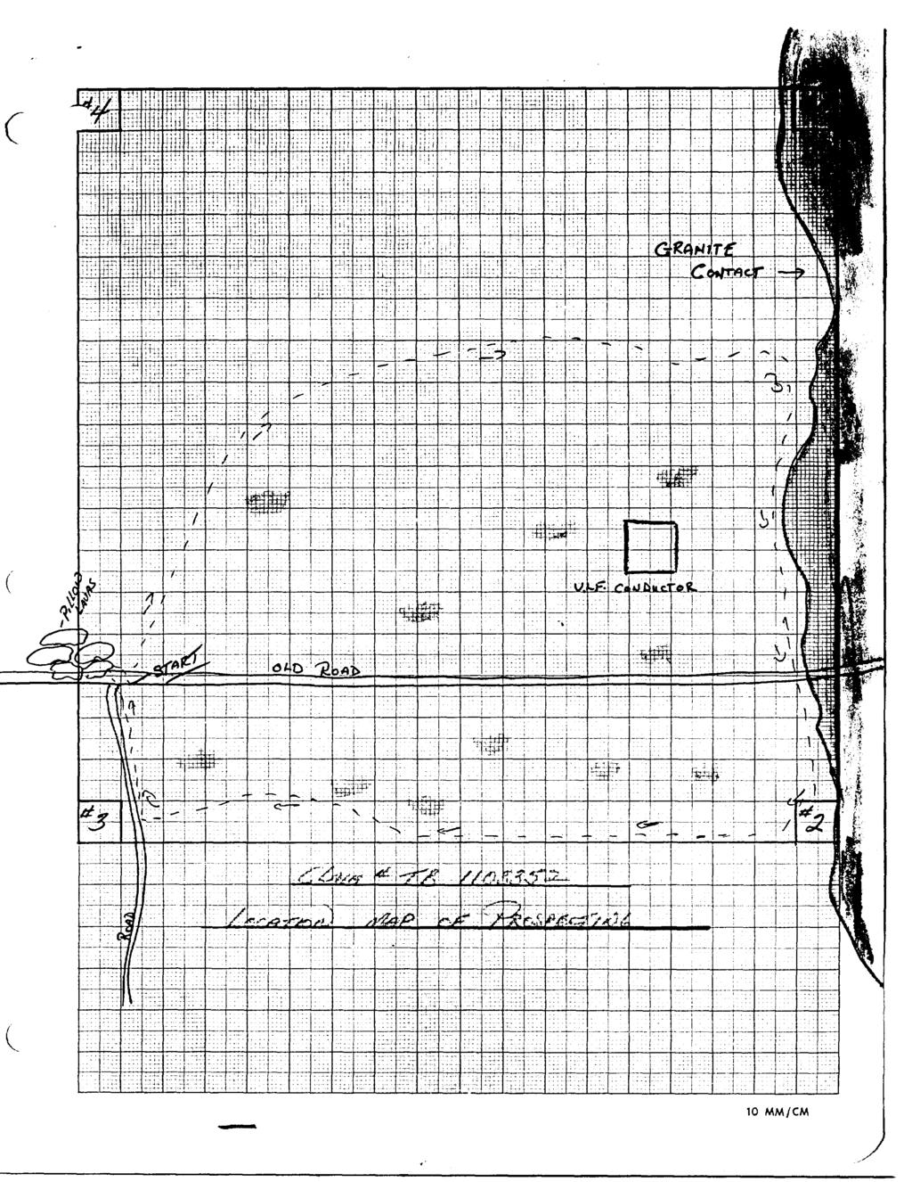
2 TECHNICAL REPORT FINAL SUBMISSION M. NELSON CLAIM BLOCK OP90-372
3 #1 TRENCH The #1 Trench was dug in low country and the backhoe had only taken a few bucketfulls when water problems were encountered. I feel that the little work that was done here is not worth recording. OP90-372
4 #2 Zone The #2 zone was found by prospecting and further traced using a Cat backhoe. This trench was dug 8 feet deep, 50 feet long and 15 feet wide. The mineral noted in the vein was pyrite, chalcopyrite and pyrrohotite. The host rock consisted of a very fine grained felsic unit in which numerous quartz viening occures. Pyrrohotite is the most abundant mineral, but in places pyrite is also quite heavy. The chalcopyrite is very finely disseminated and the minor quantity gave low assays. This zone was also assayed for gold but returned poor values. This unit is approximatly 12 feet wide and strikes east-west and is 500 feet south of No. l post. SILVER GOLD COPPER Trench # PPH PPM " " " " " " " OP90-372
5 #5 Zone The #3 zone is 15 feet west and 10 feet south of the #2 zone. This was found by using the excavator. The vein when exposed was four feet across and was covered with rust, After blasting the zone it turned out to be a blue-grey quartz with chlorite banding and fuchite. Very fine pyrite and chalcopyrite was scattered throughout the width of the vein. Three samples were taken from different areas. Although samples (1) and (3) were low, sample (2) returned a.0^-6 in gold. This also has an east-west strike and is 500 feet south of North Boundary and is 15 feet west of #2 trench. ' GOLD Number 3 Zone /tG OP90-372
6 #U Zone The #4 zone was found using the excavator. It is located 30 feet north of the #3 vein. It is striking in an east-west direction and is exposed for about 15 feet in length.the width of the vein is about 8 feet and is highly rusted. Only two holes were drilled in this so that it could be blasted for a good look. Here again the rock turned out to be a blue-grey quartz with fine pyrite, and minute amounts of chalcopyrite. Two grab samples were taken and although the results were low more work will have to be done to find the true width and length. The northern part of the zone had a lot of water seepage. This also strikes eastwest and is ^30 feet south of North Boundary line and 30 feet north of #3 trench. GOLD Number ^. Zone SI S OP90-372
7 #6 Zone This zone is about 540 feet south of North Boundary and is about 30 feet south of trench #5 and strikes east.and west. A two foot wide vein of rusty blue quartz with fine pyrite was found by using the excavator. This vein was followed for about 85 feet and did not amount to very much. A grab smaple was taken to see if it carried any values. I t is approximatly 120 feet west of #3 trench. GOLD No. 6 Zone SI OP90-272
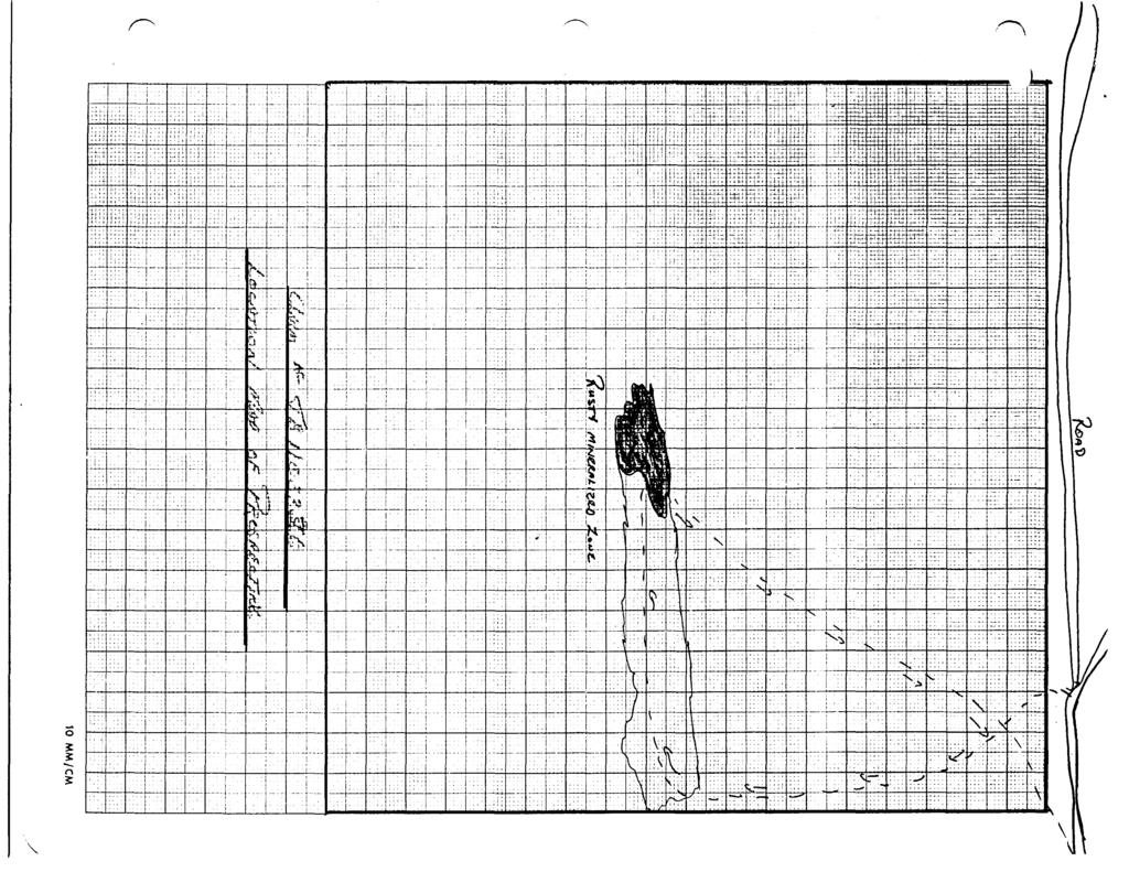
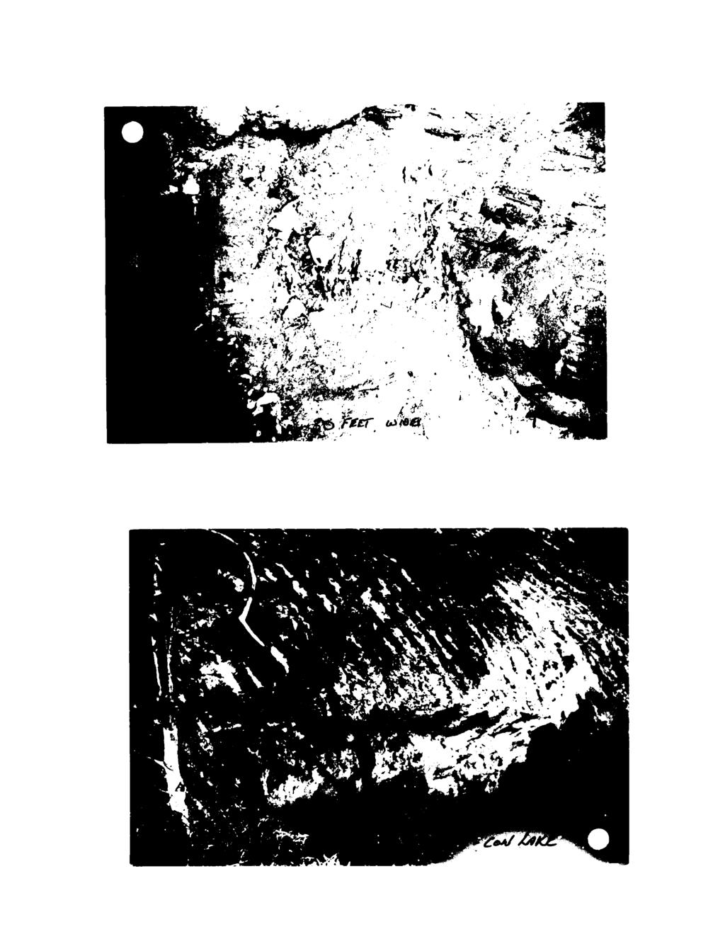
8 ZONES #5-#7-#8 Zones #5 j #7 and #8 are what I believe to be the same unit, although the three trenches are almost 100 feet apart. Also 250 feet to the east is the No. 3 zone and this also lines up with #5* #7 and #8. All three of these veins are covered with a heavy coating of Rust. All three were blasted into, and grab samples were taken. The material is again a blue-grey banded quartz with fine pyrite, chalcopyrite and fuchsite found in small amounts. The vein in number 5 trench is 5 feet wide. The same vein exposed in #7 trench is seven feet wide, and when exposed in #8 trench it is 30 feet wide- These three zones were found by using a Geonics EM16 - VLF and then digging with the backhoe. The strike is East-West. GOLD Trench #5 S1.010 S2.005 Trench #7 S3 TR Trench #8 SI TR. OP90-372
9 FINAL REPORT M. NELSON CLAIM BLOCK CON LAKE AREA OP90-372
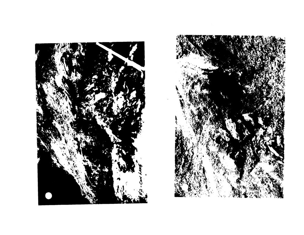
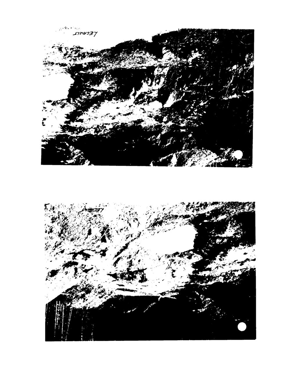
10 CON LAKE PROPERTY The G.P.A.P. grant was initially supposed to be used on a property in Legault Township. After doing a program on this ground last year (OP89-265) and turning up interest ing mineralized gold bearing zones, the ground was optioned to Freewest Resources of Montreal, (Please find pictures enclosed) and the 1990 O.P.A.P. grant was transferred to my claims on Con Lake in the Onamon Lake area. This ground was staked on March 12, 1989* A total of 12 claims are in the group and they are situated just west of mileage 55 of the Nipigon Provincial Boundary line. The areas to the north and to the south have seen a lot of mining activity since 1923 when gold was discovered by J. McKechnie. This find became the Taskota Goldmine. I started the program at the property on September 3) 1990 with V.L.F., work was done by MacAdam Explorations of Beardmore and the power trenching was done by Thorcox Excavating also of Beardmore.A total of seven trenches were dug ranging in a depth of one foot to twelve feet. Trench #2 was dug because of a rusty zone found on surface by conventional prospecting. All the other trenches were dug because of readings that were obtained by using the V.L.F. The showing in #2 trench contains pyrite, pyrrohotite and very fine chalcopyrite. This was assayed for copper, silver and gold but the results were not very encouraging. The showing in #3 trench was uncovered with a Cat excavator. This vein is about 1+ feet wide and is mostly fine grained bluegrey quartz with fine pyrite and chalcopyrite. Assays returned a.046 in gold. The showing in #4 trench is about 30 feet north of #3 and is a separate unit. Assays returned a.016 and.021. This zone is approxirnatly 8 feet wide and is of the same blue-grey quartz. The #5* #7 and #8 trench lines up with the #3 and there is about 250 feet of strike length between them. The #7 zone gave an assay of.095 while #5 and #8 were quite low. The #6 zone also returned low assays,
11 PAGE 2 I received enough values on this ground that it certainly deserves more work. I believe a more detailed V.L.F. survey a detailed sampling system in the showings that are now exposed. More backhoe trenching to determine the strike length. This property has not had any work done previously due to lack of exposed rock. I am quite certain that another program on this property should turn it into ground that I can get an option agreement on as I did with the Legault Township area last year. THANK YOU Myron Nelson OP90-372
12 REPORT OF SAMPLES TAKEN -- OP All assaying was done by Wawa Assaying Inc. in their Beardmore Assay Lab. Assaying was done by fire method for gold and the samples for silver and copper were sent to the Wawa Lab for analysis. Samples taken by myself: #2. Trench - 4 grab samples taken across 12 feet assayed for gold, silver and copper. Results Gold Silver 3.1 PPM Copper 486 PPM #3Trench: - 3 grab samples taken across four feet assayed for gold. Results Gold #4 Trench: - 2 grab samples taken from southern part of zone, Northern part was covered with water. Assayed for gold. Results #5 Trench: gold. results 51 Chk. SI Gold grab samples taken across 5 feet assayed for Gold TR.
13 Page 2 #6 Trench: - 1 grab sample taken form a two foot wide quartz vein. Assayed for gold. Results Gold S1.008 #7 Trench: - 3 grab samples takin over a five foot wide vein, Assayed for gold. Results Gold #8 Trench: - 3 grab samples taken from a section of the vein not covered by water. Assayed for gold. View at this loc ation is 30 feet wide Results Gold TR.

14 10 MM/CM
15 o s \
16 10 MM/CM

17 WD/WW 01
18
19 x ^
20 WD/WW Ok
21 10 MM/CM
22 J-
23 10 MM y CM
24 VO/WW 01
25 42E13NE088I CASTLEWOOD LAKE
26 23* O 11-2 '3 -* '5 15 " ~i.fi " '"-.? Tuesday September
27 Wednesday September 8.00 Z -75" B.OO
28 Thursday September ^Ajf,^ **/^ ^Z^e^/or- s&tpcpiffj s* 6^/x)
29 Friday September L t s C i*) C
30 SEPTEMBER 9 10 li H W IB H Saturday September g
31 Sunday September QO C* /Z/jt e /c so* TVS
32 Monday September )ut t^fer^x^r tsf /'A. /-/At J?.S Q 300 f" QO
33 Tuesday September OCTOBER i y w T F s 7 E 10 H '4 15 i 17 ifl 19 20?i 22 2: 2i i
34 Wednesday September 8.00 jx7 - Q on 6**tM)t OD/tX S*)
35
36
37
38
39
40
41
42
43
44
45
46
47
48 fr ' ^ l t* U* r' ' V t** i, ^ W l t A A0 i, f W Q9 m O* W (T l 120 V 01 B l i-i rm l /rv A 07 O.wltn 0V l /* 12 \ O* i ^ J 2 i * - \ S l \5 l ffi tr\j'*e wlvr* \]L [ W l OB l _ ^A i j"** M i ts l 5* l * m ' *? N^Tx o* IS i s ijs l s 5 ' S -' E.L -. -L- - -l^-l..i---l---l-- ro o s

49 . wmmi^n mmm ** SM^V^/.-x; ^ ' ' ftiaita~e ** l.j..s5ov..w /Arsar/AA /rtnr..i^gf.j**li to&t&uatti p 1 '^/'! 1.-'.?'^^;'''''. i, I w^ilr ' * V H- i ib-j '. ',''^' 1 ", ' V 1,ir. - o \a, JO. Jfl.se py.po.qt.mafl 63 S8as CASTLEWOOD LAKE
50 7: T i 'ij i't tvl4ii i i,i i i i.mmiii4hiininlii-uiji 11W111 l l! l l l t" J-1tett o irntmrn o \--t i i i /J.* * L H* f&kt tf' ~ h t i i i -H- i 4 H L Li i i 1.1., i. i,.! j i l i l i i i i i i l l L l i i i H. ^ i l,, M,, i L -H-j j f M i l-m l i t ' '! ' ' \ -r-h 't l i i M i l i i i i t i i M l l i t t 1 l t t l M t l l l M l l l i i M l i l l l l hh l i l 1.1 l l M l " -t-t-j i i i i i i i i i i ", ? CASTLEWOOD LAKE 220
Montgomery Bedrock Geology 21d-Gowganda Formation: conglomerate, sandstone, siltstone, argillite
 Work Report 2014 Trenching Montgomery Township G-3303 Claim #4259384,4245818 Sault Ste. Marie Mining Division Michael & Yvon Gagne Montgomery Copper Property 1 P a g e 2 P a g e Montgomery Bedrock Geology
GOLD CACHE INC. (CLIENT #407356) GOLD CACHE PROPERTY
 GOLD CACHE PROPERTY") PROVINCIAL RECORDING OFFICE - SUDBURY RECEIVED MAY 2 6 2016 A.M. P.M. REPORT ON 2015 EXPLORATION FOR GOLD CACHE INC.? e 5 66 4 5 (CLIENT #407356) GOLD CACHE PROPERTY DAWSON ROAD LOTS AND HORNE TOWNSHIP
PROVINCIAL RECORDING OFFICE - SUDBURY RECEIVED MAY 2 6 2016 A.M. P.M. REPORT ON 2015 EXPLORATION FOR GOLD CACHE INC.? e 5 66 4 5 (CLIENT #407356) GOLD CACHE PROPERTY DAWSON ROAD LOTS AND HORNE TOWNSHIP
COPPERSTONE RESOURCES AB INTERCEPTS ZONE OF CHALCOPYRITE-ARSENOPYRITE- BORNITE MINERALIZATION AT SVARTLIDEN IN FIRST DEEP DRILLHOLE FROM 720m-810m
 COPPERSTONE RESOURCES AB INTERCEPTS ZONE OF CHALCOPYRITE-ARSENOPYRITE- BORNITE MINERALIZATION AT SVARTLIDEN IN FIRST DEEP DRILLHOLE FROM 720m-810m In mid-january 2017 Copperstone Resource published a geological
%+ '$# $) %, %*$ " $ $ ' %' !()'-!" %( %"%! " *'+ - % %$! $)! " $)!" !$ ' "! )( ! $ '%& ')- % % "!#( (( ((# $) ' ) ((* & *# ' % %"*# ( !!
 %, %*$ $ $ ' %' !()'-! %( %%! *'+ - % %$! $)! $)! !$ ' ! )( ! $ '%& ')- % % !#( (( ((# $) ' ) ((* & *# ' % %*# ( !!") 001L/14/0218 First Year Assessment Report of Prospecting, Rock and Stream Sediment Sampling On Licence 18880M, NTS 1L/14 Burin Peninsula Newfoundland and Labrador Submitted by: Keith Kelloway Work year:
001L/14/0218 First Year Assessment Report of Prospecting, Rock and Stream Sediment Sampling On Licence 18880M, NTS 1L/14 Burin Peninsula Newfoundland and Labrador Submitted by: Keith Kelloway Work year:
John A. Wakeford Noranda Exploration Co., Ltd, November 4, 1980 rinnnins, Ontario
 42CC1NEfc4e9 801101 ECHUM 010 " ' i-^y&sg?' '.. -.r. K;VW\\:.!^-*.]-^--'^-r-r^Pj^Q..-. ;,: v 1,;-'-,..- ^^-^^^^ysr-r^ijjfiv^jj. v -." ". '. ' "i - '' '. '':.;': s.'.ilv'., p...--'*l r-j@tw IP ^vt'.'v*:-^
SECOND and THIRD YEAR ASSESSMENT REPORT PROSPECTING LICENCE M, ROCK CUT PROPERTY, NTS 1N/12, NEWFOUNDLAND. ROY FRENCH (licence holder )
") SECOND and THIRD YEAR ASSESSMENT REPORT Of PROSPECTING On LICENCE 013704M, ROCK CUT PROPERTY, NTS 1N/12, NEWFOUNDLAND. By ROY FRENCH (licence holder ) Work Conducted: Sept. 17, 2008 Nov. 03, 2009 Total
SECOND and THIRD YEAR ASSESSMENT REPORT Of PROSPECTING On LICENCE 013704M, ROCK CUT PROPERTY, NTS 1N/12, NEWFOUNDLAND. By ROY FRENCH (licence holder ) Work Conducted: Sept. 17, 2008 Nov. 03, 2009 Total
12 tons of high-grade ore was mined from the No. 1 vein with an average grade of 13 g/t gold, 3,250 g/t silver and 23.3% lead.
 DUNWELL MINE GROUP The Dunwell Mine Group (Dunwell, Dunwell East, Bear River/MM and Silvershot properties), which includes the historic, past-producing Dunwell mine, is located 8 km northeast of Stewart
Rockstar Gold Property Goudreau-Dog Lake Area, Wawa, Ontario. Argo Gold Inc. (ARQ)
") Rockstar Gold Property Goudreau-Dog Lake Area, Wawa, Ontario Argo Gold Inc. (ARQ) Location Map, Rockstar Gold Property Land Tenure, Rockstar Gold Property Regional Geology Michipicoten Greenstone Belt
Rockstar Gold Property Goudreau-Dog Lake Area, Wawa, Ontario Argo Gold Inc. (ARQ) Location Map, Rockstar Gold Property Land Tenure, Rockstar Gold Property Regional Geology Michipicoten Greenstone Belt
FIRST YEAR ASSESSMENT REPORT PROSPECTING LICENCE 16512M MARYSTOWN AREA, BURIN PENINSULA NTS 1M/3
 FIRST YEAR ASSESSMENT REPORT OF PROSPECTING ON LICENCE 16512M MARYSTOWN AREA, BURIN PENINSULA NTS 1M/3 BY NATHANIEL NOEL MSc. FOR E. MICHELE NOEL MINERAL LICENCES: 16512 M WORK CONDUCTED: MID-SEPTEMBER
ANTLER GOLD DRILLS GRAMS PER TONNE GOLD OVER 5.35 METRES AT THE WILDING LAKE GOLD PROJECT, NEWFOUNDLAND
 ANTLER GOLD DRILLS 10.01 GRAMS PER TONNE GOLD OVER 5.35 METRES AT THE WILDING LAKE GOLD PROJECT, NEWFOUNDLAND HALIFAX, NOVA SCOTIA (CNW December 13 th, 2017) Antler Gold Inc. ( Antler ) (TSX- V:ANTL) is
ASX / MEDIA RELEASE 6 MAY MILE SILVER-LEAD-ZINC DISCOVERY; HIGH GRADE SILVER-GOLD IN ROCK CHIPS AT RUBY SILVER
 ASX / MEDIA RELEASE 6 MAY 2011 4-MILE SILVER-LEAD-ZINC DISCOVERY; HIGH GRADE SILVER-GOLD IN ROCK CHIPS AT RUBY SILVER Highlights: Silver-lead-zinc discovery at 4-Mile; mineralisation intersected in all
V Sample from C.O.D vein 15 metres southwest of V
 TSX-V: GGX Gold Drop Property Multiple Gold Bearing Rock Samples including 19.6 g/t Gold at Historic C.O.D Shaft And 14.1 g/t Gold at New Vein Showing Greenwood BC Vancouver, British Columbia June 8, 2017
News Release No GOLD AND COPPER MINERALIZATION DISCOVERED DURING PHASE 2 EXPLORATION AT THE MCBRIDE PROPERTY
 November 19, 2018 TSX Venture Exchange Listed Frankfurt Exchange Listed News Release No. 303-2018 GOLD AND COPPER MINERALIZATION DISCOVERED DURING PHASE 2 EXPLORATION AT THE MCBRIDE PROPERTY Vancouver,
GEOLOGY Warren Mining District Idaho County, Idaho March SlI4HARY
 r?..:. F-_.,'.': t.,.. I ~ j. ii lucky BEN motp GEOLOGY Warren Mining District Idaho County, Idaho March 1984 SlI4HARY.., The Lucky Ben Croup of claims cover a gold prospect located in the Wdrren Mining
The MAPLE BAY PROJECT Copper Silver - Gold
 The MAPLE BAY PROJECT Copper Silver - Gold Good grade and tonnage potential within close proximity to Tidewater The Maple Bay Copper Silver Gold Project covers highly favourable geological host rocks of
OSISKO INTERSECTS 36 g/t Au OVER 6.9 METRES AT LYNX
 OSISKO INTERSECTS 36 g/t Au OVER 6.9 METRES AT LYNX (Toronto, September 18, 2017) Osisko Mining Inc. (OSK:TSX. "Osisko" or the "Corporation") is pleased to provide new results from the ongoing drill program
OSISKO INTERSECTS 115 g/t Au OVER 8.4 METRES AT LYNX. Interval (m)
") OSISKO INTERSECTS 115 g/t Au OVER 8.4 METRES AT LYNX Infill Drilling Continues to Encounter High-Grade Gold (Toronto, April 26, 2018) Osisko Mining Inc. (OSK:TSX. "Osisko" or the "Corporation") is pleased
OSISKO INTERSECTS 115 g/t Au OVER 8.4 METRES AT LYNX Infill Drilling Continues to Encounter High-Grade Gold (Toronto, April 26, 2018) Osisko Mining Inc. (OSK:TSX. "Osisko" or the "Corporation") is pleased
Report on mineral exploration of Neil R. Maki and Partners 19#4 - OKEP Designation When our work program started on May 2t', 1 9&U we had hoped to do
 Report on mineral exploration of Neil R. Maki and Partners 19#4 - OKEP Designation When our work program started on May 2t', 1 9&U we had hoped to do considerable more prospecting and trenching than we
Uncovering The Riches of the Abitibi Greenstone Belt of Canada
 1 TSX.V: ALZ June 2016 Uncovering The Riches of the Abitibi Greenstone Belt of Canada The Haultain Gold Discovery The Abitibi Greenstone Belt & Gold 170+ million oz of gold produced to date from more than
Summary of Rover Metals Geologic Mapping Program at the Up Town Gold Project, Northwest Territories
 October 13, 2017 Summary of Rover Metals Geologic Mapping Program at the Up Town Gold Project, Northwest Territories Vancouver, British Columbia, Canada - Rover Metals Corp., Rover, is pleased to provide
Yorbeau identifies two new exciting exploration targets at the Rouyn Property
 PRESS RELEASE FOR IMMEDIATE RELEASE Yorbeau identifies two new exciting exploration targets at the Rouyn Property Montreal, April 18, 2012 - Yorbeau Resources Inc. ( Yorbeau ) is pleased to report that
First Year assessment Report on Prospecting and Rock sampling, King George property, License M NTS 12A/05 Newfoundland and Labrador.
 First Year assessment Report on Prospecting and Rock sampling, King George property, License 016679M NTS 12A/05 Newfoundland and Labrador. Submitted by Shawn Rose For Shawn Rose January 2011 Work year
The Cobalt Rainbow. Airborne geophysical maps show that a north trending aeromagnetic high suggests further undiscovered mineralisation.
 The Cobalt Rainbow The property is located on Greenstone Creek, approximately 4.8 kilometres south west of the creek mouth. The property is located about 24 km due west of Campbell River, in the east-central
December 6th I960. President and Directors, Chipman Lake Mines Ltd. 25 King Street West, Toronto.
 OFFICE: EM, 3-3933 RES.: HU. 1-1265 "' Mfc 42A85NE0127 63.1089 GODFREY 010. D. President and Directors, Chipman Lake Mines Ltd. 25 King Street West, Toronto. December 6th I960 REPORT ON GEOPHYSICAL SURVEY
LONG LAKE ZINC MINE. Selected References "Zinc and Lead Deposits of Canada'% Geol. Surv. Can., Econ. Geol. Series, No k 8, 1930, pp, H6-151.
 April,1952 31CI8NW8eie 63.3149 OLDEN 010 ^ LONG LAKE ZINC MINE Selected References Alcock, P.J., "Zinc and Lead Deposits of Canada'% Geol. Surv. Can., Econ. Geol. Series, No k 8, 1930, pp, H6-151. Harding,
Additional significant gold and copper intercepts obtained in Sweden
 18 November 2009 Additional significant gold and copper intercepts obtained in Sweden Drake Resources (ASX: DRK, Drake ) is pleased to announce that additional significant assays for the drilling programme
OSISKO INTERSECTS 2223 g/t Au OVER 2.0 METRES AT WINDFALL Infill Drilling Hits Bonanza Grade in Zone 27
 OSISKO INTERSECTS 2223 g/t Au OVER 2.0 METRES AT WINDFALL Infill Drilling Hits Bonanza Grade in Zone 27 (Toronto, January 7, 2019) Osisko Mining Inc. (OSK:TSX. "Osisko" or the "Corporation") is pleased
OSISKO INFILL 38.9 g/t Au OVER 13.7 METRES AT UNDERDOG Infill Drilling Continues to Intersect High Grade
 OSISKO INFILL 38.9 g/t Au OVER 13.7 METRES AT UNDERDOG Drilling Continues to Intersect High Grade (Toronto, December 5, 2018) Osisko Mining Inc. (OSK:TSX. "Osisko" or the "Corporation") is pleased to provide
EAST-WEST DRILL PROGRAM RESULTS
 WWW.KNICK.CA TSX- V: KNX PRESS RELEASE For immediate release EAST-WEST 2016-2017 DRILL PROGRAM RESULTS Val-d Or, Quebec, June 6, 2017, Knick Exploration Inc. (TSX-V: KNX). Knick is pleased to present results
May 17, Two holes explored the extension at depth of the historic Sta Rosa vein
 May 17, 2011 PROSPERO INTERSECTS 781 g/t Ag, 1.2% Cu, 4.1% Zn OVER 2.62 METERS; DISCOVERS NEW ZINC RICH CANAL ZONE AT SAN LUIS DEL CORDERO PROJECT, MEXICO Vancouver, B.C. - Prospero Silver Corp. (TSX VENTURE:
Magnetic Field and VLF Surveys on the Shining Tree Property. Claims: , , , , , , , ,
 December 29, 2014 NTS: 041P11 Magnetic Field and VLF Surveys on the Shining Tree Property Claims: 1203361, 4251801, 4251803, 4251805, 4263067, 4263068, 4270940, 4270436, 4276740 Churchill and Asquith Townships
PROSPECTING REPORT. Broken Hill Property. EVENT # TENURE # Tenure Name: Broken Hill. New Westminster Mining Division Map 092H
 2009-2010 PROSPECTING REPORT Broken Hill Property EVENT # 4514071 TENURE # 600988 Tenure Name: Broken Hill New Westminster Mining Division Map 092H Central Coordinate Reference 121 24 26.2 W Longitude
CARIBOO - GRIZZLY ZINC PROJECT
 CARIBOO - GRIZZLY ZINC PROJECT The Grizzly Lake or Cariboo Zinc property straddles the gravel Weldwood 8400 logging road in the Grizzly Lake area about 55 kilometres northeast of Likely. Roads constructed
DISCOVERY OF MINERALISED PORPHYRY & MAGNETITE-COPPER-GOLD AT KAMARANGAN
 MEDUSA MINING LIMITED ABN: 60 099 377 849 Unit 7, 11 Preston Street Como WA 6152 PO Box 860 Canning Bridge WA 6153 Telephone: +618-9367 0601 Facsimile: +618-9367 0602 Email: admin@medusamining.com.au Internet:
We are committed to providing accessible customer service. If you need accessible formats or communications supports, please contact us.
 We are committed to providing accessible customer service. If you need accessible formats or communications supports, please contact us. Nous tenons à améliorer l accessibilité des services à la clientèle.
Notes: (1) Location sketch received November 5, 1952 (Port Arthur Mining Division),
 Location sketch received November 5, 1952 (Port Arthur Mining Division),") 42D14NWea48 11 PAYS PLAT LAKE 010 Diamond Drilling Area o f Pays Plat Lake Report NQ Work performed by: L- c- Anderson Claim NQ (a) TB 42745 Hole NQ Footage Date Note 1A 2A 3A 4A 5A 53; 62' 162' 58' 89'
42D14NWea48 11 PAYS PLAT LAKE 010 Diamond Drilling Area o f Pays Plat Lake Report NQ Work performed by: L- c- Anderson Claim NQ (a) TB 42745 Hole NQ Footage Date Note 1A 2A 3A 4A 5A 53; 62' 162' 58' 89'
OSISKO INTERSECTS 31.4 g/t Au OVER 6.0 METRES AT WINDFALL
 OSISKO INTERSECTS 31.4 g/t Au OVER 6.0 METRES AT WINDFALL Drake Extended 100 Metres to NE Caribou Extension Confirmed to NE (Toronto, October 18, 2017) Osisko Mining Inc. (OSK:TSX, "Osisko" or the "Corporation")
SOUTHWEST & NORTHWEST EXPLORATION PROJECTS BINGHAM CANYON MINING DISTRICT
 SOUTHWEST & NORTHWEST EXPLORATION PROJECTS BINGHAM CANYON MINING DISTRICT SALT LAKE AND TOOELE COUNTIES, UTAH SUMMARY FRIDAY, MARCH 20, 2009 1 Tooele County Salt Lake County GOOGLE EARTH September, 2006
Reconnaissance. Of the. Denis mineral claims. Situated at Kilometer 844 of the Alaska Highway. Liard Mining Division. Northeastern British Columbia
 Reconnaissance Of the Denis mineral claims Situated at Kilometer 844 of the Alaska Highway Liard Mining Division Northeastern British Columbia N.T.S. 94M.075 Latitude 59 42 25 Longitude 127 13 12 Field
MONETA INTERCEPTS g/t GOLD INCLUDING g/t GOLD AT SOUTH WEST
 NEWS RELEASE 13/2018 Symbol: TSX: ME FOR IMMEDIATE RELEASE MONETA INTERCEPTS 25.00 m @ 2.48 g/t GOLD INCLUDING 4.50 m @ 5.00 g/t GOLD AT SOUTH WEST Toronto, Ontario September 13, 2018 - Moneta Porcupine
Darien Resources Inc.
 RECEIVED MAR 3 0 2e05 GEOSCIENCE,4 SSESSMENT OffI CE: DARIEN RESOURCES INC. ASSESSMENT WORK REPORT PERIOD MAY 20 - MAY 24, 2004 PRONTO BAY, NORTHERN LAKE HURON REPORT COMPLETION DATE: MARCH 2005 Charles
Tameapa Regional Geology
 Tameapa Project 1 Tameapa Regional Geology History San Francisco Mines of Mexico Ltd. (San Francisco), which completed an exploration program, including six drill holes (1,157 m) between 1956 and 1959.
NEWS RELEASE. Evrim announces initial drilling results at Cuale Gold Project in Mexico
 910-850 WEST HASTINGS ST. VANCOUVER, BC, CANADA V6C 1E1 TEL: 604.248.8648 FAX: 604.248.8663 WWW.EVRIMRESOURCES.COM TSX-V: EVM CONTACT: PADDY NICOL OR CHARLES FUNK NEWS RELEASE Evrim announces initial drilling
OSISKO INTERSECTS 37.0 g/t Au OVER 5.4 METRES AT OSBORNE-BELL Infill Drilling Continues to Confirm High-Grade
 OSISKO INTERSECTS 37.0 g/t Au OVER 5.4 METRES AT OSBORNE-BELL Infill Drilling Continues to Confirm High-Grade (Toronto, September 28, 2018) Osisko Mining Inc. (OSK:TSX. "Osisko" or the "Corporation") is
Gungnir Resources Inc.
 Gungnir Confirms Near-Surface Gold Mineralization and Drills New Copper- Nickel Bearing Sulphides at Knaften in Sweden Vancouver October 23, 2017 - Gungnir Resources Inc. (GUG: TSX-V, ) ( Gungnir or the
Early Exploration Permit Activity Information
 Early Exploration Permit Activity Information Activities That Require an Early Exploration Permit: Line cutting that is a width greater than 1.5 metres Mechanized stripping of a total surface area of greater
MINCOR /GOLDEN RIM FIJI JOINT VENTURE SIGNIFICANT NEW EXPLORATION RESULTS
 1 November 2007 MINCOR /GOLDEN RIM FIJI JOINT VENTURE SIGNIFICANT NEW EXPLORATION RESULTS Highlights Very high gold-in-soil sample results up to 17.3 g/t gold have been received from the Banana Creek Prospect.
Gold c 8 Rl!TI I8 8 I0 n0 '8 Off VANCOUVER, B.C. btandard I Property
 ,- PROSPECTING REPORT For the 1 Gold c 8 Rl!TI I8 8 I0 n0 '8 Off ig@ VANCOUVER, B.C. btandard I Property I SALMON GOVERNMENT AGENT ARM I Tenure Number 554772 Revelstoke Mining Division, B.C. BCGS GRID
\ 77 - A76i'~ * DIAMOND DRILLING REPORT SKI CLAIMS KAMLOOPS MINING DIVISION, Pd"
 \ 77 - A76i'~ * DIAMOND DRILLING REPORT RE: SKI CLAIMS KAMLOOPS MINING DIVISION, Pd" B.C. REPORT RE: DRILLING Percussion drilling on the optioned SKI property of Wavecom Development Ltd. started on June
NEW HAZELTON, OMINECA M.D.,
 PROSPECTING REPORT JUDI 1 TO 6 MINERAL CLAIMS NEW HAZELTON, OMINECA M.D., B.C. MAP 93M/4E, LAT. SS014'N, LONG. 127'33'W OWNED BY: A. L'ORSA ANTHONY L'ORSA Smithers, B.C. 21 February, 1981 TABLE OF CONTENTS
RECONNAISSANCE GEOCHEMICAL SURVEY
 RECONNAISSANCE GEOCHEMICAL SURVEY LEGAL, RITA, LOUISE FR. (CHAPLEAU GROUP) REVERTED CROWN GRANTS CHAPLEAU CREEK AREAJ, SLOC& MINING DIVISION 82 F/11W Lat: 49'44" Long: 117"22'W MINERAL RESOURCES BRANCH
fii^ell Twp. Gold Showing SV309 and SV310
 PROSPECTING REPORT OP90-130 52F89NW*««3 63.5778 REVELL 010 Project # 1 fii^ell Twp. Gold Showing SV309 and SV310 In April of 1990 a grid was laid out over 6 claims and a magneto meter and VLF EM Survey
Two Gold Properties for Option, Northwestern Ontario
 1 Two Gold Properties for Option, Northwestern Ontario My two grassroots gold exploration properties located about 60-70 km southwest of Pickle Lake, northwestern Ontario. The properties are located near
DIANOND DRILLING REPORT. NICOLA MINING DIVISION, B.C. Lat 'N, Long. 12O03O'W N.T.S. Map 921/1 W82E. for
 W DIANOND DRILLING REPORT MM #1, MM #2, MM #3, INEZ #1, INEZ #2, AND CROWN GRANTED CLAIMS NICOLA MINING DIVISION, B.C. Lat. 50 10'N, Long. 12O03O'W N.T.S. Map 921/1 W82E for FLAIR RESOURCES LTD. 1417-409
ADDITIONAL SAMPLING IDENTIFIES VEINS WITH UP TO 240 G/T GOLD AND 2,479 G/T SILVER AT INV METALS TIERRAS COLORADAS DISCOVERIES
 ADDITIONAL SAMPLING IDENTIFIES VEINS WITH UP TO 240 G/T GOLD AND 2,479 G/T SILVER AT INV METALS TIERRAS COLORADAS DISCOVERIES TORONTO, ON AUGUST 13, 2018 INV Metals Inc. ( INV Metals or the Company ) (TSX:INV)
******************* *******************
 This announcement lifts the trading halt requested by the Company on the 13 September 2012 Announcement to the Australian Securities Exchange Monday 17 September 2012 COMPANY UPDATE PARTIALLY UNDERWRITTEN
Copper Lake Samples g/t Gold and g/t Gold from the Queen Alexandra Gold Mine Property
 Copper Lake Samples 45.00 g/t Gold and 17.50 g/t Gold from the Queen Alexandra Gold Mine Property Toronto, ON, December 13, 2018 Copper Lake Resources (TSX-V: CPL) is pleased to announce the results of
Voisey s Bay South Nickel-Copper Project
 Voisey s Bay South Nickel-Copper Project Robert Freidland is back exploring in Labrador Project Overview - Vulcan Minerals Inc. owns 100% of 4 strategically located licences within the Voisey s Bay South
ASX Announcement. 28 January Drill results indicate large Porphyry Copper Gold System at Peenam
 ASX Announcement 28 January 2010 Drill results indicate large Porphyry Copper Gold System at Peenam Highlights: 270 metres of visible copper (gold) mineralisation in first diamond core hole at Peenam Prospect
Marathon Announces Discovery of New High-Grade Gold Zone in Marathon Area and Sprite Zone Drilling Results, Valentine Lake Gold Camp
 Marathon Announces Discovery of New High-Grade Gold Zone in Marathon Area and Sprite Zone Drilling Results, Valentine Lake Gold Camp TORONTO, ON October 8, 2014 - Marathon Gold Corporation ( Marathon or
NEWS RELEASE Ocean Park Ventures Identifies Large Multi-Structure Sulfide Mineralized System Trapper Gold Project, British Columbia
 Suite 302 750 West Pender St Vancouver, BC V6C 2T7 Tel: 604-681-0084 Fax: 604-681-0094 www.oceanparkventures.com TSX-V SYMBOL: OCP NEWS RELEASE Ocean Park Ventures Identifies Large Multi-Structure Sulfide
INV METALS ANNOUNCES DRILL RESULTS AT LOMA LARGA AND INITIAL PROSPECTING RESULTS ON NEW REGIONAL PROPERTIES
 INV METALS ANNOUNCES DRILL RESULTS AT LOMA LARGA AND INITIAL PROSPECTING RESULTS ON NEW REGIONAL PROPERTIES TORONTO, ON September 18, 2017 INV Metals ( INV Metals or Company ) (TSX: INV) is very pleased
A PRELIMINARY REPORT ON THE ZYMOST2 CLAIM GROtP, TERRACE, B.C.
 NATIVE EXPLORATIONS LTD. A PRELIMINARY REPORT ON THE ZYMOST2 CLAIM GROtP, TERRACE, B.C. INTRODUCTION': The Zymoetz claim group is, at present, held under option by Native Explorations Ltd.. On the 19th
ZENMAC METAi, MINES LIMITED. SCHHKIBEK, ONTnHlO. PURVEY OK THE NI'COPOR PROPERTY
 63.2625 PAYS PLAT LAKE 010 ZENMAC METAi, MINES LIMITED SCHHKIBEK, ONTnHlO. PURVEY OK THE NI'COPOR PROPERTY IS'iRODUCTIQM The property, about 6 miles north of Schreiber, has been held by various people
OSISKO INTERSECTS 83.9 g/t Au OVER 5.3 METRES AT LYNX Resource Update on Schedule
 OSISKO INTERSECTS 83.9 g/t Au OVER 5.3 METRES AT LYNX Resource Update on Schedule (Toronto, November 21, 2018) Osisko Mining Inc. (OSK:TSX. "Osisko" or the "Corporation") is pleased to provide new infill
Early Exploration Plan Activity Information
 Early Exploration Plan Activity Information Activities That Require an Early Exploration Plan: Line cutting that is a width of 1.5 metres or less; Geophysical surveys on the ground requiring the use of
LUCKY BEN MINE PROJECT SEPTEMBER 2018 UPDATE
 LUCKY BEN MINE PROJECT SEPTEMBER 2018 UPDATE During the first week of July 2018 work was completed by our Geologist, Richard Morris, and support personnel to stake the Lucky Ben vein structure at surface
Rock chip sampling confirms high grade quartz vein 500m long and up to 20m wide
 9 th July 2008 Rock chip sampling confirms high grade quartz vein 500m long and up to 20m wide Castle Minerals Limited (ASX:CDT) is pleased to advise that further sampling at its Wa project has confirmed
Great Atlantic Rock Samples Return up to 5.8 oz. / ton Gold Golden Promise Property in Central Newfoundland
 Great Atlantic Rock Samples Return up to 5.8 oz. / ton Gold Golden Promise Property in Central Newfoundland FOCUSED ON EXPLORING ATLANTIC CANADA (TSXV : GR) (FRA: PH01) VANCOUVER, British Columbia August
RE~ORT ON. J.F.V. MILLAR, P. Eng. GEOCHEMICAL SURVEY TIMBASKET AND MOGUL MINERAL CLAIMS. Kinbasket Lake, B. C. 51 degrees 118 degrees N.E.
 RE~ORT ON GEOCHEMICAL SURVEY TIMBASKET AND MOGUL MINERAL CLAIMS Kinbasket Lake, B. C. 51 degrees 118 degrees N.E. J.F.V. MILLAR, P. Eng. Lease held by J.F.V. MILLAR Work done Sept. 22 - Oct. 3, 1967. REPORT
We are committed to providing accessible customer service. If you need accessible formats or communications supports, please contact us.
 We are committed to providing accessible customer service. If you need accessible formats or communications supports, please contact us. Nous tenons à améliorer l accessibilité des services à la clientèle.
ATON RETURNS 22.2 METRES OF 2.77 GRAMS PER TONNE GOLD EQUIVALENT FROM HAMAMA WEST; VISIBLE GOLD DISCOVERED AT BOHLOG
 FOR IMMEDIATE RELEASE: ATON RETURNS 22.2 METRES OF 2.77 GRAMS PER TONNE GOLD EQUIVALENT FROM HAMAMA WEST; VISIBLE GOLD DISCOVERED AT BOHLOG Vancouver, April XX, 2017: Aton Resources Inc. (AAN: TSX-V) (
Subject: ^Progress Report^) Exploration on Rampart/Ontex Property, Olsen Township. ^^^
 Exploration on Rampart/Ontex Property, Olsen Township. ^^^") ,. 5 4eiSEe* 6.558 OLSE 00 BUSH PILOT CORPORATIO IC. 49 Wellington Street East, Suite 0 Toronto, Ontario M5E C9 (46) 868-555 From: J.W. Cant Date : October 8, 986 Subject: ^Progress Report^) Exploration
,. 5 4eiSEe* 6.558 OLSE 00 BUSH PILOT CORPORATIO IC. 49 Wellington Street East, Suite 0 Toronto, Ontario M5E C9 (46) 868-555 From: J.W. Cant Date : October 8, 986 Subject: ^Progress Report^) Exploration
Additional Significant Gold Intercepts Obtained in Sweden
 ASX/Media Announcement 18 November 2009 Additional Significant Gold Intercepts Obtained in Sweden Golden Rim Resources Ltd (ASX: GMR, Golden Rim) today announced it had received additional significant
Sherlock drilling returns best intercept to date of 0.63% Cu and 7.45 g/t Ag over m
 NEWS RELEASE For immediate distribution Sherlock drilling returns best intercept to date of 0.63% Cu and 7.45 g/t Ag over 34.25 m All the five drill holes successfully intersected the mineralized stratigraphy
We are committed to providing accessible customer service. If you need accessible formats or communications supports, please contact us.
 We are committed to providing accessible customer service. If you need accessible formats or communications supports, please contact us. Nous tenons à améliorer l accessibilité des services à la clientèle.
Aubrey J. Eveleigh. Pierre Gagne Contracting LTD OMIP Program Trenching. January, 1995 MURIEL LAKE PROPERTY. CLARK-EVELEIGH Exploration Services
 MURIEL LAKE PROPERTY Pierre Gagne Contracting LTD. 1994 OMIP Program Trenching January, 1995 Aubrey J. Eveleigh CLARK-EVELEIGH Exploration Services 42L07NW2005 om94. 064 MAUN LAKE 010 Table of Contents
SAN LUCAS PROJECT Technical Data
 SAN LUCAS PROJECT Technical Data 1 San Lucas Overview 3km long mineralized Main Shear zone with 2 parallel vein structures identified 79 historical RC holes, ranging from about 32m-259m and averaging 158m
The Company s forward-looking statements are expressly qualified in their entirety by this cautionary statement.
 Disclaimers Forward-looking statements Certain information regarding the Company contained herein constitutes forward looking statements within the meaning of applicable securities laws. Forward-looking
MORE HIGH-GRADE GOLD INTERSECTIONS FROM CITADEL S SHAYBAN PROJECT, SAUDI ARABIA
 Citadel Resource Group Limited ASX Release 7th July 2009 MORE HIGH-GRADE GOLD INTERSECTIONS FROM CITADEL S SHAYBAN PROJECT, SAUDI ARABIA Highlights: LATEST RC IN-FILL AND EXTENSIONAL DRILLING CONTINUES
West Georgia Street, Vancouver, BC, V6E 3V7 Phone: / Fax: NEWS RELEASE October 11, 2017
 1305 1090 West Georgia Street, Vancouver, BC, V6E 3V7 Phone: +1 604 685 9316 / Fax: +1 604 683 1585 NEWS RELEASE October 11, 2017 MAWSON DISCOVERS NEW HIGH-GRADE GOLD IN MULTIPLE OUTCROPS AT EAST ROMPAS
COAU PROPERTY LEMHI COUNTY, IDAHO
 COAU PROPERTY LEMHI COUNTY, IDAHO Utah Mineral Resources 447 N 300 W, Suite 3 Kaysville, UT 84037 (801) 544-3421 ojgatten@nae-xploration.com Prepared by: North American Mine Services, LLC. March 21, 2017
4. Geological maps published by the Ontario Department of Mines.
 52J08NWei45 S2J08NWa6B1 SMYE 010 AMALGAMATED RARE EARTH MINES LTD. *, SAVANT LAKE PROSPECT x ONTARIO INTRODUCTION t This Is a report on a group of 28 claims control led by Amalgamated Rare Earth Mines
Queenston intersects Contact Zone on the Pandora Property and new gold zones in Kirkland Lake
 1 Queenston intersects Contact Zone on the Pandora Property and new gold zones in Kirkland Lake TORONTO, Ontario, March 7, 2003. Queenston Mining Inc. (QMI-TSX) reports diamond drill results on its 100%
Gold Mineralization Potential in a Wabigoon Subprovince Granite-Greenstone Terrane, International Falls Area, Minnesota
 Gold Mineralization Potential in a Wabigoon Subprovince Granite-Greenstone Terrane, International Falls Area, Minnesota Manitoba Ontario Mn The State of Minnesota is located in the north-central portion
EXPLOR INTERSECTS MULTIPLE COPPER ZONES GRADES UP TO 3.65% CU OVER 5.35 METERS ON THE CHESTER COPPER PROPERTY
 15 Gamble East Street - Suite 204 - Rouyn-Noranda (Canada) J9X 3B6 Listing (TSX-V = EXS) (OTCQB = EXSFF) (FSE & BE = E1H1) EXPLOR INTERSECTS MULTIPLE COPPER ZONES GRADES UP TO 3.65% CU OVER 5.35 METERS
Trip and Parking Generation Study of Orem Fitness Center-Abstract
 Trip and Parking Generation Study of Orem Fitness Center-Abstract The Brigham Young University Institute of Transportation Engineers student chapter (BYU ITE) completed a trip and parking generation study
MINAURUM GOLD INC : : News Releases
 MINAURUM GOLD INC : http://www.minaurum.com/ : News Releases November 26, 2018 Minaurum Samples 102 g/t Gold and 4.6% Copper at Newly Discovered Alessandra Vein Minaurum Gold, Inc., ("Minaurum") is pleased
Goliath Reports Grams Per Tonne Gold Equivalent Over 2 Metres Channel Cut at Golddigger in the Golden Triangle; Bulk Sample Recommended
 Goliath Reports 22.83 Grams Per Tonne Gold Equivalent Over 2 Metres Channel Cut at Golddigger in the Golden Triangle; Bulk Sample Recommended November 28, 2017 Goliath Resources Ltd. (TSX-V: GOT) (the
MONETA INTERCEPTS g/t GOLD INCLUDING g/t GOLD AND g/t GOLD INCLUDING g/t GOLD AT SOUTH WEST
 NEWS RELEASE 15/2018 Symbol: TSX: ME FOR IMMEDIATE RELEASE MONETA INTERCEPTS 5.30 m @ 7.63 g/t GOLD INCLUDING 0.80 m @ 22.40 g/t GOLD AND 7.13 m @ 5.06 g/t GOLD INCLUDING 1.98 m @ 12.47 g/t GOLD AT SOUTH
Wind Mountain Project Summary Memo Feeder Program
 A Manex Resource Group Company Wind Mountain Project Summary Memo Feeder Program J.A. Kizis, Jr., February 07, 2018 Assays have been received for both holes drilled at Wind Mountain during late 2017 and
Mishi Lake Gold Property Mishibishu Lake Area, Wawa
 Mishi Lake Gold Property Mishibishu Lake Area, Wawa Location, Accessibility, Infrastructure and Local Resources The property is located 40 km west of Wawa, Ontario, in the Mishibishu Lake Area, Sault Ste.
Report. Mining Claim SO Butt Township. District of Nipissing. Southern Ontario Mining District. Richard Keevil ~ Geologist. August 29,2006.
 Report On Mining Claim SO 1077365 Butt Township District of Nipissing Southern Ontario Mining District ~ "'_I ""'..1 D I..:"'.U&O... ~u ~]. Richard Keevil ~ Geologist August 29,2006. Richard R. Keevil,
CANARC RESOURCE CORP Howe Street Vancouver, BC V6C 2T6. News Release
 CANARC RESOURCE CORP. 810-625 Howe Street Vancouver, BC V6C 2T6 T: 604.685.9700 F: 604.6685-9744 www.canarc.net CCM: TSX CRCUF: OTCQX News Release Canarc Intersects Significant Gold Mineralization in First
O ITHIS )WE OF WORK IN I EXTENT OF WORK I I PROJECT COSTS I ON WHICH CLAIMS (IN METRIC UNITS) APPORTIONED (id. support) GEOLOGICAL (scale, area)
WE OF WORK IN I EXTENT OF WORK I I PROJECT COSTS I ON WHICH CLAIMS (IN METRIC UNITS) APPORTIONED (id. support) GEOLOGICAL (scale, area)") Geological Survey Branch TITLE OF REPORT [type of SUNOY(S)] TOTAL COST 1 MINERAL INVENTORY M OWNER@) MAILING ADDRESS -.,-- a 5 -a OPERATOR(S) [who paid ffo the wnk) 2) MAILING ADDRESS 76e2 HWY 97/gm LP
Geological Survey Branch TITLE OF REPORT [type of SUNOY(S)] TOTAL COST 1 MINERAL INVENTORY M OWNER@) MAILING ADDRESS -.,-- a 5 -a OPERATOR(S) [who paid ffo the wnk) 2) MAILING ADDRESS 76e2 HWY 97/gm LP
Queensland Mining Corporation Limited
 Queensland Mining Corporation Limited ABN 61 109 962 469 ASX Release 29 th July 2011 Drilling Commenced at Duck Creek Copper-Gold Project, Cloncurry, North-west Queensland Highlights RC drilling has commenced
TRENCHING AT LAS DOLORES EXTENDS STRIKE LENGTH TO OVER 1,000 METRES, INTERSECTING
 January 31, 2018 NEWS RELEASE - #18-03 TSX- V: GRR Suite 501-595 Howe Street Vancouver, BC V6C 2T5 Tel: (604) 685-4655 Fax: (604) 685-4675 Toll Free: 1-888-685-4655 TRENCHING AT LAS DOLORES EXTENDS STRIKE
SUPPLEMENT TO MAGNETOMETER 6 ELECTROMAGNETIC SURVEY REPORT. DATED NOVEMBER l, 1973 CIGLEN INVESTMENTS LIMITED CLAIMS GROUP BAD VERMILLION LAKE AREA
 ^ A R l ^ 1974 010 PROJECTS UNIT SUPPLEMENT TO MAGNETOMETER 6 ELECTROMAGNETIC SURVEY REPORT DATED NOVEMBER l, 1973 CIGLEN INVESTMENTS LIMITED CLAIMS GROUP BAD VERMILLION LAKE AREA DISTRICT OF RAINY RIVER
Sipa Resources Limited ABN
 Sipa Resources Limited ABN 26 009 448 980 Aims of Diamond Drilling Programme Achieved The copper sulphide chalcopyrite, intersected in each of three holes, at two locations at Enigma: best copper intersection
KNOWLTON PROPERTY SAULT STE. MARIE MINING DIVISION
 KNOWLTON PROPERTY NAVEAU TOWNSHIP, WAWA AREA SAULT STE. MARIE MINING DIVISION ONTARIO 4 IN/5 4N5NE0044 OP9-66 NAVEAU 00 L.KNOWLTON JANUARY 5, 993 4N5NE0044 OP9-66 NAVEAU Table of Contents 00C Location