AN ARCHAEOLOGICAL SURVEY FOR THE DCP MIDSTREAM THREE RIVERS PLANT TO CGP 51 PROJECT IN LIVE OAK COUNTY, TEXAS
|
|
|
- Aron Manning
- 5 years ago
- Views:
Transcription

1 AN ARCHAEOLOGICAL SURVEY FOR THE DCP MIDSTREAM THREE RIVERS PLANT TO CGP 51 PROJECT IN LIVE OAK COUNTY, TEXAS By William E. Moore Brazos Valley Research Associates Contract Report Number
2 AN ARCHAEOLOGICAL SURVEY FOR THE DCP MIDSTREAM THREE RIVERS PLANT TO CGP 51 PIPELINE PROJECT IN LIVE OAK COUNTY, TEXAS BVRA Project Number Principal Investigator William E. Moore Prepared by Brazos Valley Research Associates 813 Beck Street Bryan, Texas Prepared for CSC Engineering and Environmental Consultants 3407 Tabor Road Bryan, Texas
3 ABSTRACT An archaeological survey for an oil and gas pipeline in Live Oak County, Texas was performed by Brazos Valley Research Associates on April 28-30, and May 4, This study investigated both banks of the Nueces River and Olds Slough. The Area of Potential Effect was restricted to the entry and exit points on each bank of the two streams (0.42 acre). No archaeological sites were found, and no artifacts were collected. The presence of clay at the surface at each of the areas investigated is believed to be the reason that no sites were found. Copies of the report are on file at the United States Army Corps of Engineers, Galveston District, Texas Historical Commission, Texas Archeological Research Laboratory, Texas State Library, Brazos Valley Research Associates, CSC Engineering, and DCP Midstream. ii
4 CONTENTS ABSTRACT... ii INTRODUCTION... 1 METHODS... 4 RESULTS AND CONCLUSIONS... 9 RECOMMENDATIONS Appendix I: Backhoe Trench Profiles Appendix II: Photographs of Backhoe Trenches Figures Figure 1. General Location Map... 2 Figure 2. Project Area on Topographic Quadrangles... 3 Figure 3. Areas 1 and Figure 4. Backhoe Trenches 1 and Figure 5. Backhoe Trenches 3 and Figure 6. Thick Brush at Backhoe Trench iii
5 INTRODUCTION DCP Midstream, LP of Houston, Texas (Sponsor) proposes to install two twenty-inch pipelines in Live Oak County for the purposed of transporting oil and gas from the Three Rivers Plant to Central Gathering Point 51 (Figure 1). This project is regulated by the United States Army Corps of Engineers, Galveston District (Lead Agency), and Jerry L. Androy is the agency reviewer. William E. Moore is the Principal Investigator, and the field survey was conducted under the supervision of James E. Warren who is the Project Archaeologist. The environmental firm for this project is CSC Engineering and Consulting, and Stephen _. Swetish is the biologist representing this firm. The Area of Potential Effect (APE) is depicted on two USGS 7.5 topographic quadrangles. They are Comanche Hills ( ) and Three Rivers ( ) (Figure 2). The pipes will be placed 15 feet apart and extend for a distance of 10 miles with most of the project area traversing cross-country on private property. The trenches will be 30 inches wide and have 48 inches of cover. There will be a permanent easement of 50 feet and a temporary easement of 40 feet. The proposed pipelines will cross the Nueces River, Olds Slough, and two minor tributaries. Horizontal directional boring will be used to cross the streams, and the depth of the boring will average ten feet below the bottom of each stream. The entry point for the Nueces River crossing is located 1125 feet from the north bank of the river, and the exit point is located 565 feet from the south bank of the river. The entry point for the Olds Slough crossing is located 250 feet from the north bank of the slough, and the exit point is located 92 feet from the south bank of the slough. 1
6 Figure 1. General Location Map 2

7 Figure 2. Project Area on Topographic Quadrangles 3
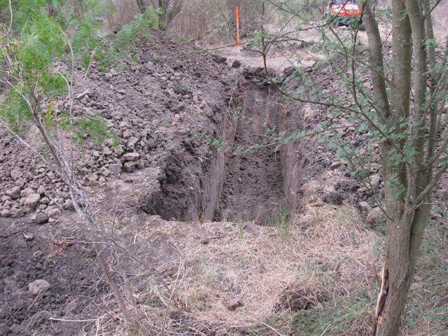
8 METHODS This project was performed in order to identify any cultural resources that might be present within the route of the proposed pipelines at the point where they cross the Nueces River and Olds Slough. Prior to entering the field, the site records at TARL and the Texas Archeological Sites Atlas were checked for the presence of previously recorded archaeological sites in the project area and vicinity as well as previous projects performed by professional archaeologists. The focus of this project was the two stream crossings (Nueces River and Olds Slough). The pipeline crosses other streams, but they were evaluated in the field and determined to be ephemeral and not likely to contain significant sites. Since the only areas to be disturbed at the surface are the entry and exit points for the horizontal directional boring, these are the areas that were investigated. In order to examine the subsurface to a sufficient depth, a backhoe was used and one trench was excavated at each entry and exit point. The fieldwork was documented by a sketch map at each area investigated, notes, profiles of the backhoe trenches, log of photographs taken, and digital photographs. At each backhoe trench selected samples of dirt were screened using quarter-inch hardware cloth, and the profiles of were scraped with a trowel and examined for cultural materials and features. The project involved 120 hours including pre-field tasks, the archaeological survey, and report preparation. The following discussion presents specific methods used and dimensions for each area. Figure 3 depicts the crossings at the river and Olds slough where the investigation took place. The Nueces River crossing was designated in the field as Area 1, and Olds Slough is Area 2. Olds Slough Crossing Backhoe Trench 1 was dug in thick brush at the entry point on the north bank of the slough and oriented north south (Figure 4). It was located 250 feet from the water and 50 feet from the dirt road that parallels the proposed pipeline. The trench was dug through clay to a depth of 178 centimeters below the existing ground surface. Its dimensions are 5 meters long and 85 centimeters wide. The east profile of the trench is depicted in Appendix I (Backhoe Trench Profiles), and a photograph of the trench during excavation is depicted in Appendix II entitled Backhoe Trench Photographs. Backhoe Trench 2 was dug in thick brush at the exit point on the south bank of the slough and oriented north south (Figure 4). It was located 92 feet from the water and 50 feet from the dirt road that parallels the proposed pipeline. The trench was dug through clay to a depth of 182 centimeters below the existing ground surface. Its dimensions are 5 meters long and 85 centimeters wide. The east profile of the trench is depicted in Appendix I (Backhoe Trench Profiles), and a photograph of the trench during excavation is depicted in Appendix II entitled Backhoe Trench Photographs. 4

9 Figure 3. Areas 1 and 2 5
10 Figure 4. Backhoe Trenches 1 and 2 6
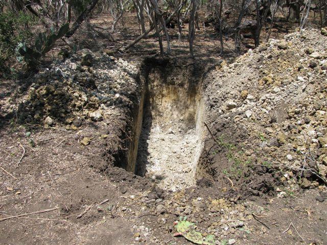
11 Nueces River Crossing Backhoe Trench 3 was dug in thick brush at the entry point on the north bank of the river in thick brush and oriented north south (Figure 5). It was located 1125 feet from the river and 50 feet from the dirt road that parallels the proposed pipeline. The trench was dug through clay to a depth of 170 centimeters below the existing ground surface. Its dimensions are 5 meters long and 85 centimeters wide. The north profile of the trench is depicted in Appendix I entitled Backhoe Trench Profiles, and a photograph of the trench during excavation is depicted in Appendix II entitled Backhoe Trench Photographs. Backhoe Trench 4 was dug in thick brush at the exit point on the south bank of the river in thick brush and oriented north south (Figure 5). It was located 565 feet from the river and 50 feet from the dirt road that parallels the proposed pipeline. The trench was dug to a depth of 160 centimeters below the existing ground surface. Its dimensions are 5 meters long and 85 centimeters wide. The soil at this location is clay over caliche with two narrow lenses of calcium carbonate at 65 centimeters and 110 centimeters below the surface. When the caliche was encountered, the excavation was terminated since this soil type pre-dates human occupation. The east profile of the trench is depicted in Appendix I entitled Backhoe Trench Profiles, and a photograph of the trench during the field excavation is depicted in Appendix II entitled Backhoe Trench Photographs. 7
12 Figure 5. Backhoe Trenches 3 and 4 8
13 RESULTS AND CONCLUSIONS Examination of the files at TARL in Austin, Texas and the Atlas revealed no sites have been recorded within any portion of the APE, and no previous archaeological projects or surveys had been conducted within the area. A search for known sites within one mile of the project area identified nine sites that varied in distance from 440 meters (41LK307) to 1380 meters (41LK223). Six of the sites are prehistoric, two are historic, and there is no information for 41LK228. All of the prehistoric sites were found in localities with soils described as sandy or loamy except for two lithic procurement sites where the soils contained large amounts of gravels. Although six sites is a small sample upon which to arrive at a meaningful interpretation regarding high probability areas for prehistoric sites, it does suggest that prehistoric sites in the area are not likely to be found in areas where clay is at or near the surface as is the case in the current project area. A visual inspection of the minor streams and tributaries revealed the presence of clay at the surface, and there were no deposits of gravels that would have been suitable for making stone tools. Therefore, these areas were not considered worthy of a formal subsurface investigation. All four backhoe trenches were excavated in areas of thick brush. Figure 6 illustrates the typical vegetation encountered. Professional studies have been conducted in Live Oak County with the most notable being along the Frio River at Choke Canyon by archaeologists from The University of Texas at San Antonio (Center for Archaeological Research). Numerous significant sites were recorded and excavated, but they were located in a more favorable setting than the area investigated for this project. 9

14 Figure 6. Thick Brush at Backhoe Trench 2 10
15 RECOMMENDATIONS No evidence of a prehistoric or historic site was found as a result of this survey. It is recommended that the client be allowed to proceed with construction as planned. Should evidence of an archaeological site be encountered during the proposed construction, all work must stop until the regulatory agencies are notified and the situation evaluated. If the route of the pipelines is moved to another area, the regulatory agencies must be informed, as additional survey may be required. This survey was conducted in accordance with the Minimum Survey Standards as outlined by the THC. 11
16 APPENDIX I BACKHOE TRENCH PROFILES
17
18
19 APPENDIX II PHOTOGRAPHS OF BACKHOE TRENCHES

20 Backhoe Trench 1 Backhoe Trench 2

21 Backhoe Trench 3 Backhoe Trench 4
AN ARCHAEOLOGICAL SURVEY FOR THE EASTHAM STATE PRISON FARM UNIT PROJECT IN HOUSTON COUNTY TEXAS
 AN ARCHAEOLOGICAL SURVEY FOR THE EASTHAM STATE PRISON FARM UNIT PROJECT IN HOUSTON COUNTY TEXAS Antiquities Permit 5693 By William E. Moore and Edward P. Baxter Brazos Valley Research Associates Contract
AN ARCHAEOLOGICAL SURVEY OF THE PROPOSED VETERANS RETIREMENT HOME PROJECT IN CENTRAL SOMERVELL COUNTY, TEXAS. Texas Antiquities Permit Number 2950
 AN ARCHAEOLOGICAL SURVEY OF THE PROPOSED VETERANS RETIREMENT HOME PROJECT IN CENTRAL SOMERVELL COUNTY, TEXAS Texas Antiquities Permit Number 2950 by William E. Moore Brazos Valley Research Associates Contract
A CULTURAL RESOURCES SURVEY FOR CITY OF NATALIA WASTEWATER IMPROVEMENT PROJECT IN MEDINA COUNTY, TEXAS
 A CULTURAL RESOURCES SURVEY FOR CITY OF NATALIA WASTEWATER IMPROVEMENT PROJECT IN MEDINA COUNTY, TEXAS Antiquities Permit 7473 By William E. Moore (Principal Investigator) Brazos Valley Research Associates
AN ARCHAEOLOGICAL SURVEY FOR THE COLEMAN COUNTY SPECIAL UTILITY DISTRICT PHASE 7 WATER LINE PROJECT IN COLEMAN COUNTY TEXAS
 AN ARCHAEOLOGICAL SURVEY FOR THE COLEMAN COUNTY SPECIAL UTILITY DISTRICT PHASE 7 WATER LINE PROJECT IN COLEMAN COUNTY TEXAS Antiquities Permit 5057 By William E. Moore Brazos Valley Research Associates
SAN FRANCISCO DISTRICT INFORMATION REQUESTED FOR VERIFICATION OF CORPS JURISDICTION
 DEPARTMENT OF THE ARMY SAN FRANCISCO DISTRICT, U.S. ARMY CORPS OF ENGINEERS 1455 MARKET STREET SAN FRANCISCO, CALIFORNIA 94103-1398 SAN FRANCISCO DISTRICT INFORMATION REQUESTED FOR VERIFICATION OF CORPS
AN ARCHAEOLOGICAL SURVEY FOR THE FORT GRIFFIN SPECIAL UTILITY DISTRICT WATER IMPROVEMENT PROJECT IN CALLAHAN AND EASTLAND COUNTIES, TEXAS
 AN ARCHAEOLOGICAL SURVEY FOR THE FORT GRIFFIN SPECIAL UTILITY DISTRICT WATER IMPROVEMENT PROJECT IN CALLAHAN AND EASTLAND COUNTIES, TEXAS Antiquities Permit 6236 By William E. Moore Brazos Valley Research
4.3 CULTURAL RESOURCES
 4.3 CULTURAL RESOURCES This section of the EIR analyzes the proposed project s potential impacts on archaeological and paleontological resources. This analysis summarizes the findings of the Archaeological
David Moore, PacifiCorp Cultural Resources Coordinator Denise DeJoseph, Project Archaeologist
 References DeJoseph, Denise 2011 Lewis River HPMP: Swift Camp FSC Survey Negative Results. Memo report submitted by Historical Research Associates to PacifiCorp, Portland, Oregon. Copies available at PacifiCorp,
Appendix I-1: Archaeological Records Search
 Appendix I-1: Archaeological Records Search South Central Coastal Information Center California State University, Fullerton Department of Anthropology MH-426 800 North State College Boulevard Fullerton,
Archaeological Survey and Evaluation at 8954 El Dorado Parkway, El Cajon, San Diego County, California
 April 16, 2013 Ms. Andrea Bitterling Helix Environmental Planning, Inc. 7578 El Cajon Blvd., Suite 200 El Cajon, California 91942 Re: Archaeological Survey and Evaluation at 8954 El Dorado Parkway, El
December 13, Kirk Shields Green Mountain Power 163 Acorn Lane Colchester, VT 05446
 December 13, 2017 Kirk Shields Green Mountain Power 163 Acorn Lane Colchester, VT 05446 RE: End of Field Letter for Archaeological Phase II Site Evaluation at Site VT-CH-1218 within the Proposed Milton
Sacred Lands File & Native American Contacts List Request
 Sacred Lands File & Native American Contacts List Request NATIVE AMERICAN HERITAGE COMMISSION 915 Capitol Mall, RM 364 Sacramento, CA 95814 (916) 653-4082 (916) 657-5390 Fax nahc@pacbell.net Information
NORTHWEST MENARD COUNTY, TEXAS Prepared for the City of Menard
 ... NATU AAtGAS PIPELINE SURVEY NORTHWEST MENARD COUNTY, TEXAS Prepared for the City of Menard Thomas C. Kelly and Fred Valdez, Jr. Center for Archaeological Research The University of Texas at San Antonio
Additional Testing for Padre Dam Eastern Service Area Secondary Connection- Alternative Site Location, San Diego County, California
 Mark Niemiec Padre Dam Municipal Water District P.O. Box 719003 9300 Fanita Parkway Santee, California 92072 Re: Additional Testing for Padre Dam Eastern Service Area Secondary Connection- Alternative
8 th 12 th Designing a Monitoring Plan Mapping & Analysis (Activities 1 2)
") 8 th 12 th Designing a Monitoring Plan Mapping & Analysis (Activities 1 2) Objectives for All Activities - To be able to define and describe the purpose and uses of topographic maps. - To define rules
8 th 12 th Designing a Monitoring Plan Mapping & Analysis (Activities 1 2) Objectives for All Activities - To be able to define and describe the purpose and uses of topographic maps. - To define rules
4.11 CULTURAL RESOURCES
 4.11 CULTURAL RESOURCES 4.11 CULTURAL RESOURCES This section summarizes the cultural resources of. Information reviewed for the summary includes the General Plan, published reports on archaeological research
PW Parkway ES Prince William County, Virginia WSSI #
 PW Parkway ES Prince William County, Virginia WSSI #15.3 Cultural Resources Site Assessment November 15 Prepared for: Prince William County Public Schools P.O. Box 39 Manassas, Virginia 1 Prepared by:
Archaeological Monitoring of Construction of a Six-Inch Force Main Sewer over Lookout Creek, Chattanooga, Hamilton County, Tennessee
 A Report Prepared for Hamilton County Engineering Department 300 Newell Tower 117 East Seventh Street Chattanooga, Tennessee 37402 Archaeological Monitoring of Construction of a Six-Inch Force Main Sewer
AN ARCHAEOLOGICAL SURVEY FOR CGG VERITAS MIDDLETON RANCH 3-D SEISMIC SURVEY IN CHAMBERS COUNTY, TEXAS. BVRA Project Number 10-21
 AN ARCHAEOLOGICAL SURVEY FOR CGG VERITAS MIDDLETON RANCH 3-D SEISMIC SURVEY IN CHAMBERS COUNTY, TEXAS BVRA Project Number 10-21 Principal Investigator William E. Moore Prepared for CGG Veritas 10300 Town
THE TWO MOST SIGNIFICANT ARCHEOLOGICAL SITES IN KERR COUNTY, TEXAS ARE THE GATLIN SITE AND THE BEARING SINK HOLE SITE.
 WHAT ARE THE MOST IMPORTANT ARCHEOLOGY SITES IN KERR COUNTY? By Steve Stoutamire THE TWO MOST SIGNIFICANT ARCHEOLOGICAL SITES IN KERR COUNTY, TEXAS ARE THE GATLIN SITE AND THE BEARING SINK HOLE SITE. Map
404 Nationwide Permit: File No. SPL PKK FWS-LA-14B F0556 Streambed Alteration Agreement Notification No.
 HELIX Environmental Planning, Inc. 7578 El Cajon Boulevard La Mesa, CA 91942 619.462.1515 tel 619.462.0552 fax www.helixepi.com July 17, 2017 Ms. Colleen Draguesku Carlsbad Fish and Wildlife Office 2177
Sacramento River Bank Protection Project
 2005 - FIELD RECONNAISSANCE REPORT OF BANK EROSION SITES - SACRAMENTO RIVER FLOOD CONTROL LEVEES AND TRIBUTARIES Sacramento River Bank Protection Project Project No. 32-0530.10, Task 3 Prepared for: U.S.
New Mexico Register / Volume XVI, Number 15 / August 15, 2005
 TITLE 4 CHAPTER 10 PART 17 CULTURAL RESOURCES CULTURAL PROPERTIES AND HISTORIC PRESERVATION STANDARDS FOR MONITORING 4.10.17.1 ISSUING AGENCY: Cultural Properties Review Committee. Contact State Historic
Starting at Rock Bottom: A Peculiar Central Texas PreClovis Culture
 Starting at Rock Bottom: A Peculiar Central Texas PreClovis Culture Background Brushy Creek grades, overall, west-northwest (WNW) to east-southeast (ESE) through the easternmost portions of the central
AN ARCHAEOLOGICAL SURVEY FOR THE EASTHAM STATE PRISON FARM A-1 and 7-1 WELL LOCATIONS IN HOUSTON COUNTY TEXAS
 AN ARCHAEOLOGICAL SURVEY FOR THE EASTHAM STATE PRISON FARM A-1 and 7-1 WELL LOCATIONS IN HOUSTON COUNTY TEXAS Antiquities Permit 4813 By William E. Moore Brazos Valley Research Associates Contract Report
Monitoring Report No. 022 GREENCASTLE BURIALS GREEN CASTLE COUNTY DOWN LICENCE NO. N/A PHILIP MACDONALD
 Monitoring Report No. 022 GREENCASTLE BURIALS GREEN CASTLE COUNTY DOWN LICENCE NO. N/A PHILIP MACDONALD Monitoring Report No. 022 Greencastle Burials (SMR No. Down 057:017) Greencastle Co. Down Philip
NEWS RELEASE UNDER SECTION 404 OF THE CLEAN WATER ACT (33 USC 1344) ACTION NUMBER SPA ABQ
 ACTION NUMBER SPA ABQ") PUBLIC NOTICE Public Notice Issue Date: //6/07 Albuquerque District Comments due: /6/08 NEWS RELEASE UNDER SECTION 0 OF THE CLEAN WATER ACT ( USC ) ACTION NUMBER SPA-06-00-ABQ BANK STABILIZATION ALONG
PUBLIC NOTICE Public Notice Issue Date: //6/07 Albuquerque District Comments due: /6/08 NEWS RELEASE UNDER SECTION 0 OF THE CLEAN WATER ACT ( USC ) ACTION NUMBER SPA-06-00-ABQ BANK STABILIZATION ALONG
IN THE UNITED STATES DISTRICT COURT FOR THE DISTRICT OF COLUMBIA DECLARATION OF TIM MENTZ, SR. IN SUPPORT OF MOTION FOR TEMPORARY RESTRAINING ORDER
 IN THE UNITED STATES DISTRICT COURT FOR THE DISTRICT OF COLUMBIA STANDING ROCK SIOUX TRIBE, Plaintiff, Case No. 1:16-cv-1534-JEB v. U.S. ARMY CORPS OF ENGINEERS, Defendant. DECLARATION OF TIM MENTZ, SR.
ENGINEER S CERTIFICATION OF FAULT AREA DEMONSTRATION (40 CFR )
") PLATTE RIVER POWER AUTHORITY RAWHIDE ENERGY STATION BOTTOM ASH TRANSFER (BAT) IMPOUNDMENTS LARIMER COUNTY, CO ENGINEER S CERTIFICATION OF FAULT AREA DEMONSTRATION (40 CFR 257.62) FOR COAL COMBUSTION RESIDUALS
PLATTE RIVER POWER AUTHORITY RAWHIDE ENERGY STATION BOTTOM ASH TRANSFER (BAT) IMPOUNDMENTS LARIMER COUNTY, CO ENGINEER S CERTIFICATION OF FAULT AREA DEMONSTRATION (40 CFR 257.62) FOR COAL COMBUSTION RESIDUALS
An Introduction to Field Explorations for Foundations
 An Introduction to Field Explorations for Foundations J. Paul Guyer, P.E., R.A. Paul Guyer is a registered mechanical engineer, civil engineer, fire protection engineer and architect with over 35 years
MINNESOTA DEEP TEST PROTOCOL PROJECT
 MINNESOTA DEEP TEST PROTOCOL PROJECT Mn/DOT Agreement No. 85878 OSA License No. 04-030 Authorized and Sponsored by: MINNESOTA DEPARTMENT OF TRANSPORTATION FEDERAL HIGHWAY ADMINISTRATION Prepared by COMMONWEALTH
Illinois State Water Survey Division
 Illinois State Water Survey Division SURFACE WATER SECTION SWS Contract Report 413 AT THE UNIVERSITY OF ILLINOIS SEDIMENTATION SURVEY OF DAWSON LAKE, MORAINE VIEW STATE PARK, MC LEAN COUNTY, ILLINOIS by
ACTON COMMUNITY WIDE ARCHAEOLOGICAL RECONNAISSANCE SURVEY. Town of Acton and PAL, Inc.
 ACTON COMMUNITY WIDE ARCHAEOLOGICAL RECONNAISSANCE SURVEY Town of Acton and PAL, Inc. Objectives and Scope of Work Four phase study; (1. research, 2. draft report outline, resource protection bylaw, 3.
MAPS AND THEIR CLASSIFICATION
 MAPPING MAPS AND THEIR CLASSIFICATION WHAT IS A MAP? A map is representation of the Earth's surface, showing how things are related to each other by distance, direction, and size. Maps are a way of showing
This report was prepared by Klohn Crippen Consultants Ltd. for Alberta Transportation Central Region under Contract No. CE053/2000.
 Alberta Transportation Central Region #401, 4902 51 Street Red Deer, Alberta T4N 6K8 June 7, 2002 Mr. Melvin Mayfield, P.Eng. Project Engineer Dear Mr. Mayfield: Central Region Landslide Assessment Site
Advanced Geologic Exploration, Inc.
 Advanced Geologic Exploration, Inc. Scientists of the Earth PO Box 1956, Chester, CA 96020 Voice: (530) 258-4228 Fax (530) 258-4339 www.advancedgeologic.com January 23, 2009 Job No. G-081201 Terri Barber,
Waterbury Dam Disturbance Mike Fitzgerald Devin Rowland
 Waterbury Dam Disturbance Mike Fitzgerald Devin Rowland Abstract The Waterbury Dam was completed in October 1938 as a method of flood control in the Winooski Valley. The construction began in April1935
ADDITIONAL PHASE IA ARCHAEOLOGICAL SURVEY FOR THE UMORE PARK SAND AND GRAVEL MINING ENVIRONMENTAL REVIEW SERVICES, DAKOTA COUNTY, MINNESOTA
 ADDITIONAL PHASE IA ARCHAEOLOGICAL SURVEY FOR THE UMORE PARK SAND AND GRAVEL MINING ENVIRONMENTAL REVIEW SERVICES, DAKOTA COUNTY, MINNESOTA ADDENDUM I Submitted to: Short Elliot Hendrickson, Inc. Submitted
Converse Consultants Geotechnical Engineering, Environmental & Groundwater Science, Inspection & Testing Services
 Converse Consultants Geotechnical Engineering, Environmental & Groundwater Science, Inspection & Testing Services Ms. Rebecca Mitchell Mt. San Antonio College Facilities Planning & Management 1100 North
UPPER COSUMNES RIVER FLOOD MAPPING
 UPPER COSUMNES RIVER FLOOD MAPPING DRAFT BASIC DATA NARRATIVE FLOOD INSURANCE STUDY SACRAMENTO COUTY, CALIFORNIA Community No. 060262 November 2008 Prepared By: CIVIL ENGINEERING SOLUTIONS, INC. 1325 Howe
PENNSYLVANIA DEPARTMENT OF TRANSPORTATION ENGINEERING DISTRICT 3-0
 PENNSYLVANIA DEPARTMENT OF TRANSPORTATION ENGINEERING DISTRICT 3-0 LYCOMING COUNTY S.R.15, SECTION C41 FINAL HYDROLOGIC AND HYDRAULIC REPORT STEAM VALLEY RUN STREAM RELOCATION DATE: June, 2006 REVISED:
Materials. Use materials meeting the following.
 208.01 Section 208. SOIL EROSION AND SEDIMENTATION CONTROL 208.01 Description. Install and maintain erosion and sedimentation controls to minimize soil erosion and to control sedimentation from affecting
Lecture 9: Reference Maps & Aerial Photography
 Lecture 9: Reference Maps & Aerial Photography I. Overview of Reference and Topographic Maps There are two basic types of maps? Reference Maps - General purpose maps & Thematic Maps - maps made for a specific
AN HISTORICAL AND ARCHAEOLOGICAL ASSESSMENT OF THE PROPOSED SAN ANTONIO BOTANICAL CENTER. Stephen L. Black
 AN HISTORICAL AND ARCHAEOLOGICAL ASSESSMENT OF THE PROPOSED SAN ANTONIO BOTANICAL CENTER Stephen L. Black Center for Archaeological Research The University of Texas at San Antonio Archaeological Survey
Cultural Resources Data
 MENIFEE VALLEY CAMPUS MASTER PLAN DRAFT EIR MT. SAN JACINTO COMMUNITY COLLEGE DISTRICT Appendices Appendix E Cultural Resources Data February 2017 MENIFEE VALLEY CAMPUS MASTER PLAN DRAFT EIR MT. SAN JACINTO
AN ARCHAEOLOGICAL SURVEY OF SUEMAUR EXPLORATION & PRODUCTION LLC s PRIDE PROSPECT IN GALVESTON COUNY TEXAS
 AN ARCHAEOLOGICAL SURVEY OF SUEMAUR EXPLORATION & PRODUCTION LLC s PRIDE PROSPECT IN GALVESTON COUNY TEXAS By William E. Moore Brazos Valley Research Associates Contract Report Number 195 2008 AN ARCHAEOLOGICAL
CHAPTER 4. Blue Heron Site (47Je1001) 2003 Investigations. By Chrisie L. Hunter
 2003 Investigations. By Chrisie L. Hunter") CHAPTER 4 Blue Heron Site (47Je1001) 2003 Investigations By Chrisie L. Hunter Introduction The Blue Heron site (47Je1001) is on the property of the Crescent Bay Hunt Club, which is located in the NE 1/4
CHAPTER 4 Blue Heron Site (47Je1001) 2003 Investigations By Chrisie L. Hunter Introduction The Blue Heron site (47Je1001) is on the property of the Crescent Bay Hunt Club, which is located in the NE 1/4
AN ARCHAEOLOGICAL SURVEY FOR THE GREENHOUSE ROAD PROJECT IN WESTERN HARRIS COUNTY, TEXAS. Brazos Valley Research Associates. Project Number 07-16
 AN ARCHAEOLOGICAL SURVEY FOR THE GREENHOUSE ROAD PROJECT IN WESTERN HARRIS COUNTY, TEXAS Brazos Valley Research Associates Project Number 07-16 Principal Investigator: William E. Moore Prepared for Bureau
Chapter 5 LiDAR Survey and Analysis in
 Chapter 5 LiDAR Survey and Analysis in 2010-2011 Christopher Fennell A surveyor s plat and town plan filed in 1836 set out an intended grid of blocks, lots, alleys, and streets for New Philadelphia. Geophysical,
Geomorphology and Archaeology: Case Studies from Western New York
 Geomorphology and Archaeology: Case Studies from Western New York New York Archaeological Council Fall Meeting Saturday October 1, 2011 Douglas J. Perrelli Geomorphology and Archaeology: Case Studies from
Archaeological Survey and Assessment of Four Wastewater Interceptor Routes in Garner, Wake Co., N.C. (EPA C )
") Archaeological Survey and Assessment of Four Wastewater Interceptor Routes in Garner, Wake Co., N.C. (EPA C370623-02) By H. Trawick \vard R. P. Stephen Davis Prepared by the Research Laboratories of Anthropology
Archaeological Survey and Assessment of Four Wastewater Interceptor Routes in Garner, Wake Co., N.C. (EPA C370623-02) By H. Trawick \vard R. P. Stephen Davis Prepared by the Research Laboratories of Anthropology
10 May Rod Walls - Director Facilities New Construction, Sustainability Hays CISD IH 35 Kyle, Texas 78640
 10 May 2017 Rod Walls - Director Facilities New Construction, Sustainability Hays CISD 21003 IH 35 Kyle, Texas 78640 Re: Hays CISD Proposed ES15 Site, Buda Phase II Soil Sampling Dear Rod: Concern has
City of Lockport Historic Resources Survey - Section METHODOLOGY
 2.0 METHODOLOGY Clinton Brown Company PN 07-008 2-1 April 2011 2.0 METHODOLOGY This methodology statement is prepared as part of the project tasks. It outlines the research sources identified, field strategies,
Geophysical Investigation of a 19th Century Archeological Site, Boston College K. Corcoran, J. Hager, M. Carnevale
 Geophysical Investigation of a 19th Century Archeological Site, Boston College K. Corcoran, J. Hager, M. Carnevale Hager GeoScience, Inc., Waltham, MA ------------------------------------------------------------------------
Big Rivers Electric Corporation Disposal of Coal Combustion Residuals (CCR) from Electric Utilities Final Rule CCR Impoundment Liner Assessment Report
 from Electric Utilities Final Rule CCR Impoundment Liner Assessment Report") Big Rivers Electric Corporation Disposal of Coal Combustion Residuals (CCR) from Electric Utilities Final Rule CCR Impoundment Liner Assessment Report CCR Surface Impoundment Information Name: Operator:
Big Rivers Electric Corporation Disposal of Coal Combustion Residuals (CCR) from Electric Utilities Final Rule CCR Impoundment Liner Assessment Report CCR Surface Impoundment Information Name: Operator:
CHAPTER 7 GEOLOGY AND SOILS
 CHAPTER 7 GEOLOGY AND SOILS 7.1 General Geology of the Area Based on the Geological map compiled by Cornec (2002) the area consists of Miocene/Pleistocene deposits as seen in figure 7.1. These are geologically
The details represented in the map depends mostly on the scale at which the map is designed.
 Measurement IN GIS A map is a visual representation of an area a symbolic depiction highlighting relationships between elements of that space such as objects, region, themes. The details represented in
patersongroup Consulting Engineers April 20, 2010 File: PG1887-LET.01R Novatech Engineering Consultants Suite 200, 240 Michael Cowpland Drive
 patersongroup April 20, 2010 File: PG1887-LET.01R Novatech Engineering Consultants Suite 200, 240 Michael Cowpland Drive Ottawa, Ontario K2M 1P6 Attention: Mr. Adam Thompson Consulting Engineers 28 Concourse
Project Background. March 9, Commissioners of Public Works 103 Saint Phillip Street Charleston, South Carolina 29203
 March 9, 2016 Commissioners of Public Works 103 Saint Phillip Street Charleston, South Carolina 29203 Attention: Reference: Mr. Frank Crawford Historic and Archaeological Properties Survey Dear Mr. Crawford:
NEEDLES S STREET LEVEE SYSTEM SAN BERNARDINO COUNTY, CALIFORNIA NLD SYSTEM ID #
 SAN BERNARDINO COUNTY, CALIFORNIA NLD SYSTEM ID # 3805030008 PERIODIC INSPECTION REPORT NO. 1 GENERALIZED EXECUTIVE SUMMARY FINAL SYSTEM RATING: MINIMALLY ACCEPTABLE FINAL RATING DATE: AUGUST 2014 PERIODIC
APPENDIX K NATIONAL HISTORIC PRESERVATION ACT COORDINATION BRAZOS ISLAND HARBOR CHANNEL IMPROVEMENT PROJECT CAMERON COUNTY, TEXAS
 APPENDIX K NATIONAL HISTORIC PRESERVATION ACT COORDINATION BRAZOS ISLAND HARBOR CHANNEL IMPROVEMENT PROJECT CAMERON COUNTY, TEXAS U.S. Army Corps of Engineers, Galveston District 2000 Fort Point Road Galveston,
SCI appreciates being of service to you on this project. Please contact me if you have any questions or comments regarding this report.
 November 7, 2013 Mr. George Ghareeb Terra Engineering, Ltd. 401 N. Main Street, Suite 1130 Peoria, Illinois 61602 RE: Phase One Cultural Resource Survey Port of East St. Louis - City of East St. Louis
STRUCTURAL STABILITY ASSESSMENT
 STRUCTURAL STABILITY ASSESSMENT CFR 257.73(d) Bottom Ash Pond Complex Cardinal Plant Brilliant, Ohio October, 2016 Prepared for: Cardinal Operating Company Cardinal Plant Brilliant, Ohio Prepared by: Geotechnical
Evaluation/Monitoring Report No. 259
 SITE 100M EAST OF 16 LEARMORE ROAD CASTLEGORE CASTLEDERG COUNTY TYRONE LICENCE NO.: AE/13/36E NAOMI CARVER 1 Site Specific Information Site Name: 100m east of 16 Learmore Road, Castlederg, Co. Tyrone Townland:
Laboratory Exercise #3 The Hydrologic Cycle and Running Water Processes
 Laboratory Exercise #3 The Hydrologic Cycle and Running Water Processes page - 1 Section A - The Hydrologic Cycle Figure 1 illustrates the hydrologic cycle which quantifies how water is cycled throughout
Saganashkee Slough - McMahon Woods Section 506 Great Lakes Fishery & Ecosystem Restoration Study
 2015 Saganashkee Slough - McMahon Woods Section 506 Great Lakes Fishery & Ecosystem Restoration Study Appendix B Civil Design USACE Chicago District August 2015 TABLE OF CONTENTS INTRODUCTION... 3 General...
Part 1: Buildings to be Demolished. Submitted to
 Stage 1 & 2 Archaeological Assessment London Psychiatric Hospital 850 Highbury Avenue North City of London (Former London Township) Middlesex County, Ontario Part 1: Buildings to be Demolished Submitted
3.12 Geology and Topography Affected Environment
 3 Affected Environment and Environmental Consequences 3.12 Geology and Topography 3.12.1 Affected Environment 3.12.1.1 Earthquakes Sterling Highway MP 45 60 Project Draft SEIS The Kenai Peninsula is predisposed
ARCHAEOLOGICAL SURVEY OF BANDERA CITY PARK, BANDERA COUNTY, TEXAS
 ARCHAEOLOGICAL SURVEY OF BANDERA CITY PARK, BANDERA COUNTY, TEXAS Ronald W. Burkett I / Center for Archaeological Research The University of Texas at San Antonio Archaeological Survey Report, No. 183 1989
RE: End of Field Letter for the Proposed Milton Mears Farm Road Solar Project, Milton, Chittenden County, Vermont
 October 10, 2017 Kirk Shields Green Mountain Power 163 Acorn Lane Colchester, VT 05446 RE: End of Field Letter for the Proposed Milton Mears Farm Road Solar Project, Milton, Chittenden County, Vermont
THE BERRYESSA CREEK SITE CA-SCL-593. Robert Cartier Richard San Filippo Archeological Resource Management 496 North Fifth Street San Jose, CA 95112
 THE BERRYESSA CREEK SITE CA-SCL-593 Robert Cartier Richard San Filippo Archeological Resource Management 496 North Fifth Street San Jose, CA 95112 ABSTRACT This presentation discusses the nature and chronology
COLORADO CULTURAL RESOURCE SURVEY Management Data Form Rev. 11/10
 COLORADO CULTURAL RESOURCE SURVEY OAHP1400 Rev. 11/10 A should be completed for each cultural resource recorded during an archaeological survey. Isolated finds and revisits are the exception and they do
PHASE 1 STUDIES UPDATE EROSION WORKING GROUP
 PHASE 1 STUDIES UPDATE EROSION WORKING GROUP Presented By MICHAEL WOLFF, PG Erosion Study Area Manager West Valley Demonstration Project Quarterly Public Meeting February 24, 2016 OUTLINE Study 1 Terrain
1.1 What is Site Fingerprinting?
 Site Fingerprinting Utilizing GIS/GPS Technology 1.1 What is Site Fingerprinting? Site fingerprinting is a planning tool used to design communities where protection of natural resources is the primary
Bramley Grange, Horsham Road, Bramley, Surrey
 Bramley Grange, Horsham Road, Bramley, Surrey An Archaeological Evaluation for English Villages Housing Association by Stephen Hammond Thames Valley Archaeological Services Ltd Site Code BGB 03/95 October
ACQUISITION, PROCESSING AND INTERPRETATION TECHNIQUES FOR GROUND-PENETRATING RADAR MAPPING OF BURIED PIT-STRUCTURES IN THE AMERICAN SOUTHWEST
 ACQUISITION, PROCESSING AND INTERPRETATION TECHNIQUES FOR GROUND-PENETRATING RADAR MAPPING OF BURIED PIT-STRUCTURES IN THE AMERICAN SOUTHWEST Lawrence B. Conyers Deparunent of Anthropology, University
The Rising Sun, Guildford Road, Fetcham, Surrey
 The Rising Sun, Guildford Road, Fetcham, Surrey An Archaeological Evaluation for Bovis Homes Limited by Steve Ford Thames Valley Archaeological Services Ltd Site Code RGF04/80 March 2005 Summary Site name:
AN ARCHAEOLOGICAL SURVEY FOR THE POYNER WATER SUPPLY CORPORATION WATER SYSTEM IMPROVEMENTS PROJECT IN ANDERSON COUNTY, TEXAS. BVRA Project 05-11
 AN ARCHAEOLOGICAL SURVEY FOR THE POYNER WATER SUPPLY CORPORATION WATER SYSTEM IMPROVEMENTS PROJECT IN ANDERSON COUNTY, TEXAS BVRA Project 05-11 Principal Investigator William E. Moore, RPA Prepared for
Hydrogeological Assessment for Part of Lots 2 and 3, Concession 5, Township of Thurlow, County of Hastings 1.0 INTRODUCTION. 1.
 February 10,2017 25506400 Ontario Ltd. Foxboro, ON Attention: Brad Newbatt Re: Hydrogeological Assessment for Part of Lots 2 and 3, Concession 5, Township of Thurlow, County of Hastings 1.0 INTRODUCTION
Soil Sampling Results Former Truck Maintenance Garage
 Soil Sampling Results Former Truck Maintenance Garage Maine Yankee Decommissioning Project Corrective Measures Study May 2004 Prepared for: Maine Yankee 321 Old Ferry Road, Bailey Point Wiscasset, ME 04578
Preliminary Geotechnical Evaluation Gooseberry Point Pedestrian Improvements Whatcom County, Washington SITE AND PROJECT DESCRIPTION
 File No. 12-100 Geotechnical & Earthquake Engineering Consultants Mr. Kevin Brown, P.E. Gray & Osborne, Inc. 3710 168 th Street NE, Suite B210 Arlington, Washington 98223 Subject: Draft Report Preliminary
LOMR SUBMITTAL LOWER NEHALEM RIVER TILLAMOOK COUNTY, OREGON
 LOMR SUBMITTAL LOWER NEHALEM RIVER TILLAMOOK COUNTY, OREGON Prepared for: TILLAMOOK COUNTY DEPARTMENT OF COMMUNITY DEVELOPMENT 1510-B THIRD STREET TILLAMOOK, OR 97141 Prepared by: 10300 SW GREENBURG ROAD,
Information for File # MMJ; Trunk Highway (TH) 7 / Louisiana Ave. Interchange Project
 7 / Louisiana Ave. Interchange Project") Information for File # 2013-00531-MMJ; Trunk Highway (TH) 7 / Louisiana Ave. Interchange Project Applicant: City of St. Louis Park Corps Contact: Melissa Jenny Address: U.S. Army Corps of Engineers Attn:
Information for File # 2013-00531-MMJ; Trunk Highway (TH) 7 / Louisiana Ave. Interchange Project Applicant: City of St. Louis Park Corps Contact: Melissa Jenny Address: U.S. Army Corps of Engineers Attn:
DRAFT
 A84536-22, A81184-3 Discovery of Human Remains On Site Lead Licensing and Environmental Assessment Archaeologist Manitoba Historic Resources Branch (HRB) RCMP STOP activities at location Step 6
MEMORANDUM FOR SWG
 MEMORANDUM FOR SWG-2007-1623 Subject: Jurisdictional Determination (JD) for SWG-2007-1623 on Interdunal Wetlands Adjacent to Traditional Navigable Waters (TNWs) Summary The U.S. Environmental Protection
Topographic Map Series:
 DEFINITION OF A MAP A MAP IS A GEOGRAPHIC PREPRESENTATION OF A PORTION OF THE EARTH S SURFACE DRAWN TO SCALE, AS SEEN FROM ABOVE. IT S USES COLORS, SYMBOLS AND LABELS TO REPRESENT FEATURES FOUND ON THE
A GPR ASSESSMENT OF THE NAPLES CANAL 8CR59: PHASE II NAPLES, FLORIDA ARCHAEOLOGICAL AND HISTORICAL CONSERVANCY, INC.
 A GPR ASSESSMENT OF THE NAPLES CANAL 8CR59: PHASE II NAPLES, FLORIDA ARCHAEOLOGICAL AND HISTORICAL CONSERVANCY, INC. AHC TECNICAL REPORT NO. 1023 JUNE 2014 A GPR ASSESSMENT OF THE NAPLES CANAL 8CR59: PHASE
GEOLOGY Warren Mining District Idaho County, Idaho March SlI4HARY
 r?..:. F-_.,'.': t.,.. I ~ j. ii lucky BEN motp GEOLOGY Warren Mining District Idaho County, Idaho March 1984 SlI4HARY.., The Lucky Ben Croup of claims cover a gold prospect located in the Wdrren Mining
TRAFFIC ALERT FOR WEEK OF February 4 8, 2008
 TRAFFIC ALERT FOR WEEK OF February 4 8, 2008 Highway work zones in the Staunton District The following is a list of highway work that might affect traffic in the Staunton transportation district during
EROSIONAL FEATURES. reflect
 reflect Have you ever looked at the land around you and wondered what processes shaped what you see? Perhaps you see mountains, valleys, rivers, or canyons. Do you know how long these geologic features
Author(s): Charles K. Cover, P.E. Federal Energy Regulatory Commission
: Charles K. Cover, P.E. Federal Energy Regulatory Commission") Using GIS to Help Manage a National Energy Program Author(s): Charles K. Cover, P.E. Federal Energy Regulatory Commission The Federal Energy Regulatory Commission (FERC) has statutory oversight on key
Using GIS to Help Manage a National Energy Program Author(s): Charles K. Cover, P.E. Federal Energy Regulatory Commission The Federal Energy Regulatory Commission (FERC) has statutory oversight on key
APPENDIX 3B OCCURRENCE OF SIGNIFICANT RIVER ALLUVIUM AQUIFERS IN THE PLATEAU REGION
 Plateau Region Water Plan January 2011 APPENDIX 3B OCCURRENCE OF SIGNIFICANT RIVER ALLUVIUM AQUIFERS IN THE PLATEAU REGION Occurrence of Significant River Alluvium Aquifers in the Plateau Region Prepared
August 14, James Bolton 312 Perry Lane Lovingston, VA
 August 14, 2017 James Bolton 312 Perry Lane Lovingston, VA 22949 jrbolton035@gmail.com Department of Environmental Quality Office of Wetlands & Stream Protection P.O. Box 1105 Richmond, VA 23218 comment-acp@deq.virginia.gov
Internship Report Nate Stanley Center for Archaeological Studies
 Internship Report Nate Stanley Center for Archaeological Studies Introduction: Beginning in May of 2010, the center of Archaeological Studies (CAS) at Texas State University San Marcos conducted a cultural
Slope Stability Evaluation Ground Anchor Construction Area White Point Landslide San Pedro District Los Angeles, California.
 Slope Stability Evaluation Ground Anchor Construction Area White Point Landslide San Pedro District Los Angeles, California Submitted To: Mr. Gene Edwards City of Los Angeles Department of Public Works
Erosional Features. What processes shaped this landscape?
 Have you ever looked at the land around you and wondered what processes shaped what you see? Perhaps you see mountains, valleys, rivers, or canyons. Do you know how long these geologic features have been
A. My name is Watsun Randolph and my business address is 45 Horner Street Warrenton
 DIRECT TESTIMONY OF WATSUN RANDOLPH ON BEHALF OF PIEDMONT ENVIRONMENTAL COUNCIL BEFORE THE STATE CORPORATION COMMISSION OF VIRGINIA CASE NOS. PUE-00-000 AND PUE-00-000 0 Q. PLEASE STATE YOUR NAME AND BUSINESS
DATA REPORT GEOTECHNICAL INVESTIGATION GALVESTON CRUISE TERMINAL 2 GALVESTON, TEXAS
 DATA REPORT GEOTECHNICAL INVESTIGATION GALVESTON CRUISE TERMINAL 2 GALVESTON, TEXAS SUBMITTED TO PORT OF GALVESTON 123 ROSENBERG AVENUE, 8TH FLOOR GALVESTON, TEXAS 77553 BY HVJ ASSOCIATES, INC. HOUSTON,
Stratigraphy Layers of Time in the Earth by Carol Schlenk
 Subject: Science, Social Studies Grade level: 11-12 Stratigraphy Layers of Time in the Earth by Carol Schlenk Rationale: This lesson introduces students to the concept of stratification as a historical
Archaeological Report Guidelines
 Archaeological Report Guidelines Archaeological reports for different stages of project development should adequately reflect the level of investigation completed. The following format outline is intended