DRAFT
|
|
|
- Valentine Simmons
- 5 years ago
- Views:
Transcription


1
2
3
4
5
6
7
8
9
10
11
12 A ,
13
14
15
16
17 A
18
19
20
21 Discovery of Human Remains On Site Lead Licensing and Environmental Assessment Archaeologist Manitoba Historic Resources Branch (HRB) RCMP STOP activities at location Step 6 Step 5 Step 4 Step 3 Step 2 Step 1 Immediately mark discovery location with flagging tape and cordon off with temporary fencing (minimum buffer distance 35 m radius from centre of discovery) Contact Licensing and Environmental Assessment Contact archaeologist and communities/ organizations with protocols Contact HRB Leave remains in place. Size of buffer may be adjusted once archaeologist, in consultation with HRB, examine site [i.e., on a case-by-case basis]. Determine whether human remains are present If remains human, contact RCMP For human remains, if not already known, confirm whether RCMP and/or the Chief Medical Examiner have an ongoing interest in remains under The Fatalities Inquiries Act. If remains are nonforensic and their removal is required to protect remains, lead exhumation of human remains. If remains are forensic in nature or cannot be immediately determined whether remains are forensic, RCMP and Chief Medical Examiner have jurisdiction over area of find and human remains
22 Discovery of Human Remains On Site Lead Licensing and Environmental Assessment Archaeologist Manitoba Historic Resources Branch (HRB) RCMP Community Representative(s) may arrange for and facilitate an appropriate ceremony HRB and/or archaeologist directs cautious investigation of surrounding surface prior to exhumation of remains to determine if other human remains or artifacts are in area Step 9 Step 8 Step 7 Construction activities in vicinity of site that will not impact artifacts or related archeological activities may proceed LEA would work with communities to decide whether and what type of analysis would be done on remains. Locate and document human remains with GPS, record relevant data and submit with reports to HRB, construction supervisor and Community Representative(s) No construction activities within buffer until archaeologist has completed archaeological investigation Oversee basic noninvasive physical anthropological techniques, including drawings, sketches and initial measurements to assist in determining basic information about individual
23 Discovery of Cultural and Heritage Resources On Site Lead Licensing and Environmental Assessment Archaeologist Manitoba Historic Resources Branch (HRB) Step 7 Step 6 Step 5 Step 4 Step 3 Step 2 Step 1 STOP activities at location Contact Licensing and Environmental Assessment Establish buffer around find (minimum 35 m radius from centre of discovery) Talk to archaeologist and immediately them photos of find Contact archaeologist and communities/ organizations with protocols If discovery includes sacred or ceremonial objects, Community Representative(s) may arrange and facilitate appropriate ceremony Contact HRB Talk to On Site Lead, review photos and determine significance of find Obtain Heritage Permit from HRB Direct cautious exploratory investigation to determine if other artifacts in area
24 Discovery of Heritage Resources On Site Lead Licensing and Environmental Assessment Archaeologist Manitoba Historic Resources Branch (HRB) Step 12 Step 11 Step 10 Step 9 Step 8 Step 7 Construction activities in vicinity of site that will not impact artifacts or related archeological activities may proceed Undertake: extended surface reconnaissance; - shovel tests at regular intervals perpendicular and parallel to artifact deposit; - controlled collection of data about artifacts, including mapping using global positioning system or chain and compass; and - test excavations, if necessary Locate and document finds Locate with GPS, and record document relevant the finds with data GPS, record relevant data Collect and place artifacts in protective container include date, project, contents, coordinates and other information, including site classification If MH cannot avoid site based on progress of construction, direct site s removal by standard and most appropriate excavation methods. Submit copies of technical data and reports to HRB and MH Evaluate heritage resource site and findings presented by archaeologist to determine if further mitigative action is necessary before construction in site vicinity may continue No construction activities will take place at site until HRB is satisfied that site removal is complete and meets provincial standards
25
26
27
28
29
30
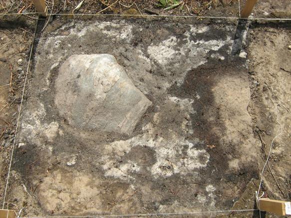
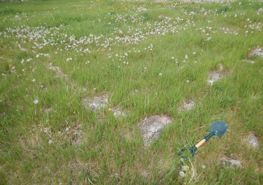
31
32
33
34


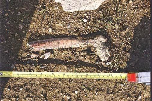
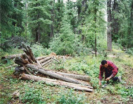
35 Often metal objects are found abandoned along old portage routes, former trails and at longforgotten cabin sites. This old, blue enameled kettle was found in the hollow of a tree with tin cups nestled inside. The way that metal tins were constructed can be dated. Glass fragments can also be identified as belonging to a certain time period. The morphology and markings on bottles help archaeologists to date sites.


36


37


38 There are many different kinds of stone alignments that have been constructed by humans: Way-markers, caches, ceremonial sites, building foundations, tepee rings and burials are the major rock features that are found during archaeological investigations. These can be on or above the ground surface or buried features.


39
40
41
42
43
Tłı chǫ All-season Road Archaeological Site Chance Find Protocol
 Tłı chǫ All-season Road Archaeological Site Chance Find Protocol Insert applicable LWB project numbers Version 1 Revision History REVISION HISTORY Version Date Notes/Revisions 1 Original version of plan
Chance Find Management Procedures for the Village of Queen Charlotte
 Chance Find Management Procedures for the Village of Queen Charlotte Prepared for: The Village of Queen Charlotte P.O. Box 580 903 A Oceanview Drive Queen Charlotte, BC V0T 1S0 By: Kleanza Consulting Ltd.
New Mexico Register / Volume XVI, Number 15 / August 15, 2005
 TITLE 4 CHAPTER 10 PART 17 CULTURAL RESOURCES CULTURAL PROPERTIES AND HISTORIC PRESERVATION STANDARDS FOR MONITORING 4.10.17.1 ISSUING AGENCY: Cultural Properties Review Committee. Contact State Historic
11 PALAEONTOLOGY, ARCHAEOLOGY AND CULTURAL HERITAGE IMPACTS
 11 PALAEONTOLOGY, ARCHAEOLOGY AND CULTURAL HERITAGE IMPACTS This chapter discusses the potential impacts on palaeontology, archaeology and cultural heritage resources resulting from the establishment of
Yukon Mineral Exploration Best Management Practices for Heritage Resources April 2010 Edition 1
 Tourism & Culture Heritage Resources Tourism & Culture Heritage Resources Yukon Mineral Exploration Best Management Practices for Heritage Resources April 2010 Edition 1 DISCLAIMER Nothing in the Yukon
Environmental Scoping Report for the proposed establishment of a New Coal-Fired Power Station in the Lephalale Area, Limpopo Province
 12. ARCHAEOLOGICAL AND HERITAGE RESOURCES The National Cultural History Museum was contracted by Bohlweki Environmental to survey an area in which it is proposed to re-align an existing road and construct
4.3 CULTURAL RESOURCES
 4.3 CULTURAL RESOURCES This section of the EIR analyzes the proposed project s potential impacts on archaeological and paleontological resources. This analysis summarizes the findings of the Archaeological
Bipole III Transmission Project Construction Environmental Protection Plan Construction Section N2 Environmentally Sensitive Site Locations Map 81
 ± DOCUMENT PATH: G :\_GIS_PROJECT_FOLDER\00_HYDRO\111440054_BPIII_EPP\ARCMAP\ESS_N2\BPIII_CENVPP_N1N2N3N4C1SECTIONBASEMAP_MAPBOOK_BTB_STANTEC_20131201.MXD 196 Coordinate System: UTM Zone NAD83 Data Source:
Appendix I-1: Archaeological Records Search
 Appendix I-1: Archaeological Records Search South Central Coastal Information Center California State University, Fullerton Department of Anthropology MH-426 800 North State College Boulevard Fullerton,
Monitoring Program Terms of Reference HERITAGE AND CULTURE INFORMATION PLAN
 Monitoring Program Terms of Reference HERITAGE AND CULTURE INFORMATION PLAN GMSMON-21a Peace - Archaeological Overview Assessment May 2, 2008 1.0 OVERVIEW HERITAGE AND CULTURE INFORMATION PLAN TERMS OF
AN ARCHAEOLOGICAL SURVEY FOR THE DCP MIDSTREAM THREE RIVERS PLANT TO CGP 51 PROJECT IN LIVE OAK COUNTY, TEXAS
 AN ARCHAEOLOGICAL SURVEY FOR THE DCP MIDSTREAM THREE RIVERS PLANT TO CGP 51 PROJECT IN LIVE OAK COUNTY, TEXAS By William E. Moore Brazos Valley Research Associates Contract Report Number 251 2011 AN ARCHAEOLOGICAL
Yukon Wilderness Tourism Best Management Practices for Heritage Resources February 2009 Edition 1
 Tourism & Culture Heritage Resources Tourism & Culture Heritage Resources Yukon Wilderness Tourism Best Management Practices for Heritage Resources February 2009 Edition 1 DISCLAIMER Nothing in the Yukon
Monitoring Program Terms of Reference HERITAGE AND CULTURE INFORMATION PLAN
 Monitoring Program Terms of Reference HERITAGE AND CULTURE INFORMATION PLAN GMSMON-21b Peace Erosion Monitoring of Archaeological Resources May 2, 2008 1.0 OVERVIEW HERITAGE AND CULTURE INFORMATION PLAN
Appendix D: Chance Find Procedures
 Heritage Statement for a Proposed Acetylene Gas Production Facility, located near Witkopdorp, Daleside, south of Johannesburg ERM2556 Appendix D: Chance Find Procedures CHANCE FIND PROCEDURES (CFPS) FOR
Bipole III Transmission Project Construction Environmental Protection Plan Construction Section N1 Environmentally Sensitive Site Locations Map 25
 ± DOCUMENT PATH: G :\_GIS_PROJECT_FOLDER\00_HYDRO\111440054_BPIII_EPP\ARCMAP\ESS_N1\BPIII_CENVPP_N1N2N3N4C1SECTIONBASEMAP_MAPBOOK_BTB_STANTEC_20131207.MXD N1-S11 Tower 10 E-723206, N-6272609 N1-Soils-154
4.11 CULTURAL RESOURCES
 4.11 CULTURAL RESOURCES 4.11 CULTURAL RESOURCES This section summarizes the cultural resources of. Information reviewed for the summary includes the General Plan, published reports on archaeological research
Archaeological Survey and Evaluation at 8954 El Dorado Parkway, El Cajon, San Diego County, California
 April 16, 2013 Ms. Andrea Bitterling Helix Environmental Planning, Inc. 7578 El Cajon Blvd., Suite 200 El Cajon, California 91942 Re: Archaeological Survey and Evaluation at 8954 El Dorado Parkway, El
Update on Archaeological Resources Assessment for Phase 1 Dredge Areas
 Update on Archaeological Resources Assessment for Phase 1 Dredge Areas Prepared by URS Corp for General Electric Presented by John Vetter, USEPA CAG Meeting December 8, 2005 1 Presentation Outline Overview
SOLUT TO AUGUST 25 T SPREAD 7 AUGUST 20 TH
 MANITOBA METIS FEDER ATION MATRIX SOLUT IONS INC. PARTNERSHIP INDIGENOUS CONSTRUCTION MONITORING WEEKLY REPORT SPREAD 7 AUGUST 20 TH TO AUGUST 25 T T H 1 1. PURPOSE OF THIS REPORT The report is a weekly
Report on Geophysical Survey Na Vrsku, Sahy, Slovakia Coordinates: 48⁰,4,45 N 18⁰,56,23 E. April 2018
 Report on Geophysical Survey Na Vrsku, Sahy, Slovakia Coordinates: 48⁰,4,45 N 18⁰,56,23 E April 2018 Mark Graham BA(Hons), BSc, MA Grampus Heritage and Training Ltd, Ashgill, Threapland, Wigton, Cumbria,
AN ARCHAEOLOGICAL SURVEY FOR THE EASTHAM STATE PRISON FARM UNIT PROJECT IN HOUSTON COUNTY TEXAS
 AN ARCHAEOLOGICAL SURVEY FOR THE EASTHAM STATE PRISON FARM UNIT PROJECT IN HOUSTON COUNTY TEXAS Antiquities Permit 5693 By William E. Moore and Edward P. Baxter Brazos Valley Research Associates Contract
2017/03/31. Figure 9. British military graveyard at Fort Cox. Figure 10. Memorial stone. HIA: Fort Cox College Water and Sanitation Services
 2017/03/31 Figure 9. British military graveyard at Fort Cox Figure 10. Memorial stone 22 2017/03/31 Figure 11. Memorial stone Previous Studies An extensive research into the SAHRIS database resulted in
Archaeological Glossary
 Archaeological Glossary analysis: the stage of archaeological research that involves the description and classification of archaeological data. anthropology: the study of humans, including the variety
Kansas Archaeology Month
 Activities for Discovering Prehistoric Trails TIME: 45 min. Kansas Archaeology Month Discovering Prehistoric Trails This lesson is divided into four sections: instructional goals, advanced preparation,
¾À 280. ESS Features Heritage. Points of Access* !( Proposed Access Point. !( Archaeological Water. Major Stream Crossing Abandoned Rail Crossing # #
 ± DOCUMENT PATH: G :\_GIS_PROJECT_FOLDER\00_HYDRO\111440054_BPIII_EPP\ARCMAP\ESS_N1\BPIII_CENVPP_N1N2N3N4C1SECTIONBASEMAP_MAPBOOK_BTB_STANTEC_20131207.MXD 386 N1-S30 385 BURNTWOOD RIVER Coordinate System:
Sacred Lands File & Native American Contacts List Request
 Sacred Lands File & Native American Contacts List Request NATIVE AMERICAN HERITAGE COMMISSION 915 Capitol Mall, RM 364 Sacramento, CA 95814 (916) 653-4082 (916) 657-5390 Fax nahc@pacbell.net Information
Name. Designed and Produced for the Orleans County Historical Society by Andrew R. Beaupré, RPA
 Name Archaeology! Archeology! What is Archaeology? Archaeology is the scientific study of people of the past by studying the places people lived, the objects they used, and traces in the soil left by human
IV. Excavation and Analysis of Human Remains
 IV. Excavation and Analysis of Human Remains Excavation and Analysis of Human Remains Introduction...80 Burial Site Identification...80 Cataloging Burial Sites...82 Excavation of Human Remains...84 Documentation
SCHEDULE C: STANDARDS FOR ARCHAEOLOGICAL IMPACT ASSESSMENT
 SCHEDULE C: STANDARDS FOR ARCHAEOLOGICAL IMPACT ASSESSMENT AND REPORTING IN DEBERT AND BELMONT, NOVA SCOTIA MAY 2014 INTRODUCTION In March 2008, regulations to the Special Places Protection Act were adopted
Section 4.5 Cultural Resources Introduction
 4.5 invisible_toc_marker County of Kern Section 4.5 Cultural Resources 4.5.1 Introduction As described in Chapter 2 of this Supplemental EIR (SEIR), an EIR was previously certified for the Alta Oak Creek
Chapter 9. Archaeology Resources. Accessing Resources. Chapter 9: Archaeology Resources
 139 Chapter 9 Archaeology Resources Archaeology is the study of human cultures through the physical remains. Archaeology is a field within anthropology. Archaeological materials are physical evidence of
DATING HOW OLD IS THIS THING?
 DATING HOW OLD IS THIS THING? WHY? u CROSS-CULTURAL COMPARISON v UNDERSTANDING DEVELOPMENT AND CHANGE OF A PARTICULAR GROUP OR CULTURE w UNDERSTANDING SITE FORMATION PROCESSES x UNDERSTANDING REGIONAL
Humber River Watershed Scenario Modelling and Analysis Report. Section 4.6 Cultural Heritage
 Humber River Watershed Scenario Modelling and Analysis Report Section 4.6 Cultural Heritage TABLE OF CONTENTS 4.3 CULTURAL HERITAGE... 4.6-1 4.6.1 Key Indicators... 4.6-1 4.6.2 Cultural Heritage Analysis
Columbia River Project Water Use Plan. Monitoring Program Terms of Reference HERITAGE MANAGEMENT PLAN
 HERITAGE MANAGEMENT PLAN CLBMON-50 Arrow Lakes Reservoir Heritage Monitoring Wind and Wave Erosion 23 October 2007 1.0 OVERVIEW HERITAGE MANAGEMENT PLAN TERMS OF REFERENCE This document presents Terms
Mapping historic sites in rural Manitoba: development, themes, and applications. Gordon Goldsborough Manitoba Historical Society
 Mapping historic sites in rural Manitoba: development, themes, and applications Gordon Goldsborough Manitoba Historical Society 2016 Presentation outline What is the MHS Historic Sites of Manitoba project?
Phase II: Evaluation According to National Register Criteria
 Phase II: Evaluation According to National Register Criteria Introduction... 39 Determinations of Eligibility under Section 106... 40 Evaluation under State Historic Preservation Legislation... 41 Nominating
Selected Archeological Terms
 Page 1 of 6 Selected Archeological Terms Links General Reference Bibliographies Glossaries Terms A b C D E F G H i j k l M N O P q R S T U V w x y z ADAPTATION: The process of change to better conform
P60 High Resolution Geophysics Inside Machado de Castro Museum - Coimbra, Centre Portugal
 P60 High Resolution Geophysics Inside Machado de Castro Museum - Coimbra, Centre Portugal C. Grangeia (University of Aveiro), M.J. Senos Matias* (University of Aveiro), F. Figueiredo (University of Coimbra),
Early Exploration Permit Activity Information
 Early Exploration Permit Activity Information Activities That Require an Early Exploration Permit: Line cutting that is a width greater than 1.5 metres Mechanized stripping of a total surface area of greater
Swaledale and Arkengarthdale Archaeology Group
 Swaledale and Arkengarthdale Archaeology Group Bellerby Moor GPS Earthwork Survey Report prepared by: Tim Laurie and Stephen Eastmead. Swaledale and Arkengarthdale Archaeology Group. January 27/01/2012.
HERITAGE ASSESSMENT REPORT ZEUS SUBSTATION EXPANSION, VLAKFONTEIN 328, GERT SIBANDE (DC 30) DISTRICT, MPUMALANGA, SOUTH AFRICA
 DISTRICT, MPUMALANGA, SOUTH AFRICA") HERITAGE ASSESSMENT REPORT ZEUS SUBSTATION EXPANSION, VLAKFONTEIN 328, GERT SIBANDE (DC 30) DISTRICT, MPUMALANGA, SOUTH AFRICA REPORT FOR PBA INTERNATIONAL Zoë Henderson & Chriselle Koortzen 19 June 2007
HERITAGE ASSESSMENT REPORT ZEUS SUBSTATION EXPANSION, VLAKFONTEIN 328, GERT SIBANDE (DC 30) DISTRICT, MPUMALANGA, SOUTH AFRICA REPORT FOR PBA INTERNATIONAL Zoë Henderson & Chriselle Koortzen 19 June 2007
RE: End of Field Letter for the Proposed Milton Mears Farm Road Solar Project, Milton, Chittenden County, Vermont
 October 10, 2017 Kirk Shields Green Mountain Power 163 Acorn Lane Colchester, VT 05446 RE: End of Field Letter for the Proposed Milton Mears Farm Road Solar Project, Milton, Chittenden County, Vermont
NEWS RELEASE UNDER SECTION 404 OF THE CLEAN WATER ACT (33 USC 1344) ACTION NUMBER SPA ABQ
 ACTION NUMBER SPA ABQ") PUBLIC NOTICE Public Notice Issue Date: //6/07 Albuquerque District Comments due: /6/08 NEWS RELEASE UNDER SECTION 0 OF THE CLEAN WATER ACT ( USC ) ACTION NUMBER SPA-06-00-ABQ BANK STABILIZATION ALONG
PUBLIC NOTICE Public Notice Issue Date: //6/07 Albuquerque District Comments due: /6/08 NEWS RELEASE UNDER SECTION 0 OF THE CLEAN WATER ACT ( USC ) ACTION NUMBER SPA-06-00-ABQ BANK STABILIZATION ALONG
THE USE OF GEOMATICS IN CULTURAL HERITAGE AND ARCHAEOLOGY FOR VARIOUS PURPOSES
 THE USE OF GEOMATICS IN CULTURAL HERITAGE AND ARCHAEOLOGY FOR VARIOUS PURPOSES FEBRUARY 2013 AL BEIDA GEOPLAN CONTENT Company Profile Concept Objectives and Strategies Data Production Methods Data Samples
Mapping the Dead. By: Sharon Mollick, GISP Assistant Planner Cumberland County Department of Planning & Development Bridgeton, New Jersey USA
 Mapping the Dead By: Sharon Mollick, GISP Assistant Planner Cumberland County Department of Planning & Development Bridgeton, New Jersey 08302 USA Abstract The Old Cohansey Baptist Cemetery, located in
PW Parkway ES Prince William County, Virginia WSSI #
 PW Parkway ES Prince William County, Virginia WSSI #15.3 Cultural Resources Site Assessment November 15 Prepared for: Prince William County Public Schools P.O. Box 39 Manassas, Virginia 1 Prepared by:
Monitoring Report No. 022 GREENCASTLE BURIALS GREEN CASTLE COUNTY DOWN LICENCE NO. N/A PHILIP MACDONALD
 Monitoring Report No. 022 GREENCASTLE BURIALS GREEN CASTLE COUNTY DOWN LICENCE NO. N/A PHILIP MACDONALD Monitoring Report No. 022 Greencastle Burials (SMR No. Down 057:017) Greencastle Co. Down Philip
IV. Environmental Impact Analysis D.2 Cultural Resources Archaeological and Paleontological Resources
 IV. Environmental Impact Analysis D.2 Cultural Resources Archaeological and Paleontological Resources 1. Introduction The following section of the Draft EIR evaluates potential impacts related to archaeological
Relative Dating Introduction: Types of Relative Dating:
 Relative Dating Introduction: In the early stage of prehistoric studies, dating of any event or site was obtained tentatively. A particular event or specimen is dated in relation to other event or some
Geophysical Survey of Wisconsin Burial Site BRO-0033 Wixom Cemetery, Rock County, Wisconsin
 Lawrence University Lux Archaeological Reports Anthropology Department 6-2015 Geophysical Survey of Wisconsin Burial Site BRO-0033 Wixom Cemetery, Rock County, Wisconsin Peter N. Peregrine Lawrence University
Glossary of Common Terms. Guide 2. BAJR Practical Guide Series held by authors
 Glossary of Common Terms Guide 2 BAJR Practical Guide Series 2008 held by authors Glossary of common archaeological terms : compiled 28/04/2004 absolute dating: Absolute dating is based upon a specific
Archaeological Assessment of Scroggs Hill Forest
 Archaeological Assessment of Scroggs Hill Forest Prepared for Fulton Hogan Limited by Chris Jacomb and Emma Brooks Southern Pacific Archaeological Research August 2009 CONTENTS Introduction and Background...
THE TWO MOST SIGNIFICANT ARCHEOLOGICAL SITES IN KERR COUNTY, TEXAS ARE THE GATLIN SITE AND THE BEARING SINK HOLE SITE.
 WHAT ARE THE MOST IMPORTANT ARCHEOLOGY SITES IN KERR COUNTY? By Steve Stoutamire THE TWO MOST SIGNIFICANT ARCHEOLOGICAL SITES IN KERR COUNTY, TEXAS ARE THE GATLIN SITE AND THE BEARING SINK HOLE SITE. Map
Initial Borehole Drilling and Testing in or Near Ignace
 JUNE 2016 PRELIMINARY ASSESSMENT OF POTENTIAL SUITABILITY Initial Borehole Drilling and Testing in or Near Ignace DRAFT FOR DISCUSSION WITH COMMUNITIES In 2010, the Nuclear Waste Management Organization
NOSE HILL PARK LINEAR BIRD TRANSECTS 2006
 NOSE HILL PARK LINEAR BIRD TRANSECTS 2006 Prepared by: Sweetgrass Consultants Ltd. Calgary, AB For: CITY OF CALGARY PARKS January 2007 Sweetgrass Consultants Ltd. 15112 Deer Run Dr. S.E. Calgary, AB T2J
New Mexico Register / Volume XVI, Number 15 / August 15, 2005
 TITLE 4 CHAPTER 10 PART 15 CULTURAL RESOURCES CULTURAL PROPERTIES AND HISTORIC PRESERVATION STANDARDS FOR SURVEY AND INVENTORY 4.10.15.1 ISSUING AGENCY: Cultural Properties Review Committee. Contact State
Magnets and Compasses
 Magnets and Compasses Adapted from education.com How Does a Compass Work? You are lost in the wilderness. You know there is a highway several miles north of you, but you don t know which direction north
RAILWAYS AND FISH: HOW TO PROTECT AND ENHANCE FISH HABITAT VALUES AT STREAM CROSSINGS THROUGH PROJECT DESIGN AND CONSTRUCTION
 RAILWAYS AND FISH: HOW TO PROTECT AND ENHANCE FISH HABITAT VALUES AT STREAM CROSSINGS THROUGH PROJECT DESIGN AND CONSTRUCTION Rail Environment Conference November 2016 AGENDA Objective Background Benefits
Development of the Portal of Cultural Heritage Objects the Kingdom of Poland
 Evgeny KOVALEV, Natalia KOVALEVA Sholokhov Moscow State University for the Humanities, Russia Hadi SALEH Vladimir State University Named After Alexander and Nikolay Stoletovs, Russia Development of the
ADDITIONAL PALEO-INDIAN BIFACE VARIABILITY IN NORTHWESTERN ONTARIO. William A. Ross ABSTRACT INTRODUCTION
 ROSS: NORTHWESTERN PALEO-INDIAN BIFACES 21 ADDITIONAL PALEO-INDIAN BIFACE VARIABILITY IN NORTHWESTERN ONTARIO William A. Ross ABSTRACT Two recently recovered bifaces, which can be assigned to the Paleo-Indian
Required Documents. Title: Number: AEP Administration 2017 No. 1. Provincial Wetlands and Water Boundaries Section. Effective Date: September 1, 2017
 Title: Number: Program Name: Provincial Wetlands and Water Boundaries Section Effective Date: September 1, 2017 This document was updated on: August 25, 2017 The Provincial Wetlands and Water Boundaries
CLT/HER/CHP/OG 1- page 29
 CLT/HER/CHP/OG 1- page 29 MODEL INVENTORY SHEET FOR UNDERWATER CULTURAL HERITAGE COUNTRY REGION, PROVINCE COMPETENT AUTHORITY REGISTERED BY (name, position) Date Email / Tel nº SITE NAME (provide also
MOOI-MGENI TRANSFER SCHEME, PHASE 2, KWA-ZULU NATAL HERITAGE IMPACT ASSESSMENT
 MOOI-MGENI TRANSFER SCHEME, PHASE 2, KWA-ZULU NATAL HERITAGE IMPACT ASSESSMENT Gavin Anderson Umlando: Archaeological Tourism and Resource Management PO Box 102532, Meerensee, 3901 Phone/fax: 035-7531785
AFRICAN HERITAGE CONSULTANTS CC 2001/077745/23
 AFRICAN HERITAGE CONSULTANTS CC 2001/077745/23 DR. UDO S KÜSEL Tel: (012) 567 5046 Fax: 086 594 9721 Cell: 082 498 0673 E-mail: udo@nconnect.co.za Website: www.africanheritage.co.za P.O. Box 652 Magalieskruin
Parowan Gap Nature s Perfect Observatory by V.Garth Norman
 Parowan Gap Nature s Perfect Observatory by V.Garth Norman CFI, Inc. Publication Available @ www.amazon.com Archaeological Research Consultants ARCON Inc. 2006 No part of this presentation may be reproduced
Salvaging the ties in Albion. Here behind the former M&StL depot in Albion, the ties are salvaged. This view is to the south.
 Salvaging the ties in Albion. Here behind the former M&StL depot in Albion, the ties are salvaged. This view is to the south. The ties in the foreground are loose, some ties in the background have already
interpret archaeological strata using the law of superposition; apply cross-dating to determine the age of other artifacts.
 Grade 8: Standardized Task Competency Goal 5: The learner will conduct investigations and utilize appropriate technologies and information systems to build an understanding of evidence of evolution in
COLORADO CULTURAL RESOURCE SURVEY Management Data Form Rev. 11/10
 COLORADO CULTURAL RESOURCE SURVEY OAHP1400 Rev. 11/10 A should be completed for each cultural resource recorded during an archaeological survey. Isolated finds and revisits are the exception and they do
Pickan s Dyke, Dalmellington: Archaeological Investigation
 Pickan s Dyke, Dalmellington: Archaeological Investigation Stage 2 Post-Excavation Research Design by Douglas Gordon issued 27 th September 2012 on behalf of Forestry Commission Scotland Contents Introduction...
Project 4 Wildlife Technical Report. Lake. Winnipeg. Project 4 WTR. Ecological Land Classification in the Project 4 Study Area
 Ecoregion Number and Ecodistrict Name 90, Berens River 90, Wrong Project 1: PR304 to Berens River Project 4: to Transmission Line Ecodistricts: Government of Canada, Agriculture and Agri-Food Canada, Ecological
Lesson 2 DRAWING A SIMPLE MAP WALT: Draw a simple map. Lesson 3 DRAWING A MAP TO SCALE. scale map.
 Year 3 GEOGRAPHY Mapping Lesson 1 WHAT MAPS SHOW US WALT: Describe the purpose of a map. Lesson 2 DRAWING A SIMPLE MAP WALT: Draw a simple map. Lesson 3 DRAWING A MAP TO SCALE WALT: Draw a simple scale
GEOPHYSICAL SURVEY REPORT. Timolin, County Kildare. Date: 18/01/2016. Licence: 15R0133
 GEOPHYSICAL SURVEY REPORT Date: 18/01/2016 Licence: 15R0133 J. M. Leigh Surveys 124 Oaklawn West Leixlip County Kildare www.jmlsurveys.com 01 615 4647 Consultants. J. M. Leigh Surveys 124 Oaklawn West,
Archaeological Evaluation of Land off Hubbards Lane, Boughton Monchelsea, Kent
 Archaeological Evaluation of Land off Hubbards Lane, Boughton Monchelsea, Kent NGR: 576190 151300 Site Code: HUB/EV/16 (Planning Application: 16/500014/OUT/MA) SWAT Archaeology The Office, School Farm
Introduction to Archaeology: Notes 6 Stratigraphy and site formation Copyright Bruce Owen 2009 The most basic question about an archaeological site
 Introduction to Archaeology: Notes 6 Stratigraphy and site formation Copyright Bruce Owen 2009 The most basic question about an archaeological site why is this stuff here, and arranged the way it is? why
THE STAGE 1 ARCHAEOLOGICAL ASSESSMENT OF 1 EVANS AVENUE, PART OF LOTS 2 & 3, CONCESSION 10, TOWNSHI P OF AMARANTH, DUFFERIN COUNTY
 THE STAGE 1 ARCHAEOLOGICAL ASSESSMENT OF 1 EVANS AVENUE, PART OF LOTS 2 & 3, CONCESSION 10, TOWNSHI P OF AMARANTH, DUFFERIN COUNTY THE STAGE 1 ARCHAEOLOGICAL ASSESSMENT OF 1 EVANS AVENUE, PART OF LOTS
NORTHWEST MENARD COUNTY, TEXAS Prepared for the City of Menard
 ... NATU AAtGAS PIPELINE SURVEY NORTHWEST MENARD COUNTY, TEXAS Prepared for the City of Menard Thomas C. Kelly and Fred Valdez, Jr. Center for Archaeological Research The University of Texas at San Antonio
Chapter Archaeological Dating Methods
 Chapter 3 3.1. Archaeological Dating Methods Everything which has come down to us from heathendom is wrapped in a thick fog; it belongs to a space of time we cannot measure. We know that it is older than
A303 Stonehenge Highways England Consultation the response from Honouring the Ancient Dead
 A303 Stonehenge Highways England Consultation the response from Honouring the Ancient Dead Highways England (HE) plans along the A303, A358 and A30 to create a world-class Expressway to link the south
Archaeology and Geophysics at the Chillicothe Site, Ohio, USA
 info@gemsys.on.ca Archaeology and Geophysics at the Chillicothe Site, Ohio, USA In this short paper, we summarize the recent procedings of the National Parks Service Archaeology Workshop in Chillicothe,
GEOGRAPHY. ATAR course examination, Question/Answer booklet. Time allowed for this paper Reading time before commencing work:
 ATAR course examination, 2017 Question/Answer booklet GEOGRAPHY Please place your student identification label in this box Student number: In figures In words Time allowed for this paper Reading time before
Legacy Resource Management Program Archaeological Reconnaissance Survey VOLUME I. Guide for Archaeological Resource Management
 Legacy Resource Management Program Archaeological Reconnaissance Survey VOLUME I Guide for Archaeological Resource Management United States Naval Academy, Annapolis, MD. September, 1994 Prepared by: John
GEOL151 Fall 2016: Lab for Week #9 Glacial Erosion, Sediment Transport, and Deposition in the Champlain Valley
 GEOL151 Fall 2016: Lab for Week #9 Glacial Erosion, Sediment Transport, and Deposition in the Champlain Valley Overview This week, we will delve into glacial processes and landforms. Glaciers are generally
Geospatial Data Model for Archaeology Site Data
 Authors: David T. Hansen, Barbara D. Simpson, Anastasia Leigh, Patrick Welch, and Lorri Peltz-Lewis Geospatial Data Model for Archaeology Site Data Presented by David T. Hansen and Barbara D. Simpson at
Report on the Geophysical survey undertaken at Kouphovouno between 28 th June and 2 nd July.
 Report on the Geophysical survey undertaken at Kouphovouno between 28 th June and 2 nd July. Introduction: A team comprising of two undergraduate students (Anna Moles & James Taylor) and two postgraduates
Table-Top Exercise for Emergency Preparedness Evaluation: Little Anse, Isle Madame
 Table-Top Exercise for Emergency Preparedness Evaluation: Little Anse, Isle Madame Alexander Chung, M.Sc. Candidate C-Change Student Research Associate May 2013 The Community of Little Anse Coastal community
Early Exploration Plan Activity Information
 Early Exploration Plan Activity Information Activities That Require an Early Exploration Plan: Line cutting that is a width of 1.5 metres or less; Geophysical surveys on the ground requiring the use of
5. Environmental Analysis
 5.4 Cultural resources include places, objects, and settlements that reflect group or individual religious, archaeological, architectural, or paleontological activities. Such resources provide information
HONDURAN INSTITUTE OF ANTHROPOLOGY AND HISTORY SURFACE SURVEY NUEVA ARCADIA AND LA COFRADÍA WIND PROJECT
 HONDURAN INSTITUTE OF ANTHROPOLOGY AND HISTORY SURFACE SURVEY NUEVA ARCADIA AND LA COFRADÍA WIND PROJECT PROVINCE OF FRANCISCO MORAZAN Prepared for The Sub Management of Heritage I.H.A.H. II. Researcher:
Introduction to Archaeology: Notes 9 Chronology, part 2 Copyright Bruce Owen 2009 Trapped-charge dating methods Several different kinds, one basic
 Introduction to Archaeology: Notes 9 Chronology, part 2 Copyright Bruce Owen 2009 Trapped-charge dating methods Several different kinds, one basic principle All measure the accumulated damage (displaced
Post-doc fellowships to non-eu researchers FINAL REPORT. Home Institute: Centro de Investigaciones Marinas, Universidad de La Habana, CUBA
 Recipient: Maickel Armenteros Almanza. Post-doc fellowships to non-eu researchers FINAL REPORT Home Institute: Centro de Investigaciones Marinas, Universidad de La Habana, CUBA Promoter: Prof. Dr. Wilfrida
AUTOMATIC DETECTION OF ARCHAEOLOGICAL SITES USING A HYBRID PROCESS OF REMOTE SENSING, GIS TECHNIQUES AND A SHAPE DETECTION ALGORITHM
 AUTOMATIC DETECTION OF ARCHAEOLOGICAL SITES USING A HYBRID PROCESS OF REMOTE SENSING, GIS TECHNIQUES AND A SHAPE DETECTION ALGORITHM Ian Bridgwood (1), Michael Schultz Rasmussen (2), Mikael Kamp Sørensen
Minnesota Transportation Museum
 Minnesota Transportation Museum Minnesota Social Studies s Alignment Second Grade 1 Code Benchmark 1. Citizenship and Government 1. Civic Skills. Civic Values and Principles of Democracy 4. Governmental
Feasibility Study for Potential Removal of McLane & Goldman Dams Souhegan River, Milford, NH. Public Kick-off Meeting
 Feasibility Study for Potential Removal of McLane & Goldman Dams Souhegan River, Milford, NH Public Kick-off Meeting Mark Wamser Gomez and Sullivan Engineers, P.C. 603-428-4960 Aug 16, 2010 Agenda Opening
SETTLEMENT. Student exercises. The Kuril Biocomplexity Project:
 SETTLEMENT Student exercises Table of Content Vocabulary... 67 Background Information... 69 Introduction... 7 Part 1... 71 Part 2... 8 76 Vocabulary Deposit: Sediment put down on the earth surface in the
David Moore, PacifiCorp Cultural Resources Coordinator Denise DeJoseph, Project Archaeologist
 References DeJoseph, Denise 2011 Lewis River HPMP: Swift Camp FSC Survey Negative Results. Memo report submitted by Historical Research Associates to PacifiCorp, Portland, Oregon. Copies available at PacifiCorp,
Best Practices Protocol for Methamphetamine Clandestine Labs
 Best Practices Protocol for Methamphetamine Clandestine Labs Diane Catley Forensic Science Supervisor Virginia Dept. of Forensic Science 6600 Northside High School Drive Roanoke VA 24019 540.283.5931 May,
Excavations at Clocken Syke Farm, Dairy Lane,Dacre By Nidderdale Iron-age Archaeology community group 2015 and 2016
 Excavations at Clocken Syke Farm, Dairy Lane,Dacre By Nidderdale Iron-age Archaeology community group 2015 and 2016 1 Introduction The Nidderdale Iron-Age group and its forerunners have been investigating
The last three sections of the main body of this report consist of:
 Threatened and Endangered Species Geological Hazards Floodplains Cultural Resources Hazardous Materials A Cost Analysis section that provides comparative conceptual-level costs follows the Environmental
Linear Referencing Systems (LRS) Support for Municipal Asset Management Systems
 Support for Municipal Asset Management Systems") Linear Referencing Systems (LRS) Support for Municipal Asset Management Systems Esri Canada Infrastructure Asset Management Leadership Forum November 1, 2017 Toronto, ON David Loukes, P. Eng., FEC Andy
Linear Referencing Systems (LRS) Support for Municipal Asset Management Systems Esri Canada Infrastructure Asset Management Leadership Forum November 1, 2017 Toronto, ON David Loukes, P. Eng., FEC Andy
CK107 BA in Geographical and Archaeological Sciences
 CK107 BA in Geographical and Archaeological Sciences CK107 BA in Geographical and Archaeological Science Geography and Archaeology are closely related disciplines, concerned with concepts of time and space