NOSE HILL PARK LINEAR BIRD TRANSECTS 2006
|
|
|
- Camron Dawson
- 6 years ago
- Views:
Transcription


1 NOSE HILL PARK LINEAR BIRD TRANSECTS 2006 Prepared by: Sweetgrass Consultants Ltd. Calgary, AB For: CITY OF CALGARY PARKS January 2007 Sweetgrass Consultants Ltd Deer Run Dr. S.E. Calgary, AB T2J 5M8 CANADA phone: (403)
2 TABLE OF CONTENTS EXECUTIVE SUMMARY...iii 1 INTRODUCTION OBJECTIVES WORK PLAN AND METHODS RESULTS AND ANALYSIS Overall Summary Breeding Birds in Proximity to Proposed Trail Redevelopment SUGGESTED TRAIL AND PATHWAY CONSTRUCTION MITIGATION Potential Impacts Overall Along Existing Major Routes Along Existing Minor Routes Suggested Mitigation Strategies Grassland/Shrubland Routes Many Owls Valley-Woodland Nest Searches... 5 LIST OF MAPS NOSE HILL BIRD MONITORING TRAIL TRANSECTS APPENDICES APPENDIX 1. LOCATION OF LINEAR BIRD TRANSECTS... 7 i
3 EXECUTIVE SUMMARY Sweetgrass Consultants Ltd. was contracted in 2006 to conduct linear transect surveys for birds along selected trails and pathways in Nose Hill Natural Environment Park to assist in the implementation of the Nose Hill Trail and Pathway Plan and associated trail and pathway system developments. The objectives of the study included (1) the observation and documentation of birds nesting and foraging in proximity to pathways and trails; (2) analysis of results; and (3) formulation of mitigation strategies for trail and pathway construction. A total of 13 linear transect routes in 6 areas of the Park were surveyed four times from June 25 to July 20, in conjunction with the circular bird plot surveys (see accompanying report). Singing and non-singing birds were recorded in two zones: within a band 5 meters on either side of the trail, and on 100 meters on either side of the trail. Transect routes and individual stations were mapped in ArcGIS and UTMs of individual stations were recorded. All observations were entered into a database that included information on species, location, date, time, habitat, observer, age/sex, behavior (singing, calling, flying etc.), and relevant notes. In total, 12 species of birds that nest in the Park were observed in close proximity to pathways and trails. Of these species, only three were recorded on more than four occasions, and only two of these Savannah Sparrow and Clay-colored Sparrow--were abundant. These two species are also common in the Calgary area. No rare or sensitive species were recorded along the linear transects. The areas where birds were most frequently observed in close proximity to trails included trees and shrubs (individual or patches) and trails with dense vegetation along narrow walkways. While there were numerous observations of family groups (adults and young) close to trails, it is predicted that there is only a low density of nests in these situations. Based on the experience of the researchers, there is a greater chance that nests would be located along the smaller, lowuse, more densely vegetated trails rather than along the busier, more heavily disturbed trails. Potential impacts and suggested mitigation strategies for trail and pathway construction are presented. ii
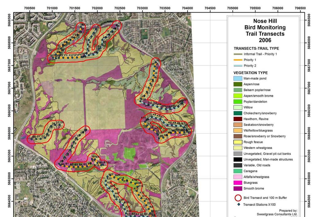
4 1. INTRODUCTION Sweetgrass Consultants Ltd. was contracted in June 2006 to conduct linear transect surveys for birds along selected trails and pathways in Nose Hill Natural Environment Park. The results of this assessment assisted in planning and mitigating some of the potential impacts associated with implementation of the Nose Hill Trail and Pathway Plan, including planned trail and pathway construction. This study was undertaken as a follow-up to the Biophysical Impact Assessment Nose Hill Park Cross-Park Pathways Routes, prepared by URSUS Ecosystems Management Ltd. in June 2006, which identified potential project impacts to breeding birds during the breeding season (May 1 to July 31). In recognition of the potential project impacts identified in the BIA, The City of Calgary Parks initiated a park-wide bird monitoring study (see accompanying report) and this linear transect study to assess current bird populations and use patterns in the park, more closely examine the potential impacts of trail and pathway construction activities, and develop mitigation strategies to reduce the potential impacts of construction activities during the breeding bird season. 2. OBJECTIVES The objectives of this study were: 1. documentation of birds nesting and foraging in proximity to pathways and trails; 2. analysis of results (with particular attention to potential effects of pathway construction on breeding birds); and 3. formulation of recommendations for mitigating trail and pathway construction activities. 3. WORK PLAN AND METHODS The study methodology included the following:. linear transect routes were selected by Parks staff and the consultant along representative and high priority pathways and trails, and, where possible, in the vicinity of circular bird plots. a total of 13 linear transect routes in 6 areas of the Park were selected. transect routes and individual stations were mapped in ArcGIS (see Nose Hill Bird Monitoring Transects Map on next page) and UTMs of individual stations were recorded (see Appendix 1). each route was walked four times, between sunrise and 10:00 a.m., on June 25 & 26, and July 5 & 20; the first three surveys were conducted at the same time as circular bird plots. all singing and non-singing birds observed were recorded in two zones: ON-LINE (within 5m on either side of the pathway or trail) and OFF-LINE (within 100 m on either side of the pathway or trail). observations were entered into a database and included information on species, location, date, time, habitat, observer, age/sex, behavior (singing, calling, flying etc.), and relevant notes. 1
5 2
6 4. RESULTS AND ANALYSIS 4.1 Overall Summary A total of 34 species of birds were observed on the linear transect surveys. Of this total, 12 were observed in close proximity to (within 5 m of) a pathway or trail, and only 3 of these species were found frequently. It was not the intent of this study to analyze habitat use for all species and habitats along the linear transects. However, the pertinent information (e.g. habitat, behavior etc.) is in the electronic database and could be analyzed if so desired. Intent of the 2006 linear bird transect data gathering was to determine what impacts, if any, that trail and pathway construction could have on nesting birds. A printout of all linear bird transect observations in the electronic database is presented as file material for this study. 4.2 Breeding Birds in Proximity to Proposed Trail Redevelopment The following species were observed in close proximity to pathways and trails--all 12 species nested in the Park in Behavior is noted for each species; family groups and singing indicate probable nesting in the general area and possibility of nesting near the trail. Flying birds (i.e., not in the habitat) were not included: Species Infrequently Occurring Along Trails American Goldfinch (including singing) Black-billed Magpie (foraging along trail edges) Brewer's Blackbird (possible nest) Cedar Waxwing (perched/feeding in shrubbery) Gray Partridge (included a family group) House Wren (singing) Le Conte's Sparrow (singing) Lincoln's Sparrow (family group and singing) Ring-necked Pheasant (flushed from trail edge) Vesper Sparrow (included singing birds and family groups) Species Frequently Occurring Along Trails American Robin (foraging) 13 records (including foraging on trails) Clay-colored Sparrow (singing birds and family groups) 61 records (included singing birds and family groups/nests) Savannah Sparrow 142 records (included singing birds and family groups/nests) Both groups of species above are widespread in Alberta and are not particularly sensitive to disturbance. The two most frequently encountered species on the linear transects, Clay-colored Sparrow and Savannah Sparrow, are the most abundant birds in the Park. Of the 12 species observed, only one, the Vesper Sparrow, is a species of concern in the Park because of declining numbers observed through circular plot surveys, from 1993 to
7 Areas where birds were most frequently observed in close proximity to trails included trees and shrubs (individual or patches) and trails with dense vegetation along narrow paths. While there were numerous observations of adults giving alarm calls near nests or young, based on the researchers' experience, nests within 5 meters of busier trails would be unlikely because of the disturbance factor or human activity. Activity in these areas appeared to be mainly family groups (adults and young) moving about after young had left the nest. 5. SUGGESTED TRAIL AND PATHWAY CONSTRUCTION MITIGATION If trail or pathway construction is undertaken during the breeding season (roughly from May 1 to August 1) without applying suggested mitigation measures there is a possibility of destroying nests or young, albeit a relatively low possibility based on recent plot and transect surveys that demonstrated overall low populations of nesting birds in Nose Hill Park. 5.1 Potential Impacts Overall Since no rare or sensitive species were observed in close proximity to trails and pathways during linear transect surveys, and only a relatively low density of nests are predicted in close proximity to trails and pathways, it is expected that the overall impact of trail and pathway construction on bird populations will be minimal Along Existing Major Routes Based on field observations, it is expected that construction activities along major Park desire lines, which include routes with minimal vegetation cover, compacted soil, and broad widths of disturbances, would have a low probability of impacting nesting species it is predicted that very few birds nest directly along these routes Along Existing Minor Routes Minor trails in the Park, with lusher vegetation, narrower width of disturbance, and less human activity, are more likely than major trails to have nesting birds in the immediate vicinity. Construction at these sites would, therefore, have a higher probability of impacting nesting species, when compared with major routes; however, the density of nesting species is still predicted to be relatively low compared with habitat at greater distance from the trails. 5.2 Suggested Mitigation Strategies Since construction of major park routes (including cross-park pathways and the upper plateau route) may require the duration of an entire construction season (May-October) to complete, and, in the case of the chip-seal treatment on the asphalt pathways, may require the majority of work to be completed prior to August 15 to meet specifications, mitigation strategies have been developed to largely reduce the direct impacts of construction on breeding birds. Mitigation strategies have been developed specifically for routes through the Park's grassland/shrubland 4
8 communities and woodland communities Grassland/Shrubland Routes If construction is to begin between May 1 and July 31: 1. Mow grass and clear/prune shrubs immediately along trail or pathway routes to eliminate available habitat for nesting birds. 2. Carry out the mowing and clearing of the route prior to the establishment of early nests (May 1). 3. The mow and clearing width should be 3 m, or the zone for construction activity (surface disturbance, machine/worker traffic area, temporary public access), whichever is greater. 4. Only above-ground clearing of shrubs is required root clearing may be undertaken during actual trail operations. 5. The zone of disturbance through large patches of native vegetation should be minimal, which will necessitate that smaller scale machinery be used, where possible Many Owls Valley Woodland If construction is to begin between May 1 and July 31: 1. Commence construction activities, including vehicle traffic, in Many Owls Valley prior to May 1 to avoid sensory disturbances to species establishing nests in the woodland. 2. If construction activities in Many Owls Valley do not commence prior to May 1, no construction activities would be permitted within a 100m radius from the aspen woodland until August 1. It should be noted that The City of Calgary Parks, Emergency Medical Services (EMS), Police and Fire vehicles make use of the Many Owls Valley access road on an intermittent and asneeded basis for year-round access into the park. The intent of this mitigation measure is not to restrict current City access practices, since it is not expected that intermittent use of the site would have the same potential impact that continuous construction traffic could have Nest Searches If the above mitigation measures for grassland/shrubland routes and the Many Owls Valley Woodland are not implemented prior to May 1, the following mitigation measures should be employed: Grassland/Shrubland: 1. Conduct nest searches immediately before mowing and clearing activities and/or the start of trail construction activities along grassland/shrubland routes after May If active nests are discovered, avoid the area until after the young have fledged. Construction should proceed as soon as possible after an area has been assessed as being free of nesting birds. 3. The following are guidelines for the timing of nesting activities for prospective nesting species that frequently occur along park trails: Clay-colored Sparrow days (incubation) days (in nest) = 20 days approx. maximum nesting period 5
9 Savannah Sparrow days (incubation) days (in nest) = 26 days approx. maximum nesting period Many Owls Valley - Woodland 1. Prior to construction in the Many Owls Valley woodland habitat, conduct searches for nests of birds of prey (species sensitive to disturbance from human activity during the nesting season) within 100 m of route. Potential nesting species include Cooper's Hawk, Sharpshinned Hawk, Merlin, Northern Harrier, Great-horned Owl, and Long-eared Owl, but other species should also be watched for. 2. While only two of these species, Cooper's Hawk and Northern Harrier, nested in the Park in 2006, the others either have been documented nesting in the past or were observed in the Park in 2006 and suitable nesting habitat exists. Based on information from 2006 bird surveys, the probability for most of these species to be nesting in the Park is relatively low; however, because bird surveys in 2006 were not initiated until early June, some earlynesting species could have been missed. 3. Searches for birds of prey would include diurnal surveys, as well as nocturnal calling surveys for owls. 4. Construction activity within 100 m of active bird of prey nests should be delayed until after the young have fledged. 5. The following are guidelines for the timing of nesting activities for prospective nesting species: 6. The following are guidelines for the timing of nesting activities for sensitive birds of prey: Cooper's Hawk 36 days (incubation) days (in nest) + 10 days (young return to nest for food) = 70 days approx. maximum nesting period Swainson's Hawk 26 days (incubation) days (in nest) = 61 days approx. maximum nesting period Northern Harrier days (incubation) + 37 days (in or near nest) = 76 days approx. maximum nesting period Merlin days (incubation) days (in nest) = 62 days approx. maximum nesting period. 6
10 APPENDIX 1. LOCATION OF LINEAR BIRD TRANSECTS UTM COORDINATES Note that an electronic waypoint file has been provided to facilitate uploading to GPS units. DATUM NAD83 GRID 11U STATION GRID EAST NORTH A0 11U A1 11U A2 11U A3 11U A4 11U A5 11U A6 11U A7 11U A8 11U A9 11U A10 11U A11 11U A12 11U A13 11U A14 11U A15 11U A16 11U A17 11U A18 11U A19 11U A20 11U A21 11U A22 11U A23 11U A24 11U A25 11U A26 11U A27 11U A28 11U A29 11U A30 11U A31 11U A32 11U B0 11U B1 11U B2 11U B3 11U B4 11U B5 11U
11 B6 11U B7 11U B8 11U B9 11U B10 11U B11 11U B12 11U C0 11U C1 11U C2 11U C3 11U C4 11U C5 11U C6 11U C7 11U C8 11U C9 11U C10 11U D0 11U D1 11U D2 11U D3 11U D4 11U D5 11U D6 11U D7 11U D8 11U E0 11U E1 11U E2 11U E3 11U E4 11U E5 11U E6 11U E7 11U E8 11U E9 11U E10 11U E11 11U F0 11U F1 11U F2 11U F3 11U F4 11U F5 11U F6 11U G0 11U G1 11U G2 11U G3 11U
12 G4 11U H0 11U H1 11U H2 11U H3 11U H4 11U H5 11U H6 11U H7 11U I0 11U I1 11U I2 11U I4 11U I5 11U I6 11U I3 11U I7 11U J0 11U J1 11U J2 11U J3 11U J4 11U J5 11U J6 11U J7 11U J8 11U J9 11U J10 11U J11 11U J12 11U J13 11U J14 11U J15 11U J16 11U J17 11U J18 11U J19 11U J20 11U J21 11U K0 11U K1 11U K2 11U K3 11U K4 11U K5 11U K6 11U K7 11U K8 11U K9 11U K10 11U
13 K11 11U L0 11U L1 11U L2 11U L3 11U L4 11U L5 11U M0 11U M1 11U M2 11U M3 11U M4 11U M5 11U M6 11U M7 11U
Bipole III Transmission Project Construction Environmental Protection Plan Construction Section N2 Environmentally Sensitive Site Locations Map 81
 ± DOCUMENT PATH: G :\_GIS_PROJECT_FOLDER\00_HYDRO\111440054_BPIII_EPP\ARCMAP\ESS_N2\BPIII_CENVPP_N1N2N3N4C1SECTIONBASEMAP_MAPBOOK_BTB_STANTEC_20131201.MXD 196 Coordinate System: UTM Zone NAD83 Data Source:
Bipole III Transmission Project Construction Environmental Protection Plan Construction Section N1 Environmentally Sensitive Site Locations Map 25
 ± DOCUMENT PATH: G :\_GIS_PROJECT_FOLDER\00_HYDRO\111440054_BPIII_EPP\ARCMAP\ESS_N1\BPIII_CENVPP_N1N2N3N4C1SECTIONBASEMAP_MAPBOOK_BTB_STANTEC_20131207.MXD N1-S11 Tower 10 E-723206, N-6272609 N1-Soils-154
Parking Regulations Dundas Street West, from Bathurst Street to Dovercourt Road
 STAFF REPORT ACTION REQUIRED Parking Regulations Dundas Street West, from Bathurst Street to Dovercourt Road Date: October 28, 2008 To: From: Toronto and East York Community Council Director, Transportation
H IGHWAY 3 WILDLIFE MORTALITY
 Miistakis Institute for the Rockies H IGHWAY 3 WILDLIFE MORTALITY CONTENTS Introduction 1 Methods 2 Data Limitations 3 Results 3 Discussion 8 Special points of interest: The analysis includes mortality
An Investigation of New Philadelphia Using Thermal Infrared Remote Sensing. (Last updated: Nov. 25, 2008)
") An Investigation of New Philadelphia Using Thermal Infrared Remote Sensing (Last updated: Nov. 25, 2008) Bryan S. Haley Center for Archaeological Research University of Mississippi Research results in
An Investigation of New Philadelphia Using Thermal Infrared Remote Sensing (Last updated: Nov. 25, 2008) Bryan S. Haley Center for Archaeological Research University of Mississippi Research results in
COUNCIL POLICY BACKGROUND
 COUNCIL POLICY Policy Title: Snow and Ice Control Policy Policy Number: TP004 Report Number: TTP2003-39, C2007-44, LPT2011-57 Approved by: City Council Effective Date: Interim policy approved 2009 December
¾À 280. ESS Features Heritage. Points of Access* !( Proposed Access Point. !( Archaeological Water. Major Stream Crossing Abandoned Rail Crossing # #
 ± DOCUMENT PATH: G :\_GIS_PROJECT_FOLDER\00_HYDRO\111440054_BPIII_EPP\ARCMAP\ESS_N1\BPIII_CENVPP_N1N2N3N4C1SECTIONBASEMAP_MAPBOOK_BTB_STANTEC_20131207.MXD 386 N1-S30 385 BURNTWOOD RIVER Coordinate System:
This report was prepared by Klohn Crippen Consultants Ltd. for Alberta Transportation Central Region under Contract No. CE053/2000.
 Alberta Transportation Central Region #401, 4902 51 Street Red Deer, Alberta T4N 6K8 June 7, 2002 Mr. Melvin Mayfield, P.Eng. Project Engineer Dear Mr. Mayfield: Central Region Landslide Assessment Site
Southwest LRT Habitat Analysis. May 2016 Southwest LRT Project Technical Report
 Southwest LRT Habitat Analysis Southwest LRT Project Technical Report This page intentionally blank. Executive Summary This technical report describes the habitat analysis that was performed to support
Geophysical Survey Summary Luas F1 Line Lucan Blackhorse, County Dublin
 Luas F1 Line, Co. Dublin Geophysical Survey Summary Luas F1 Line Lucan Blackhorse, County Dublin Introduction A geophysical survey in three pre-defined survey areas (Areas 1, 2 and 3) has been undertaken
NATHAN HALE HIGH SCHOOL PARKING AND TRAFFIC ANALYSIS. Table of Contents
 Parking and Traffic Analysis Seattle, WA Prepared for: URS Corporation 1501 4th Avenue, Suite 1400 Seattle, WA 98101-1616 Prepared by: Mirai Transportation Planning & Engineering 11410 NE 122nd Way, Suite
Third Annual Monitoring Report Tidal Wetland Restoration 159 Long Neck Point Road, Darien, CT NAE
 1) Project Overview Third Annual Monitoring Report Tidal Wetland Restoration 159 Long Neck Point Road, Darien, CT NAE-2007-1130 December 15, 2014 This is the third year of a five year monitoring program
Appendix I-1: Archaeological Records Search
 Appendix I-1: Archaeological Records Search South Central Coastal Information Center California State University, Fullerton Department of Anthropology MH-426 800 North State College Boulevard Fullerton,
Chapter 5-6 Test. Directions: Choose the best answer.
 Chapter 5-6 Test Name Directions: Choose the best answer. 1. All the following are characteristics of linear population growth except. a. limiting factors involved b. curve type graph c. smaller increase
Lower Pinhook Spring Condition Assessment
 Lower Pinhook Spring Condition Assessment Location: Castle Valley Allotment, Manti-La Sal National Forest Date: September 23, 2016 Begin/End Time: 10:30am to 12:30pm Whitman College Semester in the West
Quail Habitat Assessment
 Quail Habitat Assessment A struggle for survival at the Pea Ridge National Military Park Created by Michael Moser, Environmental Special Problem, Kurtis Cecil, Instructor Special thanks to: Professor Lowrey,
HABITAT EFFECTIVENESS AND SECURITY AREA ANALYSES
 HABITAT EFFECTIVENESS AND SECURITY AREA ANALYSES ESGBP 194 12. HABITAT EFFECTIVENESS AND SECURITY AREA ANALYSIS Michael Gibeau As demands on the land increase, cumulative effects result from individually
Flood Forecasting Methodology in Alberta
 Flood Forecasting Methodology in Alberta Evan Friesenhan, M.Eng., P.Eng Alberta Environment and Sustainable Resource Development February 18, 2014 River Forecast Team Mandate To provide Albertans with
Chapter 1 Overview of Maps
 Chapter 1 Overview of Maps In this chapter you will learn about: Key points when working with maps General types of maps Incident specific maps Map legend and symbols Map sources A map is a navigational
Archaeological Heritage Impact Assessment
 Archaeological Heritage Impact Assessment Remainder Portion 54 of the Farm Hooge Kraal 238, Magisterial District George, Western Cape Province: proposed development of a small, Eco Friendly and environmentally
TESTING FUNCTIONAL RESTORATION OF LINEAR FEATURES PHASE I PROGRESS REPORT WITHIN BOREAL CARIBOU RANGE
 TESTING FUNCTIONAL RESTORATION OF LINEAR FEATURES WITHIN BOREAL CARIBOU RANGE PHASE I PROGRESS REPORT Craig DeMars, Ph.D., Department of Biological Sciences, University of Alberta, and Alberta Biodiversity
EXPLORATION and DEVELOPMENT REPORT. Conrad Creek. PLACER and MINERAL CLAIMS SOUTHEAST BRITISH COLUMBIA
 EXPLORATION and DEVELOPMENT REPORT on Conrad Creek PLACER and MINERAL CLAIMS in SOUTHEAST BRITISH COLUMBIA Ed Friesen, BSc.E.E., P. Eng 8 Lake Placid Rise SE Calgary, Alberta T2J 5B5 April 2009 1 P age
COUNCIL POLICY MANUAL
 COUNCIL POLICY MANUAL SECTION: PUBLIC WORKS SUBJECT: SNOW & ICE CONTROL POLICY 2012/2013 GOAL: Pages: 1 of 10 Approval Date: Dec. 3, 2012 Res. # 1001/2012 To annually identify the winter maintenance costs
Favourable Condition of Blanket Bog on Peak District SSSIs. Richard Pollitt Lead Adviser, Conservation & Land Management, Dark and South West Peak
 Favourable Condition of Blanket Bog on Peak District SSSIs Richard Pollitt Lead Adviser, Conservation & Land Management, Dark and South West Peak Definitions SSSI Site of Special Scientific Interest statutory
The Effect of Fire on Bird and Small Mammal Communities in the Grasslands of Wind Cave National Park
 University of Wyoming National Park Service Research Center Annual Report Volume 7 7th Annual Report, 1983 Article 19 1-1-1983 The Effect of Fire on Bird and Small Mammal Communities in the Grasslands
Directorate E: Sectoral and regional statistics Unit E-4: Regional statistics and geographical information LUCAS 2018.
 EUROPEAN COMMISSION EUROSTAT Directorate E: Sectoral and regional statistics Unit E-4: Regional statistics and geographical information Doc. WG/LCU 52 LUCAS 2018 Eurostat Unit E4 Working Group for Land
Flood Forecasting Methodology in Alberta
 Flood Forecasting Methodology in Alberta Colleen Walford, P.Eng Alberta Environment and Sustainable Resource Development March 24, 2014 River Forecast Team Mandate To provide Albertans with information
Vegetation and Wildlife Habitat Mapping Study in the Upper and Middle Susitna Basin Study Plan Section 11.5
 (FERC No. 14241) Vegetation and Wildlife Habitat Mapping Study in the Upper and Middle Susitna Basin Study Plan Section 11.5 Initial Study Report Part C: Executive Summary and Section 7 Prepared for Prepared
Fieldwork at Buffalo Creek Reserve and Sugarloaf Point. A Local Ecosystem NORTH RYDE EAST RYDE. P Mangrove
 A Local Ecosystem Fieldwork at Buffalo Creek Reserve and Sugarloaf Point Map of Buffalo Creek Reserve and Sugarloaf Point NORTH RYDE EAST RYDE C T P Map: Walking Tracks of the Lane Cove Valley, STEP Inc
Competition Among Organisms
 A Vote for Ecology Activity 5 Competition Among Organisms GOALS In this activity you will: Observe the effects of competition among plants for space and nutrients. Describe the possible effects of introducing
Ecology Student Edition. A. Sparrows breathe air. B. Sparrows drink water. C. Sparrows use the sun for food. D. Sparrows use plants for shelter.
 Name: Date: 1. Which of the following does not give an example of how sparrows use resources in their environment to survive? A. Sparrows breathe air. B. Sparrows drink water. C. Sparrows use the sun for
PROSPECTING Survey Over the AULD PROPERTY Auld Township, Ontario
 PO Box 219, 14579 Government Road, Larder Lake, Ontario, P0K 1L0, Canada Phone (705) 643-2345 Fax (705) 643-2191 www.cxsltd.com PROSPECTING Survey Over the AULD PROPERTY C Jason Ploeger, B.Sc, P.Geo August
The Invasion of False Brome in Western Oregon
 The Invasion of False Brome in Western Oregon GIS II Presentation Winter 2006 Will Fellers Kurt Hellerman Kathy Strope Statia Cupit False Brome (Brachypodium sylvaticum) Perennial bunchgrass native to
Progress on Defense-Related Uranium Mines Program
 Progress on Defense-Related Uranium Mines Program Russel Edge US Department of Energy (DOE) Office of Legacy Management (LM) John Elmer Navarro Research and Engineering, Inc., Contractor to LM Uranium
Integrated Monitoring in Bird Conservation Regions (IMBCR) in Idaho
 in Idaho") Integrated Monitoring in Bird Conservation Regions (IMBCR) in Idaho 2012 Field Season Summary for Transects Funded by the USFS Region 1 on the Nez Perce National Forest, Idaho Nez Perce National Forest
Integrated Monitoring in Bird Conservation Regions (IMBCR) in Idaho 2012 Field Season Summary for Transects Funded by the USFS Region 1 on the Nez Perce National Forest, Idaho Nez Perce National Forest
Elliston Park Analemmatic Sundial: Calgary Alberta
 Elliston Park Analemmatic Sundial: Calgary Alberta Roger Bailey and Ken Miklos The sundial at Elliston Park in Calgary is now complete and pictured above. This type of sundial, an analemmatic dial, tells
Tłı chǫ All-season Road Archaeological Site Chance Find Protocol
 Tłı chǫ All-season Road Archaeological Site Chance Find Protocol Insert applicable LWB project numbers Version 1 Revision History REVISION HISTORY Version Date Notes/Revisions 1 Original version of plan
The results of KCB s site inspection observations and our recommendations for further work are presented herein.
 July 14, 2015 Central Region 401, 4902 51 Street Red Deer, Alberta T4N 6K8 Mr. Tony Penney, P.Eng. Construction Engineer Dear Mr. Penney: June 25, 2015 Site Inspection Report The above site was visited
Appendix E: Wetland Verification Exercise
 Appendix E: Wetland Verification Exercise Scientific Aquatic Services Applying science to the real world P.O. Box 751779 Gardenview 2047 Tel 011 616 7893 Fax 011 615 6240 www.sasenvironmental.co.za admin@sasenvironmental.co.za
AN ARCHAEOLOGICAL SURVEY FOR THE DCP MIDSTREAM THREE RIVERS PLANT TO CGP 51 PROJECT IN LIVE OAK COUNTY, TEXAS
 AN ARCHAEOLOGICAL SURVEY FOR THE DCP MIDSTREAM THREE RIVERS PLANT TO CGP 51 PROJECT IN LIVE OAK COUNTY, TEXAS By William E. Moore Brazos Valley Research Associates Contract Report Number 251 2011 AN ARCHAEOLOGICAL
Flood Forecasting Methodology in Alberta
 Flood Forecasting Methodology in Alberta Evan Friesenhan, M.Eng., P.Eng Alberta Environment and Sustainable Resource Development March 17, 2014 River Forecast Team Mandate To provide Albertans with information
Spotted knapweed (Centaurea maculosa)
") Spotted knapwee d and songbirds: understanding the natu ure of invader impacts Yvette Ortega and Dean Pearson Rocky Mountain Research Station Strong Invaders Spotted knapweed (Centaurea maculosa) Targeted
Spotted knapwee d and songbirds: understanding the natu ure of invader impacts Yvette Ortega and Dean Pearson Rocky Mountain Research Station Strong Invaders Spotted knapweed (Centaurea maculosa) Targeted
2010 Wildlife Management Unit 358 moose
 2010 Wildlife Management Unit 358 moose Photo: Dave Stepnisky Section Authors: Dave Stepnisky and Robb Stavne Suggested Citation: Stepnisky, D., and R. Stavne. 2010. Wildlife Management Unit 358 moose.
SKEAD HOLDINGS LTD. Prospecting Over the. PUSEY LAKE PROPERTY Cardiff Township, Ontario
 PO Box 219, 14579 Government Road, Larder Lake, Ontario, P0K 1L0, Canada Phone (705) 643-2345 Fax (705) 643-2191 www.cxsltd.com SKEAD HOLDINGS LTD. Prospecting Over the PUSEY LAKE PROPERTY Cardiff Township,
City of Hermosa Beach Beach Access and Parking Study. Submitted by. 600 Wilshire Blvd., Suite 1050 Los Angeles, CA
 City of Hermosa Beach Beach Access and Parking Study Submitted by 600 Wilshire Blvd., Suite 1050 Los Angeles, CA 90017 213.261.3050 January 2015 TABLE OF CONTENTS Introduction to the Beach Access and Parking
APPENDIX E. GEOMORPHOLOGICAL MONTORING REPORT Prepared by Steve Vrooman, Keystone Restoration Ecology September 2013
 APPENDIX E GEOMORPHOLOGICAL MONTORING REPORT Prepared by Steve Vrooman, Keystone Restoration Ecology September 2 Introduction Keystone Restoration Ecology (KRE) conducted geomorphological monitoring in
AUTHORITY: Town Council POLICY NUMBER:
 TOWN OF RAINBOW LAKE POLICY TITLE: Town Snow Clearing Policy AUTHORITY: Town Council POLICY NUMBER: 2009-04 APPROVAL DATE: EFFECTIVE DATE: Policy Statement: The purpose of this policy is to regulate a
4.3 CULTURAL RESOURCES
 4.3 CULTURAL RESOURCES This section of the EIR analyzes the proposed project s potential impacts on archaeological and paleontological resources. This analysis summarizes the findings of the Archaeological
1. PROJECT BACKGROUND. July 18, Alberta Infrastructure & Transportation Central Region #401, Street Red Deer, Alberta T4N 6K8
 July 18, 2005 Alberta Infrastructure & Transportation Central Region #401, 4902 51 Street Red Deer, Alberta T4N 6K8 Mr. Alain Momedi, P.Eng. Project Engineer Dear Mr. Momedi: H11:04 km 11.1 Erosion along
Use of Bioengineering Techniques for Revegetation of Riparian Areas: Colomac Mine Remediation Project, NWT
 Use of Bioengineering Techniques for Revegetation of Riparian Areas: Colomac Mine Remediation Project, NWT McPherson, M. 1, Vanderspiegel, R. 2, Breadmore, R. 2, and Hewitt, M. 3 2012 RPIC Federal Contaminated
2010 Wildlife Management Unit 347 moose
 2010 Wildlife Management Unit 347 moose Photo: Curtis Stambaugh Section Authors: Curtis Stambaugh and Corey Rasmussen Stambaugh, C., and C. Rasmussen. 2012. Wildlife Management Unit 347 moose. Pages 54-57.
1. PURPOSE 2. PERIOD OF PERFORMANCE
 Statement of Work Herbarium Voucher Collection Land Management Section, Environmental Security Department Marine Corps Installations West Marine Corps Base Camp Pendleton, California 1. PURPOSE The purpose
Town of Windsor. Department of Public Works
 Town of Windsor Department of Public Works 860.285.1855 TOWN OF WINDSOR PUBLIC WORKS SNOW REMOVAL PLAN In Windsor, as throughout the New England states, winter can bring a variety of weather conditions
CERTIFIED RESOLUTION. introduction: and dated May 29, 2017, as attached, as appropriate
 15322 Buena Vista Avenue, White Rock BC, Canada V4B 1Y6 www.whiterockcity.ca City of White Rock P: 604.541.22121 F: 604.541.9348 /2tC% City Clerk s Office IT E ROC K June 13,2017 Stephanie Lam, Deputy
Continue 59 Invasive. Yes. Place on invasive plant list, no further investigation needed. STOP. No. Continue on to question 2.
 Ohio Plant Assessment Protocol Posted Date: 7/2/ Step II Outcome: Directions: Place an "" in the Score column next to the selected answer to each of the four questions.. Is this plant known to occur in
MAPPS 2012 Geospatial Products and Services Excellence Awards Awards Entry Form
 MAPPS 2012 Geospatial Products and Services Excellence Awards 2012 Awards Entry Form Please include a copy of this document with the project/product submission Entry Information Submission Number: 1741558
ELECTRICAL RESISTIVITY SURVEY OF INTREPID POTASH INJECTION WELL SITE: EDDY COUNTY, NEW MEXICO
 NCKRI REPORT OF INVESTIGATION 3 ELECTRICAL RESISTIVITY SURVEY OF INTREPID POTASH INJECTION WELL SITE: EDDY COUNTY, NEW MEXICO www.nckri.org NATIONAL CAVE AND KARST RESEARCH INSTITUTE REPORT OF INVESTIGATION
The Treasures of El Tesoro
 Outdoor Education Curriculum for Camp Fire First Texas Council The Treasures of El Tesoro The Outdoor Education Curriculum The Treasures of El Tesoro is a series of standards based planned instructional
2011 National Seasonal Assessment Workshop for the Eastern, Southern, & Southwest Geographic Areas
 2011 National Seasonal Assessment Workshop for the Eastern, Southern, & Southwest Geographic Areas On January 11-13, 2011, wildland fire, weather, and climate met virtually for the ninth annual National
SUMMARY OF SOIL CONDITIONS CITYWIDE SIDEWALK IMPROVEMENT PROJECT JIMMY DURANTE BOULEVARD, VIA DE LA VALLE, AND CAMINO DEL MAR DEL MAR, CALIFORNIA
 SUMMARY OF SOIL CONDITIONS CITYWIDE SIDEWALK IMPROVEMENT PROJECT JIMMY DURANTE BOULEVARD, VIA DE LA VALLE, AND CAMINO DEL MAR DEL MAR, CALIFORNIA PREPARED FOR NASLAND ENGINEERING SAN DIEGO, CALIFORNIA
Linear Referencing Systems (LRS) Support for Municipal Asset Management Systems
 Support for Municipal Asset Management Systems") Linear Referencing Systems (LRS) Support for Municipal Asset Management Systems Esri Canada Infrastructure Asset Management Leadership Forum November 1, 2017 Toronto, ON David Loukes, P. Eng., FEC Andy
Linear Referencing Systems (LRS) Support for Municipal Asset Management Systems Esri Canada Infrastructure Asset Management Leadership Forum November 1, 2017 Toronto, ON David Loukes, P. Eng., FEC Andy
GIS ANALYSIS METHODOLOGY
 GIS ANALYSIS METHODOLOGY No longer the exclusive domain of cartographers, computer-assisted drawing technicians, mainframes, and workstations, geographic information system (GIS) mapping has migrated to
RESEARCH METHODOLOGY
 III. RESEARCH METHODOLOGY 3.1. Time and Research Area The field work was taken place in primary forest around Toro village in Lore Lindu National Park, Indonesia. The study area located in 120 o 2 53 120
Yaneev Golombek, GISP. Merrick/McLaughlin. ESRI International User. July 9, Engineering Architecture Design-Build Surveying GeoSpatial Solutions
 Yaneev Golombek, GISP GIS July Presentation 9, 2013 for Merrick/McLaughlin Conference Water ESRI International User July 9, 2013 Engineering Architecture Design-Build Surveying GeoSpatial Solutions Purpose
Chapter 6. Field Trip to Sandia Mountains.
 University of New Mexico Biology 310L Principles of Ecology Lab Manual Page -40 Chapter 6. Field Trip to Sandia Mountains. Outline of activities: 1. Travel to Sandia Mountains 2. Collect forest community
CITY OF ORILLIA POLICY MANUAL. Winter Operations. Table of Contents. WINTER CONTROL Objectives 2. WINTER CONTROL Season 3
 Page 1 of 12 Winter Operations Table of Contents WINTER CONTROL Objectives 2 WINTER CONTROL Season 3 SNOW ACCUMULATION Road Plowing 4,5 ICY ROADWAYS Application of Deicers/Abrasives 6 SNOW ACCUMULATION
Report on Reliability of ComEd Electrical Service within Downers Grove. Prepared November 13, 2015
 Report on Reliability of ComEd Electrical Service within Downers Grove Prepared November 13, 2015 1 Executive Summary Since 2011, the Village of Downers Grove has worked closely with ComEd to improve electrical
R E SEARCH HIGHLIGHTS
 Canada Research Chair in Urban Change and Adaptation R E SEARCH HIGHLIGHTS PANHANDLING IN WINNIPEG PROJECT: MAPPING METHODOLOGY Research Highlight No. 11 June 2007 Introduction The general methodology
Pierce Cedar Creek Institute GIS Development Final Report. Grand Valley State University
 Pierce Cedar Creek Institute GIS Development Final Report Grand Valley State University Major Goals of Project The two primary goals of the project were to provide Matt VanPortfliet, GVSU student, the
Marine Mammal Observer Report
 Marine Mammal Observer Report Project: Maintenance Dredging, Dublin Port Marine Mammal Observers Report for Dredging and Dumping Activity June-July 2016 Client: Dublin Port Company Foreshore License: AKC/2016/00262
Old Document: Appendices 6 pages (1.59 MB) 8/9/13 11:10:56 PM -07'00'
 8/9/13 11:10:56 PM -07'00'") Summary 8/9/13 10:11:19 PM -07'00' Differences exist between documents. New Document: FinalEIS 6 pages (1.32 MB) 8/9/13 11:11:06 PM -07'00' Used to display results. Old Document: Appendices 6 pages (1.59
Summary 8/9/13 10:11:19 PM -07'00' Differences exist between documents. New Document: FinalEIS 6 pages (1.32 MB) 8/9/13 11:11:06 PM -07'00' Used to display results. Old Document: Appendices 6 pages (1.59
Severe Storm Response Version # 1-0-1
 Severe Storm Response Version # 1-0-1 Weather Warnings Environment Canada issues severe weather warnings, watches and advisories Weather Watch Severe weather may develop. Weather Warning Severe weather
Edmonton International Airport
 Edmonton International Airport ZVL Airside Operations Winter Operations Program 2012/13 September 10, 2012 ZVL_pla.dgn Default 12/17/07 5:10:28 PM AIRSIDE WINTER OPERATIONS PROGRAM (AER-002P) DISTRIBUTION/REVISION
Holt Environmental Science. Section 3 Grassland, Desert and Tundra Biomes
 Holt Environmental Science Section 3 Grassland, Desert and Tundra Biomes Objectives Describe the difference between tropical and temperate grasslands. Describe the climate in a chaparral biome. Describe
Number of Sites Where Spotted Owls Were Detected
 WILDLIFE ECOLOGY TEAM WILDLIFE HABITAT RELATIONSHIPS IN WASHINGTON AND OREGON FY2014 January 27, 2015 Title: Demographic characteristics of spotted owls in the Oregon Coast Ranges, 1990 2014. Principal
Utilization. Utilization Lecture. Residue Measuring Methods. Residual Measurements. 24 October Read: Utilization Studies and Residual Measurements
 Utilization Utilization Lecture 24 October Read: Utilization Studies and Residual Measurements Utilization is the proportion or degree of current year s forage production that is consumed or destroyed
Second Annual Monitoring Report Tidal Wetland Restoration 159 Long Neck Point Road, Darien, CT NAE
 1) Project Overview Second Annual Monitoring Report Tidal Wetland Restoration 159 Long Neck Point Road, Darien, CT NAE-2007-1130 December 13, 2013 This is the second year of a five year monitoring program
Hickory Hills Park: Invasive Species Management Plan Prepared by Colton Johnson, Animal Ecology, Iowa State University.
 Hickory Hills Park: Invasive Species Management Plan Prepared by Colton Johnson, Animal Ecology, Iowa State University Summer 2011 Above: Hickory Hills Park Left: Garlic Mustard Right: Autumn Olive 1 Record
Appendix III. Grizzly Bear Habitat Analysis, MPB Harvest Plan
 Sundance Forest Industries Ltd. Appendices (Revised) Appendix III. Grizzly Bear Habitat Analysis, MPB Harvest Plan 14 Feb. 2008 Jerome Cranston, Foothills Model Forest Grizzly Bear Research Program 1.
Grant Opportunity Monitoring Bi-State Sage-grouse Populations in Nevada
 Grant Opportunity Monitoring Bi-State Sage-grouse Populations in Nevada Proposals are due no later than November 13, 2015. Grant proposal and any questions should be directed to: Shawn Espinosa @ sepsinosa@ndow.org.
Edmonton International Airport
 Edmonton International Airport ZVL Airside Operations Winter Operations Program 2017/18 September, 2017 AIRSIDE WINTER OPERATIONS PROGRAM (AER-002P) DISTRIBUTION/REVISION LIST Distribution Edmonton Airports
PW 001 SNOW REMOVAL AND SANDING FOR ROADWAYS AND SIDEWALKS October 6, 2014 (#223-14) Original October 19, 2015; October 15, 2018 Public Works
 Original October 19, 2015; October 15, 2018 Public Works") Policy Statement: The Village of Kitscoty will provide snow and ice control on municipal streets and sidewalks according to determined priorities. Purpose: To provide direction and information to employees
Policy Statement: The Village of Kitscoty will provide snow and ice control on municipal streets and sidewalks according to determined priorities. Purpose: To provide direction and information to employees
Flood and emergency preparedness CARNATION DUVALL CITIZEN CORPS DUVALL KING COUNTY FIRE DISTRICT 45 SEPTEMBER 11, 2018
 Flood and emergency preparedness CARNATION DUVALL CITIZEN CORPS DUVALL KING COUNTY FIRE DISTRICT 45 SEPTEMBER 11, 2018 Let s get started Important info! Presenters Kathy Brasch, Carnation-Duvall Citizen
Flood Map. National Dataset User Guide
 Flood Map National Dataset User Guide Version 1.1.5 20 th April 2006 Copyright Environment Agency 1 Contents 1.0 Record of amendment... 3 2.0 Introduction... 4 2.1 Description of the Flood Map datasets...4
Plethodontid Monitoring Protocol
 Plethodontid Monitoring Protocol Terrestrial Long-term Fixed Plot Monitoring Program Regional Watershed Monitoring and Reporting November 2011 Report prepared by: Sue Hayes, Project Manager, Terrestrial
City of Saginaw Right of Way Division Snow and Ice Removal Policy January 18, 2016
 Snow and Ice Removal Policy January 18, 2016 It is the policy of the to provide snowplowing and ice removal services in order to: Provide safe traveling conditions for motorists and pedestrians Assist
Parowan Gap Nature s Perfect Observatory by V.Garth Norman
 Parowan Gap Nature s Perfect Observatory by V.Garth Norman CFI, Inc. Publication Available @ www.amazon.com Archaeological Research Consultants ARCON Inc. 2006 No part of this presentation may be reproduced
SNOW REMOVAL - REQUEST FOR PROPOSAL. Snow Removal/Clearing and Sanding/Salting for Winter Fundy Ocean Research Center for Energy
 Fundy Ocean Research Center for Energy SNOW REMOVAL - REQUEST FOR PROPOSAL Snow Removal/Clearing and Sanding/Salting for Winter 2016-17 Sites 1. FORCE Sub-Station Driveway (portion of Old Black Rock Road),
Ronin Placer Ground-penetrating Radar Survey Report
 Ronin Placer Ground-penetrating Radar Survey Report Tenures: 837095, 837097 Mining Division: Greenwood NTS Location: 082E/03 Geographic Center Coordinates: UTM Zone 11, E 345340, N 5438730 Claims Owner:
Tahlequah Public Schools Inclement Weather Transportation Plan
 Tahlequah Public Schools Inclement Weather Transportation Plan Inclement Weather with Ice and Snow From time to time throughout the school year, weather may force a change in the District s normal operating
Pollinators in Natural Areas A Primer on Habitat Management
 The Xerces Society Conservation, education, and research, for invertebrates and their habitat. Pollinators in Natural Areas A Primer on Habitat Management Presented by Scott Hoffman Black Executive Director
Ecological Land Cover Classification For a Natural Resources Inventory in the Kansas City Region, USA
 Ecological Land Cover Classification For a Natural Resources Inventory in the Kansas City Region, USA by Applied Ecological Services, Inc. In cooperation with the Mid-America Regional Council 600 Broadway,
CITY OF EAST PEORIA SNOW AND ICE CONTROL PROGRAM INTRODUCTION
 CITY OF EAST PEORIA SNOW AND ICE CONTROL PROGRAM INTRODUCTION The responsibility for providing snow and ice control on East Peoria s 240 lane miles of streets and alleys rests with the Street Divisions
ADMINISTRATIVE PROCEDURES
 PROCEDURES NO: A-AD-109-14 ADMINISTRATIVE PROCEDURES SUBJECT: A. Communications For the purpose of communicating the policies, regulations, administrative procedures, and parental expectations of Transportation
Field Survey for Laramie Columbine. (Aquilegia laramiensis) In the Rawlins Field Office
 In the Rawlins Field Office") Field Survey for Laramie Columbine (Aquilegia laramiensis) In the Rawlins Field Office prepared for the Wyoming Natural Diversity Database, University of Wyoming, and the Bureau of Land Management, Rawlins
Field Survey for Laramie Columbine (Aquilegia laramiensis) In the Rawlins Field Office prepared for the Wyoming Natural Diversity Database, University of Wyoming, and the Bureau of Land Management, Rawlins
2010 Wildlife Management Unit 347 moose
 2010 Wildlife Management Unit 347 moose Photo: Curtis Stambaugh Section Authors: Curtis Stambaugh and Corey Rasmussen Suggested Citation: Stambaugh, C., and C. Rasmussen. 2010. Wildlife Management Unit
A case study for self-organized criticality and complexity in forest landscape ecology
 Chapter 1 A case study for self-organized criticality and complexity in forest landscape ecology Janine Bolliger Swiss Federal Research Institute (WSL) Zürcherstrasse 111; CH-8903 Birmendsdorf, Switzerland
Information Paper. Kansas City District. Missouri River Fish and Wildlife Mitigation Project Jim and Olivia Hare Wildlife Area, MO
 City District Information Paper River Fish and Wildlife Mitigation Project Jim and Olivia Hare Wildlife Area, MO Riverine habitat created in 2004/2005 by modifying existing river structures along the banks,
Environmental Impact Statement. Proposed Cluddaun Wind Farm Co. Mayo VOLUME 3 APPENDICES. Appendix 12 A Viewshed Reference Point Selection Report
 Environmental Impact Statement for Proposed Cluddaun Wind Farm Co. Mayo VOLUME 3 APPENDICES Appendix 12 A Viewshed Reference Point Selection Report Viewshed Reference Point (VRP) Selection Report Cluddaun
Nested Frequency Plot Sample Design and Field Methods for Vegetation Monitoring
 1 Nested Frequency Plot Sample Design and Field Methods for Vegetation Monitoring Materials Plot frame Map of site showing boundaries and sampling point locations Compass GPS pre-loaded with sample points