Flood Forecasting Methodology in Alberta
|
|
|
- Lucinda Hubbard
- 5 years ago
- Views:
Transcription


1 Flood Forecasting Methodology in Alberta Colleen Walford, P.Eng Alberta Environment and Sustainable Resource Development March 24, 2014

2 River Forecast Team Mandate To provide Albertans with information related to current and future river or river ice conditions to enable Albertan's to make decisions related to water supply, and emergency response planning. Real-time flow forecasting and support to partners Public Municipal Emergency Managers Industry Federal/Provincial organizations Near real-time data quality management Real time data corrections and adjustments assist in prioritized field maintenance of monitoring network Daily Natural Flow Forecasting Water Supply

3 RFC Flood Operations Methodology


 Highwood River")
4 Open Water Forecasting Operations - General Primary river flooding concerns are caused by: Significant rainfall events and significant rain on snow events Based on weather and river conditions, the River Forecast Centre will enter 24 x 7 operations to provide forecasting services as required Rotation period: mid-march to mid October Typical Critical Time Period: mid-may to mid-july Waiparous Creek 2013 Red Deer River 2013 (June 20 th and 21 st ) Highwood River upstream of High River 2013
5 Open Water Forecasting Operations - General


 Elbow River at Bragg Creek")

6 Open Water Forecasting Operations - Data Quality Assurance 400+ Hydrometric stations 146 model forecast points 630 Meteorological stations (~300 FIRES) Elbow River at Bragg Creek 2013 AESRD Temporary Station Medicine Hat 2013 Elbow River below Glenmore Reservoir 2013


7 2013 Flood Monitoring Network 110 Hydrometric and 179 Meteorological stations under constant review 208 Hydro and ~300 Met in the 5 effected basins Constantly refining forecasts for 63 different forecast locations 13 hydro gauges lost/destroyed at various forecast 13 had equipment, erosion, damage issues
8 Missing Data.or is something VERY VERY wrong.
9 Forecast Model (eg Bow River)


10 Open Water Forecasting Operations - Weather Forecasts Alberta Environment and Sustainable Resource Development (ESRD) Fire Weather Office twice daily briefings; duty forecaster Environment Canada Regional and Global models, Significant Weather Discussions issued by the Prairie and Arctic Storm Prediction Center, NOAA Modeling and Guidance, Unisys, Intellicast, Weather Network, etc

11 River Forecast Centre Event Operations: Stage 1 Anticipation of Major Storm Discuss weather forecast and model results, assess basins for areas of concern Allocate RFC staff to support 24/7 Operations Notify GOA water managers and support teams, as well as municipal authorities with an identified flood sensitivity Due to uncertainty surrounding weather model results, advisories are not typically issued until rain is on the ground and the storm centre and its path are identified Information in FYI s (internal), Forecaster s Comments Sheep River at Black Diamond 2013
12 River Forecast Centre Event Operations: Stage 1 Anticipation of Major Storm (2013) Saturday June 15 th : Preliminary weather forecast - 100mm storm total basin wide, 200mm locally due to convection very possible. Monday June 17 th : Started to contact monitoring groups and municipalities prone to flooding (prepared them for the likelihood of a 2005 type event). Tuesday June 18 th : Refined amounts based on most recent weather model runs - between 80mm and 160 mm (48 hour weather forecast total) with 50 mm as maximum possible 12 hour total.

13 River Forecast Centre Event Operations: Stage 2 Flood Event Alert internal and external clients Directly call municipal emergency managers and water managers Flood Watches or Flood Warnings via Alberta Emergency Alert Local Authorities, Media Quantitative Forecasts Time and peak flow rate range Continuous support to emergency management groups, public, comm. Continue to provide situational updates 24x7 operations: QA/QC, data monitoring field coordination, alerts, comments, FYI s (internal). Red Deer River near Sundre 2013

14 River Forecast Centre Event Operations: Stage 2 Flood Event (2013) As rain fell, flood advisories were issued Wed night and early Thursday morning. Morning weather model runs showed that the storm was still expected to bring rain for the next 36 hours. On average, the Elbow, Sheep and Highwood River basins received 12 hour totals of between 115 and 140 mm; approx 1.5 times the 1:100 year value Typical large system rainfall rates are between 3 and 5 mm/hr; to 20 mm/hr for a continuous 14 hours. Up to 250 mm rain fell in 24 hours in some locations Courtesy of South Saskatchewan Region - ESRD
15 River Forecast Centre Event Operations: Stage 2 Flood Event (2013) Flow (m³/s) Hourly flow at Highwood River below Little Hourly flow at at Highwood River below Little Bow Canal Bow Canal Hourly flow at Highwood River at Diebels Ranch Hourly flow at at Highwood River at at Diebels Ranch Hourly Rainfall at Highwood FIRES station Hourly Rainfall at Burns Highwood Creek FIRES station Hourly Snowmelt from snow pillows Moisture Input (mm/hr) Jun 18-Jun 19-Jun 20-Jun 21-Jun 22-Jun 23-Jun **all numbers are preliminary
16 Communication Flow: discuss operations MD s,sk,bc,fd s Industry Coordinates Municipal response to flooding Interacts with POC. AEMA, Regions (WMS, WTP) MD s - EOC Public system coming (scenario runs) issued advisory provide actionable info contact is continuous until end field info Infrastructure Ops (Dam Safety) system coming issued advisory discuss operations messaging concerns Communications/BN/AR s River Forecast Centre ESRD Management FYI (Executive, (Executive, WMO, Regions) RFS Management FYI known thresholds - Media Flood Response Coordinating Committee (lead by ASERT) Coordinates ESRD s response to flooding Interacts with POC GOA - POC Coordinates GOA s response to flooding Interacts with FRCC and EOC
 May 2014 Precip/Runoff Temporal Variability Study July 2014 Environment Canada Collaboration Converting gridded weather model data to model input/web interface Medicine Hat WSC")
17 2014 Projects RFS Managed Contracts Lessons Learned and Partner Engagement Workshops Draft Report Complete Performance Measures May 2014 Weather Forecast Uncertainty Project May 2014 Event Reviews (Oldman/Red Deer) May 2014 Precip/Runoff Temporal Variability Study July 2014 Environment Canada Collaboration Converting gridded weather model data to model input/web interface Medicine Hat WSC shack: High water mark and 5500 m³/s predicted level est.

18 2014 Projects Cont d Partnerships and Working Groups FloodNET NSERC Flood/Modeling Research letter of support AI-IEEE, WaterSMART Flood Forecasting Workshop UBC/Canmore: Canmore Statistical Forecast Model Research Project City of Calgary: River Flood Mitigation Program - Event Forecasting WISKI Alarm Manager Rainfall Intensity Alarms Communication Tools Improvement Drumheller 2013

")
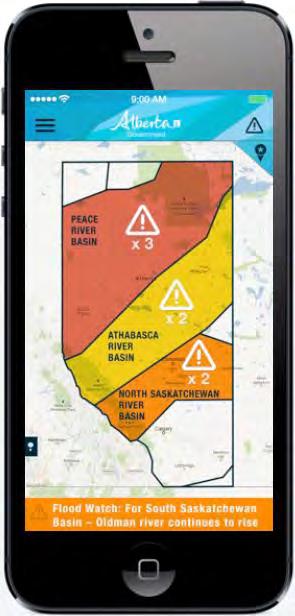
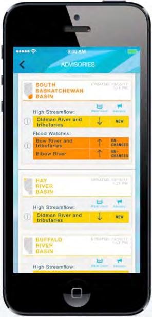
19 2014 Projects Cont d Communication Tools Improvement Current Tools Single Provincial Flood Advisory through Alberta Emergency Alerts Expanded content within the Forecasters Comments New Tool Alberta Rivers Mobile App (May 2014) Alberta Rivers

20 2014 Projects Cont d


21 2014 Projects Cont d


22 2014 Projects Cont d
23 Questions
Flood Forecasting Methodology in Alberta
 Flood Forecasting Methodology in Alberta Evan Friesenhan, M.Eng., P.Eng Alberta Environment and Sustainable Resource Development February 18, 2014 River Forecast Team Mandate To provide Albertans with
Flood Forecasting Methodology in Alberta
 Flood Forecasting Methodology in Alberta Evan Friesenhan, M.Eng., P.Eng Alberta Environment and Sustainable Resource Development March 17, 2014 River Forecast Team Mandate To provide Albertans with information
Challenges in providing effective flood forecasts and warnings
 Challenges in providing effective flood forecasts and warnings National Centre for Flood Research Inaugural Symposium Justin Robinson Bureau of Meteorology October 2018 Zero Lives Lost A key responsibility
Review of August 7, 2018 Storm Event
 Review of August 7, 2018 Storm Event Toronto and Region Conservation Authority August 10, 2018 Executive Committee Presented by: Dan Hipple, P.Eng. Senior Manager, Water Resources Engineering Chief Flood
FLOOD REPORT FOR MANITOBA. April 11, :00 am
 FLOOD REPORT FOR MANITOBA April 11, 2017 9:00 am Overland flooding and tributary flows are subsiding across much of southern Manitoba. Flows on northern rivers are ice covered and are responding to runoff.
Active Winter Weather Pattern February 4th-9th
 Active Winter Weather Pattern February 4th-9th Prepared 1230 PM EST Tuesday, February 4, 2014 Gary Szatkowski NOAA s NJ Forecast office http://www.erh.noaa.gov/phi/ Purpose of Briefing Briefing #6 Promote
United States Multi-Hazard Early Warning System
 United States Multi-Hazard Early Warning System Saving Lives Through Partnership Lynn Maximuk National Weather Service Director, Central Region Kansas City, Missouri America s s Weather Enterprise: Protecting
Flood Forecasting Tools for Ungauged Streams in Alberta: Status and Lessons from the Flood of 2013
 Flood Forecasting Tools for Ungauged Streams in Alberta: Status and Lessons from the Flood of 2013 John Pomeroy, Xing Fang, Kevin Shook, Tom Brown Centre for Hydrology, University of Saskatchewan, Saskatoon
NWS SERFC Hydrologic Vulnerability Assessment. Monday, March 9 th, 2015 NOAA, National Weather Service Southeast River Forecast Center
 NWS SERFC Hydrologic Vulnerability Assessment Monday, March 9 th, 2015 NOAA, National Weather Service Southeast River Forecast Center Current Weather Map Today s weather map shows a blossoming system in
Significant Coastal Storm Today through Thursday, 11/7-8. Weather Briefing
 Significant Coastal Storm Today through Thursday, 11/7-8 Weather Briefing Prepared 10:00 am EST Wednesday, November 7, 2012 Presented by Gary Conte, Warning Coordination Meteorologist NOAA s National Weather
Hydrological forecasting and decision making in Australia
 Hydrological forecasting and decision making in Australia Justin Robinson, Jeff Perkins and Bruce Quig Bureau of Meteorology, Australia The Bureau's Hydrological Forecasting Services Seasonal Forecasts
An Overview of Operations at the West Gulf River Forecast Center Gregory Waller Service Coordination Hydrologist NWS - West Gulf River Forecast Center
 National Weather Service West Gulf River Forecast Center An Overview of Operations at the West Gulf River Forecast Center Gregory Waller Service Coordination Hydrologist NWS - West Gulf River Forecast
FLOOD REPORT FOR MANITOBA. June 28, A Gale wind warning is in effect for Lake Manitoba and Lake Winnipeg
 FLOOD REPORT FOR MANITOBA June 28, 2014 A Gale wind warning is in effect for Lake Manitoba and Lake Winnipeg Flood Warning*: Flood Watch*: High Water Advisory*: - Assiniboine River, from Shellmouth Dam
IWT Scenario 2 Integrated Warning Team Workshop National Weather Service Albany, NY October 31, 2014
 IWT Scenario 2 Integrated Warning Team Workshop National Weather Service Albany, NY October 31, 2014 09 10 11 12 13 Scenario 2 Timeline December 9-13 Tue Wed Thu Fri Sat Tue, Dec. 9 @ 5 am 2014 2014 2014
Extreme Temperature Protocol in Middlesex-London
 Clean Air Partnership Webinar March 17, 2009 Extreme Temperature Protocol in Middlesex-London Presented by Iqbal Kalsi, MBA, CPHI(C), CCEP iqbal.kalsi@mlhu.on.ca 1 History Informal monitoring, tracking
DEVELOPMENT OF A FORECAST EARLY WARNING SYSTEM ethekwini Municipality, Durban, RSA. Clint Chrystal, Natasha Ramdass, Mlondi Hlongwae
 DEVELOPMENT OF A FORECAST EARLY WARNING SYSTEM ethekwini Municipality, Durban, RSA Clint Chrystal, Natasha Ramdass, Mlondi Hlongwae LOCATION DETAILS AND BOUNDARIES ethekwini Municipal Area = 2297 km 2
A Complex Weather System: Tuesday Afternoon into Thursday March 3 5, 2015
 A Complex Weather System: Tuesday Afternoon into Thursday March 3 5, 2015 Briefing #1, prepared 900 AM EST Tuesday, March 3, 2015 by Meteorologists at NWS - WFO Mount Holly, NJ To promote situational awareness
Nor easter Monday Night Wednesday December 8 10, 2014
 Nor easter Monday Night Wednesday December 8 10, 2014 Prepared 400 PM EST Monday, December 8, 2014 Mitchell Gaines NOAA s Philadelphia/Mount Holly NJ Forecast Office www.weather.gov/phi/ Purpose of Briefing
CLIMATE CHANGE ADAPTATION BY MEANS OF PUBLIC PRIVATE PARTNERSHIP TO ESTABLISH EARLY WARNING SYSTEM
 CLIMATE CHANGE ADAPTATION BY MEANS OF PUBLIC PRIVATE PARTNERSHIP TO ESTABLISH EARLY WARNING SYSTEM By: Dr Mamadou Lamine BAH, National Director Direction Nationale de la Meteorologie (DNM), Guinea President,
President s Day Weekend Storm Community Meeting and Workshop April 17, 2017
 President s Day Weekend Storm Community Meeting and Workshop April 17, 2017 Meeting outline 1. Progress update on the City of San Jose s recovery efforts 2. Water district presentation on: Weather situation
Complete Weather Intelligence for Public Safety from DTN
 Complete Weather Intelligence for Public Safety from DTN September 2017 White Paper www.dtn.com / 1.800.610.0777 From flooding to tornados to severe winter storms, the threats to public safety from weather-related
Exercise Brunswick ALPHA 2018
 ALPHA Exercise Brunswick ALPHA 2018 Who we are (our structure) What we do (our forecasts) How you can access the information Tropical cyclone information (basic) Overview of the products used for Exercise
NOAA s National Weather Service. National Weather Service
 NOAA s National Weather Service Serving the Nation s Environmental Forecasting Needs Lynn Maximuk Regional Director National Weather Service Central Region Headquarters Kansas City, Missouri America s
Operational Perspectives on Hydrologic Model Data Assimilation
 Operational Perspectives on Hydrologic Model Data Assimilation Rob Hartman Hydrologist in Charge NOAA / National Weather Service California-Nevada River Forecast Center Sacramento, CA USA Outline Operational
NWS Resources For Public Works
 NWS Resources For Public Works August 28th, 2016 Shawn DeVinny shawn.devinny@noaa.gov Meteorologist National Weather Service Twin Cities/Chanhassen, MN 1 APWA 2016 PWX 8/28/2016 National Weather Service
Early Warning > Early Action: The Next Frontier. Dr. Arame Tall Climate Services- Global Coordinator, Champion
 Early Warning > Early Action: The Next Frontier Dr. Arame Tall Climate Services- Global Coordinator, Champion a.tall@cgiar.org 2 3/21/11 The Challenge: Bridging The Gap Seasonal Precipitation Forecast
Overview of Early Warning Systems and the role of National Meteorological and Hydrological Services
 Overview of Early Warning Systems and the role of National Meteorological and Hydrological Services South Africa Second Experts Symposium on Multi-Hazard Early Warning Systems With focus on the Role of
Active Weather Threat Halloween Week Nor easter October 28 th 31 st 2012
 Active Weather Threat Halloween Week Nor easter October 28 th 31 st 2012 Prepared 1130 AM EDT Wednesday, October 24, 2012 Gary Szatkowski NOAA s NJ Forecast Office Weather.gov/phi Purpose of Briefing Briefing
OC Public Works El Niño Storm Preparation 2015
 OC Public Works El Niño Storm Preparation 2015 December 8, 2015 Overview About OC Public Works Storm Preparation Pre-Storm During Storm Post-Storm Storm Preparation Canyon and Burn Areas County Department
Speakers: NWS Buffalo Dan Kelly and Sarah Jamison, NERFC Jeane Wallace. NWS Flood Services for the Black River Basin
 Speakers: NWS Buffalo Dan Kelly and Sarah Jamison, NERFC Jeane Wallace NWS Flood Services for the Black River Basin National Weather Service Who We Are The National Oceanic and Atmospheric Administration
Rainfall-River Forecasting: Overview of NOAA s Role, Responsibilities, and Services
 Dr. Thomas Graziano Chief Hydrologic Services Division NWS Headquarters Steve Buan Service Coordination Hydrologist NWS North Central River Forecast Center Rainfall-River Forecasting: Overview of NOAA
Flash Flood Guidance System On-going Enhancements
 Flash Flood Guidance System On-going Enhancements Hydrologic Research Center, USA Technical Developer SAOFFG Steering Committee Meeting 1 10-12 July 2017 Jakarta, INDONESIA Theresa M. Modrick Hansen, PhD
SPEARFISH FIRE DEPARTMENT POLICIES AND PROCEDURES
 SPEARFISH FIRE DEPARTMENT POLICIES AND PROCEDURES Page 1 of 5 Volume: Operation Section: 20.00 Number: 20.09 Subject: Weather Watches, Warnings, Advisory s and Spotter Activation Date Issued: 28 March
Flood Indicators: Improving Forecasting in Alberta. Ryan Bjornsen, Alberta WaterSMART AI-EES Workshop: Alberta Flood Mitigation February 18, 2014
 Flood Indicators: Improving Forecasting in Alberta Ryan Bjornsen, Alberta WaterSMART AI-EES Workshop: Alberta Flood Mitigation February 18, 2014 Presentation Overview 1. Our Project - What, Why and How
UDOT Weather Program Traffic Operations Center
 UDOT Weather Program Traffic Operations Center Presentation Goals You MUST account for weather in your Traffic Management program Provide you with information on proven tools and strategies You NEED a
September 13, 2018 MEDIA RELEASE. Waynesboro Department of Emergency Management Waynesboro Police Department Waynesboro Fire Department
 MEDIA RELEASE September 13, 2018 The City continues to prepare for and monitor the track and potential impacts of Hurricane Florence. Current guidance from the National Weather Service, the National Hurricane
The UK Flood Forecasting Centre
 Storm Surge Networking Forum, Venice: Tuesday 19 th November 2013 The UK Flood Forecasting Centre Dave Cox - Senior Hydrometeorologist FFC Exeter, England. In My talk today I will cover: Ü Overview of
National Public Weather and Warning Services in the Swaziland Meteorological Service Dennis S.Mkhonta /
 National Public Weather and Warning Services in the Swaziland Meteorological Service Dennis S.Mkhonta dennis.mkhonta@gmail.com / dennis@swazimet.gov.sz Introduction Swaziland s geographical position exposes
Infrastructure and Expertise available to the Advisory Section
 Infrastructure and Expertise available to the Advisory Section By Lucky Nhlanhla Sigudla Advisory Section Outline INTRODUCTION STRUCTURE PRESENT INFRATUCTURE EXPERTISE SPECIFIC ISSUES USER ACTIVITIES CONCLUSION
IWT Scenario 1 Integrated Warning Team Workshop National Weather Service Albany, NY October 31, 2014
 Integrated Warning Team Workshop National Weather Service Albany, NY October 31, 2014 23 24 25 26 27 Scenario 1 Timeline November 23-27 Sun Mon Tue Wed Thu Thanksgiving Day Sunday, Nov. 23 @ 430 pm NWS
Winter Storm Saturday into Sunday December 14-15, 2013
 Winter Storm Saturday into Sunday December 14-15, 2013 Prepared 900 AM EST Friday December 13, 2013 Al Cope NOAA s NJ Forecast office http://www.erh.noaa.gov/phi/ Purpose of Briefing Briefing #3 for event.
Caribbean Early Warning System Workshop
 Caribbean Early Warning System Workshop Hamonization in Existing EWS April 14-16, 2016 Presenter: Shawn Boyce Caribbean Institute for Meteorology and Hydrology Husbands, St. James Barbados Background Between
Delaware River Flood Advisory Committee
 Delaware River Flood Advisory Committee A Partnership to Support Flood Mitigation Alan Tamm Pennsylvania Emergency Management Agency Bureau of Recovery and Mitigation atamm@state.pa.us Peter Gabrielsen
Republic of Mozambique
 Republic of Mozambique Second Expert's Symposium on Multi-Hazard Early Warning Systems with focus on the Role of National Meteorological and Hydrological Services 5-7 May 2009, Toulouse France 1. Background
Standard Operating Procedure
 Standard Operating Procedure Procedure: Emergency Weather Plan - Events Department/Division: Section: Date Originated: Culture & Recreation April 30, 2013 Approval: Approval: Date Revised: Reference: HUR130-016
Daily Operations Briefing. Saturday, March 3, :30 a.m. EST
 Daily Operations Briefing Saturday, March 3, 2018 8:30 a.m. EST Northeast Coastal Storm Situation A high-impact and long duration coastal storm is bringing area of heavy rain and snow, significant coastal
Weather Briefing Mixed Winter Storm Event February 26-27, 2013
 Weather Briefing Mixed Winter Storm Event February 26-27, 2013 Prepared 1200 PM EST Tuesday, February 26th, 2013 Joe Miketta NOAA s NJ Forecast Office http://www.erh.noaa.gov/phi/ Purpose of Briefing Briefing
Peterborough Distribution Inc Ashburnham Drive, PO Box 4125, Station Main Peterborough ON K9J 6Z5
 Peterborough Distribution Inc. 1867 Ashburnham Drive, PO Box 4125, Station Main Peterborough ON K9J 6Z5 November 15, 2017 Ontario Energy Board PO Box 2319 27 th Floor, 2300 Yonge St Toronto ON M4P 1E4
TXWARN Tabletop Exercise: Hurricane Helen
 TXWARN Tabletop Exercise: Hurricane Helen July 31, 2015 Administrative Details In-studio participants and remote participants Situation manual Evaluations Training hours 1 In Studio: Welcome and Introductions
Application of Satellite Data for Flood Forecasting and Early Warning in the Mekong River Basin in South-east Asia
 MEKONG RIVER COMMISSION Vientiane, Lao PDR Application of Satellite Data for Flood Forecasting and Early Warning in the Mekong River Basin in South-east Asia 4 th World Water Forum March 2006 Mexico City,
Sanjeev Kumar Jha Assistant Professor Earth and Environmental Sciences Indian Institute of Science Education and Research Bhopal
 Sanjeev Kumar Jha Assistant Professor Earth and Environmental Sciences Indian Institute of Science Education and Research Bhopal Email: sanjeevj@iiserb.ac.in 1 Outline 1. Motivation FloodNet Project in
Daily Operations Briefing Saturday, March 26, :30 a.m. EDT
 Daily Operations Briefing Saturday, March 26, 2016 8:30 a.m. EDT Significant Activity: March 25-26 Significant Events: None Significant Weather: Rain Pacific Northwest to Northern Intermountain; Southern
By Lillian Ntshwarisang Department of Meteorological Services Phone:
 By Lillian Ntshwarisang Department of Meteorological Services Phone: +267 3612200 Email: lntshwarisang@gov.bw/ lntshwarisang@gmail.com Introduction Mandate of DMS Function of the Department Services to
Weather forecasts and warnings: Support for Impact based decision making
 Weather forecasts and warnings: Support for Impact based decision making Gerry Murphy, Met Éireann www.met.ie An Era of Change Climate and weather is changing Societal vulnerability is increasing The nature
Robert Shedd Northeast River Forecast Center National Weather Service Taunton, Massachusetts, USA
 Robert Shedd Northeast River Forecast Center National Weather Service Taunton, Massachusetts, USA Outline River Forecast Centers FEWS Implementation Status Forcing Data Ensemble Forecasting The Northeast
Briefing on the WMO Support to Viet Nam to cope with Typhoon Haiyan
 WMO Briefing on the WMO Support to Viet Nam to cope with Typhoon Haiyan A Case of WMO Emergency Response Typhoon Haiyan trajectory Background Typhoon Haiyan remained strong after devastating the Philippines
Daily Operations Briefing Sunday, January 8, :30 a.m. EST
 Daily Operations Briefing Sunday, January 8, 2017 8:30 a.m. EST Significant Activity Jan 6-8 Significant Events: Heavy Precipitation forecast to impact CA and NV Significant Weather: Freezing rain Pacific
NWS Resources For School Districts
 NWS Resources For School Districts January 23rd, 2017 Shawn DeVinny shawn.devinny@noaa.gov Meteorologist National Weather Service Twin Cities/Chanhassen, MN Outline Watches/Warnings/Advisories Example
Moisture Situation Update November 6, 2016
 Synopsis October 2016, was unseasonably cool and wet across most of the province. This was particularly true for lands north of the Yellowhead Highway, as well as many other areas, west of Highway 2, stretching
Nurture Nature Center Receives Grant From National Oceanic and Atmospheric Administration To Study Flood Forecast and Warning Tools
 Nurture Nature Center Receives Grant From National Oceanic and Atmospheric Administration To Study Flood Forecast and Warning Tools One of four national awards by National Weather Service to advance weather
An overview of the applications for early warning and mapping of the flood events in New Brunswick
 Flood Recovery, Innovation and Reponse IV 239 An overview of the applications for early warning and mapping of the flood events in New Brunswick D. Mioc 1, E. McGillivray 2, F. Anton 1, M. Mezouaghi 2,
Hurricane Sandy October 28 th 31 st 2012
 Hurricane Sandy October 28 th 31 st 2012 Prepared 530 PM EDT Saturday October 27, 2012 Gary Szatkowski NOAA s NJ Forecast Office Weather.gov/phi Purpose of Briefing Briefing #7 for event Promote situational
Charles Kuster Leadville, CO. Personal Overview
 Charles Kuster Leadville, CO Personal Overview Personal Overview Charles Kuster Leadville, CO OU to study meteorology Charles Kuster Leadville, CO Personal Overview OU to study meteorology Graduated in
Forecasting Flood Risk at the Flood Forecasting Centre, UK. Delft-FEWS User Days David Price
 Forecasting Flood Risk at the Flood Forecasting Centre, UK Delft-FEWS User Days 2012 David Price Overview of the Flood Forecasting Centre (FFC) What is the FFC? Partnership between the Met Office and Environment
CoCoRaHS. Community Collaborative Rain, Hail, & Snow Network. Ashley Wolf Meteorologist NWS Green Bay Northeast Wisconsin CoCoRaHS Coordinator
 CoCoRaHS Community Collaborative Rain, Hail, & Snow Network Ashley Wolf Meteorologist NWS Green Bay Northeast Wisconsin CoCoRaHS Coordinator What is CoCoRaHS Who, What, Where and Whys of CoCoRaHS What?
Minnesota s Runoff Risk Advisory Forecast
 Minnesota s Runoff Risk Advisory Heather Johnson Hydrologist 3 October 16, 2018 What is Runoff Risk? The Minnesota Runoff Risk Advisory (RRAF) system is a website tool designed to help farmers and commercial
Summary of the 2017 Spring Flood
 Ottawa River Regulation Planning Board Commission de planification de la régularisation de la rivière des Outaouais The main cause of the exceptional 2017 spring flooding can be described easily in just
Daily Operations Briefing Monday, March 30, :30 a.m. EDT
 Daily Operations Briefing Monday, March 30, 2015 8:30 a.m. EDT Significant Activity: Mar 27 30 Significant Events: Pacific earthquakes; no tsunami Significant Weather: Snow Upper Great Lakes and Northern
ECCC/CCMEP variable resolution modelling of the Hudson Bay watershed
 ECCC/CCMEP variable resolution modelling of the Hudson Bay watershed Vincent Fortin (and many collaborators) Division de la recherche en météorologie Environnement en Changement climatique Canada GEM-based
Severe Storm Response Version # 1-0-1
 Severe Storm Response Version # 1-0-1 Weather Warnings Environment Canada issues severe weather warnings, watches and advisories Weather Watch Severe weather may develop. Weather Warning Severe weather
Issued by: National Weather Service San Joaquin Valley - Hanford CA. Issue time: 409 AM PST Wed Jan
 Forecast Information Location: New_Exchequer_Dam Updated: January 16, 2019, 11:45 am NWS Weather Discussion: Issued by: National Weather Service San Joaquin Valley - Hanford CA Issue time: 409 AM PST Wed
Weather briefing Strong Coastal Nor easter November 7 th -8 th, 2012
 Weather briefing Strong Coastal Nor easter November 7 th -8 th, 2012 Prepared 1245 PM EDT Tuesday November 6, 2012 Gary Szatkowski NOAA s NJ Forecast Office Weather.gov/phi Purpose of Briefing Briefing
Using Operating Experience to Prevent or Mitigate Nuclear Events. What Is, Was and Will Be Available
 Using Operating Experience to Prevent or Mitigate Nuclear Events What Is, Was and Will Be Available Introduction Remember, it is by understanding the lessons learned from past events that we can adequately
Regional Flash Flood Guidance and Early Warning System
 WMO Training for Trainers Workshop on Integrated approach to flash flood and flood risk management 24-28 October 2010 Kathmandu, Nepal Regional Flash Flood Guidance and Early Warning System Dr. W. E. Grabs
Missouri River Basin Water Management
 Missouri River Basin Water Management US Army Corps of Engineers Missouri River Navigator s Meeting February 12, 2014 Bill Doan, P.E. Missouri River Basin Water Management US Army Corps of Engineers BUILDING
HURRICANE MATTHEW A GIS PERSPECTIVE GLYNN COUNTY GIS
 HURRICANE MATTHEW A GIS PERSPECTIVE GLYNN COUNTY GIS Situation September 25 th October 9 th 2016 Hurricane Matthew tracked its way up the east coast bringing hurricane force winds and flooding from Haiti
C o p e r n i c u s E m e r g e n c y M a n a g e m e n t S e r v i c e f o r e c a s t i n g f l o o d s
 C o p e r n i c u s E m e r g e n c y M a n a g e m e n t S e r v i c e f o r e c a s t i n g f l o o d s Copernicus & Copernicus Services Copernicus EU Copernicus EU Copernicus EU www.copernicus.eu W
Results of Intensity-Duration- Frequency Analysis for Precipitation and Runoff under Changing Climate
 Results of Intensity-Duration- Frequency Analysis for Precipitation and Runoff under Changing Climate Supporting Casco Bay Region Climate Change Adaptation RRAP Eugene Yan, Alissa Jared, Julia Pierce,
Appendix A Flood Damages in 2013
 Appendix A Flood Damages in 2013 RPT2-2014-07-09-App_A_Highwood_River_Flood_Damage_In_2013.Docx Table of Contents page Sign-Off 1. Flood Damage in 2013... 1 1.1 Background... 1 1.2 Town of High River...
Very Dangerous Coastal Storm Sandy October 28 th 31 st 2012
 Very Dangerous Coastal Storm Sandy October 28 th 31 st 2012 Prepared 600 PM EDT Monday October 29, 2012 Gary Szatkowski NOAA s NJ Forecast Office Weather.gov/phi Purpose of Briefing Briefing #11 for event
Multihazard Early Warning Systems: The European Meteoalarm Platform
 Multihazard Early Warning Systems: The European Meteoalarm Platform UN - ISDR Sendai Framework of Actions, 2015 Early warning criteria: users To develop and strengthen: people-centred multi-hazard forecasting
Weather Information for Surface Transportation (WIST): Update on Weather Impacts and WIST Progress
: Update on Weather Impacts and WIST Progress") Weather Information for Surface Transportation (WIST): Update on Weather Impacts and WIST Progress Samuel P. Williamson Office of the Federal Coordinator for Meteorological Services and Supporting Research
Weather Information for Surface Transportation (WIST): Update on Weather Impacts and WIST Progress Samuel P. Williamson Office of the Federal Coordinator for Meteorological Services and Supporting Research
Arkansas-Red Basin River Forecast Center Operations. RRVA Conference Durant, OK 8/22/2013 Jeff McMurphy Sr. Hydrologist - ABRFC
 Arkansas-Red Basin River Forecast Center Operations RRVA Conference Durant, OK 8/22/2013 Jeff McMurphy Sr. Hydrologist - ABRFC NWS River Forecast Centers NWS Weather Forecast Offices Operations Staffing
The Kentucky Mesonet: Entering a New Phase
 The Kentucky Mesonet: Entering a New Phase Stuart A. Foster State Climatologist Kentucky Climate Center Western Kentucky University KCJEA Winter Conference Lexington, Kentucky February 9, 2017 Kentucky
Monitoring Extreme Weather Events. February 8, 2010
 Monitoring Extreme Weather Events February 8, 2010 Extensive network of over 800 stations across the Prairies Good coverage across entire agriculture production region Network of networks strategy includes
Areal Reduction Factors for the Colorado Front Range and Analysis of the September 2013 Colorado Storm
 Areal Reduction Factors for the Colorado Front Range and Analysis of the September 2013 Colorado Storm Doug Hultstrand, Bill Kappel, Geoff Muhlestein Applied Weather Associates, LLC - Monument, Colorado
NATIONAL WEATHER SERVICE
 January 2016 February 9, 2016 This was a dry month across the HSA despite one large and several smaller snowfalls. Most locations ended up 1-2 inches below normal for the month. The driest locations at
Daily Operations Briefing Thursday, January 8, :30 a.m. EST
 Daily Operations Briefing Thursday, January 8, 2015 8:30 a.m. EST Significant Activity: Jan 7-8 Significant Events: None Significant Weather: Snow Northern Rockies to Central Plains; Upper Mississippi
A HURRICANE IS COMING. Presented by Atiba Upchurch Broward Emergency Management Division
 A HURRICANE IS COMING Presented by Atiba Upchurch Broward Emergency Management Division Mission Statement To safeguard the lives and property of the people of Broward County from major hazards and emergencies
Weather Briefing. Coastal Storm Monday-Wednesday Dec 8-10, National Weather Service. Prepared 12/8/14 6:30 AM
 Weather Briefing Coastal Storm Monday-Wednesday Dec 8-10, 2014 National Weather Service http://www.weather.gov/nyc Prepared 12/8/14 6:30 AM Overview of Potential Hazards A strong low pressure system will
ÖBB Natural Hazard Management
 ÖBB Natural Hazard Management Management of Weather Events in the Austrian Federal Railways MOWE-IT, Brussels 17 th of September 2013 DI Günther Kundela Integrated Track Management Integration Technic
Adaptation by Design: The Impact of the Changing Climate on Infrastructure
 Adaptation by Design: The Impact of the Changing Climate on Infrastructure Heather Auld, J Klaassen, S Fernandez, S Eng, S Cheng, D MacIver, N Comer Adaptation and Impacts Research Division Environment
Areal Reduction Factors for the Colorado Front Range and Analysis of the September 2013 Colorado Storm
 Areal Reduction Factors for the Colorado Front Range and Analysis of the September 2013 Colorado Storm Doug Hultstrand, Bill Kappel, Geoff Muhlestein Applied Weather Associates, LLC - Monument, Colorado
ICE STORM! a mini tabletop exercise for home care agencies
 1 ICE STORM! a mini tabletop exercise for home care agencies HCA Education and Research Winter 2010 2011 2 What is a tabletop exercise? People come together to review and discuss a hypothetical emergency
1 City of Edmonton Quesnell Bridge, Roads and Associated Structures Assessment
 1 City of Edmonton Quesnell Bridge, Roads and Associated Structures Assessment 1.1 Background Within the First National Engineering Vulnerability Assessment, the Public Infrastructure Engineering Vulnerability
Responsive Traffic Management Through Short-Term Weather and Collision Prediction
 Responsive Traffic Management Through Short-Term Weather and Collision Prediction Presenter: Stevanus A. Tjandra, Ph.D. City of Edmonton Office of Traffic Safety (OTS) Co-authors: Yongsheng Chen, Ph.D.,
Weather briefing Strong Coastal Nor easter November 7 th -8 th, 2012
 Weather briefing Strong Coastal Nor easter November 7 th -8 th, 2012 Prepared 1215 PM EDT Wednesday November 7, 2012 Gary Szatkowski NOAA s NJ Forecast Office http://www.erh.noaa.gov/phi/ Purpose of Briefing
Southern California Edison ESRB-8 Report Regarding Pro-Active De-Energization Event December 29 to January 1, 2019
 Southern California Edison Submitted to: California Public Utilities Commission Director of the Safety and Enforcement Division January 15, 2019 Southern California Edison (SCE) submits the following report
Daily Operations Briefing. Sunday, March 16, :30 a.m. EDT
 Daily Operations Briefing Sunday, March 16, 2014 8:30 a.m. EDT Significant Activity: Mar 15 16 Significant Events: Winter Storm Ohio Valley to Mid-Atlantic M 4.0 earthquake near Anthony, Kansas Significant
MARFC Sandy Briefing. NWS Middle Atlantic River Forecast Center 11am Monday Oct 29, 2012
 MARFC Sandy Briefing NWS Middle Atlantic River Forecast Center 11am Monday Oct 29, 2012 Key Message Continue to monitor http://water.weather.gov for frequent updates to river forecasts. storm is underway