Archaeological Heritage Impact Assessment
|
|
|
- Hector Jefferson
- 5 years ago
- Views:
Transcription
1 Archaeological Heritage Impact Assessment Remainder Portion 54 of the Farm Hooge Kraal 238, Magisterial District George, Western Cape Province: proposed development of a small, Eco Friendly and environmentally sustainable Health Spa Lekala Eco Tourism Management (Pty) Ltd Ms Karen Waterson P.O. Box 2343, Brooklyn Square, , karenw@lekalaeco.co.za by Centre for Heritage and Archaeological Resource Management cc C H A R M cc Dr. Peter Nilssen PO Box 176, Great Brak River, ; ; peter@carm.co.za Company No. CK 2006\133900\23 VAT No April 2008
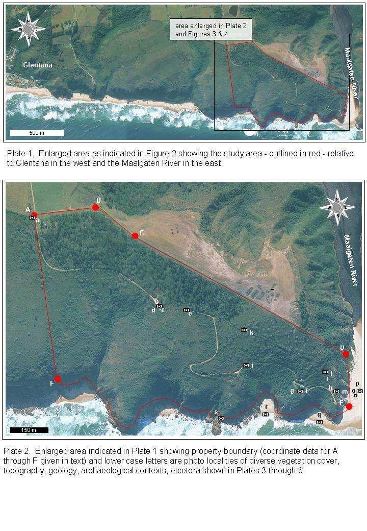
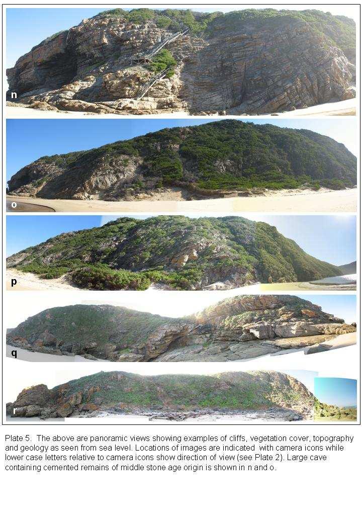
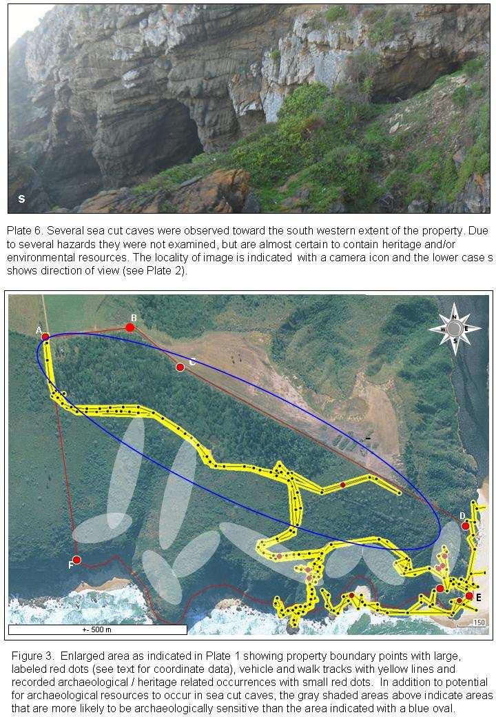
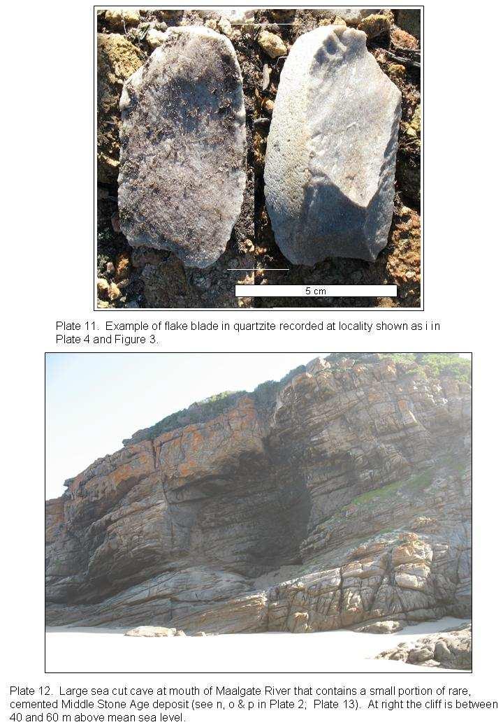
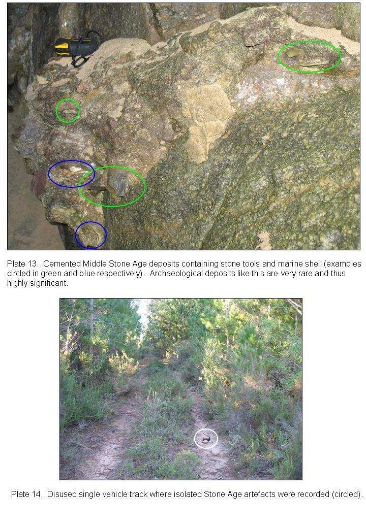
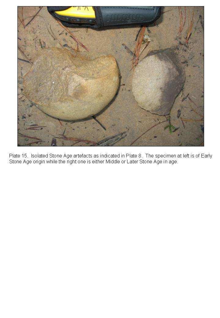
2 Executive Summary On 5 July and 31 August 2007 an archaeological impact scoping survey was undertaken by CHARM cc as commissioned by Karen Waterston of Lekala Eco Tourism Management (PTY) LTD on Remainder Portion 54 of the Farm Hoogekraal 238, George, Western Cape Province (Figures 1 & 2 and Plates 1 & 2). The main limitations to the study included restricted access due to topography and large areas of the property are covered with impenetrable vegetation and even where vegetation is low and less dense, only a small portion of the ground surface is visible for detection of archaeological traces. Nevertheless, nine archaeological occurrences were recorded including materials spanning the bulk of the Stone Age from at least half a million years ago up to the last several hundred years. No archaeological material of the pottery / pastoralist (from about 2000 to a few hundred years ago) or colonial period (the last 400 years or so) were observed. The archaeological occurrence shown in Plates 12 and 13 is of significant value as similar deposits are very rare and represent the time period when anatomically and behaviorally modern humans emerged. The above results of the limited scoping survey provide compelling evidence that the property is archaeologically sensitive. Due to the limitations described above, a full Heritage Archaeological Impact Assessment is not possible at this time and since development will be restricted to selected, environmentally non-sensitive nodes, the following is recommended: After finalizing layout of development, conduct a full Archaeological Impact Assessment (AIA) of all development nodes at the time of and after vegetation clearing when ground surfaces are exposed and during all earthmoving activities. Propose and motivate that an AIA of the entire property is not possible and that Heritage Western Cape accept and approve a node -based AIA as detailed above - on condition that any additional or future development (vegetation clearing and earthmoving activities) on the property is subject to an AIA of the affected areas. If the development goes ahead, then a conservation and management plan will be required for important archaeological sites and occurrences such as that shown in Plates 12 and 13. Since a variety of archaeological materials occur on the property, a display and brief narrative concerning such materials will make an interesting and valuable contribution to the development. 2
3 Table of Contents Content Page Executive Summary 2 1. Introduction Background Purpose of the Study Study Area Approach to the Study 5 2. Results 6 3. Sources of Risk, Impact Identification, Assessment and Recommendation 6 4. Reference 7 Figures and Plates. 7 3
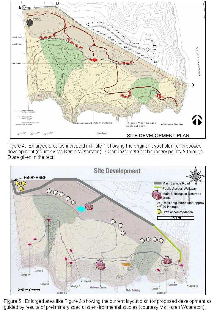
4 1. Introduction 1.1 Background The property in question is owned by Mrs Plattner of Fancourt who wishes to develop a small, exclusive spa. Being proactive, Mrs Plattner appointed Lekala Eco Tourism Management (Pty) Ltd to undertake a Preliminary Sensitivity Analysis on the property to establish the feasibility of development, and to guide its nature, placement and extent. Ms Karen Waterston of Lekala Eco Tourism Management (Pty) Ltd appointed the Centre for Heritage and Archaeological Resource Management (CHARM cc) to conduct an Archaeological Heritage Impact Assessment (AHIA) on Remainder Portion 54 of the Farm Hooge Kraal 238, Magisterial District George, Western Cape Province (Figures 1 & 2 and Plates 1 & 2). Ms Waterston, based on Tim Hart s recommendations, decided to include a preliminary Archaeological study at this point, even though the Fynbos is very dense and difficult to access. The developer s intention is that results of specialist environmental studies guide and mold the nature and layout of development. The development must avoid or minimize adverse impact on sensitive and endangered environmental resources. Preliminary layout plans for the proposed development are shown in Figures 4 and 5 and include; Main service road; Public access walkway; Main buildings in disturbed areas; Wellness centre; About 20 units and/or lodges; 2 lookout points; and Staff accommodation Purpose and Scope of the Study Objectives of the Archaeological Heritage Impact Assessment are: To assess the study area for traces of archaeological and heritage-related materials; To identify options for mitigation in order to minimize potential negative impacts; and To make recommendations for mitigation. Terms of Reference (ToR): a) Locate boundaries of the study area. b) Conduct a foot survey of the study area to identify and record archaeological and heritagerelated resources. c) Assess the impact of the proposed development on archaeological and heritage-related materials. d) Recommend mitigation measures where necessary. e) Prepare and submit report to Ms Karen Waterson of Lekala Eco Tourism Management (Pty) Ltd that meets standards required by Heritage Western Cape in terms of the National Heritage Resources Act, No. 25 of Study Area Remainder Portion 54 of Farm Hooge Kraal 238, Magisterial District George, Western Cape Province is situated on the coast immediately west of the Maalgaten River, around 4 km - straight line - east of the coastal holiday village of Glentana, and an approximately 13 km crow flight south west of George (Figures 1 & 2 and Plates 1 & 2). From Mossel Bay, the 4
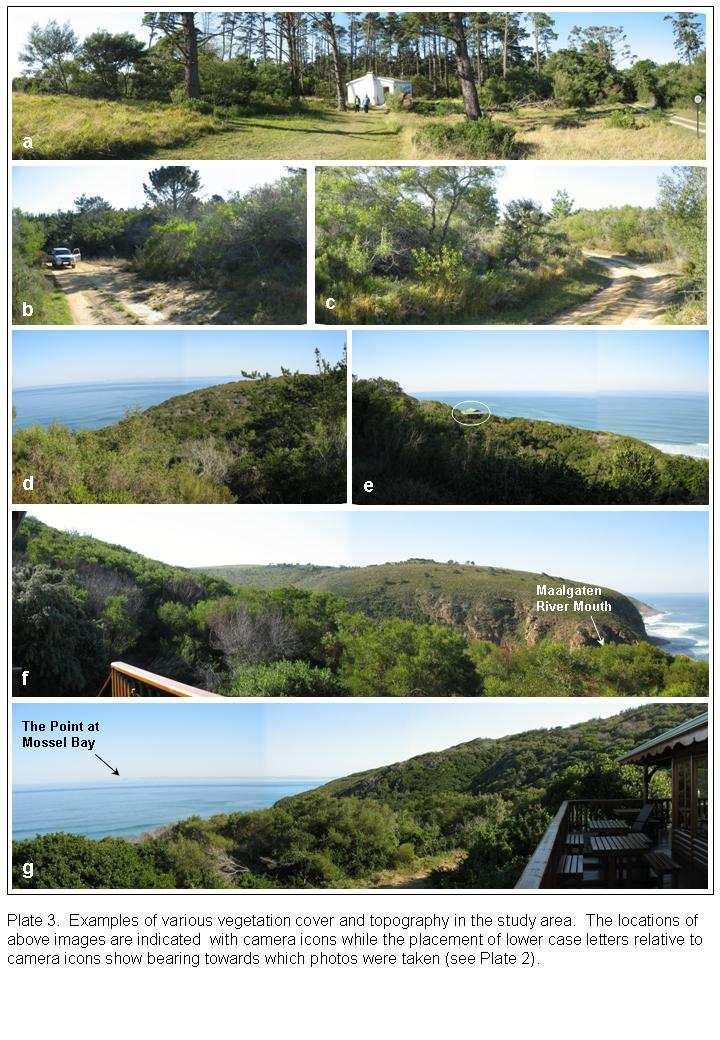
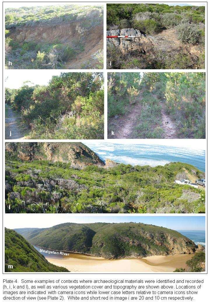
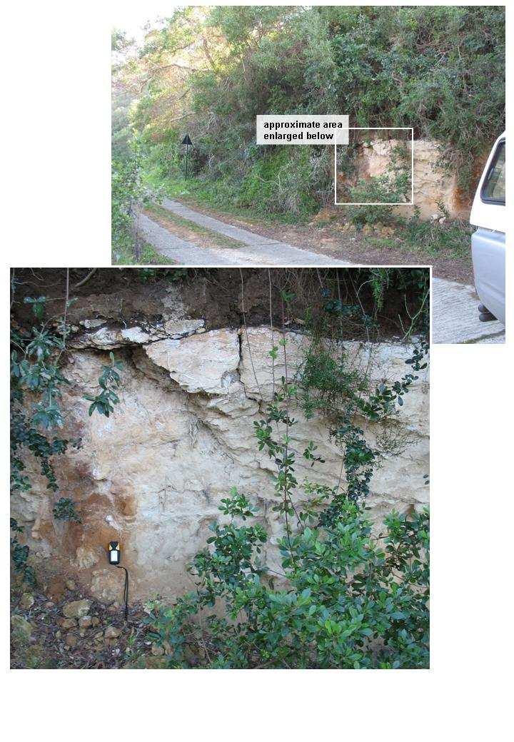
5 study area was reached by vehicle by taking the Glentana exit from the N2, turning right at the end of the off ramp, and finally turning left onto an unpaved road for the last 4 km to the study area. The access route is indicated with red arrows in Figure 2. The study area is hectares in extent, and its main boundary points - rounded to the nearest meter - are as follows (map datum WGS 84; see Plate 2): A, S E (decimal degrees); 23 Y X (SA Grid) B, S E (decimal degrees); 23 Y X (SA Grid) C, S E (decimal degrees); 23 Y X (SA Grid) D, S E (decimal degrees); 23 Y X (SA Grid) E, S E (decimal degrees); 23 Y X (SA Grid) F, S E (decimal degrees); 23 Y X (SA Grid) Plates 2 through 6 show diverse vegetation cover, topography, geology, and examples of contexts where archaeological and heritage related resources were identified. See Jones and Patton (2007) for preliminary descriptions, assessments and concerns regarding environmental and related aspects including, but not restricted to; interested and affected parties geology, geotechnical or engineering geological aspects, soils and associated flora, soils and land capability, geohydrology and groundwater, soil erodibility, soil utilization potential, land use topography natural vegetation animal life surface water, water use, water authority sensitive landscapes visual aspects air quality 1.4 Approach to the Study To the best of our knowledge, no archaeological or heritage related work has been conducted on the affected property or in its immediate vicinity. Numerous and varied archaeological sites - mostly of Stone Age origin have been identified through impact assessments (Kaplan, Hart, Halkett, Mutti, Marean, this author) and recreational hiking along the coastal strip from Mossel Bay to Herolds Bay and include open air sites and archaeological resources in caves / rock shelters. On 5 July and 31 August 2007 a preliminary archaeological heritage impact assessment of the affected property was undertaken by this author as commissioned by Ms Karen Waterston of Lekala Eco Tourism Management (PTY) LTD. The study area was reached and accessed by vehicle with the aid of maps, aerial photos and coordinate data provided by Ms Waterston (Figure 2). The main limitations to the study included inaccessibility to the south western portion of the property due to very steep to vertical topography along the coastal cliffs, and the bulk of the study area is covered with impenetrable vegetation and even where vegetation is low and less dense, only a small portion of the ground surface is visible for detection of archaeological traces (Plates 2 through 6). Consequently, the vehicle and foot survey was restricted to vehicle tracks, exposed geological profiles of road/track cuttings, previously disturbed areas around cottage and eastern extent of vehicle track, exposed surfaces of and 5
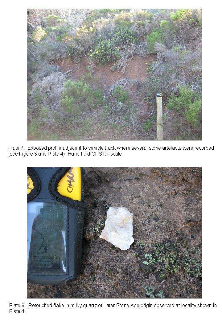
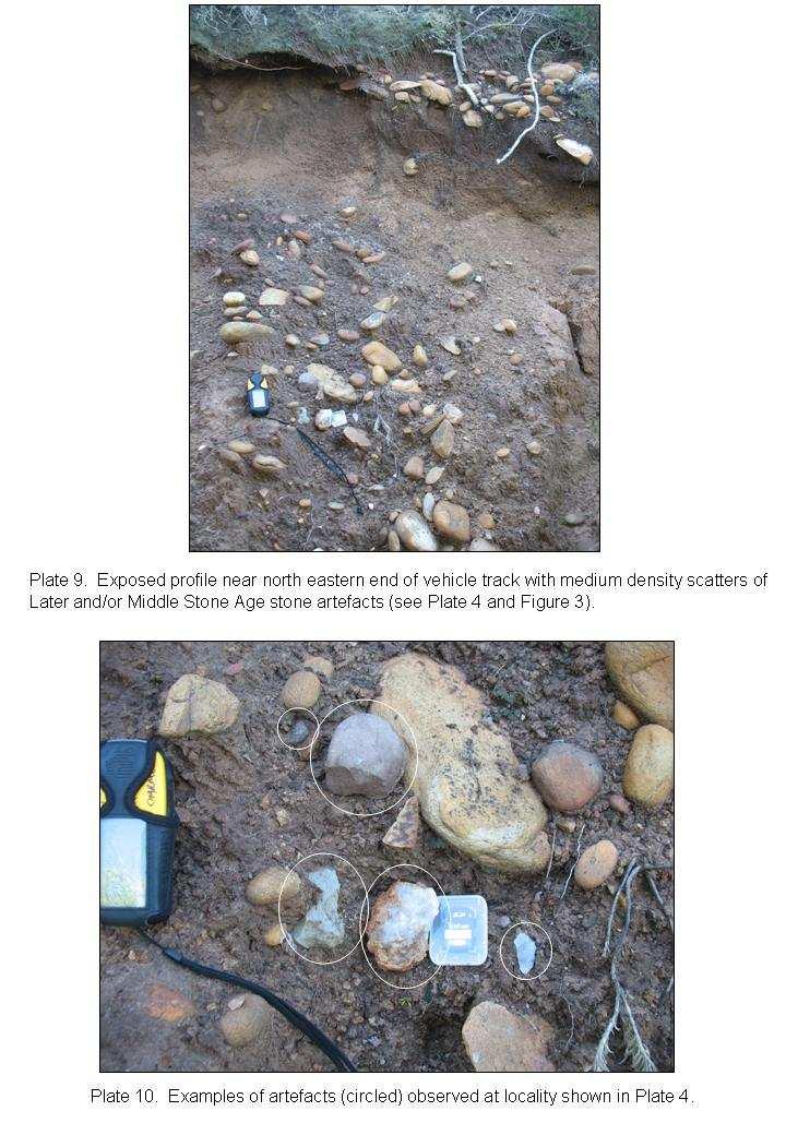
6 around rocky outcrops, and accessible portions along and at the base of the coastal cliffs (Plates 2 through 6). Records of the search include data fixed with a hand held GPS including vehicle and pedestrian trails, an assessment of the viability of the survey with respect to accessibility, vegetation and visibility, notes on the materials found as well as their contexts, a GPS fix and digital photography (a comprehensive photographic record is available from the author). Any archaeological heritage located during the survey was assessed in terms of its significance and scale of importance as well as in terms of the potential impacts of the proposed development. Given the limitations in the study area regarding visibility and accessibility, this report estimates that the survey captured less than adequate information on the archaeological heritage present. Due to limitations and restrictions mentioned above, this survey provides only a preliminary window on archaeological and heritage related resources in the study area. 2. Results The vehicle and foot survey covered a distance of 8.8 km while inspection of exposed ground surfaces was limited to an area of roughly 7.7 hectares (Figures 3). Nevertheless, nine archaeological occurrences were recorded including materials originating in the Early Stone Age (around years before present and older), Middle Stone Age (from to about years ago) and Later Stone Age (from some to several hundred years ago). See examples and contexts of observations in Figure 3 and Plates 4, 5, 7 through 15. No archaeological material of the pottery / pastoralist (from about 2000 to a few hundred years ago) or colonial period (the last 400 years or so) were observed, but this may be a function of the limitations described above. The archaeological occurrence shown in Plates 12 and 13 is of significant value as similar deposits are very rare and represent the time period when anatomically and behaviorally modern humans emerged. Figure 3 shows that several of the identified archaeological occurrences are located within a certain range or belt of contours, and it is likely that this pattern will continue in areas not accessible at the time of conducting the survey. All archaeological and heritage related artefacts identified on the property are protected by the National Heritage Resources Act no. 25 of These materials may in no way be removed or disturbed without a permit from Heritage Western Cape. 3. Sources of Risk, Impact Identification, Assessment and Recommendation The developer s intention is that results of specialist environmental studies guide and mold the nature and layout of development. The development must avoid or minimize adverse impact on sensitive and endangered environmental resources. Preliminary layout plans for the proposed development are shown in Figures 4 and 5 and include; Main service road; Public access walkway; Main buildings in disturbed areas; Wellness centre; About 20 units and/or lodges; 2 lookout points; and Staff accommodation. 6
7 In addition, the negative impact of pedestrian traffic increase with development - on archaeological resources should not be underestimated. The above results of the limited scoping survey provide compelling evidence that the property is archaeologically sensitive. Due to the limitations described above, a full Heritage Archaeological Impact Assessment is not possible at this time and since development will be restricted to selected, environmentally non-sensitive nodes, the following is recommended: After finalizing layout of development, conduct a full Archaeological Impact Assessment (AIA) of all development nodes at the time of and after vegetation clearing when ground surfaces are exposed and during all earthmoving activities. Propose and motivate that an AHIA of the entire property is not possible and that Heritage Western Cape accept and approve a node -based AIA as detailed above - on condition that any additional or future development (vegetation clearing and earthmoving activities) on the property is subject to an AHIA of the affected areas. If the development goes ahead, then a conservation and management plan will be required for important archaeological sites and occurrences such as that shown in Plates 12 and 13. Since a variety of archaeological materials occur on the property, a display and brief narrative concerning such materials will make an interesting and valuable contribution to the development. 4. Reference Ian Jones and Phil Patton Glentana Fancourt Development: Pre Application (EIA) Site Investigation. Draft Report v1.1 Compiled by Earth Science Solutions for Lekala Eco (PTY) LTD Figures and Plates (on following pages) 7

8 8
9 9
10 10
11 11
12 12
13 13
14 14
15 15
16 16
17 17
18 18
19 19
20 20
2017/03/31. Figure 9. British military graveyard at Fort Cox. Figure 10. Memorial stone. HIA: Fort Cox College Water and Sanitation Services
 2017/03/31 Figure 9. British military graveyard at Fort Cox Figure 10. Memorial stone 22 2017/03/31 Figure 11. Memorial stone Previous Studies An extensive research into the SAHRIS database resulted in
Seaton to Seaton Hole SUMMARY OF PREFERRED PLAN RECOMMENDATIONS AND JUSTIFICATION
 Location reference: Policy Unit reference: Plan: Seaton to Seaton Hole 6a29 and 6a30 SUMMARY OF PREFERRED PLAN RECOMMENDATIONS AND JUSTIFICATION The large number of properties and assets at risk in the
Environmental Scoping Report for the proposed establishment of a New Coal-Fired Power Station in the Lephalale Area, Limpopo Province
 12. ARCHAEOLOGICAL AND HERITAGE RESOURCES The National Cultural History Museum was contracted by Bohlweki Environmental to survey an area in which it is proposed to re-align an existing road and construct
ACTON COMMUNITY WIDE ARCHAEOLOGICAL RECONNAISSANCE SURVEY. Town of Acton and PAL, Inc.
 ACTON COMMUNITY WIDE ARCHAEOLOGICAL RECONNAISSANCE SURVEY Town of Acton and PAL, Inc. Objectives and Scope of Work Four phase study; (1. research, 2. draft report outline, resource protection bylaw, 3.
DESKTOP PALAEONTOLOGICAL IMPACT ASSESSMENT. Bloemhof Extensions 11, 12 and 13 Township development in Lekwa-Teemane Local Municipality
 DESKTOP PALAEONTOLOGICAL IMPACT ASSESSMENT Bloemhof Extensions 11, 12 and 13 Township development in Lekwa-Teemane Local Municipality Specialist report by: Bruce Rubidge Address: PO Box 85346 Emmarentia
11 PALAEONTOLOGY, ARCHAEOLOGY AND CULTURAL HERITAGE IMPACTS
 11 PALAEONTOLOGY, ARCHAEOLOGY AND CULTURAL HERITAGE IMPACTS This chapter discusses the potential impacts on palaeontology, archaeology and cultural heritage resources resulting from the establishment of
Comprehensive and Professional Solutions for all Heritage Related Matters CK 2006/014630/23 VAT NO.:
 P.O.BOX73703 LYNNWOOD RIDGE 0040 Tel: 083 459 3091 Fax: 086 695 7247 Email: pelseranton@gmail.com Comprehensive and Professional Solutions for all Heritage Related Matters CK 2006/014630/23 VAT NO.: 4360226270
Initial Gold Resource at Sissingue Tengrela Project (Ivory Coast)
") ASX/MEDIA RELEASE 27 November 2008 Highlights Initial Gold Resource at Sissingue Tengrela Project (Ivory Coast) Indicated and Inferred resources total 970,000 ounces at 1.9 using 1 cut-off (15.7 million
ASX/MEDIA RELEASE 27 November 2008 Highlights Initial Gold Resource at Sissingue Tengrela Project (Ivory Coast) Indicated and Inferred resources total 970,000 ounces at 1.9 using 1 cut-off (15.7 million
Construction Exits Rock pads
 Construction Exits Rock pads SEDIMENT CONTROL TECHNIQUE Type 1 System Sheet Flow Sandy Soils Type 2 System Concentrated Flow [1] Clayey Soils Type 3 System Supplementary Trap Dispersive Soils [1] Minor
Unit 7.2 W.E.D. & Topography Test
 Name: Score: Unit 7.2 W.E.D. & Topography Test 1. 2. 3. 4. 5. 6. 7. 8. 9. 10. 11. 12. 13. 14. 15. 16. 17. 18. 19. 20. 21. 22. 23. 24. 25. 1. The formation of mountains is due mainly to while the destruction
Pierce Cedar Creek Institute GIS Development Final Report. Grand Valley State University
 Pierce Cedar Creek Institute GIS Development Final Report Grand Valley State University Major Goals of Project The two primary goals of the project were to provide Matt VanPortfliet, GVSU student, the
Report on Geophysical Survey Na Vrsku, Sahy, Slovakia Coordinates: 48⁰,4,45 N 18⁰,56,23 E. April 2018
 Report on Geophysical Survey Na Vrsku, Sahy, Slovakia Coordinates: 48⁰,4,45 N 18⁰,56,23 E April 2018 Mark Graham BA(Hons), BSc, MA Grampus Heritage and Training Ltd, Ashgill, Threapland, Wigton, Cumbria,
Guidance for implementing the Potential Fossil Yield Classification (PFYC) System
 System") Guidance for implementing the Potential Fossil Yield Classification (PFYC) System Introduction The PFYC system will aid in assessing the potential to discover or impact significant paleontological resources.
Guidance for implementing the Potential Fossil Yield Classification (PFYC) System Introduction The PFYC system will aid in assessing the potential to discover or impact significant paleontological resources.
Acrefield Cottage, Winkfield Street, Maidens Green, Winkfield, Windsor, Berkshire
 Acrefield Cottage, Winkfield Street, Maidens Green, Winkfield, Windsor, Berkshire An Archaeological Watching Brief For Mr and Mrs Elia by Pamela Jenkins Thames Valley Archaeological Services Ltd Site Code
CHAPTER 7 GEOLOGY AND SOILS
 CHAPTER 7 GEOLOGY AND SOILS 7.1 General Geology of the Area Based on the Geological map compiled by Cornec (2002) the area consists of Miocene/Pleistocene deposits as seen in figure 7.1. These are geologically
Plate 51. Site 035. Collection of remains. Scale is in cm. Plate 50. Site 034. Collection of remains. Scale is in cm
 Plate 48. Site 033. View facing north west Plate 49. Site 034. View facing north Pottery Pottery Ostrich eggshell Plate 50. Site 034. Collection of remains. Scale is in cm Plate 51. Site 035. Collection
Map 12: Ayrshire Coast: Doonfoot Beach to Dunure Map Content Descriptions
 Map 12: Ayrshire Coast: Doonfoot Beach to Dunure Map Content Descriptions 1. Built Heritage and Archaeology A total of twenty three sites were located in the area covered by Map 12. Of these seventeen
Module 10: Resources and Virginia Geology Topic 4 Content: Virginia Geology Notes
 Virginia is composed of a very diverse landscape that extends from the beaches and barrier islands all of the way to the highly elevated Appalachian Plateau. Geologists have discovered ancient shallow
Early Exploration Plan Activity Information
 Early Exploration Plan Activity Information Activities That Require an Early Exploration Plan: Line cutting that is a width of 1.5 metres or less; Geophysical surveys on the ground requiring the use of
GIS and GPS Utilization in Archaeological Survey at MCB Quantico
 GIS and GPS Utilization in Archaeological Survey at MCB Quantico John H. Haynes, M.A., R.P.A. Archaeologist MCB, Quantico, NREA, NEPA Coordination Section GIS and Background Study: Setting the Context
INTRODUCTION. Climate
 INTRODUCTION Climate Landslides are serious natural disasters in many parts of the world. Since the past 30 years, rainfall triggered landslides and debris flows had been one of the natural disasters of
Area-wide geotechnical information summary for CERA zoning review panel
 Area-wide geotechnical information summary for CERA zoning review panel This document contains all the area-wide geotechnical information which was considered by CERA as part of the process for making
Archaeological Monitoring of Land at Seacrest, Cliff Drive, Warden, Isle of Sheppey, Kent
 Archaeological Monitoring of Land at Seacrest, Cliff Drive, Warden, Isle of Sheppey, Kent Site Code SEA/WB/15 Report for Kevin & Lesley O Brian Date of report 14/10/2015 SWAT ARCHAEOLOGY Swale and Thames
Monitoring Report No. 022 GREENCASTLE BURIALS GREEN CASTLE COUNTY DOWN LICENCE NO. N/A PHILIP MACDONALD
 Monitoring Report No. 022 GREENCASTLE BURIALS GREEN CASTLE COUNTY DOWN LICENCE NO. N/A PHILIP MACDONALD Monitoring Report No. 022 Greencastle Burials (SMR No. Down 057:017) Greencastle Co. Down Philip
PHASE 1 ARCHAEOLOGICAL ASSESSMENT OF A PORTION OF MAIN ROAD 174 N1 TO KLIPHEUWEL
 PHASE 1 ARCHAEOLOGICAL ASSESSMENT OF A PORTION OF MAIN ROAD 174 N1 TO KLIPHEUWEL Prepared for Erica Van Den Honert (Environmental Consultant) March 1998 Prepared by Archaeology Contracts Office Department
For Sale - 56 Acre Sandstone Quarry State Route 511, Oberlin/Kipton, OH 44075
 14647 State Route 511, Oberlin/Kipton, OH 44075 56 ACRES Vermilion Rd Gifford Rd Haigh Rd 44 Summary The Kipton sandstone quarry is included in 56 acre tract owned by Terry A. Johnson, of Huron, Ohio.
Archaeological Evaluation of Land off Hubbards Lane, Boughton Monchelsea, Kent
 Archaeological Evaluation of Land off Hubbards Lane, Boughton Monchelsea, Kent NGR: 576190 151300 Site Code: HUB/EV/16 (Planning Application: 16/500014/OUT/MA) SWAT Archaeology The Office, School Farm
PENNSYLVANIA DEPARTMENT OF TRANSPORTATION ENGINEERING DISTRICT 3-0
 PENNSYLVANIA DEPARTMENT OF TRANSPORTATION ENGINEERING DISTRICT 3-0 LYCOMING COUNTY S.R.15, SECTION C41 FINAL HYDROLOGIC AND HYDRAULIC REPORT STEAM VALLEY RUN STREAM RELOCATION DATE: June, 2006 REVISED:
CHAPTER GEOLOGICALLY HAZARDOUS AREAS Applicability Regulations.
 CHAPTER 19.07 GEOLOGICALLY HAZARDOUS AREAS 19.07.010 Applicability. Geologically hazardous areas may pose a threat to the health and safety of citizens when incompatible development is sited in areas of
August 10, 2007 File:
 August 10, 2007 File: 15-85-72 Alberta Infrastructure and Transportation Room 301, Provincial Building 9621-96 Avenue Peace River, AB T8S 1T4 Attention: Mr. Ed Szmata PEACE REGION (PEACE HIGH LEVEL AREA)
City of Lockport Historic Resources Survey - Section METHODOLOGY
 2.0 METHODOLOGY Clinton Brown Company PN 07-008 2-1 April 2011 2.0 METHODOLOGY This methodology statement is prepared as part of the project tasks. It outlines the research sources identified, field strategies,
Figure 45. Plan of Pukaroro drawn from aerial photograph. K. Jones, drawn by C. Edkins, DOC.
 Figure 45. Plan of Pukaroro drawn from aerial photograph. K. Jones, drawn by C. Edkins, DOC. 101 length, and there are cross-rows forming semi-enclosures. House floors are also present at the southern
TINTAGEL CASTLE FOOTBRIDGE OPTIONS APPRAISAL. Feasibility Report July 2014
 TINTAGEL CASTLE FOOTBRIDGE OPTIONS APPRAISAL Feasibility Report July 2014 THE SETTING LOCATION Proposed alignment of bridge 09 ALIGNMENT 01 03 02 04 05 07 09 Key 1. Lower Mainland Courtyard 06 2. Existing
ARCHAEOLOGICAL METHOD FEHMARN STYLE
 ARCHAEOLOGICAL METHOD FEHMARN STYLE Digital archaeology By: Nadja M. K. Mortensen, Prehistoric Archaeologist, Responsible for GIS Overview of the survey area Digital measuring and registration are an important
State initiative following up the 2006 national planning report
 18 ness districts and public institutions, should be integrated with the opportunities for public transport services. State initiative following up the 2006 national planning report The Ministry of the
A Level Geography Cambridge International Content Programme For teaching from September 2016
 A Level Geography Cambridge International Content Programme For teaching from September 2016 is located on the Start Bay coast in South Devon and is surrounded by Slapton Ley National Nature Reserve. The
Yaneev Golombek, GISP. Merrick/McLaughlin. ESRI International User. July 9, Engineering Architecture Design-Build Surveying GeoSpatial Solutions
 Yaneev Golombek, GISP GIS July Presentation 9, 2013 for Merrick/McLaughlin Conference Water ESRI International User July 9, 2013 Engineering Architecture Design-Build Surveying GeoSpatial Solutions Purpose
Land at Model Farm Cottages, Bath Road, Sonning, Berkshire
 Land at Model Farm Cottages, Bath Road, Sonning, Berkshire An Archaeological Evaluation for The Keen Partnership by Andy Taylor Thames Valley Archaeological Services Ltd Site Code BRS 04/55 June 2004 Summary
NOSE HILL PARK LINEAR BIRD TRANSECTS 2006
 NOSE HILL PARK LINEAR BIRD TRANSECTS 2006 Prepared by: Sweetgrass Consultants Ltd. Calgary, AB For: CITY OF CALGARY PARKS January 2007 Sweetgrass Consultants Ltd. 15112 Deer Run Dr. S.E. Calgary, AB T2J
Date: June 19, 2013 Meeting Date: July 5, Consideration of the City of Vancouver s Regional Context Statement
 Section E 1.5 To: From: Regional Planning and Agriculture Committee Lee-Ann Garnett, Senior Regional Planner Planning, Policy and Environment Department Date: June 19, 2013 Meeting Date: July 5, 2013 Subject:
Columbia River Project Water Use Plan. Monitoring Program Terms of Reference HERITAGE MANAGEMENT PLAN
 HERITAGE MANAGEMENT PLAN CLBMON-50 Arrow Lakes Reservoir Heritage Monitoring Wind and Wave Erosion 23 October 2007 1.0 OVERVIEW HERITAGE MANAGEMENT PLAN TERMS OF REFERENCE This document presents Terms
Oxford Options Resource Centre, Horspath Driftway, Headington, Oxford
 Oxford Options Resource Centre, Horspath Driftway, Headington, Oxford An Archaeological Watching Brief For Oxfordshire County Council by Tim Dawson and Heather Hopkins Thames Valley Archaeological Services
Introducti on. Land Survey. Geomagnetic Survey. Geomagnetic Results and Interpretati ons - Conclusions and Recommendations C
 m M 42A86SW8281 63.42 PRICE 010 C O H T E H l 42A86SW828I 63.42 PRICE 010C Introducti on Land Survey Geomagnetic Survey Geomagnetic Results and Interpretati ons - Conclusions and Recommendations - - -
Diddenham Court, Grazeley, Reading, Berkshire, Phase 2
 Diddenham Court, Grazeley, Reading, Berkshire, Phase 2 An Archaeological Watching Brief For Fenchurch Estates (Diddenham) Ltd by Steve Hammond and Simon Cass Thames Valley Archaeological Services Ltd Site
The following maps must be provided as a part of the ADA. The appropriate scale for each map should be determined at the pre application conference.
 Main Street @ Coconut Creek DRI QUESTION 9 MAPS The following maps must be provided as a part of the ADA. The appropriate scale for each map should be determined at the pre application conference. Map
Land adjacent to 103 Pound Lane, Sonning, Berkshire
 Land adjacent to 103 Pound Lane, Sonning, Berkshire An Archaeological Evaluation for Hicks Development Ltd by James McNicoll-Norbury Thames Valley Archaeological Services Ltd Site Code PLS 09/50 June 2009
1 INTRODUCTION 1.1 BACKGROUND
 1 INTRODUCTION 1.1 BACKGROUND Shell recently acquired a 90% controlling interest in Petroleum Exploration Licence 39 (PEL 39) located offshore of Namibia. The Government of the Republic of Namibia holds
Map 2: Cowal Peninsula: Lazaretto Point to Dunoon Harbour North Map Content Descriptions
 Map 2: Cowal Peninsula: Lazaretto Point to Dunoon Harbour North Map Content Descriptions 1. Built Heritage and Archaeology A total of thirteen sites were recorded in the area covered by Map 2. Of these
Roman Farm, Nettleden, Hemel Hempstead, Hertfordshire
 Roman Farm, Nettleden, Hemel Hempstead, Hertfordshire An Archaeological Watching Brief for Mercantile Land Development Ltd by Siân Anthony Thames Valley Archaeological Services Ltd Site Code RFN01/82 October
Hiking the Bold Coast, Cutler, Maine
 Maine Geologic Facts and Localities June, 2010 Hiking the Bold Coast, Cutler, Maine 44 o 39 36.34 N, 67 o 12 46.99 W Text by Robert A. Johnston, Department of Agriculture, Conservation & Forestry 1 Map
Environmental Impact Statement. Proposed Cluddaun Wind Farm Co. Mayo VOLUME 3 APPENDICES. Appendix 12 A Viewshed Reference Point Selection Report
 Environmental Impact Statement for Proposed Cluddaun Wind Farm Co. Mayo VOLUME 3 APPENDICES Appendix 12 A Viewshed Reference Point Selection Report Viewshed Reference Point (VRP) Selection Report Cluddaun
Re: Steep Slope Assessment for 2465 Waverly Drive, Blind Bay, BC; Legal Address: Lot 39, Section 18, Township 22, Range 10, Plan 25579, W6M, KDYD.
 OEL File 1563-1 May 30, 2017 Doug Wall PO Box 774 Salmon Arm, BC V1E 4N7 Re: Steep Slope Assessment for 2465 Waverly Drive, Blind Bay, BC; Legal Address: Lot 39, Section 18, Township 22, Range 10, Plan
Construction Exits Vibration grids
 Construction Exits Vibration grids SEDIMENT CONTROL TECHNIQUE Type 1 System Sheet Flow Sandy Soils Type 2 System Concentrated Flow Clayey Soils [1] Type 3 System Supplementary Trap Dispersive Soils [1]
Area-wide geotechnical information summary for CERA zoning review panel
 Area-wide geotechnical information summary for CERA zoning review panel This document contains all the area-wide geotechnical information which was considered by CERA as part of the process for making
GEOTECHNICAL ENGINEERING II. Subject Code : 06CV64 Internal Assessment Marks : 25 PART A UNIT 1
 GEOTECHNICAL ENGINEERING II Subject Code : 06CV64 Internal Assessment Marks : 25 PART A UNIT 1 1. SUBSURFACE EXPLORATION 1.1 Importance, Exploration Program 1.2 Methods of exploration, Boring, Sounding
APPLICATION TO AMEND THE FUTURE LAND USE MAP (FLUM) SMALL SCALE
 SMALL SCALE") DEPARTMENT OF DEVELOPMENT & PLANNING 825 Ohio Avenue - Lynn Haven, FL 32444 (850) 265-2961 - (850) 265-3478 APPLICATION TO AMEND THE FUTURE LAND USE MAP (FLUM) SMALL SCALE Deadline to submit is 30 days
DEPARTMENT OF DEVELOPMENT & PLANNING 825 Ohio Avenue - Lynn Haven, FL 32444 (850) 265-2961 - (850) 265-3478 APPLICATION TO AMEND THE FUTURE LAND USE MAP (FLUM) SMALL SCALE Deadline to submit is 30 days
Progress on Defense-Related Uranium Mines Program
 Progress on Defense-Related Uranium Mines Program Russel Edge US Department of Energy (DOE) Office of Legacy Management (LM) John Elmer Navarro Research and Engineering, Inc., Contractor to LM Uranium
Winning Farm of Winchester
 Winning Farm of Winchester Planning Board Presentation Winning Farm of Winchester 12.9 acres of undeveloped forest on the former Winning Farm site Located north of Thornberry Road in the northwestern corner
Curriculum Links AS and A level Field Studies
 Equipment Includes Human Geography Coastal Management Students examine the conflicts that arise from coastal erosion and the options for coastal management. They investigate different types of coastal
Land at Larchwood Farm, Whitehorse Lane Finchampstead, Berkshire
 Land at Larchwood Farm, Whitehorse Lane Finchampstead, Berkshire An Archaeological Evaluation for Mr. John Westbrook by James McNicoll-Norbury Thames Valley Archaeological Services Ltd Site Code LFF08/103
Survey of Thack Moor
 Survey of Thack Moor 22 August 2012 The Team: John Barnard, Graham Jackson and Myrddyn Phillips 03 March 2013 The Team: John Barnard, Graham Jackson, Myrddyn Phillips and Bob Smith (Grough) 1) Introduction
 Boone County GIS has the right to inquire about and investigate the use of any requested products and deny access to anyone based on concerns relating to privacy, security, public health, public safety,
Desktop GIS for Geotechnical Engineering
 Desktop GIS for Geotechnical Engineering Satya Priya Deputy General Manager (Software) RMSI, A-7, Sector 16 NOIDA 201 301, UP, INDIA Tel: +91-120-2511102 Fax: +91-120-2510963 Email: Satya.Priya@rmsi.com
Report for Area Drainage Studies for 1320 MW (2x660 MW) THERMAL POWER PROJECT AT MIRZAPUR, U.P.
 THERMAL POWER PROJECT AT MIRZAPUR, U.P.") Report for Area Drainage Studies for 1320 MW (2x660 MW) THERMAL POWER PROJECT AT MIRZAPUR, U.P. 1. Introduction M/s Welspun Energy Uttar Pradesh Ltd. (WEUPL) is putting up 1320 MW (2 x 660 MW) coal fired
Report for Area Drainage Studies for 1320 MW (2x660 MW) THERMAL POWER PROJECT AT MIRZAPUR, U.P. 1. Introduction M/s Welspun Energy Uttar Pradesh Ltd. (WEUPL) is putting up 1320 MW (2 x 660 MW) coal fired
NOA ASSESSMENT HARRIS QUARRY MENDOCINO COUNTY, CALIFORNIA TABLE OF CONTENTS
 NOA ASSESSMENT HARRIS QUARRY MENDOCINO COUNTY, CALIFORNIA TABLE OF CONTENTS Introduction... 1 Scope of Services... 1 Project Location and Description... 1 Geologic Setting... 1 Regional Geology... 1 Site
ADDITIONAL PHASE IA ARCHAEOLOGICAL SURVEY FOR THE UMORE PARK SAND AND GRAVEL MINING ENVIRONMENTAL REVIEW SERVICES, DAKOTA COUNTY, MINNESOTA
 ADDITIONAL PHASE IA ARCHAEOLOGICAL SURVEY FOR THE UMORE PARK SAND AND GRAVEL MINING ENVIRONMENTAL REVIEW SERVICES, DAKOTA COUNTY, MINNESOTA ADDENDUM I Submitted to: Short Elliot Hendrickson, Inc. Submitted
Slope Stability Evaluation Ground Anchor Construction Area White Point Landslide San Pedro District Los Angeles, California.
 Slope Stability Evaluation Ground Anchor Construction Area White Point Landslide San Pedro District Los Angeles, California Submitted To: Mr. Gene Edwards City of Los Angeles Department of Public Works
Draft exercise for share fair at Bozeman workshop only. This exercise is not ready for distribution. Please send helpful suggestions to
 Draft exercise for share fair at Bozeman workshop only. This exercise is not ready for distribution. Please send helpful suggestions to foleyd@plu.edu Figure list 1. Trailer photograph 2. Location map
An Introduction to Day Two. Linking Conservation and Transportation Planning Lakewood, Colorado August 15-16, 16, 2006
 An Introduction to Day Two Linking Conservation and Transportation Planning Lakewood, Colorado August 15-16, 16, 2006 1 Agenda Day One Transportation Planning Heritage Program State Wildlife Action Plan
Rother District Council Agenda Item: 6.2
 Rother District Council Agenda Item: 6.2 Report to - Cabinet Date - 13 March 2017 Report of the - Executive Director of Business Operations Subject - Fossil Collecting Code of Conduct Recommendation to
Map 4: Cowal Peninsula: Cluniter to Ardyne Point Map Content Descriptions
 Map 4: Cowal Peninsula: Cluniter to Ardyne Point Map Content Descriptions 1. Built Heritage and Archaeology A total of twenty four sites were recorded in the area covered by Map 4. Of these six were previously
24.0 Mineral Extraction
 Chapter 24 - Mineral Extraction 24.0 Mineral Extraction 24.1 Introduction Apart from gravel, sand, rock, limestone and salt extraction in relatively small quantities mineral extraction is not a strong
Auckland Transport. Auckland Council. Statement of Evidence of Simon John Ferneyhough
 Under the Resource Management Act 1991 In the matter of Notices of Requirement to enable the construction, operation and maintenance of the City Rail Link Between Auckland Transport Requiring Authority
SIXTH SCHEDULE REPUBLIC OF SOUTH SUDAN MINISTRY OF PETROLEUM, MINING THE MINING (MINERAL TITLE) REGULATIONS 2015
 REGULATIONS 2015") SIXTH SCHEDULE REPUBLIC OF SOUTH SUDAN MINISTRY OF PETROLEUM, MINING THE MINING ACT, 2012 THE MINING (MINERAL TITLE) REGULATIONS 2015 Guidelines should be prepared by the Directorate of Mineral Development
SIXTH SCHEDULE REPUBLIC OF SOUTH SUDAN MINISTRY OF PETROLEUM, MINING THE MINING ACT, 2012 THE MINING (MINERAL TITLE) REGULATIONS 2015 Guidelines should be prepared by the Directorate of Mineral Development
POTENTIAL OF THE DONGWE COPPER GOLD PROJECT
 POTENTIAL OF THE DONGWE COPPER GOLD PROJECT By Nathan Sabao, P.Geo. September 2015 1 TABLE OF CONTENTS Page 1.0 EXECUTIVE SUMMARY 1 2.0 LOCATION 2 3.0 ACCESS 2 4.0 GEOLOGY 3 5.0 PREVIOUS DRILLING 5 6.0
For personal use only
 ACN 092 471 513 28 November 2016 ASX Release PENNY S FIND GOLD MINE UPGRADED POTENTIAL FOR MINE LIFE EXTENSION Empire Resources Limited ( Empire, ASX code: ERL) is pleased to give an update on the progress
patersongroup Mineral Aggregate Assessment 3119 Carp Road Ottawa, Ontario Prepared For Mr. Greg LeBlanc March 7, 2014 Report: PH2223-REP.
 Geotechnical Engineering Environmental Engineering group Hydrogeology Geological Engineering Archaeological Studies Materials Testing 3119 Carp Road Prepared For Mr. Greg LeBlanc March 7, 2014 Paterson
SURVEYING Chapter 1 Introduction
 PHILADELPHIA UNIVERSITY Faculty of Engineering. Department of Civil Engineering. SURVEYING Chapter 1 Introduction Surveying : the art or science of measuring and representing natural and artificial features
Guidelines for Site-Specific Seismic Hazard Reports for Essential and Hazardous Facilities and Major and Special-Occupancy Structures in Oregon
 Guidelines for Site-Specific Seismic Hazard Reports for Essential and Hazardous Facilities and Major and Special-Occupancy Structures in Oregon By the Oregon Board of Geologist Examiners and the Oregon
The results of KCB s site inspection observations and our recommendations for further work are presented herein.
 July 14, 2015 Central Region 401, 4902 51 Street Red Deer, Alberta T4N 6K8 Mr. Tony Penney, P.Eng. Construction Engineer Dear Mr. Penney: June 25, 2015 Site Inspection Report The above site was visited
Palaeontological Desktop Study Scheding Chrome Mine, Capricorn District
 Email: bruce.rubidge@wits.ac.za 7 September 2013 Ms Zoe Gebhardt Environmental Consultant Prime Resources PO Box 2316 Parklands 2121 E-Mail: zoe@resources.co.za Dear Ms Gebhardt, Palaeontological Desktop
F.3 Responses to Comments Received
 Appendix F: Responses to Comments Appendix F is organized as follows: F.1 Introduction F.2 Format of the Responses to Comments: This section describes the format and organization of the comments received
AS & A2 Geography for OCR. Tailored Courses. Slapton Ley
 AS & A2 Geography for OCR Tailored Courses Slapton Ley Please visit http://www.field-studies-council.org/outdoorclassroom/geography/aqa/ for alternative A-level AQA programmes OVERVIEW Since the assessment
3.12 Geology and Topography Affected Environment
 3 Affected Environment and Environmental Consequences 3.12 Geology and Topography 3.12.1 Affected Environment 3.12.1.1 Earthquakes Sterling Highway MP 45 60 Project Draft SEIS The Kenai Peninsula is predisposed
SHORELINE MANAGEMENT PLAN FOR OWEN ANCHORAGE AND COCKBURN SOUND SHORELINE MONITORING PLAN
 SHORELINE MANAGEMENT PLAN FOR OWEN ANCHORAGE AND COCKBURN SOUND SHORELINE MONITORING PLAN CHAPTER EIGHT OF DOCUMENT: LONG-TERM SHELLSAND DREDGING, OWEN ANCHORAGE ENVIRONMENTAL MANAGEMENT PROGRAMME JUNE
McHenry County Property Search Sources of Information
 Disclaimer: The information in this system may contain inaccuracies or typographical errors. The information in this system is a digital representation of information derived from original documents; as
For personal use only
 31 Ord Street, West Perth WA 6005 PO Box 1941, West Perth WA 6872 +61 8 9322 1003 australianpotash.com.au ABN 58 149 390 394 5 September 2017 EXPLORATION UPDATE AHEAD OF GOLD DRILLING YAMARNA GOLD PROJECT
Archaeological Reconnaissance Survey of. Boundary, North Kona, Island of Hawai i (TMK:7 2 04:05)
") T. S. Dye & Colleagues, Archaeologists, Inc. 735 Bishop St., Suite 315, Honolulu, Hawai i 96813 Archaeological Reconnaissance Survey of Proposed Project Area on Kūki o 1st-Kūki o 2nd Boundary, North Kona,
T. S. Dye & Colleagues, Archaeologists, Inc. 735 Bishop St., Suite 315, Honolulu, Hawai i 96813 Archaeological Reconnaissance Survey of Proposed Project Area on Kūki o 1st-Kūki o 2nd Boundary, North Kona,
EROSIONAL FEATURES. reflect
 reflect Have you ever looked at the land around you and wondered what processes shaped what you see? Perhaps you see mountains, valleys, rivers, or canyons. Do you know how long these geologic features
BELFAST SEWERS PROJECT
 BELFAST SEWERS PROJECT Adam Green - Atkins Tunnelling Scheme Overview New stormwater interceptor Tunnel Scheme within Belfast City Centre to alleviate flooding and divert storm water flows from existing
Coimisiún na Scrúduithe Stáit State Examinations Commission
 S28 Coimisiún na Scrúduithe Stáit State Examinations Commission JUNIOR CERTIFICATE EXAMINATION, 2003 GEOGRAPHY - HIGHER LEVEL MONDAY, 9 th JUNE - AFTERNOON, 1.30 TO 3.30 SECTION 2 (90 MARKS) Answer THREE
August 14, James Bolton 312 Perry Lane Lovingston, VA
 August 14, 2017 James Bolton 312 Perry Lane Lovingston, VA 22949 jrbolton035@gmail.com Department of Environmental Quality Office of Wetlands & Stream Protection P.O. Box 1105 Richmond, VA 23218 comment-acp@deq.virginia.gov
Geo-hazard Potential Mapping Using GIS and Artificial Intelligence
 Geo-hazard Potential Mapping Using GIS and Artificial Intelligence Theoretical Background and Uses Case from Namibia Andreas Knobloch 1, Dr Andreas Barth 1, Ellen Dickmayer 1, Israel Hasheela 2, Andreas
4 Project Alternatives
 BSD Deepening EIR Page 50 4 Project Alternatives In terms of the EIA regulations (Regulation 6 (1) (d) GN No. R1183, dated 5 September 1997) and NEMA, the applicant is required to demonstrate that alternatives
High Grade Gold Intersections at Harry Smith Prospect
 ABN: 82 138 358 728 ASX: TMZ Level 1, 80 Chandos Street, St Leonards, NSW 2065 PO Box 956, Crows Nest, NSW 1585 Tel: +61 2 9906 6225 Fax: +61 2 9906 5233 Web: www.thomsonresources.com.au ASX Release 16
Warwickshire Geological Conservation Group
 Warwickshire Geological Conservation Group Site No: 97 Geological Formations Warwickshire Local Geological Site Kenilworth Cutting (Coventry Road) Kenilworth Formation (Permian) Criteria Form p 2 Description
A303 Stonehenge Amesbury to Berwick Down Archaeological Geophysical Survey Design Brief
 A303 Stonehenge Amesbury to Berwick Down Archaeological Geophysical Survey Design Brief March 2016 Table of contents Chapter Pages 1 Summary 1 2 Background 1 2.1 Purpose 1 2.2 Location 2 2.3 Archaeological
AFRICAN HERITAGE CONSULTANTS CC 2001/077745/23
 AFRICAN HERITAGE CONSULTANTS CC 2001/077745/23 DR. UDO S KÜSEL Tel: (012) 567 5046 Fax: 086 594 9721 Cell: 082 498 0673 E-mail: udo@nconnect.co.za Website: www.africanheritage.co.za P.O. Box 652 Magalieskruin
Developing a Legally Defensible Setback Ordinance for Bayfield County, Wisconsin June 15, Introduction
 Developing a Legally Defensible Setback Ordinance for Bayfield County, Wisconsin June 15, 2011 Karl Kastrosky 1, Scott Galetka 2, David Mickelson 3, Lisa David 4 Introduction Note: All supporting materials
± Portion_82_of_216. Knysna_Vegetation. Vegetation Type, Ecosystem Status
 Knysna_Vegetation Vegetation Type, Ecosystem Status Knysna Sand Fynbos, Endangered Southern Cape Dune Fynbos, Least threatened Please Note: Knysna Sand Fynbos was reclassifed to Critically Endangered in