AFRICAN HERITAGE CONSULTANTS CC 2001/077745/23
|
|
|
- Jeffery Murphy
- 5 years ago
- Views:
Transcription

1 AFRICAN HERITAGE CONSULTANTS CC 2001/077745/23 DR. UDO S KÜSEL Tel: (012) Fax: Cell: udo@nconnect.co.za Website: P.O. Box 652 Magalieskruin April 2012 CULTURAL HERITAGE RESOURCES IMPACT ASSESSMENT FOR THE PROPOSED VOLKSRUST TRUCK STOP ON PORTION 9 OF THE FARM SMALKLOOF 122 HS VOLKSRUST MPUMALANGA PROVINCE DEFINITION The broad generic term Cultural Heritage Resources refers to any physical and spiritual property associated with past and present human use or occupation of the environment, cultural activities and history. The term includes sites, structures, places, natural features and material of paleontological, archaeological, historical, aesthetic, scientific, architectural, religious, symbolic or traditional importance to specific individuals or groups, traditional systems of cultural practice, belief or social interaction. PROTECTED SITES IN TERMS OF THE NATIONAL HERITAGE RESOURCES ACT, ACT NO. 25 OF 1999 The following are the most important sites and objects protected by the National Heritage Act: Structures or parts of structures older than 50 years. Archaeological sites and objects. Paleontological sites. Meteorites. Ship wrecks. Burial grounds. Graves of victims of conflict. Public monuments and memorials. Structures, places and objects protected through the publication of notices in the Gazette and Provincial Gazette. Any other places or objects, which are considered to be of interest or of historical or cultural significance. Geological sites of scientific or cultural importance. Sites of significance relating to the history of slavery in South Africa. Objects to which oral traditions are attached. 1


2 Sites of cultural significance or other value to a community or pattern of South African history. METHODOLOGY The site was visited and inspected on foot. All appropriate documents on the area were studied. RESULTS The proposed area lies north of the N17 road. The area originally was Highveld grassland. The proposed development area was later used as maize fields and a portion there of planted with eucalyptus trees. Ploughing over a long period of time would have destroyed any possible archaeological site see photograph. The only structure on the site is the ruin of a structure which possible was used as a pig stay (varkhok). This structure most probably dates to the 1970/80`s and has no heritage value see photograph. 2
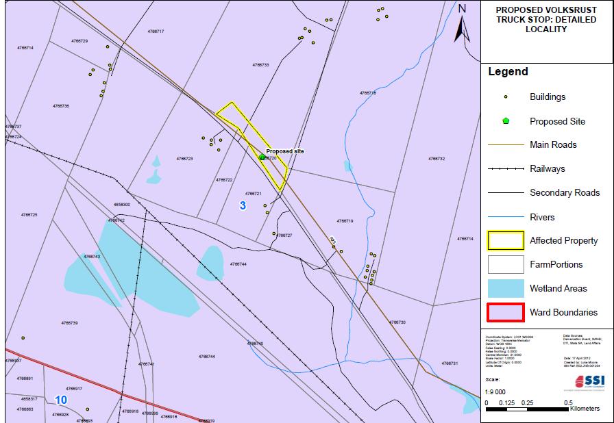
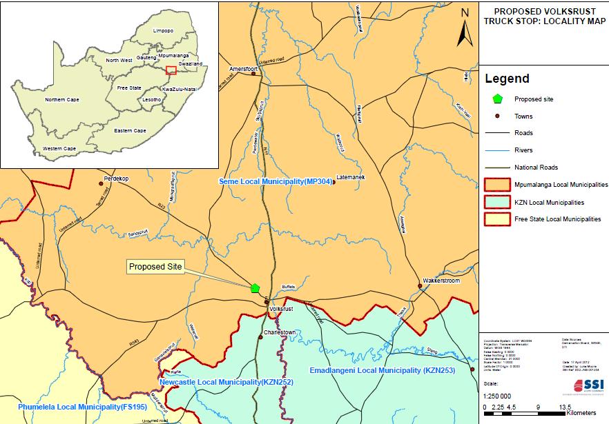
3 CONCLUSION There are no visible cultural heritage resources or graves on the proposed development site. RECOMMENDATIONS There is no objection to the proposed development of the Volksrust Truck Stop from a cultural heritage resources point of view. If any heritage elements such as graves are revealed during the construction phase, then the correct procedures as described in Act 25 of 1999 should be adhered to. SITE INFORMATION Owners contact details: Mr. Kobus Kok P.O. Box 1217 Tel: Volksrust Fax: Cell: // kobus.kok@telkomsa.net // harperattorn@telkomsa.net Developers contact details: Mr. Kobus Kok P.O. Box 1217 Tel: Volksrust Fax: Cell: // kobus.kok@telkomsa.net // harperattorn@telkomsa.net Consultants contact details: Malcolm Roods SSI Engineers and Environmental Consultants PO Box 867 Gallo Manor, 2052 South Africa Tel: +27 (0) Fax: +27 (0) malcolmr@ssi.co.za Type of development (e.g. low cost housing project, mining etc.) Filling Station and Truck Stop Whether rezoning and/or subdivision of land is involved: Rezoning is not required Full location of Province, Magisterial District/Local Authority, property (e.g. farm, erf name and number: The farm is Smalkloof 122, portion 9. 3
4 Location map must have the polygon of the area to be surveyed on it and full geographical coordinates for all relevant points and where applicable indication of the area to be developed (footprint): (Google map is attached and the coordinates taken during site visit) REFERENCES 1/ Map 2729 BD Archaeological database of the National Cultural Museum Pretoria 4
5 5
6 6
2017/03/31. Figure 9. British military graveyard at Fort Cox. Figure 10. Memorial stone. HIA: Fort Cox College Water and Sanitation Services
 2017/03/31 Figure 9. British military graveyard at Fort Cox Figure 10. Memorial stone 22 2017/03/31 Figure 11. Memorial stone Previous Studies An extensive research into the SAHRIS database resulted in
Heritage Survey report for THE KOMATI POWER STATION ASH DAM EXTENSION, MIDDELBURG MAGISTERIAL DISTRICT, MPUMALANGA PROVINCE
 report for THE KOMATI POWER STATION ASH DAM EXTENSION, MIDDELBURG MAGISTERIAL DISTRICT, MPUMALANGA PROVINCE THE PROJECT: Development of a new ash dam for the coal fired power station. THIS REPORT: Heritage
Comprehensive and Professional Solutions for all Heritage Related Matters CK 2006/014630/23 VAT NO.:
 P.O.BOX73703 LYNNWOOD RIDGE 0040 Tel: 083 459 3091 Fax: 086 695 7247 Email: pelseranton@gmail.com Comprehensive and Professional Solutions for all Heritage Related Matters CK 2006/014630/23 VAT NO.: 4360226270
Environmental Scoping Report for the proposed establishment of a New Coal-Fired Power Station in the Lephalale Area, Limpopo Province
 12. ARCHAEOLOGICAL AND HERITAGE RESOURCES The National Cultural History Museum was contracted by Bohlweki Environmental to survey an area in which it is proposed to re-align an existing road and construct
Heritage impact assessment for the PROPOSED MEDUPI POWER STATION CONVEYOR ROUTE, LEPHALALE REGION, LIMPOPO PROVINCE
 Heritage impact assessment for the PROPOSED MEDUPI POWER STATION CONVEYOR ROUTE, LEPHALALE REGION, LIMPOPO PROVINCE HERITAGE IMPACT ASSESSMENT FOR THE PROPOSED MEDUPI POWER STATION CONVEYOR ROUTE, LEPHALALE
Heritage impact survey report for the PROPOSED GREEN HOUSE LODGE, MADIKWE GAME RESERVE, THABAZIMBI MAGISTERIAL DISTRICT, LIMPOPO PROVINCE
 Heritage impact survey report for the PROPOSED GREEN HOUSE LODGE, MADIKWE GAME RESERVE, THABAZIMBI MAGISTERIAL DISTRICT, LIMPOPO PROVINCE THE PROJECT: Development of a lodge facility. THIS REPORT: HERITAGE
This Unit is suitable for candidates with no previous archaeological experience but who have an interest in history and/or archaeology.
 National Unit specification: general information Unit code: H29B 12 Superclass: DC Publication date: August 2012 Source: Scottish Qualifications Authority Version: 01 Summary This Unit introduces candidates
Phase 2 Archaeological Assessment of Late Iron Age Structures on the Farm Ledig 909 JQ (Quality Vacation Club and Golf Course), North West Province
, North West Province") Francois P Coetzee Phase 2: Ledig 909JQ Phase 2 Archaeological Assessment of Late Iron Age Structures on the Farm Ledig 909 JQ (Quality Vacation Club and Golf Course), North West Province For Chand Environmental
Francois P Coetzee Phase 2: Ledig 909JQ Phase 2 Archaeological Assessment of Late Iron Age Structures on the Farm Ledig 909 JQ (Quality Vacation Club and Golf Course), North West Province For Chand Environmental
DESKTOP PALAEONTOLOGICAL IMPACT ASSESSMENT. Bloemhof Extensions 11, 12 and 13 Township development in Lekwa-Teemane Local Municipality
 DESKTOP PALAEONTOLOGICAL IMPACT ASSESSMENT Bloemhof Extensions 11, 12 and 13 Township development in Lekwa-Teemane Local Municipality Specialist report by: Bruce Rubidge Address: PO Box 85346 Emmarentia
Appendix E: Wetland Verification Exercise
 Appendix E: Wetland Verification Exercise Scientific Aquatic Services Applying science to the real world P.O. Box 751779 Gardenview 2047 Tel 011 616 7893 Fax 011 615 6240 www.sasenvironmental.co.za admin@sasenvironmental.co.za
MOOI-MGENI TRANSFER SCHEME, PHASE 2, KWA-ZULU NATAL HERITAGE IMPACT ASSESSMENT
 MOOI-MGENI TRANSFER SCHEME, PHASE 2, KWA-ZULU NATAL HERITAGE IMPACT ASSESSMENT Gavin Anderson Umlando: Archaeological Tourism and Resource Management PO Box 102532, Meerensee, 3901 Phone/fax: 035-7531785
Belmont Development Corporation
 A PHASE 1 ARCHAEOLOGICAL IMPACT ASSESSMENT FOR THE PROPOSED RESIDENTIAL DEVELOPMENT ON THE EXISTING GRAHAMSTOWN GOLF COURSE, GRAHAMSTOWN, MAKANA MUNICIPALITY, CACADU DISTRICT MUNICIPALITY, EASTERN CAPE
HERITAGE TOURISM. B y M. Liga Suryadana
 HERITAGE TOURISM B y M. Liga Suryadana Some definitions of Heritage: the natural, cultural and built environments of an area (Millar, S., 1991, Heritage management for heritage tourism, in Medlik, S.,
Minimum Standards for Heritage Specialist Studies in terms of Section 38 (1) and 38(8) National Heritage Resources Act (No.
 and 38(8) National Heritage Resources Act (No.") Minimum Standards for Heritage Specialist Studies in terms of Section 38 (1) and 38(8) National Heritage Resources Act (No. 25 of 1999) Table of Contents I. General Information... 1 1. What Are Heritage
Minimum Standards for Heritage Specialist Studies in terms of Section 38 (1) and 38(8) National Heritage Resources Act (No. 25 of 1999) Table of Contents I. General Information... 1 1. What Are Heritage
11 PALAEONTOLOGY, ARCHAEOLOGY AND CULTURAL HERITAGE IMPACTS
 11 PALAEONTOLOGY, ARCHAEOLOGY AND CULTURAL HERITAGE IMPACTS This chapter discusses the potential impacts on palaeontology, archaeology and cultural heritage resources resulting from the establishment of
Palaeontological Desktop Study Scheding Chrome Mine, Capricorn District
 Email: bruce.rubidge@wits.ac.za 7 September 2013 Ms Zoe Gebhardt Environmental Consultant Prime Resources PO Box 2316 Parklands 2121 E-Mail: zoe@resources.co.za Dear Ms Gebhardt, Palaeontological Desktop
Initial Borehole Drilling in the Hornepayne and Manitouwadge Area
 MAY 2017 PRELIMINARY ASSESSMENT OF POTENTIAL SUITABILITY Initial Borehole Drilling in the Hornepayne and Manitouwadge Area In 2010, the Nuclear Waste Management Organization (NWMO) began technical and
HERITAGE ASSESSMENT REPORT ZEUS SUBSTATION EXPANSION, VLAKFONTEIN 328, GERT SIBANDE (DC 30) DISTRICT, MPUMALANGA, SOUTH AFRICA
 DISTRICT, MPUMALANGA, SOUTH AFRICA") HERITAGE ASSESSMENT REPORT ZEUS SUBSTATION EXPANSION, VLAKFONTEIN 328, GERT SIBANDE (DC 30) DISTRICT, MPUMALANGA, SOUTH AFRICA REPORT FOR PBA INTERNATIONAL Zoë Henderson & Chriselle Koortzen 19 June 2007
HERITAGE ASSESSMENT REPORT ZEUS SUBSTATION EXPANSION, VLAKFONTEIN 328, GERT SIBANDE (DC 30) DISTRICT, MPUMALANGA, SOUTH AFRICA REPORT FOR PBA INTERNATIONAL Zoë Henderson & Chriselle Koortzen 19 June 2007
INTERNATIONAL CULTURAL TOURISM CHARTER Managing Tourism at Places of Heritage Significance (1999)
") INTERNATIONAL CULTURAL TOURISM CHARTER Managing Tourism at Places of Heritage Significance (1999) Adopted by ICOMOS at the 12th General Assembly in Mexico, October 1999. INTRODUCTION The Charter Ethos
INTERNATIONAL CULTURAL TOURISM CHARTER Managing Tourism at Places of Heritage Significance (1999) Adopted by ICOMOS at the 12th General Assembly in Mexico, October 1999. INTRODUCTION The Charter Ethos
Archaeological Monitoring of Land at Seacrest, Cliff Drive, Warden, Isle of Sheppey, Kent
 Archaeological Monitoring of Land at Seacrest, Cliff Drive, Warden, Isle of Sheppey, Kent Site Code SEA/WB/15 Report for Kevin & Lesley O Brian Date of report 14/10/2015 SWAT ARCHAEOLOGY Swale and Thames
Charlmont Road, Tooting, London Borough of Wandsworth
 123-125 Charlmont Road, Tooting, London Borough of Wandsworth An Archaeological Evaluation For Eramo Developments Limited by Andrew Weale and Andrew Taylor Thames Valley Archaeological Services Ltd Site
Using West Virginia GeoExplorer's Historical Gazetteer Feature
 Using West Virginia GeoExplorer's Historical Gazetteer Feature gaz - et - teer: a geographical index or dictionary This Historical Gazetteer is a geographical database of place names found in historical
Initial Borehole Drilling and Testing in or Near Ignace
 JUNE 2016 PRELIMINARY ASSESSMENT OF POTENTIAL SUITABILITY Initial Borehole Drilling and Testing in or Near Ignace DRAFT FOR DISCUSSION WITH COMMUNITIES In 2010, the Nuclear Waste Management Organization
Tłı chǫ All-season Road Archaeological Site Chance Find Protocol
 Tłı chǫ All-season Road Archaeological Site Chance Find Protocol Insert applicable LWB project numbers Version 1 Revision History REVISION HISTORY Version Date Notes/Revisions 1 Original version of plan
5.2. Historic heritage. Photo: Vaughan Homestead, Long Bay Regional Park, Auckland. (Source: ARC). Historic heritage
. Historic heritage") Photo: Vaughan Homestead, Long Bay Regional Park, Auckland. (Source: ARC). 274 Hazards and heritage Contents 5.2 Introduction 276 monitoring programmes 276 The state of historic heritage 277 Heritage items
Photo: Vaughan Homestead, Long Bay Regional Park, Auckland. (Source: ARC). 274 Hazards and heritage Contents 5.2 Introduction 276 monitoring programmes 276 The state of historic heritage 277 Heritage items
Appendix D: Chance Find Procedures
 Heritage Statement for a Proposed Acetylene Gas Production Facility, located near Witkopdorp, Daleside, south of Johannesburg ERM2556 Appendix D: Chance Find Procedures CHANCE FIND PROCEDURES (CFPS) FOR
Land at Larchwood Farm, Whitehorse Lane Finchampstead, Berkshire
 Land at Larchwood Farm, Whitehorse Lane Finchampstead, Berkshire An Archaeological Evaluation for Mr. John Westbrook by James McNicoll-Norbury Thames Valley Archaeological Services Ltd Site Code LFF08/103
PW Parkway ES Prince William County, Virginia WSSI #
 PW Parkway ES Prince William County, Virginia WSSI #15.3 Cultural Resources Site Assessment November 15 Prepared for: Prince William County Public Schools P.O. Box 39 Manassas, Virginia 1 Prepared by:
Initial Borehole Drilling and Testing in Central Huron,
 JULY 2016 PRELIMINARY ASSESSMENT OF POTENTIAL SUITABILITY Initial Borehole Drilling and Testing in Central Huron, Huron-Kinloss and South Bruce DRAFT FOR DISCUSSION WITH COMMUNITIES In 2012, at the request
25. NON-INDIGENOUS CULTURAL HERITAGE
 25. NON-INDIGENOUS CULTURAL HERITAGE This chapter describes the non-indigenous cultural heritage environment within and surrounding the study area. Non-Indigenous cultural heritage refers to cultural heritage
Why Geography Matters
 Why Geography Matters Vocabulary words geography relative location absolute location physical feature human feature region modify adapt cause effect geography: The study of the Earth s physical and human
Touring Around the Islands of Atlantic Canada
 Lesson Overview Touring Around the Islands of Atlantic Canada In this lesson, students will examine the history and heritage of the islands of Atlantic Canada and examine their similarities and differences.
Geophysical Survey. Ballymount Co. Dublin. Licence Ref. 02R029. By John Nicholls Margaret Gowen & Co. Ltd. For LRT
 Geophysical Survey Ballymount Co. Dublin Licence Ref. 02R029 By John Nicholls Margaret Gowen & Co. Ltd. For LRT 4 th April 2002 Illustrations List of Figures Figure 1 Site Location 1: 50000 Figure 2 Survey
4.3 CULTURAL RESOURCES
 4.3 CULTURAL RESOURCES This section of the EIR analyzes the proposed project s potential impacts on archaeological and paleontological resources. This analysis summarizes the findings of the Archaeological
Exploring the World s Cultures 90 Minute Social Studies Lesson Gallery Program Grades: 3-7. Exploring the World s Cultures. Description.
 TEACHER GUIDE Exploring the World s Cultures 90 Minute Social Studies Lesson Gallery Program Grades: 3-7 Exploring the World s Cultures Description Travel the world and connect with cultures with which
Archaeological Heritage Impact Assessment
 Archaeological Heritage Impact Assessment Remainder Portion 54 of the Farm Hooge Kraal 238, Magisterial District George, Western Cape Province: proposed development of a small, Eco Friendly and environmentally
PHASE 1 ARCHAEOLOGICAL ASSESSMENT OF A PORTION OF MAIN ROAD 174 N1 TO KLIPHEUWEL
 PHASE 1 ARCHAEOLOGICAL ASSESSMENT OF A PORTION OF MAIN ROAD 174 N1 TO KLIPHEUWEL Prepared for Erica Van Den Honert (Environmental Consultant) March 1998 Prepared by Archaeology Contracts Office Department
Least-Cost Transportation Corridor Analysis Using Raster Data.
 Least-Cost Transportation Corridor Analysis Using Raster Data What is GeoMedia Grid: Key Grid Concepts Vector Model Vector based systems show data by means of a series of points, lines, and polygons. Each
Archaeological Assessment of Scroggs Hill Forest
 Archaeological Assessment of Scroggs Hill Forest Prepared for Fulton Hogan Limited by Chris Jacomb and Emma Brooks Southern Pacific Archaeological Research August 2009 CONTENTS Introduction and Background...
I can identify the continents and oceans using globes and maps. I can locate the selected world communities in relation to oceans and continents.
 I can identify the continents and oceans using globes and maps. I can locate the selected world communities in relation to oceans and continents. I can identify the differences between a globe and a map.
SOIL INFORMATION FOR PUMPED WATER STORAGE SCHEME, STEELPOORT VALLEY
 REPORT On contract research for Bohlweki Environmental SOIL INFORMATION FOR PUMPED WATER STORAGE SCHEME, STEELPOORT VALLEY February 2007 By D.G. Paterson ARC-Institute for Soil, Climate and Water, Private
CK107 BA in Geographical and Archaeological Sciences
 CK107 BA in Geographical and Archaeological Sciences CK107 BA in Geographical and Archaeological Science Geography and Archaeology are closely related disciplines, concerned with concepts of time and space
COMMUNITY SERVICE AREA
 INSTITUTE FOR TRIBAL ENVIRONMENTAL PROFESSIONALS Tribal Waste and Response Assistance Program (TWRAP) Developing and Implementing a Tribal Integrated Solid Waste Management Plan April 12-14, 2016 Palm
Measuring the intangible: towards enviro-cultural justice Jessica de Beer * (GIBB, article based on MA Mini-Dissertation, 2018)
") IAIA18 Conference Proceedings Environmental Justice in Societies in Transition 38 th Annual Conference of the International Association for Impact Assessment 16-19 May 2018 Durban Intl. Convention Center
IAIA18 Conference Proceedings Environmental Justice in Societies in Transition 38 th Annual Conference of the International Association for Impact Assessment 16-19 May 2018 Durban Intl. Convention Center
INTRODUCTION 1. Meru County in Kenya
 1 Meru County in Kenya 1.1.0 Introduction: Vernacular buildings are human constructs that result from interrelations between ecological, economic, material, political and social factors. Given that the
Revised February 15, 2017
 Revised February 15, 2017 I-C-1 I-A-1* I-D-1* II-E-2* Describe and compare the characteristics of Describe the relationships among ancient Organize information by sequencing, Describe, locate, and compare
A303 Stonehenge Amesbury to Berwick Down Archaeological Geophysical Survey Design Brief
 A303 Stonehenge Amesbury to Berwick Down Archaeological Geophysical Survey Design Brief March 2016 Table of contents Chapter Pages 1 Summary 1 2 Background 1 2.1 Purpose 1 2.2 Location 2 2.3 Archaeological
ADDITIONAL PHASE IA ARCHAEOLOGICAL SURVEY FOR THE UMORE PARK SAND AND GRAVEL MINING ENVIRONMENTAL REVIEW SERVICES, DAKOTA COUNTY, MINNESOTA
 ADDITIONAL PHASE IA ARCHAEOLOGICAL SURVEY FOR THE UMORE PARK SAND AND GRAVEL MINING ENVIRONMENTAL REVIEW SERVICES, DAKOTA COUNTY, MINNESOTA ADDENDUM I Submitted to: Short Elliot Hendrickson, Inc. Submitted
Town of Taos Request for Proposal Historic Preservation GIS Geodatabase Project April 2007
 Town of Taos Request for Proposal Historic Preservation GIS Geodatabase Project April 2007 1. Background The Town of Taos is requesting proposals from qualified firms or a team of firms who can develop
Chapter 9. Archaeology Resources. Accessing Resources. Chapter 9: Archaeology Resources
 139 Chapter 9 Archaeology Resources Archaeology is the study of human cultures through the physical remains. Archaeology is a field within anthropology. Archaeological materials are physical evidence of
The following maps must be provided as a part of the ADA. The appropriate scale for each map should be determined at the pre application conference.
 Main Street @ Coconut Creek DRI QUESTION 9 MAPS The following maps must be provided as a part of the ADA. The appropriate scale for each map should be determined at the pre application conference. Map
5 th DRAFT OF THE ICOMOS CHARTER ON CULTURAL ROUTES (September, 2005)
") 1 5 th DRAFT OF THE ICOMOS CHARTER ON CULTURAL ROUTES (September, 2005) Working document presented for discussion at the 15 th GA in China in view of further comments and eventual adoption at the 16 th
1 5 th DRAFT OF THE ICOMOS CHARTER ON CULTURAL ROUTES (September, 2005) Working document presented for discussion at the 15 th GA in China in view of further comments and eventual adoption at the 16 th
ANALYSIS OF URBAN PLANNING IN ISA TOWN USING GEOGRAPHIC INFORMATION SYSTEMS TECHNIQUES
 ANALYSIS OF URBAN PLANNING IN ISA TOWN USING GEOGRAPHIC INFORMATION SYSTEMS TECHNIQUES Lamya HAIDER, Prof. Mohamed AIT BELAID (*) Corre, and Dr. Anwar S. Khalil Arabian Gulf University (AGU), College of
Why Do We Live Here? : A Historical Geographical Study of La Tabatiere, Quebec North Shore
 Why Do We Live Here? : A Historical Geographical Study of La Tabatiere, Quebec North Shore Lesson Overview Many communities and their occupants have historical connections to exploration routes and traditional
Jordan's Strategic Research Agenda in cultural heritage
 Jordan's Strategic Research Agenda in cultural heritage Analysis of main results Alessandra Gandini Amman, Jordan 3 rd November 2013 Main objectives The work performed had the main objective of giving
Monitoring Program Terms of Reference HERITAGE AND CULTURE INFORMATION PLAN
 Monitoring Program Terms of Reference HERITAGE AND CULTURE INFORMATION PLAN GMSMON-21a Peace - Archaeological Overview Assessment May 2, 2008 1.0 OVERVIEW HERITAGE AND CULTURE INFORMATION PLAN TERMS OF
Archaetnos Culture & Cultural Resource Consultants BK /23
 Archaetnos Culture & Cultural Resource Consultants BK 98 09854/23 A HERITAGE IMPACT ASSESSMENT REPORT FOR THE PROPOSED SYLVANIA RESOURCES VOLSPRUIT MINE ON THE FARMS VOLSPRUIT 326 KR and ZOETVELD 294 KR,
Harry Walter Jassby, from Montreal, Canada, was one of ten children part of a large Jewish family.
 Remembered in an English Churchyard Harry Walter Jassby, from Montreal, Canada, was one of ten children part of a large Jewish family. Mr and Mrs M Jassby resided at 4143 Oxford Avenue, Montreal and with
GIS AND REMOTE SENSING FOR OPEN SPACE PROTECTION ENVIRONMENTAL MANAGEMENT DEPARTMENT
 GIS AND REMOTE SENSING FOR OPEN SPACE PROTECTION ENVIRONMENTAL MANAGEMENT DEPARTMENT 22 nd May 2009 1 Introduction It is said that more than 80% of the City s activities throughout the world are spatially
Al Ain Cultural Heritage Management Strategy 1/102
 AL AIN CULTURAL HERITAGE MANAGEMENT STRATEGY EXECUTIVE SUMMARY The cultural heritage of Al Ain is rich and varied; it consists of tangible and intangible resources and incorporates archaeological sites,
LIFE Science 3. Flow of Matter & Energy GLE Describe how animals use food to obtain energy and materials for growth and repair
 Third Grade Animals All Around (07/09/09) Vocabulary: amphibians, attributes, birds, extinct, feathers, gills, habitats, life cycle, living, lungs, mammals, manmade, non-living, offspring, organism, patterns,
Diddenham Court, Grazeley, Reading, Berkshire, Phase 2
 Diddenham Court, Grazeley, Reading, Berkshire, Phase 2 An Archaeological Watching Brief For Fenchurch Estates (Diddenham) Ltd by Steve Hammond and Simon Cass Thames Valley Archaeological Services Ltd Site
Bipole III Transmission Project Construction Environmental Protection Plan Construction Section N2 Environmentally Sensitive Site Locations Map 81
 ± DOCUMENT PATH: G :\_GIS_PROJECT_FOLDER\00_HYDRO\111440054_BPIII_EPP\ARCMAP\ESS_N2\BPIII_CENVPP_N1N2N3N4C1SECTIONBASEMAP_MAPBOOK_BTB_STANTEC_20131201.MXD 196 Coordinate System: UTM Zone NAD83 Data Source:
correlated to the NEW MEXICO Content Standards and Benchmarks for Ancient History (ANHI) grade 6
 grade 6") correlated to the NEW MEXICO Content Standards and Benchmarks for Ancient History (ANHI) grade 6 Introduction to McDougal Littell World Cultures and Geography: Eastern Hemisphere World Cultures and Geography:
correlated to the NEW MEXICO Content Standards and Benchmarks for Ancient History (ANHI) grade 6 Introduction to McDougal Littell World Cultures and Geography: Eastern Hemisphere World Cultures and Geography:
LOUISIANA STUDENT STANDARDS FOR SOCIAL STUDIES THAT CORRELATE WITH A FIELD TRIP TO DESTREHAN PLANTATION KINDERGARTEN
 LOUISIANA STUDENT STANDARDS FOR SOCIAL STUDIES THAT CORRELATE WITH A FIELD TRIP TO DESTREHAN PLANTATION KINDERGARTEN Standard 2 Historical Thinking Skills Students distinguish between events, people, and
patersongroup Mineral Aggregate Assessment 3119 Carp Road Ottawa, Ontario Prepared For Mr. Greg LeBlanc March 7, 2014 Report: PH2223-REP.
 Geotechnical Engineering Environmental Engineering group Hydrogeology Geological Engineering Archaeological Studies Materials Testing 3119 Carp Road Prepared For Mr. Greg LeBlanc March 7, 2014 Paterson
CLT/HER/CHP/OG 1- page 29
 CLT/HER/CHP/OG 1- page 29 MODEL INVENTORY SHEET FOR UNDERWATER CULTURAL HERITAGE COUNTRY REGION, PROVINCE COMPETENT AUTHORITY REGISTERED BY (name, position) Date Email / Tel nº SITE NAME (provide also
Tourism. April State Planning Policy state interest guideline. Department of Infrastructure, Local Government and Planning
 Department of Infrastructure, Local Government and Planning State Planning Policy state interest guideline Tourism April 2016 Great state. Great opportunity. Preface Using this state interest guideline
Great Native American Nations
 Great Native American Nations Episode 1 Episode 2 Episode 3 Episode 4 Episode 5 Episode 6 Cheyenne: Indians of the Plains Iroquois: Indians of the Northeast Lakota Sioux: Indians of the Plains Navajo:
I. M. Schoeman North West University, South Africa. Abstract
 Urban Transport XX 607 Land use and transportation integration within the greater area of the North West University (Potchefstroom Campus), South Africa: problems, prospects and solutions I. M. Schoeman
COLORADO CULTURAL RESOURCE SURVEY Management Data Form Rev. 11/10
 COLORADO CULTURAL RESOURCE SURVEY OAHP1400 Rev. 11/10 A should be completed for each cultural resource recorded during an archaeological survey. Isolated finds and revisits are the exception and they do
Cultural heritage impact assessment for THE CONSTRUCTION OF THE PROPOSED SHANGONI GATE AND ASSOCIATED INFRASTRUCTURE IN THE KRUGER NATIONAL PARK,
 Cultural heritage impact assessment for THE CONSTRUCTION OF THE PROPOSED SHANGONI GATE AND ASSOCIATED INFRASTRUCTURE IN THE KRUGER NATIONAL PARK, LIMPOPO PROVINCE CULTURAL HERITAGE ASSESSMENT FOR THE CONSTRUCTION
North Carolina Essential Standards Kindergarten Social Studies
 North Carolina s Kindergarten Social Studies Kindergarten through second grade students are introduced to an integrative approach of Social Studies by exploring aspects of self, others, families and communities
Guidance for implementing the Potential Fossil Yield Classification (PFYC) System
 System") Guidance for implementing the Potential Fossil Yield Classification (PFYC) System Introduction The PFYC system will aid in assessing the potential to discover or impact significant paleontological resources.
Guidance for implementing the Potential Fossil Yield Classification (PFYC) System Introduction The PFYC system will aid in assessing the potential to discover or impact significant paleontological resources.
WS/FCS Unit Planning Organizer
 WS/FCS Unit Planning Organizer Subject(s) Social Studies Conceptual Lenses Grade/Course 3rd Place Unit of Study Five Themes of Geography Location Unit Title Pacing Geo Explorers 20-22 days Human environment
Warwickshire Geological Conservation Group
 Warwickshire Geological Conservation Group Warwickshire Local Geological Site Site No: 23 Kings Hill Farm, Finham Geological Formations Glacial erratic Criteria Form p2 Description p3 Photographs p4 Location
Geography (GEOG) Introduction to Geography Global Change and Natural Disasters and Environmental Change
 Introduction to Geography Global Change and Natural Disasters and Environmental Change") Geography (GEOG) Head of Department: Professor Jeffrey P. Osleeb Department Office: Room 422, Philip E. Austin Building For major requirements, see the College of Liberal Arts and Sciences section of this
Geography (GEOG) Head of Department: Professor Jeffrey P. Osleeb Department Office: Room 422, Philip E. Austin Building For major requirements, see the College of Liberal Arts and Sciences section of this
Generic Success Criteria
 Generic Success Criteria Significance I can identify a short term and long term impact that a development/event/issue has/had locally/globally. I can discuss (verbally, graphically, etc.) how a development/event/issue
WAPICHAN TERRITORIAL GOVERNANCE MODEL. South Central and South Rupununi Districts Toshaos Councils, Region 9, GUYANA
 WAPICHAN TERRITORIAL GOVERNANCE MODEL South Central and South Rupununi Districts Toshaos Councils, Region 9, GUYANA Chief Kokoi, COP13 Cancún, 11 December 2016 CONTENTS OF OUR TERRITORIAL GOVERNANCE PLAN:
Mapping the Urban Farming in Chinese Cities:
 Submission to EDC Student of the Year Award 2015 A old female is cultivating the a public green space in the residential community(xiaoqu in Chinese characters) Source:baidu.com 2015. Mapping the Urban
North Carolina Standard Course of Study Science Grade: 6 - Adopted: Earth: Systems, Structures and Processes
 Main Criteria: North Carolina Standard Course of Study Secondary Criteria: Subjects: Science, Social Studies Grade: 6 Correlation Options: Show Correlated North Carolina Standard Course of Study Science
DRAFT
 A84536-22, A81184-3 Discovery of Human Remains On Site Lead Licensing and Environmental Assessment Archaeologist Manitoba Historic Resources Branch (HRB) RCMP STOP activities at location Step 6
REQUEST FOR PROPOSALS
 GRANDE CACHE REGIONAL DINOSAUR TRACKS FOUNDATION REQUEST FOR PROPOSALS Grande Cache Regional Dinosaur Tracks Feasibility Study Box 300 Grande Cache, AB. T0E 0Y0 INTRODUCTION AND SUMMARY The ( Foundation
Social Studies Grade 2 - Building a Society
 Social Studies Grade 2 - Building a Society Description The second grade curriculum provides students with a broad view of the political units around them, specifically their town, state, and country.
Considerations of Urban Design and Microclimate in Historical Buildings Environment under Climate Change
 Considerations of Urban Design and Microclimate in Historical Buildings Environment under Climate Change Research team: Dr. Esther H.K. Yung, Mr. Z.N. Tan, Dr. C.K. Chau, Prof. Edwin, H.W. Chan Department
Social Values for Ecosystem Services (SolVES)
") Social Values for Ecosystem Services (SolVES) Presented to the Chesapeake Bay Program Scientific, Technical Assessment and Reporting (STAR) Team Meeting Annapolis, Maryland November 5, 2012 US Department
Social Values for Ecosystem Services (SolVES) Presented to the Chesapeake Bay Program Scientific, Technical Assessment and Reporting (STAR) Team Meeting Annapolis, Maryland November 5, 2012 US Department
HERITAGE SCREENER. CTS Reference Number: CTS18_244. HWC Ref: Date: 25 January 2019
 CTS Reference Number: CTS18_244 HERITAGE SCREENER HWC Ref: 19012510 Client: EnviroAfrica Date: 25 January 2019 Title: The proposed upgrade of the Klaarstroom Oxidation Pond Wastewater Treatment System,
Private Protected Areas Towards a comprehensive map for South Africa Alta De Vos* & Graeme Cumming
 Private Protected Areas Towards a comprehensive map for South Africa Alta De Vos* & Graeme Cumming alta.devos@gmail.com 2013 Biodiversity Planning Forum Golden Gate Highlands National Park May 2013 Spatial
The use of Geographic Information Systems (GIS) in Electrification
 in Electrification") The use of Geographic Information Systems (GIS) in Electrification S lindi Mhlongo, GIS Advisor, Eskom, South Africa About this Presentation Introduction About Eskom Who is GIS What is GIS GIS in Electrification
The use of Geographic Information Systems (GIS) in Electrification S lindi Mhlongo, GIS Advisor, Eskom, South Africa About this Presentation Introduction About Eskom Who is GIS What is GIS GIS in Electrification
ACTON COMMUNITY WIDE ARCHAEOLOGICAL RECONNAISSANCE SURVEY. Town of Acton and PAL, Inc.
 ACTON COMMUNITY WIDE ARCHAEOLOGICAL RECONNAISSANCE SURVEY Town of Acton and PAL, Inc. Objectives and Scope of Work Four phase study; (1. research, 2. draft report outline, resource protection bylaw, 3.
GEOSPATIAL ONLINE WEB-TOOLS CapeFarmMapper & CAMIS
 GEOSPATIAL ONLINE WEB-TOOLS CapeFarmMapper & CAMIS F.C. Basson 14 March 2017 Overview Spatial information and technology has become more important and relevant Applications Mapping of Agricultural footprint
Efficiencies in Data Acquisition and Transformation
 Efficiencies in Data Acquisition and Transformation Andrew LEYZACK Canada Key words: Hydrography, IHO S-57, Nautical Chart SUMMARY For many hydrographic offices, the introduction of electronic nautical
Acrefield Cottage, Winkfield Street, Maidens Green, Winkfield, Windsor, Berkshire
 Acrefield Cottage, Winkfield Street, Maidens Green, Winkfield, Windsor, Berkshire An Archaeological Watching Brief For Mr and Mrs Elia by Pamela Jenkins Thames Valley Archaeological Services Ltd Site Code
Current Functions (Enter categories from instructions) Materials (Enter categories from instructions)
 Materials (Enter categories from instructions)") Site Inventory Form State Inventory No. 92-00490 New Supplemental State Historical Society of Iowa Part of a district with known boundaries (enter inventory no.) 92-00349 (November 2005) Relationship:
Site Inventory Form State Inventory No. 92-00490 New Supplemental State Historical Society of Iowa Part of a district with known boundaries (enter inventory no.) 92-00349 (November 2005) Relationship:
Rising from the Depths Utilising Marine Cultural Heritage in East Africa to help develop sustainable social, economic and cultural benefits
 KENYA MEETING, 23 rd FEBRUARY 2018 1 Rising from the Depths Utilising Marine Cultural Heritage in East Africa to help develop sustainable social, economic and cultural benefits 1. Introduction The Rising
Community Engagement in Cultural Routes SiTI Higher Institute on Territorial Systems for Innovation Sara Levi Sacerdotti
 Transnational Workshop Wroclaw, 7th-8th December 2016 Community Engagement in Cultural Routes SiTI Higher Institute on Territorial Systems for Innovation Sara Levi Sacerdotti levi@siti.polito.it TAKING
Additional Testing for Padre Dam Eastern Service Area Secondary Connection- Alternative Site Location, San Diego County, California
 Mark Niemiec Padre Dam Municipal Water District P.O. Box 719003 9300 Fanita Parkway Santee, California 92072 Re: Additional Testing for Padre Dam Eastern Service Area Secondary Connection- Alternative
Programs Aligned With: Kindergarten Social Studies
 Programs Aligned With: Kindergarten Social Studies Progressive Waste Solutions K.2.1 Compare and contrast children and families today with those in the past using various sources K.3.2 Identify maps and
Social Studies Standard Articulated by Grade Level
 History Strands introduce the concept of exploration as a means of discovery and a way of exchanging ideas, goods, and culture. Important presidents and symbols of our country are also introduced. Strand
City of Lockport Historic Resources Survey - Section METHODOLOGY
 2.0 METHODOLOGY Clinton Brown Company PN 07-008 2-1 April 2011 2.0 METHODOLOGY This methodology statement is prepared as part of the project tasks. It outlines the research sources identified, field strategies,