SHORELINE MANAGEMENT PLAN FOR OWEN ANCHORAGE AND COCKBURN SOUND SHORELINE MONITORING PLAN
|
|
|
- Wendy Gilmore
- 5 years ago
- Views:
Transcription


1 SHORELINE MANAGEMENT PLAN FOR OWEN ANCHORAGE AND COCKBURN SOUND SHORELINE MONITORING PLAN CHAPTER EIGHT OF DOCUMENT: LONG-TERM SHELLSAND DREDGING, OWEN ANCHORAGE ENVIRONMENTAL MANAGEMENT PROGRAMME JUNE 2003
2 p:\cockburn\projmgt\ermp\env management plans\chapter 8.doc 24/06/2003; 1:56 PM CHAPTER EIGHT OF DOCUMENT: LONG-TERM SHELLSAND DREDGING OWEN ANCHORAGE ENVIRONMENTAL MANAGEMENT PROGRAMME SHORELINE MANAGEMENT PLAN FOR OWEN ANCHORAGE AND COCKBURN SOUND SHORELINE MONITORING PLAN Prepared for: COCKBURN CEMENT LIMITED Prepared by: DAL SCIENCE & ENGINEERING PTY LTD M.P. ROGERS AND ASSOCIATES PTY LTD ISBN JUNE 2003 REPORT NO. 032/14
3 CONTENTS 1. INTRODUCTION THIS DOCUMENT: SHORELINE MONITORING PLAN FOR OWEN ANCHORAGE AND COCKBURN SOUND LONG-TERM SHELLSAND DREDGING, OWEN ANCHORAGE MINISTERIAL CONDITIONS: LONG-TERM SHELLSAND DREDGING, OWEN ANCHORAGE 1 2. SHORELINE MONITORING BEACH AND NEARSHORE SURVEYS OWEN ANCHORAGE BEACH & NEARSHORE MONITORING SURVEYS COCKBURN SOUND AERIAL PHOTOGRAPHY & PHOTOGRAMMETRY 5 3. ANALYSIS OF DATA & REPORTING ANALYSIS OF DATA REPORTING Data reports Synthesis reports 6 4. SUMMARY SHORELINE MONITORING PLAN 8 CHAPTER 8: SHORELINE MONITORING PLAN i
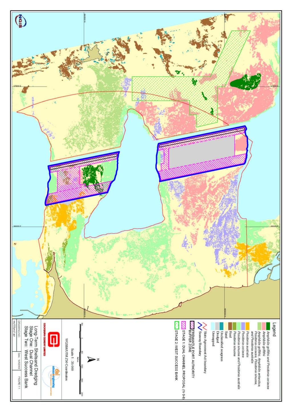
4 TABLES Table 1.1 Commitment by proponent to implement a Shoreline Monitoring Plan for Cockburn Sound and Owen Anchorage 1 Table 4.1 Summary of the shoreline monitoring plan 8 FIGURES Figure 1.1 Long-Term Shellsand Dredging Programme 2 Figure 2.1 Location of Beach Survey Transects, shown as transect lines 1 to 17 4 Figure 3.1 Estimated annual sediment fluxes (m 3 ) in the Owen Anchorage area, CHAPTER 8: SHORELINE MONITORING PLAN ii
5 1. INTRODUCTION 1.1 THIS DOCUMENT: SHORELINE MONITORING PLAN FOR OWEN ANCHORAGE AND COCKBURN SOUND Cockburn Cement Limited (Cockburn) submits this Shoreline Monitoring Plan (SMP) for Owen Anchorage and Cockburn Sound in accordance with the Statement from the Minister for the Environment and Heritage (Statement ) that was issued on 8 July 2002, and which provided approval for the Long-Term Shellsand Dredging, Owen Anchorage. 1.2 LONG-TERM SHELLSAND DREDGING, OWEN ANCHORAGE Cockburn Cement Limited (Cockburn) dredges shellsand from Success Bank and Parmelia Banks, Owen Anchorage, Australia. Shellsand is primarily calcium carbonate used in the production of lime and cement. Cockburn s Long-Term Shellsand Proposal, which was approved on 8 July 2002, (Ministerial Statement 599) consists of two stages shown in Figure 1.1. Stage One involves the completion of two 350 m wide shipping channels through Success and Parmelia Banks, as well as the removal of some high grade shellsand from between the channels both on Success Bank and Parmelia Bank. Stage One dredging will involve the loss of 53 ha of seagrass, of which 40 ha is in the alignment of the two shipping channels, and 13 is from areas to be dredged from between the two shipping channels. Stage One will be completed in eight years (i.e. by mid 2010) after which dredging will be relocated to the Stage Two area which is free of seagrass. 1.3 MINISTERIAL CONDITIONS: LONG-TERM SHELLSAND DREDGING, OWEN ANCHORAGE A series of Ministerial Conditions have been imposed on Cockburn as part of the approval for its Long-Term dredging proposals. Included in these is Condition 2.1 that states that, The proponent shall implement the environmental management commitments documented in schedules 2 and 3 of this statement. Schedule 2 contains a commitment by Cockburn, to implement a Shoreline Monitoring Plan for Cockburn Sound and Owen Anchorage. The details of this commitment are shown in Table 1.1 below. Table 1.1 Commitment by proponent to implement a Shoreline Monitoring Plan for Cockburn Sound and Owen Anchorage 599:P3 Shoreline Monitoring Plan - Preparation Action Prepare a Shoreline Monitoring Plan for Owen Anchorage and Cockburn Sound How Address: 1) monitoring of shoreline position (aerial photography, shoreline surveys); 2) calculation of changes in shoreline position; 3) determination of rates of sediment transport along the shorelines of Owen Anchorage and Cockburn Sound; and 4) identification of sites of erosion/accretion and rates Objective To ensure that dredging does not adversely modify the natural processes that affect the shoreline Evidence Shoreline Monitoring Plan Operations Within 3 months of the following formal authority issued to DMA's under S45 (7) of the EP Act, that is, by 8/10/02 To meet this commitment, Cockburn has prepared this SRP for Owen Anchorage and Cockburn Sound. EPA DPI CHAPTER 8: SHORELINE MONITORING PLAN 1
6
7 2. SHORELINE MONITORING 2.1 BEACH AND NEARSHORE SURVEYS OWEN ANCHORAGE Beach profiles have been surveyed by Cockburn at 15 transects spread along the coast between Woodman Point and Catherine Point since The surveys extend from a fixed benchmark in the dunes to the water line and have been taken each summer and winter. In 1999 the survey program was extended to include an extra two transects north of Catherine Point. The surveys were also augmented with biennial nearshore surveys extending about 250 metres into Owen Anchorage at the location of each of the 17 transects (see Figure 2.1). This set of historical survey data provides excellent baseline information for the Long-Term dredging SMP. It is proposed that this survey sequence for Owen Anchorage be continued as part of the SMP, such that each summer and winter beach surveys continue to be taken along the 17 transects shown on Figure 2.1. The survey of each transect will record the local distance, natural surface level reduced to the Australian Height Datum, the location of the coastal vegetation line, and indicators of the active shore position such as the seaward extent of ephemeral vegetation (accreting sandy coast) and toe of the erosion scarp (eroding sandy coast), as per the Draft Coastal Statement of Planning Policy (Statement of Planning Policy No. 2.6). This will provide an accurate and valuable record of the movement of the position of the coast (mean sea level and coastal vegetation) from one survey to another. The surveys will also help identify the upper limit of the active coastal processes. Every 2 years, the beach surveys will be augmented by extending the transects about 250 metres into Owen Anchorage. Each survey will record the horizontal distance and bearing from a reference point and the natural surface level reduced to the Australian Height Datum, along the transect line. This will provide an accurate and valuable record of the fluctuations in the sub-aqueous profile and also contribute to the determination of the lower limit of the active height of coastal processes. The active height of the coastal processes is important in calculations of volumetric changes of various beach sectors, which are used to determine the amounts and rates of accretion or erosion along the coast. 2.2 BEACH & NEARSHORE MONITORING SURVEYS COCKBURN SOUND It has been estimated that the Long-Term dredging may influence the wave climate and coastal processes of Cockburn Sound. The likelihood of this occurring is extremely low, while further, any influence from dredging will be seen closer to the completion of the dredging programme rather than the beginning. A number of organisations have and are undertaking surveys of shoreline position in Cockburn Sound. These include: Jervoise Bay West Beach Department of Industry & Technology; Challenger Beach Jervoise Bay Project Office; Profiles of various sites eastern shore of Cockburn Sound and Western shore of Garden Island Royal Australian Navy; and Eastern shore of Cockburn Sound Department for Planning and Infrastructure. CHAPTER 8: SHORELINE MONITORING PLAN 3

8 Figure 2.1 Location of Beach Survey Transects, shown as transect lines 1 to 17 CHAPTER 8: SHORELINE MONITORING PLAN 4
9 It is proposed to negotiate with the various bodies who have the information from these monitoring surveys and use them in conjunction with aerial photography to monitor the position of the shoreline of Cockburn Sound. Should additional transect sites be required in the future these can be incorporated into the programme. 2.3 AERIAL PHOTOGRAPHY & PHOTOGRAMMETRY It is proposed to collect and review aerial photography of the coastline of Owen Anchorage and Cockburn Sound each year including that especially flown for Cockburn Cement for the delineation of marine habitats of Owen Anchorage. Cockburn has committed to having aerial photographs flown every summer for this purpose, and the spatially rectified imagery will also be used for the purposes of shoreline monitoring. The review by an experienced Coastal Engineer will provide a broad interpretation of areas of shoreline accretion and erosion, and identify any major sediment transport pathways. Aerial photographs flown each summer at a scale of about 1:15,000 are also commercially available from the Department for Land Administration (DOLA). The photographs will be used where needed for the desktop review and every 3 years controlled photogrammetry will be used to plot the position of the coastal vegetation. The Department for Planning & Infrastructure (DPI) has historical coverage of the shoreline movements in Owen Anchorage and Cockburn Sound. The same plan layout and scale of 1:5,000 will be used for the photogrammetry completed for Cockburn Sound. The accuracy of the photogrammetry will provide positions generally within ±2 metres in the horizontal plane. Under some circumstances the coastal vegetation is difficult to distinguish even in the enlarged photographs. The photogrammetry plots of the position of the coastal vegetation line will provide a measure of gross movements of the shoreline between photograph dates. This coupled with the estimate of the active height of coastal processes will enable quantification of the amount and rate of accretion and erosion in the various coastal sectors. CHAPTER 8: SHORELINE MONITORING PLAN 5
10 3. ANALYSIS OF DATA & REPORTING 3.1 ANALYSIS OF DATA Each year the data will be reviewed by an experienced Coastal Engineer to provide assurance of its quality and also to ensure all of the coastline has been covered. Every third year, the data will be carefully analysed by experienced Coastal Engineers to determine the following: Changes in the position of shoreline using the coastal vegetation line as the appropriate marker; Identification of areas of accretion and erosion along the shorelines of Owen Anchorage and Cockburn Sound; and Quantification of the amount and rate of accretion and erosion along the shorelines of Owen Anchorage and Cockburn Sound. The results of these analyses will be presented on a series of plots and in tabular form. An indicative sediment budget for the Owen Anchorage and Cockburn Sound areas will be prepared using the results from the monitoring. This will be presented in a similar format to that shown in Figure 3.1 which identifies average annual sediment transport rates (sediment fluxes) for the shores of Owen Anchorage covering the period from 1976 to REPORTING Data reports Each year a data report will be prepared and will form part of the Compliance Report issued by Cockburn to the DEP Synthesis reports Every third year as well as after five years, the data will be analysed in detail and a synthesis report will be prepared and submitted to the EPA in order to satisfy Cockburn s commitment. This analysis and synthesis report will address the following: Present the results of the monitoring of the position of the shoreline of Owen Anchorage and Cockburn Sound using beach surveys and aerial photography; Provide calculations of the measured changes in the shoreline position; Determine rates of sediment transport along the shorelines of Owen Anchorage and Cockburn Sound; Identify sites and rates of erosion / accretion; and Determine any link between changes of the shoreline position and Cockburn s long-term dredging. CHAPTER 8: SHORELINE MONITORING PLAN 6
 in the Owen Anchorage")
11 Figure 3.1 Estimated annual sediment fluxes (m 3 ) in the Owen Anchorage area, CHAPTER 8: SHORELINE MONITORING PLAN 7
12 4. SUMMARY SHORELINE MONITORING PLAN The Shoreline Monitoring Plan has been summarised in Table 4.1 below. This provides a list of the various actions as well as the year in which the action will occur. Table 4.1 Summary of the shoreline monitoring plan Shoreline Monitoring Plan Action Year Summer beach survey 2. Summer nearshore survey 3. Winter beach survey 4. Winter nearshore survey 5. Review aerial photographs 6. Photogrammetry 7. Data reports 8. Synthesis reports CHAPTER 8: SHORELINE MONITORING PLAN 8
8.1 Attachment 1: Ambient Weather Conditions at Jervoise Bay, Cockburn Sound
 8.1 Attachment 1: Ambient Weather Conditions at Jervoise Bay, Cockburn Sound Cockburn Sound is 20km south of the Perth-Fremantle area and has two features that are unique along Perth s metropolitan coast
Northern Sea Wall, Kent
 Northern Sea Wall, Kent The North Kent Shoreline Management Plan (SMP) defines management units along the North Kent coast ranging from Management Unit 4a - 1A at the Isle of Grain, to Management Unit
The U.S. Army Corps of Engineers Philadelphia District
 The U.S. Army Corps of Engineers Philadelphia District The Atlantic Coast of New Jersey Regional Sediment Budget 1986-2003 Cape May Point to Manasquan Inlet Final Report March 2006 The Atlantic Coast of
GIS compilation of coastline variability spanning 60 years in the Mackenzie Delta and Tuktoyaktuk in the Beaufort Sea
 GEOLOGICAL SURVEY OF CANADA OPEN FILE 7685 GIS compilation of coastline variability spanning 60 years in the Mackenzie Delta and Tuktoyaktuk in the Beaufort Sea S. Hynes, S.M. Solomon, and D. Whalen 2014
Seaton to Seaton Hole SUMMARY OF PREFERRED PLAN RECOMMENDATIONS AND JUSTIFICATION
 Location reference: Policy Unit reference: Plan: Seaton to Seaton Hole 6a29 and 6a30 SUMMARY OF PREFERRED PLAN RECOMMENDATIONS AND JUSTIFICATION The large number of properties and assets at risk in the
Shoreline Evolution: Lancaster County, Virginia Rappahannock River and Chesapeake Bay Shorelines
 Shoreline Evolution: Lancaster County, Virginia Rappahannock River and Chesapeake Bay Shorelines Virginia Institute of Marine Science College of William & Mary Gloucester Point, Virginia March 2012 Shoreline
Shoreline Evolution: Richmond County, Virginia Rappahannock River Shorelines
 Shoreline Evolution: Richmond County, Virginia Rappahannock River Shorelines Virginia Institute of Marine Science College of William & Mary Gloucester Point, Virginia September 2011 Shoreline Evolution:
Shoreline Evolution: Prince William County, Virginia Potomac River, Occoquan Bay, and Occoquan River Shorelines
 Shoreline Evolution: Prince William County, Virginia Potomac River, Occoquan Bay, and Occoquan River Shorelines Virginia Institute of Marine Science College of William & Mary Gloucester Point, Virginia
PHOTOGRAMMETRY AND GIS TECHNOL 1 OGIES FOR MONITORING COASTAL EROSION ALONG DAR ES SALAAM COASTLINE. By: Z.Y Masele, S.D Mayunga1.
 PHOTOGRAMMETRY AND GIS TECHNOL 1 OGIES FOR MONITORING COASTAL EROSION ALONG DAR ES SALAAM COASTLINE. By: Z.Y Masele, S.D Mayunga1 Abstract Dar Es salaam coastline is seriously suffering from coastal soil
Quantifying Coastal Evolution using Remote Sensing Approaches
 Quantifying Coastal Evolution using Remote Sensing Approaches Sojan Mathew, Linh Truong Hong, Xavier Pellicer*, Colman Gallagher University College Dublin Geological Survey of Ireland* INFOMAR SEMINAR,
SHORELINE AND BEACH PROCESSES: PART 2. Implications for Coastal Engineering
 SHORELINE AND BEACH PROCESSES: PART 2 Implications for Coastal Engineering Objectives of the lecture: Part 2 Show examples of coastal engineering Discuss the practical difficulties of ocean engineering
Cross Boundary Issues
 6 Cross Boundary Issues 6 C R O S S B O U N D A R Y I S S U E S 6.1 Introduction The effects of an activity within the coastal marine area are often felt in adjacent areas, outside of the immediate vicinity
Primer on Coastal Erosion And Habitat Creation
 2 nd Regional Conference Dredging, Beach Nourishment & Bird Conservation Primer on Coastal Erosion And Habitat Creation Timothy Kana Ph.D Source: Newsday 1962 Photo by Kelsey Aerials 1978 Source: U Mass
TECHNIQUES FOR ASSESSING COASTAL HAZARD AREAS FOR THE GISBORNE DISTRICT COAST
 TECHNIQUES FOR ASSESSING COASTAL HAZARD AREAS FOR THE GISBORNE DISTRICT COAST July 1994 C.R. 1994/12 Jeremy G Gibb 2009 All rights reserved. This work is entitled to the full protection given by the Copyright
Erosion Information Paper - Barrow, Alaska Current as of September 14, 2007
 U.S. Army Corps of Engineers ALASKA BASELINE EROSION ASSESSMENT Erosion Information Paper - Barrow, Alaska Current as of September 14, 2007 Community Information Barrow (BARE-row, a.k.a. Ukpeagvik), population
Connecticut Coastal Management Program
 Connecticut Coastal Management Program Fact Sheet for SHORELINE FLOOD AND EROSION CONTROL STRUCTURES What are Shoreline Flood and Erosion Control Structures? The Connecticut General Statutes (CGS) define
Environment Bay of Plenty Ohope Beach system
 Environment Bay of Plenty 7 5. Ohope Beach system Environmental Publication 27/ NERMN Beach Profile Monitoring Environment Bay of Plenty 5..1 Ohope Spit (CCS 9) Discussion The site is located 2m to the
DELINEATION OF COASTAL SET-BACK LINES AND OVERLAY ZONES IN WEST COAST DISTRICT
 DELINEATION OF COASTAL SET-BACK LINES AND OVERLAY ZONES IN WEST COAST DISTRICT I. Bekko C. George IAIA Conference August 2014 Content Background and Context Process followed for West Coast District Set-back
Coastal Inlets Research Program US Army Corps of Engineers Engineering Research and Development Center
 Coastal Inlets Research Program US Army Corps of Engineers Engineering Research and Development Center Site of Moriches Inlet Nov. 1951 Julie Dean Rosati and Nicholas C. Kraus, CIRP Program Manager Shinnecock
Dynamic Coast. Coastal erosion / Management Briefing to THC
 Dynamic Coast Coastal erosion / Management Briefing to THC What is Dynamic Coast? Dynamic Coast is a Scottish Government project, funded by CREW, managed by SNH, with a research team from the University
Protecting the Storm Damage Prevention and Flood Control Interests of Coastal Resource Areas
 Protecting the Storm Damage Prevention and Flood Control Interests of Coastal Resource Areas Presented by: Massachusetts Department of Environmental Protection & Massachusetts Office of Coastal Zone Management
Phillip Island Nature Parks Coastal Process Study 8 October 2014
 Phillip Island Nature Parks Coastal Process Study 8 October 2014 Project Overview Coastal Geology Basaltic and fragmented lavas, granite at Pyramid Rock and Cape Woolamai Weathered basalt (>10m thick)
Draft exercise for share fair at Bozeman workshop only. This exercise is not ready for distribution. Please send helpful suggestions to
 Draft exercise for share fair at Bozeman workshop only. This exercise is not ready for distribution. Please send helpful suggestions to foleyd@plu.edu Figure list 1. Trailer photograph 2. Location map
Shoreline Evolution: City of Hampton, Virginia Chesapeake Bay, Back River, and Hampton River Shorelines
 Shoreline Evolution: City of Hampton, Virginia Chesapeake Bay, Back River, and Hampton River Shorelines Virginia Insitute of Marine Science College of William & Mary Gloucester Point, Virginia September
Holderness Erosion and Evolution of the Spurn Peninsula
 Holderness Erosion and Evolution of the Spurn Peninsula Prof. Ken Pye and Dr. Simon Blott Kenneth Pye Associates Ltd. Outline of the Presentation Overview of historical erosion trends Effects of coast
DIVISION OF COASTAL MANAGEMENT TO STUDY CURRENT LONG-TERM EROSION RATES ADJACENT TO TERMINAL GROINS
 DIVISION OF COASTAL MANAGEMENT TO STUDY CURRENT LONG-TERM EROSION RATES ADJACENT TO TERMINAL GROINS North Carolina Department of Environmental Quality Division of Coastal Management February 22, 2018 N.
of the Resource Management Act 1991 ("Act") (ENV-2013-AKL )
 (ENV-2013-AKL )") BEFORE THE ENVIRONMENT COURT IN THE MATTER of the Resource Management Act 1991 ("Act") AND IN THE MATTER of a Notice of Motion under section 87G of the Act requesting the granting of resource consents
BEFORE THE ENVIRONMENT COURT IN THE MATTER of the Resource Management Act 1991 ("Act") AND IN THE MATTER of a Notice of Motion under section 87G of the Act requesting the granting of resource consents
BURGAS CASE STUDY: LAND-SEA INTERACTIONS. Dr. Margarita Stancheva
 BURGAS CASE STUDY: LAND-SEA INTERACTIONS Dr. Margarita Stancheva Name of presentation NEED FOR COHERENCE BETWEEN LAND AND SEA ACTIVITIES Name presenter Burgas is the fourth largest city in Bulgaria and
DESIGN ENGINEERING ANALYSIS FOR TERMINAL GROIN LENGTH
 APPENDIX F DESIGN ENGINEERING ANALYSIS FOR TERMINAL GROIN LENGTH (Prepared by Olsen Associates, Inc.) DRAFT Environmental Impact Statement Village of Bald Head Island Shoreline Protection Project Brunswick
KEYWORDS: erosion shoreline change nourishment community issues
 UNC Coastal Studies Institute 1 TITLE: Sand, Soil, Sediment Selection for Beach Nourishment KEYWORDS: erosion shoreline change nourishment community issues ABSTRACT: North Carolina s barrier islands are
A Detailed First Pass coastal hazard assessment for a long complex coast: Kingborough LGA, Tasmania
 A Detailed First Pass coastal hazard assessment for a long complex coast: Kingborough LGA, Tasmania Chris Sharples & Paul Donaldson University of Tasmania September 2012 Kingborough LGA, south-eastern
Mapping Coastal Change Using LiDAR and Multispectral Imagery
 Mapping Coastal Change Using LiDAR and Multispectral Imagery Contributor: Patrick Collins, Technical Solutions Engineer Presented by TABLE OF CONTENTS Introduction... 1 Coastal Change... 1 Mapping Coastal
Alexandra Carvalho, Ph.D., GISP Kathy Fitzpatrick, P.E.
 Coastal Data Organization for Project Management and Coastal Planning Martin County, Florida Alexandra Carvalho, Ph.D., GISP Kathy Fitzpatrick, P.E. Outline County Coastal Programs Coastal Geodatabase
Material Workshop. Galveston District 2012 Beneficial Use of Dredged. Material Workshop. Custodians of the Coast
 Galveston District 2012 Beneficial Use of Dredged Material Workshop Galveston District 2012 Beneficial Use of Dredged Material Workshop US Army Corps of Engineers BUILDING STRONG Welcome Opening Remarks
Newsletter # 2. Pilot sites in Greece. December 2018
 A HarmonizEd framework to Mitigate coastal EroSion promoting ICZM protocol implementation Newsletter # 2 December 2018 View of a beach in Ammolofi ( Paggaio Municipality ) Pilot sites in Greece 1. Name
Modeling Coastal Change Using GIS Technology
 Emily Scott NRS 509 Final Report December 5, 2013 Modeling Coastal Change Using GIS Technology In the past few decades, coastal communities around the world are being threatened by accelerating rates of
Shoreline Mapping & Erosion Patterns. Julia Knisel Julia Knisel Coastal Shoreline & Floodplain Manager
 Shoreline Mapping & Erosion Patterns Along the Massachusetts Coast Julia Knisel Julia Knisel Coastal Shoreline & Floodplain Manager CZM Shoreline Change Project Timeline 1989: produced coast wide maps
What are the issues?
 Water Quality along Lake Huron What are the issues? Lake Huron Water Quality Algal fouling Irregular, less frequent, less widespread, but some significant local events Influences Tributaries contribute;
Erosion Information Paper - South Naknek, Alaska Current as of November 14, 2007
 U.S. Army Corps of Engineers ALASKA BASELINE EROSION ASSESSMENT Erosion Information Paper - South Naknek, Alaska Current as of November 14, 2007 Community Information South Naknek (NACK-neck), originally
Developed in Consultation with Florida Educators
 Developed in Consultation with Florida Educators Table of Contents Next Generation Sunshine State Standards Correlation Chart... 7 Benchmarks Chapter 1 The Practice of Science...................... 11
VOLUNTEER GUIDE Updated June 2018
 VOLUNTEER GUIDE Updated June 2018 TABLE OF CONTENTS Why this project?... 3 About Illinois Lake Michigan Coast...4 Key Terms & Definitions... 5 Monitoring Locations... 6 Monitoring Survey Protocol... 6
Current and Future Technology Applications for Coastal Zone Management. Bruce K. Carlisle, Acting Director Office of Coastal Zone Management
 Current and Future Technology Applications for Coastal Zone Management Bruce K. Carlisle, Acting Director Office of Coastal Zone Management The Massachusetts Coastal Zone Management Program Approved in
The Use of Geographic Information Systems to Assess Change in Salt Marsh Ecosystems Under Rising Sea Level Scenarios.
 The Use of Geographic Information Systems to Assess Change in Salt Marsh Ecosystems Under Rising Sea Level Scenarios Robert Hancock The ecological challenges presented by global climate change are vast,
Applications of GIS in assessing Coastal Change Rachel Hehre November 30, 2004 NRS 509 OVERVIEW
 Applications of GIS in assessing Coastal Change Rachel Hehre November 30, 2004 NRS 509 OVERVIEW ITRODUCTION Due to the dynamic nature of coastal systems, representing coastal change with precision and
Planning for coastal hazards in a changing climate
 March 2013 Planning for coastal hazards in a changing climate Catherine Knight, Coastal and Estuary Officer Sharyn French, Manager Land and Natural Environment Presentation overview Stormy past Council
MISSISSIPPI COASTAL IMPROVEMENTS
 MISSISSIPPI COASTAL IMPROVEMENTS PROGRAM (MsCIP) Comprehensive Barrier 237 27 200 237 27 200 Island 237 Restoration 27 200 Plan 80 9 27 252 74.59 255 255 255 0 0 0 63 63 63 3 32 22 239 65 53 0 35 20 2
Developing Long-Term Coastal Erosion Hazard Maps ASFPM Conference Seattle, WA
 ASFPM 2014 Annual Conference Developing Long-Term Coastal Erosion Hazard Maps ASFPM Conference Seattle, WA Jeremy Mull, P.E. Elena Drei-Horgan, Ph.D. June 5 th, 2014 Presentation Outline Overview of Great
June 2018 Sediments and Dredging at GBR Ports
 June 2018 Sediments and Dredging at GBR Ports Reef 2050 Long Term Sustainability Plan The Great Barrier Reef is over 2000 km long and covers an area of approximately 350,000 square kilometres. It is a
IMA s ROLE IN COASTAL AND OCEAN GOVERNANCE IN TRINIDAD AND TOBAGO
 IMA s ROLE IN COASTAL AND OCEAN GOVERNANCE IN TRINIDAD AND TOBAGO Presented by Rahanna Juman, Deputy Director (Ag.) About the Institute of Marine Affairs Institute of Marine Affairs (IMA) was established,
Papua New Guinea LiDAR Factsheet. Pacific-Australia Climate Change Science and Adaptation Planning. Vanimo. Bismark Sea. Wewak
 Pacific-Australia Climate Change Science and Adaptation Planning INDONESIA Vanimo Ninigo Group Wewak Madang Mount Hagen Kundiawa Goroka Mendi Daru AUSTRALIA Kerema Gulf of Papua Admiralty Islands Mussau
Scenarios for the NI coast in the 21 st Century
 Scenarios for the NI coast in the 21 st Century Prof Julian Orford Geography, Archaeology & Palaeoecology Queen s University, Belfast Challenging perspective Living by the coast is good for your health!
TASMANIAN SEAGRASS COMMUNITIES
 TASMANIAN SEAGRASS COMMUNITIES by Christopher Grant Rees, B.Ed (}Ions.) Submitted in partial fulfilment of the requirement for the degree of Master of Environmental Studies (By Coursework) Centre for Environmental
EROSIONAL RATES IN THE POINT AUX CHENES BAY AREA, MISSISSIPPI: Kathleen P. Wacker G. Alan Criss INTRODUCTION
 Summary of a Paper Presented at the: Sixtieth Annual Meeting of the Mississippi Academy of Sciences in Jackson, Mississippi February 22, 1996 ===============================================================
The problem of the use of ambiguous terms in Tasmanian coastal planning policy documents for defining appropriate coastal development zones
 The problem of the use of ambiguous terms in Tasmanian coastal planning policy documents for defining appropriate coastal development zones Chris Sharples, May 2012 Introduction Coastal planning and policy
Wetland Sediment Dynamics at Crissy Field Marsh Annual Report
 Wetland Sediment Dynamics at Crissy Field Marsh 27 Annual Report John Callaway Department of Environmental Science University of San Francisco 217 Fulton St. San Francisco, CA 94117 (415) 422-572 callaway@usfca.edu
Map 4: Cowal Peninsula: Cluniter to Ardyne Point Map Content Descriptions
 Map 4: Cowal Peninsula: Cluniter to Ardyne Point Map Content Descriptions 1. Built Heritage and Archaeology A total of twenty four sites were recorded in the area covered by Map 4. Of these six were previously
Australian Coastal Councils Conference
 Australian Coastal Councils Conference 11 March 2015 Estimating Future Coastal Inundation and Erosion Hazards Dr Andrew McCowan Dr Christine Lauchlan-Arrowsmith Warwick Bishop Background Victorian Future
Coastal Management on the Isle of Wight
 Coastal Management on the Isle of Wight Setting the scene The Isle of Wight has 65 miles of spectacular coastline, 28 miles of which are designated Heritage Coast. This varied coastline is one of the Island
Coastal Evolution in Sedimentary Areas in Greenland
 Coastal Evolution in Sedimentary Areas in Greenland Mette Bendixen P h D s t u d e n t DANCORE Young Professionals Day Dias 1 Outline Motivation State of the art on Arctic coasts Purpose of my Phd Presentation
Use of Elevation Data in NOAA Coastal Mapping Shoreline Products. Coastal GeoTools April 1, 2015
 Use of Elevation Data in NOAA Coastal Mapping Shoreline Products Coastal GeoTools April 1, 2015 - NOAA s Coastal Mapping Program & CUSP - Shoreline Uses, Delineation Issues, Definitions - Current Extraction
Coastal Processes and Shoreline Erosion on the Oregon Coast, Cascade Head to Cape Kiwanda
 State of Oregon Department of Geology and Mineral Industries Vicki S. McConnell, State Geologist Open File Report OFR O-04-11 Coastal Processes and Shoreline Erosion on the Oregon Coast, Cascade Head to
Figure 45. Plan of Pukaroro drawn from aerial photograph. K. Jones, drawn by C. Edkins, DOC.
 Figure 45. Plan of Pukaroro drawn from aerial photograph. K. Jones, drawn by C. Edkins, DOC. 101 length, and there are cross-rows forming semi-enclosures. House floors are also present at the southern
Addendum to the Essex and South Suffolk Second Generation Shoreline Management Plan
 Addendum to the Essex and South Suffolk Second Generation Shoreline Management Plan September 2012 CONTENTS 1. Introduction 1 2. Changes in saltmarsh habitat 1 3. Preferred managed realignment policy options
Coastal Environment. Introduction. 4.1 Coastal Environment. Extent of Coastal Environment
 4 The primary objective (set out in Chapter 2) to be implemented by this Chapter is Objective 2.4 ; the following objectives are also relevant due to the objectives integrated nature: 2.1 Tāngata whenua
7.34 Spartina (Spartina anglica)
") 7.34 Spartina (Spartina anglica) Why is it a threat? Spartina is a sward forming grass that originates from the United Kingdom. It grows from underground rhizomes. The rhizomes break off and establish
7.34 Spartina (Spartina anglica) Why is it a threat? Spartina is a sward forming grass that originates from the United Kingdom. It grows from underground rhizomes. The rhizomes break off and establish
Citizen science helping to manage the impacts of climate change: the TASMARC project
 Citizen science helping to manage the impacts of climate change: the TASMARC project Chris Sharples School of Geography and Environmental Studies University of Tasmania October 2013 Sea-level rise generally
Remote sensing and GIS for multi-hazard risk assessments in the coastal zone: recent applications and challenges in the Pacific Jens Kruger
 Remote sensing and GIS for multi-hazard risk assessments in the coastal zone: recent applications and challenges in the Pacific Jens Kruger Geoscience Division Pacific Community (SPC) The First Pacific
TOWARDS CLIMATE-RESILIENT COASTAL MANAGEMENT: OPPORTUNITIES FOR IMPROVED ICZM IN BELIZE
 TOWARDS CLIMATE-RESILIENT COASTAL MANAGEMENT: OPPORTUNITIES FOR IMPROVED ICZM IN BELIZE CHANTALLE SAMUELS Coastal Zone Management Authority and Institute The Caribbean Community Climate Change Centre VULNERABILITY
The Urban Sea and Coastal Zone Management
 The Urban Sea and Coastal Zone Management David NEALE, Trinidad and Tobago Key words: hydrography, Caribbean, coastal zone management, land use. SUMMARY Within the coastal zone of Eastern Caribbean States,
Aim and objectives Components of vulnerability National Coastal Vulnerability Assessment 2
 ASSESSING THE UTILITY OF GEOMORPHIC SENSITIVITY MAPPING ON THE ILLAWARRA COAST Pamela Abuodha, Christina Baker, Chris Sharples, Darren Skene and Colin Woodroffe Geoquest Research Centre, University of
Coastal Processes 101 & The Regs. Greg Berman (Woods Hole Sea Grant & Cape Cod Cooperative Extension)
") Coastal Processes 101 & The Regs Greg Berman (Woods Hole Sea Grant & Cape Cod Cooperative Extension) March 26, 2019 Coastal Processes 101 & The Regs Outline: ~15 min talk Coastal Processes What is Erosion?
Coastal Processes 101 & The Regs Greg Berman (Woods Hole Sea Grant & Cape Cod Cooperative Extension) March 26, 2019 Coastal Processes 101 & The Regs Outline: ~15 min talk Coastal Processes What is Erosion?
The Marine Environment
 The Marine Environment SECTION 16.1 Shoreline Features In your textbook, read about erosional landforms, beaches, estuaries, longshore currents, and rip currents. For each statement below, write true or
Geol 117 Lecture 18 Beaches & Coastlines. I. Types of Coastlines A. Definition:
 I. Types of Coastlines A. Definition: 1. Shore = narrow zone where ocean meets land (e.g. beach) 2. Coast is a broad area where both ocean and land processes act a. Includes onshore marshes, dunes, sea
MODELING OF EROSION CONTROL ALTERNATIVES AT STUMP PASS, CHARLOTTE COUNTY
 2014 NATIONAL CONFERENCE ON BEACH PRESERVATION TECHNOLOGY FEBRUARY 13, 2014 MODELING OF EROSION CONTROL ALTERNATIVES AT STUMP PASS, CHARLOTTE COUNTY 1 VADIM ALYMOV, PH.D. 2 CHUCK MOPPS 3 MICHAEL POFF,
Coastal Processes 101. Greg Berman (Woods Hole Sea Grant & Cape Cod Cooperative Extension)
") Coastal Processes 101 Greg Berman (Woods Hole Sea Grant & Cape Cod Cooperative Extension) January 23, 2019 Coastal Processes 101 Outline: ~30 min talk Coastal Processes What is Erosion? Value of the Ecosystem
Coastal Processes 101 Greg Berman (Woods Hole Sea Grant & Cape Cod Cooperative Extension) January 23, 2019 Coastal Processes 101 Outline: ~30 min talk Coastal Processes What is Erosion? Value of the Ecosystem
2.2.7 Backbarrier flats
 FIGURE 24. VERTICAL PHOTOGRAPH SHOWING THE DEVELOPMENT OF SMALL PARABOLIC DUNES FROM BLOWOUTS IN A LARGE RELICT FOREDUNE NORTHWEST OF HUNTER'S CREEK. PHOTOGRAPH COURTESY OF CAR'T'ER HOLT HARVEY FORESTS
Flood Risk Mapping and Forecasting in England
 Flood Risk Mapping and Forecasting in England Mark Franklin Environment Agency, England NORDESS Workshop on Risk Assessment and Acceptable Risk Outline Flood risk in England Who we are and how we work
26 Coastal erosion and accretion
 26 Coastal erosion and accretion 26.1 Rate of erosion and accretion 26.2 Length of protected coastline 26.3 Volume of sand nourishment Fig. 26.1: Coastline dynamics of the South East Baltic region Key
BEFORE THE ENVIRONMENTAL PROTECTION AUTHORITY AT WELLINGTON
 BEFORE THE ENVIRONMENTAL PROTECTION AUTHORITY AT WELLINGTON IN THE MATTER of the Exclusive Economic Zone and Continental Shelf (Environmental Effects) Act 2012 (EEZ Act) AND IN THE MATTER BETWEEN AND AND
Lagos Shoreline Change Pattern:
 American-Eurasian Journal of Scientific Research 1 (1): 25-30, 2006 ISSN 1818-6785 IDOSI Publications, 2006 Lagos Shoreline Change Pattern: 1986-2002 1 2 Okude Adeyinka Sunday and Taiwo Olalekan John 1
Lorna V Inniss, Ph.D SAGE Workshop, New York City
 Lorna V Inniss, Ph.D SAGE Workshop, New York City 2014-05-21 Why me? The globally recognized success of the Barbados ICZM programme has generated requests for technical assistance and CD from many Governments
Review of Coastal Erosion Setbacks: Whiritoa Beach
 Review of Coastal Erosion Setbacks: Whiritoa Beach Prepared for Hauraki District Council Prepared by: J Dahm, Eco Nomos Ltd, Thames March 2010 1 Contents 1 Introduction... 3 1.1 Purpose of this Report...
Redcliffs Park Coastal inundation and coastal erosion
 48 Hereford Street Christchurch 8013 Attention: Deb Taylor Dear Deb 1 Introduction The (MoE) are looking to relocate Redcliffs School to a new school development at and are currently undertaking their
Everglades National Park
 National Park Service U.S. Department of the Interior Climate Variability and the Coastal Physical Environment (Florida Bay) Presented by: Erik Stabenau - National Park Service Contributions from: Christina
CHAPTER 28. PHYSIOGRAPHY Cook Inlet Drainages
 PEBBLE PROJECT ENVIRONMENTAL BASELINE DOCUMENT 2004 through 2008 CHAPTER 28. PHYSIOGRAPHY Cook Inlet Drainages PREPARED BY: Knight Piésold Ltd. PHYSIOGRAPHY COOK INLET DRAINAGES TABLE OF CONTENTS TABLE
Looking after Lyme Regis
 Looking after Lyme Regis Lyme Regis sits on one of the most unstable stretches of coastline in the country. The highly active and unstable nature of the land which Lyme Regis is built upon can easily be
The use of MIKE21 to study the. barrier beach system of Inner Dingle Bay, Co. Kerry, Ireland. Dr. Michael O Shea Malachy Walsh and Partners
 The use of MIKE21 to study the morphodynamic evolution of the mid-bay barrier beach system of Inner Dingle Bay, Co. Kerry, Ireland Dr. Michael O Shea Malachy Walsh and Partners Contents Why Study Morphodynamics
Opening their Shells Getting commercial clammers involved in marine spatial planning
 Opening their Shells Getting commercial clammers involved in marine spatial planning Ed Lewandowski Coastal Communities Development Specialist University of Delaware/Delaware Sea Grant Highlights Background
How will mangrove encroachment and eroding impoundments impact coastal protection?
 How will mangrove encroachment and eroding impoundments impact coastal protection? A Case Study in the Merritt Island National Wildlife Refuge Cheryl Doughty 1, Kyle Cavanaugh 1, & Samantha Chapman 2 1
Sediment Management in the Coastal Bays
 Sediment Management in the Coastal Bays Introduction Need for ecosystem view of sediment management in Coastal Bays Island loss and restoration Navigation needs Habitat Trade offs Living Shoreline Requirements
2016 NC Coastal Local Governments Annual Meeting
 6 NC Coastal Local Governments Annual Meeting NCFMP Coastal Map Maintenance Flood Study Updates and Changes April, 6 Tom Langan, PE, CFM Engineering Supervisor NCEM-Risk Management - Floodplain Mapping
BURGAS CASE STUDY: LAND-SEA INTERACTIONS
 BURGAS CASE STUDY: LAND-SEA INTERACTIONS Dr. Margarita Stancheva IO-BAS, Bulgaria Name of presentation CROSS BORDER MARITIME SPATIAL PLANNING IN THE BLACK SEA ROMANIA AND BULGARIA (MARSPLAN BS) Project
Coastal Systems and Landscapes 3 days
 AS Level Geography WJEC Coastal Systems and Landscapes 3 days This course is for Welsh schools. This in-depth course prepares students for the physical fieldwork focusing on the Coastal option, for Section
Required Documents. Title: Number: AEP Administration 2017 No. 1. Provincial Wetlands and Water Boundaries Section. Effective Date: September 1, 2017
 Title: Number: Program Name: Provincial Wetlands and Water Boundaries Section Effective Date: September 1, 2017 This document was updated on: August 25, 2017 The Provincial Wetlands and Water Boundaries
The Marine Environment
 The Marine Environment SECTION 16.1 Shoreline Features In your textbook, read about erosional landforms, beaches, estuaries, longshore currents, and rip currents. For each statement below, write or. 1.
Supplemental Slides. Shore: Junction of Land & Water. Junction of Land & Water. Sea Level Variations. Shore vs. Coast. Sea Level Variations
 Shore: Junction of Land & Water Supplemental Slides Sediments come off land Most get dumped at the beach Sediment interacts with ocean waves and currents Junction of Land & Water Features: Breaking waves,
Shore: Junction of Land & Water. Sediments come off land Most get dumped at the beach Sediment interacts with ocean waves and currents
 Shore: Junction of Land & Water Supplemental Slides Sediments come off land Most get dumped at the beach Sediment interacts with ocean waves and currents Junction of Land & Water Features: Breaking waves,
ANALYSIS OF BATHYMETRY CHANGE AROUND GROYNE SYSTEM ON ISHINOMAKI COAST
 東北地域災害科学研究第 巻 (1) 15 ANALYSIS OF BATHYMETRY CHANGE AROUND GROYNE SYSTEM ON ISHINOMAKI COAST Tohoku University, Widyaningtias 1, Hitoshi Tanaka ABSTRACT Coastal protection has been an interesting case to
Linking Inlet Hydrodynamics and Morphologic Response at Oregon Inlet, NC
 Linking Inlet Hydrodynamics and Morphologic Response at Oregon Inlet, NC Prepared for: Sharon Ahlers Engineering Communications Program Cornell University Prepared by: Justin Vandever School of Civil and
Geography 8031/1 8031/1. (Jun ) AQA Level 1/2 Certificate June Dynamic Physical World TOTAL. Time allowed 1 hour
 AQA Level 1/2 Certificate June Dynamic Physical World TOTAL. Time allowed 1 hour") Centre Number Surname Candidate Number For Examiner s Use Other Names Candidate Signature Examiner s Initials AQA Level 1/2 Certificate June 2013 Geography 8031/1 Question 1 2 3 4 Mark Paper 1 Dynamic
Centre Number Surname Candidate Number For Examiner s Use Other Names Candidate Signature Examiner s Initials AQA Level 1/2 Certificate June 2013 Geography 8031/1 Question 1 2 3 4 Mark Paper 1 Dynamic