DELINEATION OF COASTAL SET-BACK LINES AND OVERLAY ZONES IN WEST COAST DISTRICT
|
|
|
- Cecilia Hall
- 6 years ago
- Views:
Transcription

1 DELINEATION OF COASTAL SET-BACK LINES AND OVERLAY ZONES IN WEST COAST DISTRICT I. Bekko C. George IAIA Conference August 2014
2 Content Background and Context Process followed for West Coast District Set-back Line Delineation Coastal Risk Projections Coastal Set-back Lines and Overlay Zones Proposed Development Controls Stakeholder Engagement Legal Implementation of Overlay Zones Application of Coastal Set-back Lines and Overlay Zones 2
3 Context & Background Global climate change no longer debated Vulnerability of Coastal Ecosystems Impacts associated with dynamic processes (erosion and accretion) ICM Act provides for specific tools to attain integrated coastal management: Coastal Management Programmes Estuary Management Plans Coastal Planning Schemes Set-back/Management lines Proactive rather than reactive response to issues 3

4 Coastal Zone 4


5 Regional Trends in sea level rise NOAA Image (National Oceanic and Atmospheric Administration) Average increase of ±2mm/yr over last 50 yrs 5
6 Impact of coastal processes 6

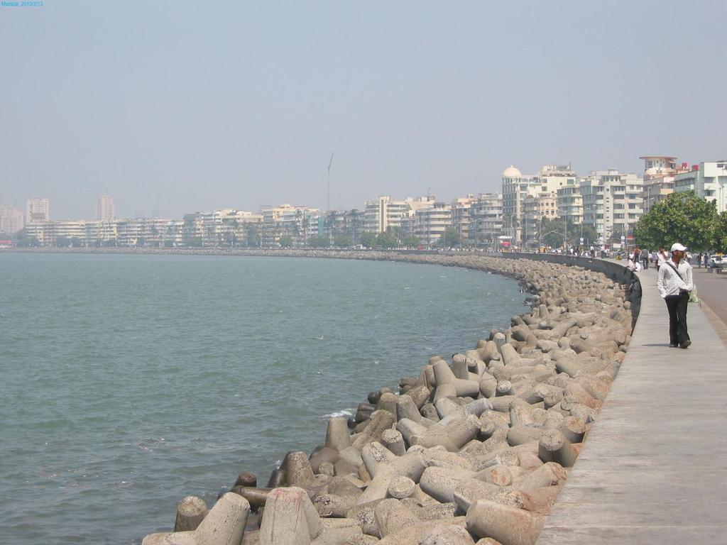
7 Strand
8 Coastal Set-back / Management Lines Legislation An MEC must (a) establish or change coastal set-back lines (i) (ii) (iii) (iv) to protect coastal public property, private property & public safety; to protect the coastal protection zone; to preserve the aesthetic values of the coastal zone; or for any other reason consistent with the objectives of this Act; & (b) prohibit or restrict the building, erection, alteration or extension of structures that are wholly or partially seaward of that coastal setback line. Development set-back lines in the NEMA EIA Regulations 8

9 Western Cape Progression Western Cape set-back line delineation methodology developed and tested (WSP, 2010): Case studies for Milnerton and Langebaan WSP Methodology applied in Overberg District Challenges experienced More pragmatic approach required Lessons learnt from all of these processes have been applied in determining the West Coast coastal set-back / management lines 9
10 Overberg Set-back line Delineation Process Lessons learnt Presented by Tandi Breetzke at IAIA Conference, 2011 Insufficient use of local knowledge Insufficient stakeholder engagement and transparency The need for process amendments wrt Draft Regulations Adverse impacts on property rights Risk projection not realistic 10

11 West Coast District Coastal Set-back / Management Lines Project

12 Refined Methodology Coastal Risk Projections 1:10 (HWM) 1:20 1:50 1:100 Extensive Public Participation Ist Round Consultation informed public of risk and welcomed public opinion as opposed to imposing already determined set-back lines Workshops held along coastline Information made readily available MCC and EMFs used as platform to convey information Revisited terminology used E.g. No further development line 12
13 Coastal Risk Projections
 OFF SHORE WAVE HEIGHT Wave direction &")

 The amount of")

14 Determination of the Physical Processes / Hazard Line (Open coasts) OFF SHORE WAVE HEIGHT Wave direction & height WAVE RUN UP Current wave run up (HWM), short, medium & long term wave run up Scientific Process based No scope for subjective assessments STORM BEACH RETREAT A fixed distance SLR (BRUUN S RULE) The amount of shoreline retreat for short, medium & long term sea level rise LONG TERM BEACH RETREAT Analysis of old aerial photography 14
15 Projected risk... 15
16 Further refinement of methodology Pragmatic Approach DILEMMA: Which of 3 risk projections to use as Coastal Setback??? CoCT conducted their own Setback Line Delineation process Response required to built up nature of coastline Needed pragmatic approach to deal with existing development without infringing on development rights Different approach required between Rural and Urban Areas Different Approach required between coastline and estuaries Testing 5m contour as proxy SOLUTION: Development of risk based coastal overlay zone Risk projections conveyed as risk zones High (1:20) Medium (1:50) Low (1:100) Flood determination for Berg River estuary 16
17 Coastal Set-back / Management Line & Overlay Zones

18 Risk-based Overlay Zones Objective: Use risk projections to inform development decisions Integrate coastal risk information into local planning Allow regulation on a Local level Mechanism: Overlay Zones as a component of town planning & building controls A zone which establishes specific development requirements addressing unique circumstances or situations on a property or group of properties Applies on top of existing zoning or rights 18
19 Overlay Zones Laingville 19
20 Criteria for Coastal Set-back / Management Line In rural areas: The CML follows the littoral active zone or 1:100yr projection, whichever is more conservative. Where existing development occurs seaward of the 1:100yr projection or littoral active zone (CML) in rural areas those developments are treated as development islands. In the case of resorts the island may be delineated around the resort as a whole as it is a functional unit and not individually owned erven. In urban areas: The CML is delineated along the seaward boundaries of property with existing development rights. The CML delineated on landward boundary of Public Open Space with consent from Municipalities In estuaries delineated along 5m contour. 20
21 Coastal Management Line in relation to risk zones - urban 21

22 Coastal Management Line in relation to risk zones - rural 22
23 CSL/CML with Development Islands 23
24 Risk overlay zones for estuaries (urban) 24
25 Risk overlay zones for estuaries (rural) Olifants Estuary 5m amsl 10m amsl Risk Zone 25
")
26 Risk overlay zones for estuaries (combined) Laaiplek 26
 10m amsl contour in estuaries In rural areas: The default CPZ is the 1000m line as specified in ICMA unless the 1:100yr risk projection, littoral active zone or")
27 Criteria for Coastal Protection Zone The long term (100yr) risk projection Inclusive of Littoral active zones Properties that form part of the Coastal Public Property, e.g. Admiralty Reserve Protected Areas All ecologically sensitive areas directly linked to the shoreline Wetlands, lagoons, etc. Heritage sites (i.e. shell middens) 10m amsl contour in estuaries In rural areas: The default CPZ is the 1000m line as specified in ICMA unless the 1:100yr risk projection, littoral active zone or protected areas extend beyond that line. Then the line that is most conservative is applied. In urban areas: The default CPZ is the 100m line as referred to in ICMA unless the 1:100yr risk projection or littoral active zone extends beyond that line. Then the most conservative line is applied. 27
28 Coastal protection zone in urban areas 28
29 Coastal Protection Zone in rural areas 29
30 Overlay Zones Proposed Development Controls
31 Proposed controls Controls proposed per overlay / risk zone Draft controls developed through consultation between authorities Principles: Reduce public liability Reduce risk to human life Prevent intensification of development in risk zone, but allow exercising of existing rights Maintain coastal quality Prevent encroachment that will impact on the integrity of shoreline ecology Inform planned retreat Prevent coastal strip development of rural areas 31
32 Examples of Development Controls Regulate new development, renovations and repairs Structures set back from front boundary Piled or buried seawall Collective/integrated response by adjacent properties or developments Structures elevated on pilings, posts, piers or column foundations Dune rehabilitation Permeable lower floors of structures Relocate mechanical and electrical plants to higher floors Reduce hardened surfaces Manage stormwater on site Barriers that are permeable seawards but not landwards Stop seepage into beach zone / coastal buffer / dune system 32
33 Examples of Development Controls Engineering approval for structures in the risk zones in respect of erosion risk and the ability to withstand wave forces No basements Protect access to the beach for earth moving machinery Defences to comply with relevant legislation Indigenous gardens or no gardens Flood and erosion proof design and location of septic/conservancy tanks and sewer links. Septic/conservancy tanks on landward side of structures Limit size of structure / site coverage relative to flood and erosion exposure and potential impact on coastal public property and public interest in case of failure Protect the structure from falling over and creating secondary effects 33
34 Stakeholder Engagement 34
35 Stakeholder engagement Engagement #1a (initial project notification) Engagement #1b (public meetings) Notification (e.g. adverts, media releases and posters) Authority notification Compilation and distribution of background information document Compilation and maintenance of a stakeholder database Notification (e.g. adverts, media releases and s) Public review of draft hazard lines Compilation and distribution of background information document 11 public workshops Authorities consultation Compilation and maintenance of an Issues & Response table Engagement #2 Notification (e.g. adverts, media releases and s) Public review of draft report Engagement #3 Notification (e.g. adverts, media releases and s) Public review of draft report and draft management/set-back lines Authorities consultation 9 public workshops Engagement #4 Public review of final report and final management/set-back lines 35
36 Implementation of Overlay Zones and CSL/CML
37 Legal Mechanism Options considered ICMA provides for Coastal Set-back Lines but NOT for coastal overlay zones CSL/CML must be delineated in Municipal Zoning Schemes Overlay zones supports CSL and must be applied together ICMA Regulations for setback lines only manage area on seaward side of coastal set-back line Legal mechanisms considered Council resolution Coastal Planning Scheme ito ICMA Municipal Zoning Schemes The Department is in the process of developing Proposed Standard Draft Municipal Zoning Scheme By-law in terms of LUPA Coastal Overlay Zone is a component of the above Implementation of development controls at municipal level through building regulations 37
38 Application of Coastal Set-back / Management Lines and Overlay Zones 38
39 Decision Support Tool Risk based overlay zones inform both placement and design of development and infrastructure Some infrastructure by nature must be placed within coastal zone NEMLA 2 nd Amendment Act of 18 December 2013 make provision for exclusion of activities to obtain environmental authorisation in geographical areas by MEC Overlay zone may be delineated as geographical area Coastal risk = environmental attributes Development controls = environmental standards 39
40 Infrastructure Development 40
41 Elands Bay 41
42 Papendorp (Olifants River estuary) Placement of septic tank outside of risk zone 42
43 Economic Development Doringbaai Aquaculture Development Nodes 43
44 Outcomes of Project High Water Mark Sea-based Risk Projections 1:20 year projection 1:50 year projection 1:100 year projection Estuaries risk projection 5m contour around estuaries 10m contour around estuaries Floodline determination for Berg River Littoral active zone Coastal Protection Zone Coastal Risk Overlay Zone Developmental Controls Coastal Set-back / Management Line Municipal Buy-in Public Support for initiative Preparing CSL/CML for gazetting process ito ICMA 44
45 Consideration of ecological systems 45
46 Benefits of Coastal Set-back / Management Lines Better planning and placement of development and service infrastructure Better designed structures Reduction in maintenance/repair costs Reduction in risk to human lives Maintenance of ecological infrastructure Protection of recreational areas Habitat and biodiversity conservation Informed decision making 46
47 47
48 48
49 Thank you


50 Contact Us Ieptieshaam Bekko; Caren George; Kishan Sankar Coastal Management Unit Environmental Affairs and Development Planning Tel: Fax: /2724/
Randall W. Parkinson, Ph.D., P.G. Institute of Water and Environment Florida International University
 An Update on Adaptation Action Activities Undertaken Since Completion of the City of Satellite Beach (FL) Vulnerability Assessment to Rising Seas (2010) Randall W. Parkinson, Ph.D., P.G. Institute of Water
Sri Lanka has a coastline of km excluding the shoreline of bays and inlets.
 Defining and Demarcating Coastal zones in Sri Lanka Procedure, Challenges and What needs to be done? Dr. Anil Premaratne Director General Coast Conservation Coast Conservation Department Sri Lanka 1 Sri
The Establishment of Coastal Setback Lines for the Overberg District
 Final The Establishment of Coastal Setback Lines for the Overberg District March 2012 A Project for the Western Cape Department of Environmental Affairs & Development Planning Tel: 021-9508517 Email: gerardvw@ssi.co.za
Coastal Viewer Mapping Application:
 Coastal Viewer Mapping Application: MAPPING OF COASTAL PUBLIC PROPERTY, THE COASTAL PROTECTION ZONE BOUNDARIES AND AUDITING OF STRUCTURES ON THE COASTAL PUBLIC PROPERTY 15 May 2014 INTEGRATED COASTAL MANAGEMENT
Coastal Environment. Introduction. 4.1 Coastal Environment. Extent of Coastal Environment
 4 The primary objective (set out in Chapter 2) to be implemented by this Chapter is Objective 2.4 ; the following objectives are also relevant due to the objectives integrated nature: 2.1 Tāngata whenua
Presentation Outline. Project Overview. Sea Level Rise Assessment & Decision Tools. Community Engagement. Tina Whitman, Friends of the San Juans
 Healthy Beaches for People & Fish Sea Level Rise Adaptation Tools for San Juan County, WA Tina Whitman & Andrea MacLennan December 10, 2015 Presentation Outline Project Overview Tina Whitman, Friends of
Application #: TEXT
 TOWN OF FORT MYERS BEACH 2008 PROPOSED COMPREHENSIVE PLAN AMENDMENTS Application #: 2008-13-TEXT Description: Modify the Coastal Management and Future Land Use Elements to reflect the state s new definition
National Perspectives - Portugal. Margarida Almodovar
 National Perspectives - Portugal Margarida Almodovar margarida.almodovar@mam.gov.pt from base line to the external limit of the continental shelf behind 200 miles and according to UNCLOS definitions Economic
(13 July 2018 to date) NATIONAL ENVIRONMENTAL MANAGEMENT ACT 107 OF 1998
 NATIONAL ENVIRONMENTAL MANAGEMENT ACT 107 OF 1998") (13 July 2018 to date) NATIONAL ENVIRONMENTAL MANAGEMENT ACT 107 OF 1998 (Gazette No. 19519, Notice No. 1540. Commencement date: 29 January 1999 [Proc. No. 8, Gazette No. 19703]) ENVIRONMENTAL IMPACT ASSESSMENT
(13 July 2018 to date) NATIONAL ENVIRONMENTAL MANAGEMENT ACT 107 OF 1998 (Gazette No. 19519, Notice No. 1540. Commencement date: 29 January 1999 [Proc. No. 8, Gazette No. 19703]) ENVIRONMENTAL IMPACT ASSESSMENT
Sea-level Rise on Cape Cod: How Vulnerable Are We? Rob Thieler U.S. Geological Survey Woods Hole, MA
 Sea-level Rise on Cape Cod: How Vulnerable Are We? Rob Thieler U.S. Geological Survey Woods Hole, MA Outline Sea-level and coastal processes Past sea-level change Predictions for the future Coastal responses
Planning for coastal hazards in a changing climate
 March 2013 Planning for coastal hazards in a changing climate Catherine Knight, Coastal and Estuary Officer Sharyn French, Manager Land and Natural Environment Presentation overview Stormy past Council
Planning for the Future of Humboldt Bay: Sea Level Rise, Sediment Management, Sand Spits and Salt Marshes. Joel Gerwein
 Planning for the Future of Humboldt Bay: Sea Level Rise, Sediment Management, Sand Spits and Salt Marshes Joel Gerwein Introduction to Humboldt Bay Setting Economy, community, and environment Sediment
Protecting the Storm Damage Prevention and Flood Control Interests of Coastal Resource Areas
 Protecting the Storm Damage Prevention and Flood Control Interests of Coastal Resource Areas Presented by: Massachusetts Department of Environmental Protection & Massachusetts Office of Coastal Zone Management
STAATSKOERANT, 7 APRIL 2017 No Environmental Affairs, Department of/ Omgewingsake, Departement van
 Environmental Affairs, Department of/ Omgewingsake, Departement van 324 National Environmental Management Act (107/1998): Amendment of the Environmental Impact Assessment Regulations Listing Notice (3/2014)
Draft for Discussion 11/11/2016
 Coastal Risk Consulting (CRC) Climate Vulnerability Assessment for Village of Key Biscayne Deliverable 1.1 in Statement of Work. Preliminary Vulnerability Assessment Identifying Flood Hotspots Introduction...
Connecticut Coastal Management Program
 Connecticut Coastal Management Program Fact Sheet for SHORELINE FLOOD AND EROSION CONTROL STRUCTURES What are Shoreline Flood and Erosion Control Structures? The Connecticut General Statutes (CGS) define
SHORELINE MANAGEMENT PLAN FOR OWEN ANCHORAGE AND COCKBURN SOUND SHORELINE MONITORING PLAN
 SHORELINE MANAGEMENT PLAN FOR OWEN ANCHORAGE AND COCKBURN SOUND SHORELINE MONITORING PLAN CHAPTER EIGHT OF DOCUMENT: LONG-TERM SHELLSAND DREDGING, OWEN ANCHORAGE ENVIRONMENTAL MANAGEMENT PROGRAMME JUNE
MyCoast Elaboration of a vision and a strategy for Integrated Coastal Zone Management in Bulgaria
 1. NAME MyCoast Elaboration of a vision and a strategy for Integrated Coastal Zone Management in Bulgaria 2. DESCRIPTION 2.1 The case Bulgaria s coastal territory is distributed among three administrative
TECHNIQUES FOR ASSESSING COASTAL HAZARD AREAS FOR THE GISBORNE DISTRICT COAST
 TECHNIQUES FOR ASSESSING COASTAL HAZARD AREAS FOR THE GISBORNE DISTRICT COAST July 1994 C.R. 1994/12 Jeremy G Gibb 2009 All rights reserved. This work is entitled to the full protection given by the Copyright
Scenarios for the NI coast in the 21 st Century
 Scenarios for the NI coast in the 21 st Century Prof Julian Orford Geography, Archaeology & Palaeoecology Queen s University, Belfast Challenging perspective Living by the coast is good for your health!
Vulnerability Assessment of Coastal Flooding Threats St. Joseph Bay to Apalachee Bay Coastline - Draft
 Vulnerability Assessment of Coastal Flooding Threats St. Joseph Bay to Apalachee Bay Coastline - Draft INTRODUCTION Located on the Gulf coast of Florida, the Apalachee Bay Region includes four coastal
Redcliffs Park Coastal inundation and coastal erosion
 48 Hereford Street Christchurch 8013 Attention: Deb Taylor Dear Deb 1 Introduction The (MoE) are looking to relocate Redcliffs School to a new school development at and are currently undertaking their
Cross Boundary Issues
 6 Cross Boundary Issues 6 C R O S S B O U N D A R Y I S S U E S 6.1 Introduction The effects of an activity within the coastal marine area are often felt in adjacent areas, outside of the immediate vicinity
SPLAN-Natura Towards an integrated spatial planning approach for Natura th January, 2017 Brussels. Commissioned by DG Environment
 SPLAN-Natura 2000 Towards an integrated spatial planning approach for Natura 2000 Commissioned by DG Environment 17 th January, 2017 Brussels V. Simeonova (Ph.D.) Drivers towards integrating Biodiversity
Operative Chapter 13 Natural Hazards 31 January 2015 NATURAL HAZARDS
 CHAPTER 13: NATURAL HAZARDS 13.0 INTRODUCTION Natural hazards have the potential to damage property, infrastructure and ecosystems, and threaten health and safety. Remedying the damage can cost individuals
Coastal Processes 101 & The Regs. Greg Berman (Woods Hole Sea Grant & Cape Cod Cooperative Extension)
") Coastal Processes 101 & The Regs Greg Berman (Woods Hole Sea Grant & Cape Cod Cooperative Extension) March 26, 2019 Coastal Processes 101 & The Regs Outline: ~15 min talk Coastal Processes What is Erosion?
Coastal Processes 101 & The Regs Greg Berman (Woods Hole Sea Grant & Cape Cod Cooperative Extension) March 26, 2019 Coastal Processes 101 & The Regs Outline: ~15 min talk Coastal Processes What is Erosion?
Developed in Consultation with Florida Educators
 Developed in Consultation with Florida Educators Table of Contents Next Generation Sunshine State Standards Correlation Chart... 7 Benchmarks Chapter 1 The Practice of Science...................... 11
21st International Conference of The Coastal Society LEGAL AND POLICY IMPACTS OF SEA LEVEL RISE TO BEACHES AND COASTAL PROPERTY
 21st International Conference of The Coastal Society LEGAL AND POLICY IMPACTS OF SEA LEVEL RISE TO BEACHES AND COASTAL PROPERTY Megan Higgins, Roger Williams University School of Law and RI Sea Grant Legal
Country Fiche Sweden Updated May 2018
 Country Fiche Sweden Updated May 2018 1. General information 2 the territorial sea (12-nm zone) 70,000 km2 the Exclusive Economic Zone 60,000 km2 the EEZ is limited to the central line between adjacent
Assessing Sea Level Rise, Storm Surge and Flooding Risks at the Ogunquit Wastewater Treatment Facility COMMITMENT & INTEGRITY DRIVE RESULTS
 Assessing Sea Level Rise, Storm Surge and Flooding Risks at the Ogunquit Wastewater Treatment Facility September 27, 2012 Presentation Outline Reasons for the Study Sea Level Rise, Storm Surge & Flooding
Lorna V Inniss, Ph.D SAGE Workshop, New York City
 Lorna V Inniss, Ph.D SAGE Workshop, New York City 2014-05-21 Why me? The globally recognized success of the Barbados ICZM programme has generated requests for technical assistance and CD from many Governments
POLISH LAW ON MSP. Andrzej Cieślak Maritime Office in Gdynia
 POLISH LAW ON MSP Andrzej Cieślak Maritime Office in Gdynia Preconditions Ownership/management of allsea areas (internal sea waters, territorial sea, EEZ): the State, and in its name the Minister responsible
Coastal Guide ICZM Information System
 Coastal Guide ICZM Information System 1. Key data Project title: Implementing alternative strategies in Irish beach and dune management: involvement in sustainable coastal development Country: Ireland
BURGAS CASE STUDY: LAND-SEA INTERACTIONS. Dr. Margarita Stancheva
 BURGAS CASE STUDY: LAND-SEA INTERACTIONS Dr. Margarita Stancheva Name of presentation NEED FOR COHERENCE BETWEEN LAND AND SEA ACTIVITIES Name presenter Burgas is the fourth largest city in Bulgaria and
Designing Networks of Marine Protected Areas in DFO s Three Atlantic Bioregions
 Designing Networks of Marine Protected Areas in DFO s Three Atlantic Bioregions Presentation for Indigenous Protected Areas Workshop Max Westhead, DFO and Adrian Gerhartz-Abraham, Dalhousie March 29, 2017
4 Project Alternatives
 BSD Deepening EIR Page 50 4 Project Alternatives In terms of the EIA regulations (Regulation 6 (1) (d) GN No. R1183, dated 5 September 1997) and NEMA, the applicant is required to demonstrate that alternatives
Coastal Erosion & Climate Change: PRIDE 2005 Towards an Alaska Wind/Wave Climatology
 Coastal Erosion & Climate Change: PRIDE 2005 Towards an Alaska Wind/Wave Climatology 2 nd PRIDE Workshop August 9-10, 2005 David Atkinson, Int l Arctic Research Center, Univ. Of Alaska-Fairbanks James
Phillip Island Nature Parks Coastal Process Study 8 October 2014
 Phillip Island Nature Parks Coastal Process Study 8 October 2014 Project Overview Coastal Geology Basaltic and fragmented lavas, granite at Pyramid Rock and Cape Woolamai Weathered basalt (>10m thick)
Mapping ecosystem services provided by benthic habitats in the European Atlantic Ocean
 Mapping and Assessment Ecosystem Services and Links to Good Environmental Status Mapping ecosystem services provided by benthic habitats in the European Atlantic Ocean Ibon Galparsoro, Angel Borja and
Country Fiche Lithuania
 Country Fiche Lithuania Updated June 2018 1. General information The Lithuanian maritime space is delimited by the Decree of the Government of the Republic of Lithuania of 6 December, 2004, No. 1597 and
Newsletter # 2. Pilot sites in Greece. December 2018
 A HarmonizEd framework to Mitigate coastal EroSion promoting ICZM protocol implementation Newsletter # 2 December 2018 View of a beach in Ammolofi ( Paggaio Municipality ) Pilot sites in Greece 1. Name
INSPIRE Basics. Vlado Cetl European Commission Joint Research Centre. https://ec.europa.eu/jrc/
 INSPIRE Basics Vlado Cetl European Commission Joint Research Centre https://ec.europa.eu/jrc/ Serving society Stimulating innovation Supporting legislation Outline SDI? Why European SDI? INSPIRE Policy
of the Resource Management Act 1991 ("Act") (ENV-2013-AKL )
 (ENV-2013-AKL )") BEFORE THE ENVIRONMENT COURT IN THE MATTER of the Resource Management Act 1991 ("Act") AND IN THE MATTER of a Notice of Motion under section 87G of the Act requesting the granting of resource consents
BEFORE THE ENVIRONMENT COURT IN THE MATTER of the Resource Management Act 1991 ("Act") AND IN THE MATTER of a Notice of Motion under section 87G of the Act requesting the granting of resource consents
WELCOME & INTRODUCTION
 MPA Management Capacity Building Training Module 1: WELCOME & INTRODUCTION Participants Distinguished Guests Welcome Site Overviews of MPAs represented Overview of Training Program What are Today s Objectives?
Delta Flood Protection Strategy Update. May 16, 2016
 Delta Flood Protection Strategy Update May 16, 2016 Presentation Overview 1. Background 2. Understanding the Dike Reaches/Issues 3. Future Dike Improvements 4. Next Steps Boundary Bay Village March 10,
5.2. Historic heritage. Photo: Vaughan Homestead, Long Bay Regional Park, Auckland. (Source: ARC). Historic heritage
. Historic heritage") Photo: Vaughan Homestead, Long Bay Regional Park, Auckland. (Source: ARC). 274 Hazards and heritage Contents 5.2 Introduction 276 monitoring programmes 276 The state of historic heritage 277 Heritage items
Photo: Vaughan Homestead, Long Bay Regional Park, Auckland. (Source: ARC). 274 Hazards and heritage Contents 5.2 Introduction 276 monitoring programmes 276 The state of historic heritage 277 Heritage items
RESPONDING TO NUISANCE FLOODING OF COASTAL HIGHWAYS: OPTIONS FOR MUNICIPALITIES
 RESPONDING TO NUISANCE FLOODING OF COASTAL HIGHWAYS: OPTIONS FOR MUNICIPALITIES Read Porter Marine Affairs Institute / Rhode Island Sea Grant Legal Program Climate Adaptation Academy Workshop: Legal Issues
Use of Elevation Data in NOAA Coastal Mapping Shoreline Products. Coastal GeoTools April 1, 2015
 Use of Elevation Data in NOAA Coastal Mapping Shoreline Products Coastal GeoTools April 1, 2015 - NOAA s Coastal Mapping Program & CUSP - Shoreline Uses, Delineation Issues, Definitions - Current Extraction
Cliff stabilisation. Adaptation Option Climate-ADAPT
 Cliff stabilisation Adaptation Option Climate-ADAPT Cover design: EEA Cover photo: EEA Layout: EEA Legal notice The contents of this publication do not necessarily reflect the official opinions of the
Flood Risk Mapping and Forecasting in England
 Flood Risk Mapping and Forecasting in England Mark Franklin Environment Agency, England NORDESS Workshop on Risk Assessment and Acceptable Risk Outline Flood risk in England Who we are and how we work
Adaptation to Sea Level Rise A Regional Approach
 Adaptation to Sea Level Rise A Regional Approach Project Partners: in Saco Bay, ME Peter Slovinsky, Marine Geologist Maine Geological Survey, Department of Conservation Project Funding from: Saco Bay Hazards
Section 145 Climate Change and Sea Level Rise
 Section 145 Climate Change and Sea Level Rise A. Definitions Rhode Island Coastal Resources Management Program 1. Climate is the long-term weather average observed within a geographic region, and climate
Coastal Processes 101. Greg Berman (Woods Hole Sea Grant & Cape Cod Cooperative Extension)
") Coastal Processes 101 Greg Berman (Woods Hole Sea Grant & Cape Cod Cooperative Extension) January 23, 2019 Coastal Processes 101 Outline: ~30 min talk Coastal Processes What is Erosion? Value of the Ecosystem
Coastal Processes 101 Greg Berman (Woods Hole Sea Grant & Cape Cod Cooperative Extension) January 23, 2019 Coastal Processes 101 Outline: ~30 min talk Coastal Processes What is Erosion? Value of the Ecosystem
Wetland Programmes. Biodiversity assessments in determining wetland conservation priorities: a catchment approach. Dr. Piet-Louis Grundling
 CHIEF DIRECTORATE NATURAL RESOURCE MANAGEMENT PROGRAMMES: Wetland Programmes Biodiversity assessments in determining wetland conservation priorities: a catchment approach Dr. Piet-Louis Grundling Environmental
The Use of Geographic Information Systems to Assess Change in Salt Marsh Ecosystems Under Rising Sea Level Scenarios.
 The Use of Geographic Information Systems to Assess Change in Salt Marsh Ecosystems Under Rising Sea Level Scenarios Robert Hancock The ecological challenges presented by global climate change are vast,
Draft exercise for share fair at Bozeman workshop only. This exercise is not ready for distribution. Please send helpful suggestions to
 Draft exercise for share fair at Bozeman workshop only. This exercise is not ready for distribution. Please send helpful suggestions to foleyd@plu.edu Figure list 1. Trailer photograph 2. Location map
What is Spatial Planning?
 Spatial Planning in the context of the Responsible Governance of Tenure What is Spatial Planning? Text-only version This course is funded by the European Union through the EU-FAO Improved Global Governance
DESIGN ENGINEERING ANALYSIS FOR TERMINAL GROIN LENGTH
 APPENDIX F DESIGN ENGINEERING ANALYSIS FOR TERMINAL GROIN LENGTH (Prepared by Olsen Associates, Inc.) DRAFT Environmental Impact Statement Village of Bald Head Island Shoreline Protection Project Brunswick
EUROSION: Coastal erosion measures, knowledge and results acquired through 60 studies
 Herrier J.-L., J. Mees, A. Salman, J. Seys, H. Van Nieuwenhuyse and I. Dobbelaere (Eds). 2005. p. 421-431 Proceedings Dunes and Estuaries 2005 International Conference on Nature Restoration Practices in
Adapting to Rising Sea Level & Extreme Weather Events:
 Adapting to Rising Sea Level g & Extreme Weather Events: A Florida Perspective Randall W. Parkinson, Ph.D., P.G. President RWParkinson Consulting, Inc. Melbourne, Florida & Administrator Space Coast Climate
Seaton to Seaton Hole SUMMARY OF PREFERRED PLAN RECOMMENDATIONS AND JUSTIFICATION
 Location reference: Policy Unit reference: Plan: Seaton to Seaton Hole 6a29 and 6a30 SUMMARY OF PREFERRED PLAN RECOMMENDATIONS AND JUSTIFICATION The large number of properties and assets at risk in the
Center for Spatial Data Infrastructures and Land Administration Department of Geomatics, University of Melbourne. Content
 Heri SUTANTA, Abbas RAJABIFARD, Ian BISHOP Center for Spatial Data Infrastructures and Land Administration Department of Geomatics, University of Melbourne Content Introduction Coastal Urban Environment
DIVISION OF COASTAL MANAGEMENT TO STUDY CURRENT LONG-TERM EROSION RATES ADJACENT TO TERMINAL GROINS
 DIVISION OF COASTAL MANAGEMENT TO STUDY CURRENT LONG-TERM EROSION RATES ADJACENT TO TERMINAL GROINS North Carolina Department of Environmental Quality Division of Coastal Management February 22, 2018 N.
City of Manitou Springs
 March 2018 City of Manitou Springs Implementing Land Use tools to reduce and mitigate natural hazard risk Context & History Past Present Historic homes Older infrastructure Hillside development Creekside
Heather Schlosser Army Corps of Engineers Coastal Studies Group August 28, 2008
 Got sand? Regional Sediment Management in Orange County Heather Schlosser Army Corps of Engineers Coastal Studies Group August 28, 2008 Regional Sediment Management Regional sediment management recognizes
Implementing Rio+20: Integrated Planning For Sustainable Coastal Area Management In the Caribbean Region
 Expert Group Meeting Implementing Rio+20: Integrated Planning For Sustainable Coastal Area Management In the Caribbean Region Address by Ronny Jumeau Seychelles Ambassador for Climate change And SIDS Issues
CHAPTER 4 HIGH LEVEL SPATIAL DEVELOPMENT FRAMEWORK (SDF) Page 95
 Page 95") CHAPTER 4 HIGH LEVEL SPATIAL DEVELOPMENT FRAMEWORK (SDF) Page 95 CHAPTER 4 HIGH LEVEL SPATIAL DEVELOPMENT FRAMEWORK 4.1 INTRODUCTION This chapter provides a high level overview of George Municipality s
CHAPTER 4 HIGH LEVEL SPATIAL DEVELOPMENT FRAMEWORK (SDF) Page 95 CHAPTER 4 HIGH LEVEL SPATIAL DEVELOPMENT FRAMEWORK 4.1 INTRODUCTION This chapter provides a high level overview of George Municipality s
Background to the PFRA European Overview - UC9810.5b
 Background to the PFRA European Overview - UC9810.5b The individual Member State Reports reflect the situation as reported by the Member States to the European Commission in 2012 The situation in the MSs
Opening their Shells Getting commercial clammers involved in marine spatial planning
 Opening their Shells Getting commercial clammers involved in marine spatial planning Ed Lewandowski Coastal Communities Development Specialist University of Delaware/Delaware Sea Grant Highlights Background
GIS in Community & Regional Planning
 GIS in Community & Regional Planning The The role role of of GIS GIS in in Re-writing the the Zoning Bylaw for for the the City City of of Vernon LandInfo Technologies Presentation Overview The GIS Initiative
CHAPTER GEOLOGICALLY HAZARDOUS AREAS Applicability Regulations.
 CHAPTER 19.07 GEOLOGICALLY HAZARDOUS AREAS 19.07.010 Applicability. Geologically hazardous areas may pose a threat to the health and safety of citizens when incompatible development is sited in areas of
Using Remote Piloted Aircraft for Seawall Condition Assessment
 Using Remote Piloted Aircraft for Seawall Condition Assessment Moreton Bay Regional Council Shamim Yazdani Senior Engineer - Stormwater Planning DJI Industries Phantom FC-40 remotely-piloted aircraft 1
GIS Geographical Information Systems. GIS Management
 GIS Geographical Information Systems GIS Management Difficulties on establishing a GIS Funding GIS Determining Project Standards Data Gathering Map Development Recruiting GIS Professionals Educating Staff
Scotland s centre of expertise for waters. Dynamic Coast - National Coastal Change Assessment: Defence Asset Database
 Scotland s centre of expertise for waters Dynamic Coast - National Coastal Change Assessment: Defence Asset Database Scotland s centre of expertise for waters Published by CREW Scotland s Centre of Expertise
The Coastal Change Analysis Program and the Land Cover Atlas. Rebecca Love NOAA Office for Coastal Management
 The Coastal Change Analysis Program and the Land Cover Atlas Rebecca Love NOAA Office for Coastal Management Natural Infrastructure = Greater Resilience NOAA C-CAP Regional Land Cover and Change coast.noaa.gov/digitalcoast/data/ccapregional
Shoreline and Climate Change Adaptation Alternatives for The Letter Parcel, Bolinas Lagoon
 Shoreline and Climate Change Adaptation Alternatives for The Letter Parcel, Bolinas Lagoon Scenic shoreline vista of Bolinas Lagoon and ridges, from Letter Parcel, March 2016 Peter Baye, Coastal Ecologist
Country reports. Israel did not establish an Exclusive Economic Zone. Consequently, its jurisdiction is restricted to the Israeli territorial waters.
 Country reports I. ISRAEL Disclaimer This document has not been adopted by the European Commission and should therefore not be relied upon as a statement of the European Commission. The purpose of this
HELSINKI COMMISSION Baltic Marine Environment Protection Commission
 HELSINKI COMMISSION Baltic Marine Environment Protection Commission HELCOM RECOMMENDATION 24/10 Adopted 25 June 2003, having regard to Article 20, Paragraph 1 b) of the 1992 Helsinki Convention IMPLEMENTATION
A Comparison of the Social Valuation of Ecosystem Services in Urban and Rural Contexts
 A Comparison of the Social Valuation of Ecosystem Services in Urban and Rural Contexts Jarrod L. Loerzel College of Charleston Zachary D. Cole University of Florida Presentation Map 1. What is SolVES?
REPORT. Coastal Inundation Hazard Zone Mapping. Addendum to Coastal Protection Areas Re-assessment Stage Two
 REPORT Coastal Inundation Hazard Zone Mapping Addendum to Coastal Protection Areas Re-assessment Stage Two Prepared for Prepared by Date Job Number 851833 Distribution: (FILE) 1 copy 1 copy Table of contents
Croatian physical planning system and strategic approach to MSP
 W 1/7 Past two years all over the Europe: case studies 2 Croatian physical planning system and strategic approach to MSP Vesna Marohnić Kuzmanović Head of Department Croatian Institute for Spatial Development
Newsroom: 'Shifting Seas' Symposium at RWU Law
 Roger Williams University DOCS@RWU Life of the Law School (1993- ) Archives & Law School History 11-16-2012 Newsroom: 'Shifting Seas' Symposium at RWU Law Roger Williams University School of Law Follow
SEGMENTED BREAKWATERS AND THEIR USE IN COASTAL LOUISIANA
 SEGMENTED BREAKWATERS AND THEIR USE IN COASTAL LOUISIANA Prepared by: Louisiana Coastal Protection and Restoration Authority Engineering Division March 2016 The geology of Louisiana s coastal zone is intimately
TERRITORIAL IMPACT ASSESSMENT: AN APPROACH TO IMPROVE THE VERTICAL AND HORIZONTAL INTEGRATION OF EU POLICIES
 TERRITORIAL IMPACT ASSESSMENT: AN APPROACH TO IMPROVE THE VERTICAL AND HORIZONTAL INTEGRATION OF EU POLICIES Naja Marot & Mojca Golobič Biotehnical Faculty, University of Ljubljana, Slovenia RSA Workshop
MISSISSIPPI COASTAL IMPROVEMENTS
 MISSISSIPPI COASTAL IMPROVEMENTS PROGRAM (MsCIP) Comprehensive Barrier 237 27 200 237 27 200 Island 237 Restoration 27 200 Plan 80 9 27 252 74.59 255 255 255 0 0 0 63 63 63 3 32 22 239 65 53 0 35 20 2
BURGAS CASE STUDY: LAND-SEA INTERACTIONS
 BURGAS CASE STUDY: LAND-SEA INTERACTIONS Dr. Margarita Stancheva IO-BAS, Bulgaria Name of presentation CROSS BORDER MARITIME SPATIAL PLANNING IN THE BLACK SEA ROMANIA AND BULGARIA (MARSPLAN BS) Project
Sea Level Rise Study Summary Town of South Bethany
 Sea Level Rise Study Summary Town of South Bethany This presentation was prepared by Anchor QEA for the Town of South Bethany using Federal Funds under award NA14 NOS 419 0123 from the Delaware Coastal
Coasts Key Word Glossary
 Coasts Key Word Glossary Abrasion Also known as corrosion. It is the wearing away of the cliff by sand, fragments of rock and boulders that are being hurled at the cliff by the waves. It causes grinding
Natura 2000 and spatial planning. Executive summary
 Natura 2000 and spatial planning Executive summary DISCLAIMER The information and views set out in this study are those of the author(s) and do not necessarily reflect the official opinion of the Commission.
Coastal Vulnerability and Risk Parameters
 European Water 11/12: 3-7, 2005. 2005 E.W. Publications Coastal Vulnerability and Risk Parameters E. Doukakis National Technical University of Athens-Dept. of Rural and Surveying Engineering, Lab. of Higher
Marine Spatial Planning: A Tool for Implementing Ecosystem-Based Management
 Marine Spatial Planning: A Tool for Implementing Ecosystem-Based Management Steven Murawski, Ph.D., Ecosystem Goal Team Lead National Oceanic and Atmospheric Administration NOAA November 16, 2009 1 To
Tony Pratt, DNREC to The Center for the Inland Bays Scientific and Technical Advisory Committee. August 21, 2009
 Sea Level Rise in Delaware Presented by Tony Pratt, DNREC to The Center for the Inland Bays Scientific and Technical Advisory Committee August 21, 2009 Sea level has been fluctuating ever since there have
The Governance of Land Use
 The planning system Levels of government and their responsibilities The Governance of Land Use Country fact sheet Germany Germany is a federal country with four levels of government. Below the national
Sediment Management in the Coastal Bays
 Sediment Management in the Coastal Bays Introduction Need for ecosystem view of sediment management in Coastal Bays Island loss and restoration Navigation needs Habitat Trade offs Living Shoreline Requirements
Linking the value of ocean space and marine ecosystem to coastal reclamation planning: A case study of Xiamen
 Linking the value of ocean space and marine ecosystem to coastal reclamation planning: A case study of Xiamen Benrong Peng, PhD Coastal and Ocean Management Institute, Xiamen University (COMI) Nov. 20,
Regional-scale understanding of the geologic character and sand resources of the Atlantic inner continental shelf, Maine to Virginia
 Regional-scale understanding of the geologic character and sand resources of the Atlantic inner continental shelf, Maine to Virginia Workshop on Dredging, Beach Nourishment and Bird Conservation Atlantic
Marine Spatial Planning Leslie-Ann McGee Battelle Memorial Institute
 Marine Spatial Planning Leslie-Ann McGee Battelle Memorial Institute Rev061708 1 Marine Spatial Planning What is it? Why is it different? Where is it currently being employed? What is happening in the
Addendum to the Essex and South Suffolk Second Generation Shoreline Management Plan
 Addendum to the Essex and South Suffolk Second Generation Shoreline Management Plan September 2012 CONTENTS 1. Introduction 1 2. Changes in saltmarsh habitat 1 3. Preferred managed realignment policy options
Overview of Methods. Terrestrial areas that are most important for conservation Conservation
 Overview of Methods The goal of the Western Lake Erie Coastal Conservation Vision project (WLECCV) is to define where we should be working locally to optimally achieve regional conservation impact. The
South Carolina BMA. Jurisdictional Line Revisions
 South Carolina BMA Jurisdictional Line Revisions 40 Year Retreat Policy A forty year policy of retreat from the shoreline is established. The department must implement this policy and utilize the best