Coastal Evolution in Sedimentary Areas in Greenland
|
|
|
- Norman Carroll
- 5 years ago
- Views:
Transcription


1 Coastal Evolution in Sedimentary Areas in Greenland Mette Bendixen P h D s t u d e n t DANCORE Young Professionals Day Dias 1
2 Outline Motivation State of the art on Arctic coasts Purpose of my Phd Presentation of the two study areas Results Conclusion

3 FOR PERMAFROST (CENPERM) Motivation: Climate is changing warming in the Arctic is stronger Dias 3

4 FOR PERMAFROST (CENPERM) Motivation: Climate is changing glaciers are retreating Bjørk et al DOI: /NGEO1481 Dias 4

5 FOR PERMAFROST (CENPERM) Motivation: Climate is changing sea ice extent is thinning and diminishing Peter Wadhams, Polar Ocean Physics Group, Cambridge Dias 5
6 FOR PERMAFROST (CENPERM) Climate is changing and sets off several processes: Increasing pressure on coastal areas Dias 6

7 FOR PERMAFROST (CENPERM) Climate is changing and sets off several processes: Increasing pressure on coastal areas Changing depositional patterns Shifting coastal fluxes to the oceans Altering sediment and nutrient pathways Dias 7

8 Arctic coasts: tundra Coastal plain in Alaska and Siberia Dias 8

9 Coastal plain in Alaska and Siberia Dias 9

10 State of art on Arctic coasts Coastal plain Greenland Dias 10
11 FOR PERMAFROST (CENPERM) State of art on Arctic coasts Lantuiet et al DOI /s Dias 11

12 FOR PERMAFROST (CENPERM) State of art on Arctic coasts m/yr m/yr m/yr m/yr?! Lantuiet et al DOI /s Dias 12
13 Aims Quantify rates (m 3 /y) of shoreline changes and fluxes of eroded sediment and nutrient in permafrost-affected areas in Greenland Dias 13
14 Aims Quantify rates (m 3 /y) of shoreline changes and fluxes of eroded sediment and nutrient in permafrost-affected areas in Greenland Specify the parameters responsible for shoreline changes in a warming Arctic climate Dias 14


15 Study areas sedimentary coasts Young Sound Continuous permafrost South-eastern Disko Island Discontinuous permafrost Dias 15
 Study area")

")
16 FOR PERMAFROST (CENPERM) Study area sedimentary coasts, Disko Island, W Gr. Sedimentary coasts ~20 % (10% deltas) Dias 16

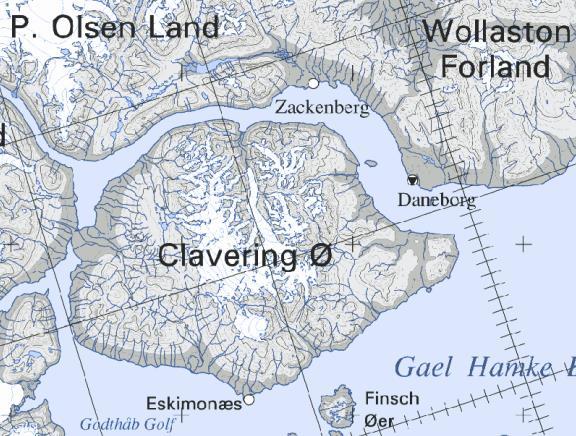
17 FOR PERMAFROST (CENPERM) Study area sedimentary coasts, Young Sound, NE Gr. Dias 17
18 Aim 1 Quantify rates of shoreline changes and sediment and nutrient fluxes in permafrost-affected areas Identification of geomorphological features - beach ridges, tombolos, pocket beaches, spits, deltas Identification of coastal changes Methods Aerial photos and satellite images Coastal change detection method Dias 18

19 Results Morphological mapping, Disko Dias 19
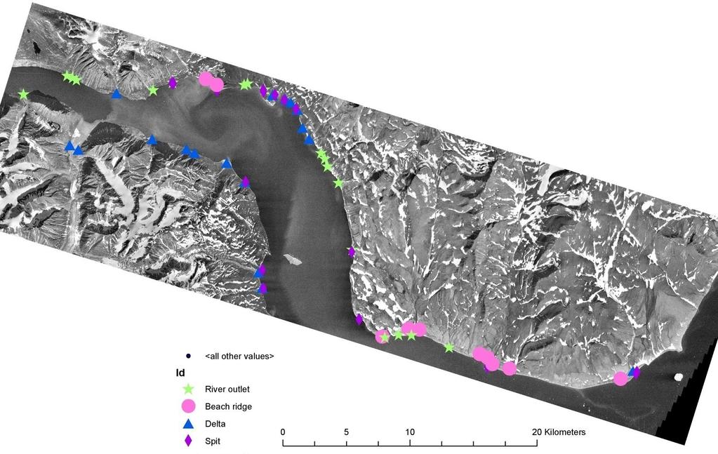
20 Results Morphological mapping, Young Sound Dias 20
21 Methods detection of shoreline changes 1932 Dias 21
22 Methods detection of shoreline changes Dias 22


23 Methods detection of shoreline changes 1932 Dias

24 Methods detection of shoreline changes Aerial photos Rectification and georeferencing Shoreline detection Shoreline changes Dias 24


25 Results Detection of shoreline changes Disko Island 1964: aerial photo 1985: orthophoto Skansen 2012: satellite image Dias 25


26 Results Detection of shoreline changes Skansen, Disko Island 1964 Skansen Dias 26
27 Results Detection of coastal changes Zackenberg delta CENTER FOR PERMAFROST (CENPERM) Meters Dias 27
 2012 2012 2011 2011 2010 2008 2000 1989 1973 0 250 500 1.")
28 Preliminary results Detection of coastal changes Zackenberg delta CENTER FOR PERMAFROST (CENPERM) Meters Dias 28
 2012 2012 2011 2011 2010 2008 2000 1989 1973 0 250 500 1.")
29 Preliminary results - Detection of coastal changes Zackenberg delta CENTER FOR PERMAFROST (CENPERM) Meters 19 m Dias 29
30 Aim 2 Specify the parameters responsible for shoreline changes in a warming Arctic climate Methods Identification of parameters influencing coastal changes - strengths and stresses Dias 30
31 Aim 2 Specify the parameters responsible for shoreline changes in a warming Arctic climate Methods Identification of parameters influencing coastal changes Dias 31
32 Results strengths stresses Dias 32

33 Results strengths Topographic profiles Cliff height and orientation Active layer depth Ice content Grain size Organic content stresses Bathymetry Wave characteristics Water levels incl. tide Sea ice Dias 33

34 Results Strength of the coast Meters Dias 34

35 Results Strength of the coast, active layer depth Dias 35
36 Take home message Sedimentary coasts in Greenlands response to climate changes erosion, aggredation, or reworking? Dias 36
37 Take home message Sedimentary coasts in Greenlands response to climate changes eroding, accreting, or reworking Dias 37

38 Questions, inputs, and comments are very welcome! Dias 38
Oceanography. Oceanography is the study of the deep sea and shallow coastal oceans.
 Oceanography Oceanography is the study of the deep sea and shallow coastal oceans. Studying the Ocean Floor To determine the shape and composition of the ocean floor, scientists use techniques such as
GIS compilation of coastline variability spanning 60 years in the Mackenzie Delta and Tuktoyaktuk in the Beaufort Sea
 GEOLOGICAL SURVEY OF CANADA OPEN FILE 7685 GIS compilation of coastline variability spanning 60 years in the Mackenzie Delta and Tuktoyaktuk in the Beaufort Sea S. Hynes, S.M. Solomon, and D. Whalen 2014
Erosion and Accretion Patterns along the Danish Shores
 Department of Geosciences and Natural Resource Management rosion and Accretion Patterns along the Danish Shores Aart Kroon Danish Coasts and Climate Adaptation (COADAPT) Climate Change and Coastal Adaptation
The Marine Environment
 The Marine Environment SECTION 16.1 Shoreline Features In your textbook, read about erosional landforms, beaches, estuaries, longshore currents, and rip currents. For each statement below, write true or
Importance of Understanding Coastal Landforms
 Importance of Understanding Coastal Landforms Costa Concordia Shipwreck, Isola del Giglio, Italy Depositional Coastal Landforms Can interpret landforms in light of geomorphic processes, both terrestrial
5. MANY COASTAL COMMUNITIES AND FACILITIES WILL FACE INCREASING EXPOSURE TO STORMS.
 5. MANY COASTAL COMMUNITIES AND FACILITIES WILL FACE INCREASING EXPOSURE TO STORMS. Climate change is altering the Arctic coastline and much greater changes are projected for the future as a result of
The Marine Environment
 The Marine Environment SECTION 16.1 Shoreline Features In your textbook, read about erosional landforms, beaches, estuaries, longshore currents, and rip currents. For each statement below, write or. 1.
4. The map below shows a meandering stream. Points A, B, C, and D represent locations along the stream bottom.
 1. Sediment is deposited as a river enters a lake because the A) velocity of the river decreases B) force of gravity decreases C) volume of water increases D) slope of the river increases 2. Which diagram
EARTH SURFACE PROCESSES AND SEDIMENTATION!
 Sed and Strat EARTH SURFACE PROCESSES AND SEDIMENTATION! 2/27 Lecture 7- Exposure: Weathering and the Sediment Factory 3/04 Lecture 8 - Rivers and Landscapes 3/06 Lecture 9 - Waves (not Tides) 3/11 Lecture
Permafrost-influenced Geomorphic Processes
 Section 4 Permafrost-influenced Geomorphic Processes Geomorphic processes vary greatly among ecoregions in northern Alaska, extending from the Beaufort Sea coast to the Brooks Range (Figure 4.1). Regional
Product Guide: TerraSAR-X derived Cliff Top Retreat
 Product Guide: TerraSAR-X derived Cliff Top Retreat Stettner, Samuel 1), Bartsch, Annett 2),3), Widhalm, Barbara 2,3), Heim, Birgit 1), Günther, Frank 1), Morgenstern, Anne 1) 1) Alfred-Wegener-Institut,
The Coast: Beaches and Shoreline Processes
 1 2 3 4 5 6 7 8 9 The Coast: es and Shoreline Processes Trujillo & Thurman, Chapter 10 Oceanography 101 Chapter Objectives Recognize the various landforms characteristic of beaches and coastal regions.
The Coast: Beaches and Shoreline Processes Trujillo & Thurman, Chapter 10
 The Coast: es and Shoreline Processes Trujillo & Thurman, Chapter 10 Oceanography 101 Chapter Objectives Recognize the various landforms characteristic of beaches and coastal regions. Identify seasonal
COASTAL GEOLOGIC HAZARDS AND SEA-LEVEL RISE: CLIMATE CHANGE IN RHODE ISLAND
 COASTAL GEOLOGIC HAZARDS AND SEA-LEVEL RISE: CLIMATE CHANGE IN RHODE ISLAND Sakonnet Preservation Association Annual Meeting 9 July 2013 Jon C. Boothroyd 1,2 and Bryan A. Oakley 3 (1) Rhode Island Geological
Unit 1: Water Systems on Earth Chapter 2
 Unit 1: Water Systems on Earth Chapter 2 Create a mind map with the driving question, Why are Oceans Important? Remember: Why are oceans so important? Why are oceans so important? Primary water source
Active Coastal Processes in the Lubec Embayment
 The Lubec Embayment Maine Geologic Facts and Localities August, 1998 Active Coastal Processes in the Lubec Embayment 44 49 50.51 N, 66 59 34.16 W Text by Joseph T. Kelley, Department of Agriculture, Conservation
Developed in Consultation with Florida Educators
 Developed in Consultation with Florida Educators Table of Contents Next Generation Sunshine State Standards Correlation Chart... 7 Benchmarks Chapter 1 The Practice of Science...................... 11
Supplemental Slides. Shore: Junction of Land & Water. Junction of Land & Water. Sea Level Variations. Shore vs. Coast. Sea Level Variations
 Shore: Junction of Land & Water Supplemental Slides Sediments come off land Most get dumped at the beach Sediment interacts with ocean waves and currents Junction of Land & Water Features: Breaking waves,
Shore: Junction of Land & Water. Sediments come off land Most get dumped at the beach Sediment interacts with ocean waves and currents
 Shore: Junction of Land & Water Supplemental Slides Sediments come off land Most get dumped at the beach Sediment interacts with ocean waves and currents Junction of Land & Water Features: Breaking waves,
SHORELINE AND BEACH PROCESSES: PART 2. Implications for Coastal Engineering
 SHORELINE AND BEACH PROCESSES: PART 2 Implications for Coastal Engineering Objectives of the lecture: Part 2 Show examples of coastal engineering Discuss the practical difficulties of ocean engineering
A BEACH IS A BEACH. Or Is It? Hawaii. St. Croix, US Virgin Islands
 A BEACH IS A BEACH Or Is It? Pt. Reyes, California Western Florida Hawaii AGI What is a beach? Eastern Maine A beach is a strip of shoreline washed by waves and tides. Crane Key, Florida Bay St. Croix,
Snow cover measurement and variation analysis
 Snow cover measurement and variation analysis Konosuke Sugiura / Associate Professor, University of Toyama Fig.1 The rapid progression of snow cover extent in the northern hemisphere in October 2012. Red:
UNIT 1: WATER SYSTEMS ON EARTH CHAPTER 2: OCEANS CONTROL THE WATER CYCLE
 UNIT 1: WATER SYSTEMS ON EARTH CHAPTER 2: OCEANS CONTROL THE WATER CYCLE ORIGINS OF OCEAN WATER OCEANS HAVE FILLED OVER HUNDREDS OF MILLIONS OF YEARS SCIENTISTS BELIEVE THE OCEANS ARE MORE THAN 3 BILLION
Geol 117 Lecture 18 Beaches & Coastlines. I. Types of Coastlines A. Definition:
 I. Types of Coastlines A. Definition: 1. Shore = narrow zone where ocean meets land (e.g. beach) 2. Coast is a broad area where both ocean and land processes act a. Includes onshore marshes, dunes, sea
Future Climate Change
 Future Climate Change How do you know whether to trust a prediction about the future? All predictions are based on global circulation models (GCMs, AOGCMs) - model accuracy is verified by its ability to
1 Shoreline Landforms 2. 2 Emergent v. Submergent 2. 3 Wavecutting 3. 4 Planview 4. 5 Marine Terraces 5. 6 California 7. 7 Tombolos, Sea Stacks 8
 Shorelines November 9, 2008 Contents 1 Shoreline Landforms 2 2 Emergent v. Submergent 2 3 Wavecutting 3 4 Planview 4 5 Marine Terraces 5 6 California 7 7 Tombolos, Sea Stacks 8 8 Active Processes 9 9 Emergence
2.2.7 Backbarrier flats
 FIGURE 24. VERTICAL PHOTOGRAPH SHOWING THE DEVELOPMENT OF SMALL PARABOLIC DUNES FROM BLOWOUTS IN A LARGE RELICT FOREDUNE NORTHWEST OF HUNTER'S CREEK. PHOTOGRAPH COURTESY OF CAR'T'ER HOLT HARVEY FORESTS
Developing Long-Term Coastal Erosion Hazard Maps ASFPM Conference Seattle, WA
 ASFPM 2014 Annual Conference Developing Long-Term Coastal Erosion Hazard Maps ASFPM Conference Seattle, WA Jeremy Mull, P.E. Elena Drei-Horgan, Ph.D. June 5 th, 2014 Presentation Outline Overview of Great
Tony Pratt, DNREC to The Center for the Inland Bays Scientific and Technical Advisory Committee. August 21, 2009
 Sea Level Rise in Delaware Presented by Tony Pratt, DNREC to The Center for the Inland Bays Scientific and Technical Advisory Committee August 21, 2009 Sea level has been fluctuating ever since there have
Understanding coastal erosion in Alaska
 Understanding coastal erosion in Alaska Alaska Center for Climate Assessment and Policy Statewide Teleconference October 9, 2007. David E. Atkinson International Arctic Research Center / Atmospheric Science
Brita Horlings
 Knut Christianson Brita Horlings brita2@uw.edu https://courses.washington.edu/ess431/ Natural Occurrences of Ice: Distribution and environmental factors of seasonal snow, sea ice, glaciers and permafrost
ENVIRONMENTAL GEOSCIENCE UNIFORM SYLLABUS
 ENVIRONMENTAL GEOSCIENCE UNIFORM SYLLABUS The Association of Professional Engineers and Geoscientists of the Province of British Columbia Note: 1. This Syllabus May Be Subject To Change 2. These Courses
Name: Which rock layers appear to be most resistant to weathering? A) A, C, and E B) B and D
 A, C, and E B) B and D") Name: 1) The formation of soil is primarily the result of A) stream deposition and runoff B) precipitation and wind erosion C) stream erosion and mass movement D) weathering and biological activity 2)
Name: 1) The formation of soil is primarily the result of A) stream deposition and runoff B) precipitation and wind erosion C) stream erosion and mass movement D) weathering and biological activity 2)
Name Roy G Biv Page 1
 Name Roy G Biv Base your answers to questions 1 through 3 on the diagram below. The arrows show the direction in which sediment is being transported along the shoreline. A barrier beach has formed, creating
Coastline Changes in Mantanani Besar Island, Sabah, Malaysia
 Transactions on Science and Technology, 3(2-2), 401-406, 2016 ISSN: 2289-8786 Coastline Changes in Mantanani Besar Island, Sabah, Malaysia Russel Felix Koiting*, Ejria Saleh, John Madin, Fazliana Mustajap
Mapping and monitoring sedimentary processes and fluxes across fjord deltas - Baffin Island
 Mapping and monitoring sedimentary processes and fluxes across fjord deltas - Baffin Island John E. Hughes Clarke, Steve Brucker, Auke van der Werfe, Ian Church and Kashka Iwanowska Ocean Mapping Group,
Coastal Systems and Landscapes 3 days
 AS Level Geography WJEC Coastal Systems and Landscapes 3 days This course is for Welsh schools. This in-depth course prepares students for the physical fieldwork focusing on the Coastal option, for Section
The use of MIKE21 to study the. barrier beach system of Inner Dingle Bay, Co. Kerry, Ireland. Dr. Michael O Shea Malachy Walsh and Partners
 The use of MIKE21 to study the morphodynamic evolution of the mid-bay barrier beach system of Inner Dingle Bay, Co. Kerry, Ireland Dr. Michael O Shea Malachy Walsh and Partners Contents Why Study Morphodynamics
NAME: GEL 109 Final Study Guide - Winter 2008 Questions 6-24 WILL be on the final exactly as written here; this is 60% of the test.
 GEL 109 Final Study Guide - Winter 2008 Questions 6-24 WILL be on the final exactly as written here; this is 60% of the test. 1. Sketch a map view of three types of deltas showing the differences in river,
Numerical models in context of coastal climate change, adaptation and protection schemes. Nils Drønen Head of Innovation, CED, DHI
 Numerical models in context of coastal climate change, adaptation and protection schemes Nils Drønen Head of Innovation, CED, DHI Agenda Introduction How can we quantify coastal response to climate change
Sea level rise and coastal morphological changes on tropical islands New Caledonia and French Polynesia (South Pacific)
") Manuel Garcin, Marissa Yates, Goneri Le Cozannet, Patrice Walker, Vincent Donato Sea level rise and coastal morphological changes on tropical islands New Caledonia and French Polynesia (South Pacific)
Manuel Garcin, Marissa Yates, Goneri Le Cozannet, Patrice Walker, Vincent Donato Sea level rise and coastal morphological changes on tropical islands New Caledonia and French Polynesia (South Pacific)
ARE YOU READY TO THINK? Look at the first slide THINK PAIR SHARE!
 ARE YOU READY TO THINK? Look at the first slide THINK PAIR SHARE! WHAT PROMINENT FEATURE CAN YOU IDENTIFY IN THIS PICTURE? What do you think the different colors represent? Who might find such a picture
Aim and objectives Components of vulnerability National Coastal Vulnerability Assessment 2
 ASSESSING THE UTILITY OF GEOMORPHIC SENSITIVITY MAPPING ON THE ILLAWARRA COAST Pamela Abuodha, Christina Baker, Chris Sharples, Darren Skene and Colin Woodroffe Geoquest Research Centre, University of
Hurricane Harvey: Texas Coastal Erosion Hot Spot Analysis
 Hurricane Harvey: Texas Coastal Erosion Hot Spot Analysis Texas ASBPA Symposium April 24, 2018 Alan Johnson, FEMA Chris Levitz, Compass Agenda Introduction Hurricane Harvey Erosion Hot Spot Analysis Purpose
THE SCIENCE OF MAPS. ATL Skill: Critical thinking - Use models and simulations to explore complex systems and issues
 THE SCIENCE OF MAPS 8.9C interpret topographic maps and satellite views to identify land and erosional features and predict how these features may be reshaped by weathering ATL Skill: Critical thinking
Landscape. Review Note Cards
 Landscape Review Note Cards Last Ice Age Pleistocene Epoch that occurred about 22,000 Years ago Glacier A large, long lasting mass of ice which forms on land and moves downhill because of gravity. Continental
Ch 10 Deposition Practice Questions
 1. Base your answer to the following question on the data table below. Six identical cylinders, A through F, were filled with equal volumes of sorted spherical particles. The data table shows the particle
TAKE HOME EXAM 8R - Geology
 Name Period Date TAKE HOME EXAM 8R - Geology PART 1 - Multiple Choice 1. A volcanic cone made up of alternating layers of lava and rock particles is a cone. a. cinder b. lava c. shield d. composite 2.
Primer on Coastal Erosion And Habitat Creation
 2 nd Regional Conference Dredging, Beach Nourishment & Bird Conservation Primer on Coastal Erosion And Habitat Creation Timothy Kana Ph.D Source: Newsday 1962 Photo by Kelsey Aerials 1978 Source: U Mass
Africa Partnership Station: Coastal Processes
 DISTRIBUTION STATEMENT A. Approved for public release; distribution is unlimited. Africa Partnership Station: Coastal Processes Cheryl Hapke U.S. Geological Survey 600 Fourth St. South St. Petersburg,
 Page 1 of 9 Name: Base your answer to the question on the diagram below. The arrows show the direction in which sediment is being transported along the shoreline. A barrier beach has formed, creating a
Changes to Land 5.7B. landforms: features on the surface of Earth such as mountains, hills, dunes, oceans and rivers
 All the landforms on Earth have changed over time and continue to change. Many of the changes were caused by wind, moving water, and moving ice. Mountains have grown and shrunk. Rivers have cut away land
Sea-level Rise on Cape Cod: How Vulnerable Are We? Rob Thieler U.S. Geological Survey Woods Hole, MA
 Sea-level Rise on Cape Cod: How Vulnerable Are We? Rob Thieler U.S. Geological Survey Woods Hole, MA Outline Sea-level and coastal processes Past sea-level change Predictions for the future Coastal responses
GLY 4734/6932: Coastal Morphology and Processes
 GLY 4734/6932: Coastal Morphology and Processes In-Class Exercise think about these questions to answer at the end of class Name and where are you from? What coast are you most familiar with or are you
Future Sea Level Rise and its Implications for SIDS and LDCs
 Future Sea Level Rise and its Implications for SIDS and LDCs Bill Hare, Michiel Schaeffer, Mahé Perrette, Matthias Mengel COP17, Durban, 2 nd December Overview Part 1: Global sea level: past and future
The Distribution of Cold Environments
 The Distribution of Cold Environments Over 25% of the surface of our planet can be said to have a cold environment, but defining what we actually mean by that can be very challenging. This is because cold
Think about the landforms where you live. How do you think they have changed over time? How do you think they will change in the future?
 reflect All the landforms on Earth have changed over time and continue to change. Many of the changes were caused by wind, moving water, and moving ice. Mountains have grown and shrunk. Rivers have cut
Science 8 - Water Systems Test - Chapters 1-2
 Science 8 - Water Systems Test - Chapters 1-2 Multiple Choice (30 marks) Identify the choice that best completes the statement or answers the question. 1. What percentage represents the amount of fresh
Earth s Layers. Earth s Surface
 CHAPTER 1 LESSON 3 Earth s Layers Earth s Surface Key Concepts What are Earth s major landforms and how do they compare? What are the major landform regions of the United States? What do you think? Read
Mapping of Future Coastal Hazards. for Southern California. January 7th, David Revell, Ph.D. E.
 Mapping of Future Coastal Hazards for Southern California January 7th, 2014 David Revell, Ph.D. drevell@esassoc.com E. Vandebroek, 2012 Outline Coastal erosion hazard zones Flood hazard zones: Coastal
The Great Ice Ages. Copyright abcteach.com 2001 Graphics from Art Today
 The Great Ice Ages The Great Ice Ages occurred during the Pleistocene epoch. The word epoch means time period. This period began about 2.5 million years ago and ended roughly 10,000 years ago. During the
GLY 4734/6932: Coastal Morphology and Processes
 GLY 4734/6932: Coastal Morphology and Processes Narrow, but (perhaps the most) dynamic environment on Earth Influenced by both terrestrial and oceanic processes Course is organized into two parts: (1)
Permafrost Related Causes and. Consequences of the Sagavanirktok River Flooding in Spring 2015
 Permafrost-Related Causes and Consequences of the Sagavanirktok River Delta Flooding in Spring 2015 Permafrost Related Causes and Consequences of the Sagavanirktok River Flooding in Spring 2015 Yuri Shur
Earth-Space Science 6 12
 Earth-Space Science 6 12 Section 08 1 Knowledge of the nature of science 1. Identify the components of scientific inquiry. 2. Identify the consistent patterns that govern the occurrence of most natural
Biosphere. All living things, plants, animals, (even you!) are part of the zone of the earth called the biosphere.
 are part of the zone of the earth called the biosphere.") Unit 1 Study Guide Earth s Spheres Biosphere All living things, plants, animals, (even you!) are part of the zone of the earth called the biosphere. Hydrosphere Water covers ¾ of the earth, made up mostly
Unit 1 Study Guide Earth s Spheres Biosphere All living things, plants, animals, (even you!) are part of the zone of the earth called the biosphere. Hydrosphere Water covers ¾ of the earth, made up mostly
Chapter 17. Ocean and Coastal Processes
 Chapter 17 Ocean and Coastal Processes Ocean Basins and Plates Ocean Basins Ocean Basins are profoundly different from the continents. Ocean crust is thin and dense and young. New ocean crust is generated
Applications of GIS in assessing Coastal Change Rachel Hehre November 30, 2004 NRS 509 OVERVIEW
 Applications of GIS in assessing Coastal Change Rachel Hehre November 30, 2004 NRS 509 OVERVIEW ITRODUCTION Due to the dynamic nature of coastal systems, representing coastal change with precision and
ACCELERATED BEACH EROSION ALONG THE UPPER TEXAS COAST
 ACCELERATED BEACH EROSION ALONG THE UPPER TEXAS COAST Young Hyun Park 1, Billy L. Edge 2 and Sehyun Cheon 3 The upper Texas coast has been severely eroded and beach erosion is going on. It is not extreme
Holderness Erosion and Evolution of the Spurn Peninsula
 Holderness Erosion and Evolution of the Spurn Peninsula Prof. Ken Pye and Dr. Simon Blott Kenneth Pye Associates Ltd. Outline of the Presentation Overview of historical erosion trends Effects of coast
Earth Science Lesson Plan Quarter 2, Week 10, Day 1
 Earth Science Lesson Plan Quarter 2, Week 10, Day 1 Outcomes for Today Standard Focus: PREPARE 1. Background knowledge necessary for today s reading. Beaches are created by the actions of waves, tides,
Australian Coastal Councils Conference
 Australian Coastal Councils Conference 11 March 2015 Estimating Future Coastal Inundation and Erosion Hazards Dr Andrew McCowan Dr Christine Lauchlan-Arrowsmith Warwick Bishop Background Victorian Future
Nonlinear atmospheric response to Arctic sea-ice loss under different sea ice scenarios
 Nonlinear atmospheric response to Arctic sea-ice loss under different sea ice scenarios Hans Chen, Fuqing Zhang and Richard Alley Advanced Data Assimilation and Predictability Techniques The Pennsylvania
The Geology of Sebago Lake State Park
 Maine Geologic Facts and Localities September, 2002 43 55 17.46 N, 70 34 13.07 W Text by Robert Johnston, Department of Agriculture, Conservation & Forestry 1 Map by Robert Johnston Introduction Sebago
Actual bathymetry (with vertical exaggeration) Geometry of the ocean 1/17/2018. Patterns and observations? Patterns and observations?
 Geometry of the ocean 1/17/2018. Patterns and observations? Patterns and observations?") Patterns and observations? Patterns and observations? Observations? Patterns? Observations? Patterns? Geometry of the ocean Actual bathymetry (with vertical exaggeration) Continental Continental Basin
Patterns and observations? Patterns and observations? Observations? Patterns? Observations? Patterns? Geometry of the ocean Actual bathymetry (with vertical exaggeration) Continental Continental Basin
GLY Coastal Geomorphology Notes
 GLY 4734 - Coastal Geomorphology Notes Dr. Peter N. Adams Spring 2011 2 Coastal Classification In this lecture, we discuss some successful classification schemes of the coastal landscape, and pay particular
Watch for Week 8/9 Review Assessment
 Wednesday, October 25, 2017 Exam 2 results, key is posted on the main course website. Please check to make sure there are no errors in the scoring of the Scantron portion of the exam (note the scantron
Mapping Coastal Change Using LiDAR and Multispectral Imagery
 Mapping Coastal Change Using LiDAR and Multispectral Imagery Contributor: Patrick Collins, Technical Solutions Engineer Presented by TABLE OF CONTENTS Introduction... 1 Coastal Change... 1 Mapping Coastal
Integrating new coastline information and geographically coordinated coastal geomorphology data
 Integrating new coastline information and geographically coordinated coastal geomorphology data NOAA Contemporary Shoreline DOE Coastal Geomorphology Cynthia Miller Corbett Jeff Simley 1 National Hydrography
Monitoring Coastal Change after the Tsunami in Thailand
 IOP Conference Series: Earth and Environmental Science OPEN ACCESS Monitoring Coastal Change after the Tsunami in Thailand To cite this article: W Pantanahiran 2014 IOP Conf. Ser.: Earth Environ. Sci.
SHORELINE MANAGEMENT PLAN FOR OWEN ANCHORAGE AND COCKBURN SOUND SHORELINE MONITORING PLAN
 SHORELINE MANAGEMENT PLAN FOR OWEN ANCHORAGE AND COCKBURN SOUND SHORELINE MONITORING PLAN CHAPTER EIGHT OF DOCUMENT: LONG-TERM SHELLSAND DREDGING, OWEN ANCHORAGE ENVIRONMENTAL MANAGEMENT PROGRAMME JUNE
Shoreline Mapping & Erosion Patterns. Julia Knisel Julia Knisel Coastal Shoreline & Floodplain Manager
 Shoreline Mapping & Erosion Patterns Along the Massachusetts Coast Julia Knisel Julia Knisel Coastal Shoreline & Floodplain Manager CZM Shoreline Change Project Timeline 1989: produced coast wide maps
Holocene evolution of Dahab coastline Gulf of Aqaba, Sinai Peninsula, Egypt 1
 Holocene evolution of Dahab coastline Gulf of Aqaba, Sinai Peninsula, Egypt 1 Magdy Torab* 2 * Prof. of Geomorphology, Department of Geography, Damanhour University, Egypt 3 E-mail: magdytorab@hotmail.com.
2/23/2009. Visualizing Earth Science. Chapter Overview. Deserts and Drylands. Glaciers and Ice Sheets
 Visualizing Earth Science By Z. Merali and B. F. Skinner Chapter 6 Deserts, Glaciers and Ice Sheets Chapter Overview Deserts and Drylands Glaciers and Ice Sheets Deserts Geography Categorization of deserts
Question: What is the primary reason for the great abundance of fish along the Peruvian coast?
 Buzzer Question # 1 Question Type: toss-up Question Format: Multiple Choice Category: Biology What is the primary reason for the great abundance of fish along the Peruvian coast? Answer W: upwelling Answer
Polar Space Task Group Permafrost Review of Requirements, Achievements and Expected Data
 Permafrost Review of Requirements, Achievements and Expected Data Annett Bartsch HORIZON2020 project NUNATARYUK (lead AWI with focus on coastal erosion and infrastructure) Dedicated Pleiades acquisitions
CHANGING LANDSCAPES AND CHANGING PLACES SAMPLE ASSESSMENT MATERIALS
 A LEVEL GEOGRAPHY Sample Assessment Materials 5 A LEVEL GEOGRAPHY COMPONENT 1 CHANGING LANDSCAPES AND CHANGING PLACES SAMPLE ASSESSMENT MATERIALS 1 hour 45 minutes ADDITIONAL MATERIALS In addition to this
Constructive and Destructive Forces. Processes That Act Upon Earth s Surface Features
 Constructive and Destructive Forces Processes That Act Upon Earth s Surface Features What are Constructive and Destructive Forces? Constructive Force A constructive force is a process that raises or builds
Weathering, Erosion, and Deposition Guided Notes
 1. Weathering, Erosion, and Deposition 2. Outline Section 1: Weathering Section 2: Erosion Section 3: Deposition Section 4: Case Study Weathering, Erosion, and Deposition Guided Notes 3. Section 1: Weathering
1. Any process that causes rock to crack or break into pieces is called physical weathering. Initial product = final product
 Weathering 1. Any process that causes rock to crack or break into pieces is called physical weathering. Initial product = final product End Result of physical weathering is increased surface area. 2. Physical
Caspian Rapid Sea Level Changing Impact on Estuaries Morphodynamic Deformation
 2013, TextRoad Publication ISSN 2090-4304 Journal of Basic and Applied Scientific Research www.textroad.com Caspian Rapid Sea Level Changing Impact on Estuaries Morphodynamic Deformation Naser Ebadati
Linking Inlet Hydrodynamics and Morphologic Response at Oregon Inlet, NC
 Linking Inlet Hydrodynamics and Morphologic Response at Oregon Inlet, NC Prepared for: Sharon Ahlers Engineering Communications Program Cornell University Prepared by: Justin Vandever School of Civil and
Sea-level Rise and Storm Effects on Coastal Systems under Changing Global Climate. Cape May, NJ 12 January 2009
 Sea-level Rise and Storm Effects on Coastal Systems under Changing Global Climate 2009 Delaware Estuary Science Summit Cape May, NJ 12 January 2009 S. Jeffress Williams Senior Coastal Marine Geologist
For the multiple-choice questions, completely fill in the circle alongside the appropriate answer.
 DRAFT SPECIMEN MATERIAL A-level GEOGRAPHY Paper 1 Physical geography Specimen Question Paper Time allowed: 2 hours 30 minutes Materials For this paper you must have: a pencil a rubber a ruler. You may
The Great Lakes. Beyond the Book. FOCUS Book
 Build a model to show how the Great s formed. Use soil and large pieces of ice to model the role of ice sheets as they carved out the Great s Basin and then filled it with water. How will you make the
Weathering and Erosion
 Have you ever looked at the land around you and wondered how it was shaped? The geologic features that help define the world are still being shaped by the natural processes of weathering, erosion, and
Day 3 Weathering and Erosion.notebook. October 02, Section 7.2. Erosion and Deposition. Objectives
 Objectives Describe the relationship of gravity to all agents of erosion. Contrast the features left from different types of erosion. Analyze the impact of living and nonliving things on the processes
Page 1. Name:
 Name: 1) Which property would best distinguish sediment deposited by a river from sediment deposited by a glacier? thickness of sediment layers age of fossils found in the sediment mineral composition
Erosion and Deposition
 Erosion and Deposition Erosion Sediment natural forces move rock/soil from one place to another. gravity, water, wind, glaciers, waves are causes material moved by erosion Deposition when erosion lays
Objectives. Vocabulary
 Shoreline Features Objectives Explain how shoreline features are formed and modified by marine processes. Describe the major erosional and depositional shoreline features. Vocabulary wave refraction beach
Regional and global trends
 SEA LEVEL RISE Regional and global trends OCEANOBS 2009 Plenary Paper A.Cazenave D. Chambers, P. Cipollini, J. Hurell, S. Nerem, L.L. Fu, H.P. Plag, C.K. Shum, J. Willis Venice, September 2009 Global mean