Mapping historic sites in rural Manitoba: development, themes, and applications. Gordon Goldsborough Manitoba Historical Society
|
|
|
- Roy Atkins
- 5 years ago
- Views:
Transcription
1 Mapping historic sites in rural Manitoba: development, themes, and applications Gordon Goldsborough Manitoba Historical Society

2 2016

3
4 Presentation outline What is the MHS Historic Sites of Manitoba project? How it started, how it was built, present status Project applications, especially pertaining to rural planning and development Future plans

5

6 Historic site stats * 7,027 sites: 2,382 Buildings 1,036 Cemeteries 1,581 Locations 2,184 Monuments 200 Museums/Archives 197 Other * 14 November 2018 Rest of Manitoba 81% Winnipeg 19%


7
8 What makes a site historic? Noteworthy object, built or natural, at site Material, constructor, style Level of structural integrity Public or private role / function Noteworthy event at site Noteworthy person with connection to site Who decides what is noteworthy?
9 Finding the unknown Local history books Local knowledge, including social media Random driving and serendipity Google Earth Look for signs of human hands at work (e.g., shelterbelts, foundations, roads, rights of way, and other straight or curved lines; land disturbance)

10 Little Saskatchewan River

11 Built 1918 Main road between Minnedosa and Rapid City


12 Hayland School
13

14

15 One-room schoolhouses


16 RM of Macdonald school mapping project
17 Explorer s toolkit ESSENTIALS Municipal maps Back road atlas GPS receiver Cameras Spare batteries / charger Notebook Mobile phone Business cards OPTIONAL Emergency contact Drinking water / snacks Sun / insect protection Rubber boots Change of clothes Camping gear Extra vehicle fuel Talking books

18 Going inside? Structural integrity Look for signs: Start in the basement Water stains and holes Stay close to walls or sides of stair treads Step gingerly If in doubt, stay out
19 Aerial views

20 No. 7 Bombing & Gunnery School, CATP
21


22 Field work Mapping challenges Angry birds and bugs, dogs, cattle, people Barb wire, electric fences, dense and thorny foliage, mud Permission and privacy Sensitive sites
23 Permission and privacy In this Secrecy Age, finding contact information can be extremely difficult Online routes for contact: (including reverse lookup) Social media Old school detective methods: Municipal office Ask the neighbours

24 Permission & privacy No phone call, no , no letter. Typically, it is easier to ask for forgiveness than permission.


25 Municipal land ownership map Small Parcel A1

26 It has come to my attention that you have posted a piece of my private property on your website and also on social media. Not sure what you were told about this, but I in no way gave permission for it to be posted online, especially with a map and gps coordinates to the location. I am requesting that the link be removed immediately.

27

28

29 Sourisford burial mounds


30 Map back end
31 SQL database / Linux server Site name Municipality, town & street address Latitude & longitude Searchable metadata: Alternative spellings, common misspellings Building materials, name of architect, etc. Type site: agriculture, military, etc. Project name: Co-operator, CBC, QR codes, etc. Ethnicity (Indigenous, Polish, Mennonite, etc.) Neighbourhood descriptors
32
33
34


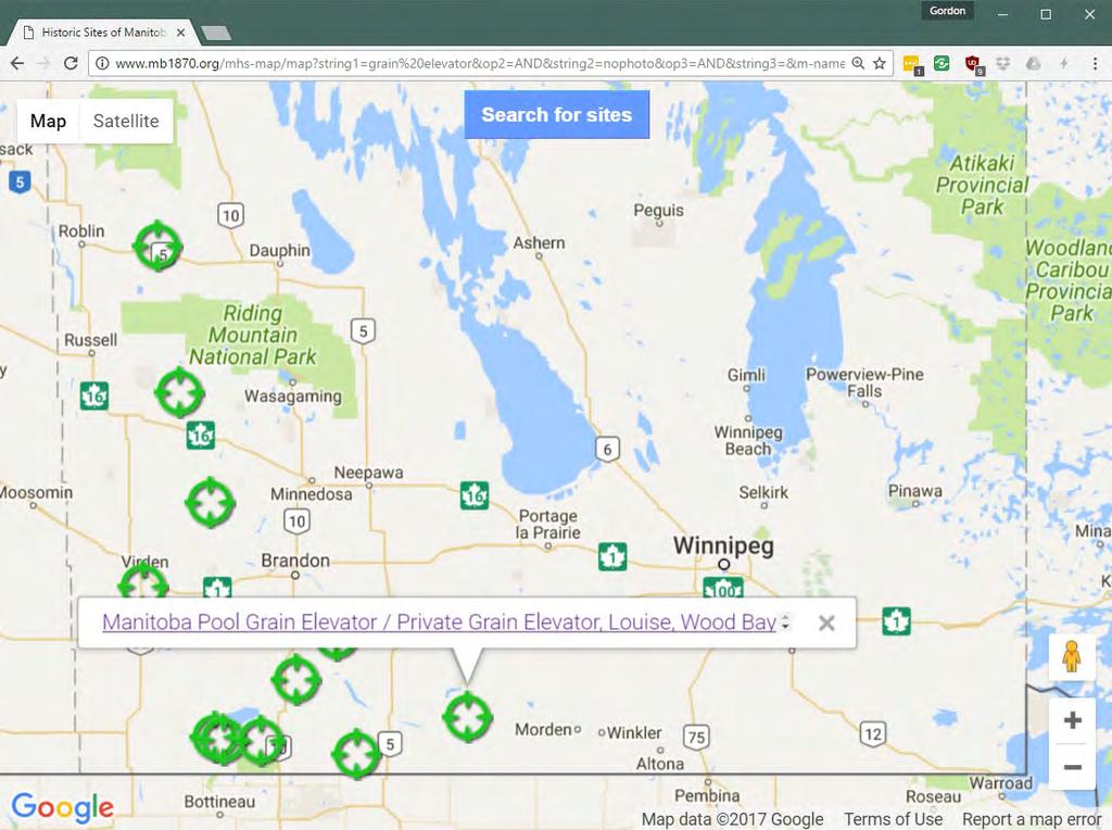
35
36 Some map themes Rural depopulation Agricultural mechanization Development of telecommunication and electrical infrastructure Changes in construction methods Evolution of educational system Changing attitudes to organized religion and institutions Home-front involvement in wartime
37 EDUCATION Map uses Historical and genealogical research Scouting for potential movie locations Finding cemeteries where loved ones are buried Teachers can lead their students on tours of faraway communities Students can identify new sites and do research on them (e.g., cenotaphs)
38 HERITAGE TOURISM Map uses Sites get more exposure than by accidental discovery Visitors can plan trips in advance Helps visitors to find obscure sites Provides expanded / updated information beyond what is provided at site GPS-enabled (& driverless) vehicles give historical information along travel route
39 Map uses ADVOCACY AND PUBLIC DESIGNATION Many sites warrant official designation, repair and protection Inclusion on the map may provide local leverage in the face of raised public awareness
40 Democratization of site designation Everyone helps to develop comprehensive inventory of historic sites for benefit of all Everything is made publicly, freely available Everyone is acknowledged Mistakes are corrected as found and new information is added as it becomes available Standard protocol ensures consistency and accuracy

41

42 Grain elevator countdown surviving wooden elevators: 51% in use 32% abandoned 17% unknown status
43 Provincially designated sites s 1950s 1960s 1970s 1980s 1990s 2000s 2010s
44 Rural municipally designated sites s 1950s 1960s 1970s 1980s 1990s 2000s 2010s
45 Map uses RURAL HERITAGE PLANNING Inventory You cannot count it, manage it, or promote it unless you know about it Achieve critical mass by crowdsourcing The back story: who, what, when, where, why
46 Map uses RURAL HERITAGE PLANNING Management / Preservation Worldwide talent pool Acquiring statistics Monitoring site status and effect of policies ( many eyes make light work ) Identifying problems or opportunities for maintenance, adaptive reuse, etc. Gauging community priorities (abandonment is a public statement)
47 Map uses RURAL HERITAGE PLANNING Promotion Online inventory provides deeper experience, via links to online information (e.g., QR) Reach new audiences Engage public dialogue on heritage priorities
48 Our future plans Continue mapping of new sites Maintain and update existing site information as possible (importance of ongoing public dialogue) Improved (and mobile) map interface Expand metadata to improve searchability of site inventory

49 Contact me Gordon Goldsborough
Your web browser (Safari 7) is out of date. For more security, comfort and. the best experience on this site: Update your browser Ignore
 is out of date. For more security, comfort and. the best experience on this site: Update your browser Ignore") Your web browser (Safari 7) is out of date. For more security, comfort and Activityengage the best experience on this site: Update your browser Ignore Introduction to GIS What is a geographic information
Your web browser (Safari 7) is out of date. For more security, comfort and Activityengage the best experience on this site: Update your browser Ignore Introduction to GIS What is a geographic information
Title: Storm of the Century: Documenting the 1993 Superstorm
 A. PAIIF 2011 Cover Page Title: Storm of the Century: Documenting the 1993 Superstorm Point of Contact: Name: Alex Granger Email: alex.granger@noaa.gov Phone Number: 571-555-9278 Mailing Address: Research
BUILDING AN ASSET MANAGEMENT GEODATABASE FOR RANCHING. Matt Crawford, GISP
 BUILDING AN ASSET MANAGEMENT GEODATABASE FOR RANCHING Matt Crawford, GISP Introduction East Foundation Formed in 2007 Mission Research Education Outreach Properties Six ranches ~ 215,000 acres San Antonio
The maps in this resource can be freely modified and reproduced in the classroom only.
 Teacher's Notes In this activity, students work collaboratively to explore sections of old and new maps. By closely examining these documents, students learn to see maps as more than just tools for locating
A Map Through Time Virtual Historic Cities
 A Map Through Time Virtual Historic Cities NEW WAYS OF EXPLORING DIGITAL COLLECTIONS FLORIDA INTERNATIONAL UNIVERSITY JAMIE ROGERS Coral Gables Virtual Historic City & Unearthing St. Augustine s Colonial
Exploring GIS Potential for Northwestern Ontario Land Information Ontario
 Exploring GIS Potential for Northwestern Ontario Land Information Ontario May 13, 2015 The LIO Vision LIO Vision: That all geographic information about Ontario is fully integrated and accessible LIO Goal:
Mapping Maine s Working Waterfront: for Our Heritage and Economy
 Mapping Maine s Working Waterfront: for Our Heritage and Economy Abstract Mapping Maine s Working Waterfronts is a collaborative project led by the Island Institute that inventories the state s current
Data-Sharing Agreement
 Data-Sharing Agreement Contributions to LandMark: The Global Platform of Indigenous and Community Lands This Data-Sharing Agreement provides the standards for contributing data to the LandMark: The Global
Looking at Communities: Comparing Urban and Rural Neighborhoods
 Looking at Communities: Comparing Urban and Rural Neighborhoods OVERVIEW & OBJECTIVES Our urban areas have become so dominant that frequently the children we teach have no connection with and very few
UTAH S STATEWIDE GEOGRAPHIC INFORMATION DATABASE
 UTAH S STATEWIDE GEOGRAPHIC INFORMATION DATABASE Data Information and Knowledge Management NASCIO Awards 2009 STATE GEOGRAPHIC INFORMATION DATABASE B. EXECUTIVE SUMMARY Utah has developed one of the most
MUNICIPALITY OF ANCHORAGE PUBLIC TRANSPORTATION DEPARTMENT AnchorRIDES TRANSPORTATION SYSTEM
 Purpose: The Public Transportation Department and contracted provider will provide safe transportation for AnchorRIDES customers and employees during severe weather or emergency conditions. AnchorRIDES
Development of the Portal of Cultural Heritage Objects the Kingdom of Poland
 Evgeny KOVALEV, Natalia KOVALEVA Sholokhov Moscow State University for the Humanities, Russia Hadi SALEH Vladimir State University Named After Alexander and Nikolay Stoletovs, Russia Development of the
Community Engagement in Cultural Routes SiTI Higher Institute on Territorial Systems for Innovation Sara Levi Sacerdotti
 Transnational Workshop Wroclaw, 7th-8th December 2016 Community Engagement in Cultural Routes SiTI Higher Institute on Territorial Systems for Innovation Sara Levi Sacerdotti levi@siti.polito.it TAKING
USER PARTICIPATION IN HOUSING REGENERATION PROJECTS
 USER PARTICIPATION IN HOUSING REGENERATION PROJECTS Dr. Hatice Sadıkoğlu Bahçeşehir University, Faculty of Architecture and Design Prof. Dr. Ahsen Özsoy Istanbul Technical University, Faculty of Architecture
Unit 1, Lesson 2. What is geographic inquiry?
 What is geographic inquiry? Unit 1, Lesson 2 Understanding the way in which social scientists investigate problems will help you conduct your own investigations about problems or issues facing your community
Rural Louisiana. A quarterly publication of the Louisiana Tech Rural Development Center
 Rural Louisiana A quarterly publication of the Louisiana Tech Rural Development Center Volume 4, No. 1, Fall 2009 Editor: Aaron K. Lusby Director, Asst. Professor Newsletter design: Stephanie Tidwell Student
REQUEST FOR PROPOSALS
 GRANDE CACHE REGIONAL DINOSAUR TRACKS FOUNDATION REQUEST FOR PROPOSALS Grande Cache Regional Dinosaur Tracks Feasibility Study Box 300 Grande Cache, AB. T0E 0Y0 INTRODUCTION AND SUMMARY The ( Foundation
STATE GEOGRAPHIC INFORMATION DATABASE
 STATE GEOGRAPHIC INFORMATION DATABASE Data Information and Knowledge Management STATE GEOGRAPHIC INFORMATION DATABASE EXECUTIVE SUMMARY Utah has developed one of the most comprehensive statewide GIS resources
Developing a Community Geographical Information System (GIS) in Rural India
 in Rural India") Developing a Community Geographical Information System (GIS) in Rural India Before rushing off and describing the unique challenges of developing a small scale GIS system India I better first describe
Developing a Community Geographical Information System (GIS) in Rural India Before rushing off and describing the unique challenges of developing a small scale GIS system India I better first describe
Zip Code Atlas: The United States Mail Business Bible (United States Zip Code Atlas) By American Map Corporation READ ONLINE
 By American Map Corporation READ ONLINE") Zip Code Atlas: The United States Mail Business Bible (United States Zip Code Atlas) By American Map Corporation READ ONLINE If you are searched for the ebook Zip Code Atlas: The United States Mail Business
Zip Code Atlas: The United States Mail Business Bible (United States Zip Code Atlas) By American Map Corporation READ ONLINE If you are searched for the ebook Zip Code Atlas: The United States Mail Business
INTERNATIONAL CULTURAL TOURISM CHARTER Managing Tourism at Places of Heritage Significance (1999)
") INTERNATIONAL CULTURAL TOURISM CHARTER Managing Tourism at Places of Heritage Significance (1999) Adopted by ICOMOS at the 12th General Assembly in Mexico, October 1999. INTRODUCTION The Charter Ethos
INTERNATIONAL CULTURAL TOURISM CHARTER Managing Tourism at Places of Heritage Significance (1999) Adopted by ICOMOS at the 12th General Assembly in Mexico, October 1999. INTRODUCTION The Charter Ethos
Frequently Asked Questions
 What is the Regional Transit Engagement Series? As one of the fastest growing regions in the country, there is recognition that long-term transit planning efforts should be accelerated if we are to remain
PUBLIC SAFETY POWER SHUTOFF POLICIES AND PROCEDURES
 PACIFIC GAS AND ELECTRIC COMPANY PUBLIC SAFETY POWER SHUTOFF POLICIES AND PROCEDURES SEPTEMBER 2018 1 PACIFIC GAS AND ELECTRIC COMPANY PUBLIC SAFETY POWER SHUTOFF POLICIES AND PROCEDURES SEPTEMBER 2018
1. Which agency in your state is PRIMARILY responsible for archiving geospatial data and managing archived geo records? (choose one) nmlkj.
 nmlkj.") Survey Intro Kentucky, North Carolina, and Utah are partnering with the Library of Congress as part of the National Digital Information Infrastructure and Preservation Program (NDIIPP) to examine the current
Survey Intro Kentucky, North Carolina, and Utah are partnering with the Library of Congress as part of the National Digital Information Infrastructure and Preservation Program (NDIIPP) to examine the current
Augusta Canal National Heritage Area 8 Grade Lesson Plans. Stage 1 Desired Results
 Title: Falling into Place Stage 1 Desired Results Subject/Course: Grade: 8th Instructional Time: 10 hrs. Big Ideas: Geographic Regions, The Fall Line and Early Settlements, Rivers and Water Power, The
It is clearly necessary to introduce some of the difficulties of defining rural and
 UNIT 2 CHANGING HUMAN ENVIRONMENTS G2 Theme 2 Investigating Settlement Change in MEDCs 2.1 What are the distinctive features of settlements? It is clearly necessary to introduce some of the difficulties
5 THEMES OF GEOGRAPHY ACTIVITIES/BOOKLET
 5 THEMES OF GEOGRAPHY ACTIVITIES/BOOKLET Choose two activites from each theme to complete LOCATION: 1) Using latitude and longitude lines on a world map, locate and note the following: the highest mountain
Utilizing GIS as a Critical Campus. Karen Jordan February 24, 2011
 Utilizing GIS as a Critical Campus Resource Karen Jordan February 24, 2011 Agenda Campus Background Opportunity for a Campus-wide GIS Data Structure and Collection How Has GIS Been Utilized on Campus Over
Economic Activity Economic A ctivity
 5 Economic Economic Activity Activity ECONOMIC ACTIVITY 5.1 EMPLOYMENT... 5-7 5.1.1 OBJECTIVE... 5-7 5.1.2 POLICIES... 5-7 5.2 PROTECTING THE AREA OF EMPLOYMENT... 5-9 5.2.1 OBJECTIVE... 5-9 5.2.2 POLICIES...
STAG LANE JUNIOR SCHOOL GEOGRAPHY POLICY
 Status-Recommended Prepared by: Megha Visavadia Date written January 2017 Shared with staff: Spring 2017 STAG LANE JUNIOR SCHOOL GEOGRAPHY POLICY Shared with governors: Spring 2018 Date for review: July
Declaration Population and culture
 Declaration Population and culture The ministers of the parties to the Alpine Convention regard the socio-economic and socio-cultural aspects mentioned in Article 2, Paragraph 2, Item a., as being central
TOWN OF GRAND FALLS WINDSOR
 TOWN OF GRAND FALLS WINDSOR DEPARTMENT OF ENGINEERING AND WORKS FREQUENTLY ASKED QUESTIONS FOR WINTER OPERATIONS... What streets are the first to be plowed & salted/sanded? The roads crews are each assigned
Topographic Strategy National Topographic Office March 2015
 www.linz.govt.nz Topographic Strategy National Topographic Office March 2015 >> Foreword Topographic information is vital to understanding our country and its assets, and for supporting economic development.
GIS Monroe Geographic Information System March 14, 2018
 GIS Monroe Geographic Information System March 14, 2018 Goals Maintain Enterprise/County-wide geo-database Increase spatial accuracy of data Build and acquire more data layers Increase use of GIS; as another
Touring Around the Islands of Atlantic Canada
 Lesson Overview Touring Around the Islands of Atlantic Canada In this lesson, students will examine the history and heritage of the islands of Atlantic Canada and examine their similarities and differences.
Getting Started with Community Maps
 Esri International User Conference San Diego, California Technical Workshops July 24, 2012 Getting Started with Community Maps Shane Matthews and Tamara Yoder Topics for this Session ArcGIS is a complete
Large Scale Mapping Policy for the Province of Nova Scotia
 Large Scale Mapping Policy for the Province of Nova Scotia December, 2005 Version 1.0 TABLE OF CONTENTS PAGE BACKGROUND...3 POLICY...5 Policy 1.0 Large Scale Mapping Program...5 Policy 2.0 Service Offering...5
SUPPORTS SUSTAINABLE GROWTH
 DDSS BBUUN NDDLLEE G E O S P AT I A L G O V E R N A N C E P A C K A G E SUPPORTS SUSTAINABLE GROWTH www.digitalglobe.com BRISBANE, AUSTRALIA WORLDVIEW-3 30 CM International Civil Government Programs US
K- 5 Academic Standards in. Social Studies. June 2013
 K- 5 Academic s in Social Studies June 203 Word Tables of s ONLY This Word version of the 2.7.2 social studies standards (DRAFT for Rulemaking 2.7.2) document contains the standards ONLY; no explanatory
Data-Sharing Agreement
 Data-Sharing Agreement Contributions to LandMark: The Global Platform of Indigenous and Community Lands This Data-Sharing Agreement provides the standards for contributing data to the LandMark: The Global
GIS and the Tourism Industry
 GIS and the Tourism Industry Dan Ake GIS Specialist SEDA - Council of Governments 201 Furnace Rd Lewisburg, PA 17837 www.seda-cog.org What are we going to talk about? The tourism industry GIS use in the
CLAREMONT MASTER PLAN 2017: LAND USE COMMUNITY INPUT
 Planning and Development Department 14 North Street Claremont, New Hampshire 03743 Ph: (603) 542-7008 Fax: (603) 542-7033 Email: cityplanner@claremontnh.com www.claremontnh.com CLAREMONT MASTER PLAN 2017:
Esri and GIS Education
 Esri and GIS Education Organizations Esri Users 1,200 National Government Agencies 11,500 States & Regional Agencies 30,800 Cities & Local Governments 32,000 Businesses 8,500 Utilities 12,600 NGOs 11,000
Framework on reducing diffuse pollution from agriculture perspectives from catchment managers
 Framework on reducing diffuse pollution from agriculture perspectives from catchment managers Photo: River Eden catchment, Sim Reaney, Durham University Introduction This framework has arisen from a series
WELCOME & INTRODUCTIONS
 GIS Monroe Geographic Information System January 31, 2018 WELCOME & INTRODUCTIONS Chip Thomas, Ritter GIS Sarah Schrader, Acct. Mgr., ESRI Chris Beyett, Solutions Engineer, ESRI Colleen Hinzmann, IT Director,
CHINESE GEOTOURISM AND GEOPARKS: SELECTED CASES
 CHINESE GEOTOURISM AND GEOPARKS: SELECTED CASES Global Eco Asia-Pacific Tourism Conference 2017, Adelaide 27-29 November, 2017 Dr Young Ng MH Geotourism Standing Committee, Geological Society of Australia
City of Madison Flooding Event AUGUST 20 TH, 2018-PRESENT
 City of Madison Flooding Event AUGUST 20 TH, 2018-PRESENT Presentation Overview Review of Flash Flooding and Flooding from High Lake Levels (August 20 th -Present) Lake Level Information Damages FEMA How
Saskatchewan s Early Trade Routes: The Impact of Geography on Trade
 Saskatchewan s Early Trade Routes: The Impact of Geography on Trade Lesson Overview In this lesson, students will compare and contrast prehistoric First Nations trade routes and trade goods with the routes
STUDY ON SPATIAL CULTURAL HERITAGE INTEGRATED INTO THE CORE CURRICULUM
 STUDY ON SPATIAL CULTURAL HERITAGE INTEGRATED INTO THE CORE CURRICULUM Wen-Huay Hsu a *,Yu-Peng Lai b a Dept. of Construction and Spatial Design, Tungnan University, No.152, Section 3, Beishen Rd., Shenkeng
GIS Resources for Local Governments
 ISSUE PAPER SERIES GIS Resources for Local Governments February 2018 NEW YORK STATE TUG HILL COMMISSION DULLES STATE OFFICE BUILDING 317 WASHINGTON STREET WATERTOWN, NY 13601 (315) 785-2380 WWW.TUGHILL.ORG
Think Global, Map Local! Introducing the. Open Green Map
 Think Global, Map Local! Introducing the Open Green Map Green Map System: Promoting inclusive participation in sustainable community development since 1995 Engaging over 550 communities in 54 countries,
THE SKY IN YOUR HANDS: TAKING ASTRONOMY TO VISUALLY IMPAIRED STUDENTS
 THE SKY IN YOUR HANDS: TAKING ASTRONOMY TO VISUALLY IMPAIRED STUDENTS The sky in your hands is a project created in 2009, during the International Year of Astronomy, with the goal to create an image of
Realizing benefits of Spatial Data Infrastructure A user s perspective from Environment Agency - Abu Dhabi
 Realizing benefits of Spatial Data Infrastructure A user s perspective from Environment Agency - Abu Dhabi Anil Kumar Director, Environment Information Management 26 April 2012 Geospatial World Forum,
Initial Borehole Drilling and Testing in Central Huron,
 JULY 2016 PRELIMINARY ASSESSMENT OF POTENTIAL SUITABILITY Initial Borehole Drilling and Testing in Central Huron, Huron-Kinloss and South Bruce DRAFT FOR DISCUSSION WITH COMMUNITIES In 2012, at the request
Progress Report. Flood Hazard Mapping in Thailand
 Progress Report Flood Hazard Mapping in Thailand Prepared By: Mr. PAITOON NAKTAE Chief of Safety Standard sub-beuro Disaster Prevention beuro Department of Disaster Prevention and Mitigation THAILAND E-mail:
EXCEPTIONAL CLOSURES - CHECKLIST FOR GOOSTREY COMMUNITY PRIMARY SCHOOL
 EXCEPTIONAL CLOSURES - CHECKLIST FOR GOOSTREY COMMUNITY PRIMARY SCHOOL To be reviewed Spring 2018 It is the policy of Goostrey Community Primary School to remain open unless we are forced to close because
Google Maps and Beyond
 Google Maps and Beyond Aaron Paul First American Title apaul@firstam.com 2015 APRA Symposium Association of Professional Reserve Analysts May 2 nd, 2015 Google Maps and Beyond - Overview Business case
Capturing and recording spatial data Guidelines, standards and best practices
 Capturing and recording spatial data Guidelines, standards and best practices February 2018 Established by Technical Note Author David Taylor, Data4FI, insight2impact About insight2impact Insight2impact
A Natural History of our Local Park: Geology and Ecological Succession
 Overview This lesson provides an opportunity for students to apply foundational ecological and geological concepts to investigate the natural history of their own local environment. Using field investigation
Working with ArcGIS Online
 Esri International User Conference San Diego, CA Technical Workshops July 12, 2011 Working with ArcGIS Online Bern Szukalski, Deane Kensok Topics for this Session ArcGIS Online Overview ArcGIS Online Content
National planning report for Denmark
 National planning report for Denmark from the Minister for Environment and Energy Local identity and new challenges Summary 2000 1 CONTENTS 4 PREFACE: REGIONAL DEVELOPMENT AND SPATIAL PLANNING 6 1. BALANCED
 Boone County GIS has the right to inquire about and investigate the use of any requested products and deny access to anyone based on concerns relating to privacy, security, public health, public safety,
MUNICIPALITY OF ANCHORAGE PUBLIC TRANSPORTATION DEPARTMENT AnchorRIDES PARATRANSIT SYSTEM
 Purpose: The Public Transportation Department (PTD) and AnchorRIDES paratransit contractor will provide transportation in as safe a manner as effectively possible. Paratransit vehicles primarily operate
Council Workshop on Neighbourhoods Thursday, October 4 th, :00 to 4:00 p.m. Burlington Performing Arts Centre
 Council Workshop on Neighbourhoods Thursday, October 4 th, 2012 1:00 to 4:00 p.m. Burlington Performing Arts Centre Agenda Introductions Warm-Up Exercise Presentation Exercise Neighbourhood Planning Break
Geography for the 2020 Round of Census
 Boundaries Key Census Data EA Id Population Male Female EA Id Area EA Id Num HH Avg HH size Geography for the 2020 Round of Census Linda Peters, Esri lpeters@esri.com Integration of Statistical and Geospatial
Getting On the Same Page and Parcel
 Getting On the Same Page and Parcel Local flair is a valued and cherished quality of small Vermont towns and cities. The Agency of Natural Resources works daily with town officials and local committee
Evaluating e-government : implementing GIS services in Municipality
 Evaluating e-government : implementing GIS services in Municipality Municipality of Thessaloniki - G.I.S. Unit Misirloglou Symeon Head of the GIS Unit ESRI UC - 2016 The GIS Section - subset of the department
GIS AND REMOTE SENSING FOR OPEN SPACE PROTECTION ENVIRONMENTAL MANAGEMENT DEPARTMENT
 GIS AND REMOTE SENSING FOR OPEN SPACE PROTECTION ENVIRONMENTAL MANAGEMENT DEPARTMENT 22 nd May 2009 1 Introduction It is said that more than 80% of the City s activities throughout the world are spatially
Economic and Social Council 2 July 2015
 ADVANCE UNEDITED VERSION UNITED NATIONS E/C.20/2015/11/Add.1 Economic and Social Council 2 July 2015 Committee of Experts on Global Geospatial Information Management Fifth session New York, 5-7 August
HURRICANE PREPAREDNESS GUIDE
 HURRICANE PREPAREDNESS GUIDE BE PREPARED! TABLE OF CONTENTS Basic Preparedness Tips... 3 Preparing Your Home... 4 What To Do... 5 Make a Hurricane Plan... 6 Important Information... 7 pacu.com 800.433.7228
Table G - 6. Mitigation Actions Identified for Implementation by the City of Kent ( ) (From Wilkin County Master Mitigation Action Chart)
 (From Wilkin County Master Mitigation Action Chart)") Table G - 6. Actions Identified by the () (From Master Action Chart) Multi-Hazard Plan, 2017 Action Comments 5 All-Hazards Local Planning & Regulations Update the Operations Plan on an annual basis. Work
Table G - 6. Actions Identified by the () (From Master Action Chart) Multi-Hazard Plan, 2017 Action Comments 5 All-Hazards Local Planning & Regulations Update the Operations Plan on an annual basis. Work
Tourism. April State Planning Policy state interest guideline. Department of Infrastructure, Local Government and Planning
 Department of Infrastructure, Local Government and Planning State Planning Policy state interest guideline Tourism April 2016 Great state. Great opportunity. Preface Using this state interest guideline
Understanding China Census Data with GIS By Shuming Bao and Susan Haynie China Data Center, University of Michigan
 Understanding China Census Data with GIS By Shuming Bao and Susan Haynie China Data Center, University of Michigan The Census data for China provides comprehensive demographic and business information
GIS and Governing Anchorage. GIS Critical for Efficient, Transparent Government How is GIS Program Doing Where can GIS Program Take us
 GIS and Governing Anchorage GIS Critical for Efficient, Transparent Government How is GIS Program Doing Where can GIS Program Take us Municipality of Anchorage Office of Economic And Community Development
The Use of Geographic Information Systems (GIS) by Local Governments. Giving municipal decision-makers the power to make better decisions
 by Local Governments. Giving municipal decision-makers the power to make better decisions") The Use of Geographic Information Systems (GIS) by Local Governments Giving municipal decision-makers the power to make better decisions Case Study: Examples of GIS Usage by Local Governments in North
The Use of Geographic Information Systems (GIS) by Local Governments Giving municipal decision-makers the power to make better decisions Case Study: Examples of GIS Usage by Local Governments in North
Community and Infrastructure Services Committee
 REPORT TO: DATE OF MEETING: November 7, 2016 Community and Infrastructure Services Committee SUBMITTED BY: Cynthia Fletcher, Interim Executive Director INS 519-741- PREPARED BY: WARD(S) INVOLVED: 2600
Keeping well and healthy when it is really cold
 Cold Weather Plan for England 2012 Keeping well and healthy when it is really cold Easy Read version of: Cold Weather Plan for England 2012: Protecting health and reducing harm from severe cold. What
Social Studies: Grade 4. Table of Contents
 Social Studies: Grade 4 Table of Contents Heritage and Citizenship Medieval Times Overview --------------------------- Page 1 Overall Expectations --------------------------- Page 1 Specific Expectations
Systems (GIS) - with a focus on.
 - with a focus on.") Introduction to Geographic Information Systems (GIS) - with a focus on localizing the MDGs Carmelle J. Terborgh, Ph.D. ESRI www.esri.com Flying Blind Jul 24th 2003 The Economist We Live in Two Worlds Natural
Introduction to Geographic Information Systems (GIS) - with a focus on localizing the MDGs Carmelle J. Terborgh, Ph.D. ESRI www.esri.com Flying Blind Jul 24th 2003 The Economist We Live in Two Worlds Natural
The Blacktown Fishing Bat
 Factors That Shape Places The Blacktown Fishing Bat As urban Sydney sprawls in all directions, the Blacktown Local Government Area is changing dramatically. This Geographical Inquiry will focus on the
3/4/2010. ESRI Education Community. CommunityWeb Mapping Tools
 Sketch-A-Map Reading, Writing and Math from a Different Perspective Education Community at ESRI Web Mapping Tools ESRI Education Community http://edcommunity.esri.com CommunityWeb Mapping Tools http://edcommunity.esri.com/maps/index.cfm
Introduction to Google Mapping Tools
 Introduction to Google Mapping Tools Google s Mapping Tools Explore geographic data. Organize your own geographic data. Visualize complex data. Share your data with the world. Tell your story and educate
Challenges and Potentials of Place Based Information Management in Nepal"
 Nineteenth United Nations Regional Cartographic Conference for Asia and the Pacific, Bangkok, Thailand, 29 October 1 November 2012 Challenges and Potentials of Place Based Information Management in Nepal"
Social Studies Grade 2 - Building a Society
 Social Studies Grade 2 - Building a Society Description The second grade curriculum provides students with a broad view of the political units around them, specifically their town, state, and country.
ESRI NONPROFIT/CONSERVATION GRANTS PROGRAM STATUS REPORT JANUARY 2010
 ESRI NONPROFIT/CONSERVATION GRANTS PROGRAM STATUS REPORT JANUARY 2010 Grantee ESRI Client Number 150983 FARMINGTON RIVER WATERSHED ASSOCIATION 749 Hopmeadow Street, Simsbury, Connecticut 06070 Contact:
COMMUNITY SERVICE AREA
 INSTITUTE FOR TRIBAL ENVIRONMENTAL PROFESSIONALS Tribal Waste and Response Assistance Program (TWRAP) Developing and Implementing a Tribal Integrated Solid Waste Management Plan April 12-14, 2016 Palm
Level 1 Geography, 2017
 91007 910070 1SUPERVISOR S Level 1 Geography, 2017 91007 Demonstrate geographic understanding of environments that have been shaped by extreme natural event(s) 9.30 a.m. Thursday 23 November 2017 Credits:
GIS Workshop Data Collection Techniques
 GIS Workshop Data Collection Techniques NOFNEC Conference 2016 Presented by: Matawa First Nations Management Jennifer Duncan and Charlene Wagenaar, Geomatics Technicians, Four Rivers Department QA #: FRG
Factors Affecting Human Settlement
 Factors Affecting Human Settlement Physical Factors One of the most basic factors affecting settlement patterns is the physical geography of the land. Climate is key, because if a place is too dry, too
Information. Information Technology. Geographic. Services (GIS) 119 W Indiana Ave Deland, FL 32720
 119 W Indiana Ave Deland, FL 32720") Information Technology Geographic Information Services (GIS) 119 W Indiana Ave Deland, FL 32720 A GIS consists of 5 primary components: Hardware Software People Data Methods or Business Processes --- Hardware
Information Technology Geographic Information Services (GIS) 119 W Indiana Ave Deland, FL 32720 A GIS consists of 5 primary components: Hardware Software People Data Methods or Business Processes --- Hardware
SPONSORSHIP GOLD SILVER BRONZE WHAT? WHEN? WHERE? HOW MUCH?
 SPONSORSHIP WHAT? P u r p l e D a y 2 0 1 8 i s a s e r i e s o f c o m m u n i t y e v e n t s c o o r d i n a t e d b y a n a r m y o f v o l u n t e e r s a n d f u n d r a i s e r s n a t i o n a l
H O W T O G U I D E. Sidewalks, Chalkboards, Apps...We Can All..#ChalkAboutLove
 H O W T O G U I D E Sidewalks, Chalkboards, Apps...We Can All..#ChalkAboutLove ONE month Feb 1 - Feb 28, 2018 14 years 2005 Marked the 1st official year of Teen DV Awareness Teen Dating Violence Awareness
Technical Memorandum #2 Future Conditions
 Technical Memorandum #2 Future Conditions To: Dan Farnsworth Transportation Planner Fargo-Moorhead Metro Council of Governments From: Rick Gunderson, PE Josh Hinds PE, PTOE Houston Engineering, Inc. Subject:
Geographic Skill 5: Answering Geographic Questions 1. Develop and present combinations of geographic information to answer geographic questions.
 hen Prime Minister John A. Macdonald insisted in BY NI CK A L K ER Lesson overview To celebrate Canada s 150th Birthday, have students research something truly unique to Canada. This can be anything from
MEADOWS PRIMARY SCHOOL and NURSERY GEOGRAPHY POLICY
 MEADOWS PRIMARY SCHOOL and NURSERY GEOGRAPHY POLICY Purpose of study The teaching of Geography at Meadows is done by following the 2014 National Curriculum. The planning and teaching of the subject aims
Content. Teaching Cultural Tourism in General Education: A Module for Cultural Heritage Studies. What is Cultural Tourism?
 Teaching Cultural Tourism in General Education: A Module for Cultural Heritage Studies Presentation for the GE Conference 2012, City University of Hong Kong Dr. Michael W. H. Chan Department of General
INDIANA ACADEMIC STANDARDS FOR SOCIAL STUDIES, WORLD GEOGRAPHY. PAGE(S) WHERE TAUGHT (If submission is not a book, cite appropriate location(s))
 WHERE TAUGHT (If submission is not a book, cite appropriate location(s))") Prentice Hall: The Cultural Landscape, An Introduction to Human Geography 2002 Indiana Academic Standards for Social Studies, World Geography (Grades 9-12) STANDARD 1: THE WORLD IN SPATIAL TERMS Students
Prentice Hall: The Cultural Landscape, An Introduction to Human Geography 2002 Indiana Academic Standards for Social Studies, World Geography (Grades 9-12) STANDARD 1: THE WORLD IN SPATIAL TERMS Students
CLLD Cooperation OFFER
 Title of the proposed project (English) CLLD Cooperation OFFER PARKS PROTECTION III - Management, Protection and Economic Development in Protected Areas Type of project (select as many as you want) Cooperation
Economic and Social Council
 United Nations Economic and Social Council Distr.: General 23 May 2012 Original: English E/CONF.101/100 Tenth United Nations Conference on the Standardization of Geographical Names New York, 31 July 9
Tahlequah Public Schools Inclement Weather Transportation Plan
 Tahlequah Public Schools Inclement Weather Transportation Plan Inclement Weather with Ice and Snow From time to time throughout the school year, weather may force a change in the District s normal operating