Getting On the Same Page and Parcel
|
|
|
- Jesse Kennedy
- 6 years ago
- Views:
Transcription

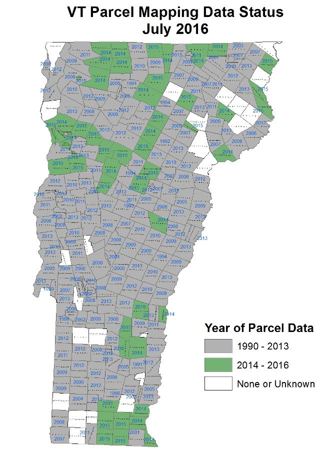
1 Getting On the Same Page and Parcel Local flair is a valued and cherished quality of small Vermont towns and cities. The Agency of Natural Resources works daily with town officials and local committee volunteers to provide the resources that allow towns to set conservation and environmental protection goals and actions that are specific to their town s land type and community voice. Yet there are some situations where every town could benefit from slightly forgoing its own style and getting on the same page. How towns create and update their parcel data across the state is one of those situations. All property boundaries, or land parcels, in a town should theoretically be documented and kept updated by each town. And though this mostly happens universally across Vermont s 255 towns, the format in which the parcel maps are produced varies drastically. Most towns have digital maps, yet some still use paper copies. Among the digital mappers, the data may be saved in different file types that don t make them comparable with other towns. Some data is from 1998 some is from 2015, and everywhere in between. In other words, looking at a map of all the parcel data in Vermont looks like a patchy quilt with tiny, inconvenient holes. Because the parcel data from each town varies in age, content, and availability, there are not only holes in the quilt the quilt squares are all mismatched and come from totally different color themes. Check out the status of Vermont s parcel mapping data on the final page. WHY IT MATTERS This lack of consistent parcel data is a huge problem for any researcher or organization that wants to evaluate project impacts, conduct feasibility studies, or create planning guides across multiple towns be it a region, a county, or the entire state. A conservation organization that wants to know how many individual properties border a river corridor to be conserved across multiple towns may need to visit each town to gather individual, updated data and work to merge the data together. This can exponentially increase the time it takes to complete a project if possible and places tough limits on information exchange and measured policy making. A huge inter-agency project is starting to change that by making sure that State and local governments have the same kind of parcel information for all properties in the State. Leslie Pelch is the Outreach Coordinator for Vermont Center for Geographic Information (VCGI), a division of State government charged with assisting digital mappers across Vermont and providing datasets to help them do their work. Leslie has been charged with doing outreach and teaching about this collaborative Statewide Parcel Mapping Project between state agencies and towns. To explain how important this project is to our land-use decision making, we spoke with Leslie Pelch.
2 ANR: Every town is doing their own thing when it comes to parcel mapping. Tell us more about the situation. PELCH: Exactly. Towns have different interests, different capacities, and different software. Which means that parcel mapping data across towns are in different uncompilable formats, or haven t been updated at the same frequency. For instance, a lot of towns have mappers that use CAD software instead of GIS, since ArcGIS is a more expensive software. CAD uses different filetypes than ArcGIS. Some towns got excited about the idea of using digital mapping technology, yet are still very weary of the computer. Depending on resources, the idea of digital mapping data may not easily be within reach. These towns still might have paper maps updated and use them, but do not translate the recent data into digital files. There are a small handful of towns that don t even have paper maps. Literally no maps. And some have very old maps that they keep drawing on in pencil to reflect updates to the parcels. There are few towns in this category, maybe 2 or 3 it s very limited. There is truly a full spectrum represented in the State. Each town makes its own decisions. It completely depends on the processes in that town, and the individual personalities in that town. ANR: Was there an era when digital mapping technology became popular and towns started digitizing their parcel data? When did the mass transition generally happen? PELCH: The first time the State recognized the value of having digital parcel data was in the early 1990 s. It was around the same time the State was looking at digital mapping data as a statewide resource as opposed to just locally-available, isolated data. So in the early 90 s, the State funded a digitization project. Pretty much any town that had a tax map could get it digitized. In that time, a lot of data was created but there was no follow-up to the program. It was just a one time deal, and a lot of that original data never got updated, even if the town continued to update their parcel maps in a non-digital format. You ll see a lot of towns that have digital parcel data that hasn t been updated since that era in the 90 s. That s over years ago now, in some cases. ANR: How is parcel data created in the first place? PELCH: Parcel boundary data is not created through land surveys. It can be, but generally, its an amalgamation of all sorts of pieces of information land records, property deeds, etc. There are consultants that specialize in digging through historic and recent town records and translating the information into parcel boundary data. From existing paper maps, a consultant may use additional records to enhance the accuracy of the parcel boundary, and convert the information into a digital format. Once a digital format is in place, the digitized parcel data can more easily be updated and maintained. ANR: So how did the idea start to take on a statewide project to standardize Vermont parcel data and bring all towns up to speed? PELCH: My current boss, John Adams, was working in the Agency of Commerce and Community Development three years ago, and wanted to do a statewide analysis for a particular project. He was fairly new at his job at the time, so when he started planning the analysis, he began hearing from people, No, you can t do that. You can t do a statewide analysis with the parcel data we have now.
3 John called me up at VCGI we were not part of the Agency at that time and said, What s up with this, Leslie?! Shouldn t I be able to do this? I said, I know! It s crazy. This was a little over three years ago. John said, Well, let s do a meeting and get people together and change this. I am thankful he suggested this and brought energy to the idea because I have to admit I was somewhat skeptical that there would be interest. As it turns out, there was a huge amount of interest at the level of State agencies and regional planning commissions to change things to do something about it. And here we are, almost three years into the project. ANR: You ve been doing outreach to Vermont towns about this. Any opposition to the idea? PELCH: Yes. There are a lot of towns that do not think that the map is necessary. It s not survey quality. It s bringing together a bunch of different pieces of information; it s imperfect. But that s the thing with parcel data. Even if you had high-quality land surveys for all the parcels in your town and put them together there would be gaps. At the parcel level, those gaps aren t significant. You can still do multi-town, regional, and statewide analyses from slightly imperfect data boundaries. But some towns are worried that there will now be a document that landowners, banks, realtors, and officials can look at and say, Oh, well, the line is there, and therefore They worry that it will be misused, misinterpreted, and that angry neighbors are going to start suing each other over the boundaries. One of our most important goals is to educate town officials and staff about what the data means, and how it can be used. We want to be going out there and saying, This is how you can use it. Here are the caveats. One gentleman raised his doubts at a public meeting about how the map seemed useless. He said, "It s useless because it s not accurate and you re admitting that there are flaws and mistakes. It s not survey quality, so therefore it s useless. It s not that it s useless. You just have to find the right scale to use it at. The disclaimer for this data is that it is only appropriate to be used at the planning level. However, towns can still uncover a lot of direct benefits from updating their parcel maps. For example the town of Woodford received funding to update its parcel maps a couple years ago. They compared the updated data the town s grand list, and found an 80-acre parcel of land that was not on grand list. The town officials went and talked to neighbors, who found the owner of the parcel, and he plainly explained that he had never been taxed before. Plain and simple. We re starting to see as towns start updating their parcel datasets, they re finding properties where acreage is off significantly. ANR: What are the new standards that towns are being supported to meet in this new project? PELCH: The standard itself focuses on the format of the parcel data layers and the kind of information attached to those data layers the attributes. Two minimum requirements are that the data exists that there is parcel data for the town and that it has been updated within the past two years.
4 On Format: The project leaders wanted the standard to be as friendly as possible. The standard says that both shapefiles (.shp) and file geodatabase (.gdb) are acceptable for parcel data crosscomparison. If a town can provide a file geodatabase, that s great we encourage that. But we don t really lose that much by receiving data as shapefiles, and it allows for software flexibility among towns. On Attribute Information: Each data layer each parcel has information associated with it. This is one of the most inconsistent things about parcel data right now, that makes it truly painstaking to combine and compare. The new data standard requires all parcel data units be attached the following information: TOWN NAME, YEAR, SPAN #, and LOCAL TAX ID #. The standard also requires the data layers to include what s called feature-level metadata, which captures information about who last authored or changed the data, and other information about when, why, and who created the data. There are also recommended naming conventions so that the parcel data attributes are comparable and consistent. The value of standardized attribute data to State agencies for folks who help plan construction projects and beyond is huge. It costs real time and money to visit town offices during their limited hours to match up local tax ID information with parcel data sets. This is largely what has driven the business decision to get this done: do a better job on our tasks, and be more efficient doing it. ANR: And be able to connect parcels to landowner information? PELCH: The key is that when this project is complete, there won t be critical information being maintained in two different places. Everyone will be able to use a definitive source which is the grand list provided by the town to connect landowner information to the parcel data. * * * How the data will impact natural resource planning and policies: Good data is critical for making sound decisions about how we use and manage lands, wildlife, and infrastructure. The parcel is a data unit that is so important to regional and statewide analyses regarding many natural resources issues, like keeping large forest blocks intact, river corridor planning, renewable energy siting, and so much more. The Agency of Natural Resources is one of the State agencies helping to fund and support the project so that staff can work more efficiently to fulfill public missions and to make data available to the public. Once complete, updated parcel data will be reflected on popular data and mapping applications like the Natural Resources Atlas. It will also be available for download via the Agency s OpenGIS portal, an environmental-subset of the VCGI Open Data Warehouse where it will also be available. To learn more about the Statewide Parcel Mapping Program and plans to keep parcels regularly updated after initial efforts, go to: or contact Leslie Pelch at (802)
5
Introduction and Project Overview
 Greater New Orleans Regional Land Use Modeling GIS Techniques in a P olitical C ontext Louisiana Remote Sensing and GIS Workshop Wednesday, April 24, 2013 Working Towards a Shared Regional Vision Introduction
GIS for the Beginner on a Budget
 GIS for the Beginner on a Budget Andre C. Bally, RLA, GIS Coordinator, Harris County Public Infrastructure Department Engineering Division This presentation, GIS for Beginners on a Budget. will briefly
VT STATEWIDE PROPERTY PARCEL MAPPING PROJECT & PROGRAM
 VT STATEWIDE PROPERTY PARCEL MAPPING PROJECT & PROGRAM BUILDING A FOUNDATIONAL MAPPING DATA LAYER Leslie Pelch, VCGI April 2017 WHAT ARE THE STATEWIDE PROPERTY PARCEL MAPPING PROJECT & PROGRAM? A project
Introducing GIS analysis
 1 Introducing GIS analysis GIS analysis lets you see patterns and relationships in your geographic data. The results of your analysis will give you insight into a place, help you focus your actions, or
GIS ADMINISTRATOR / WEB DEVELOPER EVANSVILLE-VANDERBURGH COUNTY AREA PLAN COMMISSION
 GIS ADMINISTRATOR / WEB DEVELOPER EVANSVILLE-VANDERBURGH COUNTY AREA PLAN COMMISSION SALARY RANGE INITIATION $43,277 SIX MONTHS $45,367 POSITION GRADE PAT VI The Evansville-Vanderburgh County Area Plan
Geodatabase 101 Why, What, & How
 Geodatabase 101 Why, What, & How Beau Dealy Dealy Geomatics, LC beau@dealygeo.com Curt Moore InfiniTec, Inc. cmoore@infinitec.net ... first, a brief explanation. Geodata traditionally stored as two components
A Regional Database Tracking Fire Footprint Each Year within the South Atlantic Region: Current Database Description and Future Directions
 A Regional Database Tracking Fire Footprint Each Year within the South Atlantic Region: Current Database Description and Future Directions Last Updated on September 30, 2018 Contributors: NatureServe,
Show Me the Money. >> By Robert L. Young, LS
 Show Me the Money here is a lot of talk about the role that GIS plays in business, and in society at large. I d like to talk about what GIS means to surveyors, at least to this surveyor: my experience
ASTRO 114 Lecture Okay. What we re going to discuss today are what we call radiation laws. We ve
 ASTRO 114 Lecture 15 1 Okay. What we re going to discuss today are what we call radiation laws. We ve been spending a lot of time talking about laws. We ve talked about gravitational laws, we ve talked
Quadratic Equations Part I
 Quadratic Equations Part I Before proceeding with this section we should note that the topic of solving quadratic equations will be covered in two sections. This is done for the benefit of those viewing
base 2 4 The EXPONENT tells you how many times to write the base as a factor. Evaluate the following expressions in standard notation.
 EXPONENTIALS Exponential is a number written with an exponent. The rules for exponents make computing with very large or very small numbers easier. Students will come across exponentials in geometric sequences
Linear Referencing in Boulder County, CO. Getting Started
 Linear Referencing in Boulder County, CO Getting Started 1 Authors Janie Pierre GIS Technician, Boulder County Road centerline and storm sewer geodatabases & maps John Mosher GIS Specialist, Boulder County
2011 Land Use/Land Cover Delineation. Meghan Jenkins, GIS Analyst, GISP Jennifer Kinzer, GIS Coordinator, GISP
 2011 Land Use/Land Cover Delineation Meghan Jenkins, GIS Analyst, GISP Jennifer Kinzer, GIS Coordinator, GISP History O Key Points O Based on Anderson s Land Use and Land Cover Classification System O
ASTRO 114 Lecture Okay. We re now gonna continue discussing and conclude discussing the entire
 ASTRO 114 Lecture 55 1 Okay. We re now gonna continue discussing and conclude discussing the entire universe. So today we re gonna learn about everything, everything that we know of. There s still a lot
The Use of Geographic Information Systems (GIS) by Local Governments. Giving municipal decision-makers the power to make better decisions
 by Local Governments. Giving municipal decision-makers the power to make better decisions") The Use of Geographic Information Systems (GIS) by Local Governments Giving municipal decision-makers the power to make better decisions Case Study: Examples of GIS Usage by Local Governments in North
The Use of Geographic Information Systems (GIS) by Local Governments Giving municipal decision-makers the power to make better decisions Case Study: Examples of GIS Usage by Local Governments in North
Preparing GIS Data for NG9-1-1 in the Commonwealth of Virginia
 Preparing GIS Data for NG9-1-1 in the Commonwealth of Virginia Brian Crumpler Regional Coordinator Virginia Information Technologies Agency (VITA) February 28, 2017 1 1 Overview: Sharing ways Virginia
Mapping Historical Information Using GIS
 Mapping Historical Information Using GIS David Yun, GISP Troy Lawson ABSTRACT The City of San Luis Obispo, California, is rich with history. It is one of California s oldest communities that began with
Developing a Community Geographical Information System (GIS) in Rural India
 in Rural India") Developing a Community Geographical Information System (GIS) in Rural India Before rushing off and describing the unique challenges of developing a small scale GIS system India I better first describe
Developing a Community Geographical Information System (GIS) in Rural India Before rushing off and describing the unique challenges of developing a small scale GIS system India I better first describe
Reminder that we update the website: with new information, project updates, etc.
 1 Reminder that we update the website: http://www.njfishandwildlife.com/ensp/connectivity_proj.htm with new information, project updates, etc. regularly. Any suggestions are welcome on how to make the
VCCS Geospatial Institute 2011
 John McGee Jennifer McKee With support from: NSF DUE-0903270 Acquiring and Downloading Digital Data in partnership with: Geospatial Technician Education Through Virginia s Community Colleges (GTEVCC) Review
Section 2. Indiana Geographic Information Council: Strategic Plan
 Section 2. Indiana Geographic Information Council: Strategic Plan Introduction A geographic information system (GIS) is an automated tool that allows the collection, modification, storage, analysis, and
The Indiana Data Sharing Initiative and the IndianaMap. Cross-Boundary Collaboration and Partnerships. State of Indiana
 The Indiana Data Sharing Initiative and the IndianaMap Cross-Boundary Collaboration and Partnerships State of Indiana Brian Arrowood, CIO James Sparks, GIO EXECUTIVE SUMMARY Under the collaboration oriented
Digital Tax Maps Westport Island Project Summary
 Digital Tax Maps Westport Island Project Summary Presented to the: Mid-Coast Regional Planning Commission Creating GIS-Based Digital Tax Maps And Linked Assessment Records For Small Towns on a Budget Dennis
Steve Pietersen Office Telephone No
 Steve Pietersen Steve.Pieterson@durban.gov.za Office Telephone No. 031 311 8655 Overview Why geography matters The power of GIS EWS GIS water stats EWS GIS sanitation stats How to build a GIS system EWS
STATE GEOGRAPHIC INFORMATION DATABASE
 STATE GEOGRAPHIC INFORMATION DATABASE Data Information and Knowledge Management STATE GEOGRAPHIC INFORMATION DATABASE EXECUTIVE SUMMARY Utah has developed one of the most comprehensive statewide GIS resources
Vector Analysis: Farm Land Suitability Analysis in Groton, MA
 Vector Analysis: Farm Land Suitability Analysis in Groton, MA Written by Adrienne Goldsberry, revised by Carolyn Talmadge 10/9/2018 Introduction In this assignment, you will help to identify potentially
Introduction to Computational Complexity
 Introduction to Computational Complexity Tandy Warnow October 30, 2018 CS 173, Introduction to Computational Complexity Tandy Warnow Overview Topics: Solving problems using oracles Proving the answer to
Road to GIS, PSE s past, present and future
 Road to GIS, PSE s past, present and future PSE Gas Mapping History 1840 Early 1900 s Gas piping was captured in Field Books which were than converted onto Mylar maps using Pen and Ink. 1955 Washington
Take the Anxiety Out of Word Problems
 Take the Anxiety Out of Word Problems I find that students fear any problem that has words in it. This does not have to be the case. In this chapter, we will practice a strategy for approaching word problems
GIS Monroe Geographic Information System March 14, 2018
 GIS Monroe Geographic Information System March 14, 2018 Goals Maintain Enterprise/County-wide geo-database Increase spatial accuracy of data Build and acquire more data layers Increase use of GIS; as another
Algebra. Here are a couple of warnings to my students who may be here to get a copy of what happened on a day that you missed.
 This document was written and copyrighted by Paul Dawkins. Use of this document and its online version is governed by the Terms and Conditions of Use located at. The online version of this document is
State GIS Officer/GIS Data
 State GIS Officer/GIS Data This Act creates the position of state Geographic Information Systems (GIS) officer. The Act: requires the state GIS officer to adopt or veto the GIS data standards and a statewide
Write a report (6-7 pages, double space) on some examples of Internet Applications. You can choose only ONE of the following application areas:
 on some examples of Internet Applications. You can choose only ONE of the following application areas:") UPR 6905 Internet GIS Homework 1 Yong Hong Guo September 9, 2008 Write a report (6-7 pages, double space) on some examples of Internet Applications. You can choose only ONE of the following application
UPR 6905 Internet GIS Homework 1 Yong Hong Guo September 9, 2008 Write a report (6-7 pages, double space) on some examples of Internet Applications. You can choose only ONE of the following application
Village Weather, Snow, Ice, Breakup, Flooding, Fire sites
 Village Weather, Snow, Ice, Breakup, Flooding, Fire sites What is the weather like now in Villages?... 1 BREAKUP:... 2 Flooding... 3 Fires... 5 Weather Predictability, Weather and Ice Advisories and How
Excerpt of Transcribed and Coded Content Data from Study 2 (Dialogue Study)
") Appendix 3 Excerpt of Transcribed and Coded Content Data from Study 2 (Dialogue Study) This excerpt is intended to provide and example of the transcribed and coded content data. The convention used to
Appendix 3 Excerpt of Transcribed and Coded Content Data from Study 2 (Dialogue Study) This excerpt is intended to provide and example of the transcribed and coded content data. The convention used to
The Dance Hall Goes in What School District?
 The Dance Hall Goes in What School District? Vern C. Svatos Jarrod S. Doucette Abstract This paper presents the results of a GIS mapping effort created for the Delaware State Department of Education using
Part I Electrostatics. 1: Charge and Coulomb s Law July 6, 2008
 Part I Electrostatics 1: Charge and Coulomb s Law July 6, 2008 1.1 What is Electric Charge? 1.1.1 History Before 1600CE, very little was known about electric properties of materials, or anything to do
Final Group Project Paper. Where Should I Move: The Big Apple or The Lone Star State
 Final Group Project Paper Where Should I Move: The Big Apple or The Lone Star State By: Nathan Binder, Shannon Scolforo, Kristina Conste, Madison Quinones Main Goal: Determine whether New York or Texas
1 Impact Evaluation: Randomized Controlled Trial (RCT)
") Introductory Applied Econometrics EEP/IAS 118 Fall 2013 Daley Kutzman Section #12 11-20-13 Warm-Up Consider the two panel data regressions below, where i indexes individuals and t indexes time in months:
Introductory Applied Econometrics EEP/IAS 118 Fall 2013 Daley Kutzman Section #12 11-20-13 Warm-Up Consider the two panel data regressions below, where i indexes individuals and t indexes time in months:
International Journal of Scientific & Engineering Research, Volume 6, Issue 11, November ISSN
 International Journal of Scientific & Engineering Research, Volume 6, Issue 11, November-2015 42 Geospatial Mapping of Fish Farms in Anambra State Using GIS Approach Ojiako, J.C., Okafor, C. M., Igbokwe,
 Boone County GIS has the right to inquire about and investigate the use of any requested products and deny access to anyone based on concerns relating to privacy, security, public health, public safety,
Mapping Maine s Working Waterfront: for Our Heritage and Economy
 Mapping Maine s Working Waterfront: for Our Heritage and Economy Abstract Mapping Maine s Working Waterfronts is a collaborative project led by the Island Institute that inventories the state s current
Descriptive Statistics (And a little bit on rounding and significant digits)
") Descriptive Statistics (And a little bit on rounding and significant digits) Now that we know what our data look like, we d like to be able to describe it numerically. In other words, how can we represent
Descriptive Statistics (And a little bit on rounding and significant digits) Now that we know what our data look like, we d like to be able to describe it numerically. In other words, how can we represent
GIS TECHNICIAN I GIS TECHNICIAN II
 GIS TECHNICIAN I GIS TECHNICIAN II CITY OF ROSEVILLE DEFINITION To perform a variety of technical office and field work duties related to the creation and maintenance of maps, tables, graphs and other
Nomination Form. Clearinghouse. New York State Office for Technology. Address: State Capitol-ESP, PO Box
 NASIRE 2001 RECOGNITION AWARDS Recognizing Outstanding Achievement in the Field of Innovative Use of Technology Nomination Form Title of Nomination: Manager/Job Title: Agency: NYS Geographic Information
Ratios, Proportions, Unit Conversions, and the Factor-Label Method
 Ratios, Proportions, Unit Conversions, and the Factor-Label Method Math 0, Littlefield I don t know why, but presentations about ratios and proportions are often confused and fragmented. The one in your
Geospatial natural disaster management
 Geospatial natural disaster management disasters happen. are you ready? Natural disasters can strike almost anywhere at any time, with no regard to a municipality s financial resources. These extraordinarily
Modern Physics notes Paul Fendley Lecture 1
 Modern Physics notes Paul Fendley fendley@virginia.edu Lecture 1 What is Modern Physics? Topics in this Class Books Their Authors Feynman 1.1 What is Modern Physics? This class is usually called modern
from Euclid to Einstein
 WorkBook 2. Space from Euclid to Einstein Roy McWeeny Professore Emerito di Chimica Teorica, Università di Pisa, Pisa (Italy) A Pari New Learning Publication Book 2 in the Series WorkBooks in Science (Last
Digitization in a Census
 Topics Connectivity of Geographic Data Sketch Maps Data Organization and Geodatabases Managing a Digitization Project Quality and Control Topology Metadata 1 Topics (continued) Interactive Selection Snapping
Line Integrals and Path Independence
 Line Integrals and Path Independence We get to talk about integrals that are the areas under a line in three (or more) dimensional space. These are called, strangely enough, line integrals. Figure 11.1
Moving from Keeping Stuff to Geoarchiving: Developing Dynamic Geospatial Data Archives
 Moving from Keeping Stuff to Geoarchiving: Developing Dynamic Geospatial Data Archives Alec Bethune- NC Center for Geographic Information and Analysis Kelly Eubank- North Carolina State Archives North
The Basics COPYRIGHTED MATERIAL. chapter. Algebra is a very logical way to solve
 chapter 1 The Basics Algebra is a very logical way to solve problems both theoretically and practically. You need to know a number of things. You already know arithmetic of whole numbers. You will review
UTAH S STATEWIDE GEOGRAPHIC INFORMATION DATABASE
 UTAH S STATEWIDE GEOGRAPHIC INFORMATION DATABASE Data Information and Knowledge Management NASCIO Awards 2009 STATE GEOGRAPHIC INFORMATION DATABASE B. EXECUTIVE SUMMARY Utah has developed one of the most
1. Which agency in your state is PRIMARILY responsible for archiving geospatial data and managing archived geo records? (choose one) nmlkj.
 nmlkj.") Survey Intro Kentucky, North Carolina, and Utah are partnering with the Library of Congress as part of the National Digital Information Infrastructure and Preservation Program (NDIIPP) to examine the current
Survey Intro Kentucky, North Carolina, and Utah are partnering with the Library of Congress as part of the National Digital Information Infrastructure and Preservation Program (NDIIPP) to examine the current
GIS Lecture 4: Data. GIS Tutorial, Third Edition GIS 1
 GIS Lecture 4: Data GIS 1 Outline Data Types, Tables, and Formats Geodatabase Tabular Joins Spatial Joins Field Calculator ArcCatalog Functions GIS 2 Data Types, Tables, Formats GIS 3 Directly Loadable
Geography for the 2020 Round of Census
 Boundaries Key Census Data EA Id Population Male Female EA Id Area EA Id Num HH Avg HH size Geography for the 2020 Round of Census Linda Peters, Esri lpeters@esri.com Integration of Statistical and Geospatial
MODERNIZATION OF THE MUNICIPAL MAPPING USING HIGH END GNSS SYSTEM AND GIS SOFTWARE
 MODERNIZATION OF THE MUNICIPAL MAPPING USING HIGH END GNSS SYSTEM AND GIS SOFTWARE Mr. R. A. R. Khan Assistant Engineer, Sewerage Utility Management Centre (SUMC) Municipal Corporation Of Greater Mumbai
Hestenes lectures, Part 5. Summer 1997 at ASU to 50 teachers in their 3 rd Modeling Workshop
 Hestenes lectures, Part 5. Summer 1997 at ASU to 50 teachers in their 3 rd Modeling Workshop WHAT DO WE TEACH? The question What do we teach? has to do with What do we want to learn? A common instructional
Solar Open House Toolkit
 A Solar Open House is an informal meet and greet at a solar homeowner s home. It is an opportunity for homeowners who are considering going solar to see solar energy at work, ask questions about the process
Utilizing GIS Technology for Rockland County. Rockland County Planning Department Douglas Schuetz & Scott Lounsbury
 Utilizing GIS Technology for Rockland County Rockland County Planning Department Douglas Schuetz & Scott Lounsbury Presentation Agenda Introduction What is GIS What can GIS do GIS Efforts for BOE Resources
Framework on reducing diffuse pollution from agriculture perspectives from catchment managers
 Framework on reducing diffuse pollution from agriculture perspectives from catchment managers Photo: River Eden catchment, Sim Reaney, Durham University Introduction This framework has arisen from a series
Data Aggregation with InfraWorks and ArcGIS for Visualization, Analysis, and Planning
 Data Aggregation with InfraWorks and ArcGIS for Visualization, Analysis, and Planning Stephen Brockwell President, Brockwell IT Consulting, Inc. Join the conversation #AU2017 KEYWORD Class Summary Silos
Ministry of Health and Long-Term Care Geographic Information System (GIS) Strategy An Overview of the Strategy Implementation Plan November 2009
 Strategy An Overview of the Strategy Implementation Plan November 2009") Ministry of Health and Long-Term Care Geographic Information System (GIS) Strategy An Overview of the Strategy Implementation Plan November 2009 John Hill, Health Analytics Branch Health System Information
Ministry of Health and Long-Term Care Geographic Information System (GIS) Strategy An Overview of the Strategy Implementation Plan November 2009 John Hill, Health Analytics Branch Health System Information
You Might Also Like. Thanks. Connect
 Thanks Thank you for downloading my product. I truly appreciate your support and look forward to hearing your feedback. You can connect with me and find many free activities and strategies over at my blog
Kentucky Collaborates in GeoMAPP Project: The Advantages and Challenges of Archiving in a State with a Centralized GIS
 Kentucky Collaborates in GeoMAPP Project: The Advantages and Challenges of Archiving in a State with a Centralized GIS Geospatial Multistate Archive and Preservation Partnership By Glen McAninch Best Practices
NC Geospatial Data Archiving Project
 NC Geospatial Data Archiving Project 1. Frequency of Capture of Geospatial Data We seek your advice and experience in creating geospatial data snapshots for your archives -- versions of vector data and
Ready for INSPIRE.... connecting worlds. European SDI Service Center
 Ready for INSPIRE Consultancy SOFTWARE T r a i n i n g Solutions... connecting worlds European SDI Service Center Increasing Added Value with INSPIRE and SDI Components INSPIRE In 2007, the European Commission
GIS = Geographic Information Systems;
 What is GIS GIS = Geographic Information Systems; What Information are we talking about? Information about anything that has a place (e.g. locations of features, address of people) on Earth s surface,
Lesson 3-1: Solving Linear Systems by Graphing
 For the past several weeks we ve been working with linear equations. We ve learned how to graph them and the three main forms they can take. Today we re going to begin considering what happens when we
Hypothesis testing I. - In particular, we are talking about statistical hypotheses. [get everyone s finger length!] n =
![Hypothesis testing I. - In particular, we are talking about statistical hypotheses. [get everyone s finger length!] n =](/thumbs/86/94764601.jpg "Hypothesis testing I. - In particular, we are talking about statistical hypotheses. [get everyone s finger length!] n =") Hypothesis testing I I. What is hypothesis testing? [Note we re temporarily bouncing around in the book a lot! Things will settle down again in a week or so] - Exactly what it says. We develop a hypothesis,
Hypothesis testing I I. What is hypothesis testing? [Note we re temporarily bouncing around in the book a lot! Things will settle down again in a week or so] - Exactly what it says. We develop a hypothesis,
Lecture 2: Linear regression
 Lecture 2: Linear regression Roger Grosse 1 Introduction Let s ump right in and look at our first machine learning algorithm, linear regression. In regression, we are interested in predicting a scalar-valued
Stream Restoration Asset Mapping
 Stream Restoration Asset Mapping John Dean Amy Bergbreiter March 27, 2014 Georgia Association of Floodplain Management Conference Hyatt Regency, Atlanta, GA Sediment comes mostly from stream banks, not
Neighborhood Locations and Amenities
 University of Maryland School of Architecture, Planning and Preservation Fall, 2014 Neighborhood Locations and Amenities Authors: Cole Greene Jacob Johnson Maha Tariq Under the Supervision of: Dr. Chao
Creating A-16 Compliant National Data Theme for Cultural Resources
 Creating A-16 Compliant National Data Theme for Cultural Resources Cultural Resource GIS Facility National Park Service John J. Knoerl Deidre McCarthy Paper 169 Abstract OMB Circular A-16 defines a set
King Fahd University of Petroleum & Minerals College of Engineering Sciences Civil Engineering Department. Geographical Information Systems(GIS)
") King Fahd University of Petroleum & Minerals College of Engineering Sciences Civil Engineering Department Geographical Information Systems(GIS) Term Project Titled Delineating Potential Area for Locating
King Fahd University of Petroleum & Minerals College of Engineering Sciences Civil Engineering Department Geographical Information Systems(GIS) Term Project Titled Delineating Potential Area for Locating
Creating a Pavement Management System Using GIS
 Christopher Castruita PPD 631 Prof. Barry Waite & Prof. Bonnie Shrewsbury Creating a Pavement Management System Using GIS Problem Definition As is the case with many cities, the city of La Cañada Flintridge
Lecture 5. 1 Review (Pairwise Independence and Derandomization)
") 6.842 Randomness and Computation September 20, 2017 Lecture 5 Lecturer: Ronitt Rubinfeld Scribe: Tom Kolokotrones 1 Review (Pairwise Independence and Derandomization) As we discussed last time, we can
6.842 Randomness and Computation September 20, 2017 Lecture 5 Lecturer: Ronitt Rubinfeld Scribe: Tom Kolokotrones 1 Review (Pairwise Independence and Derandomization) As we discussed last time, we can
Brian D. George. GIMS Specialist Ohio Coastal Atlas Project Coordinator and Cartographer. Impacts and Outcomes of Mature Coastal Web Atlases
 Ohio Coastal Atlas Project Brian D. George GIMS Specialist Ohio Coastal Atlas Project Coordinator and Cartographer Ohio Department of Natural Resources Office of Coastal Management Sandusky, OH Impacts
OREGON POPULATION FORECAST PROGRAM
 OREGON POPULATION FORECAST PROGRAM PROGRAM OVERVIEW BACKGROUND Beginning in 1973 with the passage of Senate Bill (SB) 100, Oregon s growth management system has relied on population forecasts as the primary
GIS at UCAR. The evolution of NCAR s GIS Initiative. Olga Wilhelmi ESIG-NCAR Unidata Workshop 24 June, 2003
 GIS at UCAR The evolution of NCAR s GIS Initiative Olga Wilhelmi ESIG-NCAR Unidata Workshop 24 June, 2003 Why GIS? z z z z More questions about various climatological, meteorological, hydrological and
Chapter 6. Net or Unbalanced Forces. Copyright 2011 NSTA. All rights reserved. For more information, go to
 Chapter 6 Net or Unbalanced Forces Changes in Motion and What Causes Them Teacher Guide to 6.1/6.2 Objectives: The students will be able to explain that the changes in motion referred to in Newton s first
COLLEGE ALGEBRA. Solving Equations and Inequalities. Paul Dawkins
 COLLEGE ALGEBRA Solving Equations and Inequalities Paul Dawkins Table of Contents Preface... ii Solving Equations and Inequalities... 3 Introduction... 3 s and Sets... 4 Linear Equations... 8 Application
Your web browser (Safari 7) is out of date. For more security, comfort and. the best experience on this site: Update your browser Ignore
 is out of date. For more security, comfort and. the best experience on this site: Update your browser Ignore") Your web browser (Safari 7) is out of date. For more security, comfort and lesson the best experience on this site: Update your browser Ignore Political Borders Why are the borders of countries located
Your web browser (Safari 7) is out of date. For more security, comfort and lesson the best experience on this site: Update your browser Ignore Political Borders Why are the borders of countries located
How GIS can be used for improvement of literacy and CE programmes
 How GIS can be used for improvement of literacy and CE programmes Training Workshop for Myanmar Literacy Resource Center (MLRC) ( Yangon, Myanmar, 11 20 October 2000 ) Presented by U THEIN HTUT GEOCOMP
2. Friction is the that. 3. PREDICT what is going to happen to the motion of the book when the person stops pushing it. (CIRCLE YOUR CHOICE)
") Name: Block: Date: IP 670 All About Friction Introduction: The force of friction is one of the hidden forces that affects the motion of objects. Forces like these are hidden in the sense that they are
Name: Block: Date: IP 670 All About Friction Introduction: The force of friction is one of the hidden forces that affects the motion of objects. Forces like these are hidden in the sense that they are
Scales Jacques Swartz
 Scales Jacques Swartz One way or another, all the events you can recall have an order to them. Or maybe it s more accurate to say: You can give order to your own history any way you like. You can think
Aboriginal communities strengthen governance with location-based tools in the 21st century
 Aboriginal communities strengthen governance with location-based tools in the 21st century Today, Aboriginal communities are taking advantage of the geomatics technologies that underpin popular online
STEREO ANALYST FOR ERDAS IMAGINE Stereo Feature Collection for the GIS Professional
 STEREO ANALYST FOR ERDAS IMAGINE Stereo Feature Collection for the GIS Professional STEREO ANALYST FOR ERDAS IMAGINE Has Your GIS Gone Flat? Hexagon Geospatial takes three-dimensional geographic imaging
ArcGIS for Desktop. ArcGIS for Desktop is the primary authoring tool for the ArcGIS platform.
 ArcGIS for Desktop ArcGIS for Desktop ArcGIS for Desktop is the primary authoring tool for the ArcGIS platform. Beyond showing your data as points on a map, ArcGIS for Desktop gives you the power to manage
The Role of the Louisiana Geographic Information Center in the Response to Hurricane Katrina
 The Role of the Louisiana Geographic Information Center in the Response to Hurricane Katrina By: Jared Chapiewsky & Laura Brown For: URPL 969- GIS Applications in Response to Hurricane Katrina Date: March
Guide to Proofs on Sets
 CS103 Winter 2019 Guide to Proofs on Sets Cynthia Lee Keith Schwarz I would argue that if you have a single guiding principle for how to mathematically reason about sets, it would be this one: All sets
Integrating GIS and GPS Technologies into Cultural Resource Management Strategies The Technology
 SERDP/ESTCP/Legacy Program DoD Cultural Resources Workshop Background Paper: Knowledge Management Integrating GIS and GPS Technologies into Cultural Resource Management Strategies Deidre McCarthy National
BUILDING AN ASSET MANAGEMENT GEODATABASE FOR RANCHING. Matt Crawford, GISP
 BUILDING AN ASSET MANAGEMENT GEODATABASE FOR RANCHING Matt Crawford, GISP Introduction East Foundation Formed in 2007 Mission Research Education Outreach Properties Six ranches ~ 215,000 acres San Antonio
DRAFT. Caption: An astronaut climbs down a lunar module on the surface of the Moon. <Insert figure 1.4 here; photograph of the surface of Mars>>
 01 Exploring Space TALKING IT OVER Throughout history, people have been fascinated by space. For a long time, people could only use their eyes to make observations of objects in the sky at night. In the
Nondeterministic finite automata
 Lecture 3 Nondeterministic finite automata This lecture is focused on the nondeterministic finite automata (NFA) model and its relationship to the DFA model. Nondeterminism is an important concept in the
COLLEGE ALGEBRA. Paul Dawkins
 COLLEGE ALGEBRA Paul Dawkins Table of Contents Preface... iii Outline... iv Preliminaries... 7 Introduction... 7 Integer Exponents... 8 Rational Exponents...5 Radicals... Polynomials...30 Factoring Polynomials...36
P, NP, NP-Complete. Ruth Anderson
 P, NP, NP-Complete Ruth Anderson A Few Problems: Euler Circuits Hamiltonian Circuits Intractability: P and NP NP-Complete What now? Today s Agenda 2 Try it! Which of these can you draw (trace all edges)
Summary Description Municipality of Anchorage. Anchorage Coastal Resource Atlas Project
 Summary Description Municipality of Anchorage Anchorage Coastal Resource Atlas Project By: Thede Tobish, MOA Planner; and Charlie Barnwell, MOA GIS Manager Introduction Local governments often struggle
You Might Also Like. I look forward helping you focus your instruction while saving tons of time. Kesler Science Station Lab Activities 40%+ Savings!
 Thanks Thank you for downloading my product. I truly appreciate your support and look forward to hearing your feedback. Connect You can connect with me and find many free activities and strategies over