AN ARCHAEOLOGICAL SURVEY FOR THE POYNER WATER SUPPLY CORPORATION WATER SYSTEM IMPROVEMENTS PROJECT IN ANDERSON COUNTY, TEXAS. BVRA Project 05-11
|
|
|
- Gwendoline Park
- 5 years ago
- Views:
Transcription
1
2 AN ARCHAEOLOGICAL SURVEY FOR THE POYNER WATER SUPPLY CORPORATION WATER SYSTEM IMPROVEMENTS PROJECT IN ANDERSON COUNTY, TEXAS BVRA Project Principal Investigator William E. Moore, RPA Prepared for Poynor Water Supply Corporation Post Office Box 228 Poynor, Texas Prepared by Brazos Valley Research Associates 813 Beck Street Bryan,Texas77803
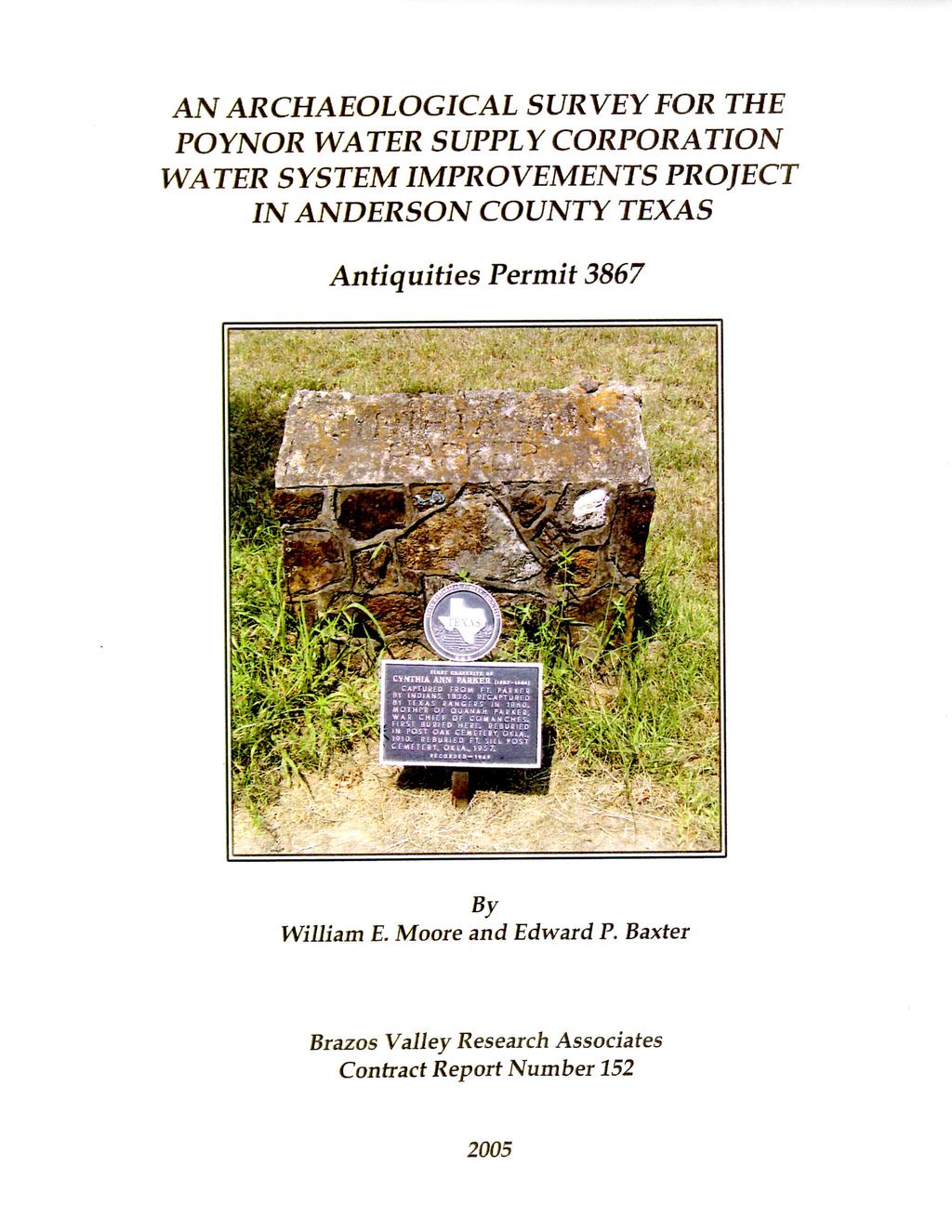
3 ABSTRACT An archaeological survey at several locations along an 8.8-mile (5.3 acres) proposed water line in Anderson County, Texas was performed in August of 2005 by Brazos Valley Research Associates (BVRA) for the Poynor Water Supply Corporation (WSC) under Antiquities Permit The project area was investigated by a field assessment, 100% Pedestrian Survey, and shovel testing and probing. Previously recorded site 41AN14 is depicted on the TARL maps as within the route of the water line. Archival research revealed this plotting is not correct, and this was confirmed by the field survey. No previously unrecorded archaeological sites were found as a result of this investigation. Two cemeteries (Foster and Pleasant Hill) are near the project area. The Foster Cemetery contains graves dating from the 1800s and early 1900s. A State of Texas marker depicts the site of the former grave of Cynthia Ann Parker within this cemetery. Ms. Parker is known for living in captivity with the Comanche Indians and being the mother of Comanche War Chief, Quanah Parker. The Pleasant Hill Cemetery is modern with the oldest grave dating to ii
4 ACKNOWLEDGMENTS The authors are appreciative of the assistance provided by others during this project. Hollie H. Nowlin at J. F. Fontaine & Associates, Inc. was the Project Engineer. She accompanied the Principal Investigator on the field assessment and provided maps and logistical support. The Preisident of the Poynor WSC, William F. Walker, was also very helpful. The background check was conducted by Jean Hughes at TARL. The drafted figures were prepared by Lili Lyddon, and Jennifer McMillan provided technical editing. Nora Rogers proofread the report for errors and consistency. We are especially grateful to C. C. (Kip) Camp of the Anderson County Historical Commission for sharing his knowledge of the Foster Cemetery. iii
5 CONTENTS ABSTRACT...ii ACKNOWLEDGMENTS...iii INTRODUCTION... 1 ENVIRONMENTAL SETTING... 5 ARCHAEOLOGICAL BACKGROUND... 6 METHODS... 7 AREAS SURVEYED... 8 RESULTS AND CONCLUSIONS RECOMMENDATIONS REFERENCES CITED APPENDIX I: Shovel Test Log APPENDIX II: Location of Site 41AN14 FIGURES FIGURE 1. GENERAL LOCATION... 2 FIGURE 2. PROJECT AREA (EAST PORTION)... 3 FIGURE 3. PROJECT AREA (WEST PORTION)... 4 FIGURE 4. AREA FIGURE 5. AREA FIGURE 6. PROPOSED WATERLINE ROUTE (AREA 2) FIGURE 7. AREA FIGURE 8. BANK PROFILE (AREA 3) FIGURE 9. AREA FIGURE 10. FOSTER CEMETERY FIGURE 11. AREA FIGURE 12. PLEASANT HILL CEMETERY iv
6 INTRODUCTION The Poynor WSC plans to install new water line within the rights-of-way of county roads along an 8.8 mile segment of rural Anderson County (Figure 1). Also, a water plant will be constructed on a 100 x 100 site on the east side of County Road The project area is depicted on the USGS topographic map Poynor dated 1978 and revised 1984 (figures 2-3). The water line will be PVC pipe and will vary in size from 2 to 6 in diameter. The line will cross prime farmland, hydric soil, and potential wetlands. It will be installed in the highway ROW parallel to existing lines when possible to provide additional flow and pressure throughout the system. The ditches needed for the pipe will be 6 to 12 wide and will be a minimum of 30 deep. Anderson County is located in a part of Texas that contains numerous prehistoric and historic sites, many of which have been considered to possess significant research potential. This county is in the area once inhabited by the prehistoric Caddo Indians of Northeast Texas. Many of these sites contain burials and pottery vessels of exceptional quality. Vandalism of archaeological sites in this area is a serious problem, and the number of intact Caddoan sites is rapidly decreasing. The Texas Historical Society, Archeology Division, requested a cultural resources survey be performed by a professional archaeologist prior to installation of the water line. In order to comply with this request, the Poynor WSC retained BVRA of Bryan, Texas to conduct this investigation. The project number assigned by BVRA is

7 Figure 1. General Location 2

8 Figure 2. Project Area (East Portion) 3

9 Figure 3. Project Area (West Portion) 4
10 ENVIRONMENTAL SETTING The project area is located within the West Gulf Coastal Plain physiographic province as defined by Fenneman (1946) and the Austropriarian biotic province as defined by Blair (1950:98-100). The reader is referred to Volume I (Stratigraphy) of the Geology of Texas by Sellards et al. (1932) for a more in-depth discussion of the geology of this area. Data taken from the Texas Almanac for (Kingston and Harris 1983) states that the county receives inches of annual rainfall. When combined with a January minimum temperature of 37 degrees Fahrenheit and a July maximum temperature of 94 degrees Fahrenheit, a growing season of 264 days results. Fauna known to be present within the project area at various times of the year include fox and gray squirrel, armadillo, raccoon, opossum, cottontail rabbits, white-tailed deer, coyote, beaver, and feral hogs. Many birds utilize the site including dove, meadowlark, killdeers, various sparrows, great blue herons, bluebirds, mockingbirds, and cardinals. Much of the project area is in upland setting with elevations at or greater than 400 feet above mean sea level. A large portion of the project area was heavily wooded with mixed hardwoods and various kinds of under story vegetation present. Some areas were in pasture. No major creeks cross any of the roads within the project area. Only unnamed tributaries and the upper reaches of tributaries are present. The soils were observed to be sand over firm red clay. 5
11 ARCHAEOLOGICAL BACKGROUND Anderson County is located in the Northeast Texas Archeological Study Region of the Eastern Planning Region as defined by the Department of Antiquities Protection in Archeology in the Eastern Planning Region, Texas: A Planning Document (Kenmotsu and Perttula 1993). According to the planning document, there were 121 sites recorded in the county as of 1991 (Kenmotsu and Perttula 1993:41). In the region, Anderson County was 16th in terms of numbers of sites recorded. Of the 121 recorded sites, 12 were considered not significant, 41 were of unknown significance, 46 were probably significant, and 22 were significant. Two sites (41AN19 and 41AN51) are listed in the National Register of Historic Places. Site 41AN51, the Pace McDonald site, has been discussed in an unpublished manuscript by Thurmond (1978) on file at TARL. At the time of this survey there were approximately 160 recorded prehistoric and historic sites in the county. The Archeological Bibliography for the Northeastern Region of Texas (Martin 1990) cites 50 references for the county. Although many of these investigations have been small area surveys, often resulting in negative findings, several major reservoir projects have been conducted. These are the Blackburn Crossing Reservoir (Johnson 1958, 1961), Palestine Reservoir (Anderson et al. 1974), Tennessee Colony Lake (Richner 1977; Richner and Lee 1976, 1977), Trinity River Basin (Richner and Bagot 1978), and the Trinity River Multiple Use Project (Sorrow 1973). Overviews of the area include works by (Lynott and Richner 1977), Woodall (1972), and Story, et al. (1990). Prehistoric occupations in the region cover all time periods from Paleoindian through Historic Caddoan, circa 9500 B.C. - A.D (Kenmotsu and Perttula 1993:44). The reader is referred to this comprehensive and well organized document for additional information regarding the archaeological background for Anderson County and vicinity. Numerous prehistoric sites have been recorded along Caddo Creek just to the north of the project area in Anderson and Henderson counties and along Caney Branch to the east in Anderson County. Several of these sites were investigated in the 1930s under the direction of A. M. Woolsey and A. T. Jackson of The University of Texas at Austin. Although collections were sometimes curated, site forms and formal reports may not exist. Most of these sites have been described as Caddoan, and some contain burials with grave goods. According to the few site forms that are present, the preferred location for sites appears to be terraces adjacent to streams. Archaic hunting sites were recorded during the Lake Palestine survey in 1960s and early 1970s (Anderson 1971). Sites found during this study were predominantly associated with streamside locations near relatively fertile soils (Anderson 1971:iii). 6
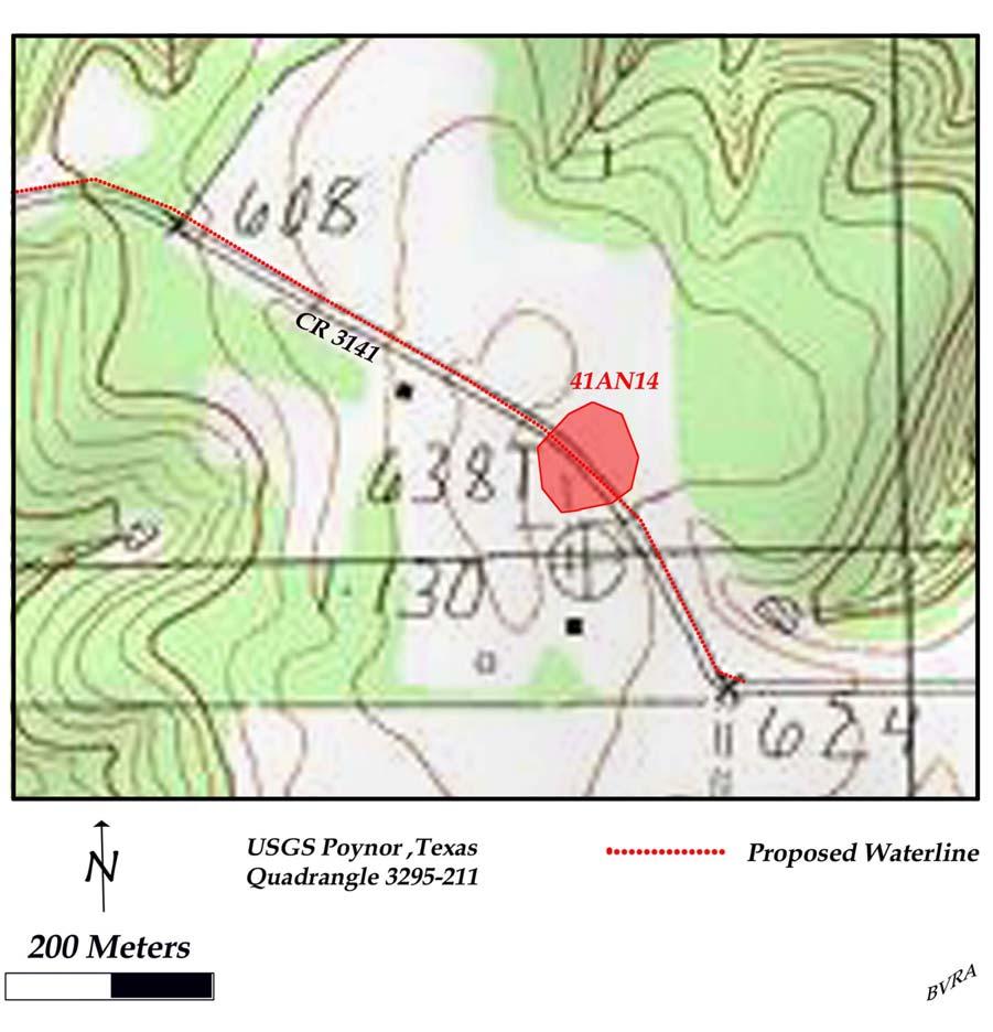
12 METHODS Pre-Field Tasks Prior to entering the field a records check for previously recorded sites in or near the project area was conducted by Jean Hughes at TARL. The Principal Investigator and Project Engineer drove the entire route of the proposed water line in an attempt to identify high probability areas for survey. All creek crossings were evaluated, and one historic cemetery and one modern cemetery were observed. Previously recorded site 41AN14 is depicted on the TARL maps as being within the project area. The field assessment identified this area as an unlikely setting for a prehistoric site based on an absence of a nearby water source. The Principal Investigator and Project Engineer visited the Anderson County Courthouse, Anderson County Tax Appraisal Office, and local abstract office to check land ownership in the project area against the landowners mentioned on the site map for 41AN14. It was learned that the site had been incorrectly plotted on the maps at TARL. Two important reports were reviewed during the planning stages of this project. These are a planning document by the Department of Antiquities Protection (Kenmotsu and Perttula 1993) and an archeological bibliography for the Northeastern Region of Texas (Martin 1990). The interested reader is referred to these sources for additional information regarding the prehistory of this area. Field Tasks The field investigation was conducted on August 2, Five areas selected for survey were investigated. Two creek crossings (Area 2 and Area 3) were investigated through a 100% Pedestrian Survey and shovel probing. Shovel testing was performed in Area 2. Exposed cut banks along the entire length of each of these areas were examined. All dirt excavated by shovel testing was screened using ¼ inch hardware cloth. A shovel test log was maintained (Appendix I), and the approximate location of each test was plotted on the field map. The two cemeteries were visited and photographed. The area where site 41AN14 is plotted on the TARL maps was evaluated. This area was walked, and a careful inspection of the disturbed surface was examined for cultural materials. Two shovel tests were excavated, one on each side of the road. All five areas investigated were documented with a hand-held GPS and photographed with a digital camera. 7
13 AREAS SURVEYED Area 1 This is the area where site 41AN14 is plotted on the maps at TARL (Appendix II) as being on both sides of County Road 3141 (Figure 4). A GPS position was established from the topographic quadrangle plotting, and this area was visited and examined. At the time of this survey, the road was deeply entrenched (2-3 feet) into the sandy soil and had a ditch and sloped bank on each side. A 100% Pedestrian Survey was conducted on both sides of the road the entire length of the plotted site area. Surface visibility was estimated at 60% to 70%. The proposed water line will be placed in the county road ROW. Two shovel tests were excavated, one on each side of the road. Figure 4. Area 1 8

14 Area 2 This area is a creek crossing on the north side of County Road 312 and both banks of an unnamed tributary of Caddo Creek from the western upland margin to the eastern upland margin (Figure 5). In this location the water line will not parallel existing line. New line will be installed. At the time of this survey, the road was deeply cut into the slopes and upland portions of the project area exposing a vertical cut bank profile. A mantle of sand 30 cm to 40 cm thick was present over the underlying red clay (Figure 6). The entire length of this profile along Area 2 was visually examined. The proposed water line will have to be placed in the ditch since the top of the bank was the edge of the ROW and the ditch consists of very hard red clay. Sand deposits were observed east of the creek on a flat terrace on which three houses had been built. Four shovel tests were excavated in this sandy area. Figure 5. Area 2 9

15 Figure 6. Proposed Waterline Route (Area 2) 10
16 Area 3 This area is a creek crossing on the north side of County Road 312 and both banks of an unnamed tributary of Caddo Creek from the western upland margin to the eastern upland margin (Figure 7). In this location the water line will not parallel existing line. New line will be installed. At the time of this survey, the road was deeply cut into the slopes and upland portions of the project area exposing a vertical cut bank profile. A mantle of sand 30 cm to 40 cm thick was present over the underlying red clay (Figure 7). The entire length of this profile along Area 3 was visually examined, and tested with shovel probes. The proposed water line will have to be placed in the ditch since the top of the bank was the edge of the ROW and the ditch was in hard red clay on the slopes and upland areas. Near the creek, shallow over bank deposit sand was present in the ROW, but recent bulldozer work had disturbed the project area allowing for 100% visibility. Figure 7. Area 3 11

17 Figure 8. Bank Profile (Area 3) Area 4 The Foster Cemetery is on the north side of County Road 478 (Figure 9). At the time of this survey, part of the cemetery had been mowed and fenced and was generally well maintained. The entrance to the mowed part of the cemetery is 250 feet from the road along a cleared area (Figure 10). A dense woods lies between the fenced cemetery and the road. Graves were observed in these woods within 10 meters of the road. The ROW and the graves in the woods are only separated by a few strands of barbed wire. In the fenced area, graves dating to the 1800s and early 1900s were observed. A State of Texas Historical Marker depicts the original gravesite of Cynthia Ann Parker. Ms. Parker was the mother of Quanah Parker, war chief of the Comanche. According to Margaret Schmidt Hacker (Handbook of Texas Online), Ms. Parker died near the Anderson and Henderson county line and was buried in Fosterville Cemetery, and there are several references to Fosterville Cemetery on early maps. In 1910, her son Quanah moved her body to the Post Oak Cemetery near Cache, Oklahoma. Her body, as well as that of her son Quanah, were later moved to Fort Sill, Oklahoma in According to C. C. (Kip) Camp of the Anderson County Historical Commission, the fenced cemetery contains the remains of Anglos and Negroes. This investigation was not able to determine if the graves in the woods are part of the fenced cemetery or if these are two different resting places. 12
18 Figure 9. Area 4 13

19 Figure 10. Foster Cemetery 14
20 Area 5 The Pleasant Hill Cemetery is located on the east side of County Road 3141 (Figure 11). The road curves at the southwest corner of the cemetery and comes within four feet of the fence. Currently, only the western one-quarter of the cemetery has graves, and these are separated into a north section and a south section. There are graves at the southwest corner by the road. At the time of this survey, the cemetery was fenced and had been mowed (Figure 12). The earliest grave observed was dated This investigation was unable to determine the ethnicity of this cemetery. Figure 11. Area 5 15

21 Figure 12. Pleasant Hill Cemetery 16
22 RESULTS AND CONCLUSIONS Literature Review The records check at TARL revealed that no professional investigations have been conducted in the project area. Most of the sites recorded in Anderson County were probably located during the Lake Palestine survey (Anderson 1971) and a survey of the Trinity River basin (Richner and Bagot 1978). Both endeavors were conducted by Southern Methodist University. According to Carolyn Spock (personal communication, June 10, 1994), there was a surge of site recording for the county during 1979 (62 sites), 1980 (62 sites), and 1981 (79 sites). Most of these are believed to represent TARL numbers being assigned to previously recorded sites by Southern Methodist University from the Lake Palestine and Trinity River Basin projects. According to the site records at TARL, one prehistoric site (41AN14) lies within the path of the water line as currently proposed. The topographic maps also depict the presence of two cemeteries (Foster and Pleasant Hill) near the path of the water line. Field Survey No previously unrecorded archaeological sites were found as a result of this survey. Previously recorded site 41AN14 was found to be incorrectly plotted on the topographic maps on file at TARL. A site map on file at TARL lists this site as been located on the Gene and Isabel Donnell place. The area where the site is plotted is located in the Robert Myers abstract (A-571, Block Number 705). The records search revealed that no persons named Donnell owned property in this block in the 1930s when the site was investigated by archaeologists from The University of Texas at Austin. Property owned by Frank Donnell during the time this site was investigated was found to be to the north in the Alfred Benge abstract (A-106, Block 707). According to the site records at TARL, 41AN14 is one of a group of sites in Anderson County that were plotted on the topographic maps using only sketchy records. The field survey confirmed the location of the two cemeteries depicted on the topographic map, Foster and Pleasant Hill. In the area of the Foster Cemetery, two separate areas containing graves were identified. One is a fenced and mowed area approximately 250 feet from the county road. This area is identified by a sign at the entrance as the Foster Cemetery. There are additional graves in the woods (not fenced) adjacent to the county road with the nearest grave approximately 10 meters from the road. Mr. Camp of the Anderson County Historical Commission was not aware of this cemetery, and he does not know if it represents a separate resting place or is part of the fenced portion of Foster Cemetery to the north. The fenced cemetery contains the graves of Negroes and Anglo-Americans and dates from the 1800s through early 1900s. 17
23 As discussed above, the site of the former grave of Cynthia Ann Parker is identified by a State of Texas marker. Ms. Parker was the mother of Quanah Parker, famous Comanche war chief. The cemetery in the woods contains graves dating to the 20 th Century, but no attempt was made to record the dates of every grave. Foster Cemetery may be eligible for nomination as a Texas Historic Cemetery. Pleasant Hill is a fenced and mowed cemetery near the community of Pleasant Hill and is adjacent to County Road It contains graves dating to the 20 th Century with the oldest dated at It does not meet the age requirement for nomination as a Texas Historic Cemetery. 18
24 RECOMMENDATIONS Previously recorded site 41AN14 was found to be incorrectly plotted. Therefore, construction of the water line in this area should be allowed to proceed as planned. Two areas containing graves were identified in the area of the Foster Cemetery. Since the area near the road is not fenced, it is recommended that the water line be placed across the road. If the water line is placed on the same side of the road as the cemetery, scraping under the supervision of a professional archaeologist is recommended. The Pleasant Hill Cemetery was found to be fenced and modern in age (1960s and later). Since the water line will be placed across the road from this cemetery, no scraping or monitoring is necessary. It is recommended that no restrictions be placed on the installation of the water line in the remainder of the project area. 19
25 REFERENCES CITED Anderson, Keith M Archaeological Resources of Lake Palestine, Texas. Report submitted by Southern Methodist University to the National Park Service Anderson, Keith M., Kathleen Gilmore, Olin F. McCormick, III, and E. Pierre Morenon 1974 Archaeological Investigations at Lake Palestine Texas. Southern Methodist University, Institute for the Study of Earth and Man, Department of Anthropology, Contributions in Anthropology Number 11. Blair, W. Frank 1950 The Biotic Provinces of Texas. The Texas Journal of Science 2(1): Fenneman, Nevin M Physical Divisions of the United States Map. United States Geological Survey, Washington, D.C. Johnson, LeRoy, Jr Appraisal of the Archeological Resources of Blackburn Crossing Reservoir, Anderson, Cherokee, Henderson, and Smith Counties, Texas. Archeological Salvage Program, National Park Service, Austin Office An Archeological Survey of Blackburn Crossing Reservoir on the Upper Neches River. Bulletin of the Texas Archeological Society 31: Kentmotsu, Nancy Adele, and Timothy K. Perttula 1993 Archeology in the Eastern Planning Region, Texas: A Planning Document. Department of Antiquities Protection, Cultural Resources Management Report 3. Texas Historical Commission. Kingston, Michael T., and Ruth Harris (Editors) Texas Almanac and State Industrial Guide. Dallas Morning News. Lynott, Mark J., and Jeffrey J. Richner 1977 An Archaeological Overview of East-Central Texas. Manuscript prepared by Methodist University on file at the Texas Historical Commission in Austin, Texas. Martin, William A Archeological Bibliography for the Northeastern Region of Texas. Department of Planning and Review, Cultural Resource Management Report 1 and Office of the State Archeologist Special Report
26 Richner, Jeffrey J Archeological and Ethnohistorical Survey at Tennessee Colony Lake. Archaeology Research Program, Southern Methodist University. Dallas. Richner, Jeffrey J., and Joe T. Bagot (Assemblers) 1978 A Reconnaissance Survey of the Trinity River Basin, Archaeology Research Program, Southern Methodist University, Research Report 113. Richner, Jeffrey J., and Reed Lee 1976 Cultural Resources at Tennessee Colony Lake. Archaeology Research Southern Methodist University Archaeological and Ethnohistorical Survey at Tennessee Colony Lake, Archaeology Research Program, Southern Methodist University. Sellards, E. H., W. S. Adkins, and F. B. Plummer 1932 The Geology of Texas, Volume I, Stratigraphy. The University of Texas, Bureau of Economic Geology, Bulletin Sorrow, William M Preliminary Archeological Reconnaissance of the Selected Area to be Affected by the Trinity River Multiple Purpose Project, Texas. Texas Archeological Salvage Project, Research Report 17. The University of Texas at Austin. Story, Dee Ann, Janice A. Guy, Barbara A. Burnett, Marthy Doty Freeman, Jerome C. Rose, D. Gentry Steele, Ben W. Olive, and Karl G. Reinhard 1990 the Archeology and Bioarcheology of the Gulf Coastal Plain. Arkansas S Survey, Research Series Number 38. Fayetteville. Thurmond, J. Peter 1978 The Pace McDonald Site: A Caddoan Mound Center in Anderson County, Texas. Unpublished manuscript on file at the Texas Archeological Research Laboratory in Austin, Texas. Woodall, J. Ned 1972 Prehistoric Social Boundaries: An Archeological Model and Test. Bulletin of the Texas Archeological Society 43:
27 APPENDIX I: SHOVEL TEST LOG Test Depth Soils Comments Area cm sand over clay Dug in right-of-way and ditch 2 50 cm sand over clay Dug in right-of-way and ditch Area cm sand over clay Dug in right-of-way and ditch 2 50 cm sand over clay Dug in right-of-way and ditch 3 40 cm sand over clay Dug in right-of-way and ditch 4 30 cm sand over clay Dug in right-of-way and ditch
28 APPENDIX II: LOCATION OF SITE 41AN14
29
AN ARCHAEOLOGICAL SURVEY FOR THE DCP MIDSTREAM THREE RIVERS PLANT TO CGP 51 PROJECT IN LIVE OAK COUNTY, TEXAS
 AN ARCHAEOLOGICAL SURVEY FOR THE DCP MIDSTREAM THREE RIVERS PLANT TO CGP 51 PROJECT IN LIVE OAK COUNTY, TEXAS By William E. Moore Brazos Valley Research Associates Contract Report Number 251 2011 AN ARCHAEOLOGICAL
AN ARCHAEOLOGICAL SURVEY FOR THE EASTHAM STATE PRISON FARM UNIT PROJECT IN HOUSTON COUNTY TEXAS
 AN ARCHAEOLOGICAL SURVEY FOR THE EASTHAM STATE PRISON FARM UNIT PROJECT IN HOUSTON COUNTY TEXAS Antiquities Permit 5693 By William E. Moore and Edward P. Baxter Brazos Valley Research Associates Contract
AN ARCHAEOLOGICAL SURVEY FOR THE EASTHAM STATE PRISON FARM A-1 and 7-1 WELL LOCATIONS IN HOUSTON COUNTY TEXAS
 AN ARCHAEOLOGICAL SURVEY FOR THE EASTHAM STATE PRISON FARM A-1 and 7-1 WELL LOCATIONS IN HOUSTON COUNTY TEXAS Antiquities Permit 4813 By William E. Moore Brazos Valley Research Associates Contract Report
AN ARCHAEOLOGICAL SURVEY OF THE PROPOSED VETERANS RETIREMENT HOME PROJECT IN CENTRAL SOMERVELL COUNTY, TEXAS. Texas Antiquities Permit Number 2950
 AN ARCHAEOLOGICAL SURVEY OF THE PROPOSED VETERANS RETIREMENT HOME PROJECT IN CENTRAL SOMERVELL COUNTY, TEXAS Texas Antiquities Permit Number 2950 by William E. Moore Brazos Valley Research Associates Contract
AN ARCHAEOLOGICAL SURVEY FOR THE COLEMAN COUNTY SPECIAL UTILITY DISTRICT PHASE 7 WATER LINE PROJECT IN COLEMAN COUNTY TEXAS
 AN ARCHAEOLOGICAL SURVEY FOR THE COLEMAN COUNTY SPECIAL UTILITY DISTRICT PHASE 7 WATER LINE PROJECT IN COLEMAN COUNTY TEXAS Antiquities Permit 5057 By William E. Moore Brazos Valley Research Associates
Archaeological Survey and Assessment of Four Wastewater Interceptor Routes in Garner, Wake Co., N.C. (EPA C )
") Archaeological Survey and Assessment of Four Wastewater Interceptor Routes in Garner, Wake Co., N.C. (EPA C370623-02) By H. Trawick \vard R. P. Stephen Davis Prepared by the Research Laboratories of Anthropology
Archaeological Survey and Assessment of Four Wastewater Interceptor Routes in Garner, Wake Co., N.C. (EPA C370623-02) By H. Trawick \vard R. P. Stephen Davis Prepared by the Research Laboratories of Anthropology
PW Parkway ES Prince William County, Virginia WSSI #
 PW Parkway ES Prince William County, Virginia WSSI #15.3 Cultural Resources Site Assessment November 15 Prepared for: Prince William County Public Schools P.O. Box 39 Manassas, Virginia 1 Prepared by:
AN ARCHAEOLOGICAL SURVEY FOR THE GREENHOUSE ROAD PROJECT IN WESTERN HARRIS COUNTY, TEXAS. Brazos Valley Research Associates. Project Number 07-16
 AN ARCHAEOLOGICAL SURVEY FOR THE GREENHOUSE ROAD PROJECT IN WESTERN HARRIS COUNTY, TEXAS Brazos Valley Research Associates Project Number 07-16 Principal Investigator: William E. Moore Prepared for Bureau
AN ARCHAEOLOGICAL SURVEY OF SUEMAUR EXPLORATION & PRODUCTION LLC s PRIDE PROSPECT IN GALVESTON COUNY TEXAS
 AN ARCHAEOLOGICAL SURVEY OF SUEMAUR EXPLORATION & PRODUCTION LLC s PRIDE PROSPECT IN GALVESTON COUNY TEXAS By William E. Moore Brazos Valley Research Associates Contract Report Number 195 2008 AN ARCHAEOLOGICAL
A CULTURAL RESOURCES SURVEY FOR CITY OF NATALIA WASTEWATER IMPROVEMENT PROJECT IN MEDINA COUNTY, TEXAS
 A CULTURAL RESOURCES SURVEY FOR CITY OF NATALIA WASTEWATER IMPROVEMENT PROJECT IN MEDINA COUNTY, TEXAS Antiquities Permit 7473 By William E. Moore (Principal Investigator) Brazos Valley Research Associates
City of Lockport Historic Resources Survey - Section METHODOLOGY
 2.0 METHODOLOGY Clinton Brown Company PN 07-008 2-1 April 2011 2.0 METHODOLOGY This methodology statement is prepared as part of the project tasks. It outlines the research sources identified, field strategies,
AN ARCHAEOLOGICAL SURVEY FOR CGG VERITAS MIDDLETON RANCH 3-D SEISMIC SURVEY IN CHAMBERS COUNTY, TEXAS. BVRA Project Number 10-21
 AN ARCHAEOLOGICAL SURVEY FOR CGG VERITAS MIDDLETON RANCH 3-D SEISMIC SURVEY IN CHAMBERS COUNTY, TEXAS BVRA Project Number 10-21 Principal Investigator William E. Moore Prepared for CGG Veritas 10300 Town
David Moore, PacifiCorp Cultural Resources Coordinator Denise DeJoseph, Project Archaeologist
 References DeJoseph, Denise 2011 Lewis River HPMP: Swift Camp FSC Survey Negative Results. Memo report submitted by Historical Research Associates to PacifiCorp, Portland, Oregon. Copies available at PacifiCorp,
ADDITIONAL PHASE IA ARCHAEOLOGICAL SURVEY FOR THE UMORE PARK SAND AND GRAVEL MINING ENVIRONMENTAL REVIEW SERVICES, DAKOTA COUNTY, MINNESOTA
 ADDITIONAL PHASE IA ARCHAEOLOGICAL SURVEY FOR THE UMORE PARK SAND AND GRAVEL MINING ENVIRONMENTAL REVIEW SERVICES, DAKOTA COUNTY, MINNESOTA ADDENDUM I Submitted to: Short Elliot Hendrickson, Inc. Submitted
4.3 CULTURAL RESOURCES
 4.3 CULTURAL RESOURCES This section of the EIR analyzes the proposed project s potential impacts on archaeological and paleontological resources. This analysis summarizes the findings of the Archaeological
ENGINEER S CERTIFICATION OF FAULT AREA DEMONSTRATION (40 CFR )
") PLATTE RIVER POWER AUTHORITY RAWHIDE ENERGY STATION BOTTOM ASH TRANSFER (BAT) IMPOUNDMENTS LARIMER COUNTY, CO ENGINEER S CERTIFICATION OF FAULT AREA DEMONSTRATION (40 CFR 257.62) FOR COAL COMBUSTION RESIDUALS
PLATTE RIVER POWER AUTHORITY RAWHIDE ENERGY STATION BOTTOM ASH TRANSFER (BAT) IMPOUNDMENTS LARIMER COUNTY, CO ENGINEER S CERTIFICATION OF FAULT AREA DEMONSTRATION (40 CFR 257.62) FOR COAL COMBUSTION RESIDUALS
ACTON COMMUNITY WIDE ARCHAEOLOGICAL RECONNAISSANCE SURVEY. Town of Acton and PAL, Inc.
 ACTON COMMUNITY WIDE ARCHAEOLOGICAL RECONNAISSANCE SURVEY Town of Acton and PAL, Inc. Objectives and Scope of Work Four phase study; (1. research, 2. draft report outline, resource protection bylaw, 3.
THE TWO MOST SIGNIFICANT ARCHEOLOGICAL SITES IN KERR COUNTY, TEXAS ARE THE GATLIN SITE AND THE BEARING SINK HOLE SITE.
 WHAT ARE THE MOST IMPORTANT ARCHEOLOGY SITES IN KERR COUNTY? By Steve Stoutamire THE TWO MOST SIGNIFICANT ARCHEOLOGICAL SITES IN KERR COUNTY, TEXAS ARE THE GATLIN SITE AND THE BEARING SINK HOLE SITE. Map
Archaeological Test Excavations at 41KF118 Kaufman County, Texas
 Index of Texas Archaeology: Open Access Gray Literature from the Lone Star State Volume 1990 Article 14 1990 Archaeological Test Excavations at 41KF118 Kaufman County, Texas John W. Clark, Jr. Follow this
KANSAS GEOLOGICAL SURVEY Open File Report LAND SUBSIDENCE KIOWA COUNTY, KANSAS. May 2, 2007
 KANSAS GEOLOGICAL SURVEY Open File Report 2007-22 LAND SUBSIDENCE KIOWA COUNTY, KANSAS Prepared by Michael T. Dealy L.G., Manager, Wichita Operations SITE LOCATION The site was approximately four miles
AN ARCHAEOLOGICAL SURVEY FOR THE FORT GRIFFIN SPECIAL UTILITY DISTRICT WATER IMPROVEMENT PROJECT IN CALLAHAN AND EASTLAND COUNTIES, TEXAS
 AN ARCHAEOLOGICAL SURVEY FOR THE FORT GRIFFIN SPECIAL UTILITY DISTRICT WATER IMPROVEMENT PROJECT IN CALLAHAN AND EASTLAND COUNTIES, TEXAS Antiquities Permit 6236 By William E. Moore Brazos Valley Research
4.11 CULTURAL RESOURCES
 4.11 CULTURAL RESOURCES 4.11 CULTURAL RESOURCES This section summarizes the cultural resources of. Information reviewed for the summary includes the General Plan, published reports on archaeological research
Additional Testing for Padre Dam Eastern Service Area Secondary Connection- Alternative Site Location, San Diego County, California
 Mark Niemiec Padre Dam Municipal Water District P.O. Box 719003 9300 Fanita Parkway Santee, California 92072 Re: Additional Testing for Padre Dam Eastern Service Area Secondary Connection- Alternative
Sacred Lands File & Native American Contacts List Request
 Sacred Lands File & Native American Contacts List Request NATIVE AMERICAN HERITAGE COMMISSION 915 Capitol Mall, RM 364 Sacramento, CA 95814 (916) 653-4082 (916) 657-5390 Fax nahc@pacbell.net Information
IN THE UNITED STATES DISTRICT COURT FOR THE DISTRICT OF COLUMBIA DECLARATION OF TIM MENTZ, SR. IN SUPPORT OF MOTION FOR TEMPORARY RESTRAINING ORDER
 IN THE UNITED STATES DISTRICT COURT FOR THE DISTRICT OF COLUMBIA STANDING ROCK SIOUX TRIBE, Plaintiff, Case No. 1:16-cv-1534-JEB v. U.S. ARMY CORPS OF ENGINEERS, Defendant. DECLARATION OF TIM MENTZ, SR.
Waterbury Dam Disturbance Mike Fitzgerald Devin Rowland
 Waterbury Dam Disturbance Mike Fitzgerald Devin Rowland Abstract The Waterbury Dam was completed in October 1938 as a method of flood control in the Winooski Valley. The construction began in April1935
Appendix I-1: Archaeological Records Search
 Appendix I-1: Archaeological Records Search South Central Coastal Information Center California State University, Fullerton Department of Anthropology MH-426 800 North State College Boulevard Fullerton,
CHAPTER 4. Blue Heron Site (47Je1001) 2003 Investigations. By Chrisie L. Hunter
 2003 Investigations. By Chrisie L. Hunter") CHAPTER 4 Blue Heron Site (47Je1001) 2003 Investigations By Chrisie L. Hunter Introduction The Blue Heron site (47Je1001) is on the property of the Crescent Bay Hunt Club, which is located in the NE 1/4
CHAPTER 4 Blue Heron Site (47Je1001) 2003 Investigations By Chrisie L. Hunter Introduction The Blue Heron site (47Je1001) is on the property of the Crescent Bay Hunt Club, which is located in the NE 1/4
This material is part of the collection of the Philadelphia Water Department and was downloaded from the website Please contact the
 This material is part of the collection of the Philadelphia Water Department and was downloaded from the website www.phillyh2o.org Please contact the PhillyH2O webmaster for more information about this
2007 Raleigh Colony Investigation: Magnetic Anomaly Identification & Assessment Roanoke Sound and Shallowbag Bay Roanoke Island, North Carolina
 2007 Raleigh Colony Investigation: Magnetic Anomaly Identification & Assessment Roanoke Sound and Shallowbag Bay Roanoke Island, North Carolina 2007 Raleigh Colony Investigation: Magnetic Anomaly Identification
The subject paper is being submitted for approval for publication in the annual volume entitled Geological Survey Research.
 Water Resources Division 345 Middlefield Road Menlo Park, California January 12, 1965 Memorandum To: Mr. Frank E. Clark, Chief, General Hydrology Branch Thru: Area Hydrologist PCA From: Valmore C. LaMarche
General Editor: Vince Russett
 YCCCART 2014/Y20 North Somerset HER 2015/11 Manual survey using an electronic, hydryostatic level (NIVCOMP) at Wemberham Roman Villa YATTON, CONGRESBURY, CLAVERHAM AND CLEEVE ARCHAEOLOGICAL RESEARCH TEAM
Regional Geomorphology
 Chapter 2 Environmental Setting Regional Geomorphology The study area is set in the floodplain of the Mississippi River, just south of Plaquemine, Louisiana. The river has occupied its current position
Advanced Geologic Exploration, Inc.
 Advanced Geologic Exploration, Inc. Scientists of the Earth PO Box 1956, Chester, CA 96020 Voice: (530) 258-4228 Fax (530) 258-4339 www.advancedgeologic.com January 23, 2009 Job No. G-081201 Terri Barber,
MAPS AND THEIR CLASSIFICATION
 MAPPING MAPS AND THEIR CLASSIFICATION WHAT IS A MAP? A map is representation of the Earth's surface, showing how things are related to each other by distance, direction, and size. Maps are a way of showing
ARCHAEOLOGICAL SURVEY OF BANDERA CITY PARK, BANDERA COUNTY, TEXAS
 ARCHAEOLOGICAL SURVEY OF BANDERA CITY PARK, BANDERA COUNTY, TEXAS Ronald W. Burkett I / Center for Archaeological Research The University of Texas at San Antonio Archaeological Survey Report, No. 183 1989
Part 1: Buildings to be Demolished. Submitted to
 Stage 1 & 2 Archaeological Assessment London Psychiatric Hospital 850 Highbury Avenue North City of London (Former London Township) Middlesex County, Ontario Part 1: Buildings to be Demolished Submitted
Starting at Rock Bottom: A Peculiar Central Texas PreClovis Culture
 Starting at Rock Bottom: A Peculiar Central Texas PreClovis Culture Background Brushy Creek grades, overall, west-northwest (WNW) to east-southeast (ESE) through the easternmost portions of the central
SITE SUMMARY REPORT Candor Dump NONCD Montgomery County
 SITE SUMMARY REPORT Candor Dump NONCD 0000433 Montgomery County Senate Bill 1492 State of North Carolina State Contract N06009S Schnabel Project No. 06210002.23 February 23, 2010 Prepared for: North Carolina
Project Background. March 9, Commissioners of Public Works 103 Saint Phillip Street Charleston, South Carolina 29203
 March 9, 2016 Commissioners of Public Works 103 Saint Phillip Street Charleston, South Carolina 29203 Attention: Reference: Mr. Frank Crawford Historic and Archaeological Properties Survey Dear Mr. Crawford:
CHAPTER 28. PHYSIOGRAPHY Cook Inlet Drainages
 PEBBLE PROJECT ENVIRONMENTAL BASELINE DOCUMENT 2004 through 2008 CHAPTER 28. PHYSIOGRAPHY Cook Inlet Drainages PREPARED BY: Knight Piésold Ltd. PHYSIOGRAPHY COOK INLET DRAINAGES TABLE OF CONTENTS TABLE
Template for Sediment and Erosion Control Plan General Instructions. Section Instructions
 Template for Sediment and Erosion Control Plan General Instructions Introduction: Soil erosion and sediment deposition from farmlands can contribute to degraded surface water quality. Sediment delivery
An Evaluation of Pavement Drainage Interstate 64, Rowan-Carter Counties
 Transportation Kentucky Transportation Center Research Report University of Kentucky Year 1984 An Evaluation of Pavement Drainage Interstate 64, Rowan-Carter Counties David L. Allen Herbert F. Southgate
Swaledale and Arkengarthdale Archaeology Group
 Swaledale and Arkengarthdale Archaeology Group Bellerby Moor GPS Earthwork Survey Report prepared by: Tim Laurie and Stephen Eastmead. Swaledale and Arkengarthdale Archaeology Group. January 27/01/2012.
MINNESOTA DEEP TEST PROTOCOL PROJECT
 MINNESOTA DEEP TEST PROTOCOL PROJECT Mn/DOT Agreement No. 85878 OSA License No. 04-030 Authorized and Sponsored by: MINNESOTA DEPARTMENT OF TRANSPORTATION FEDERAL HIGHWAY ADMINISTRATION Prepared by COMMONWEALTH
CASE STUDY #9 - Brushy Fork Dam, Sugar Grove, West Virginia
 CASE STUDY #9 - Brushy Fork Dam, Sugar Grove, West Virginia Brushy Fork Dam is a flood control structure built by the Soil Conservation Service southeast of the city of Franklin in Pendleton County, West
HONDURAN INSTITUTE OF ANTHROPOLOGY AND HISTORY SURFACE SURVEY NUEVA ARCADIA AND LA COFRADÍA WIND PROJECT
 HONDURAN INSTITUTE OF ANTHROPOLOGY AND HISTORY SURFACE SURVEY NUEVA ARCADIA AND LA COFRADÍA WIND PROJECT PROVINCE OF FRANCISCO MORAZAN Prepared for The Sub Management of Heritage I.H.A.H. II. Researcher:
Identification of Lateral Spread Features in the Western New Madrid Seismic Zone J. David Rogers and Briget C. Doyle
 Identification of Lateral Spread Features in the Western New Madrid Seismic Zone J. David Rogers and Briget C. Doyle Department of Geological Engineering University of Missouri-Rolla rogersda@umr.edu doyle@hope.edu
Draft exercise for share fair at Bozeman workshop only. This exercise is not ready for distribution. Please send helpful suggestions to
 Draft exercise for share fair at Bozeman workshop only. This exercise is not ready for distribution. Please send helpful suggestions to foleyd@plu.edu Figure list 1. Trailer photograph 2. Location map
Land at Model Farm Cottages, Bath Road, Sonning, Berkshire
 Land at Model Farm Cottages, Bath Road, Sonning, Berkshire An Archaeological Evaluation for The Keen Partnership by Andy Taylor Thames Valley Archaeological Services Ltd Site Code BRS 04/55 June 2004 Summary
8 th 12 th Designing a Monitoring Plan Mapping & Analysis (Activities 1 2)
") 8 th 12 th Designing a Monitoring Plan Mapping & Analysis (Activities 1 2) Objectives for All Activities - To be able to define and describe the purpose and uses of topographic maps. - To define rules
8 th 12 th Designing a Monitoring Plan Mapping & Analysis (Activities 1 2) Objectives for All Activities - To be able to define and describe the purpose and uses of topographic maps. - To define rules
Re: Steep Slope Assessment for 2465 Waverly Drive, Blind Bay, BC; Legal Address: Lot 39, Section 18, Township 22, Range 10, Plan 25579, W6M, KDYD.
 OEL File 1563-1 May 30, 2017 Doug Wall PO Box 774 Salmon Arm, BC V1E 4N7 Re: Steep Slope Assessment for 2465 Waverly Drive, Blind Bay, BC; Legal Address: Lot 39, Section 18, Township 22, Range 10, Plan
August 14, James Bolton 312 Perry Lane Lovingston, VA
 August 14, 2017 James Bolton 312 Perry Lane Lovingston, VA 22949 jrbolton035@gmail.com Department of Environmental Quality Office of Wetlands & Stream Protection P.O. Box 1105 Richmond, VA 23218 comment-acp@deq.virginia.gov
HISTORY OF CONSTRUCTION FOR EXISTING CCR SURFACE IMPOUNDMENT PLANT GASTON ASH POND 40 CFR (c)(1)(i) (xii)
(1)(i) (xii)") HISTORY OF CONSTRUCTION FOR EXISTING CCR SURFACE IMPOUNDMENT PLANT GASTON ASH POND 40 CFR 257.73(c)(1)(i) (xii) (i) Site Name and Ownership Information: Site Name: E.C. Gaston Steam Plant Site Location:
HISTORY OF CONSTRUCTION FOR EXISTING CCR SURFACE IMPOUNDMENT PLANT GASTON ASH POND 40 CFR 257.73(c)(1)(i) (xii) (i) Site Name and Ownership Information: Site Name: E.C. Gaston Steam Plant Site Location:
December 13, Kirk Shields Green Mountain Power 163 Acorn Lane Colchester, VT 05446
 December 13, 2017 Kirk Shields Green Mountain Power 163 Acorn Lane Colchester, VT 05446 RE: End of Field Letter for Archaeological Phase II Site Evaluation at Site VT-CH-1218 within the Proposed Milton
The Rising Sun, Guildford Road, Fetcham, Surrey
 The Rising Sun, Guildford Road, Fetcham, Surrey An Archaeological Evaluation for Bovis Homes Limited by Steve Ford Thames Valley Archaeological Services Ltd Site Code RGF04/80 March 2005 Summary Site name:
Archaeological Monitoring of Construction of a Six-Inch Force Main Sewer over Lookout Creek, Chattanooga, Hamilton County, Tennessee
 A Report Prepared for Hamilton County Engineering Department 300 Newell Tower 117 East Seventh Street Chattanooga, Tennessee 37402 Archaeological Monitoring of Construction of a Six-Inch Force Main Sewer
A River Runs Through It
 A River Runs Through It Once you find the geocache, click "Found It" on the Geocaching.com app and then read and answer the questions below. Make sure to return the cache to exactly the same place you
[LLAZC03000.L EA0000 LVRCA13SA A, AZ SRP Notice of Temporary Closures of Public Lands in La Paz County, AZ
 This document is scheduled to be published in the Federal Register on 01/15/2013 and available online at http://federalregister.gov/a/2013-00542, and on FDsys.gov 4310-32-P DEPARTMENT OF THE INTERIOR Bureau
An Introduction to Field Explorations for Foundations
 An Introduction to Field Explorations for Foundations J. Paul Guyer, P.E., R.A. Paul Guyer is a registered mechanical engineer, civil engineer, fire protection engineer and architect with over 35 years
APPENDIX E. GEOMORPHOLOGICAL MONTORING REPORT Prepared by Steve Vrooman, Keystone Restoration Ecology September 2013
 APPENDIX E GEOMORPHOLOGICAL MONTORING REPORT Prepared by Steve Vrooman, Keystone Restoration Ecology September 2 Introduction Keystone Restoration Ecology (KRE) conducted geomorphological monitoring in
MISSOURI DEPARTMENT OF NATURAL RESOURCES MISSOURI STATE HISTORIC PRESERVATION OFFICE (SHPO) ARCHAEOLOGICAL SITE RECORDATION
 ARCHAEOLOGICAL SITE RECORDATION") MISSOURI DEPARTMENT OF NATURAL RESOURCES MISSOURI STATE HISTORIC PRESERVATION OFFICE (SHPO) ARCHAEOLOGICAL SITE RECORDATION 1. COUNTY 2. SHPO SITE NUMBER 3. LOCAL NAME / NUMBER 4. SECTION / LAND GRANT
MISSOURI DEPARTMENT OF NATURAL RESOURCES MISSOURI STATE HISTORIC PRESERVATION OFFICE (SHPO) ARCHAEOLOGICAL SITE RECORDATION 1. COUNTY 2. SHPO SITE NUMBER 3. LOCAL NAME / NUMBER 4. SECTION / LAND GRANT
IV. Excavation and Analysis of Human Remains
 IV. Excavation and Analysis of Human Remains Excavation and Analysis of Human Remains Introduction...80 Burial Site Identification...80 Cataloging Burial Sites...82 Excavation of Human Remains...84 Documentation
Archaeological Survey and Evaluation at 8954 El Dorado Parkway, El Cajon, San Diego County, California
 April 16, 2013 Ms. Andrea Bitterling Helix Environmental Planning, Inc. 7578 El Cajon Blvd., Suite 200 El Cajon, California 91942 Re: Archaeological Survey and Evaluation at 8954 El Dorado Parkway, El
National Register of Historic Places Registration Form
 United States Department of the Interior National Park Service National Register of Historic Places Registration Form This form is for use in nominating or requesting determinations for individual properties
Prairie View A&M University Cemetery. By Rene DeLaFuente, Tammy Oldani, Stacey Rogers
 Prairie View A&M University Cemetery By Rene DeLaFuente, Tammy Oldani, Stacey Rogers Objective Complete the plotting of all headstones in the modern cemetery, including Total Station data and photographs,
ARCHAEOLOGICAL SURVEY OF THE NEWfON GROVE 230 kv TAP LINE IN SAMPSON COUNTY, NORTH CAROLINA
 ARCHAEOLOGICAL SURVEY OF THE NEWfON GROVE 230 kv TAP LINE IN SAMPSON COUNTY, NORTH CAROLINA by H. Trawick Ward R. P. Stephen Davis, Jr. Research Laboratories of Anthropology University of North Carolina
Geomorphology and Archaeology: Case Studies from Western New York
 Geomorphology and Archaeology: Case Studies from Western New York New York Archaeological Council Fall Meeting Saturday October 1, 2011 Douglas J. Perrelli Geomorphology and Archaeology: Case Studies from
Physiographic Provinces (West, Ch. 13)
") Geology 229 Engineering Geology Lecture 13 Physiographic Provinces (West, Ch. 13) The definition of the term Physiography Physiography (n.) The science which treats of the earth's exterior physical features,
Geology 229 Engineering Geology Lecture 13 Physiographic Provinces (West, Ch. 13) The definition of the term Physiography Physiography (n.) The science which treats of the earth's exterior physical features,
June 9, R. D. Cook, P.Eng. Soils Engineer Special Services Western Region PUBLIC WORKS CANADA WESTERN REGION REPORT ON
 PUBLIC WORKS CANADA WESTERN REGION REPORT ON GEOTECHNICAL INVESTIGATION PROPOSED MARTIN RIVER BRIDGE MILE 306.7 MACKENZIE HIGHWAY Submitted by : R. D. Cook, P.Eng. Soils Engineer Special Services Western
Simple Solutions Social Studies Level 2. Level 2. Social Studies. Help Pages
 Level 2 Social Studies 147 148 adobe houses with bricks made of clay and straw ancestor a family member who lived before us appoint choose; leaders can appoint others barter trading one thing for another
Monitoring Report No. 022 GREENCASTLE BURIALS GREEN CASTLE COUNTY DOWN LICENCE NO. N/A PHILIP MACDONALD
 Monitoring Report No. 022 GREENCASTLE BURIALS GREEN CASTLE COUNTY DOWN LICENCE NO. N/A PHILIP MACDONALD Monitoring Report No. 022 Greencastle Burials (SMR No. Down 057:017) Greencastle Co. Down Philip
QUANTITY, MARCH 1962
 BASE-FLOW STUDIES, GUADALUPE RIVER COMAL COUNTY, TEXAS QUANTITY, MARCH 1962 TEXAS WATER COMMISSION BULLETIN 6503 MARCH 1965 TEXAS WATER COMMISSION Joe William D E 0. F. Dent Carter, Chairman Berger, Commissioner
CHAPTER 7 GEOLOGY AND SOILS
 CHAPTER 7 GEOLOGY AND SOILS 7.1 General Geology of the Area Based on the Geological map compiled by Cornec (2002) the area consists of Miocene/Pleistocene deposits as seen in figure 7.1. These are geologically
Colorado Prehistory: A Context For The Southern Colorado River Basin READ ONLINE
 Colorado Prehistory: A Context For The Southern Colorado River Basin READ ONLINE If you are searched for the ebook Colorado Prehistory: A Context for the Southern Colorado River Basin in pdf format, then
Kansas Archaeology Month
 Activities for Discovering Prehistoric Trails TIME: 45 min. Kansas Archaeology Month Discovering Prehistoric Trails This lesson is divided into four sections: instructional goals, advanced preparation,
Archaeological Monitoring of Land at Seacrest, Cliff Drive, Warden, Isle of Sheppey, Kent
 Archaeological Monitoring of Land at Seacrest, Cliff Drive, Warden, Isle of Sheppey, Kent Site Code SEA/WB/15 Report for Kevin & Lesley O Brian Date of report 14/10/2015 SWAT ARCHAEOLOGY Swale and Thames
The Driftless Area. Dave Speer Geography 326
 The Driftless Area Dave Speer Geography 326 Introduction: Wisconsin s landscape is defined by many physical features resulting from continental glaciation. Wisconsin is unique in the fact that it possesses
COLORADO CULTURAL RESOURCE SURVEY Management Data Form Rev. 11/10
 COLORADO CULTURAL RESOURCE SURVEY OAHP1400 Rev. 11/10 A should be completed for each cultural resource recorded during an archaeological survey. Isolated finds and revisits are the exception and they do
MEMORANDUM. wa.tsr..-z.n~.e.s-t.i~at.i.o.ns... Branch... Mr. Webster contends that prior to excavation of the gravel
 TO... J. C. Foweraker 2... Head Gr o w a t er S e c t i on... Hyar....og~~~.~.~vis.ion... wa.tsr..-z.n~.e.s-t.i~at.i.o.ns... Branch... eernment OF BRITISH COLUMBIA MEMORANDUM II 0 PROM A. P. Kohut, Geological
Tenmile Lakes Delta Building Study
 Tenmile Lakes Delta Building Study Since the late 1940 s, Tenmile Lakes has seen a sharp increase in sediment accumulation at the mouths of the tributaries that feed the lake. To monitor this sediment
Geophysical Survey. Ballymount Co. Dublin. Licence Ref. 02R029. By John Nicholls Margaret Gowen & Co. Ltd. For LRT
 Geophysical Survey Ballymount Co. Dublin Licence Ref. 02R029 By John Nicholls Margaret Gowen & Co. Ltd. For LRT 4 th April 2002 Illustrations List of Figures Figure 1 Site Location 1: 50000 Figure 2 Survey
This report was prepared by Klohn Crippen Consultants Ltd. for Alberta Transportation Central Region under Contract No. CE053/2000.
 Alberta Transportation Central Region #401, 4902 51 Street Red Deer, Alberta T4N 6K8 June 7, 2002 Mr. Melvin Mayfield, P.Eng. Project Engineer Dear Mr. Mayfield: Central Region Landslide Assessment Site
APPENDIX 1 LITTLE EGYPT FROM THE AIR
 APPENDIX 1 LITTLE EGYPT FROM THE AIR FIGURE 1. In this 1930 City of Dallas aerial photo, the land surrounding Little Egypt is seen as cultivated fields and agricultural structures. The Hill property is
,Baynes Lake. TO...?&.?...A 2...KO.?'!!&... Sr. *logical Engineer
 > i evernment OF BRITISH COLUMBIA a TO...?&.?...A 2....KO.?'!!&... Sr. *logical Engineer... Grou,,water. Section Hydrology Division Wat.er... In~.~s.tiga.ti.On.s..Branck.... 5 u BJECT...C;.roun.dw.ater...Snve
[LLAZC X.L EA0000; AZ SRP ] Notice of Temporary Closures: Selected Public Lands in La Paz County, AZ
![[LLAZC X.L EA0000; AZ SRP ] Notice of Temporary Closures: Selected Public Lands in La Paz County, AZ](/thumbs/89/100188672.jpg "[LLAZC X.L EA0000; AZ SRP ] Notice of Temporary Closures: Selected Public Lands in La Paz County, AZ") This document is scheduled to be published in the Federal Register on 12/29/2017 and available online at https://federalregister.gov/d/2017-28217, and on FDsys.gov 4310-32 DEPARTMENT OF THE INTERIOR Bureau
This document is scheduled to be published in the Federal Register on 12/29/2017 and available online at https://federalregister.gov/d/2017-28217, and on FDsys.gov 4310-32 DEPARTMENT OF THE INTERIOR Bureau
Name: Date: Class: Louisiana: Our History, Our Home Chapter 1: Louisiana s Geography - Section 2: Natural Regions Guided Reading
 Instructions: Read the section and complete each item with words from the passages in this section. 1. The diversity of Louisiana s can surprise residents and visitors alike. 2. Physical geography is concerned
APPENDIX 3B OCCURRENCE OF SIGNIFICANT RIVER ALLUVIUM AQUIFERS IN THE PLATEAU REGION
 Plateau Region Water Plan January 2011 APPENDIX 3B OCCURRENCE OF SIGNIFICANT RIVER ALLUVIUM AQUIFERS IN THE PLATEAU REGION Occurrence of Significant River Alluvium Aquifers in the Plateau Region Prepared
GUIDELINES FOR SITE AND UPDATE FORMS. 1. Site forms in a database format should be filed with the Illinois State Museum (ISM).
.") GUIDELINES FOR SITE AND UPDATE FORMS GENERAL 1. Site forms in a database format should be filed with the Illinois State Museum (ISM). 2. Information submitted should be accompanied by a full-scale xerox
GUIDELINES FOR SITE AND UPDATE FORMS GENERAL 1. Site forms in a database format should be filed with the Illinois State Museum (ISM). 2. Information submitted should be accompanied by a full-scale xerox
IV. ENVIRONMENTAL IMPACT ANALYSIS G. GEOLOGY AND SOILS
 IV. ENVIRONMENTAL IMPACT ANALYSIS G. GEOLOGY AND SOILS The following section is a summary of the geotechnical report conducted for the proposed project. The Report of Geotechnical Investigation Proposed
Climate. Annual Temperature (Last 30 Years) January Temperature. July Temperature. Average Precipitation (Last 30 Years)
 January Temperature. July Temperature. Average Precipitation (Last 30 Years)") Climate Annual Temperature (Last 30 Years) Average Annual High Temp. (F)70, (C)21 Average Annual Low Temp. (F)43, (C)6 January Temperature Average January High Temp. (F)48, (C)9 Average January Low Temp.
Climate Annual Temperature (Last 30 Years) Average Annual High Temp. (F)70, (C)21 Average Annual Low Temp. (F)43, (C)6 January Temperature Average January High Temp. (F)48, (C)9 Average January Low Temp.
1.1 What is Site Fingerprinting?
 Site Fingerprinting Utilizing GIS/GPS Technology 1.1 What is Site Fingerprinting? Site fingerprinting is a planning tool used to design communities where protection of natural resources is the primary
1.0 INSPECTION ANNUAL INSPECTION, JUNE 29, 2011 CARMACKS COPPER PROJECT, CARMACKS, YUKON. Dear Mr. West-Sells,
 Doc. No. 162 Rev. 0 Mr. Paul West-Sells President & Chief Operating Officer Western Copper Corporation 2060-1111 West Georgia Street Vancouver, BC V6E 4M3 ANNUAL INSPECTION, JUNE 29, 2011 CARMACKS COPPER
Red River Levee Panel
 Red River Levee Panel Mississippi River Commission Monday, August 9, 2017 Red River Levees in LA & AR NONE along TX & OK Boarder Red River Levee Issues Caddo Levee Cherokee Park Authorization Bossier Levee
Lecture 9: Reference Maps & Aerial Photography
 Lecture 9: Reference Maps & Aerial Photography I. Overview of Reference and Topographic Maps There are two basic types of maps? Reference Maps - General purpose maps & Thematic Maps - maps made for a specific
Written by Vowery Dodd Carlile and Traci Burnett Illustrated by Karen Birchak
 Written by Vowery Dodd Carlile and Traci Burnett Illustrated by Karen Birchak Table of Contents INTRODUCTION...5 TO THE TEACHER...6 STORIES ABOUT TEXAS: Background, Vocabulary Activities, Discussion Questions,
GIS and GPS Utilization in Archaeological Survey at MCB Quantico
 GIS and GPS Utilization in Archaeological Survey at MCB Quantico John H. Haynes, M.A., R.P.A. Archaeologist MCB, Quantico, NREA, NEPA Coordination Section GIS and Background Study: Setting the Context
The Little Colorado River
 The Little Colorado River The Little Colorado River Junction of the Little Colorado River and the Colorado Grand Falls of the Little Colorado River The relief/topo map at the right shows the junction of
Slope Stability Evaluation Ground Anchor Construction Area White Point Landslide San Pedro District Los Angeles, California.
 Slope Stability Evaluation Ground Anchor Construction Area White Point Landslide San Pedro District Los Angeles, California Submitted To: Mr. Gene Edwards City of Los Angeles Department of Public Works
AN ARCHAEOLOGICAL SURVEY FOR THE PROPOSED CITY OF GRANBURY WATER TREATMENT PLANT (HOOD COUNTY, TEXAS)
") AN ARCHAEOLOGICAL SURVEY FOR THE PROPOSED CITY OF GRANBURY WATER TREATMENT PLANT (HOOD COUNTY, TEXAS) Antiquities Permit 7273 By William E. Moore Principal Investigator Brazos Valley Research Associates
AN ARCHAEOLOGICAL SURVEY FOR THE PROPOSED CITY OF GRANBURY WATER TREATMENT PLANT (HOOD COUNTY, TEXAS) Antiquities Permit 7273 By William E. Moore Principal Investigator Brazos Valley Research Associates