Archaeological Test Excavations at 41KF118 Kaufman County, Texas
|
|
|
- Lorena Holt
- 5 years ago
- Views:
Transcription


 \"Archaeological Test Excavations at 41KF118 Kaufman County, Texas,\" Index of Texas Archaeology: Open Access Gray Literature from the Lone Star State: Vol. 1990, Article 14. https://doi.org/10.")
1 Index of Texas Archaeology: Open Access Gray Literature from the Lone Star State Volume 1990 Article Archaeological Test Excavations at 41KF118 Kaufman County, Texas John W. Clark, Jr. Follow this and additional works at: Part of the American Material Culture Commons, Archaeological Anthropology Commons, Cultural Resource Management and Policy Analysis Commons, Historic Preservation and Conservation Commons, History Commons, Human Geography Commons, Other Anthropology Commons, Other Arts and Humanities Commons, Other History of Art, Architecture, and Archaeology Commons, Other Social and Behavioral Sciences Commons, and the Technical and Professional Writing Commons Tell us how this article helped you. Repository Citation Clark, Jr., John W. (1990) "Archaeological Test Excavations at 41KF118 Kaufman County, Texas," Index of Texas Archaeology: Open Access Gray Literature from the Lone Star State: Vol. 1990, Article ISSN: Available at: This Article is brought to you for free and open access by SFA ScholarWorks. It has been accepted for inclusion in Index of Texas Archaeology: Open Access Gray Literature from the Lone Star State by an authorized editor of SFA ScholarWorks. For more information, please contact
2 Archaeological Test Excavations at 41KF118 Kaufman County, Texas Licensing Statement This is a work produced for the Texas Department of Transportation (TxDOT) by the report producer. TxDOT and the report producer jointly own all rights, title, and interest in and to all intellectual property developed under TxDOT s contract with the report producer. The report may be cited and brief passages from this publication may be reproduced without permission provided that credit is given to both TxDOT and the report producer. Permission to reprint an entire chapter, section, figures or tables must be obtained in advance from either the Supervisor of the Archeological Studies Branch, Environmental Affairs Division, Texas Department of Transportation, 125 East 11th Street, Austin, Texas, or from the report producer. This article is available in Index of Texas Archaeology: Open Access Gray Literature from the Lone Star State:
3 ARCHAEOLOGICAL TEST EXCAVATIONS AT 41KF118 KAUFMAN COUNTY, TEXAS By John W. Clark, Jr. Texas State Department of Highways and Public Transportation Austin, Texas June 1990
4 TABLE OF CONTENTS Table of Contents... ii List of Figures and Table... iii Abstract... iv Introduction... 1 Archaeological Background... 2 Environmental Background... 3 Site Description... 4 Objectives and Methods of Testing... 6 Resultsof Testing... 8 Summary and Conclusion References Cited... 15
5 LIST OF FIGURES AND TABLE FIGURE 1. Location of Site 41KF118 in Kaufman County... 5 FIGURE 2. Site plan and test units... 7 FIGURE3. Site 41KF118 profiles... 9 FIGURE 4. Artifacts recovered from Site 41 KF TABLE 1. Items recovered
6 ABSTRACT Site 41KF118 was discovered during constructionof improvements to SH 34 in Kaufman County and was tcstcd in April 1990, to determine its eligibility for inclusion in the National Register of Historic Places. Materials recovered as a result of test excavations suggest a Late Archaic occupation for that portion of the site within the right-of-way. Most of the site lies southeast of the highway right-of-way. Tests also showed the cultural deposits to be sparse and badly disturbed by previous land clearing operations and cultivation. No additional work is recommended at this site.
7 INTRODUCTION As a result of local interest in the cultural resources along the right-of-way of State Highway 34, site 41KF118 was discovered and recorded after construction had begun on a project to convert the present two-lane highway to a four-lane facility. Testing was recommended on site 41KF 118 and was performed during the week of April 2, 1990 with personnel provided by the State Department of Highways and Public Transportation (SDHPT), Dallas District Environmental group. The crew consisted of Mary May, Jan Wagner and Mike Renfrow. Work was performed in order to evaluate that part of the site within the right-of-way to determine its eligibility for inclusion into the National Register of Historic Places pursuant to Executive Order State Highway 34 runs northeast from Terrell crossing King's Creek and travcrsing the site area. The site was found on the north terrace of a branch of King's Creek on the east side of the road. Previous to purchase by the SDHPT, the site area had been cultivated in cotton. Subsequent to right-of-way acquisition in the early 1970s the site area was cleared and trees on the site were burned. When the site was found, construction in the area of the site ceased.
8 ARCHAEOLOGICAL BACKGROUND Archaeological investigations in Kaufman County and its immediate environs have largely consisted of a number of negative surveys. Many of these are discussed in a publication of the Texas Historical Commission (Review and Compliance Staff 1985). Several involved Soil Conservation Service surveys of Cedar Creek and StaTe Department of Highways and Public Transportation surveys of farm-to-market roads of which no sites were found. Other minor surveys included Texas Department of Water Resources surveys and the survey of one transmission line. Of some 26 surveys, no sites were found on 20 one of these surveys. On the five surveys on which sites were found there were a total of eight sites recorded. Two larger reports have been published., One was a survey of Cedar Creek by W.A. Davis (1961) of the Texas Archeological Salvage Project in which several sites were located. Perhaps the best report was by Dee Ann Story (1965). She excavated three sites dividing the sequences into several periods. Her period 3 (Late Archaic) appeared to be the equivalent of the occupation of this site. Although Story stated that Bristol bifaces and Gary dart- points, Williams Plain pottery, pitted stones, scrapers, celts and bifaces characterized the later portions of this period (Story 1965: 250), all categories mentioned were not represented. It is possible that this site is an expression of the early portion of Story's Period 3. The Early Archaic and later Alto and Wylie foci and other post Archaic phenomena do not seem to pertain to the cultural developments exhibited at the right-of-way portion of this site. No evidence of Paleo-Indian, early Archaic or Post Archaic development appears in the artifact inventory recovered from this site although they have been found at other sites in the county.
9 ENVIRONMENTAL BACKGROUND Kaufman County lies well within the Blackland Prairie region of Texas (Gould 1969:11). Generally soils are dark calcareous clays covered with little bluestem grass and other grasses to a lesser extent. Mesquite appears in some areas and post and blackjack oaks are found in the lighter soils. Soil on the site appears to be a part of the Lufkin-Radar complex composed of Lufkin fine sandy loam on low mounds ft (10-40 m) in diameter (Pringle 1977:19). The underlying geological deposits appear to be the Kincaid formation of the midway group of the Eocene (Sellards, Adkins and Plummer 1932: ).
10 SITE DESCRIPTION The site is situated on the terrace above a branch of King's Creek about 1460 meters due south of the north Kaufman county boundary and about 1980 meters southwest of the point where SH 34 crosses the county line (Fig. 1). It is on the right branch of the tributary. The terrace appears as a long ridge oriented approximately north-south, lowering in elevation as it approaches the north. The ridge is cut by SH 34. The pasture adjacent to the road on either side has been cleared of trees and planted in coastal Bermuda grass. Trees are now seen principally in the creek bottoms and where houses have been constructed. According to the owners, the land had formerly been cultivated in cotton and the trees had been removed and burned in the site area. They also stated that for more than 400 meters to the south southeast of SH 34, they had found numerous dart points. The site could be estimated to be 450 meters long, northwest to southeast, and at least 50 meters wide, northeast to southwest. On the backslope cut of SH 34, at the western extremity of the site, sterile clay was evident from virtually the top of the cut to the base, approximately five meters. At the top of the ridge there was a thin cap of brown sandy loam containing cultural material eroding out of the top of the backslope cut. This material consisted of small burned quartzite cobbles, quartzite and chert flakes. All of these occurred at the crest of the ridge and, according to the landowners, were to be found in concentrations on other parts of the site outsidc the right-of-way.
11 This Page Redacted Per THC Policy
12 OBJECTIVES AN D METHODS OF TESTING The principal objective of testing this site was to determine its potential for eligibility for listing on the National Register of Historic Places. In order to do this it was necessary to determine the extent of the site within the right-of-way, the depth and nature of disturbances, to discover the depth of the cultural deposits, the age of the site, and the presence or absence of undisturbed buried features. In order to determine the nature of the site within the right-of-way it was first necessary to determine the most obvious areas and extent of disturbance. These were immediately along the right-of-way fence and along the upper edge of the backslope. A series of one-by-one-meter test units were then placed 1.5 meters away from the right-of-way fence in order to avoid the fence line disturbance and parallel to the fence to determine the site extent within the right-of-way (Fig. 2). All units were dug in 10 cm levels measured from the surface and screened through 1/4 in. hardware cloth. All burned rocks, flakes, and artifacts (and other materials indicating disturbance) were collected and placed in bags labeled with the site number, unit number, depth and date. All units were dug slightly into recognizably sterile clay of the Kincaid formation of Eocene age. Units were placed five meters apart parallel to the right-of-way fence to locate site limits and artifact concentrations. Each unit was examined for the presence of undisturbed features and profiled to record major disturbances. Floor plans were drawn only when there was visible variation in the deposit at the base of a level. Records included a daily log, field notes for each unit, a bag log, list of photographs, and catalog of recovered artifacts. The site owners (owners for more than 40 years) were consulted regarding previous disturbance, cultivation practices and the locations at which they noted the presence of prehistoric artifacts.
13
14 RESULTS OF TESTING A total of six 1-by-1 meter units were excavated. Two were excavated to a depth of 30 cm below the surface, three to a depth of 20 cm and one to a depth of 10 cm. All were excavated into the basal red clay. Test units one through three were excavated on the crest of the knoll, test units four and five were located to the northeast or on the eastern slope of the ridge and test unit six was on the western slope of the ridge southwest of the units located on the crest. Units 1, 2, and 3 contained a moderate amount of cultural material while the remaining three were virtually devoid of cultural debris. STRATIGRAPHY Test Unit 1 (Fig. 3) The upper 10 to 15 cm of deposit of this unit consisted of mixed sterile red clay and a medium brown sandy loam and fragments of burned and partially burned wood. This zone appears to represent the disturbance associated with the original clearing of the right-of-way of trees. The second zone, from about cm below the surface to cm below the surface, consisted of a medium brown sandy loam with some burned wood and evidence of numerous rodent runs. Excepting the rodent runs, this zone appeared fairly homogeneous perhaps reflecting the previous cultivation of the site. Sterile sand and clay occupied the remainder of the deposit to 30 cm. Test Unit 2 (Fig. 3) The upper 25 to 28 cm consisted of medium brown sandy loam with some dense red clay in the upper 5 cm of this deposit. The lower 3-5 cm consisted of sterile gray sand and red clay. A distinct upper disturbed zone was not obvious but the lumps of red clay in the upper 5 cm indicated it was present. Test Unit 3 The upper 10 cm consisted of medium brown sandy loam mixed with lumps of red clay and burned wood fragments. This overlaid a thin zone of light brown sand in the lower 10 cm. The base of the unit was excavated into the red basal clay.
15 41KF118 Unit I South Wall MOTTLED CLAY MEDIUM BROWN SANDY LOAM Test Unit 2 North Wall MEDIUM BROWN SANDY LOAM SAND Test Unit 5 North Wall GKAY SAND RED CLAY
16 Test Unit 4 A thin zone, about 2 cm thick, of light brown sand overlaid the top of this unit. This zone is interpreted as slope wash from surrounding areas as this unit was in a shallow swale. Below the slope wash was a zone almost 20 cm thick of dark brown sandy clay. The upper portion of this zone contained burned wood and four flakes, probably from the upper slope wash. No other items were recovered. The unit was excavated 2 to 3 cm into the basal red clay. Test Unit 5 (Fig. 3) This unit was the most northeasterly unit of the series and was excavated to a depth of 20 cm. The majority of the deposit was a medium brown sandy loam with lumps of red clay in the upper 5 cm. Gray sand and red clay occupied the lower 2-3 cm of the deposit in the unit. No artifacts were recovered from the unit. Test Unit 6 Excavated as the southwesternmost unit, a deposit of about 10 cm of medium brown sandy loam overlying red clay was found. Recovery of artifacts was very small. It is believed that this unit marks the southwestern limit of the site. ARTIFACT RECOVERY Relatively few artifacts were encountered in the excavations. All recovered materials are presented in Table 1. Glass (1 specimen) A small fragment of arsenic bleached cylindrical bottle. Dart Point Tip (4 specimens, Fig. 4A-C) All are relatively broad and thick bifacially chipped quartzite of fairly triangular bifaces having slightly convex edges.
17 a tn W C E a


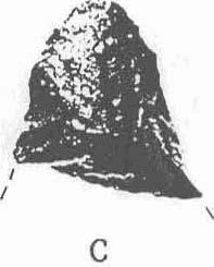
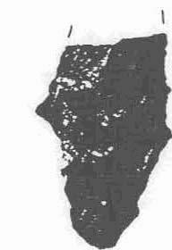
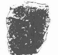
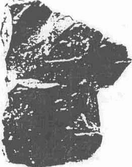
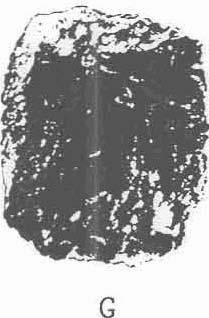
18 0 1 in. 0 2 cm Figure 4. Artifacts recovered from Site 41KF118.
19 Dart Point Base (2 specimens, Fig. 4D,E) One specimen is made of chert and is essentially rectangular in form with slightly convex edges. It is broken at the top of the stem and quite worn along this break. The second specimen is a relatively small fragment of a Gary point made of small-grained quartzite. Biface (1 specimen, Fig. 4F) Made of petrified wood this rectangular item with convex edges measures 34x2x6 mm. Core Fragment (1 specimen, Fig. 4G) The specimen is a roughly cubical block of fine-grained quartzite having cortex on one face and small flakes removed. At least portions of the surfaces appear to have been heatdamaged. Flakes (472 specimens) All are small specimens made of chert and quartzite. No further analysis is attempted. Hematite fragments (3 specimens) All are small (less than 1 cc. in volume) and of the variety known as red ocher. Burned Rocks (232 specimens) The vast majority of burned rocks were small quartzite rocks, generally less than 20 cc. in volume. A very small number of burned limestone rocks were found. These were generally smaller than the last joint of the thumb. No real concentrations were found that could be interpretedas a feature. Split Pebble (1 specimen) This is most likely a small naturally occurring piece of gravel. Burned Wood (73 specimens) Fragments of trees burned on the site during the clearing of the right-of-way. Burned Clay (1 specimen) A small lump less than 1 cc. in volume probably the result of tree burning. It is evident that Test Units 1-3 were well within the site area and that 4-6 were outside the main area of the occupation. No evidence of occupation was found on the opposite side of the road. This suggests that the portion of 41KF118 within the right-of-way is a peripheral edge. Following the comments of the land owners, it would appear that the major part of the site lies to the south southeast of the right-of-way. Also evident is that the maximum depth of cultural deposit is 30 cm in the right-of-way and that this deposit is badly disturbed by clearing, cultivation and ongoing rodent activity. No intact features were found.
20 SUMMARY AND CONCLUSIONS The site was tested to determine potential eligibility for nomination to the National Register of Historic Places (NRHP) for that portion of the site within the right-of-way. It was found that the site extended less than 20 meters along the right-of-way and was disturbed by cultivation, clearing and rodents to the depth of the sterile basal clay. No intact features were found. The age of the site is thought to correspond to Story's (1965) period 3 or LateArchaic on the basis of the small Gary point found in the excavations. No arrowpoint fragments or ceramics were found nor were any clearly Early Archaic or Paleo-lndian points or point fragments noted. Remembering the objectives previously stated, it is clear that that portion-of the site within the right-of-way does not meet the criteria for inclusion in the NRHP. It was found to have highly disturbed deposits, no intact features and limited extent. It is also evident that the great majority of the site is south of the right-of-way and appears to be less disturbed although it has been cultivated to the extent that undisturbed deposits may or may not be present.
21 REFERENCES CITED Crook, Wilson W., Jr. and R.K. Harris 1952 Trinity Aspect of the Archaic Horizon: The Carrollton and Elam Foci. Bulletin of the Texas Archaeological and Paleontological Society 23: Traits of the Trinity Aspect Archaic: Carrollton and Elam Foci. The Record 12 ( 1): Dallas Archeological Society, Dallas. Davis, W.A Archeological Survey and Appraisal of Cedar Creek Reservoir, Henderson and Kaufman Counties, Texas. Texas Archeological Salvage Project. The University of Texas at Austin. Gould, F.W Texas Plants: A Checklist and Ecological Summary. Texas Agricultural Experiment Station M.P Texas A & M University, College Station. Harris, R.K Indian Campsites of the Upper Trinity River Drainage. Bulletin of the Texas Archeological and Paleontological Society 8: Preliminary Report on an Alto Focus Site in Kaufman County. The Record 7 (4): Dallas County Archeological Society, Dallas. Hatzenbuchler, Robert C Culture Traits Ragland Site. The Record 6 (8): Dallas County Archeological Society, Dallas. Pringle, Fred B Soil Survey of Kaufman and Rockwall Counties, Texas. United States Department of Agriculture, Soil Conservation Service. Washington, D.C. Review and Compliance Staff 1985 A Bibliography of Reports: Federal Project Review. State Historic Preservation Office, Texas Historical Commission. Austin. Ross, Richard E The Upper Rockwall and Glen Hill sites, Forney Reservoir, Texas. Papers o f the Texas Archeological Salvage Project, No. 9. The University of Texas, Austin.
22 Sellards, E.H., W.S. Adkins and F.B. Plummer 1932 The Geology of Texas, Vol. I, Stratigraphy. The University of Texas Bulletin No The University of Texas. Austin. Shafer, Harry J An Appraisal of the Archeological Resources of Bardwell Reservoir, Ellis County Texas. Texas Archeological Salvage Project. The University of Texas, Austin. Sorrow, Willlam M The Pecan Springs Site, Bardwell Reservoir. Papers of the Texas Archeological Salvage Project, No. 10. The University of Texas, Austin. Stephenson, Robert L The Hogge Bridge Site and the Wylie Focus. American Antiquity 17 (4): Story, Dee Ann 1965 The Archeology of Cedar Creek Reservoir, Henderson and Kaufman Counties, Texas. Bulletin of the Texas Archeological Society 36:
AN ARCHAEOLOGICAL SURVEY FOR THE EASTHAM STATE PRISON FARM UNIT PROJECT IN HOUSTON COUNTY TEXAS
 AN ARCHAEOLOGICAL SURVEY FOR THE EASTHAM STATE PRISON FARM UNIT PROJECT IN HOUSTON COUNTY TEXAS Antiquities Permit 5693 By William E. Moore and Edward P. Baxter Brazos Valley Research Associates Contract
December 13, Kirk Shields Green Mountain Power 163 Acorn Lane Colchester, VT 05446
 December 13, 2017 Kirk Shields Green Mountain Power 163 Acorn Lane Colchester, VT 05446 RE: End of Field Letter for Archaeological Phase II Site Evaluation at Site VT-CH-1218 within the Proposed Milton
Archaeological Survey and Evaluation at 8954 El Dorado Parkway, El Cajon, San Diego County, California
 April 16, 2013 Ms. Andrea Bitterling Helix Environmental Planning, Inc. 7578 El Cajon Blvd., Suite 200 El Cajon, California 91942 Re: Archaeological Survey and Evaluation at 8954 El Dorado Parkway, El
CHAPTER 4. Blue Heron Site (47Je1001) 2003 Investigations. By Chrisie L. Hunter
 2003 Investigations. By Chrisie L. Hunter") CHAPTER 4 Blue Heron Site (47Je1001) 2003 Investigations By Chrisie L. Hunter Introduction The Blue Heron site (47Je1001) is on the property of the Crescent Bay Hunt Club, which is located in the NE 1/4
CHAPTER 4 Blue Heron Site (47Je1001) 2003 Investigations By Chrisie L. Hunter Introduction The Blue Heron site (47Je1001) is on the property of the Crescent Bay Hunt Club, which is located in the NE 1/4
THE TWO MOST SIGNIFICANT ARCHEOLOGICAL SITES IN KERR COUNTY, TEXAS ARE THE GATLIN SITE AND THE BEARING SINK HOLE SITE.
 WHAT ARE THE MOST IMPORTANT ARCHEOLOGY SITES IN KERR COUNTY? By Steve Stoutamire THE TWO MOST SIGNIFICANT ARCHEOLOGICAL SITES IN KERR COUNTY, TEXAS ARE THE GATLIN SITE AND THE BEARING SINK HOLE SITE. Map
David Moore, PacifiCorp Cultural Resources Coordinator Denise DeJoseph, Project Archaeologist
 References DeJoseph, Denise 2011 Lewis River HPMP: Swift Camp FSC Survey Negative Results. Memo report submitted by Historical Research Associates to PacifiCorp, Portland, Oregon. Copies available at PacifiCorp,
AN ARCHAEOLOGICAL SURVEY FOR THE DCP MIDSTREAM THREE RIVERS PLANT TO CGP 51 PROJECT IN LIVE OAK COUNTY, TEXAS
 AN ARCHAEOLOGICAL SURVEY FOR THE DCP MIDSTREAM THREE RIVERS PLANT TO CGP 51 PROJECT IN LIVE OAK COUNTY, TEXAS By William E. Moore Brazos Valley Research Associates Contract Report Number 251 2011 AN ARCHAEOLOGICAL
ARCHAEOLOGICAL SURVEY OF BANDERA CITY PARK, BANDERA COUNTY, TEXAS
 ARCHAEOLOGICAL SURVEY OF BANDERA CITY PARK, BANDERA COUNTY, TEXAS Ronald W. Burkett I / Center for Archaeological Research The University of Texas at San Antonio Archaeological Survey Report, No. 183 1989
Table 9. FAI accession log
 Table 9. FAI-02045 accession log UA Accession # FS # Depth (cm BS) Artifact Type n= Material Color UA2010-187-0001 1 5-10 utilized flake 1 basalt black UA2010-187-0002 2 5-10 flake 1 chert black UA2010-187-0003
Archaeological Survey and Assessment of Four Wastewater Interceptor Routes in Garner, Wake Co., N.C. (EPA C )
") Archaeological Survey and Assessment of Four Wastewater Interceptor Routes in Garner, Wake Co., N.C. (EPA C370623-02) By H. Trawick \vard R. P. Stephen Davis Prepared by the Research Laboratories of Anthropology
Archaeological Survey and Assessment of Four Wastewater Interceptor Routes in Garner, Wake Co., N.C. (EPA C370623-02) By H. Trawick \vard R. P. Stephen Davis Prepared by the Research Laboratories of Anthropology
RE: End of Field Letter for the Proposed Milton Mears Farm Road Solar Project, Milton, Chittenden County, Vermont
 October 10, 2017 Kirk Shields Green Mountain Power 163 Acorn Lane Colchester, VT 05446 RE: End of Field Letter for the Proposed Milton Mears Farm Road Solar Project, Milton, Chittenden County, Vermont
MINNESOTA DEEP TEST PROTOCOL PROJECT
 MINNESOTA DEEP TEST PROTOCOL PROJECT Mn/DOT Agreement No. 85878 OSA License No. 04-030 Authorized and Sponsored by: MINNESOTA DEPARTMENT OF TRANSPORTATION FEDERAL HIGHWAY ADMINISTRATION Prepared by COMMONWEALTH
Appendix I-1: Archaeological Records Search
 Appendix I-1: Archaeological Records Search South Central Coastal Information Center California State University, Fullerton Department of Anthropology MH-426 800 North State College Boulevard Fullerton,
ADDITIONAL PHASE IA ARCHAEOLOGICAL SURVEY FOR THE UMORE PARK SAND AND GRAVEL MINING ENVIRONMENTAL REVIEW SERVICES, DAKOTA COUNTY, MINNESOTA
 ADDITIONAL PHASE IA ARCHAEOLOGICAL SURVEY FOR THE UMORE PARK SAND AND GRAVEL MINING ENVIRONMENTAL REVIEW SERVICES, DAKOTA COUNTY, MINNESOTA ADDENDUM I Submitted to: Short Elliot Hendrickson, Inc. Submitted
PW Parkway ES Prince William County, Virginia WSSI #
 PW Parkway ES Prince William County, Virginia WSSI #15.3 Cultural Resources Site Assessment November 15 Prepared for: Prince William County Public Schools P.O. Box 39 Manassas, Virginia 1 Prepared by:
Starting at Rock Bottom: A Peculiar Central Texas PreClovis Culture
 Starting at Rock Bottom: A Peculiar Central Texas PreClovis Culture Background Brushy Creek grades, overall, west-northwest (WNW) to east-southeast (ESE) through the easternmost portions of the central
Re: Steep Slope Assessment for 2465 Waverly Drive, Blind Bay, BC; Legal Address: Lot 39, Section 18, Township 22, Range 10, Plan 25579, W6M, KDYD.
 OEL File 1563-1 May 30, 2017 Doug Wall PO Box 774 Salmon Arm, BC V1E 4N7 Re: Steep Slope Assessment for 2465 Waverly Drive, Blind Bay, BC; Legal Address: Lot 39, Section 18, Township 22, Range 10, Plan
City of Lockport Historic Resources Survey - Section METHODOLOGY
 2.0 METHODOLOGY Clinton Brown Company PN 07-008 2-1 April 2011 2.0 METHODOLOGY This methodology statement is prepared as part of the project tasks. It outlines the research sources identified, field strategies,
Prehistory and History of Squaw Creek, Powder River Basin, Wyoming
 Prehistory and History of Squaw Creek, Powder River Basin, Wyoming Mavis Greer, Ph.D. and John Greer, Ph.D. Paper Presented at the 53 rd Annual Meeting of the Wyoming Archaeological Society Cheyenne, Wyoming
Geomorphology and Archaeology: Case Studies from Western New York
 Geomorphology and Archaeology: Case Studies from Western New York New York Archaeological Council Fall Meeting Saturday October 1, 2011 Douglas J. Perrelli Geomorphology and Archaeology: Case Studies from
A Phase I Archaeological Survey of Muir Knoll, University of Wisconsin-Madison, Dane County, Wisconsin
 A Phase I Archaeological Survey of Muir Knoll, University of Wisconsin-Madison, Dane County, Wisconsin Prepared For: The University of Wisconsin-Madison Prepared By: Amy L. Rosebrough Office of the State
KANSAS GEOLOGICAL SURVEY Open File Report LAND SUBSIDENCE KIOWA COUNTY, KANSAS. May 2, 2007
 KANSAS GEOLOGICAL SURVEY Open File Report 2007-22 LAND SUBSIDENCE KIOWA COUNTY, KANSAS Prepared by Michael T. Dealy L.G., Manager, Wichita Operations SITE LOCATION The site was approximately four miles
Archaeological Monitoring of Construction of a Six-Inch Force Main Sewer over Lookout Creek, Chattanooga, Hamilton County, Tennessee
 A Report Prepared for Hamilton County Engineering Department 300 Newell Tower 117 East Seventh Street Chattanooga, Tennessee 37402 Archaeological Monitoring of Construction of a Six-Inch Force Main Sewer
Waterbury Dam Disturbance Mike Fitzgerald Devin Rowland
 Waterbury Dam Disturbance Mike Fitzgerald Devin Rowland Abstract The Waterbury Dam was completed in October 1938 as a method of flood control in the Winooski Valley. The construction began in April1935
AN ARCHAEOLOGICAL SURVEY OF THE PROPOSED VETERANS RETIREMENT HOME PROJECT IN CENTRAL SOMERVELL COUNTY, TEXAS. Texas Antiquities Permit Number 2950
 AN ARCHAEOLOGICAL SURVEY OF THE PROPOSED VETERANS RETIREMENT HOME PROJECT IN CENTRAL SOMERVELL COUNTY, TEXAS Texas Antiquities Permit Number 2950 by William E. Moore Brazos Valley Research Associates Contract
Evaluation/Monitoring Report No. 152
 Evaluation/Monitoring Report No. 152 150m west of 7 Portmore Rd. Portmore Lower Ballinderry County Antrim LICENCE NO.: AE/07/241 David McIlreavy 1 Site Specific Information Site Name Townland County :
EEEEEEE. 7 nd-a1?2 ii7 STATEMENT OF NEGATIVE FINDINGS ON THE TEST EXCAVATIONS 1;1
 7 nd-a1?2 ii7 STATEMENT OF NEGATIVE FINDINGS ON THE TEST EXCAVATIONS 1;1 AT THE REUNION SITE -- 32WA406(U) NORTH DAKOTA UNIY GRAND FORKS DEPT OF ANTHROPOLOGY AND ARCHAEOLOGY UNCLASSFIE EEEEEEE L L LOENDORF
Monitoring Report No. 022 GREENCASTLE BURIALS GREEN CASTLE COUNTY DOWN LICENCE NO. N/A PHILIP MACDONALD
 Monitoring Report No. 022 GREENCASTLE BURIALS GREEN CASTLE COUNTY DOWN LICENCE NO. N/A PHILIP MACDONALD Monitoring Report No. 022 Greencastle Burials (SMR No. Down 057:017) Greencastle Co. Down Philip
Former transport depot, Charlton Road, Charlton, Shepperton, Surrey
 Former transport depot, Charlton Road, Charlton, Shepperton, Surrey An Archaeological Evaluation for St James Homes Ltd by Steve Ford Thames Valley Archaeological Services Ltd Site Code CRC06/117 June
Evaluation/Monitoring Report No. 259
 SITE 100M EAST OF 16 LEARMORE ROAD CASTLEGORE CASTLEDERG COUNTY TYRONE LICENCE NO.: AE/13/36E NAOMI CARVER 1 Site Specific Information Site Name: 100m east of 16 Learmore Road, Castlederg, Co. Tyrone Townland:
The Rising Sun, Guildford Road, Fetcham, Surrey
 The Rising Sun, Guildford Road, Fetcham, Surrey An Archaeological Evaluation for Bovis Homes Limited by Steve Ford Thames Valley Archaeological Services Ltd Site Code RGF04/80 March 2005 Summary Site name:
Using Ground Conductivity as a Geophysical Survey Technique to Locate Potential Archaeological Sites in the Bad Axe River Valley of Western Wisconsin
 Using Ground Conductivity as a Geophysical Survey Technique to Locate Potential Archaeological Sites in the Bad Axe River Valley of Western Wisconsin Anthony J. Beauchaine, Elizabeth Werdemann Faculty
Ground Penetrating Radar Survey of a Portion of East End Cemetery, Cadiz, Kentucky
 Ground Penetrating Radar Survey of a Portion of East End Cemetery, Cadiz, Kentucky January 2011 Report prepared by Anthony L. Ortmann, Ph.D. Assistant Professor Department of Geosciences Murray State University
ENGINEER S CERTIFICATION OF FAULT AREA DEMONSTRATION (40 CFR )
") PLATTE RIVER POWER AUTHORITY RAWHIDE ENERGY STATION BOTTOM ASH TRANSFER (BAT) IMPOUNDMENTS LARIMER COUNTY, CO ENGINEER S CERTIFICATION OF FAULT AREA DEMONSTRATION (40 CFR 257.62) FOR COAL COMBUSTION RESIDUALS
PLATTE RIVER POWER AUTHORITY RAWHIDE ENERGY STATION BOTTOM ASH TRANSFER (BAT) IMPOUNDMENTS LARIMER COUNTY, CO ENGINEER S CERTIFICATION OF FAULT AREA DEMONSTRATION (40 CFR 257.62) FOR COAL COMBUSTION RESIDUALS
An Introduction to Field Explorations for Foundations
 An Introduction to Field Explorations for Foundations J. Paul Guyer, P.E., R.A. Paul Guyer is a registered mechanical engineer, civil engineer, fire protection engineer and architect with over 35 years
AN HISTORICAL AND ARCHAEOLOGICAL ASSESSMENT OF THE PROPOSED SAN ANTONIO BOTANICAL CENTER. Stephen L. Black
 AN HISTORICAL AND ARCHAEOLOGICAL ASSESSMENT OF THE PROPOSED SAN ANTONIO BOTANICAL CENTER Stephen L. Black Center for Archaeological Research The University of Texas at San Antonio Archaeological Survey
Land adjacent to 103 Pound Lane, Sonning, Berkshire
 Land adjacent to 103 Pound Lane, Sonning, Berkshire An Archaeological Evaluation for Hicks Development Ltd by James McNicoll-Norbury Thames Valley Archaeological Services Ltd Site Code PLS 09/50 June 2009
Work Conducted in August 2018
 Kelly Nieforth Economic Development Manager City of Oshkosh 215 Church Avenue Oshkosh, W 54903 August 31, 2018 RE: Update #9: August 1 to 31, 2018 Archaeological Data Recovery at the Golf Course Site (47WN0049)
Preliminary soil survey of the NATL Old Field Plots
 Preliminary soil survey of the NATL Old Field Plots The preliminary soil survey consisted of completing auger borings at 25 m intervals and included auger borings at total of 46 points. The borings were
New Mexico Register / Volume XVI, Number 15 / August 15, 2005
 TITLE 4 CHAPTER 10 PART 17 CULTURAL RESOURCES CULTURAL PROPERTIES AND HISTORIC PRESERVATION STANDARDS FOR MONITORING 4.10.17.1 ISSUING AGENCY: Cultural Properties Review Committee. Contact State Historic
COLORADO CULTURAL RESOURCE SURVEY Management Data Form Rev. 11/10
 COLORADO CULTURAL RESOURCE SURVEY OAHP1400 Rev. 11/10 A should be completed for each cultural resource recorded during an archaeological survey. Isolated finds and revisits are the exception and they do
Starting at Rock Bottom
 Starting at Rock Bottom At rock bottom of the Brushy Creek site s geological column lies the first clue to human habitation: A smelting and heattreating furnace, and mold, carved into Bed Ked: Figure 15
4.3 CULTURAL RESOURCES
 4.3 CULTURAL RESOURCES This section of the EIR analyzes the proposed project s potential impacts on archaeological and paleontological resources. This analysis summarizes the findings of the Archaeological
Prehistoric Clay Sources: A Forensic Exercise in Geoarchaeology
 Prehistoric Clay Sources: A Forensic Exercise in Geoarchaeology Lynn Ketterhagen Faculty Sponsor: Dean Wilder, Department of Geography and Earth Science ABSTRACT The prehistoric Oneota culture of the Upper
Plate 51. Site 035. Collection of remains. Scale is in cm. Plate 50. Site 034. Collection of remains. Scale is in cm
 Plate 48. Site 033. View facing north west Plate 49. Site 034. View facing north Pottery Pottery Ostrich eggshell Plate 50. Site 034. Collection of remains. Scale is in cm Plate 51. Site 035. Collection
THE CROOKS GAP HOUSEPIT SITE AND OTHER NEARBY MID-HOLOCENE HOUSEPITS
 Volume 56(1 ), Spring 2012 The Wyoming Archaeologist THE CROOKS GAP HOUSEPIT SITE AND OTHER NEARBY MID-HOLOCENE HOUSEPITS by Craig S. Smith Marcia Peterson INTRODUCTION This article summarizes excavation
This Unit is suitable for candidates with no previous archaeological experience but who have an interest in history and/or archaeology.
 National Unit specification: general information Unit code: H29B 12 Superclass: DC Publication date: August 2012 Source: Scottish Qualifications Authority Version: 01 Summary This Unit introduces candidates
SL GEOLOGY AND MINING. Coal bearing strata in the project area are referable primarily to the Allegheny Group of
 SL-145-1 GEOLOGY AND MINING Coal bearing strata in the project area are referable primarily to the Allegheny Group of Pennsylvania age. These rocks occur as dissected remnants overlying the ridge-forming
HISTORY OF CONSTRUCTION FOR EXISTING CCR SURFACE IMPOUNDMENT PLANT GASTON ASH POND 40 CFR (c)(1)(i) (xii)
(1)(i) (xii)") HISTORY OF CONSTRUCTION FOR EXISTING CCR SURFACE IMPOUNDMENT PLANT GASTON ASH POND 40 CFR 257.73(c)(1)(i) (xii) (i) Site Name and Ownership Information: Site Name: E.C. Gaston Steam Plant Site Location:
HISTORY OF CONSTRUCTION FOR EXISTING CCR SURFACE IMPOUNDMENT PLANT GASTON ASH POND 40 CFR 257.73(c)(1)(i) (xii) (i) Site Name and Ownership Information: Site Name: E.C. Gaston Steam Plant Site Location:
THE BERRYESSA CREEK SITE CA-SCL-593. Robert Cartier Richard San Filippo Archeological Resource Management 496 North Fifth Street San Jose, CA 95112
 THE BERRYESSA CREEK SITE CA-SCL-593 Robert Cartier Richard San Filippo Archeological Resource Management 496 North Fifth Street San Jose, CA 95112 ABSTRACT This presentation discusses the nature and chronology
Archaeological Investigations at the Landa Park Golf Course Pro Shop, New Braunfels, Comal County, Texas
 Archaeological Investigations at the Landa Park Golf Course Pro Shop, New Braunfels, Comal County, Texas John W. Arnn, III Robert J. Hard and C. Britt Bousman Principal Investigators Texas Antiquities
Sacred Lands File & Native American Contacts List Request
 Sacred Lands File & Native American Contacts List Request NATIVE AMERICAN HERITAGE COMMISSION 915 Capitol Mall, RM 364 Sacramento, CA 95814 (916) 653-4082 (916) 657-5390 Fax nahc@pacbell.net Information
Additional Testing for Padre Dam Eastern Service Area Secondary Connection- Alternative Site Location, San Diego County, California
 Mark Niemiec Padre Dam Municipal Water District P.O. Box 719003 9300 Fanita Parkway Santee, California 92072 Re: Additional Testing for Padre Dam Eastern Service Area Secondary Connection- Alternative
Ecoregions Glossary. 7.8B: Changes To Texas Land Earth and Space
 Ecoregions Glossary Ecoregions The term ecoregions was developed by combining the terms ecology and region. Ecology is the study of the interrelationship of organisms and their environments. The term,
Name. Designed and Produced for the Orleans County Historical Society by Andrew R. Beaupré, RPA
 Name Archaeology! Archeology! What is Archaeology? Archaeology is the scientific study of people of the past by studying the places people lived, the objects they used, and traces in the soil left by human
Groundwater Investigation SOUTHGATE GRAVEL PIT Part of Lot 15, Concession 15 (formerly Township of Proton), Township of Southgate.
, Township of Southgate.") Groundwater Investigation SOUTHGATE GRAVEL PIT Part of Lot 15, Concession 15 (formerly Township of Proton), Township of Southgate County of Grey October, 2014 Prepared for: Drysdale Aggregate Consulting
Groundwater Investigation SOUTHGATE GRAVEL PIT Part of Lot 15, Concession 15 (formerly Township of Proton), Township of Southgate County of Grey October, 2014 Prepared for: Drysdale Aggregate Consulting
Geophysical Survey. Ballymount Co. Dublin. Licence Ref. 02R029. By John Nicholls Margaret Gowen & Co. Ltd. For LRT
 Geophysical Survey Ballymount Co. Dublin Licence Ref. 02R029 By John Nicholls Margaret Gowen & Co. Ltd. For LRT 4 th April 2002 Illustrations List of Figures Figure 1 Site Location 1: 50000 Figure 2 Survey
LINGUAU DEPOSITION IN THE WOODBINE SANDS ALONG COPPERAS BRANCH, DENTON COUNTY. TEXAS: A STUDY IN MARINE SEDIMENTATION
 LINGUAU DEPOSITION IN THE WOODBINE SANDS ALONG COPPERAS BRANCH, DENTON COUNTY. TEXAS: A STUDY IN MARINE SEDIMENTATION Ellis W. Shuler and Olin M. Millican The lack of outcrops in three dimensions often
ADDITIONAL PALEO-INDIAN BIFACE VARIABILITY IN NORTHWESTERN ONTARIO. William A. Ross ABSTRACT INTRODUCTION
 ROSS: NORTHWESTERN PALEO-INDIAN BIFACES 21 ADDITIONAL PALEO-INDIAN BIFACE VARIABILITY IN NORTHWESTERN ONTARIO William A. Ross ABSTRACT Two recently recovered bifaces, which can be assigned to the Paleo-Indian
Hydrogeological Assessment for Part of Lots 2 and 3, Concession 5, Township of Thurlow, County of Hastings 1.0 INTRODUCTION. 1.
 February 10,2017 25506400 Ontario Ltd. Foxboro, ON Attention: Brad Newbatt Re: Hydrogeological Assessment for Part of Lots 2 and 3, Concession 5, Township of Thurlow, County of Hastings 1.0 INTRODUCTION
Clyde River Landslide
 Clyde River Landslide Department of Geology, Perkins Hall, University of Vermont, Burlington, VT 05405 Abstract: This paper investigates a landslide on the Clyde River in Newport, Vermont. The landslide
Big Rivers Electric Corporation Disposal of Coal Combustion Residuals (CCR) from Electric Utilities Final Rule CCR Impoundment Liner Assessment Report
 from Electric Utilities Final Rule CCR Impoundment Liner Assessment Report") Big Rivers Electric Corporation Disposal of Coal Combustion Residuals (CCR) from Electric Utilities Final Rule CCR Impoundment Liner Assessment Report CCR Surface Impoundment Information Name: Operator:
Big Rivers Electric Corporation Disposal of Coal Combustion Residuals (CCR) from Electric Utilities Final Rule CCR Impoundment Liner Assessment Report CCR Surface Impoundment Information Name: Operator:
CHAPTER FIVE THE LITHIC ASSEMBLAGES
 CHAPTER FIVE THE LITHIC ASSEMBLAGES The lithic assemblages of Tshisiku Shelter, Balerno Main Shelter and Balerno Shelter 2 provide most of the data for this study of hunter-gatherers and interaction since
4.11 CULTURAL RESOURCES
 4.11 CULTURAL RESOURCES 4.11 CULTURAL RESOURCES This section summarizes the cultural resources of. Information reviewed for the summary includes the General Plan, published reports on archaeological research
1 PROJECT BACKGROUND. August 14, Alberta Transportation Central Region #401, Street Red Deer, Alberta T4N 6K8
 August 14, 2013 Alberta Transportation Central Region #401, 4902 51 Street Red Deer, Alberta T4N 6K8 Mr. Dennis Grace, P.Eng. Construction Engineer Dear Mr. Grace: Central Region Geohazard Assessment 2013
Geophysical Survey of Wisconsin Burial Site BRO-0033 Wixom Cemetery, Rock County, Wisconsin
 Lawrence University Lux Archaeological Reports Anthropology Department 6-2015 Geophysical Survey of Wisconsin Burial Site BRO-0033 Wixom Cemetery, Rock County, Wisconsin Peter N. Peregrine Lawrence University
QUANTITY, MARCH 1962
 BASE-FLOW STUDIES, GUADALUPE RIVER COMAL COUNTY, TEXAS QUANTITY, MARCH 1962 TEXAS WATER COMMISSION BULLETIN 6503 MARCH 1965 TEXAS WATER COMMISSION Joe William D E 0. F. Dent Carter, Chairman Berger, Commissioner
Pratice Surface Processes Test
 1. The cross section below shows the movement of wind-driven sand particles that strike a partly exposed basalt cobble located at the surface of a windy desert. Which cross section best represents the
Archeological Testing and Evaluation of the Western Portion of 41CV1310, Fort Hood, Coryell County, Texas
 Inde of Teas Archaeology: Open Access Gray Literature from the Lone Star State Volume 2008 Article 17 2008 Archeological Testing and Evaluation of the Western Portion of 41CV1310, Fort Hood, Coryell County,
Former Cart Shed, Stroud Farm, Holyport, Maidenhead, Berkshire
 Former Cart Shed, Stroud Farm, Holyport, Maidenhead, Berkshire An Archaeological Watching Brief For Mr Simon Rinder by Stephen Hammond and Jennifer Lowe Thames Valley Archaeological Services Ltd Site Code
Geophysical Investigation of a 19th Century Archeological Site, Boston College K. Corcoran, J. Hager, M. Carnevale
 Geophysical Investigation of a 19th Century Archeological Site, Boston College K. Corcoran, J. Hager, M. Carnevale Hager GeoScience, Inc., Waltham, MA ------------------------------------------------------------------------
December 11, 2006 File:
 December 11, 2006 File: 15-85-38 Alberta Infrastructure and Transportation Room 301, Provincial Building 9621-96 Avenue Peace River, Alberta T8S 1T4 Attention: Mr. Ed Szmata PEACE REGION (SWAN HILLS AREA)
DEVELOPMENT REPORT. Lone I Mineral Claim Group. Wild Horse River Area Cranbrook, B.C.
 DEVELOPMENT REPORT Lone I Mineral Claim Group Wild Horse River Area Cranbrook, B.C. Fort Steele Mining District NTS 82G/12E 49 38 35 Latitude 115 38 00 Longitude LONE PEAK PLACER LTD. 514-13th Avenue South
An Evaluation of Pavement Drainage Interstate 64, Rowan-Carter Counties
 Transportation Kentucky Transportation Center Research Report University of Kentucky Year 1984 An Evaluation of Pavement Drainage Interstate 64, Rowan-Carter Counties David L. Allen Herbert F. Southgate
Historic Cultural Properties Inventory (HCPI) Base Form (FORM 1)
 Base Form (FORM 1)") Historic Cultural Properties Inventory (HCPI) Base Form (FORM 1) Historic Preservation Division, New Mexico Office of Cultural Affairs For HPD Office use only: HCPI No. District No. NRHP: SRCP: Criteria:
Historic Cultural Properties Inventory (HCPI) Base Form (FORM 1) Historic Preservation Division, New Mexico Office of Cultural Affairs For HPD Office use only: HCPI No. District No. NRHP: SRCP: Criteria:
Stratigraphy Layers of Time in the Earth by Carol Schlenk
 Subject: Science, Social Studies Grade level: 11-12 Stratigraphy Layers of Time in the Earth by Carol Schlenk Rationale: This lesson introduces students to the concept of stratification as a historical
Redgrave Pinsent Rowing Lake, Caversham Lakes, Henley Road, Caversham, Oxfordshire
 Redgrave Pinsent Rowing Lake, Caversham Lakes, Henley Road, Caversham, Oxfordshire An Archaeological Evaluation: Phase 2 for Mott McDonald Ltd by Sarah Coles and Sian Anthony Thames Valley Archaeological
APPENDIX B: REPORT ON GEOPHYSICAL SURVEY, JULY 1998
 APPENDIX B: REPORT ON GEOPHYSICAL SURVEY, JULY 1998 by Andy Payne Introduction A geophysical survey was carried out at Le Yaudet, Ploulec h, Brittany as part of the ongoing investigation into the archaeology
Lake Sedimentation Survey of Siloam Springs State Park Lake, Adams County, Illinois
 Contract Report 567 Lake Sedimentation Survey of Siloam Springs State Park Lake, Adams County, Illinois by Richard L. Allgire Office of Sediment & Wetland Studies Prepared for the Illinois Department of
The Geomorphology of the Pig Point Site (18AN50) Landform Development, Climate Change, and Long-Term Human Occupation
 Landform Development, Climate Change, and Long-Term Human Occupation") The Geomorphology of the Pig Point Site (18AN50) Landform Development, Climate Change, and Long-Term Human Occupation D O N M U L L I S T E T R A T EC H S T E P H A N I E S P E R L I N G A N N E A R U
The Geomorphology of the Pig Point Site (18AN50) Landform Development, Climate Change, and Long-Term Human Occupation D O N M U L L I S T E T R A T EC H S T E P H A N I E S P E R L I N G A N N E A R U
Opportunities to Improve Ecological Functions of Floodplains and Reduce Flood Risk along Major Rivers in the Puget Sound Basin
 Opportunities to Improve Ecological Functions of Floodplains and Reduce Flood Risk along Major Rivers in the Puget Sound Basin Christopher Konrad, US Geological Survey Tim Beechie, NOAA Fisheries Managing
Ground Penetrating Radar Survey Report: Follow-up Ground Truth Study
 Ground Penetrating Radar Survey Report: Follow-up Ground Truth Study 2005 Tell es-safi/gath Archaeological Project Figure 1: Tell es-safi GPR ground-truth study. Data Acquired August 4, 2005 Report compiled
CULTURAL HISTORY Suzzette Fig. 1. Undated Plat Map of Suzzette. Unsigned; probably drawn by J. Lee Chambers.
 CULTURAL HISTORY Suzzette by Neal McLain The map collection at the Brazoria County Historical Museum contains numerous plat maps of property subdivisions. While examining these maps, I ran across two maps
THE STRUCTURE AND THICKNESS OF THE CLINTON AND BEREA FORMATIONS IN THE VICINITY OF WOOSTER, OHIO
 THE STRUCTURE AND THICKNESS OF THE CLINTON AND BEREA FORMATIONS IN THE VICINITY OF WOOSTER, OHIO KARL VER STEEG College of Wooster INTRODUCTION AND ACKNOWLEDGMENTS The data used in the construction of
Bramley Grange, Horsham Road, Bramley, Surrey
 Bramley Grange, Horsham Road, Bramley, Surrey An Archaeological Evaluation for English Villages Housing Association by Stephen Hammond Thames Valley Archaeological Services Ltd Site Code BGB 03/95 October
Land at Larchwood Farm, Whitehorse Lane Finchampstead, Berkshire
 Land at Larchwood Farm, Whitehorse Lane Finchampstead, Berkshire An Archaeological Evaluation for Mr. John Westbrook by James McNicoll-Norbury Thames Valley Archaeological Services Ltd Site Code LFF08/103
30 Broad Street, Wokingham, Berkshire
 30 Broad Street, Wokingham, Berkshire An Archaeological Watching Brief for Psilogic Ltd by Steve Ford Thames Valley Archaeological Services Ltd Site Code 30BSW01/81 October 2001 Summary Site name: 30 Broad
DIDSBURY FLOOD STORAGE BASIN, GREATER MANCHESTER
 DIDSBURY FLOOD STORAGE BASIN, GREATER MANCHESTER Archaeological Watching Brief Report Oxford Archaeology North August 2009 Environment Agency Issue No: 2009-10/971 OA North Job No: L10130 NGR: SJ 8415
Mineral activities within Rich County, Utah
 Natural Resources and Environmental Issues Volume 14 Bear Lake Basin Article 10 1-1-2007 Mineral activities within Rich County, Utah Patsy Palacios SJ & Jessie E Quinney Natural Resources Research Library,
Phase II: Evaluation According to National Register Criteria
 Phase II: Evaluation According to National Register Criteria Introduction... 39 Determinations of Eligibility under Section 106... 40 Evaluation under State Historic Preservation Legislation... 41 Nominating
Custom Soil Resource Report for Forrest County, Mississippi
 United States Department of Agriculture Natural Resources Conservation Service A product of the National Cooperative Soil Survey, a joint effort of the United States Department of Agriculture and other
This report was prepared by Klohn Crippen Consultants Ltd. for Alberta Transportation Central Region under Contract No. CE053/2000.
 Alberta Transportation Central Region #401, 4902 51 Street Red Deer, Alberta T4N 6K8 June 7, 2002 Mr. Melvin Mayfield, P.Eng. Project Engineer Dear Mr. Mayfield: Central Region Landslide Assessment Site
ACTON COMMUNITY WIDE ARCHAEOLOGICAL RECONNAISSANCE SURVEY. Town of Acton and PAL, Inc.
 ACTON COMMUNITY WIDE ARCHAEOLOGICAL RECONNAISSANCE SURVEY Town of Acton and PAL, Inc. Objectives and Scope of Work Four phase study; (1. research, 2. draft report outline, resource protection bylaw, 3.
Results of Testing at Site 41KA87 Karnes County, Texas
 Index of Texas Archaeology: Open Access Gray Literature from the Lone Star State Volume 1988 Article 12 1988 Results of Testing at Site 41KA87 Karnes County, Texas Alan J. Wormser A. Joachim McGraw Follow
The Soils and Land Capability for Agriculture. Land North of Aberdeen, Aberdeenshire
 The Soils and Land Capability for Agriculture Of Land North of Aberdeen, Aberdeenshire Report prepared for Peter Radmall Associates May 2012 Reading Agricultural Consultants Ltd Beechwood Court, Long Toll,
Archaeological Monitoring of Land at Seacrest, Cliff Drive, Warden, Isle of Sheppey, Kent
 Archaeological Monitoring of Land at Seacrest, Cliff Drive, Warden, Isle of Sheppey, Kent Site Code SEA/WB/15 Report for Kevin & Lesley O Brian Date of report 14/10/2015 SWAT ARCHAEOLOGY Swale and Thames
Correlation of gravel deposits from trenching project on Alder Creek fluvial terrace near Point Arena, California
 Correlation of gravel deposits from trenching project on Alder Creek fluvial terrace near Point Arena, California Aletha Lee Department of Geology and Geography, West Virginia University, White Hall, Morgantown,
Thames Valley University, Kings Road, Reading, Berkshire
 Thames Valley University, Kings Road, Reading, Berkshire An Archaeological Evaluation for Thames Valley University by Danielle Milbank and Steve Ford Thames Valley Archaeological Services Ltd Site Code
AN ARCHAEOLOGICAL SURVEY FOR THE EASTHAM STATE PRISON FARM A-1 and 7-1 WELL LOCATIONS IN HOUSTON COUNTY TEXAS
 AN ARCHAEOLOGICAL SURVEY FOR THE EASTHAM STATE PRISON FARM A-1 and 7-1 WELL LOCATIONS IN HOUSTON COUNTY TEXAS Antiquities Permit 4813 By William E. Moore Brazos Valley Research Associates Contract Report
ARCHAEOLOGICAL SURVEY FOR PROPOSED LANDFILL EXPANSION (PHASE I), CITY OF DEL RIO, VAL VERDE COUNTY, TEXAS
, CITY OF DEL RIO, VAL VERDE COUNTY, TEXAS") ARCHAEOLOGICAL SURVEY FOR PROPOSED LANDFILL EXPANSION (PHASE I), CITY OF DEL RIO, VAL VERDE COUNTY, TEXAS Ronald W. Burkett Center for Archaeological Research The University of Texas at San Antonio Archaeological
ARCHAEOLOGICAL SURVEY FOR PROPOSED LANDFILL EXPANSION (PHASE I), CITY OF DEL RIO, VAL VERDE COUNTY, TEXAS Ronald W. Burkett Center for Archaeological Research The University of Texas at San Antonio Archaeological