SITE SUMMARY REPORT Candor Dump NONCD Montgomery County
|
|
|
- Stewart Gregory
- 5 years ago
- Views:
Transcription
1 SITE SUMMARY REPORT Candor Dump NONCD Montgomery County Senate Bill 1492 State of North Carolina State Contract N06009S Schnabel Project No February 23, 2010 Prepared for: North Carolina Department of Environmental and Natural Resources Superfund Section Inactive Hazardous Sites Branch 401 Oberlin Road, Suite 150 Raleigh, NC Prepared by: Schnabel Engineering South, P.C. 11-A Oak Branch Drive Greensboro, North Carolina (336) Susan A. Mickiewicz Staff Scientist/Report Author Signature Gary Rogers, L.G. Senior Associate/Reviewer Signature
2 TABLE OF CONTENTS Site Location Research Summary Areas of Note Site Summary 1.0 Site Conditions 1.1 On-site Structures 1.2 Current Site Usage 1.3 On-site Water Supply Wells and Intakes 1.4 Surface Water Features 1.5 Disposal Area 1.6 Disposal Area Conditions 1.7 Evidence of Human Activity 1.8 Potential Landfill Gas Migration Pathways 1.9 Physical Barriers 1.10 Other Pertinent Information 2.0 Vicinity Conditions 2.1 Structures Located on Adjacent Properties 2.2 Water Supply Wells and Intakes 2.3 Current Land Usage 2.4 Surface Water Features 3.0 Aerial Photography Review Table 1 Tabulated GPS Coordinates TABLES Figure 1 Figure 2 Figure 3 Figure 4 Figure 5 Appendix A Appendix B Appendix C Appendix D Appendix E FIGURES USGS Topographic Map Site Map Vicinity Map Topographic Map Overlaid On LiDAR Shaded Relief LiDAR Shaded Relief APPENDICES Field Reconnaissance Sheet Tax Records Records of Communication\Site Visit Permission Letter Site Photographs Aerial Photographs FILE: G:\2006_PROJECTS\ _(NCDENR_OLD_UNLINED_LANDFILL)\TASK_23_MONTGOMERY_CO\0433- CANDORDUMP\REPORT\FINAL\NONCD _CANDORDUMP_SITESUMMARYREPORT_ DOC
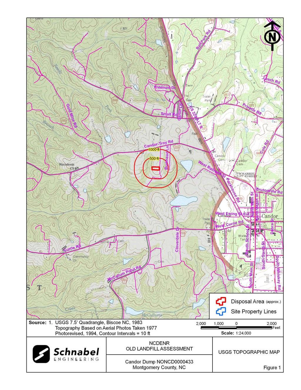
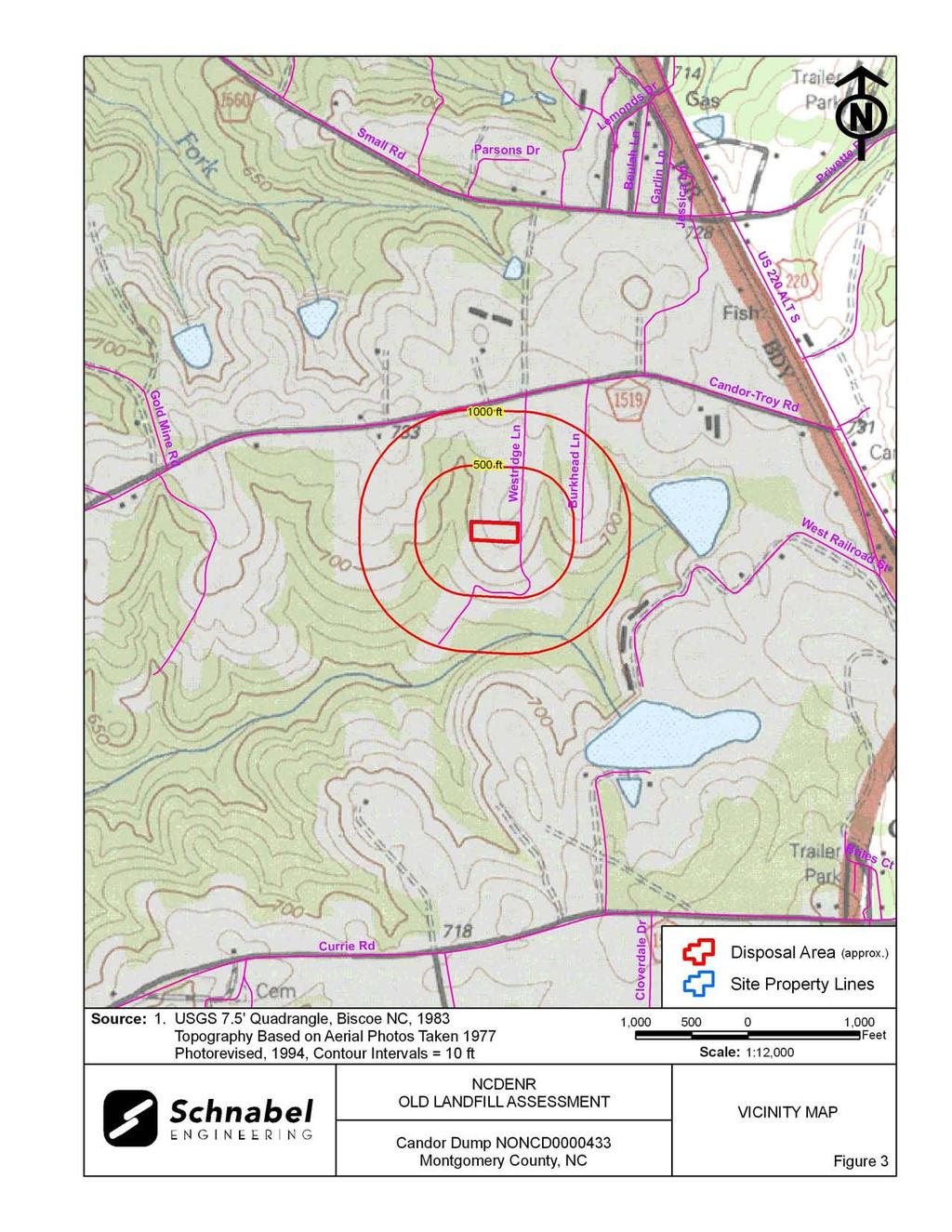
3 SITE LOCATION RESEARCH SUMMARY ID NUMBER: NONCD SITE NAME(S): Candor Dump LOCATION: Westridge Lane, Candor, NC COUNTY: Montgomery LANDFILL SIZE: PROPERTY SIZE: DATE OPENED: DATE CLOSED: 1.4 acres (Disposal Area enclosed by GPS points obtained during site visit and perimeter identified from aerial photographs) 1.4 acres (from Montgomery County GIS) Approximately 1966 (data obtained from Mr. Brice Hollis, Public Works Director for the Town of Candor) Approximately 1975 (data obtained from Mr. Brice Hollis, Public Works Director for the Town of Candor) CURRENT OWNER: Town of Candor CURRENT OWNER CONTACT: Mr. Brice Hollis, Public Works Director CURRENT OWNER ADDRESS: P.O. Box 220, Candor NC CURRENT OWNER TELEPHONE NUMBER: TAX PARCEL No./PIN No.: Parcel No DEED REFERENCE: Not Available COORDINATES: (at site entrance from on-site reading from handheld GPS) State Plane Coordinates (NAD83, meters): Northing: Easting: Latitude: N35 o Longitude: W79 o AREAS OF NOTE 1) There is evidence of human activity on the Disposal Area as indicated by surveying flags along the boundaries of the Site. 2) Residences are located within 1,000 feet of the Disposal Area and are served by public water. 3) Exposed debris consisted of tires, white goods, asphalt, roofing shingles, glass, plastic, tin, scrap metal, rusted 55-gallon drums, and insulation. 4) Hummocky topography from debris piles was observed on the central and eastern portions of the Disposal Area. A berm was observed along the western perimeter of the Disposal Area. Candor Dump NONCD
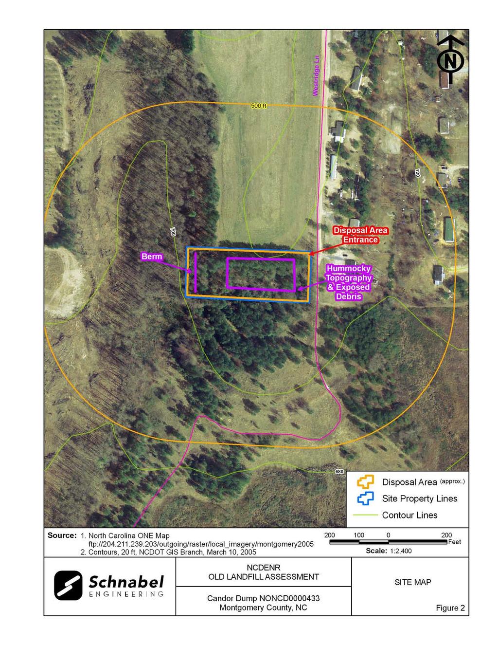
4 SITE SUMMARY 1.0 SITE CONDITIONS This section discusses the observed conditions on the Site, as defined as the property (Tax Parcel ) on which the Disposal Area is located. The Disposal Area is defined as the area observed or reported to have been used for waste placement or burial. The boundary (perimeter) of this area is the observed limit of waste material based on field observations and the inferred limit based on a review of historical aerial photographs. The site visit was conducted on February 3, Photographs illustrating site conditions are included in Appendix D. The Site is located in Montgomery County, near Candor, NC. Driving directions to the Site from the intersection of US-220 and NC Highway 24/27 are as follows: 1. Drive west on NC Highway 24/27 (East Main Street) for about 0.7 mile. 2. Turn left onto US-220 Alt (South Main Street) and drive south for approximately 4.1 miles. 3. Turn right onto Candor-Troy Road and drive for about 0.5 miles. 4. Turn left onto Westridge Lane and drive approximately 0.2 miles. The Disposal Area will be located on the right side of the road after the agricultural field. 1.1 On-site Structures No on-site buildings or other structures were observed during the site visit. 1.2 Current Site Usage According to Mr. Brice Hollis, Public Works Director for the Town of Candor, the Site is no longer used. Observed evidence of recent human activity included surveying flags along the boundaries of the Site (Photo 2). Candor Dump NONCD
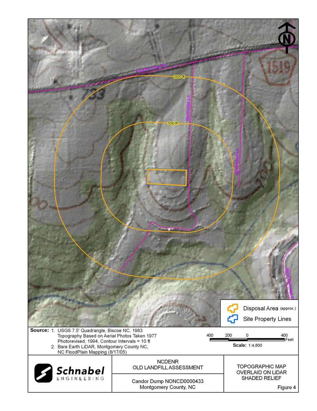
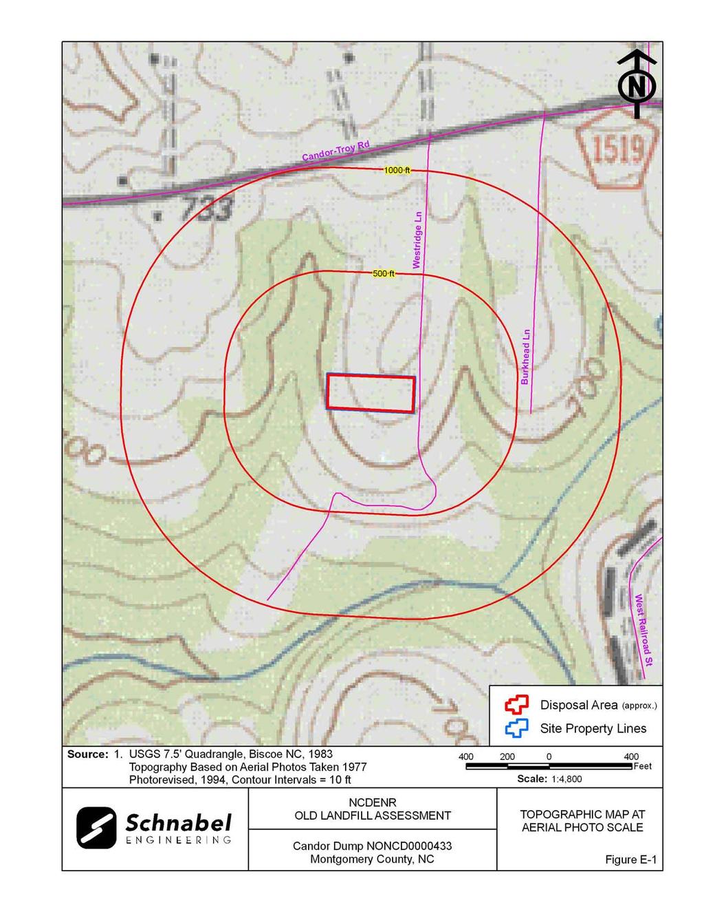
5 1.3 On-Site Water Supply Wells and Intakes No on-site water supply wells were observed on the Site during the site visit. No water meters or fire hydrants were observed on the Site during the site visit. 1.4 Surface Water Features Surface water features were not observed on the Disposal Area or the Site at the time of the site visit. 1.5 Disposal Area Access to the Disposal Area is along Westridge Lane (Photo 1). Mr. Brice Hollis, Public Works Director for the Town of Candor, accompanied Schnabel staff on the Disposal Area visit. The Disposal Area occupies 1.4 acres based on the estimated Disposal Area perimeter shown on Figures 1 through 3. The Disposal Area perimeter coincides with the boundary of the Site. The ground surface of the Disposal Area is a ridge and generally slopes toward the south. A comparison of the topography from the 1983 USGS 7.5 minute topographic quadrangle map (10 foot contours, based on 1977 aerial photography) with the 2005 topographic map from NCDOT (4 foot contours), did not show observable differences in elevation or topographic patterns. The reported years of operation were from 1966 to 1975, so the 1983 USGS map may have represented the land surface after the disposal period. LiDAR imagery (Figure 5) indicates a relatively flat area on the western portion and depressions along ridges in the central and eastern portions of the Disposal Area. Differences between elevations on the maps may reflect actual elevation changes or may be apparent differences due to the different map making methods. The elevation comparisons are approximate and differences in scale and methods of mapping are not sufficient to evaluate some changes in topography. Candor Dump NONCD
6 GPS coordinates were taken of the Disposal Area perimeter. The approximate Disposal Area perimeter is illustrated on the figures and on aerial photographs in Appendix E. A table of GPS coordinates for the Site entrance and the Site perimeter is presented in Table 1. The Disposal Area perimeter location is approximate and is based on visual observations made at the time of the site visit and interpretation of aerial photographs. Figures 4 and 5 show LiDAR shaded relief superimposed on the Disposal Area. 1.6 Disposal Area Conditions The Disposal Area was covered leaves, kudzu, brush, briars, and pine trees and deciduous trees approximately 3 inches to 8 inches in diameter. Exposed disposal material was observed in the central and eastern portions of the Disposal Area. Disposal material consisted of tires, white goods, asphalt, roofing shingles, glass, plastic, tin, scrap metal, rusted 55-gallon drums, and insulation. The observed Disposal Area was on tax parcel, Parcel Number The perimeter of the Disposal Area was visually evident. Piles of debris material covered with vegetation created hummocky topography which was observed in the central and eastern portions of the Disposal Area (Photo 4). A berm approximately 2 feet to 3 feet high extended the width of the Disposal Area near the western perimeter (Photo 7). No notable erosion, depressions, offensive odors, stained or discolored soils, or slope failures were observed during the site visit. 1.7 Evidence of Human Activity During the site visit, evidence of recent human activity consisted of surveying flags along the boundaries of the Site (Photo 2). Candor Dump NONCD
7 1.8 Potential Landfill Gas Migration Pathways There were no visible or evident potential gas migration pathways such as stormwater drain systems, underground utilities, septic systems, or drain fields observed on the Disposal Area or on the Site. 1.9 Physical Barriers Site access is along the eastern boundary of the Site on Westridge Lane. No physical barriers to the Site or Disposal Area were observed during the site visit Other Pertinent Information Some history of the Site was obtained during conversations with persons familiar with the Site. The information obtained from Mr. Brice Hollis, Public Works Director for the Town of Candor, indicates that: The Town of Candor owned and operated the site. He said local automobile companies were allowed to dispose of tires at this Site. He was not aware of any hazardous materials being disposed of at the Site. Nearby residences on Westridge Lane are supplied by public water. The Site was open during the 1960 s and 1970 s, but was not sure about approximate years of operation. He gave verbal permission to access the Site, and accompanied Schnabel personnel on the Site visit. Notes from conversations with people familiar with the site are included in Appendix C. The information obtained from these conversations has not been verified or confirmed. Candor Dump NONCD
8 2.0 VICINITY CONDITIONS This section describes the observed general conditions in the vicinity of the Site, as defined as an area within 1,000 feet of the perimeter of the Disposal Area. Photographs illustrating vicinity conditions are included in Appendix D. 2.1 Structures Located on Adjacent Properties Structures described in this section are located on adjacent properties that have a shared property boundary with the Site. A residence is located adjacent to the south of the Site on Tax Parcel A residence is located to the east of the Site on Tax Parcel An agricultural field is located to the north and a vineyard is located to the west of the Site. These structures are shown on Figure 2 and on aerial photographs in Appendix E. 2.2 Water Supply Wells and Intakes Water supply wells or well houses were not observed at residences along Westridge Lane within a 1,000-foot radius of the Disposal Area. Water meters were observed in the yards of several of the residences within 1,000 feet of the Site. Fire hydrants were observed within 1,000 feet of the Site. According to Mr. Brice Hollis, Public Works Director for the Town of Candor, the area within 1,000 feet of the Disposal Area perimeter is served by a public water supply and water lines were observed on Candor-Troy Road to the north of the Site. Candor Dump NONCD
9 2.3 Current Land Usage Property in the vicinity of the Site is primarily residential, wooded and agricultural. Land usage at the time of the site visit within 1,000 feet of the Disposal Area perimeter was: North: Agricultural field, apparent up-gradient direction from the Site. South: Residential and wooded, apparent down-gradient direction from the Site. East: Residential, apparent side- to down-gradient direction from the Site. West: Wooded, apparent side- to down-gradient direction from the Site. 2.4 Surface Water Features An unnamed perennial stream is located to the south of the Disposal Area within 1,000 feet and flows to the southwest. Candor Dump NONCD
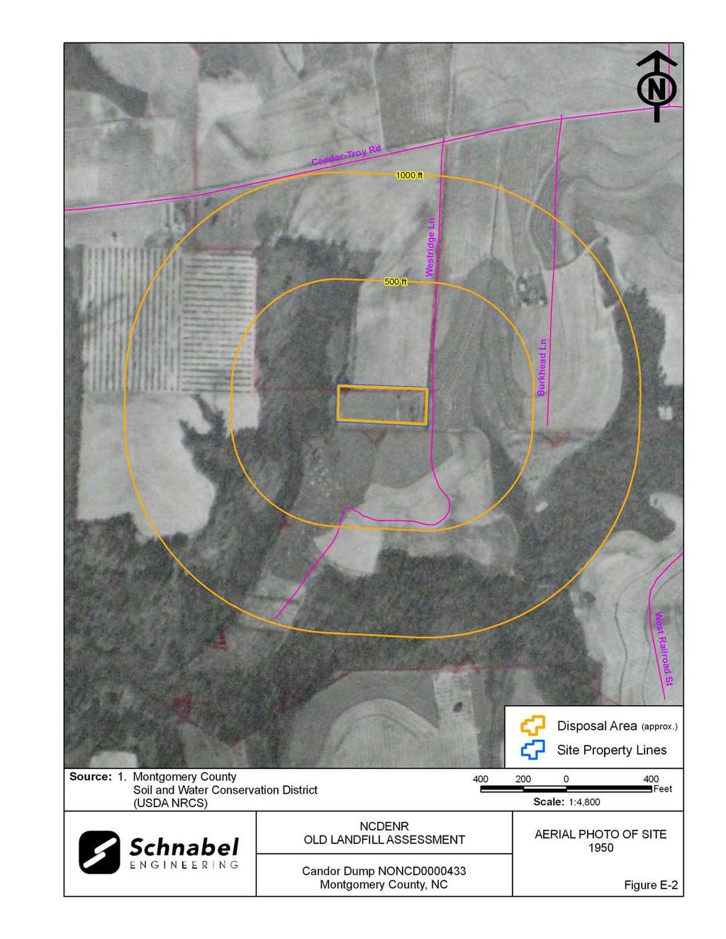
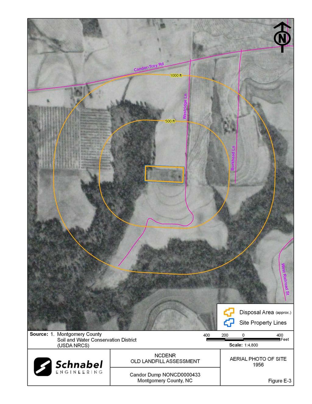
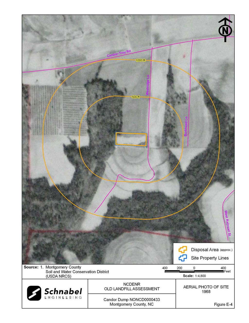
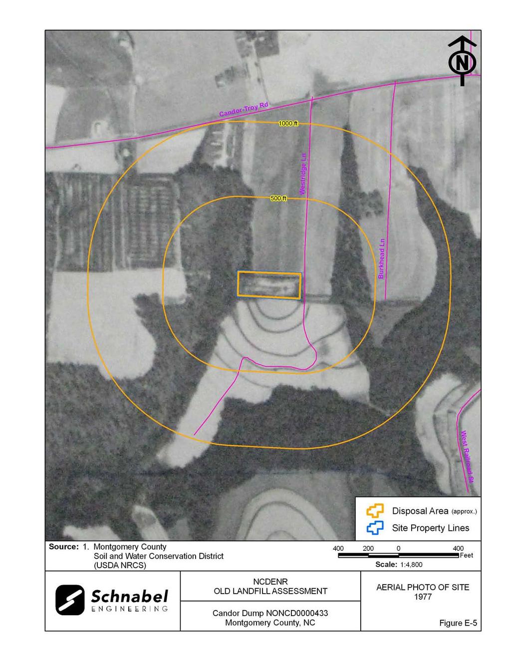
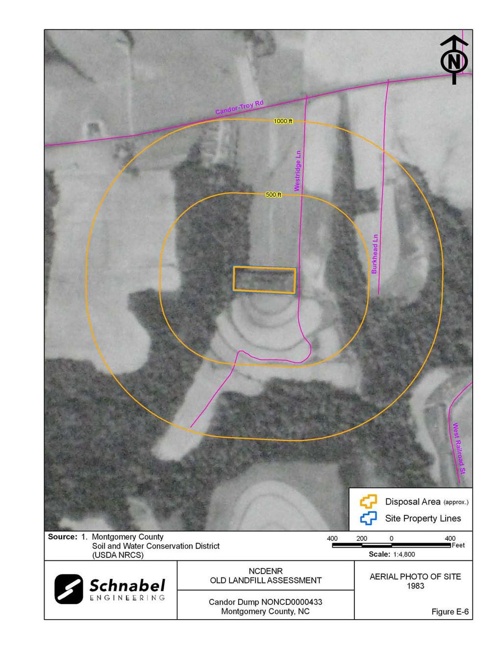
10 3.0 AERIAL PHOTOGRAPHY REVIEW Aerial photographs were reviewed for the years 1950, 1956, 1968, 1977, 1983 and The reported years of operation of the Site were from 1966 to Observations of each of the photographs are included in the following table. Copies of the aerial photographs are included in Appendix E. Some aerial photographs are reproductions of original aerial photographs and have some distortion; therefore, overlaid Disposal Area Boundaries and other features may vary from their actual locations. Flight Year Observations Source 1950 The Disposal Area and Site are covered with vegetation. 1 Candor-Troy Road is about 1,000 feet north of the Site. The Site is surrounded by agricultural fields to the north, east, and south, and a wooded area is visible to the west The Disposal Area has darker vegetation than the cleared areas 1 to the north, east, and south The Disposal Area and Site are cleared and the ground appears 1 disturbed The Disposal Area and Site are partly covered with vegetation. 1 A dirt road is visible from Candor-Troy Road to the Disposal Area. The surrounding area continues to be similar to the 1950 aerial photograph The Disposal Area and Site are wooded The Disposal Area and Site are wooded. Residences are visible along Westridge Lane to the east of the Site. Wooded areas are visible to the south of the Site. The aerial photograph shows conditions representative of those observed during the visit, except a residence is now located to the south of the Site. 2 Sources of aerial photos: 1) USDA NRCS office in Troy, NC 2) Montgomery County GIS, ftp:// /outgoing/raster/local_imagery/montgomery2005 This report was prepared specifically for the use of NCDENR Inactive Sites Branch under the Scope of Work defined in our contract dated October 26, Use of this document for other purposes or by other parties is at the sole risk of the user. Candor Dump NONCD
11 TABLE
12 Point TABLE 1 Tabulated GPS Coordinates State Plane Coordinates (meters) Latitude (deg, min, sec) Longitude (deg, min, sec) Northing Easting N W Site Entrance P P P Notes: 1) All points are on observed Disposal Area perimeter. 2) Data obtained during site visit using WAAS enabled Thales Mobile Mapper. 3) All points in NAD83 datum.
13 FIGURES
14
15
16
17
18
19 FIELD RECONNAISSANCE SHEET
20
21
22
23
24
25
26 TAX RECORDS

27 Montgomery Co., NC -- Printable Map Page 1 of 1 2/12/2010 Montgomery County, NC DISCLAIMER: The information contained on this page is NOT to be construed or used as a "legal description". Map information is believed to be accurate but accuracy is not guaranteed. Parcel No: Parcel Address: 135 ISABEL Parcel Owner: TOWN OF CANDOR PO BOX 220 CANDOR, NC Parcels Lot Number: Legal Description: Deed Reference: Bk. Pg. Land Area: 1.42A acres Year Built: Building Value: $0 Land Value: $5,112 Other Value: $0 Total Tax Value: $5,100 Sale Year: Sale Price: $0 Anderson & Associates, Inc.
28 RECORDS OF COMMUNICATION/SITE VISIT PERMISSION LETTER
29
30
31 RECORD OF CONVERSATION SITE ACCESS PERMISSION - INTERVIEW SCHNABEL STAFF: Ben Bradley DATE/TIME: February 3, 2010 INTERVIEW WITH: Mr. Brice Hollis PHONE NO.: TITLE: Public Works Director FAX NO.: ORGANIZATION: Public Works Department, Town of Candor ADDRESS: P.O. Box 220, Candor, NC PROJECT: NC DENR Old Unlined Landfill Assessments SITE NAME AND NCDENR ID NO.: Candor Dump, NONCD SUBJECT: Site Access Permission - Interview NOTES: On February 3, 2010, Ben Bradley interviewed Mr. Brice Hollis, Public Works Director for the Town of Candor, about his knowledge of the Candor Dump. Mr. Hollis was aware of the location of the Candor Dump, gave verbal permission to access the Site, and accompanied Schnabel personnel on the Site visit. Mr. Hollis stated that the Town of Candor owned and operated the site. He said local automobile companies were allowed to dispose of tires at this Site. He was not aware of any hazardous materials being disposed of at the Site. Mr. Hollis stated that the nearby residences on Westridge Lane are supplied by public water. Mr. Hollis said that the Site was open during the 1960 s and 1970 s, but was not sure about approximate years of operation. G:\2006_projects\ _(NCDENR_Old_Unlined_Landfill)\Task_23_Montgomery_Co\0433- CandorDump\Report\Final\RecOfConv-BriceHollis doc
32 SITE PHOTOGRAPHS


33 PHOTOGRAPH No.: 1 Photo Taken: LOCATION: Site entrance off of Westridge Lane. COMMENTS: Photo taken facing toward the south. Disposal Area on right side of dirt road. PHOTOGRAPH No.: 2 Photo Taken: LOCATION: Eastern perimeter of Disposal Area. COMMENTS: Photo taken facing toward the west. Surveying flags indicating the boundary of the Site. Candor Dump, NONCD


34 PHOTOGRAPH No.: 3 Photo Taken: LOCATION: Eastern portion of Disposal Area. COMMENTS: Exposed debris consisting of tires, asphalt, and roofing shingles. PHOTOGRAPH No.: 4 Photo Taken: LOCATION: Central part of Disposal Area. COMMENTS: Briars and kudzu cover piles of tires and roofing shingles. Piles of debris create a hummocky topography on the Disposal Area. Candor Dump, NONCD


35 PHOTOGRAPH No.: 5 Photo Taken: LOCATION: Central part of Disposal Area. COMMENTS: Insulation, white goods, and scrap metal. PHOTOGRAPH No.: 6 Photo Taken: LOCATION: Western part of Disposal Area. COMMENTS: Rusted 55-gallon drums with glass, plastic, and tin debris, and exposed scrap metal. Candor Dump, NONCD

36 PHOTOGRAPH No.: 7 Photo Taken: LOCATION: Western perimeter of Disposal Area. COMMENTS: Photo taken facing toward the south. Berm approximately 2 feet to 3 feet high extending the width of the Disposal Area. Candor Dump, NONCD
37 AERIAL PHOTOGRAPHS
38
39
40
41
42
43

44
PW Parkway ES Prince William County, Virginia WSSI #
 PW Parkway ES Prince William County, Virginia WSSI #15.3 Cultural Resources Site Assessment November 15 Prepared for: Prince William County Public Schools P.O. Box 39 Manassas, Virginia 1 Prepared by:
Site Summary Report GOLDSTON DUMP ID NUMBER: NONCD Chatham County, North Carolina
 Site Summary Report GOLDSTON DUMP ID NUMBER: NONCD0000227 Chatham County, North Carolina Senate Bill 1492 State of North Carolina State Contract N06010S MM&A Project Number NCUL145 Prepared For: North
Butte County Fire Department
 Butte County Fire Department Basic Land Navigation Verification Sheet I verify that Print Supervisor s name has completed the Print Employee s name Basic Land Navigation self study guide on. Date Attached
Big Rivers Electric Corporation Disposal of Coal Combustion Residuals (CCR) from Electric Utilities Final Rule CCR Impoundment Liner Assessment Report
 from Electric Utilities Final Rule CCR Impoundment Liner Assessment Report") Big Rivers Electric Corporation Disposal of Coal Combustion Residuals (CCR) from Electric Utilities Final Rule CCR Impoundment Liner Assessment Report CCR Surface Impoundment Information Name: Operator:
Big Rivers Electric Corporation Disposal of Coal Combustion Residuals (CCR) from Electric Utilities Final Rule CCR Impoundment Liner Assessment Report CCR Surface Impoundment Information Name: Operator:
Lecture 9: Reference Maps & Aerial Photography
 Lecture 9: Reference Maps & Aerial Photography I. Overview of Reference and Topographic Maps There are two basic types of maps? Reference Maps - General purpose maps & Thematic Maps - maps made for a specific
GIS SERVICE CENTER MAP ORDER FORM
 Steven V. Stenger County Executive Pam Reitz Director of Administration GIS SERVICE CENTER MAP ORDER FORM 1. Print this form. 2. Fill out the form calculate and include the total cost of your order. 3.
Road Scholar. Coaches Clinic
 Coaches Clinic Test Format Review of Individual Test Elements Items to Bring Tips Links General Test Format: Storyline Test Navigation Elements Identification of Landmarks, features, etc. Aerial/Satellite
Chapter 1 Overview of Maps
 Chapter 1 Overview of Maps In this chapter you will learn about: Key points when working with maps General types of maps Incident specific maps Map legend and symbols Map sources A map is a navigational
Advanced Geologic Exploration, Inc.
 Advanced Geologic Exploration, Inc. Scientists of the Earth PO Box 1956, Chester, CA 96020 Voice: (530) 258-4228 Fax (530) 258-4339 www.advancedgeologic.com January 23, 2009 Job No. G-081201 Terri Barber,
APPLICATION FOR CONDITIONAL ABSOLUTE WATER STORAGE RIGHT
 District Court, Water Division, Colorado Court Address: CONCERNING THE APPLICATION FOR WATER RIGHTS OF Applicant: In the River or its Tributaries In COUNTY Attorney or Party Without Attorney (Name and
Butte County Fire Department
 Butte County Fire Department Basic Land Navigation Verification Sheet I verify that Print Supervisor's name Print Employee's name has completed the Basic Land Navigation self study guide on Date Attached
DRAFT. PRELIMINARY LANDSLIDE MODELING for KRAMER AVENUE LANDSLIDE SITKA, ALASKA. Prepared for: Andrew Friske 210 Kramer Ave. Sitka, Alaska 99835
 PRELIMINARY LANDSLIDE MODELING for KRAMER AVENUE LANDSLIDE SITKA, ALASKA Prepared for: Andrew Friske 210 Kramer Ave. Sitka, Alaska 99835 Prepared by: Northern Geotechnical Engineering, Inc. d.b.a. Terra
Woodford County Erosion Prevention Plan and Permit. Application #
 Woodford County Erosion Prevention Plan and Permit Application # Date Instructions: Applicant will complete Parts A and B, and attach a proposed site diagram. This diagram must be completed in accordance
Geographic Information Systems. Introduction to Data and Data Sources
 Geographic Information Systems Introduction to Data and Data Sources Presented by John Showler, NJDA-SSCC NJ SCD GIS Training Session December 10, 209 The Objectives of this session are 3-fold: 1. Introduce
Aerial Photography and Imagery Resources Guide
 Aerial Photography and Imagery Resources Guide Cheyenne and Laramie County Cooperative GIS Created and Maintained by the GIS Coordinator for the Cooperative GIS Program March 2011 CHEYENNE / LARAMIE COUNTY
Cripps Ranch 76+/- Acres Orchard Development Opportunity Dixon, CA. Presented By:
 Cripps Ranch 76+/- Acres Orchard Development Opportunity Dixon, CA Presented By: Cripps Ranch 76+/- Acres Orchard Development Opportunity Dixon, CA Location: This property is located at 5663 Dally Road
Aerial Photography and Imagery Resources Guide
 Aerial Photography and Imagery Resources Guide Cheyenne and Laramie County Cooperative GIS Created and Maintained by the GIS Coordinator for the Cooperative GIS Program May 2016 CHEYENNE / LARAMIE COUNTY
AGENDA CLAYTON BOARD OF ADJUSTMENT
 AGENDA CLAYTON BOARD OF ADJUSTMENT APRIL 15, 2015 6:00 P.M. CLAYTON TOWN HALL 111 East Second Street, Clayton NC I. ROLL CALL II. III. IV. ANNOUNCEMENT OF QUORUM / VOTING MEMBERS ADJUSTMENTS TO AGENDA
GEOSYNTEC CONSULTANTS
 GEOSYNTEC CONSULTANTS 2100 Main Street, Suite 150 Huntington Beach, CA 92648 USA Tel (714) 969-0800 Fax (714) 969-0820 15 February 2006 Ms. Tamara Zeier, P.E. Project Manager Project Navigator, Ltd. One
Name of Applicant Mailing Address address Telephone Number
 District Court, Water Division, Colorado Court Address: CONCERNING THE APPLICATION FOR WATER RIGHTS OF Applicant: In the River or its Tributaries In COUNTY Attorney or Party Without Attorney (Name and
ENGINEERING EVALUATION OF THE STANLEY MINE ADVENTURE PARK AREA CLEAR CREEK COUNTY, COLORADO. Prepared for:
 braun Braun Consulting Engineers ENGINEERING EVALUATION OF THE STANLEY MINE ADVENTURE PARK AREA CLEAR CREEK COUNTY, COLORADO Prepared for: STANLEY MINES ADENTURE PARK 3375 W. POWERS CIRCLE LITTLETON, COLORADO
Mapping Earth. How are Earth s surface features measured and modeled?
 Name Mapping Earth How are Earth s surface features measured and modeled? Before You Read Before you read the chapter, think about what you know about maps Record your thoughts in the first column Pair
What is a map? A Map is a two or three-dimensional model or representation of the Earth s surface. 2-Dimensional map
 What is a map? A Map is a two or three-dimensional model or representation of the Earth s surface. 2-Dimensional map What is a Map Projection? Planar Projection Projection A Projection is a mathematical
Gateway Trail Project
 Gateway Trail Project Debris Flow Hazard Assessment By: Juan de la Fuente April 30, 2010 Background- On April 22, 2010, the Shasta-Trinity National Forest (Mt. Shasta-McCloud Unit) requested a geologic
Development of Improved Stream Mapping for NC
 Development of Improved Stream Mapping for NC Presentation for Soil Science Society of North Carolina NC Division of Water Quality January 21, 2009 What are stream maps used for? Riparian buffer rules
1.1 What is Site Fingerprinting?
 Site Fingerprinting Utilizing GIS/GPS Technology 1.1 What is Site Fingerprinting? Site fingerprinting is a planning tool used to design communities where protection of natural resources is the primary
APPLICATION TO AMEND THE FUTURE LAND USE MAP (FLUM) SMALL SCALE
 SMALL SCALE") DEPARTMENT OF DEVELOPMENT & PLANNING 825 Ohio Avenue - Lynn Haven, FL 32444 (850) 265-2961 - (850) 265-3478 APPLICATION TO AMEND THE FUTURE LAND USE MAP (FLUM) SMALL SCALE Deadline to submit is 30 days
DEPARTMENT OF DEVELOPMENT & PLANNING 825 Ohio Avenue - Lynn Haven, FL 32444 (850) 265-2961 - (850) 265-3478 APPLICATION TO AMEND THE FUTURE LAND USE MAP (FLUM) SMALL SCALE Deadline to submit is 30 days
Sacred Lands File & Native American Contacts List Request
 Sacred Lands File & Native American Contacts List Request NATIVE AMERICAN HERITAGE COMMISSION 915 Capitol Mall, RM 364 Sacramento, CA 95814 (916) 653-4082 (916) 657-5390 Fax nahc@pacbell.net Information
May 22, Mr. Tim Tyler TRWME Properties, LLC 240 Hwy. 65 N Conway, AR RE: Royal Oaks Vista Subdivision Site. Dear Mr.
 May 22, 2008 Mr. Tim Tyler TRWME Properties, LLC 240 Hwy. 65 N Conway, AR 72032 RE: Royal Oaks Vista Subdivision Site AFIN: 12-00272 NPDES Permit No.: ARR150472 Dear Mr. Tyler: On March 26, 2008, I performed
Remote Sensing the Urban Landscape
 Remote Sensing the Urban Landscape Urban landscape are composed of a diverse assemblage of materials (concrete, asphalt, metal, plastic, shingles, glass, water, grass, shrubbery, trees, and soil) arranged
MVP WMS, George Schorr
 APPROVED JURISDICTIONAL DETERMINATION FORM U.S. Army Corps of Engineers This form should be completed by following the instructions provided in Section IV of the JD Form Instructional Guidebook. SECTION
LOCATED IN INDIAN RIVER COUNTY PREPARED FOR S.J.R.W.M.D. AND F.W.C.D. DECEMBER, 2003 Updated 2007 Updated May 2014 PREPARED BY
 FELLSMERE WATER CONTROL DISTRICT EAST MASTER DRAINAGE PLAN AND STORMWATER HYDROLOGIC ANALYSIS OF THE GRAVITY DRAINAGE SYSTEM LOCATED BETWEEN THE EAST BOUNDARY, LATERAL U, THE MAIN CANAL, AND DITCH 24 LOCATED
SHADOW STUDY REPORT REGARDING
 SHADOW STUDY REPORT REGARDING an APPLICATION TO REDEVELOP Three 6 Storey Condominiums Regional Road 25 (Ontario Street) and Britannia Road Milton, Ontario KNYMH FILE # 17030 Prepared by: Krista Lilley
APPLICATION FOR CHANGE OF WATER RIGHT
 District Court, Water Division, Colorado Court Address: CONCERNING THE APPLICATION FOR WATER RIGHTS OF Applicant: In the River or its Tributaries In COUNTY COURT USE ONLY Attorney or Party Without Attorney
Lab Topographic Maps. Name: Partner: Purpose. Background Information
 Lab Topographic Maps Name: Partner: Purpose The purpose of this lab is to familiarize you with graphic representations of the Earth s surface primarily maps. Simple line maps show the spatial relationship
8 th 12 th Designing a Monitoring Plan Mapping & Analysis (Activities 1 2)
") 8 th 12 th Designing a Monitoring Plan Mapping & Analysis (Activities 1 2) Objectives for All Activities - To be able to define and describe the purpose and uses of topographic maps. - To define rules
8 th 12 th Designing a Monitoring Plan Mapping & Analysis (Activities 1 2) Objectives for All Activities - To be able to define and describe the purpose and uses of topographic maps. - To define rules
CASE STUDIES. Introduction
 Introduction The City of Winston-Salem faces the challenge of maintaining public infrastructure (e.g., water and sewer lines, storm drains, roads, culverts and bridges) while minimizing the potential impacts
APPENDIX E GREATER SPRINGFIELD RELIABILTIY PROJECT DRAINAGE ANALYSIS FOR THE NEWGATE/PHELPS ROAD AND THE HATCHETT HILL ROAD AREAS
 APPENDIX E GREATER SPRINGFIELD RELIABILTIY PROJECT DRAINAGE ANALYSIS FOR THE NEWGATE/PHELPS ROAD AND THE HATCHETT HILL ROAD AREAS New England East-West Solution (NEEWS) Greater Springfield Reliability
Map Reading 101: Using and Reading Maps and Plans
 Map Reading 101: Using and Reading Maps and Plans A Key Skill for Land Use Commissioners Paula Stahl, LLA, ASLA, AICP Land Use Educator Green Valley Institute Land Use Academy 1 How most of us react to
What Do You See? FOR 274: Forest Measurements and Inventory. Area Determination: Frequency and Cover
 What Do You See? Message of the Day: Many options exist to determine the size, area, or extent of a feature on a landscape FOR 274: Forest Measurements and Inventory Lecture 7: Measures of Land Area Frequency
Quick Response Report #126 Hurricane Floyd Flood Mapping Integrating Landsat 7 TM Satellite Imagery and DEM Data
 Quick Response Report #126 Hurricane Floyd Flood Mapping Integrating Landsat 7 TM Satellite Imagery and DEM Data Jeffrey D. Colby Yong Wang Karen Mulcahy Department of Geography East Carolina University
UPPER COSUMNES RIVER FLOOD MAPPING
 UPPER COSUMNES RIVER FLOOD MAPPING DRAFT BASIC DATA NARRATIVE FLOOD INSURANCE STUDY SACRAMENTO COUTY, CALIFORNIA Community No. 060262 November 2008 Prepared By: CIVIL ENGINEERING SOLUTIONS, INC. 1325 Howe
FOR SALE. Features Rives Road Petersburg, Virginia Chris Jenkins
 FOR SALE 3513 Rives Road Petersburg, Virginia 23805 Chris Jenkins T 804-228-4928 E cjenkins@ commonwealthcommercial.com Bill Barnett T 804-433-1821 E bbarnett@ commonwealthcommercial.com Features 142±
Illustrator: Vector base Each line/point store some sort of information Mapping Representation of the world
 Illustrator: Vector base Each line/point store some sort of information Mapping Representation of the world Photoshop Raster base Images can be overlaid Pixel vector data model: [data models] A representation
GIS APPLICATIONS IN SOIL SURVEY UPDATES
 GIS APPLICATIONS IN SOIL SURVEY UPDATES ABSTRACT Recent computer hardware and GIS software developments provide new methods that can be used to update existing digital soil surveys. Multi-perspective visualization
Villages at Riverdale Thornton, CO
 FINAL UTILITY REPORT Villages at Riverdale Thornton, CO October 14, 216 Revised: March 29, 217 JN: 1539 Prepared for: PCS Group, Inc. 11 16 th Street #3 B-18 Denver, CO 8265 P: 33.531.495 Prepared by:
Chapter 1 Homework - Elements of Real Estate Law
 Chapter 1 Homework - Elements of Real Estate Law The following questions are a small example of what you might expect to see on the Real Estate Law portion of the Cadastral Mapping exam. First try answering
APPLICATION FOR SIMPLE CHANGE IN SURFACE POINT OF DIVERSION PURSUANT TO (3.5), C.R.S.
, C.R.S.") District Court, Water Division, Colorado Court Address: CONCERNING THE APPLICATION FOR WATER RIGHTS OF Applicant: In the River or its Tributaries In COUNTY COURT USE ONLY Attorney or Party Without Attorney
District Court, Water Division, Colorado Court Address: CONCERNING THE APPLICATION FOR WATER RIGHTS OF Applicant: In the River or its Tributaries In COUNTY COURT USE ONLY Attorney or Party Without Attorney
UTILITY REPORT FOR THORNTON SELF STORAGE THORNTON, COLORADO
 UTILITY REPORT FOR THORNTON SELF STORAGE THORNTON, COLORADO Prepared by: Bowman Consulting 63 Park Point Dr. Suite 1 Golden, CO 841 (33)-81-29 June 29, 215 Revised August 14, 215 Revised September 3, 215
NAME DATE TOPOGRAPHIC MAPS. Activity 1: Topographic Map Investigation I: More Than a Road Map
 NAME DATE PARTNER(S) TOPOGRAPHIC MAPS Now you have seen how topographic maps can be generated to present the elevation of a terrain. Let s look at some topographic maps and learn how to interpret them.
 Boone County GIS has the right to inquire about and investigate the use of any requested products and deny access to anyone based on concerns relating to privacy, security, public health, public safety,
EXHIBIT H LOT 317 GRADING AND SITE PLAN
 EXHIBIT H LOT 317 GRADING AND SITE PLAN EXHIBIT I LOT 317 ELEVATIONS ridge height 4915'-6" GENERAL & KEYED NOTES ridge height 4905'-9" 3 7 4 A5.1 1 5 ridge height 4910'-6" 2 ridge height 4906'-3" 1 Provide
McHenry County Property Search Sources of Information
 Disclaimer: The information in this system may contain inaccuracies or typographical errors. The information in this system is a digital representation of information derived from original documents; as
Schuyler County Idle Farmland Analysis. Conducted by Cornell Cooperative Extension of Schuyler County
 Schuyler County Idle Farmland Analysis Conducted by Cornell Cooperative Extension of Schuyler County June 15, 2010 Schuyler County Idle Farmland Analysis Purpose: The purpose of this analysis is to approximate
Minimum Standards for Wetland Delineations
 Minimum Standards for Wetland Delineations Jason Gipson Chief, Utah/Nevada Regulatory Branch Sacramento District Regulatory Program Workshop 16 Mar 2016 US Army Corps of Engineers Delineation Report Minimum
King County Explorer Search and Rescue. Course B Map & Compass
 King County Explorer Search and Rescue Course B Map & Compass Disclaimer The intent of this presentation is to provide a basic overview of maps, compasses, and location finding. It is not meant to be a
Hydrogeological Assessment for Part of Lots 2 and 3, Concession 5, Township of Thurlow, County of Hastings 1.0 INTRODUCTION. 1.
 February 10,2017 25506400 Ontario Ltd. Foxboro, ON Attention: Brad Newbatt Re: Hydrogeological Assessment for Part of Lots 2 and 3, Concession 5, Township of Thurlow, County of Hastings 1.0 INTRODUCTION
APPENDIX F PRE-COURSE WORK
 APPENDIX F PRE-COURSE WORK F-1 Pre-Course Work F-2 Pre-Course Work Intermediate Wildland Fire Behavior, S-290 Pre-Course Work The pre-course work is designed to ensure that students come to class with
CULTURAL HISTORY Suzzette Fig. 1. Undated Plat Map of Suzzette. Unsigned; probably drawn by J. Lee Chambers.
 CULTURAL HISTORY Suzzette by Neal McLain The map collection at the Brazoria County Historical Museum contains numerous plat maps of property subdivisions. While examining these maps, I ran across two maps
Sierra-Crete Task Force
 to the Contra Costa County Sierra-Crete Task Force Informational Open House and Community Meeting CONTRA COSTA COUNTY SIERRA-C -CRETE TASKASK FORCE To further evaluate and verify the information provided
HISTORY OF CONSTRUCTION FOR EXISTING CCR SURFACE IMPOUNDMENT PLANT GASTON ASH POND 40 CFR (c)(1)(i) (xii)
(1)(i) (xii)") HISTORY OF CONSTRUCTION FOR EXISTING CCR SURFACE IMPOUNDMENT PLANT GASTON ASH POND 40 CFR 257.73(c)(1)(i) (xii) (i) Site Name and Ownership Information: Site Name: E.C. Gaston Steam Plant Site Location:
HISTORY OF CONSTRUCTION FOR EXISTING CCR SURFACE IMPOUNDMENT PLANT GASTON ASH POND 40 CFR 257.73(c)(1)(i) (xii) (i) Site Name and Ownership Information: Site Name: E.C. Gaston Steam Plant Site Location:
APPROVED JURISDICTIONAL DETERMINATION FORM U.S. Army Corps of Engineers
 APPROVED JURISDICTIONAL DETERMINATION FORM U.S. Army Corps of Engineers This form should be completed by following the instructions provided in Section IV of the JD Form Instructional Guidebook. SECTION
CHAPTER GEOLOGICALLY HAZARDOUS AREAS Applicability Regulations.
 CHAPTER 19.07 GEOLOGICALLY HAZARDOUS AREAS 19.07.010 Applicability. Geologically hazardous areas may pose a threat to the health and safety of citizens when incompatible development is sited in areas of
CALIFORNIA AGRICULTURAL PR OPERTIES, IN C. GALE RANCH
 CALIFORNIA AGRICULTURAL PR OPERTIES, IN C. GALE RANCH LOCATION: The Ranch is located 6 Yi miles west of the City of Davis on the northwest corner of County Roads 29A and 92E in Yolo County. SIZE: 368.64
Using Map and Compass Together
 Using Map and Compass Together In situations where you foresee a potential evacuation on foot, where there are no roads, and no indication as to the direction of travel (i.e., road signs), it is recommended
UNIT 1C. USING TOPOGRAPHIC MAPS WHERE IN THE WORLD... ARE YOU?
 UNIT 1C. USING TOPOGRAPHIC MAPS WHERE IN THE WORLD... ARE YOU? TIME 60-90 minutes LEVEL All BENCHMARKS Next Generation Science Standards MS-LS1.D Science & Engineering Practices Developing and Using Models
REQUEST FOR PROPOSALS CLOSING DATE:
 Request for Proposals 110 Westlake Drive City of West Lake Hills 110 Westlake Drive REQUEST FOR PROPOSALS CLOSING DATE: Tuesday, October 23, 2018 City of West Lake Hills Request for Proposals 1 I. INTRODUCTION
For Sale - 56 Acre Sandstone Quarry State Route 511, Oberlin/Kipton, OH 44075
 14647 State Route 511, Oberlin/Kipton, OH 44075 56 ACRES Vermilion Rd Gifford Rd Haigh Rd 44 Summary The Kipton sandstone quarry is included in 56 acre tract owned by Terry A. Johnson, of Huron, Ohio.
Mapping the Badlands. Surveying and GIS Just Got Easier. >> By Deral Paulk, LS
 $4.95 Mapping the Badlands Surveying and GIS Just Got Easier Surveying and mapping here in southwestern Oklahoma can be a challenge. It s a rough-hewn landscape with rugged terrain features and plenty
Activities: Map and Compass
 Activities: Map and Compass Determining General Directions Modified with permission from Outdoor Living Skills Series: Map and Compass, Missouri Department of Conservation Overview: Students use the sun
Name Date Class. Original content Copyright by Holt McDougal. Additions and changes to the original content are the responsibility of the instructor.
 Name Date Class 1-1 Graphing Linear Equations Write the correct answer. 1. The distance in feet traveled by a falling object is found by the formula d = 16t where d is the distance in feet and t is the
Appendix E Guidance for Shallow Flooding Analyses and Mapping
 Appendix E Guidance for Shallow Flooding Analyses and Mapping E.1 Introduction Different types of shallow flooding commonly occur throughout the United States. Types of flows that result in shallow flooding
Chapter 02 Maps. Multiple Choice Questions
 Chapter 02 Maps Multiple Choice Questions 1. Every projection has some degree of distortion because A. a curved surface cannot be represented on a flat surface without distortion. B. parallels and meridians
VIKING INSPECTION PROPERTY 4921 U.S. Hwy. 85, Williston, ND 58801
 SALE PRICE: $799,000 LOT SIZE: +/-2.49 Acres BUILDING SIZE: +/-3,800 SF DRIVE-IN DOORS 2 CEILING HEIGHT: 16' YEAR BUILT: 2007 ZONING: Commercial PROPERTY OVERVIEW Highly visible, hard-to-find small shop/office/apartment
TREASURE COAST REGIONAL PLANNING COUNCIL M E M O R A N D U M. To: Council Members AGENDA ITEM 4B10
 TREASURE COAST REGIONAL PLANNING COUNCIL M E M O R A N D U M To: Council Members AGENDA ITEM 4B10 From: Date: Subject: Staff December 14, 2018 Council Meeting Local Government Comprehensive Plan Review
Unit 1, Lesson 3 What Tools and Technologies Do Geographers Use?
 Unit 1, Lesson 3 What Tools and Technologies Do Geographers Use? Geographers use a variety of tools and technologies in investigating geographic questions. Maps and globes both represent the earth, but
Florida Department of Environmental Protection Inspection Checklist N. SIDE OF HWY. 20-W.OF FREEPT
 Florida Department of Environmental Protection Inspection Checklist FACILITY INFORMATION: Facility Name: On-Site Inspection Start Date: On-Site Inspection End Date: 10/08/2015 WACS No.: 15091 Facility
February 18, 2003 File: NORTH CENTRAL REGION LANDSLIDE ASSESSMENT HWY 43:16 WHITECOURT EAST HILL (NC1) 2002 ANNUAL INSPECTION REPORT
 2002 ANNUAL INSPECTION REPORT") February 18, 2003 File: 15-76-11 Alberta Transportation Room 223, Provincial Building 4709 44 Avenue Stony Plain, Alberta T7Z 1N4 Attention: Mr. Rob Lonson, P.Eng. NORTH CENTRAL REGION LANDSLIDE ASSESSMENT
February 18, 2003 File: 15-76-11 Alberta Transportation Room 223, Provincial Building 4709 44 Avenue Stony Plain, Alberta T7Z 1N4 Attention: Mr. Rob Lonson, P.Eng. NORTH CENTRAL REGION LANDSLIDE ASSESSMENT
Esri Image & Mapping Forum 9 July 2017 Geiger-Mode for Conservation Planning & Design by USDA NRCS NGCE
 Esri Image & Mapping Forum 9 July 2017 Geiger-Mode for Conservation Planning & Design by USDA NRCS NGCE For over 75 years, the Natural Resources Conservation Service has been a pioneer in conservation,
Introduction to maps
 Introduction to maps What is a map? A generalized view of an area, usually some portion of Earth s surface, as seen from above at a greatly reduced size Any geographical image of the environment A two-dimensional
Integrating LiDAR data into the workflow of cartographic representation.
 Integrating LiDAR data into the workflow of cartographic representation. Cartographic Workflow I. 1 2 3 4 5 Surveying Vector (Nat. GDB) GPS, Laser Range Finder Yes/ No Scanning old maps LiDARflights Capture
Plan for Identification of New Discharges September 2014 Roxboro Steam Electric Plant TABLE OF CONTENTS
 Plan for Identification of New Discharges September 2014 Roxboro Steam Electric Plant SECTION TABLE OF CONTENTS PAGE 1.0 Introduction... 1 2.0 Site Description... 3 2.1 Plant Description... 3 2.2 Ash Basin
Carrick Road $798,000
 1955-2020 Carrick Road 165.76± acres Fayette/Scott Counties $798,000 Offered Exclusively By: Zach Davis Principal Broker +1.859.576.8195 www.kirkfarms.com zach@kirkfarms.com Measuring an appx. 165+/- acres,
Coyote Creek Apache County, Arizona
 Coyote Creek Apache County, Arizona Listed for sale exclusively by: Traegen Knight Headquarters West Ltd. PO BOX 1980 St. Johns, AZ 85936 Phone: (928) 524-3740, Fax: (928) 563-7004, Cell: (602) 228-3494
NCEES FS Practice Exam
 NCEES FS Practice Exam Terrametra Resources Lynn Patten 1. One corner of a 60-ft. 120-ft. lot, otherwise rectangular, is a curve with a radius of 20 ft. and a central angle of 90. The area (ft. 2 ) of
ENGINEER S CERTIFICATION OF FAULT AREA DEMONSTRATION (40 CFR )
") PLATTE RIVER POWER AUTHORITY RAWHIDE ENERGY STATION BOTTOM ASH TRANSFER (BAT) IMPOUNDMENTS LARIMER COUNTY, CO ENGINEER S CERTIFICATION OF FAULT AREA DEMONSTRATION (40 CFR 257.62) FOR COAL COMBUSTION RESIDUALS
PLATTE RIVER POWER AUTHORITY RAWHIDE ENERGY STATION BOTTOM ASH TRANSFER (BAT) IMPOUNDMENTS LARIMER COUNTY, CO ENGINEER S CERTIFICATION OF FAULT AREA DEMONSTRATION (40 CFR 257.62) FOR COAL COMBUSTION RESIDUALS
This material is part of the collection of the Philadelphia Water Department and was downloaded from the website Please contact the
 This material is part of the collection of the Philadelphia Water Department and was downloaded from the website www.phillyh2o.org Please contact the PhillyH2O webmaster for more information about this
patersongroup Consulting Engineers April 20, 2010 File: PG1887-LET.01R Novatech Engineering Consultants Suite 200, 240 Michael Cowpland Drive
 patersongroup April 20, 2010 File: PG1887-LET.01R Novatech Engineering Consultants Suite 200, 240 Michael Cowpland Drive Ottawa, Ontario K2M 1P6 Attention: Mr. Adam Thompson Consulting Engineers 28 Concourse
Louisiana Transportation Engineering Conference. Monday, February 12, 2007
 Louisiana Transportation Engineering Conference Monday, February 12, 2007 Agenda Project Background Goal of EIS Why Use GIS? What is GIS? How used on this Project Other site selection tools I-69 Corridor
TSEGI WASH 50% DESIGN REPORT
 TSEGI WASH 50% DESIGN REPORT 2/28/2014 Daniel Larson, Leticia Delgado, Jessica Carnes I Table of Contents Acknowledgements... IV 1.0 Project Description... 1 1.1 Purpose... 1 Figure 1. Erosion of a Headcut...
Chapter 5 LiDAR Survey and Analysis in
 Chapter 5 LiDAR Survey and Analysis in 2010-2011 Christopher Fennell A surveyor s plat and town plan filed in 1836 set out an intended grid of blocks, lots, alleys, and streets for New Philadelphia. Geophysical,
2011 Land Use/Land Cover Delineation. Meghan Jenkins, GIS Analyst, GISP Jennifer Kinzer, GIS Coordinator, GISP
 2011 Land Use/Land Cover Delineation Meghan Jenkins, GIS Analyst, GISP Jennifer Kinzer, GIS Coordinator, GISP History O Key Points O Based on Anderson s Land Use and Land Cover Classification System O
Huron Creek Watershed 2005 Land Use Map
 Huron Creek Watershed 2005 Land Use Map Created By: Linda Kersten, 12/20/06 Created For: MTU Introduction to GIS Class (FW 5550) The Huron Creek Watershed Advisory Committee Michigan Technological University,
KANSAS GEOLOGICAL SURVEY Open File Report LAND SUBSIDENCE KIOWA COUNTY, KANSAS. May 2, 2007
 KANSAS GEOLOGICAL SURVEY Open File Report 2007-22 LAND SUBSIDENCE KIOWA COUNTY, KANSAS Prepared by Michael T. Dealy L.G., Manager, Wichita Operations SITE LOCATION The site was approximately four miles
AN ARCHAEOLOGICAL SURVEY FOR THE DCP MIDSTREAM THREE RIVERS PLANT TO CGP 51 PROJECT IN LIVE OAK COUNTY, TEXAS
 AN ARCHAEOLOGICAL SURVEY FOR THE DCP MIDSTREAM THREE RIVERS PLANT TO CGP 51 PROJECT IN LIVE OAK COUNTY, TEXAS By William E. Moore Brazos Valley Research Associates Contract Report Number 251 2011 AN ARCHAEOLOGICAL
Jason Bentley Ashe Prelim_Research_Notebook_Data MDS_I Fall_2007
 Jason Bentley Ashe Prelim_Research_Notebook_Data MDS_I Fall_2007 Theory Section: This section will be coming very soon, due to the change in my project. Quotes: Explanation: Application to your Thesis
APPENDIX A GLOSSARY. Appendix A.1
 APPENDIX A GLOSSARY Appendix A.1 Appendix A.2 Back Bearing A back bearing is measured from the object to your position. It is the exact opposite of a direct bearing. Base Line An imaginary line on the
Sacramento River Bank Protection Project
 2005 - FIELD RECONNAISSANCE REPORT OF BANK EROSION SITES - SACRAMENTO RIVER FLOOD CONTROL LEVEES AND TRIBUTARIES Sacramento River Bank Protection Project Project No. 32-0530.10, Task 3 Prepared for: U.S.
NR402 GIS Applications in Natural Resources
 NR402 GIS Applications in Natural Resources Lesson 1 Introduction to GIS Eva Strand, University of Idaho Map of the Pacific Northwest from http://www.or.blm.gov/gis/ Welcome to NR402 GIS Applications in
SURVEYING Chapter 1 Introduction
 PHILADELPHIA UNIVERSITY Faculty of Engineering. Department of Civil Engineering. SURVEYING Chapter 1 Introduction Surveying : the art or science of measuring and representing natural and artificial features