Identification of Lateral Spread Features in the Western New Madrid Seismic Zone J. David Rogers and Briget C. Doyle
|
|
|
- Margaret Ward
- 6 years ago
- Views:
Transcription
1 Identification of Lateral Spread Features in the Western New Madrid Seismic Zone J. David Rogers and Briget C. Doyle Department of Geological Engineering University of Missouri-Rolla

2 New Madrid Seismic Zone (NMSZ) Most seismically active area east of Rocky Mts. Located within Upper Mississippi Embayment In Over 2000 felt earthquakes in 4 month period 4 quakes with M s 8.0 Damage estimates for similar quakes today $10 to $20 billion in Central U.S. (1994)

3 Distribution of Recent Seismicity Funding to investigate initiated in the mid-1970s when a nuclear power plant was being considered in the Memphis area Locations of earthquakes recorded in the NMSZ from 1974 to 1995

4 Area affected by a M s 6.8 Earthquake
5 Little Previous Work Evaluating Landslides in the Western NMSZ Eastern NMSZ Jibson (1985); Jibson and Keefer (1988,1994) Western NMSZ Ding (1991) Mapped at 1:124,000 scale (~1inch to 2 miles) McFarland (1992) Arkansas Geological Commission Previous studies have not identified lateral spreads in the NMSZ

6 Crowley s Ridge Elevated upland within the Mississippi River Embayment, along the NMSZ Over 380 km long 32 km wide at widest point Up to 90 m of relief
7 Crowley s Ridge Likely formed by: erosive processes tectonic processes related to the NMSZ 52 quadrangles cover the ridge Landslide mapping demonstration quadrangles LaGrange, AR Valley Ridge, MO

8 Geology Northern Crowley s Ridge

9 Liquefaction of Discrete Horizons Causes Lateral Spreads In 1912 Myron Fuller wrote: The depth of the openings was not usually very great, probably being in most cases limited to the hard clayey zone extending from the surface down to the quicksand which usually underlies the surface soil at depths of from 10 to 20 feet. Few openings probably extended much below the water level, which is apparently nowhere much over 25 feet from the surface.

10 Geomorphic Features Associated with the New Madrid Earthquakes Mapped by Myron Fuller in 1905 Published by the USGS for the 100th anniversary in 1912

11 Geomorphic Features of Earthquakes around Valley Ridge quadrangle - Elevated terraces Sand blows Sunk lands Areas of numerous sand dikes

12 Lateral Spreading Initially Analyzed after the 1964 Alaska Earthquake Stan Wilson and Harry Seed studied the Turnagain Heights Landslide in considerable detail and discovered that discontinuous seams of silt were responsible for the liquefaction that allowed large parcels of ground to be rafted
13 Block diagram of lateral spread which evolved from post-1964 earthquake evaluations in Alaska by Walt Hansen in USGS Professional Paper 542-A (1966)
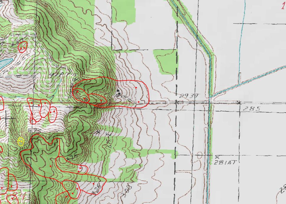
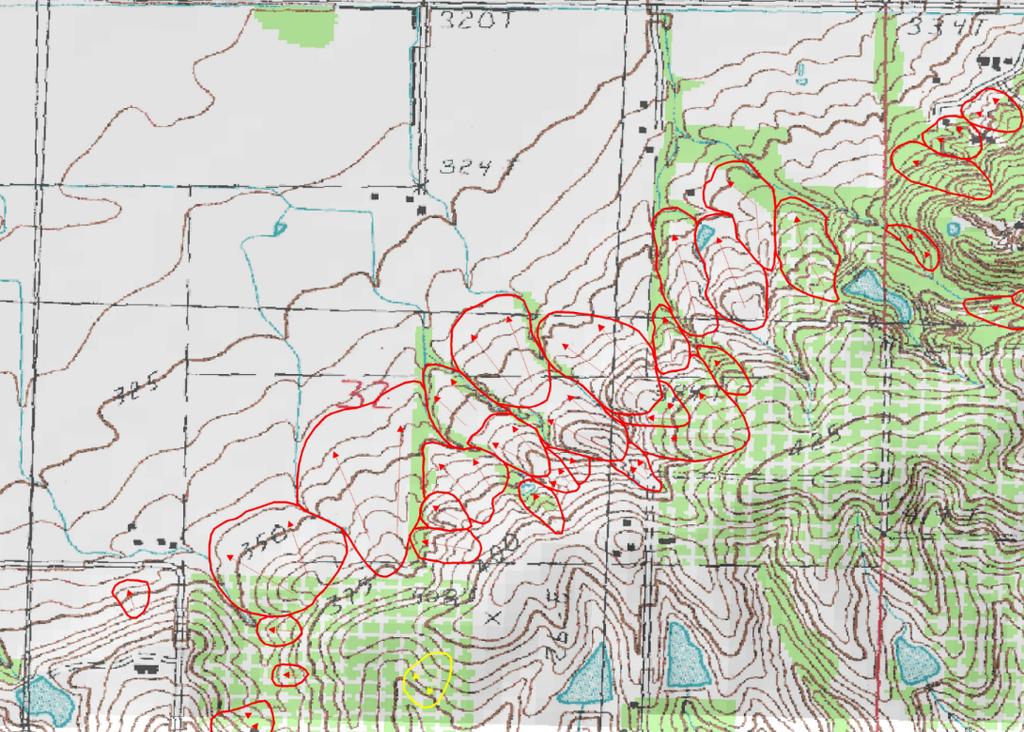
14 Potential for Lateral Spreads in the NMSZ Confined horizons of saturated sands, silty sand and non-cohesive silt, adjacent to channels or other natural depressions: Margins of Crowley s Ridge where river channels come within 3/8 mile Adjacent to sweeping turns of the major river channels Levees and banks of drainage ditches

15 Faulting Recently Observed at Holly Ridge


16 Lateral Spreads Can Cause Horst and Graben Structures to Form in Their Headscarps

17 Classic Features of a Lateral Spread

18 Topographic Algorithms to Identify Anomalous Geomorphic Features Drainage patterns and topographic keys useful in identifying anomalous site characteristics typical of landslides Divergent contours Fan-to-drainage area ratios Stepped fan surfaces Theater-shaped headscarps
19 Topographic Algorithms Tool of tomorrow for rapid screening of large land areas Accuracy depends on quality and scale of topographic maps Will likely supplant stereopair aerial photographic methods for reconnaissance mapping of potential landslide hazards Following initial identification, detailed field mapping and analyses are used to determine if past landslippage actually occurred and whether or not it was seismically-induced

20 GEOLOGY OF SOUTHERN CROWLEY S RIDGE

21 Lateral Spread Mapped Along Crowley s Ridge on LaGrange, Arkansas Quadrangle

22 Cross Section Through Lateral Spread Feature Mapped on LaGrange, Arkansas Quadrangle
23
24
25 Field Identification of Lateral Spreads Saturated cohesionless soils capped by low permeability materials Proximity to adjacent channels or depressions Prominent evacuation grabens because of block movement. These grabens can be infilled Stepped topography typical of repeated events causing lurching of selected zones Sand dikes filled with liquefied material are most common distinguishing feature, but Not all sand dikes are caused by earthquakes
26 Field Methods to Confirm Lateral Spreads Ground Inspection under tree and brush canopy Drainage pattern analysis Backhoe trenches Geophysical techniques very useful Ground Penetrating Radar (GPR) Electrical Resistivity (ER) Induced Polarization (IP)
27 CONCLUSIONS 1. A great number of seismically-induced landslides and lateral spreads appear to exist within the escarpment formed by Crowley s Ridge within the New Madrid Seismic Zone. 2. These have not previously been recognized west of the Mississippi River 3. Future evaluations of seismic hazards in the NMSZ should include these modes of ground deformation, which may cause extensive damage to transportation, utility and drainage infrastructure
28 Special Thanks to: USGS National Earthquake Hazard Reduction Program (NEHRP) University of Missouri Research Board Missouri Geological Survey and Resource Assessment Division Arkansas Geological Commission USGS Mid-Continent Mapping Center Kevin James, UMR GE Department
Identification of Landslides Along Crowley s Ridge in the Upper Mississippi Embayment Using Topographic Algorithms
 Identification of Landslides Along Crowley s Ridge in the Upper Mississippi Embayment Using Topographic Algorithms Briget C. Doyle and J. David Rogers Department of Geological Engineering Department of
SEISMIC THREAT POSED BY THE NEW MADRID SEISMIC ZONE for Earthquakes Mean Business Seminar AT&T Data Center St. Louis, MO Friday February 3, 2006
 BRIEF OVERVIEW OF SEISMIC THREAT POSED BY THE NEW MADRID SEISMIC ZONE for Earthquakes Mean Business Seminar AT&T Data Center St. Louis, MO Friday February 3, 2006 J. David Rogers, Ph.D., P.E., R.G. Karl
General Geologic Setting and Seismicity of the FHWA Project Site in the New Madrid Seismic Zone
 General Geologic Setting and Seismicity of the FHWA Project Site in the New Madrid Seismic Zone David Hoffman University of Missouri Rolla Natural Hazards Mitigation Institute Civil, Architectural & Environmental
What will a Magnitude 6.0 to 6.8 Earthquake do to the St. Louis Metro Area?
 What will a Magnitude 6.0 to 6.8 Earthquake do to the St. Louis Metro Area? J. David Rogers Natural Hazards Mitigation Center University of Missouri-Rolla USGS Mid-Continent Geographic Science Center Missouri
ENTERGY INDEPENDENCE PLANT EAST AND WEST RECYCLE PONDS DEMONSTRATION OF COMPLIANCE WITH EPA CCR RULE SITING CRITERIA , FAULT AREAS.
 ENTERGY INDEPENDENCE PLANT EAST AND WEST RECYCLE PONDS DEMONSTRATION OF COMPLIANCE WITH EPA CCR RULE SITING CRITERIA 257.62, FAULT AREAS Prepared for Entergy Arkansas, Inc. PO Box 551 Little Rock, AR 72203
ENTERGY WHITE BLUFF PLANT RECYCLE POND A AND RECYCLE POND B DEMONSTRATION OF COMPLIANCE WITH EPA CCR RULE SITING CRITERIA 257.
 ENTERGY WHITE BLUFF PLANT RECYCLE POND A AND RECYCLE POND B DEMONSTRATION OF COMPLIANCE WITH EPA CCR RULE SITING CRITERIA 257.62, FAULT AREAS Prepared for Entergy Arkansas, Inc. PO Box 551 Little Rock,
Converse Consultants Geotechnical Engineering, Environmental & Groundwater Science, Inspection & Testing Services
 Converse Consultants Geotechnical Engineering, Environmental & Groundwater Science, Inspection & Testing Services Ms. Rebecca Mitchell Mt. San Antonio College Facilities Planning & Management 1100 North
3.18 GEOLOGY AND SOILS
 3.18 GEOLOGY AND SOILS This section discusses geologic resource concerns as they relate to the environment, public safety, and project design both during construction and after completion of the project.
ENGINEER S CERTIFICATION OF FAULT AREA DEMONSTRATION (40 CFR )
") PLATTE RIVER POWER AUTHORITY RAWHIDE ENERGY STATION BOTTOM ASH TRANSFER (BAT) IMPOUNDMENTS LARIMER COUNTY, CO ENGINEER S CERTIFICATION OF FAULT AREA DEMONSTRATION (40 CFR 257.62) FOR COAL COMBUSTION RESIDUALS
PLATTE RIVER POWER AUTHORITY RAWHIDE ENERGY STATION BOTTOM ASH TRANSFER (BAT) IMPOUNDMENTS LARIMER COUNTY, CO ENGINEER S CERTIFICATION OF FAULT AREA DEMONSTRATION (40 CFR 257.62) FOR COAL COMBUSTION RESIDUALS
SURFACE GEOLOGY AND LIQUEFACTION SUSCEPTIBILITY IN THE INNER RIO GRANDE VALLEY NEAR ALBUQUERQUE, NEW MEXICO
 SURFACE GEOLOGY AND LIQUEFACTION SUSCEPTIBILITY IN THE INNER RIO GRANDE VALLEY NEAR ALBUQUERQUE, NEW MEXICO Keith I. Kelson, Christopher S. Hitchcock, and Carolyn E. Randolph William Lettis & Associates,
Big Rivers Electric Corporation Disposal of Coal Combustion Residuals (CCR) from Electric Utilities Final Rule CCR Impoundment Liner Assessment Report
 from Electric Utilities Final Rule CCR Impoundment Liner Assessment Report") Big Rivers Electric Corporation Disposal of Coal Combustion Residuals (CCR) from Electric Utilities Final Rule CCR Impoundment Liner Assessment Report CCR Surface Impoundment Information Name: Operator:
Big Rivers Electric Corporation Disposal of Coal Combustion Residuals (CCR) from Electric Utilities Final Rule CCR Impoundment Liner Assessment Report CCR Surface Impoundment Information Name: Operator:
Natural hazards in Glenorchy Summary Report May 2010
 Natural hazards in Glenorchy Summary Report May 2010 Contents Glenorchy s hazardscape Environment setting Flood hazard Earthquakes and seismic hazards Hazards Mass movement Summary Glossary Introduction
Physiographic Provinces (West, Ch. 13)
") Geology 229 Engineering Geology Lecture 13 Physiographic Provinces (West, Ch. 13) The definition of the term Physiography Physiography (n.) The science which treats of the earth's exterior physical features,
Geology 229 Engineering Geology Lecture 13 Physiographic Provinces (West, Ch. 13) The definition of the term Physiography Physiography (n.) The science which treats of the earth's exterior physical features,
Guidelines for Site-Specific Seismic Hazard Reports for Essential and Hazardous Facilities and Major and Special-Occupancy Structures in Oregon
 Guidelines for Site-Specific Seismic Hazard Reports for Essential and Hazardous Facilities and Major and Special-Occupancy Structures in Oregon By the Oregon Board of Geologist Examiners and the Oregon
Date: April 2, 2014 Project No.: Prepared For: Mr. Adam Kates CLASSIC COMMUNITIES 1068 E. Meadow Circle Palo Alto, California 94303
 City of Newark - 36120 Ruschin Drive Project Draft Initial Study/Mitigated Negative Declaration Appendix C: Geologic Information FirstCarbon Solutions H:\Client (PN-JN)\4554\45540001\ISMND\45540001 36120
GPR AS A COST EFFECTIVE BEDROCK MAPPING TOOL FOR LARGE AREAS. Abstract
 GPR AS A COST EFFECTIVE BEDROCK MAPPING TOOL FOR LARGE AREAS Dr. Jutta L. Hager, Hager GeoScience, Inc., Waltham, MA Mario Carnevale, Hager GeoScience, Inc., Waltham, MA Abstract Hager GeoScience, Inc.
Use of CPT in Geotechnical Earthquake Engineering
 Use of CPT in Geotechnical Earthquake Engineering Prof. Scott M. Olson, PhD, PE Use of Cone Penetration Test for Foundation Analysis and Design 2006 Annual Meeting Transportation Research Board Geotechnical
3.1 GEOLOGY AND SOILS Introduction Definition of Resource
 3.1 GEOLOGY AND SOILS 3.1.1 Introduction 3.1.1.1 Definition of Resource The geologic resources of an area consist of all soil and bedrock materials. This includes sediments and rock outcroppings in the
Laboratory Exercise #4 Geologic Surface Processes in Dry Lands
 Page - 1 Laboratory Exercise #4 Geologic Surface Processes in Dry Lands Section A Overview of Lands with Dry Climates The definition of a dry climate is tied to an understanding of the hydrologic cycle
Setting MOUNTAIN HOUSE NEIGHBORHOODS I AND J INITIAL STUDY 5. ENVIRONMENTAL CHECKLIST 6. GEOLOGY AND SOILS. Issue
 Issue Less Than Significant or No Impact Potential Significant Impact Adequately Addressed in MEIR MEIR Required Additional Review: No Significant Impact Less Than Significant Impact Due to Mitigation
IMPORTANCE OF GEOLOGIC CHARACTERIZATION FOR LEVEE FOUNDATION AND BORROW MATERIALS AS STUDIED AT THE INDIAN GRAVES LEVEE DISTRICT, ADAMS COUNTY, IL
 IMPORTANCE OF GEOLOGIC CHARACTERIZATION FOR LEVEE FOUNDATION AND BORROW MATERIALS AS STUDIED AT THE INDIAN GRAVES LEVEE DISTRICT, ADAMS COUNTY, IL Conor Watkins Missouri University of Science and Technology
Surface Processes Focus on Mass Wasting (Chapter 10)
") Surface Processes Focus on Mass Wasting (Chapter 10) 1. What is the distinction between weathering, mass wasting, and erosion? 2. What is the controlling force in mass wasting? What force provides resistance?
Surface Processes Focus on Mass Wasting (Chapter 10) 1. What is the distinction between weathering, mass wasting, and erosion? 2. What is the controlling force in mass wasting? What force provides resistance?
IV. ENVIRONMENTAL IMPACT ANALYSIS E. GEOLOGY AND SOILS
 IV. ENVIRONMENTAL IMPACT ANALYSIS E. GEOLOGY AND SOILS The following section is a summary of the geotechnical report conducted for the Proposed Project. The Geotechnical Engineering Investigation (the
2. What type of rocks would you expect in this area, based on the topography? What is your reasoning?
 Geology 101 Bonus Lab Name Topographic maps are useful in helping us interpret the history of the landscape of an area. The questions below are designed to help you learn to interpret topographic maps.
Geology, Soils, and Seismicity
 Section 3.8 Geology, Soils, and Seismicity Introduction This section generally evaluates the effects of the alternatives analyzed in this Supplemental DEIS with regard to geology, soils and seismicity.
This article is provided courtesy of the American Museum of Natural History.
 Avoiding Earthquake Surprises in the Pacific Northwest This article is provided courtesy of the American Museum of Natural History. How Vulnerable Is the Pacific Northwest? Cascadia is a region in the
STAAR Science Tutorial 40 TEK 8.9C: Topographic Maps & Erosional Landforms
 Name: Teacher: Pd. Date: STAAR Science Tutorial 40 TEK 8.9C: Topographic Maps & Erosional Landforms TEK 8.9C: Interpret topographic maps and satellite views to identify land and erosional features and
Downloaded from Downloaded from
 IV SEMESTER BACK-PAPER EXAMINATION-2004 Q. [1] [a] Describe internal structure of the earth with a neat sketch. Write down the major land forms and their characteristics on the earth surface. [8] [b] What
Liquefaction-Induced Lateral Spreading Misko Cubrinovski University of Canterbury, Christchurch, New Zealand
 US New Zealand Japan International Workshop Liquefaction-Induced Ground Movements Effects UC Berkeley, California, 2 4 November 2016 Liquefaction-Induced Lateral Spreading Misko Cubrinovski University
PHASE 1 STUDIES UPDATE EROSION WORKING GROUP
 PHASE 1 STUDIES UPDATE EROSION WORKING GROUP Presented By MICHAEL WOLFF, PG Erosion Study Area Manager West Valley Demonstration Project Quarterly Public Meeting February 24, 2016 OUTLINE Study 1 Terrain
4.9 GEOLOGY AND SOILS
 4.9 GEOLOGY AND SOILS 4.9.1 EXISTING CONDITIONS TOPOGRAPHY AND RELIEF Zone 40 is located in the central portion of Sacramento County. The topography of the county is represented by three physiographic
PALEOGEOGRAPHY of NYS. Definitions GEOLOGIC PROCESSES. Faulting. Folding 9/6/2012. TOPOGRAPHIC RELIEF MAP of NYS GRADATIONAL TECTONIC
 TOPOGRAPHIC RELIEF MAP of NYS PALEOGEOGRAPHY of NYS Prof. Anthony Grande AFG 2012 Definitions GEOLOGIC PROCESSES Geography: study of people living on the surface of the earth. Geology: the scientific study
4.5 GEOLOGY AND SOILS
 4.5 GEOLOGY AND SOILS This section addresses the project site geology and soils and analyzes potential changes that would result from development of the Wye Specific Plan project. 4.5.1 Environmental Setting
Science EOG Review: Landforms
 Mathematician Science EOG Review: Landforms Vocabulary Definition Term canyon deep, large, V- shaped valley formed by a river over millions of years of erosion; sometimes called gorges (example: Linville
FUNDAMENTALS OF ENGINEERING GEOLOGY
 FUNDAMENTALS OF ENGINEERING GEOLOGY Prof. Dr. HUSSEIN HAMEED KARIM Building and Construction Engineering Department 2012 Preface The impulse to write this book stemmed from a course of geology given by
Exploring Geography. Chapter 1
 Exploring Geography Chapter 1 The Study of Geography Geography is the study of where people, places, and things are located and how they relate to each other. Greek meaning writing about or describing
UNIT 3 GEOLOGY VOCABULARY FLASHCARDS THESE KEY VOCABULARY WORDS AND PHRASES APPEAR ON THE UNIT 3 CBA
 UNIT 3 GEOLOGY VOCABULARY FLASHCARDS THESE KEY VOCABULARY WORDS AND PHRASES APPEAR ON THE UNIT 3 CBA A map that shows Earth s Topographic Map surface topography, which is Earth s shape and features Contour
GEOL 380: Earthquake Hazards in the Puget Sound Region (in class and assignment) Due in class Wednesday, Nov 109th
 Due in class Wednesday, Nov 109th") GEOL 380: Earthquake Hazards in the Puget Sound Region (in class and assignment) Due in class Wednesday, Nov 109th The purpose of this exercise/assignment is for you to gain practice and experience in
GEOL 380: Earthquake Hazards in the Puget Sound Region (in class and assignment) Due in class Wednesday, Nov 109th The purpose of this exercise/assignment is for you to gain practice and experience in
IV. ENVIRONMENTAL IMPACT ANALYSIS E. GEOLOGY/SOILS
 IV. ENVIRONMENTAL IMPACT ANALYSIS E. GEOLOGY/SOILS Except where otherwise noted, the following Section is based on the Preliminary Geotechnical Investigation, Proposed Medical Office Buildings and Mixed-Use
Earthquake-induced landslide distribution and hazard mapping. Megh Raj Dhital Central Department of Geology, Tribhuvan University
 Earthquake-induced landslide distribution and hazard mapping Megh Raj Dhital Central Department of Geology, Tribhuvan University Contents Geological setting of Gorkha earthquake Peak ground acceleration
THE BEDROCK SURFACE AND FORMER DRAINAGE SYSTEMS OF MONTGOMERY COUNTY, OHIO 1
 THE BEDROCK SURFACE AND FORMER DRAINAGE SYSTEMS OF MONTGOMERY COUNTY, OHIO 1 STANLEY E. NORRIS, Geologist, U. S. Geological Survey, Columbus, Ohio INTRODUCTION The bedrock surface of Montgomery County,
J.H. Campbell Generating Facility Pond A - Location Restriction Certification Report
 J.H. Campbell Generating Facility Pond A - Location Restriction Certification Report Pursuant to: 40 CFR 257.60 40 CFR 257.61 40 CFR 257.62 40 CFR 257.63 40 CFR 257.64 Submitted to: Consumers Energy Company
Earthquakes Earth, 9th edition, Chapter 11 Key Concepts What is an earthquake? Earthquake focus and epicenter What is an earthquake?
 1 2 3 4 5 6 7 8 9 10 Earthquakes Earth, 9 th edition, Chapter 11 Key Concepts Earthquake basics. "" and locating earthquakes.. Destruction resulting from earthquakes. Predicting earthquakes. Earthquakes
Investigation of Liquefaction Behaviour for Cohesive Soils
 Proceedings of the 3 rd World Congress on Civil, Structural, and Environmental Engineering (CSEE 18) Budapest, Hungary April 8-10, 2018 Paper No. ICGRE 134 DOI: 10.11159/icgre18.134 Investigation of Liquefaction
Earth s Continents and Seafloors. GEOL100 Physical Geology Ray Rector - Instructor
 Earth s Continents and Seafloors GEOL100 Physical Geology Ray Rector - Instructor OCEAN BASINS and CONTINENTAL PLATFORMS Key Concepts I. Earth s rocky surface covered by of two types of crust Dense, thin,
New Madrid and Central U.S. Region Earthquake Hazard
 New Madrid and Central U.S. Region Earthquake Hazard Rob Williams U.S. Geological Survey, Golden, CO March 16, 2017 Reelfoot Lake, TN U.S. Department of the Interior U.S. Geological Survey 1811-12 New
4.10 GEOLOGY, SOILS, AND SEISMICITY
 4.10 GEOLOGY, SOILS, AND SEISMICITY 4.10.1 INTRODUCTION This section describes the geology of the SVRTC and the susceptibility of site soils to seismically induced hazards. Faults in the corridor and past
IV. ENVIRONMENTAL IMPACT ANALYSIS E. GEOLOGY AND SOILS
 IV. ENVIRONMENTAL IMPACT ANALYSIS E. GEOLOGY AND SOILS INTRODUCTION This section evaluates potential impacts related to geology, including seismicity, and soils associated with development of the proposed
Laboratory Exercise #3 The Hydrologic Cycle and Running Water Processes
 Laboratory Exercise #3 The Hydrologic Cycle and Running Water Processes page - 1 Section A - The Hydrologic Cycle Figure 1 illustrates the hydrologic cycle which quantifies how water is cycled throughout
New Madrid Earthquakes
 Seismic Hazard Maps A presentation by Dr. Chris Cramer, U.S. Geological Survey, Memphis, TN at University of Memphis, TN November 22, 2004 1811-12 New Madrid Earthquakes 1 1886 Charleston Earthquake 2
Bonn, Germany MOUTAZ DALATI. General Organization for Remote Sensing ( GORS ), Syria Advisor to the General Director of GORS,
, Syria Advisor to the General Director of GORS,") Bonn, Germany Early Warning System is needed for Earthquakes disaster mitigation in Syria Case Study: Detecting and Monitoring the Active faulting zones along the Afro-Arabian-Syrian Rift System MOUTAZ
Bonn, Germany Early Warning System is needed for Earthquakes disaster mitigation in Syria Case Study: Detecting and Monitoring the Active faulting zones along the Afro-Arabian-Syrian Rift System MOUTAZ
IV. ENVIRONMENTAL IMPACT ANALYSIS E. GEOLOGY AND SOILS
 IV. ENVIRONMENTAL IMPACT ANALYSIS E. GEOLOGY AND SOILS The following analysis is based on the Geotechnical Investigation Report, Proposed Mid-Rise Multi- Family Residential Development Project Wetherly
USGS: USGS: NEIC NEIC
 Triggered Earthquakes in North-Central Arkansas and their Relationship to Class II UIC Wells Scott M. Ausbrooks, The Arkansas Geological Survey Steve Horton, Ph.D., CERI at University i of Memphis Contributors:
Soils, Hydrogeology, and Aquifer Properties. Philip B. Bedient 2006 Rice University
 Soils, Hydrogeology, and Aquifer Properties Philip B. Bedient 2006 Rice University Charbeneau, 2000. Basin Hydrologic Cycle Global Water Supply Distribution 3% of earth s water is fresh - 97% oceans 1%
Regional Geomorphology
 Chapter 2 Environmental Setting Regional Geomorphology The study area is set in the floodplain of the Mississippi River, just south of Plaquemine, Louisiana. The river has occupied its current position
LAB 5: LANDSLIDE RECOGNITION AND MAPPING
 Geology 350 1 LAB 5: LANDSLIDE RECOGNITION AND MAPPING OBJECTIVES: a. to learn to recognize and classify landslides on airphotos and topographic maps b. to learn to recognize landslide topography on topographic
GEOLOGIC REVIEW AND RECONNAISSANCE
 GEOTECHNICAL ENVIRONMENTAL WATER RESOURCES CONSTRUCTION SERVICES June 1, 2012 Project No. 9472.000.000 Ms. Ginger Zhang East Bay Municipal Utility District (EBMUD) 375 Eleventh Street Oakland, CA 94607
Elastic Rebound Theory
 Earthquakes Elastic Rebound Theory Earthquakes occur when strain exceeds the strength of the rock and the rock fractures. The arrival of earthquakes waves is recorded by a seismograph. The amplitude of
Plate Tectonics Tutoiral. Questions. Teacher: Mrs. Zimmerman. Plate Tectonics and Mountains Practice Test
 Teacher: Mrs. Zimmerman Print Close Plate Tectonics and Mountains Practice Test Plate Tectonics Tutoiral URL: http://www.hartrao.ac.za/geodesy/tectonics.html Questions 1. Fossils of organisms that lived
patersongroup Consulting Engineers April 20, 2010 File: PG1887-LET.01R Novatech Engineering Consultants Suite 200, 240 Michael Cowpland Drive
 patersongroup April 20, 2010 File: PG1887-LET.01R Novatech Engineering Consultants Suite 200, 240 Michael Cowpland Drive Ottawa, Ontario K2M 1P6 Attention: Mr. Adam Thompson Consulting Engineers 28 Concourse
3.8 Geology/Soils. Environmental Setting. Topography. Geology and Soils
 3.8 Geology/Soils This section examines whether implementation of the 2004 Land Use Mobility Elements, Zoning Code Revisions, and Central District Specific Plan the will expose people or structures to
Objective 3: Earth and Space Systems
 Name Class Period: Objective 3: Earth and Space Systems 1. The diagram above shows the orbit of the moon around Earth. At which point in the moon s orbit will a person standing on Earth see a waxing crescent
Name: Date: Class: Louisiana: Our History, Our Home Chapter 1: Louisiana s Geography - Section 2: Natural Regions Guided Reading
 Instructions: Read the section and complete each item with words from the passages in this section. 1. The diversity of Louisiana s can surprise residents and visitors alike. 2. Physical geography is concerned
Plate Tectonics - Demonstration
 Name: Reference: Prof. Larry Braile - Educational Resources Copyright 2000. L. Braile. Permission granted for reproduction for non-commercial uses. http://web.ics.purdue.edu/~braile/indexlinks/educ.htm
An Introduction to Field Explorations for Foundations
 An Introduction to Field Explorations for Foundations J. Paul Guyer, P.E., R.A. Paul Guyer is a registered mechanical engineer, civil engineer, fire protection engineer and architect with over 35 years
DAMAGE ANALYSIS OF WATER SUPPLY PIPES DUE TO THE 2004 NIIGATA-KEN CHUETSU, JAPAN EARTHQUAKE ABSTRACT
 Proceedings of the 8 th U.S. National Conference on Earthquake Engineering April 18-22, 2006, San Francisco, California, USA Paper No. 1163 DAMAGE ANALYSIS OF WATER SUPPLY PIPES DUE TO THE 2004 NIIGATA-KEN
Debris flow: categories, characteristics, hazard assessment, mitigation measures. Hariklia D. SKILODIMOU, George D. BATHRELLOS
 Debris flow: categories, characteristics, hazard assessment, mitigation measures Hariklia D. SKILODIMOU, George D. BATHRELLOS Natural hazards: physical phenomena, active in geological time capable of producing
Comparison between predicted liquefaction induced settlement and ground damage observed from the Canterbury earthquake sequence
 Power, P.M. & Jacka, M. (2013) the Canterbury earthquake sequence Proc. 19 th NZGS Geotechnical Symposium. Ed. CY Chin, Queenstown Comparison between predicted liquefaction induced settlement and ground
THE MAMMOTH "EARTHQUAKE FAULT" AND RELATED FEATURES IN MON0 COUNTY, CALIFORNIA* By H. BENIOFF and B. GUTENBERG
 THE MAMMOTH "EARTHQUAKE FAULT" AND RELATED FEATURES IN MON0 COUNTY, CALIFORNIA* By H. BENIOFF and B. GUTENBERG IN UNDERTAKING this work it was our intention to investigate the well-known "Earthquake Fault"
8 th Grade Science Plate Tectonics and Topography Review
 8 th Grade Science Plate Tectonics and Topography Review #1 Scientists believe that the land masses of Earth were once joined together as one supercontinent called. A: Australia B: Wegner C: Pangaea D:
PART 5 MECHANISMS OF GROUND SETTLEMENT IN GREATER NEW ORLEANS
 PART 5 MECHANISMS OF GROUND SETTLEMENT IN GREATER NEW ORLEANS Predicted water depth in New Orleans flood inundation area based on water level of 2.37 ft in Lake Ponchartrain on Sept 2, 2005. Overlay on
ES 104 # 5 EARTHQUAKES:
 ES 104 Laboratory # 5 EARTHQUAKES: Epicenter Determination, Seismic Waves, and Hazards Introduction Earthquakes are vibrations of Earth caused by large releases of energy that accompany volcanic eruptions,
Paleoseismic Investigations for Determining the Design Ground Motions for Nuclear Power Plants
 Paleoseismic Investigations for Determining the Design Ground Motions for Nuclear Power Plants Russell A. Green Department of Civil and Environmental Engineering Purdue Geotechnical Society Workshop May
Beneath our Feet: The 4 Layers of the Earty by Kelly Hashway
 Beneath our Feet: The 4 Layers of the Earty by Kelly Hashway The Earth is more than a giant ball made up of dirt, rocks, and minerals. The Earth may look like a giant ball from when looking at it from
discussion of North America s physical features, including its landforms and bodies of
 Chapter 7 Natural Environments of North America Chapter 7 focuses on the natural environments of North America. The chapter opens with a discussion of North America s physical features, including its landforms
Figure 1. Map of Feather River Basin in northern California. (A) Region straddles the northwestern Sierra Nevada and Sacramento Valley.
 Region straddles the northwestern Sierra Nevada and Sacramento Valley.") Figure 1. Map of Feather River Basin in northern California. (A) Region straddles the northwestern Sierra Nevada and Sacramento Valley. (B) Feather River Basin with Yuba and Bear subbasins. Most hydraulic
Figure 1. Map of Feather River Basin in northern California. (A) Region straddles the northwestern Sierra Nevada and Sacramento Valley. (B) Feather River Basin with Yuba and Bear subbasins. Most hydraulic
Search and Discovery Article #40536 (2010) Posted June 21, 2010
 Posted June 21, 2010") Modern Examples of Mass Transport Complexes, Debrite and Turbidite Associations: Geometry, Stratigraphic Relationships and Implications for Hydrocarbon Trap Development* Fabiano Gamberi 1, Marzia Rovere
Modern Examples of Mass Transport Complexes, Debrite and Turbidite Associations: Geometry, Stratigraphic Relationships and Implications for Hydrocarbon Trap Development* Fabiano Gamberi 1, Marzia Rovere
Earthquakes. Earthquakes are caused by a sudden release of energy
 Earthquakes Earthquakes are caused by a sudden release of energy The amount of energy released determines the magnitude of the earthquake Seismic waves carry the energy away from its origin Fig. 18.1 Origin
Location Option Details. 1. Florida
 1. Florida Florida has the smallest number of earthquaes in the United States. Florida is the U.S. location where hurricanes are most frequent. Of the six deadliest hurricanes to hit the continental U.S.,
Earth and Space Science Semester 2 Exam Review. Part 1. - Convection currents circulate in the Asthenosphere located in the Upper Mantle.
 Earth and Space Science 2015 Semester 2 Exam Review Part 1 Convection -A form of heat transfer. - Convection currents circulate in the Asthenosphere located in the Upper Mantle. - Source of heat is from
Adlai E. Stevenson High School Course Description
 Adlai E. Stevenson High School Course Description Division: Content Objectives: Describe how scientists measure earthquakes, identify their locations, and assess the damage caused. Describe how the processes
Name: Mid-Year Review #2 SAR
 Name: Mid-Year Review #2 SAR Base your answers to questions 1 through 3 on on the diagram below, which shows laboratory materials used for an investigation of the effects of sediment size on permeability,
Interpretation of Ground Shaking from Paleoliquefaction Features
 Grant Award 01HQGR0030 Dr. Timothy D. Stark Stark Consultants, Inc. Interpretation of Ground Shaking from Paleoliquefaction Features NEHRP Element: II (Memphis Metropolitan Area) Research supported by
GEOLOGY AND SOILS. This chapter summarizes geologic and geotechnical aspects of the site as they relate to the Project.
 9 GEOLOGY AND SOILS INTRODUCTION This chapter summarizes geologic and geotechnical aspects of the site as they relate to the Project. This chapter utilizes information from the following reports prepared
MISSOURI LiDAR Stakeholders Meeting
 MISSOURI LiDAR Stakeholders Meeting East-West Gateway June 18, 2010 Tim Haithcoat Missouri GIO Enhanced Elevation Data What s different about it? Business requirements are changing.fast New data collection
IV. ENVIRONMENTAL IMPACT ANALYSIS G. GEOLOGY AND SOILS
 IV. ENVIRONMENTAL IMPACT ANALYSIS G. GEOLOGY AND SOILS The following section is based upon the City of El Segundo General Plan and General Plan EIR and addresses the following geologic issues: soil erosion,
STRUCTURAL STABILITY ASSESSMENT
 STRUCTURAL STABILITY ASSESSMENT CFR 257.73(d) Bottom Ash Pond Complex Cardinal Plant Brilliant, Ohio October, 2016 Prepared for: Cardinal Operating Company Cardinal Plant Brilliant, Ohio Prepared by: Geotechnical
IV. ENVIRONMENTAL IMPACT ANALYSIS G. GEOLOGY AND SOILS
 IV. ENVIRONMENTAL IMPACT ANALYSIS G. GEOLOGY AND SOILS The following section is a summary of the geotechnical report conducted for the proposed project. The Report of Geotechnical Investigation Proposed
STUDY GUIDE FOR MID-TERM EXAM KEY. Color, luster, cleavage, fracture, hardness, taste, smell, fluorescence, radioactivity, magnetism
 STUDY GUIDE FOR MID-TERM EXAM KEY 1. In which type of rock are fossils most likely to be found? Sedimentary Rocks 2. Which mineral is easily identified by smell? Sulfur 3. Which natural resource makes
6. GEOTECHNICAL STUDIES, SEISMICITY AND VOLCANISM
 Geotechnical Studies, Seismicity, and Volcanism Bristol Bay Drainages 6. GEOTECHNICAL STUDIES, SEISMICITY AND VOLCANISM 6.1 Introduction This chapter describes the baseline geotechnical characteristics
Geophysical surveying for imaging near-surface structure and for characterizing its geotechnical properties
 Geophysical surveying for imaging near-surface structure and for characterizing its geotechnical properties INAZAKI Tomio Geology and Geotechnical Research Group, Public Works Research Institute Abstract
Special edition paper
 Development of a System for Natural Disaster Risk Factor Evaluation by the EADaS Method Ryuji Oshima* Asako Togari* Masahiko Tomori* Natural disasters of a variety of scales occur along railway lines,
Photogeologic Mapping of Mars
 Exercise Two and Fifteen are suggested as introductory exercises. 2.0 hours Exercise Seventeen Photogeologic Mapping of Mars Instructor Notes Suggested Correlation of Topics Deductive reasoning, geologic
Foundations on Deep Alluvial Soils
 Canterbury Earthquakes Royal Commission Hearings 25 October 2011, Christchurch GEO.CUB.0001.1-35.1 Foundations on Deep Alluvial Soils Misko Cubrinovski, Ian McCahon, Civil and Natural Resources Engineering,
Downtown Anchorage Seismic Risk Assessment & Land Use Regulations to Mitigate Seismic Risk
 Prepared for: The Municipality of Anchorage Planning Department and the Geotechnical Advisory Commission Downtown Anchorage Seismic Risk Assessment & Land Use Regulations to Mitigate Seismic Risk Prepared
3.12 Geology and Topography Affected Environment
 3 Affected Environment and Environmental Consequences 3.12 Geology and Topography 3.12.1 Affected Environment 3.12.1.1 Earthquakes Sterling Highway MP 45 60 Project Draft SEIS The Kenai Peninsula is predisposed
Land Subsidence. Land subsidence is defined as the lowering of the land surface.
 Land Subsidence Land subsidence is defined as the lowering of the land surface. Many different factors can cause the land surface to subside. Subsidence can occur rapidly due to: a sinkhole or under ground
Geologic Mapping Regional Tournament Trial Event
 Geologic Mapping Regional Tournament Trial Event A TEAM OF UP TO: 2 Team Name AVAILABLE TIME: 50 min Required Materials: Each team MUST have a protractor, ruler, non-programmable calculator, colored pencils,
3.0 SUMMARY OF FINDINGS
 AECOM 500 W Jefferson St. Suite 1600 Louisville, KY 40202 www.aecom.com 502-569-2301 tel 502-569-2304 fax October 17, 2018 Big Rivers Electric Corporation Sebree Generating Station 9000 Highway 2096 Robards,
GEOL.3250 Geology for Engineers Plate Tectonics - Geomagnetism, Earthquakes, and Gravity
 Name GEOL.3250 Geology for Engineers Plate Tectonics - Geomagnetism, Earthquakes, and Gravity I. Geomagnetism The earth's magnetic field can be viewed as a simple bar magnet located near the center of