GEOLOGIC REVIEW AND RECONNAISSANCE
|
|
|
- Kathlyn Mason
- 5 years ago
- Views:
Transcription
 375 Eleventh Street Oakland, CA 94607 Subject: 39 th Avenue Reservoir 4290 Maybelle Avenue Oakland, California Dear Ms.")
1 GEOTECHNICAL ENVIRONMENTAL WATER RESOURCES CONSTRUCTION SERVICES June 1, 2012 Project No Ms. Ginger Zhang East Bay Municipal Utility District (EBMUD) 375 Eleventh Street Oakland, CA Subject: 39 th Avenue Reservoir 4290 Maybelle Avenue Oakland, California Dear Ms. Zhang: GEOLOGIC REVIEW AND RECONNAISSANCE At your request, we have conducted a site-specific geologic evaluation of the East Bay Municipal Utility District (EBMUD) 39 th Avenue Reservoir in Oakland, California. Based on information provided EBMUD we understand that the 39th Avenue Reservoir was constructed in 1920 and is located on an approximately 8 acre site west of Highway 13 in the Redwood Heights area of Oakland. The site is bounded by 39th Avenue to the northwest and Reinhardt Drive to the east. The purpose of our geologic evaluation was to provide a preliminary characterization of the geologic conditions and hazards present at the site and provide recommendations for additional field exploration, if necessary. Our scope included the following: 1. Review of available geologic maps, aerial photographs, plans, and literature relevant to the site. 2. A site reconnaissance to observe site conditions and to look for potential fault related features such as offset curbs, en-echelon cracking, fault scarps, etc. 3. Delineate fault locations on a plan with reference to the site based on review of available data and site reconnaissance. 4. Prepare cross sections across the main and auxiliary dams utilizing existing plans, data and information provided by EBMUD. 5. Preparation of this letter summarizing the findings of our review and site reconnaissance, and provide recommendations for field exploration, if necessary. 6. In addition, EBMUD provided us with plans, reports, boring logs and piezometer and survey data for the site (see attached references) Crow Canyon Place, Suite 250 San Ramon, CA (925) Fax (888)
2 East Bay Municipal Utility District (EBMUD) th Avenue Reservoir June 1, 2012 GEOLOGIC REVIEW AND RECONNAISSANCE Page 2 SITE DESCRIPTION Based on review of information provided by EBMUD we understand that the reservoir has a capacity of 10.2 million gallons. Borings drilled within the reservoir in 1959 as part of a rehabilitation soils investigation indicate that the reservoir is lined with 5 to 6 inch concrete slabs. The reservoir is covered with corrugated aluminum, steel and fiberglass roof panels. A roughly 11 to 12 foot wide, paved, perimeter maintenance road surrounds the reservoir. An approximately 2.5 foot wide concrete drainage ditch is present on the outside edge of the perimeter maintenance road. Seven drop inlet structures are present in-line with the drainage ditch. Based on personal communication from EBMUD engineers we understand that subdrains are present below the base of the reservoir and that these drain into a drainage structure east of the auxiliary dam. We also understand that the reservoir inlet/outlet line runs below the main dam towards the west. Elevations at the site based on NGVD 29 range from approximately 411 feet at the base of the reservoir to approximately 454 feet at the top of the existing cut slope north of the reservoir. The reservoir crest is at an elevation of approximately 433 feet. The lowest elevation that is not inside of the reservoir is approximately 418 feet at a low spot located approximately 150 feet west of the main dam. Ponded water was observed at this location at the time of our site visit on April 17, Review of the 1897 Concord fifteen minute quadrangle covering the site and the June 30, 1919 East Bay Water Company plan for the reservoir indicate that the reservoir was constructed in an area that was a natural closed depression or pond. The reservoir was constructed with cuts and fills that enhanced the existing pond. The main dam was constructed by placing a fill embankment in roughly the central portion of the pond. A fill embankment was also placed at the eastern end of the natural depression to form the auxiliary dam. The 1919 plans indicate that approximately 3 to 4 feet of native material was excavated from the area that now forms the base and lower side slopes of the existing reservoir. This material was likely used as fill for construction of the two fill embankment dams. The fill embankments have inclinations of roughly 2:1 on their outboard sides and 3:1 on the reservoir sides. REGIONAL GEOLOGY The 39 th Avenue Reservoir site is located on the western edge of the East Bay Hills. The East Bay Hills lie within the region of coastal California referred to by geologists as the Coast Ranges geomorphic province. The Coast Ranges have experienced a complex geological history characterized by Late Tertiary folding and faulting that has resulted in a series of northwest-trending mountain ranges and intervening valleys. The site is located on the western edge of an uplifted range of hills locally referred to as the East Bay Hills block, bounded on the west by the active Hayward Fault and on the east by the active Calaveras Fault.
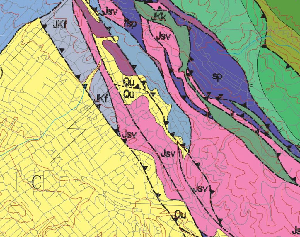
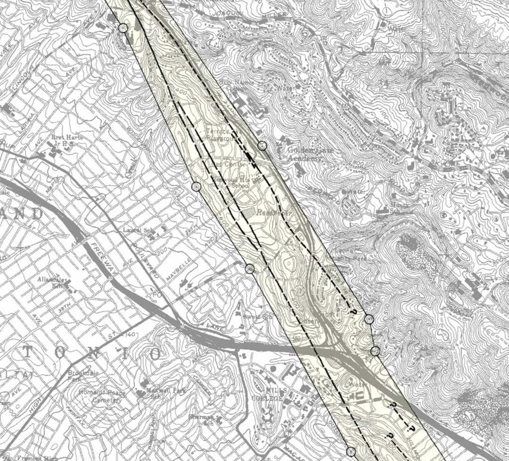
3 East Bay Municipal Utility District (EBMUD) th Avenue Reservoir June 1, 2012 GEOLOGIC REVIEW AND RECONNAISSANCE Page 3 Bedrock in the Coast Ranges consists of igneous, metamorphic and sedimentary rocks that range in age from Jurassic to Pleistocene. The present physiography and geology of the Coast Ranges are the result of deformation and deposition along the tectonic boundary between the North American plate and the Pacific plate. Plate boundary fault movements are largely concentrated along the well-known fault zones, which in the area include the San Andreas, Hayward, and Calaveras faults, as well as other lesser-order faults. SITE GEOLOGY More specifically, the site is located within an area that has geomorphology that is strongly influenced by the Hayward fault zone in the East Bay Hills. Based on geologic mapping by Dibblee (2005), Graymer (1995), Crane (1988), and Radbruch (1969) the site is underlain by volcanic rock designated by most as the Jurassic Leona Rhyolite - Jsv (Figure 1). The Leona Rhyolite comprises a late Jurassic keratophyre and quartz keratophyre composed of highly altered, intermediate silicic lavas and dike rocks that stratigraphically overly the Coast Range ophiolite complex. Based on outcrops observed in the cut-slopes at the site the Leona Rhyolite can be described as tan to brown, moderately strong to strong, closely fractured to crushed, and highly weathered. The geologic structure in the area is dominated by the historically active, right-lateral, strike-slip Hayward fault, which can be characterized as an anastomosing series of fault splays, fault bound blocks/slivers and smaller order en echelon faults, and pressure ridges. Residual soil and colluvium are present overlying the bedrock at most locations at the site. The colluvium is likely thickest near the central part of the original pond or closed depression that occupied the site prior to construction of the reservoir. The native soils generally comprise light brown to dark brown silty clays and sandy clays with scattered angular gravel derived from the underlying Leona Rhyolite. Artificial fill is also present at various areas of the site most notably the two reservoir embankments. Based on 1959 boring logs the artificial fill generally comprises brown to dark grey silty clay with varying amounts of rhyolite gravel. FAULTING AND SURFACE RUPTURE The site is located within a State of California Earthquake Fault Zone and Holocene active faults are known to pass through the subject site, according to the published State of California Earthquake Fault Zone Map covering the site (Reference 2, CGS, 1982) (Figure 2). According to the State of California, a fault is considered to be active if it has had identifiable movement within the last 11,000 years; the time period for a potentially active fault is approximately 1.6 million years. According to the State Earthquake Fault Zone Map two active traces of the Hayward fault are mapped as approximately located crossing the site with a northwesterly trend and a third trace is mapped east of the site. One of the approximately located traces passes through the inboard side of the main dam and the other mapped trace is located approximately 170 feet west of the western edge of the reservoir. Based on information compiled by Lienkaemper discussed below, the mapped fault trace located approximately 170 feet west of the reservoir displays the most definitive evidence of fault creep. A third mapped trace of the fault is located approximately 650 feet east of the auxiliary dam.
4 East Bay Municipal Utility District (EBMUD) th Avenue Reservoir June 1, 2012 GEOLOGIC REVIEW AND RECONNAISSANCE Page 4 In 1977, ENGEO conducted an Alquist Priolo Investigation of the Hayward Fault Zone on a site located approximately 1800 feet northwest of the subject site. The investigation found clear evidence for recent fault activity in the vicinity of two mapped traces of the Hayward fault (Middle and Eastern). The investigation concluded that the Middle zone contained the most active trace of the fault. The middle zone is along the same trend as the two traces mapped through the subject site and the eastern zone is along the same trend as the eastern trace mapped 650 feet east of the auxiliary dam. Creep has been documented on the Hayward fault in this area. This means that some segments of the fault move incrementally in very small sub-millimeter displacements (creep) with no associated seismicity (A-seismic). Studies by Lienkaemper (2006, updated 2008) to show the location of evidence for recent movement on active traces within the Hayward Fault Zone indicates distinct and certain evidence of right lateral offset curbs, fence lines, left stepping en echelon cracks within pavement and surveyed offset frames in the vicinity of the site. These features are recent evidence of right-lateral creep along the westernmost mapped trace of the Hayward fault. The fault trace based on Lienkaemper s mapping is shown on Figure 3. In the vicinity of the site, Lienkaemper s mapped fault trace compares closely with the westernmost mapped trace shown on the State Earthquake Fault Zone Map. The differences between the mapped traces are likely related to the different data and information used to determine the location of the fault or faults, the overall uncertainty with respect to the faults exact location in addition to the fact that surface rupture and deformation should be anticipated to occurs in a zone that is wider than the lines that are shown on the maps. It should be noted that the Hayward Fault Zone Boundary as mapped on the State of California Earth Quake Fault Zone Map (1982) in the vicinity of the site is approximately 2,200 feet wide from east to west. Based on our review of 1939 stereo paired aerial photographs covering the site we noted two distinct fault parallel features that correspond with the mapped fault trace that crosses the main dam. One of the features evident in the historic photos is a very distinct linear swale south of the reservoir that disappears abruptly at the southern edge of the reservoir (Figure 3). The other feature is a fault parallel break in slope north of the reservoir. The most recent major earthquake to occur on the Hayward fault took place in 1868 and generated an approximately 25 mile long surface rupture from Warm Springs in Fremont to southern Berkeley. Historical survey data indicate an average of approximately 6 feet of horizontal movement occurred along the ruptured fault segment during the 1868 earthquake. The estimated recurrence interval for major earthquakes along the Hayward fault is approximately 150 years and the estimated slip rate is roughly 9mm/yr ±2mm/yr. Typical moment magnitude estimates for a major earthquake on the Hayward fault range from 6.5 to 7.3. Estimated maximum surface displacements vary significantly with earthquake moment magnitude. Based on empirical relationships among moment magnitude, rupture length and surface displacement developed by Wells and Coppersmith (1994) the estimated maximum surface displacement along the Hayward fault for a moment magnitude 7.3 earthquake is approximately 17 feet. Based on the same relationships the estimated maximum surface displacement along the Hayward fault for a moment magnitude 6.5 is approximately 1.5 feet.
5 East Bay Municipal Utility District (EBMUD) th Avenue Reservoir June 1, 2012 GEOLOGIC REVIEW AND RECONNAISSANCE Page 5 SEISMICITY Numerous small earthquakes occur every year in the region, and as discussed above large (>M7) earthquakes have been recorded and can be expected to occur in the future. Based on the 2010 USGS Quaternary Fault and Fold Database (QFFD), the nearest active fault, as discussed above, is the Hayward fault. As discussed above the Hayward fault at this location is mapped as three approximately located active traces on the State of California Earthquake Fault Zone Map (Reference 2, Figure 2). Therefore, we recommend that the fault trace mapped closest to the site be used in the seismic analysis. In this case, we recommend that the fault mapped through the main dam be used to determine the distance because it is closest to the critical features to be analyzed. As part of the Uniform California Earthquake Rupture Forecast Version 2 (UCERF 2) moment magnitudes for various fault segment rupture scenarios have been modeled for the segments of the Hayward-Rogers Creek faults. Fault rupture models used in UCERF 2 divide the Hayward-Rogers Creek faults into three segments that include the Hayward South (HS), the Hayward North (HN) and the Rogers Creek (RC). Moment magnitudes for the various modeled rupture combinations range from 6.5 to 7.3. The estimated moment magnitude for an earthquake where the entire Hayward-Rogers-Creek fault ruptures is 7.3. Other active faults located near the site include the Northern Calaveras fault, located approximately 9 miles to the east, the Concord-Green Valley fault, located approximately 13 miles to the east, and the San Andreas fault located approximately 18 miles to the west. Many earthquakes of low magnitude occur every year throughout the region, most are concentrated along the San Andreas, Hayward, and Calaveras Faults. The Uniform California Earthquake Rupture Forecast (UCERF, 2008) evaluated the 30-year probability of a M6.7 or greater earthquake occurring on the known active fault systems in the Bay Area, including the Hayward fault. The UCERF generated an overall probability of 63 percent for the Bay Area as a whole, and a probability of 31 percent for the Hayward fault, 7 percent for the Calaveras fault, and 3 percent for the Concord-Green Valley fault. COMPILATION OF MAPS, PLANS AND REPORTS On April 19, 2012, an ENGEO Certified Engineering Geologist made a visit to the EBMUD office in Oakland to review available plans and reports regarding the reservoir. For our review, we were provided various documents and among them was a June 30, 1919 plan that showed original ground contours and proposed grading contours for construction of the reservoir. We were also provided with a 1960 soils and foundation investigation report for the rehabilitation of the reservoir. The 1960 report included subsurface boring data and a site plan depicting boring locations. We compiled this information in AutoCAD with geo-referenced 1/9 th arc second topography from LIDAR mapping along the Hayward fault, historic aerial photo imagery, historic topographic maps and various geologic and fault maps covering the area. Using the compiled information we constructed a preliminary geologic map (Figure 4) and cross sections through the most critical areas of the main dam (Section 1) and auxiliary dam (Section 2)
6 East Bay Municipal Utility District (EBMUD) th Avenue Reservoir June 1, 2012 GEOLOGIC REVIEW AND RECONNAISSANCE Page 6 (see attached Figure 5). Elevations in the cross sections are based on NGVD 29. Based on the existing subsurface boring data it appears that both of the dams were constructed directly on existing native clayey soils. Cross Section 1 indicates up to approximately 20 feet of native soil underlying the main dam fill embankment and Cross Section 2 indicates roughly 10 feet of native soil underlying the auxiliary dam fill embankment. Cross Section 1 crosses the two western mapped traces of the Hayward fault according to the State of California AP Map. One of the mapped traces projects through the reservoir side of the main dam fill embankment (Figure 5). Piezometer data from 4 piezometers (UD-20, 21, 22 and 23) was provided for our review. The piezometer data from the two piezometers in the main dam (UD-20 and 21) appears to reflect very closely changes in the reservoir water level. There is less correlation between the water level in the reservoir and the piezometers in the auxiliary dam (UD-22 and 23). The approximate average groundwater elevations from the piezometers were used in both of the cross sections (Figure 5). SITE RECONNAISSANCE On April 17, 2012, an ENGEO Certified Engineering Geologist met with two EBMUD engineers at the 39 th Avenue Reservoir for a tour of the site. Following the site tour, the ENGEO geologist spent roughly half a day mapping, making observations and taking photographs at the site and in the surrounding neighborhood. The observations were focused primarily on evidence of recent fault related activity. As discussed above, the Hayward fault is a creeping fault in this area. Common evidence of recent creep related fault movements include offset man-made features such as curbs, sidewalks, fences, walls etc. Other common features include systematic cracking within roadway pavements (left stepping en-echelon cracks), severely cracked and patched pavements and areas of chronic subsurface utility repair resulting from cracked and disrupted utilities. Observations from the reconnaissance are compiled on Figure 3 of this report. Of note, observation of a spring north of the main dam in the approximate mapped location of the Hayward fault was observed. This is noted because faults often form groundwater barriers and as a result, springs are often found along faults. In addition right lateral off-set curbs were observed on Dunsmuir Avenue located two streets north of the reservoir on the same approximate trend as the mapped trace of Hayward fault that crosses the main dam. Right lateral offset curbs and deflected curb-lines were also observed along the western AP mapped trace of the fault near the entrance gate to the reservoir at the end of Maybelle Avenue and on both 39 th Ave and Dunsmuir Ave located north of the reservoir (see Figure 3). It should also be noted that no obvious signs of fault creep related movement was noted within the perimeter roadway around the reservoir or within the concrete exposed adjacent to the reservoir.
7 East Bay Municipal Utility District (EBMUD) th Avenue Reservoir June 1, 2012 GEOLOGIC REVIEW AND RECONNAISSANCE Page 7 DISCUSSION AND RECOMMENDATIONS Based on our site reconnaissance and document review, the 39 th Avenue Reservoir is located in a geologically active and structurally complex area within the Hayward Fault Zone. This zone is characterized by anastomosing and en echelon faults, synthetic shears, fault bound blocks and slivers, and various geomorphic features associated with strike slip faulting (i.e. sag ponds, shutter ridges, linear ridges, troughs and benches). The current AP Map delineates an active trace of the Hayward fault across the main dam of the reservoir and another trace approximately 170 feet west. The trace located west of the reservoir shows distinct and certain evidence of recent fault creep. The fault trace mapped through the dam shows less definitive evidence of fault creep however strong geomorphic evidence, spring activity and an offset curb towards the north provide strong evidence for the presence of a fault at this location. According to the empirical relationships among moment magnitude, rupture length and surface displacement developed by Wells and Coppersmith (1994) the estimated maximum surface displacement along the Hayward fault for a moment magnitude 7.3 earthquake is approximately 17 feet. How this offset could be distributed across the faults within the zone during a major earthquake is difficult to estimate. Due to this uncertainty we think it would be prudent to assume that offsets for individual faults within the zone have the potential to experience the maximum estimated offset. Based on the existing subsurface boring data it appears that both of the dams were constructed directly on 10 to 20 feet of existing native clayey soils. The depth to bedrock and thickness of native soil downslope away from the toe of the dams is not known based on the available information. In our opinion, subsurface exploration should be undertaken to determine the presence and/or location of faults that cross the reservoir and to provide information downslope from the toe of the dam to eliminate data gaps, supplement the existing data and to support preparation of complete cross sections that can be used for slope stability analysis. Based on the above we recommend the following exploration: We recommend that (a) fault trench(es) be excavated across the mapped trace of the fault that crosses the main dam. Through fault trenching it should be possible to determine the existence and/or location of the fault and features associated with surface rupture. Due to the potential for elevated groundwater conditions, the location of the reservoir and property boundary constraints the logistics of fault trenching may be difficult and require significant planning. We also recommend that additional borings be drilled at the site to constrain subsurface conditions and geometries downslope of the reservoir dams. The previous boring at the toe of the main dam did not encounter bedrock and no borings were drilled downslope of the reservoir dams. Because of this we recommend that one boring be drilled roughly 30 feet downslope of the toe of each of the reservoir dams and that at least one boring be drilled at the lowest point at the toe of the main dam to determine depth to bedrock. We suggest that continuously sampled borings be considered due to the potential presence of thin weak soil layers, and high quality samples should be recovered for strength testing.
8 East Bay Municipal Utility District (EBMUD) th Avenue Reservoir June 1, 2012 GEOLOGIC REVIEW AND RECONNAISSANCE Page 8 Based on existing available data and that collected from the above recommended exploration we recommend that the following analysis be performed: We recommend that seismic slope stability analysis be performed to evaluate the stability of the main dam and auxiliary dam embankments under seismic loading. We also recommend that if through exploration it is determined that a fault crosses the reservoir or embankments that analysis be performed to evaluate the effects of anticipated fault rupture displacement on the integrity of the reservoir and the stability of the embankment dam. The conclusions and recommendations contained in this report are solely professional opinions. The professional staff of ENGEO Incorporated strives to perform its services in a proper and professional manner with reasonable care and competence but is not infallible. This report is based upon the review of published geologic information, documents made available by EBMUD, field and other conditions discovered at the time of preparation of ENGEO s report. We are pleased to provide our services to you on this project and look forward to consulting further with you in the future. Sincerely, ENGEO Incorporated J. Brooks Ramsdell, CEG Raymond P. Skinner, CEG Associate Principal Attachments: Selected References Figure 1 Regional Geologic Map Figure 2 Alquist Priolo Earthquake Fault Zone Map Figure 3 Fault Compilation and Reconnaissance Observation Map Figure 4 Preliminary Geologic Map Figure 5 Cross Sections
9 June 1, 2012 SELECTED REFERENCES 1. California Geological Survey Special Publication 117A (2008). Guidelines for Evaluation and Mitigating Seismic Hazards in California. 2. California Geological Survey - California Division of Mines and Geology, 1982, State of California Special Studies Zones, Oakland East Quadrangle, California. 3. Crane, R., 1988, Geologic Map of the Oakland East Quadrangle, Geology of the Mount Diablo Region, in Guidebook for 1988 Pacific Section NCGS Convention. 4. Dibblee, T. W., Jr., 2005, Geologic Map of the Oakland East Quadrangle, Alameda and Contra Costa Counties, DF East Bay Municipal Utility District (EBMUD), Piezometer Data, 39 th Ave Reservoir, East Bay Municipal Utility District (EBMUD), Log of Borings and Piezometer Data, 39 th Ave Reservoir, July 7, 1970, sheet East Bay Municipal Utility District (EBMUD), Surveillance Monuments, 39 th Ave Reservoir, July 7, 1970, sheet G East Bay Municipal Utility District (EBMUD), Piezometer Locations, 39 th Ave Reservoir, July 7, 1970, sheet 5966 G East Bay Municipal Utility District (EBMUD), Soils and Foundation Investigation (Report Excerpts), 39 th Ave Reservoir, September 20, East Bay Municipal Utility District (EBMUD), Soils and Foundation Investigation Location of Borings, 39 th Ave Reservoir, September 20, 1960, sheets 4384 G East Bay Municipal Utility District (EBMUD), General Layout, 39 th Ave Reservoir, September 20, 1960, sheet 4384 G East Bay Municipal Utility District (EBMUD), Soils and Foundation Investigation Log of Borings, 39 th Ave Reservoir, September 20, 1960, sheets 4384 G-4 and G East Bay Water Company, June 30, 1919, 39 th Ave. Reservoir Showing Contours and Checkerboard, Oakland, California, Scale 1 inch = 3 feet. 24 x36 plan sheet. 14. ENGEO, 1977, Alquist-Priolo Investigation Along the Hayward Fault Zone, Property Along 35 th and Redwood Road, Oakland, California, N B1 15. Google Earth, historic aerial photo imagery available for site spanning from the year 1993 to 2011.
10 SELECTED REFERENCES (continued) 16. Graymer, R.W., et al.; 1995, Geologic Map of the Hayward Fault Zone, California, USGS, Open File Report Sheet 1 of Jennings, C. W.; 2010 Fault Activity Map of California, California Division of Mines and Geology, Map No Lienkaemper, J.J., 2008, Digital Database of Recently Active Traces of the Hayward Fault, California, USGS, To Accompany DS Pacific Aerial Surveys; August 8, 1939, flight BUT-BUU, Line 289, frames 46-48, 20. Radbruch, D.H., 1969, Areal and Engineering Geology of the Oakland East Quadrangle, USGS, GQ Wells, D.L., and Coppersmith, K.J., New Empirical Relationships among Magnitude, Rupture Length, Rupture Width, Rupture Area, and Surface Displacement, Bulletin of the Seismological Society of America, Vol 84, No. 4, pp , August Working Group on California Earthquake Probabilities, 2008, The Uniform California Earthquake Rupture Forecast, Version 2 (UCERF 2): U.S. Geological Survey Open-File Report and California Geological Survey Special Report 203 [ June 1, 2012
11
12
13 FAULT PARALLEL LINEAR BREAK IN SLOPE VISIBLE IN 1939 AERIAL PHOTOGRAPHS 4 UD-22 9 UD-12 1 UD-3 UD-11 UD-23 UD-21 UD-13 UD-15 UD-14 UD-20 3 UD-1 APPROXIMATE PREVIOUS LOCATION OF POND (1897 TOPO AND 1919 EBMUD PLANS) 2 FAULT PARALLEL LINEAR SWALE VISIBLE IN 1939 AERIAL PHOTOGRAPHS
14 UD-1 UD-13 UD-14 UD-15 UD-12 UD-11 UD-3 UD-20 UD-21 UD-22 UD-23 UD-4 UD-5 UD-6 UD-7 UD-10 UD-2 UD-8 UD-9 Qc Qaf Jsv Qc Qaf Qc Jsv Jsv Jsv Qaf UD-23 Qaf Qc Jsv
15 UD-15 UD-14 UD-13 UD-20 UD-1 Qaf Qc Qc Qc Jsv Jsv UD-13 UD-23 UD-12 UD-3 Qaf Qc Qc Jsv Qaf Qls Jsv UD-23
16 39 th Avenue Reservoir Replacement Project Supporting Documentation Prepared by Materials Engineering Alquist-Priolo Special Studies Zone, July 2012 USGS Oakland East Landslides Map, July 2012 Hayward Fault Map, Feb 2012 August 2012 East Bay Municipal Utility District Geological Assessment 39 th Avenue Reservoir Replacement Project August 2012

17 39 th Ave. Reservoir Reference: CDMG th AVENUE RESERVOIR REPLACEMENT PROJECT Alquist-Priolo Special Studies Zones Date: July 2012 PLATE


18 39 th Ave. Reservoir 39 th Ave. Reservoir Reference: Nelsen th AVENUE RESERVOIR REPLACEMENT PROJECT Map of Landslide and Other Surficial Deposits of Oakland East Date: July 2012 PLATE

19 39 th Ave. Reservoir Hayward Fault Reference: Google Earth 39 th AVENUE RESERVOIR DAM SEISMIC STABILITY EVALUATION HAYWARD FAULT MAP Date: February 2012 PLATE 5
Slope Stability Evaluation Ground Anchor Construction Area White Point Landslide San Pedro District Los Angeles, California.
 Slope Stability Evaluation Ground Anchor Construction Area White Point Landslide San Pedro District Los Angeles, California Submitted To: Mr. Gene Edwards City of Los Angeles Department of Public Works
Converse Consultants Geotechnical Engineering, Environmental & Groundwater Science, Inspection & Testing Services
 Converse Consultants Geotechnical Engineering, Environmental & Groundwater Science, Inspection & Testing Services Ms. Rebecca Mitchell Mt. San Antonio College Facilities Planning & Management 1100 North
ENGINEER S CERTIFICATION OF FAULT AREA DEMONSTRATION (40 CFR )
") PLATTE RIVER POWER AUTHORITY RAWHIDE ENERGY STATION BOTTOM ASH TRANSFER (BAT) IMPOUNDMENTS LARIMER COUNTY, CO ENGINEER S CERTIFICATION OF FAULT AREA DEMONSTRATION (40 CFR 257.62) FOR COAL COMBUSTION RESIDUALS
PLATTE RIVER POWER AUTHORITY RAWHIDE ENERGY STATION BOTTOM ASH TRANSFER (BAT) IMPOUNDMENTS LARIMER COUNTY, CO ENGINEER S CERTIFICATION OF FAULT AREA DEMONSTRATION (40 CFR 257.62) FOR COAL COMBUSTION RESIDUALS
IV. ENVIRONMENTAL IMPACT ANALYSIS G. GEOLOGY AND SOILS
 IV. ENVIRONMENTAL IMPACT ANALYSIS G. GEOLOGY AND SOILS The following section is a summary of the geotechnical report conducted for the proposed project. The Report of Geotechnical Investigation Proposed
Converse Consultants Geotechnical Engineering, Environmental & Groundwater Science, Inspection & Testing Services
 Converse Consultants Geotechnical Engineering, Environmental & Groundwater Science, Inspection & Testing Services July 27, 2017 Ms. Rebecca Mitchell Mt. San Antonio College Facilities Planning & Management
Should you have any questions regarding this clarification, please contact the undersigned at or (925)
") October 8, 2015 Revised October 13, 2015 Contra Costa Community College District 500 Court Street Martinez, CA 94553 Attention: Ron Johnson Subject: Clarification of Grading Requirements Diablo Valley
October 8, 2015 Revised October 13, 2015 Contra Costa Community College District 500 Court Street Martinez, CA 94553 Attention: Ron Johnson Subject: Clarification of Grading Requirements Diablo Valley
Appendix C - Geotechnical Report. Landmark Consultants, Inc.
 Appendix C - Geotechnical Report Landmark Consultants, Inc. LCI Report No. LP18128 Fault Map Regional Review of the current Alquist-Priolo Earthquake Fault Zone maps (CGS, 2000a) indicates that
Date: April 2, 2014 Project No.: Prepared For: Mr. Adam Kates CLASSIC COMMUNITIES 1068 E. Meadow Circle Palo Alto, California 94303
 City of Newark - 36120 Ruschin Drive Project Draft Initial Study/Mitigated Negative Declaration Appendix C: Geologic Information FirstCarbon Solutions H:\Client (PN-JN)\4554\45540001\ISMND\45540001 36120
Guidelines for Site-Specific Seismic Hazard Reports for Essential and Hazardous Facilities and Major and Special-Occupancy Structures in Oregon
 Guidelines for Site-Specific Seismic Hazard Reports for Essential and Hazardous Facilities and Major and Special-Occupancy Structures in Oregon By the Oregon Board of Geologist Examiners and the Oregon
IV. ENVIRONMENTAL IMPACT ANALYSIS E. GEOLOGY AND SOILS
 IV. ENVIRONMENTAL IMPACT ANALYSIS E. GEOLOGY AND SOILS The following section is a summary of the geotechnical report conducted for the Proposed Project. The Geotechnical Engineering Investigation (the
GEOLOGY, SOILS, AND SEISMICITY
 4.9 GEOLOGY, SOILS, AND SEISMICITY 4.9.1 Introduction Information about the geological conditions and seismic hazards in the study area was summarized in the FEIR, and was based on the Geotechnical Exploration
IV. ENVIRONMENTAL IMPACT ANALYSIS E. GEOLOGY AND SOILS
 IV. ENVIRONMENTAL IMPACT ANALYSIS E. GEOLOGY AND SOILS INTRODUCTION This section evaluates potential impacts related to geology, including seismicity, and soils associated with development of the proposed
IV. ENVIRONMENTAL IMPACT ANALYSIS E. GEOLOGY/SOILS
 IV. ENVIRONMENTAL IMPACT ANALYSIS E. GEOLOGY/SOILS Except where otherwise noted, the following Section is based on the Preliminary Geotechnical Investigation, Proposed Medical Office Buildings and Mixed-Use
GEOLOGY AND SOILS. This chapter summarizes geologic and geotechnical aspects of the site as they relate to the Project.
 9 GEOLOGY AND SOILS INTRODUCTION This chapter summarizes geologic and geotechnical aspects of the site as they relate to the Project. This chapter utilizes information from the following reports prepared
Sacramento Modesto Roseville Pleasanton September 19, 2013 Marcia Medina GHD Inc. 417 Montgomery Street, Suite 700 San Francisco, CA Subject: GE
 Sacramento Modesto Roseville Pleasanton September 19, 2013 Marcia Medina GHD Inc. 417 Montgomery Street, Suite 700 San Francisco, CA 94104 Subject: GEOTECHNICAL REPORT AMENDMENT Stonybrook Creek Crossings
Big Rivers Electric Corporation Disposal of Coal Combustion Residuals (CCR) from Electric Utilities Final Rule CCR Impoundment Liner Assessment Report
 from Electric Utilities Final Rule CCR Impoundment Liner Assessment Report") Big Rivers Electric Corporation Disposal of Coal Combustion Residuals (CCR) from Electric Utilities Final Rule CCR Impoundment Liner Assessment Report CCR Surface Impoundment Information Name: Operator:
Big Rivers Electric Corporation Disposal of Coal Combustion Residuals (CCR) from Electric Utilities Final Rule CCR Impoundment Liner Assessment Report CCR Surface Impoundment Information Name: Operator:
Roy Pyle March 24, 2017 Chief Facilities Planner Contra Costa Community College District 500 North Court Street Martinez, CA 94533
 State of California Natural Resources Agency Edmund G. Brown Jr., Governor Department of Conservation John G. Parrish, Ph.D., State Geologist California Geological Survey 801 K Street MS 12-31 Sacramento,
Preliminary Geotechnical Evaluation Gooseberry Point Pedestrian Improvements Whatcom County, Washington SITE AND PROJECT DESCRIPTION
 File No. 12-100 Geotechnical & Earthquake Engineering Consultants Mr. Kevin Brown, P.E. Gray & Osborne, Inc. 3710 168 th Street NE, Suite B210 Arlington, Washington 98223 Subject: Draft Report Preliminary
This report was prepared by Klohn Crippen Consultants Ltd. for Alberta Transportation Central Region under Contract No. CE053/2000.
 Alberta Transportation Central Region #401, 4902 51 Street Red Deer, Alberta T4N 6K8 June 7, 2002 Mr. Melvin Mayfield, P.Eng. Project Engineer Dear Mr. Mayfield: Central Region Landslide Assessment Site
FRIENDS OF THE EEL RIVER
 FRIENDS OF THE EEL RIVER Working for the recovery of our Wild & Scenic River, its fisheries and communities. Frank Blackett, Regional Engineer Office of Energy Projects Division of Dam Safety and Inspections
NOA ASSESSMENT HARRIS QUARRY MENDOCINO COUNTY, CALIFORNIA TABLE OF CONTENTS
 NOA ASSESSMENT HARRIS QUARRY MENDOCINO COUNTY, CALIFORNIA TABLE OF CONTENTS Introduction... 1 Scope of Services... 1 Project Location and Description... 1 Geologic Setting... 1 Regional Geology... 1 Site
2. Initial Summary of Preliminary Expert Opinion of Converse and Psomas Reports
 UNITED WALNUT TAXPAYERS PRELIMINARY REVIEW OF NEGATIVE GEOTECHNICAL AND GEOLOGICAL ASPECTS OF CONSTRUCTING EARTHFILL PAD FOR A SOLAR FARM ON THE WEST PARCEL - DRAFT 1. Introduction A licensed Engineering
Geology, Soils, and Seismicity
 Section 3.8 Geology, Soils, and Seismicity Introduction This section generally evaluates the effects of the alternatives analyzed in this Supplemental DEIS with regard to geology, soils and seismicity.
Quaternary Processes of the Monterey Bay Area Field Trip Notes
 Quaternary Processes of the Monterey Bay Area Field Trip Notes A color version of this field trip guide, with directions is available at: http://www.mpcfaculty.net/alfred_hochstaedter/geology.htm Click
SURFACE GEOLOGY AND LIQUEFACTION SUSCEPTIBILITY IN THE INNER RIO GRANDE VALLEY NEAR ALBUQUERQUE, NEW MEXICO
 SURFACE GEOLOGY AND LIQUEFACTION SUSCEPTIBILITY IN THE INNER RIO GRANDE VALLEY NEAR ALBUQUERQUE, NEW MEXICO Keith I. Kelson, Christopher S. Hitchcock, and Carolyn E. Randolph William Lettis & Associates,
EPS 50 Lab 5 The Hayward Fault at UC Berkeley
 EPS 50 Lab 5 The Hayward Fault at UC Berkeley Introduction: On this field trip we will see some of the most dramatic expressions of the Hayward Fault in the Berkeley area. Most of the subtle geomorphic
Impact : Changes to Existing Topography (Less than Significant)
") 4.2 Land Resources 4.2.1 Alternative A Proposed Action Impact 4.2.1-1: Changes to Existing Topography (Less than Significant) Development of the project site would involve grading and other earthwork as
4.2 Land Resources 4.2.1 Alternative A Proposed Action Impact 4.2.1-1: Changes to Existing Topography (Less than Significant) Development of the project site would involve grading and other earthwork as
CALIFORNIA GEOLOGICAL SURVEY
 STATE OF CALIFORNIA, NATURAL RESOURCES AGENCY DEPARTMENT OF CONSERVATION EDMUND G. BROWN, JR., GOVERNOR CALIFORNIA GEOLOGICAL SURVEY SCHOOL REVIEW UNIT 801 K STREET, MS 12-32 SACRAMENTO, CALIFORNIA 95814
Setting MOUNTAIN HOUSE NEIGHBORHOODS I AND J INITIAL STUDY 5. ENVIRONMENTAL CHECKLIST 6. GEOLOGY AND SOILS. Issue
 Issue Less Than Significant or No Impact Potential Significant Impact Adequately Addressed in MEIR MEIR Required Additional Review: No Significant Impact Less Than Significant Impact Due to Mitigation
IV. ENVIRONMENTAL IMPACT ANALYSIS E. GEOLOGY AND SOILS
 IV. ENVIRONMENTAL IMPACT ANALYSIS E. GEOLOGY AND SOILS The following analysis is based on the Geotechnical Investigation Report, Proposed Mid-Rise Multi- Family Residential Development Project Wetherly
J.H. Campbell Generating Facility Pond A - Location Restriction Certification Report
 J.H. Campbell Generating Facility Pond A - Location Restriction Certification Report Pursuant to: 40 CFR 257.60 40 CFR 257.61 40 CFR 257.62 40 CFR 257.63 40 CFR 257.64 Submitted to: Consumers Energy Company
COTTON, SHIRES AND ASSOCIATES, INC. CONSULTING ENGINEERS AND GEOLOGISTS
 COTTON, SHIRES AND ASSOCIATES, INC. CONSULTING ENGINEERS AND GEOLOGISTS June 23, 2016 G5056 TO: SUBJECT: Sam Herzberg Senior Planner SAN MATEO COUNTY PARKS DEPARTMENT 455 County Center, 4 th Floor Redwood
3.12 Geology and Topography Affected Environment
 3 Affected Environment and Environmental Consequences 3.12 Geology and Topography 3.12.1 Affected Environment 3.12.1.1 Earthquakes Sterling Highway MP 45 60 Project Draft SEIS The Kenai Peninsula is predisposed
John Baldwin and Brian Gray Lettis Consultants International, Inc. Alexis Lavine AMEC Josh Goodman and Janet Sowers Fugro Consultants, Inc.
 John Baldwin and Brian Gray Lettis Consultants International, Inc. Alexis Lavine AMEC Josh Goodman and Janet Sowers Fugro Consultants, Inc. December 1, 2011 Pacific Gas & Electric SSHAC Workshop 1 San
UNDERSTANDING GEOLOGIC M APS
 Name: Lab Section: work in groups, but each person turns in his/her own GEOSCIENCE 001 L AB UNDERSTANDING GEOLOGIC M APS Geologic maps are colorful and even beautiful, but they also contain an amazing
4.10 GEOLOGY, SOILS, AND SEISMICITY
 4.10 GEOLOGY, SOILS, AND SEISMICITY 4.10.1 INTRODUCTION This section describes the geology of the SVRTC and the susceptibility of site soils to seismically induced hazards. Faults in the corridor and past
A GEOLOGIC TRIP to the SAN ANDREAS FAULT
 A GEOLOGIC TRIP to the SAN ANDREAS FAULT San Andreas Hot Spot Loop Road Hot Spot P Parking San Andreas Fault Interpretive Trail Fault Zone Map: San Andreas Fault Zone During the 25 million years that the
February 18, 2003 File: NORTH CENTRAL REGION LANDSLIDE ASSESSMENT HWY 43:16 WHITECOURT EAST HILL (NC1) 2002 ANNUAL INSPECTION REPORT
 2002 ANNUAL INSPECTION REPORT") February 18, 2003 File: 15-76-11 Alberta Transportation Room 223, Provincial Building 4709 44 Avenue Stony Plain, Alberta T7Z 1N4 Attention: Mr. Rob Lonson, P.Eng. NORTH CENTRAL REGION LANDSLIDE ASSESSMENT
February 18, 2003 File: 15-76-11 Alberta Transportation Room 223, Provincial Building 4709 44 Avenue Stony Plain, Alberta T7Z 1N4 Attention: Mr. Rob Lonson, P.Eng. NORTH CENTRAL REGION LANDSLIDE ASSESSMENT
Characterisation of Surface Fault Rupture for Civil Engineering Design
 6 th International Conference on Earthquake Geotechnical Engineering 1-4 November 2015 Christchurch, New Zealand Characterisation of Surface Fault Rupture for Civil Engineering Design C. Fenton 1, J. Kernohan
SLOPE STABILITY EVALUATION AND ACCEPTANCE STANDARDS
 INFORMATION BULLETIN / PUBLIC - BUILDING CODE REFERENCE NO.: LAMC 98.0508 Effective: 1-26-84 DOCUMENT NO. P/BC 2002-049 Revised: 11-1-02 Previously Issued As: RGA #1-84 SLOPE STABILITY EVALUATION AND ACCEPTANCE
ENGINEERING EVALUATION OF THE STANLEY MINE ADVENTURE PARK AREA CLEAR CREEK COUNTY, COLORADO. Prepared for:
 braun Braun Consulting Engineers ENGINEERING EVALUATION OF THE STANLEY MINE ADVENTURE PARK AREA CLEAR CREEK COUNTY, COLORADO Prepared for: STANLEY MINES ADENTURE PARK 3375 W. POWERS CIRCLE LITTLETON, COLORADO
Earth Mechanics, Inc. Geotechnical & Earthquake Engineering
 TECHNICAL MEMORANDUM EMI PROJECT NO: 13-116 DATE: October 29, 2013 PREPARED FOR: Mr. Todd W. Dudley / AECOM PREPARED BY: SUBJECT: (Raja) S. Pirathiviraj and Lino Cheang / (EMI) Preliminary Foundation Report
depression above scarp scarp
 1 LAB 1: FIELD TRIP TO McKINLEYVILLE AND MOUTH OF THE MAD RIVER OBJECTIVES: a. to look at geomorphic and geologic evidence for large scale thrust-faulting of young sediments in the Humboldt Bay region
THE MAMMOTH "EARTHQUAKE FAULT" AND RELATED FEATURES IN MON0 COUNTY, CALIFORNIA* By H. BENIOFF and B. GUTENBERG
 THE MAMMOTH "EARTHQUAKE FAULT" AND RELATED FEATURES IN MON0 COUNTY, CALIFORNIA* By H. BENIOFF and B. GUTENBERG IN UNDERTAKING this work it was our intention to investigate the well-known "Earthquake Fault"
3.18 GEOLOGY AND SOILS
 3.18 GEOLOGY AND SOILS This section discusses geologic resource concerns as they relate to the environment, public safety, and project design both during construction and after completion of the project.
In this lab, we will study and analyze geologic maps from a few regions, including the Grand Canyon, western Wyoming, and coastal California.
 Name: Lab Section: work in groups, but each person turns in his/her own GEOSCIENCE 001 LAB UNDERSTANDING GEOLOGIC MAPS Geologic maps are colorful and even beautiful, but they also contain an amazing amount
Downtown Anchorage Seismic Risk Assessment & Land Use Regulations to Mitigate Seismic Risk
 Prepared for: The Municipality of Anchorage Planning Department and the Geotechnical Advisory Commission Downtown Anchorage Seismic Risk Assessment & Land Use Regulations to Mitigate Seismic Risk Prepared
Response to Leighton Consulting Report
 ` Contract No. PS-4350-2000 Response to Leighton Consulting Report Prepared for: Prepared by: 777 South Figueroa Street Suite 1100 Los Angeles, California 90017 May 14, 2012 1.0 Introduction 1.0 INTRODUCTION
August 31, 2006 Embankment Failure Debris Flow at the Cascades Development Haywood County, North Carolina. Introduction. Findings
 August 31, 2006 Embankment Failure Debris Flow at the Cascades Development Haywood County, North Carolina Introduction North Carolina Geological Survey (NCGS) staff members visited the site of the August
GPR AS A COST EFFECTIVE BEDROCK MAPPING TOOL FOR LARGE AREAS. Abstract
 GPR AS A COST EFFECTIVE BEDROCK MAPPING TOOL FOR LARGE AREAS Dr. Jutta L. Hager, Hager GeoScience, Inc., Waltham, MA Mario Carnevale, Hager GeoScience, Inc., Waltham, MA Abstract Hager GeoScience, Inc.
STRUCTURAL STABILITY ASSESSMENT
 STRUCTURAL STABILITY ASSESSMENT CFR 257.73(d) Bottom Ash Pond Complex Cardinal Plant Brilliant, Ohio October, 2016 Prepared for: Cardinal Operating Company Cardinal Plant Brilliant, Ohio Prepared by: Geotechnical
Geotechnical Extreme Events Reconnaissance Report:
 Geotechnical Extreme Events Reconnaissance Report: The Performance of Structures in Densely Urbanized Areas Affected by Surface Fault Rupture During the August 24, 2014 M6 South Napa Earthquake, California,
SUMMARY OF SOIL CONDITIONS CITYWIDE SIDEWALK IMPROVEMENT PROJECT JIMMY DURANTE BOULEVARD, VIA DE LA VALLE, AND CAMINO DEL MAR DEL MAR, CALIFORNIA
 SUMMARY OF SOIL CONDITIONS CITYWIDE SIDEWALK IMPROVEMENT PROJECT JIMMY DURANTE BOULEVARD, VIA DE LA VALLE, AND CAMINO DEL MAR DEL MAR, CALIFORNIA PREPARED FOR NASLAND ENGINEERING SAN DIEGO, CALIFORNIA
patersongroup Consulting Engineers April 20, 2010 File: PG1887-LET.01R Novatech Engineering Consultants Suite 200, 240 Michael Cowpland Drive
 patersongroup April 20, 2010 File: PG1887-LET.01R Novatech Engineering Consultants Suite 200, 240 Michael Cowpland Drive Ottawa, Ontario K2M 1P6 Attention: Mr. Adam Thompson Consulting Engineers 28 Concourse
Data Report for White Point Landslide Boring B-12 W.O. E Task Order Solicitation San Pedro District Los Angeles, California
 Data Report for White Point Landslide Boring B-12 W.O. E1907483 Task Order Solicitation 11-087 San Pedro District Los Angeles, California Submitted To: Mr. Christopher F. Johnson, P.E., G.E. City of Los
Part 2 - Engineering Characterization of Earthquakes and Seismic Hazard. Earthquake Environment
 Part 2 - Engineering Characterization of Earthquakes and Seismic Hazard Ultimately what we want is a seismic intensity measure that will allow us to quantify effect of an earthquake on a structure. S a
January 17, 2008 File:
 January 17, 2008 File: 15-85-73 Alberta Infrastructure and Transportation Room 301, Provincial Building 9621-96 Avenue Peace River, Alberta T8S 1T4 Attention: Mr. Ed Szmata PEACE REGION (SWAN HILLS AREA)
An Introduction to Field Explorations for Foundations
 An Introduction to Field Explorations for Foundations J. Paul Guyer, P.E., R.A. Paul Guyer is a registered mechanical engineer, civil engineer, fire protection engineer and architect with over 35 years
August 10, 2007 File:
 August 10, 2007 File: 15-85-72 Alberta Infrastructure and Transportation Room 301, Provincial Building 9621-96 Avenue Peace River, AB T8S 1T4 Attention: Mr. Ed Szmata PEACE REGION (PEACE HIGH LEVEL AREA)
EXHIBIT H LOT 317 GRADING AND SITE PLAN
 EXHIBIT H LOT 317 GRADING AND SITE PLAN EXHIBIT I LOT 317 ELEVATIONS ridge height 4915'-6" GENERAL & KEYED NOTES ridge height 4905'-9" 3 7 4 A5.1 1 5 ridge height 4910'-6" 2 ridge height 4906'-3" 1 Provide
November 16, 2016 Revised August 15, 2017 File No Trammell Crow Company 2221 Rosecrans Avenue, Suite 200 El Segundo, California 90245
 November 16, 2016 Revised August 15, 2017 File No. 21338-01 Trammell Crow Company 2221 Rosecrans Avenue, Suite 200 El Segundo, California 90245 Attention: Karen Shorr Subject: Geotechnical Assessment Site
September 3, 2009 File: NORTH CENTRAL REGION GEOHAZARD ASSESSMENT HWY 40:28 NORTH OF CADOMIN (NC50) 2009 ANNUAL INSPECTION REPORT
 2009 ANNUAL INSPECTION REPORT") GEOTECHNICAL ENVIRONMENTAL MATERIALS September 3, 2009 File: 15-16-226 Alberta Transportation 2 nd Floor, Provincial Building 111 54 Street Edson, Alberta T7E 1T2 Attention: Mr. Cliff Corner NORTH CENTRAL
GEOTECHNICAL ENVIRONMENTAL MATERIALS September 3, 2009 File: 15-16-226 Alberta Transportation 2 nd Floor, Provincial Building 111 54 Street Edson, Alberta T7E 1T2 Attention: Mr. Cliff Corner NORTH CENTRAL
1 PROJECT BACKGROUND. August 14, Alberta Transportation Central Region #401, Street Red Deer, Alberta T4N 6K8
 August 14, 2013 Alberta Transportation Central Region #401, 4902 51 Street Red Deer, Alberta T4N 6K8 Mr. Dennis Grace, P.Eng. Construction Engineer Dear Mr. Grace: Central Region Geohazard Assessment 2013
Surface Faulting and Deformation Assessment & Mitigation
 Surface Faulting and Deformation Assessment & Mitigation Summary of a Shlemon Specialty Conference sponsored by the Association of Environmental & Engineering Geologists convened on February 19 & 20, 2009
KANSAS GEOLOGICAL SURVEY Open File Report LAND SUBSIDENCE KIOWA COUNTY, KANSAS. May 2, 2007
 KANSAS GEOLOGICAL SURVEY Open File Report 2007-22 LAND SUBSIDENCE KIOWA COUNTY, KANSAS Prepared by Michael T. Dealy L.G., Manager, Wichita Operations SITE LOCATION The site was approximately four miles
HISTORY OF CONSTRUCTION FOR EXISTING CCR SURFACE IMPOUNDMENT PLANT GASTON ASH POND 40 CFR (c)(1)(i) (xii)
(1)(i) (xii)") HISTORY OF CONSTRUCTION FOR EXISTING CCR SURFACE IMPOUNDMENT PLANT GASTON ASH POND 40 CFR 257.73(c)(1)(i) (xii) (i) Site Name and Ownership Information: Site Name: E.C. Gaston Steam Plant Site Location:
HISTORY OF CONSTRUCTION FOR EXISTING CCR SURFACE IMPOUNDMENT PLANT GASTON ASH POND 40 CFR 257.73(c)(1)(i) (xii) (i) Site Name and Ownership Information: Site Name: E.C. Gaston Steam Plant Site Location:
6. GEOTECHNICAL STUDIES, SEISMICITY AND VOLCANISM
 Geotechnical Studies, Seismicity, and Volcanism Bristol Bay Drainages 6. GEOTECHNICAL STUDIES, SEISMICITY AND VOLCANISM 6.1 Introduction This chapter describes the baseline geotechnical characteristics
SLOPE STABILITY EVALUATION AND ACCEPTANCE STANDARDS
 INFORMATION BULLETIN / PUBLIC - BUILDING CODE REFERENCE NO.: LABC 7006.3, 7014.1 Effective: 01-01-2017 DOCUMENT NO.: P/BC 2017-049 Revised: 12-21-2016 Previously Issued As: P/BC 2014-049 SLOPE STABILITY
Rock Fall Study Warm Springs Village Warm Springs Avenue Boise, Idaho
 Rock Fall Study Warm Springs Village Warm Springs Avenue Boise, Idaho Prepared For: Mr. Bill Clark Warm Springs Enterprises, LLC 420 Main Street, Suite 204 Boise, Idaho 83702 Prepared By: STRATA, A Professional
9. GEOLOGY, SOILS, AND MINERALS
 June 28, 2018 Page 9-1 9. GEOLOGY, SOILS, AND MINERALS This EIR chapter describes the existing geological, soil, and mineral conditions in the planning area. The chapter includes the regulatory framework
Additional Testing for Padre Dam Eastern Service Area Secondary Connection- Alternative Site Location, San Diego County, California
 Mark Niemiec Padre Dam Municipal Water District P.O. Box 719003 9300 Fanita Parkway Santee, California 92072 Re: Additional Testing for Padre Dam Eastern Service Area Secondary Connection- Alternative
IV. ENVIRONMENTAL IMPACT ANALYSIS C. GEOLOGY/SOILS
 IV. ENVIRONMENTAL IMPACT ANALYSIS C. GEOLOGY/SOILS The following section is a summary of the preliminary geotechnical consultation conducted for the Proposed Project. The Report of Geotechnical Engineering
Appendix 6A Geologic Information about the Project Area prepared by Ninyo & Moore October 2008
 Appendix 6A Geologic Information about the Project Area prepared by Ninyo & Moore October 2008 Appendix 6A: Geologic Information about the Project Area 6A-1Existing Geologic and Subsurface Conditions
GEOTECHNICAL ENGINEERING INVESTIGATION HANDBOOK Second Edition
 GEOTECHNICAL ENGINEERING INVESTIGATION HANDBOOK Second Edition Roy E. Hunt Taylor & Francis Taylor & Francis Croup Boca Raton London New York Singapore A CRC title, part of the Taylor & Francis imprint,
4.5 GEOLOGY AND SOILS
 4.5 GEOLOGY AND SOILS This section addresses the project site geology and soils and analyzes potential changes that would result from development of the Wye Specific Plan project. 4.5.1 Environmental Setting
Exhibit RMP-4. Foote Creek Geology and Topography
 Exhibit RMP-4 Foote Creek Geology and Topography Memorandum To: From: CC: Travis Brown, PacifiCorp Daria Drago, P.E., PMP Dr. Deb Luchsinger Date: January 9, 2019 Re: Foote Creek Rim 1 - Geologic Conditions
IV. ENVIRONMENTAL IMPACT ANALYSIS E. GEOLOGY/SOILS
 IV. ENVIRONMENTAL IMPACT ANALYSIS E. GEOLOGY/SOILS The following discussion is based upon information contained in the Hollywood Redevelopment Plan Amendment EIR and a letter prepared by Geotechnologies,
CALIFORNIA GEOLOGICAL SURVEY
 STATE OF CALIFORNIA, NATURAL RESOURCES AGENCY DEPARTMENT OF CONSERVATION EDMUND G. BROWN, JR., GOVERNOR CALIFORNIA GEOLOGICAL SURVEY SCHOOL REVIEW UNIT 801 K STREET, MS 12-32 SACRAMENTO, CALIFORNIA 95814
3.1 GEOLOGY AND SOILS Introduction Definition of Resource
 3.1 GEOLOGY AND SOILS 3.1.1 Introduction 3.1.1.1 Definition of Resource The geologic resources of an area consist of all soil and bedrock materials. This includes sediments and rock outcroppings in the
Overview of the Seismic Source Characterization for the Palo Verde Nuclear Generating Station
 Overview of the Seismic Source Characterization for the Palo Verde Nuclear Generating Station Scott Lindvall SSC TI Team Lead Palo Verde SSC SSHAC Level 3 Project Tuesday, March 19, 2013 1 Questions from
3.0 SUMMARY OF POTENTIAL GEOTECHNICAL IMPACTS AND MITIGATION MEASURES
 3.0 SUMMARY OF POTENTIAL GEOTECHNICAL IMPACTS AND MITIGATION MEASURES This section summarizes the principal geotechnical conditions that occur in the project area. The potential impact that each condition
January 31, 2018 Project No Kensington Fire Protection 217 Arlington Avenue Kensington, California c/o: Ms.
 January 31, 2018 Project No. 17-1381 Kensington Fire Protection 217 Arlington Avenue Kensington, California 94707 c/o: Ms. Brenda Navellier Subject: Preliminary Fault Investigation Proposed Kensington
Finding Fault Geologic History from a Road Cut
 Finding Fault Geologic History from a Road Cut Elisabeth M. Price, DD LaPointe, and Jonathan G. Price 4 July 2005 Introduction Earth science is an important science to present to students because it directly
November 16, Ms. Patty Mowrey 616 Colby Court Walnut Creek, CA 94598
 Ms. Patty Mowrey 616 Colby Court Walnut Creek, CA 94598 RE: Geotechnical Foundation Investigation Proposed Residence on Rudgear Drive Lot 6, Subdivision 7207 of Contra Costa County Walnut Creek, California
APPENDIX IV.A Geotechnical Study
 City of Los Angeles February 2014 APPENDIX IV.A Geotechnical Study Technical Appendices Museum Square Office Building Draft Environmental Impact Report February 8, 2013 File No. 20477 5757 Wilshire, LLC
Identification of Lateral Spread Features in the Western New Madrid Seismic Zone J. David Rogers and Briget C. Doyle
 Identification of Lateral Spread Features in the Western New Madrid Seismic Zone J. David Rogers and Briget C. Doyle Department of Geological Engineering University of Missouri-Rolla rogersda@umr.edu doyle@hope.edu
2.0 DATA COLLECTION AND LITERATURE REVIEW
 2.0 DATA COLLECTION AND LITERATURE REVIEW In order to perform the geotechnical evaluation, a comprehensive compilation and review of available publications, reports, and data was performed for all areas
Taiwan, (Sathiyam.tv)
") Taiwan, 1999. (Sathiyam.tv) This document was modified and supplemented by BYU-Idaho faculty. All illustrations are from USGS unless otherwise noted. Learning Objectives Your goals in studying this chapter
Taiwan, 1999. (Sathiyam.tv) This document was modified and supplemented by BYU-Idaho faculty. All illustrations are from USGS unless otherwise noted. Learning Objectives Your goals in studying this chapter
 265 Dalewood Way alteration permit #2016/02/17/9761 June 30, 2016 Appeal #16-109 Deck at Rear due to conflict with Slope Protection Act A. Executive Summary: We are in receipt of the Notification of Structural
Seismic Reflection Imaging across the Johnson Ranch, Valley County, Idaho
 Seismic Reflection Imaging across the Johnson Ranch, Valley County, Idaho Report Prepared for the Skyline Corporation Lee M. Liberty Center for Geophysical Investigation of the Shallow Subsurface (CGISS)
KRIS wsbssm. IBHiiilll
 KRIS wsbssm IBHiiilll Digitized by the Internet Archive in 2012 with funding from University of Illinois Urbana-Champaign http://archive.org/details/engineeringaspec34ekbl STATE OF ILLINOIS HENRY HORNER,
3E. Geology and Soils
 INTRODUCTION The purpose of this chapter is to evaluate the proposed project s impacts on local geological features and whether it would expose people or structures to adverse geological impacts. Potential
SONGS SSC. Tom Freeman GeoPentech PRELIMINARY RESULTS
 SONGS SSC Tom Freeman GeoPentech PRELIMINARY RESULTS Focused Questions Summarize the tectonic setting What is the seismogenic thickness? Are you including deep ruptures in the upper mantle (~30 km)? Do
The Geology of Sebago Lake State Park
 Maine Geologic Facts and Localities September, 2002 43 55 17.46 N, 70 34 13.07 W Text by Robert Johnston, Department of Agriculture, Conservation & Forestry 1 Map by Robert Johnston Introduction Sebago
patersongroup Mineral Aggregate Assessment 3119 Carp Road Ottawa, Ontario Prepared For Mr. Greg LeBlanc March 7, 2014 Report: PH2223-REP.
 Geotechnical Engineering Environmental Engineering group Hydrogeology Geological Engineering Archaeological Studies Materials Testing 3119 Carp Road Prepared For Mr. Greg LeBlanc March 7, 2014 Paterson
GPS Strain & Earthquakes Unit 5: 2014 South Napa earthquake GPS strain analysis student exercise
 GPS Strain & Earthquakes Unit 5: 2014 South Napa earthquake GPS strain analysis student exercise Strain Analysis Introduction Name: The earthquake cycle can be viewed as a process of slow strain accumulation
2013 GEOLOGICAL ASSESSMENT REPORT SHERIDAN HILL PROPERTY
 2013 GEOLOGICAL ASSESSMENT REPORT ON THE SHERIDAN HILL PROPERTY NEW WESTMINSTER MINING DIVISION BRITISH COLUMBIA NTS 092G07 49 16 31 NORTH LATITUDE, 122 39 48 WEST LONGITUDE PREPARED FOR Sheridan Hill
Hydrogeological Assessment for Part of Lots 2 and 3, Concession 5, Township of Thurlow, County of Hastings 1.0 INTRODUCTION. 1.
 February 10,2017 25506400 Ontario Ltd. Foxboro, ON Attention: Brad Newbatt Re: Hydrogeological Assessment for Part of Lots 2 and 3, Concession 5, Township of Thurlow, County of Hastings 1.0 INTRODUCTION
Lecture # 6. Geological Structures
 1 Lecture # 6 Geological Structures ( Folds, Faults and Joints) Instructor: Dr. Attaullah Shah Department of Civil Engineering Swedish College of Engineering and Technology-Wah Cantt. 2 The wavy undulations
4. Geotechnical and Geological Aspects. 4.1 Geotechnical Aspects
 4. Geotechnical and Geological Aspects 4.1 Geotechnical Aspects A preliminary reconnaissance of the geotechnical conditions of Duzce, Kaynasli, and Bolu urban areas was done during the Turkey Expedition