Stromatoporoids around the Georgetown, Kentucky area
|
|
|
- Claire Stevens
- 6 years ago
- Views:
Transcription
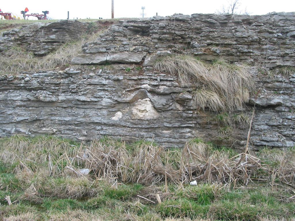
1 Stromatoporoids around the Georgetown, Kentucky area If you have ever visited and / or travelled around the area of Georgetown, Scott County, Kentucky you might have noted white watermelon shaped rocks exposed in road cuts, that seem to be out of place with the thinly bedded limestone that predominates the Central Kentucky Bluegrass area. You may even possibly travel the same route going to work every day and not pay any attention to the rocks exposed in road cuts along your route. There are many geological features exposed in the road cuts along Kentucky s roads that have stories to tell to the trained observer. The large white rocks of the Georgetown area are called stromatoporoids. The stromatoporoids are presumed to be the fossils of a sponge-like animal. The fossilized stromatoporoids in the Georgetown area are found associated with Ordovician age ( million years before present time) thinly bedded limestone of the Tanglewood Limestone Member of the Lexington Limestone. According to the U.S. Geological Survey Geologic Map of the Georgetown Quadrangle, Scott and Fayette Counties, Kentucky (Cressman, 1967) the Tanglewood Limestone Member is described as slightly phosphatic, light- to medium-gray to medium-brownish-gray, fine- to coarse-grained, bioclastic, generally well-sorted; in even beds and crossbedded sets mostly 0.5 to 1 foot thick. Two zones of stromatoporoids are identified as being present in the Tanglewood Limestone Member. The upper stromatoporoid zone occurs about 35 feet below the base of the overlying Millersburg Member of the Lexington Limestone and the lower zone occurs about 10 feet below the upper stromatoporoid zone. Taha and others (2001) have identified the stromatoporoid zone as being part of the Stamping Ground Member of the Middle Ordovician upper Lexington Limestone. The Stamping Ground Member is described by Taha and others (2001) as a 3-4 meter thick package of interbedded shale and limestone locally containing abundant stromatoporoids of the species Labechia huronensis. The Stamping Ground commences with shaly, nodular wackstones and coarsens upward to a thick grainstone. The Stamping Ground Member has been identified by geological mapping in parts of the Midway (Pomeroy, 1970), Georgetown (Cressman, 1967) and Centerville (Kanizay and Cressman, 1967) 7.5-minute quadrangles. The stratigraphy of the Stamping Ground Member has been described by Cressman in the Lithostratigraphy and Depositional Environments of the Lexington Limestone (Ordovician) of Central Kentucky (U.S.G.S. Professional Paper 768, 1973). Cressman identifies the Stamping Ground Member as a localized unit of the Lexington Limestone within the Tanglewood Limestone Member, with the type section identified in a rock quarry located on the north side of the Switzer-Stamping Ground Road, 2,700 feet west of its intersection with U.S. Highway 227, Scott County, Kentucky. There are a series of road cuts along McClelland Circle (U.S. Highway 62 / 460) near the intersection with Lexington Road (U.S. Highway 25) in Georgetown that have good exposures of stromatoporoid fossils. McClelland Circle is a by-pass around the southern side of the City of Georgetown that connects at Cherry Blossom Way to the east and ends at Frankfort Road (U.S. Highway 460) to the west. The series of road cuts is approximately one-half mile in overall length with the eastern end of the exposure at Latitude 38 degrees 11 minutes and 05.6 seconds / Longitude 84 degrees 33 minutes and 15.9 seconds (near the former Wal-Mart shopping Center) and western end of the exposure at Latitude 38 degrees 10
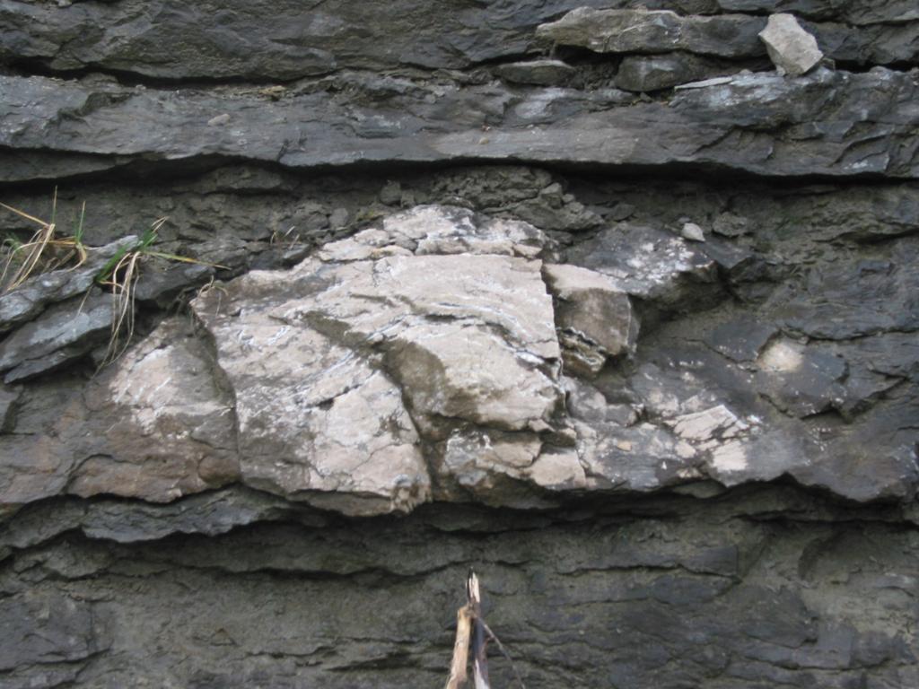
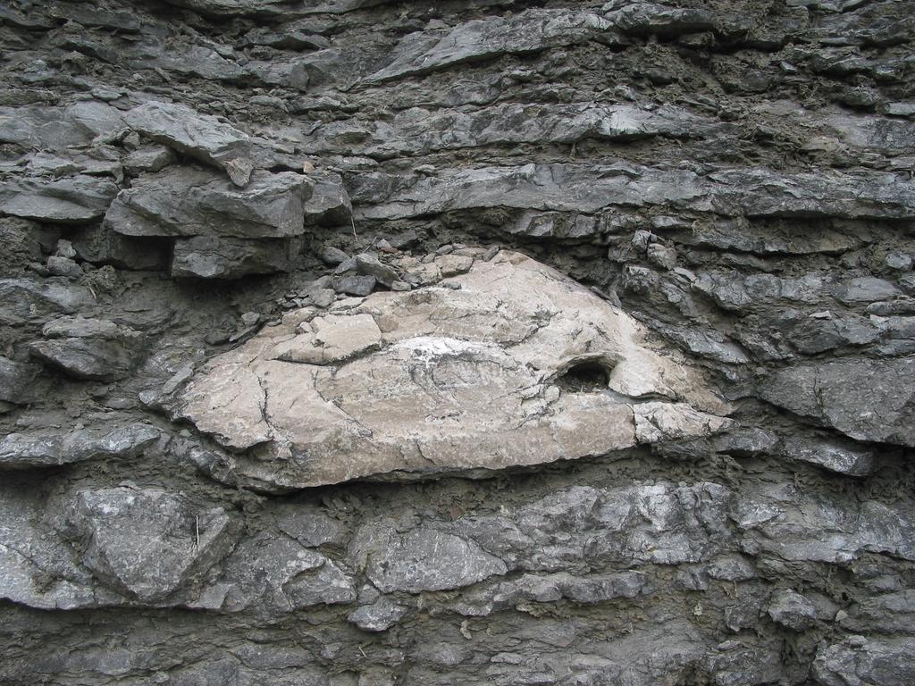
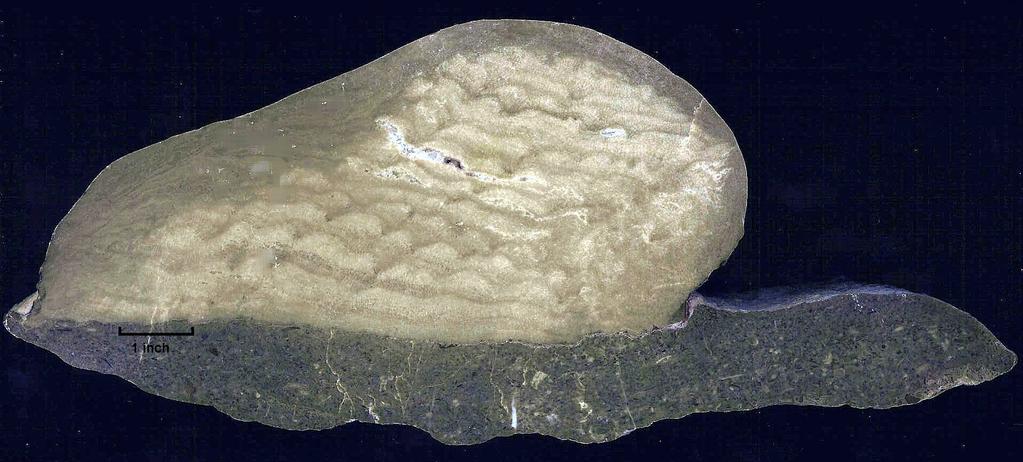
2 minutes and 58.0 seconds / Longitude 84 degrees 33 minutes and 56.2 seconds. The highest of the road cuts is approximately 20 feet with the stromatoporoid zone easily visible at about 5-10 feet above road level. Stromatoporoid fossils have been identified in carbonate sedimentary deposits from the Cambrian to the Oligocene and were until recently believed to be extinct. Stromatoporoids were reef forming organisms. It can therefore be concluded that water levels during deposition of Tanglewood Limestone Member were relatively shallow. Upon close inspection of a stromatoporoid one can see numerous thin stacked parallel layers. The layers formed by the secretion of a calcareous skeleton as the sponge-like animal grew and can be looked at as similar to annual growth rings found in tree trunks. According to the Glossary of Geology (Bates and Jackson, 1980) the internal structural elements are normally arranged sub-horizontally or as concentric laminae or lines separated by small radial pillars. The McClelland Circle road cuts are located within the Royal Springs ground water recharge area. Royal Springs is the source of drinking water for a large part of the Georgetown area. Surface water resulting from rain and snow infiltrates through fractures in the predominantly limestone bedrock and flows to Royal Springs, where it again becomes surface water. The McClelland Circle road cuts are not the only location where stromatoporoid fossils can be found in the Central Kentucky area. See if you can identify other exposures of the Stamping Ground Member of the Ordovician age Lexington Limestone. References Cressman, E.R., 1967, Geologic Map of the Georgetown Quadrangle, Scott and Fayette Counties, Kentucky. U.S. Geological Survey, Map GQ-605. Cressman, E.R., 1973, Lithostatigraphy and Depositional Environments of the Lexington Limestone (Ordovician) of Central Kentucky. U.S. Geological Survey, Professional Paper 768. Kanizay, S.P., and Cressman, E.R., 1967, Geologic Map of the Centerville Quadrangle, Central Kentucky. U.S. Geological Survey, Map GQ-653. Pomeroy, J.S., 1970, Geologic Map of the Midway Quadrangle, Central Kentucky. U.S. Geological Survey, Map GQ-856. Sparks, T.N., Dever, G.R., Jr., and Anderson, W.H., 2002, Geologic Map of the Lexington 30 x 60 minute Quadrangle, Central Kentucky (scale 1: 100,000), Kentucky Geological Survey Geologic Map Series , Lexington, Ky., 1 page. Georgetown Quadrangle, Kentucky, 7.5 Minute Series (Topographic), U.S. Geological Survey, 1965, revised Bates, R.L. and Jackson, J.A., editors, 1980, Glossary of Geology, second edition, American Geological Institute, Falls Church, Va.
3 Taha, S.L., Brett, C.E., McLaughlin, P.I., Krause, R.A. and Hudson, T.W., 2001, North-Central Section Geological Society of America, 35 th Annual Meeting, Illinois State University. Photograph Credits Aerial photographic imagery of Georgetown road cuts obtained from Ground level photographs of road cut and stromatoporoids by Gil W. Cumbee, CPG, PG, Polished slabs of stromatoporoid courtesy of Patrick Gooding, Kentucky Geological Survey.

4
5
6
7
8
FRACTURE TRACES AND PRODUCTIVITY OF MUNICIPAL WELLS IN THE MADISON LIMESTONE, RAPID CITY, SOUTH DAKOTA
 Proceedings of the South Dakota Academy of Science, Vol. 87 (2008) 261 FRACTURE TRACES AND PRODUCTIVITY OF MUNICIPAL WELLS IN THE MADISON LIMESTONE, RAPID CITY, SOUTH DAKOTA Perry H. Rahn Department of
Precambrian, Banded Iron Formation (Negaunee Formation) along US-41/M28, south of Coon Lake, Baraga County, Michigan
 along US-41/M28, south of Coon Lake, Baraga County, Michigan") Precambrian, Banded Iron Formation (Negaunee Formation) along US-41/M28, south of Coon Lake, Baraga County, Michigan Written By: Steven D.J. Baumann G-122013-1A Banded Iron Formation on the north side
Precambrian, Banded Iron Formation (Negaunee Formation) along US-41/M28, south of Coon Lake, Baraga County, Michigan Written By: Steven D.J. Baumann G-122013-1A Banded Iron Formation on the north side
The Niagara Escarpment extends from western New York, through the GTA all the way up to Manitoulin Island and into Michigan and Wisconsin.
 is southern Ontario s most prominent topographic feature, extending more than 500 kilometres from western New York, through Niagara Falls and the western part of the Greater Toronto Area (GTA), and north
American Institute of Professional Geologists South Dakota Section
 American Institute of Professional Geologists South Dakota Section 2015 Field Trip Guide Deadwood Formation in the Black Hills of South Dakota and Frac Sand Potential Saturday, September 12, 2015 1 Field
Geotechnical Aspects of the Ohio River Bridges Project
 Geotechnical Aspects of the Ohio River Bridges Project Mark A. Litkenhus, PE Sr. Geotechnical Engineer Stephen H. Bickel, PE Sr. Geotechnical Engineer STGEC Ohio River Bridges at Louisville Geotechnical
Maine Geologic Facts and Localities October, Lobster Lake, Maine. Text by Robert G. Marvinney. Maine Geological Survey
 Maine Geologic Facts and Localities October, 1998 Lobster Lake, Maine 45 o 51 7.91 N, 69 o 30 53.88 W Text by Robert G. Marvinney, Department of Agriculture, Conservation & Forestry 1 Map by Introduction
Some Geological Features at Smalls Falls, Maine
 Maine Geologic Facts and Localities July, 2005 Some Geological Features at Smalls Falls, Maine 44 51 30.47 N, 70 30 58.74 W Text by Robert Marvinney, Department of Agriculture, Conservation & Forestry
Geology and Soils. Technical Memorandum
 Geology and Soils Technical Memorandum TO: FDOT FROM: HDR, Inc. DATE: February 2013 PROJECT: St Johns River Crossing FPID No: 208225-3-21-01 Clay, Duval, and St. Johns Counties; Florida Geology and soils
A Geological Tour of Tumbledown Mountain, Maine
 Maine Geologic Facts and Localities April, 1998 A Geological Tour of Tumbledown Mountain, Maine 44 45 3.21 N, 70 32 50.24 W Text by Robert G. Marvinney, Department of Agriculture, Conservation & Forestry
Field Trip 1 Tunnel Mill, Vernon, Indiana: Waldron Shale
 Geol G308 Paleontology and Geology of Indiana Name: Field Trip 1 Tunnel Mill, Vernon, Indiana: Waldron Shale On this trip we will visit Tunnel Mill, which is located just south of Vernon, Indiana in the
Cretaceous, Dakota Formation, Terra Cotta Member South Side of I-70, Salina County, Kansas
 Cretaceous, Dakota Formation, Terra Cotta Member South Side of I-70, Salina County, Kansas Written By: Steven D.J. Baumann G-102010-1A Outcrop looking southeast Photo taken by: Steven Baumann on 10-20-2010
MAPPING THE EARTH HOW DO YOU FIND A LOCATION ON THE EARTH?
 MAPPING THE EARTH HOW DO YOU FIND A LOCATION ON THE EARTH? UNIT TOPICS TOPIC 1: LATITUDE & LONGITUDE TOPIC 2: FIELD MAPS TOPIC 3: TOPOGRAPHIC MAPS TOPIC 4: NYS LANDSCAPES TOPIC 1: LATITUDE & LONGITUDE
Geological History of the Grand Canyon
 Geological History of the Grand Canyon For a copy of this assignment, print a copy of this web page. The Project Your job is to write a short paper that describes the geological history of the Grand Canyon
PRECAMBRIAN CRYSTALLINE AQUIFER (METAMORPHIC ROCKS)
") HAYWARD QUADRANGLE: Groundwater Production by Aquifer In the 56-square-mile area of the Hayward Quadrangle, groundwater is produced from metamorphic crystalline rocks of the Precambrian basement (in the
HAYWARD QUADRANGLE: Groundwater Production by Aquifer In the 56-square-mile area of the Hayward Quadrangle, groundwater is produced from metamorphic crystalline rocks of the Precambrian basement (in the
THE MAMMOTH "EARTHQUAKE FAULT" AND RELATED FEATURES IN MON0 COUNTY, CALIFORNIA* By H. BENIOFF and B. GUTENBERG
 THE MAMMOTH "EARTHQUAKE FAULT" AND RELATED FEATURES IN MON0 COUNTY, CALIFORNIA* By H. BENIOFF and B. GUTENBERG IN UNDERTAKING this work it was our intention to investigate the well-known "Earthquake Fault"
Sedimentology, Petrography, and Mineralogy of the Tallahatta Formation near the City of Meridian, Mississippi
 Sedimentology, Petrography, and Mineralogy of the Tallahatta Formation near the City of Meridian, Mississippi Kiana McFadden and Ezat Heydari Department of Physics, Atmospheric Sciences, and Geoscience,
Allagash Falls Geology
 Maine Geologic Facts and Localities September, 2005 46 o 57 0.13"N, 69 o 7 59.15"W Text by Robert Marvinney, Department of Agriculture, Conservation & Forestry 1 Photos by Kyle Marvinney Introduction The
LINGUAU DEPOSITION IN THE WOODBINE SANDS ALONG COPPERAS BRANCH, DENTON COUNTY. TEXAS: A STUDY IN MARINE SEDIMENTATION
 LINGUAU DEPOSITION IN THE WOODBINE SANDS ALONG COPPERAS BRANCH, DENTON COUNTY. TEXAS: A STUDY IN MARINE SEDIMENTATION Ellis W. Shuler and Olin M. Millican The lack of outcrops in three dimensions often
APPALACHIAN COLLUVIAL
 LANDSLIDE PROBLEMS ON APPALACHIAN COLLUVIAL SLOPES Geohazards in Transportation in the Appalachian Region Charleston, WV August 5 7, 2008 RICHARD E. GRAY DIGIOIA, GRAY & ASSOCIATES, LLC. 570 BEATTY ROAD
Seismic Reflection Imaging across the Johnson Ranch, Valley County, Idaho
 Seismic Reflection Imaging across the Johnson Ranch, Valley County, Idaho Report Prepared for the Skyline Corporation Lee M. Liberty Center for Geophysical Investigation of the Shallow Subsurface (CGISS)
Holocene evolution of Dahab coastline Gulf of Aqaba, Sinai Peninsula, Egypt 1
 Holocene evolution of Dahab coastline Gulf of Aqaba, Sinai Peninsula, Egypt 1 Magdy Torab* 2 * Prof. of Geomorphology, Department of Geography, Damanhour University, Egypt 3 E-mail: magdytorab@hotmail.com.
August 31, 2006 Embankment Failure Debris Flow at the Cascades Development Haywood County, North Carolina. Introduction. Findings
 August 31, 2006 Embankment Failure Debris Flow at the Cascades Development Haywood County, North Carolina Introduction North Carolina Geological Survey (NCGS) staff members visited the site of the August
In this lab, we will study and analyze geologic maps from a few regions, including the Grand Canyon, western Wyoming, and coastal California.
 Name: Lab Section: work in groups, but each person turns in his/her own GEOSCIENCE 001 LAB UNDERSTANDING GEOLOGIC MAPS Geologic maps are colorful and even beautiful, but they also contain an amazing amount
Marshall Shore Town Park, Liberty, Maine
 Maine Geologic Facts and Localities August, 2005 Marshall Shore Town Park, Liberty, Maine 44 22 33.04 N, 69 21 9.19 W Text by Henry N. Berry IV, Department of Agriculture, Conservation & Forestry 1 Introduction
High-resolution Sequence Stratigraphy of the Glauconitic Sandstone, Upper Mannville C Pool, Cessford Field: a Record of Evolving Accommodation
 Page No. 069-1 High-resolution Sequence Stratigraphy of the Glauconitic Sandstone, Upper Mannville C Pool, Cessford Field: a Record of Evolving Accommodation Thérèse Lynch* and John Hopkins, Department
N W Y 5T E. 32nd ANNUAL MEETING. HAMILTON COLLEGE CLINTON, NEW YORK MAY, 1960
 I I N W Y 5T E GE LO Ie L so IA ION 32nd ANNUAL MEETING. HAMILTON COLLEGE CLINTON, NEW YORK MAY, 1960 GUIDEBOOK FOR FIELD TRIPS 32nd Annual Meeting of the NEW YORK STATE GEOLOGICAL ASSOCIATION David Hawley
Big Rivers Electric Corporation Disposal of Coal Combustion Residuals (CCR) from Electric Utilities Final Rule CCR Impoundment Liner Assessment Report
 from Electric Utilities Final Rule CCR Impoundment Liner Assessment Report") Big Rivers Electric Corporation Disposal of Coal Combustion Residuals (CCR) from Electric Utilities Final Rule CCR Impoundment Liner Assessment Report CCR Surface Impoundment Information Name: Operator:
Big Rivers Electric Corporation Disposal of Coal Combustion Residuals (CCR) from Electric Utilities Final Rule CCR Impoundment Liner Assessment Report CCR Surface Impoundment Information Name: Operator:
UNDERSTANDING GEOLOGIC M APS
 Name: Lab Section: work in groups, but each person turns in his/her own GEOSCIENCE 001 L AB UNDERSTANDING GEOLOGIC M APS Geologic maps are colorful and even beautiful, but they also contain an amazing
Lower Skinner Valley Fill Sandstones: Attractive Exploration Targets on the Northeast Oklahoma Platform*
 Lower Skinner Valley Fill Sandstones: Attractive Exploration Targets on the Northeast Oklahoma Platform* By Jim Puckette 1 Search and Discovery Article #10050 (2003) *Adapted from presentation to Tulsa
HISTORY OF CONSTRUCTION FOR EXISTING CCR SURFACE IMPOUNDMENT PLANT GASTON ASH POND 40 CFR (c)(1)(i) (xii)
(1)(i) (xii)") HISTORY OF CONSTRUCTION FOR EXISTING CCR SURFACE IMPOUNDMENT PLANT GASTON ASH POND 40 CFR 257.73(c)(1)(i) (xii) (i) Site Name and Ownership Information: Site Name: E.C. Gaston Steam Plant Site Location:
HISTORY OF CONSTRUCTION FOR EXISTING CCR SURFACE IMPOUNDMENT PLANT GASTON ASH POND 40 CFR 257.73(c)(1)(i) (xii) (i) Site Name and Ownership Information: Site Name: E.C. Gaston Steam Plant Site Location:
Structural Geology of the Mountains
 Structural Geology of the Mountains Clinton R. Tippett Shell Canada Limited, Calgary, Alberta clinton.tippett@shell.ca INTRODUCTION The Southern Rocky Mountains of Canada (Figure 1) are made up of several
ADVENTURES IN WATER DEVELOPED BY LOUISVILLE WATER COMPANY
 ADVENTURES IN WATER DEVELOPED BY LOUISVILLE WATER COMPANY Tunneling for Water explains the science behind a first-of-its-kind project in the world! Louisville Water Company is the first water utility
Field Meeting Report: Coniston, led by Derek Leviston 18 th May 1986
 ISSN 1750-855X (Print) ISSN 1750-8568 (Online) Field Meeting Report: Coniston, led by Derek Leviston 18 th May 1986 Les Dolamore 1 DOLAMORE, L. (1987). Field Meeting Report: Carrock Fell, led by Derek
KRIS wsbssm. IBHiiilll
 KRIS wsbssm IBHiiilll Digitized by the Internet Archive in 2012 with funding from University of Illinois Urbana-Champaign http://archive.org/details/engineeringaspec34ekbl STATE OF ILLINOIS HENRY HORNER,
Cattaraugus Creek: A Story of Flowing Water and the Geology of the Channel It Flows Through Presentation to West Valley Citizen Task Force 4/27/16
 Cattaraugus Creek: A Story of Flowing Water and the Geology of the Channel It Flows Through Presentation to West Valley Citizen Task Force 4/27/16 Raymond C. Vaughan, Ph.D. What happens if you drop a
An Evaluation of Pavement Drainage Interstate 64, Rowan-Carter Counties
 Transportation Kentucky Transportation Center Research Report University of Kentucky Year 1984 An Evaluation of Pavement Drainage Interstate 64, Rowan-Carter Counties David L. Allen Herbert F. Southgate
Vantage/Columbia Basin Field Trip
 Geology 152 Name Vantage/Columbia Basin Field Trip The primary goal of this course is to help you see the Earth from a different perspective a geological one. To accomplish this goal you will be expected
Sedimentary Rocks Reading with Questions (Pg. 3-6) Scheme for Sedimentary Rock Identification Video (Mr. White s website) Questions (Pg.
 Scheme for Sedimentary Rock Identification Video (Mr. White s website) Questions (Pg.") Do At Least 2 Must Do All NAME: Kick Off Activity Comparing Sedimentary and Igneous Rocks (Pg. 2) The Foundation Sedimentary Rocks Reading with Questions (Pg. 3-6) Scheme for Sedimentary Rock Identification
Do At Least 2 Must Do All NAME: Kick Off Activity Comparing Sedimentary and Igneous Rocks (Pg. 2) The Foundation Sedimentary Rocks Reading with Questions (Pg. 3-6) Scheme for Sedimentary Rock Identification
Groundwater Sensitivity Regions of Kentucky
 Groundwater Sensitivity Regions of Kentucky by Kentucky Department for Environmental Protection Division of Water Groundwater Branch 1994 Interpreted by Joseph A. Ray James S. Webb Phillip W. O'dell Scale
Accepted for publication by Kentucky Section of the American Institute of Professional Geologists
 August 25, 2016 Relationships between surface and ground water velocities determined from dye trace experiments in McConnell Springs and Preston s Cave Spring, Lexington, Fayette County, Kentucky Laura
THE BEDROCK SURFACE AND FORMER DRAINAGE SYSTEMS OF MONTGOMERY COUNTY, OHIO 1
 THE BEDROCK SURFACE AND FORMER DRAINAGE SYSTEMS OF MONTGOMERY COUNTY, OHIO 1 STANLEY E. NORRIS, Geologist, U. S. Geological Survey, Columbus, Ohio INTRODUCTION The bedrock surface of Montgomery County,
Field trip to Racine Reef Complex, Thornton Quarry, Illinois
 Field trip to Racine Reef Complex, Thornton Quarry, Illinois Primary objectives for this fieldtrip 1) Collect and identify the fossils of the Racine Reef Complex. 2) Discuss procedures for collecting fossil
AN APPLICATION OF ACID BASE ACCOUNTING FOR HIGHWAY CONSTRUCTION IN EAST TENNESSEE 1
 AN APPLICATION OF ACID BASE ACCOUNTING FOR HIGHWAY CONSTRUCTION IN EAST TENNESSEE 1 by J.T. Ammons C.B. Coburn, Jr. P.A. Shelton 2 Abstract. Concern over the environmental impact of highway construction
THE DEVONIAN SECTION NEAR ALTOONA, PENNSYLVANIA'
 THE DEVONIAN SECTION NEAR ALTOONA, PENNSYLVANIA' CHARLES BUTTS United States Geological Survey, Washington, D. C. STRATIGRAPHY Introduction.-This joint article has grown out of work done in connection
1 Hfli. ^^Hi. 11 mw\i. mmsisi i lull I. IMMRrtHttiifHmiititlK. RibWh. llml ''.' 1 ffililsiillsll8 ill. iiiinitsim IK«
 l i. :,, v. i :! 1.» r =,
DOLOMITE FROM THE MIDDLE ORDOVICIAN OF THE OSLO REGION
 ORSK GEOLOGISK TISSKRIFT 44 OLOMITE FROM THE MILE OROVICIAN OF THE OSLO REGION BY PER JøRGENSEN and NILS SPJELNÆS (Institutt for geologi, Blindern, Oslo, orway) The Cambro-Silurian carbonate rocks of the
Devil s Punchbowl -Virtual Field Trip-
 Devil s Punchbowl -Virtual Field Trip- School of GEOGRAPHY & GEOLOGY Carolyn Eyles & Susan Vajoczki Prepared by Zachary Windus and Liz Kenny From McMaster University take Main Street West towards Ancaster.
Groundwater Hydrology
 EXERCISE 12 Groundwater Hydrology INTRODUCTION Groundwater is an important component of the hydrologic cycle. It feeds lakes, rivers, wetlands, and reservoirs; it supplies water for domestic, municipal,
NAME DATE TOPOGRAPHIC MAPS. Activity 1: Topographic Map Investigation I: More Than a Road Map
 NAME DATE PARTNER(S) TOPOGRAPHIC MAPS Now you have seen how topographic maps can be generated to present the elevation of a terrain. Let s look at some topographic maps and learn how to interpret them.
Soils, Hydrogeology, and Aquifer Properties. Philip B. Bedient 2006 Rice University
 Soils, Hydrogeology, and Aquifer Properties Philip B. Bedient 2006 Rice University Charbeneau, 2000. Basin Hydrologic Cycle Global Water Supply Distribution 3% of earth s water is fresh - 97% oceans 1%
Road Scholar. Williamette Valley Invitational Practice Tournament
 Road Scholar Williamette Valley Invitational Practice Tournament Rules for this Event As you complete this event, enter your answers on the online data sheet. You may click "submit" when done and quietly
The Bedrock Geology of Mount Battie, Camden, Maine
 Maine Geologic Facts and Localities July, 2001, Maine 44 13 15.40 N, 69 4 5.10 W Text by Henry N. Berry IV, Department of Agriculture, Conservation & Forestry 1 Photo by Henry N. Berry IV Introduction
Cuyama Basin North Fork Vineyard
 Cuyama Basin North Fork Vineyard Company Background plus Data Insights to Support GSP Development for the Cuyama Basin Presented by Grapevine Capital Partners and Cleath-Harris Geologists April 26th, 2018
The Geology of Two Lights State Park. Cape Elizabeth, Maine
 Maine Geologic Facts and Localities June, 2002 Cape Elizabeth, Maine 43 33 33.48 N, 70 12 13.32 W Text by Henry N. Berry IV and Robert G. Marvinney, Department of Agriculture, Conservation & Forestry 1
Last Updated HYDROLOGIC ATLAS OF THE BLACK HILLS, PENNINGTON COUNTY, SOUTH DAKOTA
 Last Updated 10-29-2015 HYDROLOGIC ATLAS OF THE BLACK HILLS, PENNINGTON COUNTY, SOUTH DAKOTA INTRODUCTION The following is a brief outline of ground water characteristics in Pennington County, South Dakota.
GEOLOGY MEDIA SUITE Chapter 8
 UNDERSTANDING EARTH, SIXTH EDITION GROTZINGER JORDAN GEOLOGY MEDIA SUITE Chapter 8 Clocks in Rocks Timing the Geologic Record 2010 W.H. Freeman and Company Stratigraphy and fossils Figure 8.4 (page 172)
Fossils and Geology of Litzsinger Road Ecology Center
 Fossils and Geology of Litzsinger Road Ecology Center Table of Content Key Terms 1 Key Terms 2 What you need to know Geologic Map of Missouri Geologic Time Chart More of what you need to know Digital map
N. J. Macala. C ONTENT S. LIST OF PLATES.
 REPORT ON WATER SUikLY AT MANBULLOO STATION, NORTHERN TERRITORY. by N. J. Macala. Records 1957/62. C ONTENT S. Page. Introduction. 1. General Geology, 1. Hydrology. 1. New Bore Sites Selected. 2. Reference.
11/22/2010. Groundwater in Unconsolidated Deposits. Alluvial (fluvial) deposits. - consist of gravel, sand, silt and clay
 deposits. - consist of gravel, sand, silt and clay") Groundwater in Unconsolidated Deposits Alluvial (fluvial) deposits - consist of gravel, sand, silt and clay - laid down by physical processes in rivers and flood plains - major sources for water supplies
Groundwater in Unconsolidated Deposits Alluvial (fluvial) deposits - consist of gravel, sand, silt and clay - laid down by physical processes in rivers and flood plains - major sources for water supplies
2 Mapping Earth Reading Essentials. 2. Contrast What is the difference between a map view and a profile view?
 Mapping Earth Maps What do you think? Read the three statements below and decide whether you agree or disagree with them. Place an A in the Before column if you agree with the statement or a D if you disagree.
Sand. Sand is any eroded material (igneous, metamorphic or sedimentary) that has a grain size from 1/16 th to 2 millimeters in size.
 that has a grain size from 1/16 th to 2 millimeters in size.") Sedimentology 001 What is sedimentology? Sedimentology...encompasses the study of modern sediments such as sand [1], mud (silt) [2] andclay [3] and understanding the processes that deposit them.[4] It
Sedimentology 001 What is sedimentology? Sedimentology...encompasses the study of modern sediments such as sand [1], mud (silt) [2] andclay [3] and understanding the processes that deposit them.[4] It
Evolution of the conceptual hydrogeologic and ground-water flow model for Las Vegas Valley, Clark County, Nevada
 Evolution of the conceptual hydrogeologic and ground-water flow model for Las Vegas Valley, Clark County, Nevada Geological Society of America Annual Meeting November 14, 2 David J. Donovan Southern Nevada
GEOLOGY OF TODMORDEN MOOR 2 BACKGROUND
 GEOLOGY OF TODMORDEN MOOR 2 BACKGROUND 1) THE CARBONIFEROUS SERIES OF ROCKS The rocks of the Todmorden district are of the Carboniferous Series and were first laid down in an ancient sea, which covered
GEOL.3250 Geology for Engineers Sedimentary & Metamorphic Rocks
 GEOL.3250 Geology for Engineers Sedimentary & Metamorphic Rocks Name I. Introduction The bulk of the earth's crust is composed of relatively few minerals. These can be mixed together, however, to give
 http://dx.doi.org/10/1061/40698(2003)19 Green, J., Pavlish, J., Leete, J., and Alexander, Jr., E. (2003) Quarrying Impacts on Groundwater Flow Paths. Sinkholes and the Engineering and Environmental Impacts
Meters N 13 MUD HILLS. Kilometers
 1 0 1-8 1 10 9 1 1 11 9 0 Meters 17 1 7 8 0 18 19 1 N 1 MUD HILLS Kilometers 0 FIG. S1. Location of measured sections in the Mud Hills. Colors indicate facies association, as in Figure. Sections 0,,, 7
Although most karstic regions
 Urban Geophysics: Geophysical Signature of Mount Bonnell Fault and Its Karstic Features in Austin, TX by Mustafa Saribudak, Environmental Geophysics Associates, Austin, TX Although most karstic regions
Tanyard Creek Virtual Field Trip
 Tanyard Creek Virtual Field Trip NorthWest Arkansas Community College s GEOL 1114 Hybrid Instructor Dr. Wendi J. Williams Student Team Members Cynthia Brantley Cassie Harris Jonathan Mooney David Selby
APPENDIX A GLOSSARY. Appendix A.1
 APPENDIX A GLOSSARY Appendix A.1 Appendix A.2 Back Bearing A back bearing is measured from the object to your position. It is the exact opposite of a direct bearing. Base Line An imaginary line on the
Lunar Exploration Initiative
 Briefing Topic: Expanding BPLF Activity to the West David A. Kring November 2008 Contents: Regional Geologic Context 2 Location of Desert RATS 2008-2009 Activities 10 Potential Expansion of Test Area to
REPORT OF GEOPHYSICAL SURVEY
 REPORT OF GEOPHYSICAL SURVEY KARST IMAGING STUDY CADIZ INDUSTRIAL PARK CADIZ, TRIGG COUNTY, KY MUNDELL PROJECT NO. M NOVEMBER, South Downey Avenue, Indianapolis, Indiana - Telephone --, Facsimile -- www.mundellassociates.com
Cambrian and Early Ordovician Stratigraphy and Paleontology of the Basin and Range Province, Western United States
 Cambrian and Early Ordovician Stratigraphy and Paleontology of the Basin and Range Province, Western United States Las Vegas, Nevada to Salt Lake City, Utah July 1-7, 1989 Field Trip Guidebook T125 Leader:
GSA DATA REPOSITORY
 GSA DATA REPOSITORY 2015274 Saltzman "Persistent oceanic anoxia..." Part I. NOTES ON CAMBRO-ORDOVICIAN CARBON ISOTOPE COMPOSITE CURVE IN FIG. 1 CAMBRIAN COMPOSITE REFERENCES FOR FIG.1 Data all originally
Geologic Considerations of Shallow SAGD Caprock; Seal Capacity, Seal Geometry and Seal Integrity, Athabasca Oilsands, Alberta Canada
 Geologic Considerations of Shallow SAGD Caprock; Seal Capacity, Seal Geometry and Seal Integrity, Athabasca Oilsands, Alberta Canada Gordon T. Stabb, Michael Webb Durando Resources Corp, Suncor Energy
Seismic Data and Drilling in Hancock Co., Kentucky February 21, 2008
 Seismic Data and Drilling in Hancock Co., Kentucky February 21, 2008 J.A. Drahovzal 2/21/08 1 Hancock County (H1) Information Provided at 2/7/08 Meeting Depth of Top (t) and Thickness (th) in feet t Kn
Follow this and additional works at: Part of the Geology Commons
 Western Michigan University ScholarWorks at WMU Michigan Geological Repository for Research and Education Geosciences 2016 Geology of Michigan William B. Harrison III Michigan Geological Repository for
Using Map and Compass Together
 Using Map and Compass Together In situations where you foresee a potential evacuation on foot, where there are no roads, and no indication as to the direction of travel (i.e., road signs), it is recommended
Geology 101 Lab Worksheet: Topographic Maps
 Geology 101 Lab Worksheet: Topographic Maps Name: Refer to the Topographic Maps Lab for the information you need to complete this worksheet (http://commons.wvc.edu/rdawes/g101ocl/labs/topomapslab.html).
Class Notes: Mapping the Earth
 Name: Date: Period: Mapping the Earth The Physical Setting: Earth Science Class Notes: Mapping the Earth I. Latitude and Longitude Map -! Latitude -! Also called These lines intersect Equator -! The North
Florida s Karst Geology
 Florida s Karst Geology Orange Creek Basin Interagency Working Group Public Workshop, November 5 th, 2015 Harley Means, P.G. Assistant State Geologist Florida Geological Survey Karst Karst a type of topography
Later Mississippian. Sun, seas, and reefs
 Later Mississippian Sun, seas, and reefs P. David Polly Department of Geological Sciences Indiana University Bloomington, Indiana 47405 USA pdpolly@indiana.edu Bahama Banks Space shuttle photo by Chris
The Geology of the Marginal Way, Ogunquit, Maine
 Maine Geologic Facts and Localities February, 2002 The Geology of the Marginal Way, Ogunquit, Maine 43 14 23.88 N, 70 35 18.36 W Text by Arthur M. Hussey II, Bowdoin College and Robert G. Marvinney,, Department
1. Base your answer to the following question on The diagram below represents a part of the crystal structure of the mineral kaolinite.
 1. Base your answer to the following question on The diagram below represents a part of the crystal structure of the mineral kaolinite. An arrangement of atoms such as the one shown in the diagram determines
Sedimentary Rocks, our most Valuable Rocks. Or, what you will probably find when you are outdoors exploring.
 Sedimentary Rocks, our most Valuable Rocks Or, what you will probably find when you are outdoors exploring. Sedimentary rocks give us evidence to earth s earlier history. We look at processes happening
R ENW Services - Geophysics & GIS
 Yankton Block 1 Vermillion Block 2 N 2 0 1 Block 3 Elk Point 2 3 4 5 6 MILES Block 4 R20-2002-01 0 1 2 3 4 5 6 7 8 9 10 KILOMETERS Block 5 Figure courtesy of ENW Services - Geophysics & GIS Block 6 Test
Sediment and sedimentary rocks Sediment
 Sediment and sedimentary rocks Sediment From sediments to sedimentary rocks (transportation, deposition, preservation and lithification) Types of sedimentary rocks (clastic, chemical and organic) Sedimentary
Seismic tests at Southern Ute Nation coal fire site
 Seismic tests at Southern Ute Nation coal fire site Sjoerd de Ridder and Seth S. Haines ABSTRACT We conducted a near surface seismic test at the Southern Ute Nation coal fire site near Durango, CO. The
Formation Stratigraphy and Interfingering at the Port of Miami
 Formation Stratigraphy and Interfingering at the Port of Miami AUGUST 6, 2012 PROJECT PARTNERS Public Sponsors 90% Equity Partner Contractor 10% Equity Partner VMS Operator Federal Support FUNDING PARTNERS
Facies Analysis and Depositional Environments of Khabour Formation/ from Iraqi Kurdistan Region Northern Iraq
 Facies Analysis and Depositional Environments of Khabour Formation/ from Iraqi Kurdistan Region Northern Iraq By Dr.Muhamed F. Omer Assistant Professor of Sedimentology Salahaddin University- Science College
Cape Breton Island Mineral Inventory Studies: A Sandstone Quarry Development Opportunity at Graham River (NTS 11F/14), Inverness County
, Inverness County") Report of Activities 2001 23 Cape Breton Island Mineral Inventory Studies: A Sandstone Quarry Development Opportunity at Graham River (NTS 11F/14), Inverness County G. J. DeMont and J. E. Hawken Compilation
Report of Activities 2001 23 Cape Breton Island Mineral Inventory Studies: A Sandstone Quarry Development Opportunity at Graham River (NTS 11F/14), Inverness County G. J. DeMont and J. E. Hawken Compilation
Assignment Discovery Online Curriculum. Lesson title: Unique Landforms. Grade level: 3-4. Duration: Two class periods
 Assignment Discovery Online Curriculum Lesson title: Unique Landforms Grade level: 3-4 Duration: Two class periods Objectives: Students will do the following: Learn how water and erosion affect the landscape
This material is part of the collection of the Philadelphia Water Department and was downloaded from the website Please contact the
 This material is part of the collection of the Philadelphia Water Department and was downloaded from the website www.phillyh2o.org Please contact the PhillyH2O webmaster for more information about this
4 Sedimentary phosphate deposits 4.1 Introduction
 4 Sedimentary phosphate deposits 4.1 Introduction Sedimentary phosphate deposits or phosphorites contain few percents of calcium phosphate in form of grains of apatite, bone fragments or coprolites, and
Section 7. Reading the Geologic History of Your Community. What Do You See? Think About It. Investigate. Learning Outcomes
 Chapter 3 Minerals, Rocks, and Structures Section 7 Reading the Geologic History of Your Community What Do You See? Learning Outcomes In this section, you will Goals Text Learning Outcomes In this section,
Subsurface Geology of the Kennebec River
 Maine Geologic Facts and Localities July, 1998 Subsurface Geology of the Kennebec River 43 54 40.75 N, 69 48 29.01 W Text by Daniel B. Locke, Department of Agriculture, Conservation & Forestry 1 Map by
P.R. SPRING AND HILL CREEK TAR SAND AREAS A RESOURCE ASSESSMENT (IN PROGRESS)
") P.R. SPRING AND HILL CREEK TAR SAND AREAS A RESOURCE ASSESSMENT (IN PROGRESS) presented by WALLY GWYNN - Utah Geological Survey at the Western U.S. Oil Sands Technology Transfer Meeting February 22, 2008
P.R. SPRING AND HILL CREEK TAR SAND AREAS A RESOURCE ASSESSMENT (IN PROGRESS) presented by WALLY GWYNN - Utah Geological Survey at the Western U.S. Oil Sands Technology Transfer Meeting February 22, 2008
Dye Trace Study of Karst Groundwater Flow at Mystery Spring and Wildcat Culvert in Lexington, Fayette County, Kentucky
 Nýsa, The NKU Journal of Student Research Volume 1 Fall 2018 Dye Trace Study of Karst Groundwater Flow at Mystery Spring and Wildcat Culvert in Lexington, Fayette County, Kentucky Daniel P. Martin will
Jasper Beach, Machiasport, Maine
 Maine Geologic Facts and Localities June, 2000 Jasper Beach, Machiasport, Maine 44 o 38 30.28 N, 67 o 22 31.96 W Text by Joesph T. Kelley, Department of Agriculture, Conservation & Forestry 1 Map by USGS
Burrow-Mottled Carbonates in the Devonian Wabamun Formation, Pine Creek Gas Field, Alberta, Canada
 Page No. 142-1 Burrow-Mottled Carbonates in the Devonian Wabamun Formation, Pine Creek Gas Field, Alberta, Canada Gladys Fong Department of Earth and Atmospheric Sciences University of Alberta, Edmonton,