Randall W. Parkinson, Ph.D., P.G. Institute of Water and Environment Florida International University
|
|
|
- Albert Price
- 5 years ago
- Views:
Transcription

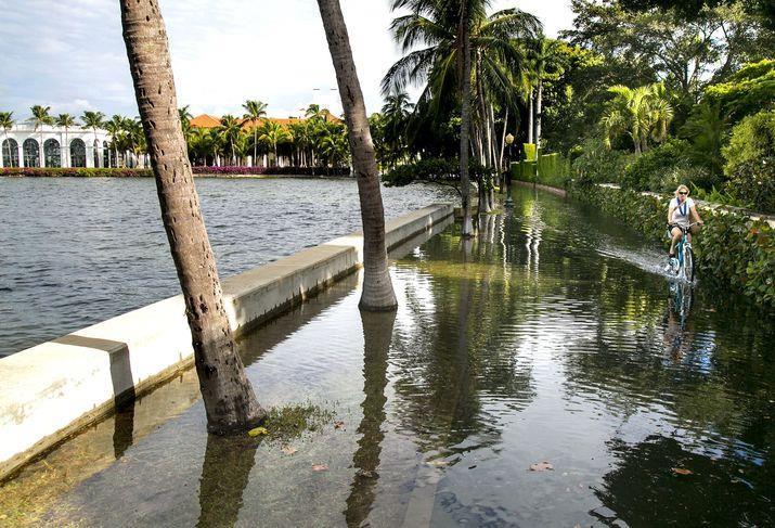
1 An Update on Adaptation Action Activities Undertaken Since Completion of the City of Satellite Beach (FL) Vulnerability Assessment to Rising Seas (2010) Randall W. Parkinson, Ph.D., P.G. Institute of Water and Environment Florida International University Western edge of the City of Satellite Beach is only a few feet above water

2 2.5 m ~3.4 mm/yr 0.5 m <1 mm/yr


3 Tamarac Miami Beach Ft. Lauderdale Palm Beach South Florida nuisance flooding during September/October 2015 supermoon events
4 Severely eroding Moderately eroding Relatively stable Severely eroding Moderately eroding Relatively stable All 30 coastal states have experienced moderate to severe erosion during the last century. USCCSP 2009
 of Florida's critically eroding beaches has almost doubled over past 25")
5 Year Critical erosion Non-critical erosion Length (miles) of Florida's critically eroding beaches has almost doubled over past 25 years source: FDEP 2015


6 City of Satellite Beach, Florida S. Patrick Dr. Highway A1A Cape Canaveral Grand Canal Atlantic Ocean Samsons Island Brevard County, Florida Banana River Width of photo is 2.5 km or 1.5 miles

7 Elevation (ft - MWL) Grand Canal S. Patrick Dr. Highway A1A Atlantic Ocean Grand Canal South Patrick Dr Topographic Profile from Banana River to Atlantic Ocean Distance from Banana River Shoreline (miles) Barrier Island Elevation (Topography)
8 City limit 5% of the City is flooded by a 2 ft rise in sea level. Atlantic Ocean

9 City limit 25% of the City is flooded by a 4 ft rise in sea level. Atlantic Ocean
10 City limit 50% of the City is flooded by a 6 ft rise in sea level. Atlantic Ocean

11 The City of Satellite Beach Sea Level Rise Subcommittee and thereafter the Comprehensive Planning Advisory Board recommended the City Council make changes to their Comprehensive Plan in 2010.
12 Example of changes proposed to the City s Comprehensive Plan in 2010 Future Land Use Policy The City shall continue to monitor zoning regulations pertaining to land east of the Coastal Construction Control Line (CCCL) and enact regulations to achieve a balance of among economic feasibility, potential adverse environmental conditions, and limitation of development in the Coastal High Hazard Area (CHHA) sustainability consistent with the character of the City. Policy 1.2.9a - Post-disaster redevelopment shall be governed by all applicable codes, city charter provisions and standards, in regards to setbacks, off-street parking, and landscaping; and shall decrease future public and private vulnerability to future storms by complying with applicable state and county construction regulations and sea level rise.
 and SLR policies.")
13 ?! In March 2013, after nearly three years of debate and revision, the City Council approved amendments to the Coastal Element of their Comprehensive Plan. The focal point of these changes was the establishment of Adaptation Action Areas (AAA) and SLR policies.
14 The Coastal Element of the City s Comp Plan now includes an Adaptation Action Area (AAA) policy designed to: Reduce exposure of human life and property to natural hazards while reducing the cost of flood insurance Permit (re)development only when it shall protect life and property from the effects of coastal erosion, flooding, sea level rise, and damage to environmental systems
15 What s happened since adoption of a AAA policy in 2013? In 2014, FDEP awarded a Coastal Partnership Community Resiliency Grant to the East Central Florida Regional Planning Council that was completed in Project goals included: Identify vulnerable lands that could be included in a AAA Engage the public to help set priorities to increase natural hazard resilience
 Coastal Erosion (FDEP) Storm Surge (NOAA) Flooding (FEMA) Sea Level Rise (in-house) Source:")
16 DEP Coastal Partnership Community Resiliency Grant Goal: Identify vulnerable lands that could be included in a AAA (in progress) Coastal Erosion (FDEP) Storm Surge (NOAA) Flooding (FEMA) Sea Level Rise (in-house) Source: ECFRPC
, resident priorities included (higher to lower priority): 1. Loss of Power/Utilities during storms 2. Coastal Erosion 3. Storm Surge 4. Flooding 5.")
17 DEP Coastal Partnership Community Resiliency Grant Goal: Engage the public to help set priorities increase resilience (completed) Based upon stakeholder input during public events, workshops, and ultimately an on-line survey (Metroquest), resident priorities included (higher to lower priority): 1. Loss of Power/Utilities during storms 2. Coastal Erosion 3. Storm Surge 4. Flooding 5. Sea Level Rise 6. Do Nothing
18 Other Actions 1. Established a Sustainability Board..to create more sustainable, environmentally-friendly neighborhoods by reducing consumption and waste, protecting our environmental assets and accommodating hazards associated with our vulnerable coastal location. (2015) 2. Completed an initial sustainability assessment report to create a starting point or benchmark to measure long term performance of city sustainability initiatives. (2015) 3. Refining select infrastructure maps and metadata (2016) Delineating building footprints and first floor elevations to facilitate more accurate flood damage assessments Updating stormwater conveyance data to facilitate planning and capital improvements to vulnerable infrastructure
19 In summary: Over the past 8 years, here has been significant progress since completion of the City s initial vulnerability assessment that began in Comprehensive Plan has been amended to include AAA policies Community education and outreach is helping identify and prioritize adaptation options Work currently underway to identify AAAs and refine the City s infrastructure database Created a Sustainability Board and completed baseline assessment All of these actions are designed to optimize resilience to natural hazards (i.e., erosion, flooding, SLR) under conditions of a changing climate. The final challenge will be to successfully complete and implement an adaptation action plan.

20 An Update on Adaptation Action Activities Undertaken Since Completion of the City of Satellite Beach (FL) Vulnerability Assessment to Rising Seas (2010) Randall W. Parkinson, Ph.D., P.G. Institute of Water and Environment Florida International University Thank you City of Satellite Beach, Florida, September 2014 after intense 2-yr rainfall event
Adapting to Rising Sea Level & Extreme Weather Events:
 Adapting to Rising Sea Level g & Extreme Weather Events: A Florida Perspective Randall W. Parkinson, Ph.D., P.G. President RWParkinson Consulting, Inc. Melbourne, Florida & Administrator Space Coast Climate
Application #: TEXT
 TOWN OF FORT MYERS BEACH 2008 PROPOSED COMPREHENSIVE PLAN AMENDMENTS Application #: 2008-13-TEXT Description: Modify the Coastal Management and Future Land Use Elements to reflect the state s new definition
Sea-Level Rise Impacts on South Florida
 Sea-Level Rise Impacts on South Florida Keren Prize Bolter, PhD Science Director, Coastal Risk Consulting. LLC 5/3/16 FAQ list What is happening? What impacts are we already seeing? Just how vulnerable
Planning for coastal hazards in a changing climate
 March 2013 Planning for coastal hazards in a changing climate Catherine Knight, Coastal and Estuary Officer Sharyn French, Manager Land and Natural Environment Presentation overview Stormy past Council
City of Manitou Springs
 March 2018 City of Manitou Springs Implementing Land Use tools to reduce and mitigate natural hazard risk Context & History Past Present Historic homes Older infrastructure Hillside development Creekside
Sea Level Rise Study Summary Town of South Bethany
 Sea Level Rise Study Summary Town of South Bethany This presentation was prepared by Anchor QEA for the Town of South Bethany using Federal Funds under award NA14 NOS 419 0123 from the Delaware Coastal
Background and Purpose of Meeting. River Towers Meeting. Flood Risk Management Study Alternatives Overview
 1 and Purpose of Meeting River Towers Meeting Flood Risk Management Study Alternatives Overview September 23, 2014 There is no "proposed" flood risk management solution for this area at this time Fairfax
Assessing Sea Level Rise, Storm Surge and Flooding Risks at the Ogunquit Wastewater Treatment Facility COMMITMENT & INTEGRITY DRIVE RESULTS
 Assessing Sea Level Rise, Storm Surge and Flooding Risks at the Ogunquit Wastewater Treatment Facility September 27, 2012 Presentation Outline Reasons for the Study Sea Level Rise, Storm Surge & Flooding
SOUTHEAST COASTAL ASSESSMENT: Creating a shared vision
 SOUTHEAST COASTAL ASSESSMENT: Creating a shared vision November 12, 2017 Jacqueline Keiser, PG, PMP Regional Sediment Management Regional Center of Expertise SOUTH ATLANTIC DIVISION U.S. ARMY CORPS OF
Sea-level Rise on Cape Cod: How Vulnerable Are We? Rob Thieler U.S. Geological Survey Woods Hole, MA
 Sea-level Rise on Cape Cod: How Vulnerable Are We? Rob Thieler U.S. Geological Survey Woods Hole, MA Outline Sea-level and coastal processes Past sea-level change Predictions for the future Coastal responses
Appendix C Fluvial Flood Hazards
 Appendix C Fluvial Flood Hazards Sea Level Rise Vulnerability Assessment and Adaptation Project March 2019 Contents Contents... i Figures... i Tables... i Definitions, Acronyms, & Abbreviations... ii
Preliminary Vulnerability Assessment of Coastal Flooding Threats - Taylor County, Florida
 Preliminary Vulnerability Assessment of Coastal Flooding Threats - Taylor County, Florida North Central Florida Regional Planning Council Northeast Florida Regional Council April 28, 2016 BACKGROUND This
Mapping of Future Coastal Hazards. for Southern California. January 7th, David Revell, Ph.D. E.
 Mapping of Future Coastal Hazards for Southern California January 7th, 2014 David Revell, Ph.D. drevell@esassoc.com E. Vandebroek, 2012 Outline Coastal erosion hazard zones Flood hazard zones: Coastal
3301 Rickenbacker Causeway, Miami, FL 33149
 Virginia Key and Miami Beach 2016 King Tide Report and Projections (to 2045) using: 3301 Rickenbacker Causeway, Miami, FL 33149 *THIS REPORT IS PROVIDED SUBJECT TO THE COASTAL RISK CONSULTING, LLC, PRINTED
Turn and Face the Strange: Economic Impacts of Climate Change Sea Level Rise and Coastal Flooding E2Tech Forum June 21, 2018
 Turn and Face the Strange: Economic Impacts of Climate Change Sea Level Rise and Coastal Flooding E2Tech Forum June 21, 2018 Peter A. Slovinsky, Marine Geologist Maine Geological Survey Image from Chebeague.org
Sri Lanka has a coastline of km excluding the shoreline of bays and inlets.
 Defining and Demarcating Coastal zones in Sri Lanka Procedure, Challenges and What needs to be done? Dr. Anil Premaratne Director General Coast Conservation Coast Conservation Department Sri Lanka 1 Sri
Florida Flood Risks. Heavy Rainfall. Groundwater. Tidal Flooding. Storm Surge. King Tides. Runoff/Riverine
 Florida Flood Risks Heavy Rainfall Storm Surge Groundwater Tidal Flooding Runoff/Riverine King Tides Sawgrass Mills Mall Sunrise, Florida 15 of rain in 3 days, with most in 24 hours. Mall closed for 3
Presentation Outline. Project Overview. Sea Level Rise Assessment & Decision Tools. Community Engagement. Tina Whitman, Friends of the San Juans
 Healthy Beaches for People & Fish Sea Level Rise Adaptation Tools for San Juan County, WA Tina Whitman & Andrea MacLennan December 10, 2015 Presentation Outline Project Overview Tina Whitman, Friends of
Uses of The Climate and Climate-related Hazard Information in The Adaptation Strategies for Development and Spatial Planning Assessments
 Uses of The Climate and Climate-related Hazard Information in The Adaptation Strategies for Development and Spatial Planning Assessments Wilmar Salim, ST., M. Reg. Dev., Ph.D. Yogyakarta Monday, March
Coastal Flood Risk Study Project for East Coast Central Florida Study Area
 Coastal Flood Risk Study Project for East Coast Central Florida Study Area St Lucie County, Florida Flood Risk Review Meeting March 28, 2017 Introductions Risk MAP Project Team FEMA Region IV BakerAECOM,
From Vulnerability to Resilience And the Tools to Get There. Out of Harm s Way Partnership for the Delaware Estuary August 1, 2012
 From Vulnerability to Resilience And the Tools to Get There Out of Harm s Way Partnership for the Delaware Estuary August 1, 2012 Today s Presentation Tour of New Jersey Challenges Definitions so we re
CLIMATE READY BOSTON. Climate Projections Consensus ADAPTED FROM THE BOSTON RESEARCH ADVISORY GROUP REPORT MAY 2016
 CLIMATE READY BOSTON Sasaki Steering Committee Meeting, March 28 nd, 2016 Climate Projections Consensus ADAPTED FROM THE BOSTON RESEARCH ADVISORY GROUP REPORT MAY 2016 WHAT S IN STORE FOR BOSTON S CLIMATE?
Draft for Discussion 11/11/2016
 Coastal Risk Consulting (CRC) Climate Vulnerability Assessment for Village of Key Biscayne Deliverable 1.1 in Statement of Work. Preliminary Vulnerability Assessment Identifying Flood Hotspots Introduction...
DELINEATION OF COASTAL SET-BACK LINES AND OVERLAY ZONES IN WEST COAST DISTRICT
 DELINEATION OF COASTAL SET-BACK LINES AND OVERLAY ZONES IN WEST COAST DISTRICT I. Bekko C. George IAIA Conference August 2014 Content Background and Context Process followed for West Coast District Set-back
Hurricane Wilma Post Storm Data Acquisition Estimated Peak Wind Analysis and Storm Tide Data. December 27, 2005
 Hurricane Wilma Post Storm Data Acquisition Estimated Peak Wind Analysis and Storm Tide Data December 27, 2005 Hurricane Wilma was the sixth major hurricane of the record-breaking 2005 Atlantic hurricane
Tony Pratt, DNREC to The Center for the Inland Bays Scientific and Technical Advisory Committee. August 21, 2009
 Sea Level Rise in Delaware Presented by Tony Pratt, DNREC to The Center for the Inland Bays Scientific and Technical Advisory Committee August 21, 2009 Sea level has been fluctuating ever since there have
Miami-Dade County Technical Update Meeting South Florida Coastal Study. May 11, 2016
 Miami-Dade County Technical Update Meeting South Florida Coastal Study May 11, 2016 Welcome and Introductions FEMA Region IV Christina Lindemer Technical Lead Production and Technical Services (PTS) Contractor
Delta Flood Protection Strategy Update. May 16, 2016
 Delta Flood Protection Strategy Update May 16, 2016 Presentation Overview 1. Background 2. Understanding the Dike Reaches/Issues 3. Future Dike Improvements 4. Next Steps Boundary Bay Village March 10,
Developed in Consultation with Florida Educators
 Developed in Consultation with Florida Educators Table of Contents Next Generation Sunshine State Standards Correlation Chart... 7 Benchmarks Chapter 1 The Practice of Science...................... 11
Oregon APA Legal Issues Workshop December 7, Tricia Sears, DLCD With information from Bill Burns, DOGAMI
 Oregon APA Legal Issues Workshop December 7, 2018 Tricia Sears, DLCD With information from Bill Burns, DOGAMI How this Topic Arrived WE FREQUENTLY HEAR CONCERNS ABOUT LIABILITY AND TAKINGS. Current federal
Climate Risk Visualization for Adaptation Planning and Emergency Response
 Climate Risk Visualization for Adaptation Planning and Emergency Response NCR Flood Fact Finding Workshop Ricardo Saavedra ricardo@vizonomy.com Social Media, Mobile, and Big Data St. Peter s Basilica,
Location: Jacksonville, FL December 11, 2012
 Technical Update Meeting Northeast Florida Surge Study Location: Jacksonville, FL December 11, 2012 Agenda 2:00 2:15 Welcome/Introductions Tucker Mahoney, FEMA Region IV Michael DelCharco, BakerAECOM 2:15
COASTAL DATA APPLICATION
 2015 Coastal GeoTools Proactive By Design. Our Company Commitment COASTAL DATA APPLICATION Projecting Future Coastal Flood Risk for Massachusetts Bay Bin Wang, Tianyi Liu, Daniel Stapleton & Michael Mobile
Climate Vulnerability Assessment (CVA) Localized Flooding & Extreme Heat Update
 Localized Flooding & Extreme Heat Update") Climate Vulnerability Assessment (CVA) Localized Flooding & Extreme Heat Update Metropolitan Council Land Use Advisory Committee 09/20/2018 Climate Vulnerability Assessment - Recap July 21, 2016 LUAC Presentation
Climate Vulnerability Assessment (CVA) Localized Flooding & Extreme Heat Update Metropolitan Council Land Use Advisory Committee 09/20/2018 Climate Vulnerability Assessment - Recap July 21, 2016 LUAC Presentation
Chapter 7 Mudflow Analysis
 Chapter 7 Mudflow Analysis 7.0 Introduction This chapter provides information on the potential and magnitude of mud floods and mudflows that may develop in Aspen due to rainfall events, snowmelt, or rain
The Impact of Hurricane Irma on the Coast of Florida
 The Impact of Hurricane Irma on the Coast of Florida Ralph Clark, Guy Weeks, Robert Wang, Mike Manausa & Peter Bacopoulos Division of Water Resource Management February 8, 2018 Overview: Hurricane Irma
DIVISION OF COASTAL MANAGEMENT TO STUDY CURRENT LONG-TERM EROSION RATES ADJACENT TO TERMINAL GROINS
 DIVISION OF COASTAL MANAGEMENT TO STUDY CURRENT LONG-TERM EROSION RATES ADJACENT TO TERMINAL GROINS North Carolina Department of Environmental Quality Division of Coastal Management February 22, 2018 N.
Risk-based land use and spatial planning
 Risk-based land use and spatial planning Miho OHARA International Centre for Water Hazards and Risk Management (ICHARM) Public Works Research Institute PWRI), Japan Under the auspices of UNESCO Introduction
Ground Water Protection Council 2017 Annual Forum Boston, Massachusetts. Ben Binder (303)
") Ground Water Protection Council 2017 Annual Forum Boston, Massachusetts Protecting Groundwater Sources from Flood Borne Contamination Ben Binder (303) 860-0600 Digital Design Group, Inc. The Problem Houston
Ground Water Protection Council 2017 Annual Forum Boston, Massachusetts Protecting Groundwater Sources from Flood Borne Contamination Ben Binder (303) 860-0600 Digital Design Group, Inc. The Problem Houston
Pequabuck River Flooding Study and Flood Mitigation Plan The City of Bristol and Towns of Plainville and Plymouth, CT
 Pequabuck River Flooding Study and Flood Mitigation Plan The City of Bristol and Towns of Plainville and Plymouth, CT Raymond Rogozinski and Maged Aboelata The City of Bristol and Towns of Plainville and
Storm Surge/Coastal Inundation State of the Union. Jamie Rhome Storm Surge Team Lead NOAA/National Hurricane Center
 Storm Surge/Coastal Inundation State of the Union Jamie Rhome Storm Surge Team Lead NOAA/National Hurricane Center 2 Tampa: Cat 5 Scenario 3 4 The Stakes are High Combination of SLR and increasing coastal
MODELING OF EROSION CONTROL ALTERNATIVES AT STUMP PASS, CHARLOTTE COUNTY
 2014 NATIONAL CONFERENCE ON BEACH PRESERVATION TECHNOLOGY FEBRUARY 13, 2014 MODELING OF EROSION CONTROL ALTERNATIVES AT STUMP PASS, CHARLOTTE COUNTY 1 VADIM ALYMOV, PH.D. 2 CHUCK MOPPS 3 MICHAEL POFF,
TFMA Spring Conference Houston, Texas March 10, 2016 PROJECT TEAM:
 TFMA Spring Conference Houston, Texas March 10, 2016 PROJECT TEAM: Brown, Leal & Associates R. Gutierrez Engineering ERO Architects Administered by the Texas Water Development Board History of the Study
Semi-enclosed seas. Estuaries are only a particular type of semi-enclosed seas which are influenced by tides and rivers
 Semi-enclosed seas Estuaries are only a particular type of semi-enclosed seas which are influenced by tides and rivers Other semi-enclosed seas vary from each other, mostly by topography: Separated from
Storm Surge Analysis Update Meeting Cross City, Florida June 17, 2014
 Big Bend Coastal Storm Surge Study Storm Surge Analysis Update Meeting Cross City, Florida June 17, 2014 Introductions Risk MAP Project Team FEMA Region IV Florida Division of Emergency Management (FDEM)
2016 NC Coastal Local Governments Annual Meeting
 6 NC Coastal Local Governments Annual Meeting NCFMP Coastal Map Maintenance Flood Study Updates and Changes April, 6 Tom Langan, PE, CFM Engineering Supervisor NCEM-Risk Management - Floodplain Mapping
5.2. IDENTIFICATION OF NATURAL HAZARDS OF CONCERN
 5.2. IDENTIFICATION OF NATURAL HAZARDS OF CONCERN To provide a strong foundation for mitigation strategies considered in Sections 6 and 9, County considered a full range of natural hazards that could impact
5/25/2017. What is projected for Coastal texas? PROTECTING CRITICAL WATER INFRASTRUCTURE FROM SEA LEVEL RISE
 PROTECTING CRITICAL WATER INFRASTRUCTURE FROM SEA LEVEL RISE What is projected for Coastal texas? Mean Sea Level has risen 3 18 to 37 above Mean Sea Level 1800-1992 1992-2015 2030 2060 2100 Mean Sea Level
DEPARTMENT OF GEOLOGY AND MINERAL INDUSTRIES WAYS & MEANS SUBCOMMITTEE ON NATURAL RESOURCES MARCH 2, 2017
 DEPARTMENT OF GEOLOGY AND MINERAL INDUSTRIES WAYS & MEANS SUBCOMMITTEE ON NATURAL RESOURCES MARCH 2, 2017 1 ABOUT DOGAMI AGENCY MISSION, VISION & GOALS 2 Lidar image of a stream network along the Umpqua
Population Trends Along the Coastal United States:
 Coastal Trends Report Series Population Trends Along the Coastal United States: 1980-2008 U.S. Department of Commerce National Oceanic and Atmospheric Administration National Ocean Service Assessing the
Frequently Asked Questions about River Corridors
 Frequently Asked Questions about River Corridors 1. What are river corridors and why are they important? ANR River Corridors encompass the area of land surrounding a river that provides for the meandering,
Sea Level Rise and Coastal Inundation Thursday 11 th October, 2012, 1.00pm, With lunch in the Legislative Council Committee Room
 The Presiding Officers invite Parliamentarians and Staff to a Science Briefing on Sea Level Rise and Coastal Inundation Thursday 11 th October, 2012, 1.00pm, With lunch in the Legislative Council Committee
Chapter 7 Mudflow Analysis
 Chapter 7 Mudflow Analysis 7.0 Introduction This chapter provides information on the potential and magnitude of mud floods and mudflows that may develop in Aspen due to rainfall events, snowmelt, or rain
TRB First International Conference on Surface Transportation Resilience
 TRB First International Conference on Surface Transportation Resilience Applying the Sea-Level Scenario Sketch Planning Tool to Enhance the Resilience of Long-Range Transportation Plans: Lessons Learned
Final Results and Outreach Lessons Learned
 FEMA REGION III COASTAL HAZARD STUDY Final Results and Outreach Lessons Learned June 4, 2014 Mari Radford Christine Worley Robin Danforth David Bollinger FEMA Region III RAMPP FEMA Region III FEMA Region
Sediment Management in the Coastal Bays
 Sediment Management in the Coastal Bays Introduction Need for ecosystem view of sediment management in Coastal Bays Island loss and restoration Navigation needs Habitat Trade offs Living Shoreline Requirements
New Jersey Department of Transportation Extreme Weather Asset Management Pilot Study
 New Jersey Department of Transportation Extreme Weather Asset Management Pilot Study Overview Prepared for: June 26, 2018 Introduction Overview of Pilot Study New Jersey s Climate New Jersey s Transportation
On Page 1, following Paragraph 2 of the Planning Participants subsection, insert the following: 2012 Committee members included:
 Appendix 4: City of West Linn Addendum to the Clackamas County Natural Hazards Mitigation Plan 2012 Amendments and Update The Oregon Partnership for Disaster Resilience prepared this Appendix to the City
Proposed Scope of Work Village of Farmingdale Downtown Farmingdale BOA Step 2 BOA Nomination Study / Draft Generic Environmental Impact Statement
 Proposed Scope of Work Village of Farmingdale Downtown Farmingdale BOA Step 2 BOA Nomination Study / Draft Generic Environmental Impact Statement The scope of work that follows incorporates and covers
Pacific Catastrophe Risk Assessment And Financing Initiative
 Pacific Catastrophe Risk Assessment And Financing Initiative PALAU September is expected to incur, on average,.7 million USD per year in losses due to earthquakes and tropical cyclones. In the next 5 years,
Vulnerability Assessment of Coastal Flooding Threats St. Joseph Bay to Apalachee Bay Coastline - Draft
 Vulnerability Assessment of Coastal Flooding Threats St. Joseph Bay to Apalachee Bay Coastline - Draft INTRODUCTION Located on the Gulf coast of Florida, the Apalachee Bay Region includes four coastal
Pacific Catastrophe Risk Assessment And Financing Initiative
 Pacific Catastrophe Risk Assessment And Financing Initiative VANUATU September 211 Country Risk Profile: VANUATU is expected to incur, on average, 48 million USD per year in losses due to earthquakes and
Tropical Update. 12 PM EDT Friday, October 7, 2016 Hurricane Matthew & Tropical Storm Nicole
 Tropical Update 12 PM EDT Friday, October 7, 2016 Hurricane Matthew & Tropical Storm Nicole This update is intended for government and emergency response officials, and is provided for informational and
TOWARDS CLIMATE-RESILIENT COASTAL MANAGEMENT: OPPORTUNITIES FOR IMPROVED ICZM IN BELIZE
 TOWARDS CLIMATE-RESILIENT COASTAL MANAGEMENT: OPPORTUNITIES FOR IMPROVED ICZM IN BELIZE CHANTALLE SAMUELS Coastal Zone Management Authority and Institute The Caribbean Community Climate Change Centre VULNERABILITY
Tropical Update 6 AM EDT Friday, October 7, 2016 Hurricane Matthew & Hurricane Nicole
 Tropical Update 6 AM EDT Friday, October 7, 2016 Hurricane Matthew & Hurricane Nicole This update is intended for government and emergency response officials, and is provided for informational and situational
King City URA 6D Concept Plan
 King City URA 6D Concept Plan King City s Evolution Among the fastest growing cities 2000 Census 1,949 2010 Census 3,111 60% increase 2016 Census estimate 3,817 23% increase Average annual rate 4.3% Surpassing
Adaptation to Sea Level Rise A Regional Approach
 Adaptation to Sea Level Rise A Regional Approach Project Partners: in Saco Bay, ME Peter Slovinsky, Marine Geologist Maine Geological Survey, Department of Conservation Project Funding from: Saco Bay Hazards
Lorna V Inniss, Ph.D SAGE Workshop, New York City
 Lorna V Inniss, Ph.D SAGE Workshop, New York City 2014-05-21 Why me? The globally recognized success of the Barbados ICZM programme has generated requests for technical assistance and CD from many Governments
The Coastal Change Analysis Program and the Land Cover Atlas. Rebecca Love NOAA Office for Coastal Management
 The Coastal Change Analysis Program and the Land Cover Atlas Rebecca Love NOAA Office for Coastal Management Natural Infrastructure = Greater Resilience NOAA C-CAP Regional Land Cover and Change coast.noaa.gov/digitalcoast/data/ccapregional
Town of Old Orchard Beach: A summary of sea level rise science, storm surge, and some highlighted results from SLAWG work efforts
 Town of Old Orchard Beach: A summary of sea level rise science, storm surge, and some highlighted results from SLAWG work efforts October 15, 2013 Peter A. Slovinsky, Marine Geologist Maine Geological
Pacific Catastrophe Risk Assessment And Financing Initiative
 Pacific Catastrophe Risk Assessment And Financing Initiative TIMOR-LESTE September Timor-Leste is expected to incur, on average, 5.9 million USD per year in losses due to earthquakes and tropical cyclones.
3D Elevation Program The Industry Perspective. Amar Nayegandhi, CP, CMS, GISP Vice President, Dewberry Engineers Inc.
 3D Elevation Program The Industry Perspective Amar Nayegandhi, CP, CMS, GISP Vice President, Dewberry Engineers Inc. Dewberry s Geospatial and Technology Services (GTS) Industry-recognized thought leaders,
Scenarios for the NI coast in the 21 st Century
 Scenarios for the NI coast in the 21 st Century Prof Julian Orford Geography, Archaeology & Palaeoecology Queen s University, Belfast Challenging perspective Living by the coast is good for your health!
CORPORATION OF THE CITY OF COURTENAY COUNCIL MEETING AGENDA
 CORPORATION OF THE CITY OF COURTENAY COUNCIL MEETING AGENDA DATE: Monday, January 14, 2013 PLACE: City Hall Council Chambers TIME: 4:00 p.m. 1.00 ADOPTION OF MINUTES 1. Adopt January 7, 2013 Regular Council
Regional Sediment Management
 Regional Sediment Management Linda S. Lillycrop Program Manager Coastal Engineer US Army Engineer Research and Development Center Coastal and Hydraulics Laboratory Q AVG Coastal Resilience: The Environmental,
Date: June 19, 2013 Meeting Date: July 5, Consideration of the City of Vancouver s Regional Context Statement
 Section E 1.5 To: From: Regional Planning and Agriculture Committee Lee-Ann Garnett, Senior Regional Planner Planning, Policy and Environment Department Date: June 19, 2013 Meeting Date: July 5, 2013 Subject:
Regional-scale understanding of the geologic character and sand resources of the Atlantic inner continental shelf, Maine to Virginia
 Regional-scale understanding of the geologic character and sand resources of the Atlantic inner continental shelf, Maine to Virginia Workshop on Dredging, Beach Nourishment and Bird Conservation Atlantic
LOCATED IN INDIAN RIVER COUNTY PREPARED FOR S.J.R.W.M.D. AND F.W.C.D. DECEMBER, 2003 Updated 2007 Updated May 2014 PREPARED BY
 FELLSMERE WATER CONTROL DISTRICT EAST MASTER DRAINAGE PLAN AND STORMWATER HYDROLOGIC ANALYSIS OF THE GRAVITY DRAINAGE SYSTEM LOCATED BETWEEN THE EAST BOUNDARY, LATERAL U, THE MAIN CANAL, AND DITCH 24 LOCATED
Hurricane Matthew Threats and Impacts Briefing for Eastern NC
 Hurricane Matthew Threats and Impacts Briefing for Eastern NC October 6 th, 2016 Date/Time Created: 10/6/2016, Noon EDT National Weather Service Newport/Morehead City, NC Hurricane Matthew Key Points Changes
IDENTIFICATION OF HAZARDS OF CONCERN
 IDENTIFICATION OF HAZARDS OF CONCERN To provide a strong foundation for mitigation strategies considered in Section 6, the Village considered a full range of hazards that could impact the area and then
Business Preparedness and Hurricane Risk
 Business Preparedness and Hurricane Risk Hurricanes are one of the more predictable natural disasters compared to events such as earthquakes, wildfires and tornadoes. Meteorologists gather data to predict
Doug Kluck NOAA Kansas City, MO National Center for Environmental Information (NCEI) National Integrated Drought Information System (NIDIS)
 National Integrated Drought Information System (NIDIS)") National Integrated Drought Information System (NIDIS) for the Missouri River Basin Drought Early Warning Information System (DEWS) & Runoff Trends in the Missouri Basin & Latest Flood Outlook Doug Kluck
National Integrated Drought Information System (NIDIS) for the Missouri River Basin Drought Early Warning Information System (DEWS) & Runoff Trends in the Missouri Basin & Latest Flood Outlook Doug Kluck
Improving global coastal inundation forecasting WMO Panel, UR2014, London, 2 July 2014
 Improving global coastal inundation forecasting WMO Panel, UR2014, London, 2 July 2014 Cyclone Sidr, November 2007 Hurricane Katrina, 2005 Prof. Kevin Horsburgh Head of marine physics, UK National Oceanography
HURRICANE CHARLEY CHARACTERISTICS and STORM TIDE EVALUATION
 HURRICANE CHARLEY CHARACTERISTICS and STORM TIDE EVALUATION By Robert Wang, Michael Manausa And Jenny Cheng Sponsored by Florida Department of Environmental Protection, Bureau of Beaches and Coastal Systems
Natural Disasters. in Florida. Severe Thunderstorms
 Natural Disasters in Florida SC.6.E.7.7 Investigate how natural disasters have affected human life in Florida. Severe Thunderstorms While the typical afternoon thunderstorm in Florida may not appear to
Crystal Goodison & Alexis Thomas University of Florida GeoPlan Center
 Crystal Goodison & Alexis Thomas University of Florida GeoPlan Center A1A Fort Lauderdale, Hurricane Sandy, October 2012 Photo Credits: Susan Stocker, Sun Sentinel FAU s Research Report (completed Jan
RISK ASSESSMENT COMMUNITY PROFILE NATURAL HAZARDS COMMUNITY RISK PROFILES. Page 13 of 524
 RISK ASSESSMENT COMMUNITY PROFILE NATURAL HAZARDS COMMUNITY RISK PROFILES Page 13 of 524 Introduction The Risk Assessment identifies and characterizes Tillamook County s natural hazards and describes how
Dark Sky Initiative Draft Terms of Reference
 Dark Sky Initiative Draft Terms of Reference July 2008 Table of Contents 1.0 Introduction 2 2.0 Initiative intent 2-3 3.0 Initiative goals 3 4.0 Legislation 3 5.0 Municipal Development Plan 3 6.0 Land
Protecting the Storm Damage Prevention and Flood Control Interests of Coastal Resource Areas
 Protecting the Storm Damage Prevention and Flood Control Interests of Coastal Resource Areas Presented by: Massachusetts Department of Environmental Protection & Massachusetts Office of Coastal Zone Management
TREASURE COAST REGIONAL PLANNING COUNCIL M E M O R A N D U M. To: Council Members AGENDA ITEM 4B10
 TREASURE COAST REGIONAL PLANNING COUNCIL M E M O R A N D U M To: Council Members AGENDA ITEM 4B10 From: Date: Subject: Staff December 14, 2018 Council Meeting Local Government Comprehensive Plan Review
Tropical Update. 5 AM EDT Tuesday, September 12, 2017 Post-Tropical Cyclone Irma, Hurricane Jose, & Tropical Wave (10%)
") Tropical Update 5 AM EDT Tuesday, September 12, 2017 Post-Tropical Cyclone Irma, Hurricane Jose, & Tropical Wave (10%) This update is intended for government and emergency response officials, and is provided
Tropical Update 5 AM EDT Tuesday, September 12, 2017 Post-Tropical Cyclone Irma, Hurricane Jose, & Tropical Wave (10%) This update is intended for government and emergency response officials, and is provided
Sea Level Rise and Hurricane Florence storm surge research methodology
 Sea Level Rise and Hurricane Florence storm surge research methodology Hurricane Florence storm surge analysis was conducted using a variety of input sources. In order to determine the maximum storm surge
Table G - 6. Mitigation Actions Identified for Implementation by the City of Kent ( ) (From Wilkin County Master Mitigation Action Chart)
 (From Wilkin County Master Mitigation Action Chart)") Table G - 6. Actions Identified by the () (From Master Action Chart) Multi-Hazard Plan, 2017 Action Comments 5 All-Hazards Local Planning & Regulations Update the Operations Plan on an annual basis. Work
Table G - 6. Actions Identified by the () (From Master Action Chart) Multi-Hazard Plan, 2017 Action Comments 5 All-Hazards Local Planning & Regulations Update the Operations Plan on an annual basis. Work
NOAA Nautical Charts and Coastal and Marine Spatial Planning. Meredith Westington Chief Geographer NOAA/NOS/Office of Coast Survey
 NOAA Nautical Charts and Coastal and Marine Spatial Planning Meredith Westington Chief Geographer NOAA/NOS/Office of Coast Survey Ocean Policy Task Force What is CMSP? A comprehensive, adaptive, integrated,
MISSOURI LiDAR Stakeholders Meeting
 MISSOURI LiDAR Stakeholders Meeting East-West Gateway June 18, 2010 Tim Haithcoat Missouri GIO Enhanced Elevation Data What s different about it? Business requirements are changing.fast New data collection
ICAN Great Lakes 2010 Workshop
 ICAN Great Lakes 2010 Workshop Chris Cortina Maryland s Chesapeake & Coastal Program MD Department of Natural Resources Maryland s Coastal Atlas: What is it? The Coastal Atlas is an online mapping and
White River Update. Jeanne Stypula, Supervising Engineer. Advisory Committee Meeting April 26, 2016
 White River Update Jeanne Stypula, Supervising Engineer Advisory Committee Meeting April 26, 2016 Department of Natural Resources and Parks Water and Land Resources Division River and Floodplain Management
Overview of proposed approach to the Desktop Study to inform discussion
 LTAS Phase 2: Climate Change Implications for the Human Settlements sector in South Africa Overview of proposed approach to the Desktop Study to inform discussion Project Team Project Lead: Crispian Olver
5.2 IDENTIFICATION OF HAZARDS OF CONCERN
 5.2 IDENTIFICATION OF HAZARDS OF CONCERN 2015 HMP Update Changes The 2010 HMP hazard identification was presented in Section 6. For the 2015 HMP update, the hazard identification is presented in subsection
Coastal Barrier Island Network (CBIN): Management strategies for the future
: Management strategies for the future") Coastal Barrier Island Network (CBIN): Management strategies for the future Heather Joesting*, Amy Williams**, Rusty Feagin**, and William K. Smith* *Department of Biology, Wake Forest University, Winston
Coastal Barrier Island Network (CBIN): Management strategies for the future Heather Joesting*, Amy Williams**, Rusty Feagin**, and William K. Smith* *Department of Biology, Wake Forest University, Winston