WP4: COASTAL PROCESSES
|
|
|
- Darlene Moore
- 5 years ago
- Views:
Transcription

1 WP4: COASTAL PROCESSES Coordinator: G. EBERHARDS Faculty of Geography and Earth Sciences, University of Latvia Daugavpils, 2008
2 Goal: The objective of this study is analysis of coastal changes and forecast climate fluctuatation impact on the coastal dynamic and ecosystems in Latvian terrestrial waters of the Baltic Sea, to describe the quality and biological diversity of the sea environment, marine resources and service for its sustainable use.
3 Phase 2 tasks of WP4: 1. Systematization of published and archived materials (like maps and plans) of the 20 th century and preparation of the coastal processes (erosion) digital maps. Systematization of historical cartographical and bathymetry plans, maps and estimation the coastal zone changes (retreat, accretion) in Latvian harbors. 2. Estimation and characterizing of coastal geological processes in the 20 th century. Determination of changes in coastal erosion and accumulation zones recording of hydro technical activities (harbors, coastal protective structures), and estimation of their influence of the coastal dynamic. 3. Creation of the maps of coastal erosion and accumulative processes in the 20 th century. Preparing the maps of maximal coastal retreat and accretion zones in Latvia: the map of coastal geology (coastal typology) and the map of maximum sea water levels (storm surge levels)
4 Phase 2 tasks of WP4: 4. Field works: Mapping of the coastal erosion zones after winter spring storms (2006/2007) Mapping of the coastal protective structures of the Gulf of Riga Mapping of the erosion risk at selected sites of the Gulf of Riga (Roja, Saulkrasti)
5 Phase 2 results Task 1: Investigations of coastal geomorphology in Latvia and first substantial scientific articles or monographs on this topic appeared only in the 50s and 60s of the 20 th century. These publications was descriptive and they did not include measured data and calculations. Maps are generalized and cartographically distorted (majority of the area belonged to the soviet time secret zone) The review of historical data allowed to produce several digital maps: Latvian coastline dynamic during the last 2500 years Coastal processes of the gulf of Riga in the 50ies of the 20th century Coastal erosion in hurricane of 1969 Periodicity of the Baltic coastal erosion and accumulation processes ( ) Coastal processes of Latvia at the beginning of 80ies of the 20 th century

6 Latvian coastline dynamic during the last 2500 years

7 Costal processes of the Latvia at the 80ies of the 20 th century
8 Phase 2 results Task 2: Estimation and characterizing of geological processes in the 20th century Determination of changes in coastal erosion and accumulation zones Recording of hydro technical activities (harbors) and estimation of their influence on the coastal dynamic
9 Results The earliest land topographical measuring plans ( ) at scale 1:5000 and 1:2500 and soviet topographical maps produced in the 80ies (scale 1:10000 have been analyzed The review of maps and plans give an opportunity to determine coastal changes (retreat, accretion) during the last years ( ) Based on comparison of these maps, the graphs of the change of Latvian coast have been produced. Long term mean and maximal rates of coastal erosion calculated


")
10 Open Baltic Sea coastal change and processes in the 20th century ( )
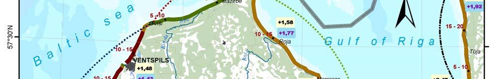
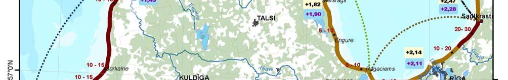
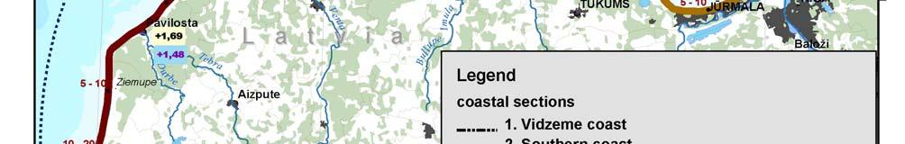
11 Results Assessment of the coastal processes that took place during the last 15 years was based on the long term coastal geological processes monitoring data and mapping of the coastal erosion cells after storms Results of these studies are presented in the maps: Coastal change and modern processes of the Gulf of Riga ( ) Coastal change and modern coastal processes of the open Baltic ( ) Coastal geology (types of the coast) High erosion risk coastal segments Coastal erosion in the storms of November 2001 Coastal erosion in the hurricane January 8/9, 2005 Coastal erosion in storm January 15, 2007 Latvian harbors activities and sediment loss Local factors determined coastal erosion


")


12 Coastal change and modern processes of the open Baltic ( )
13 Coastal geology

14 Coastal erosion

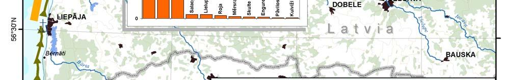

15 Latvian harbors activities and sediment loss


16 Local factors determined coastal erosion
17 Task 4: Field works Mapping of the coastal erosion after the winter spring storms 2006/2007 Mapping of the coastal protective structures of the Gulf of Riga Mapping the erosion risk the selected coastal sites (Roja, Saulkrasti)
18 Scientific and economic significance of results: Quantitative data on distribution of the coastal retreat and erosion rates were obtained fore the first time in Latvia The new data will be used to prepare a series of maps depicting Latvian coastline changes and coastal processes during the 20th century and, in particular, the recent 15 years ( ) In addition the maps will illustrate the coastal erosion that took place during separate strong storms (2001, 205, 2007) at different wind climate and storm surge levels in sites with varied coastal geology and expose These maps will describe the local factors determining the coastal erosion risk In 2008 these maps will be prepared and published as an atlas Coastline change and modern coastal processes in Latvia (27 maps) The results obtained in second phase of the work will serve as a basis for the phase 3 (2008), focusing on the coastal erosion forecast, flooding risks of low lying coastal areas, risk assessment fore the future years, under an impact of the climate change
19 WP 4 tasks fore the 3th phase (2008) Continuation of mapping of the coastal changes and measuring of coastal erosion after the winter storms of 2007/2008 Finalization of mapping and estimation of efficiency of coastal protective structures (open Baltic coast) and preparation of digital map Preparation of coastal erosion forecasts fore different climate change sceneries. Preparation of digital maps for coastal administrative units that could be used fore planning and management purposes Adaptation of EU erosion criteria fore conditions of Latvia, design of tailor made methodology fore risk assessment.

20
26 Coastal erosion and accretion
 26 Coastal erosion and accretion 26.1 Rate of erosion and accretion 26.2 Length of protected coastline 26.3 Volume of sand nourishment Fig. 26.1: Coastline dynamics of the South East Baltic region Key
E x a m p l e s o f t o o l s f o r s e a s i t u a t i o n a l a w a r e n e s s u s i n g C M E M S d a t a. Copernicus EU
 E x a m p l e s o f t o o l s f o r s e a s i t u a t i o n a l a w a r e n e s s u s i n g C M E M S d a t a Copernicus EU Copernicus EU Copernicus EU www.copernicus.eu S e a S i t u a t i o n a l A w
Coastal Erosion & Climate Change: PRIDE 2005 Towards an Alaska Wind/Wave Climatology
 Coastal Erosion & Climate Change: PRIDE 2005 Towards an Alaska Wind/Wave Climatology 2 nd PRIDE Workshop August 9-10, 2005 David Atkinson, Int l Arctic Research Center, Univ. Of Alaska-Fairbanks James
Hindcast Arabian Gulf
 Hindcast Arabian Gulf Image of isobars of atmospheric pressure and hindcast wind- and wave field over the Arabian Gulf during a storm in January 1993. Detailed wave studies are supported by nesting of
Climate Change and Mapping of the Future Nature
 Climate Change and Mapping of the Future Nature The XXIV FIG International Congress 2010 TS 4E Coasts and Natural Resources Tuesday 13 April Mr. Jesper Rye Rasmussen Denmark on the map Sydney, Australia,
Geography GCSE. Year 9 Term and Topic Unit Content Homework Opportunities
 Geography GCSE Year 9 Term and Topic Unit Content Homework Opportunities Autumn Term 1: Geographical Skills Autumn Term 2: Tectonic Hazards Spring Term 1: Ecosystems Rainforest Students are required to
Landscape Systems: Coasts 3 days
 AS Level Geography Edexcel Landscape Systems: Coasts 3 days Deliver two days of fieldwork within an inspiring physical environment covering all the recommended themes in depth. Prepare AS level students
Possibilities for applying ES assessment results in spatial planning in Latvia
 Possibilities for applying ES assessment results in spatial planning in Latvia Inga Hoņavko LIFE EcosystemServices project manager LIFE Viva Grass seminar, Sigulda, 17.05.2018 Projekts LIFE EcosystemServices,
Term Knowledge Using and applying Grade Criteria Autumn 1 Assessment window October Natural hazards pose major risks to people and property.
 Assessment Schedule Year 9 2015/6 Term Knowledge Using and applying Grade Criteria Autumn 1 Assessment window October 2015 3.1.1.2 Tectonic Natural hazards pose major risks to people and property. Definition
PHOTOGRAMMETRY AND GIS TECHNOL 1 OGIES FOR MONITORING COASTAL EROSION ALONG DAR ES SALAAM COASTLINE. By: Z.Y Masele, S.D Mayunga1.
 PHOTOGRAMMETRY AND GIS TECHNOL 1 OGIES FOR MONITORING COASTAL EROSION ALONG DAR ES SALAAM COASTLINE. By: Z.Y Masele, S.D Mayunga1 Abstract Dar Es salaam coastline is seriously suffering from coastal soil
Country Fiche Latvia Updated October 2016
 Country Fiche Latvia Updated October 2016 1. General information Marine area under Latvian jurisdiction includes inland sea waters, Territorial sea (12 nautical miles from the baseline) and exclusive economic
Quantifying effects of oil on coastal dune vegetation. Thomas Miller and Elise Gornish Biological Science, Florida State University
 Quantifying effects of oil on coastal dune vegetation Thomas Miller and Elise Gornish Biological Science, Florida State University Natural History of Barrier Islands in the Northern Gulf Make up ~70% of
Improving global coastal inundation forecasting WMO Panel, UR2014, London, 2 July 2014
 Improving global coastal inundation forecasting WMO Panel, UR2014, London, 2 July 2014 Cyclone Sidr, November 2007 Hurricane Katrina, 2005 Prof. Kevin Horsburgh Head of marine physics, UK National Oceanography
Coastal Systems and Landscapes 3 days
 AS Level Geography WJEC Coastal Systems and Landscapes 3 days This course is for Welsh schools. This in-depth course prepares students for the physical fieldwork focusing on the Coastal option, for Section
Coastal Resilience Project: towards the development of tools and solutions to adapt to coastal hazards for municipalities in Eastern Quebec
 Coastal Resilience Project: towards the development of tools and solutions to adapt to coastal hazards for municipalities in Eastern Quebec Great Lakes and St. Lawrence Cities Initiative 2018 Annual Meeting
Climate Change in Newfoundland & Labrador
 Climate Change in Newfoundland & Labrador Impacts and Adaptation Newleef Conference 08 October 2015 Met-Ocean Services The Team 55 personnel; 24/7 operational weather forecast desk; Equipment technician
Methods for assessing coastal vulnerability to climate change Dr. Silvia Torresan CMCC
 Methods for assessing coastal vulnerability to climate change Dr. Silvia Torresan CMCC Milan, 4 February 2016 Lecture OUTLINE: Overview of climate change impacts in coastal zones; Coastal Vulnerability
Issue to be addressed
 Climate change impacts in fluvial, coastal and transition zones in Mediterranean environments altered by human activities: Guadalfeo and Adra river mouths Andrea Lira Loarca - aliraloarca@ugr.es Manuel
GCSE 4242/02 GEOGRAPHY (Specification B) FOUNDATION TIER UNIT 2 SECTION B
 FOUNDATION TIER UNIT 2 SECTION B") Surname Centre Number Candidate Number Other Names 0 GCSE 4242/02 GEOGRAPHY (Specification B) FOUNDATION TIER UNIT 2 SECTION B S15-4242-02 P.M. WEDNESDAY, 3 June 2015 1 hour 30 minutes For s use Part Maximum
Surname Centre Number Candidate Number Other Names 0 GCSE 4242/02 GEOGRAPHY (Specification B) FOUNDATION TIER UNIT 2 SECTION B S15-4242-02 P.M. WEDNESDAY, 3 June 2015 1 hour 30 minutes For s use Part Maximum
since 1961 BALTICA Volume 30 Number 2 December 2017:
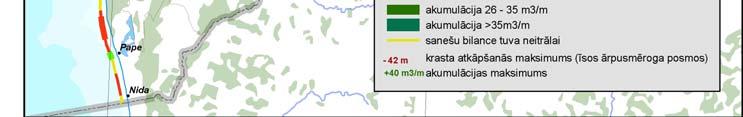
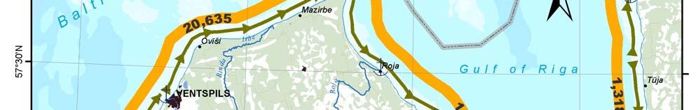
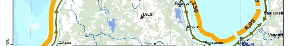
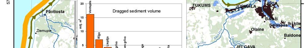
 since 1961 BALTICA Volume 30 Number 2 December 2017: 87 95 http://dx.doi.org/10.5200/baltica.2017.30.10 Coastal sediment balance in the eastern part of the Gulf of Riga (2005 2016) Jānis Lapinskis Lapinskis,
Brazil The country of Brazil is used to consider the different climatic conditions that can occur and why that is. Sport
 SUBJECT : Geography 2014 15 Yr7 What is geography? Students are introduced to the topic of geography and why it is so important to our everyday lives. Within the subject students explore the differences
A method for estimating coastline recession due to sea level rise by assuming stationary wind-wave climate
 Climate change - The environmental and socio-economic response in the southern Baltic region Szczecin, Poland, 12 15 2014 A method for estimating coastline recession due to sea level rise by assuming stationary
HELSINKI COMMISSION Baltic Marine Environment Protection Commission
 HELSINKI COMMISSION Baltic Marine Environment Protection Commission HELCOM RECOMMENDATION 24/10 Adopted 25 June 2003, having regard to Article 20, Paragraph 1 b) of the 1992 Helsinki Convention IMPLEMENTATION
The Use of Geographic Information Systems to Assess Change in Salt Marsh Ecosystems Under Rising Sea Level Scenarios.
 The Use of Geographic Information Systems to Assess Change in Salt Marsh Ecosystems Under Rising Sea Level Scenarios Robert Hancock The ecological challenges presented by global climate change are vast,
European Geosciences Union General Assembly Vienna, Austria 27 April - 02 May 2014
 European Geosciences Union General Assembly Vienna, Austria 27 April - 02 May 2014 Projecting the Current & Future Impact of Storm Surges on Coastal Flood Extent at Pigeon Point, South-West Tobago, through
Coastal Vulnerability and Risk Parameters
 European Water 11/12: 3-7, 2005. 2005 E.W. Publications Coastal Vulnerability and Risk Parameters E. Doukakis National Technical University of Athens-Dept. of Rural and Surveying Engineering, Lab. of Higher
Storm surge modeling at RSMC La Réunion. Cliquez pour modifier le style des sous-titres du masque
 Storm surge modeling at RSMC La Réunion Cliquez pour modifier le style du titre Cliquez pour modifier le style des sous-titres du masque 6th session training course of tropical cyclones (28 oct. 5 nov.
Remote sensing and GIS for multi-hazard risk assessments in the coastal zone: recent applications and challenges in the Pacific Jens Kruger
 Remote sensing and GIS for multi-hazard risk assessments in the coastal zone: recent applications and challenges in the Pacific Jens Kruger Geoscience Division Pacific Community (SPC) The First Pacific
The known requirements for Arctic climate services
 The known requirements for Arctic climate services based on findings described in STT White paper 8/2015 Johanna Ekman / EC PHORS STT Regional drivers The Arctic region is home to almost four million people
Natural Susceptibility to Coastal Erosion: Methodology and Mapping Summary
 Natural Susceptibility to Coastal Erosion: Methodology and Mapping Summary. Introduction The Flood Risk Management (Scotland) Act 2009 (FRM Act) introduced a coordinated and partnership approach to how
2013 ATLANTIC HURRICANE SEASON OUTLOOK. June RMS Cat Response
 2013 ATLANTIC HURRICANE SEASON OUTLOOK June 2013 - RMS Cat Response Season Outlook At the start of the 2013 Atlantic hurricane season, which officially runs from June 1 to November 30, seasonal forecasts
Meteorology in Latvia: History and future perspectives.
 Meteorology in Latvia: History and future perspectives. Dinara Gershinkova Latvian Hidrometeorological Agency, Riga, Latvia Dinara.Gershinkova@meteo.lv Last years we see very high interest to our service
OCEANOGRAPHY CURRICULUM. Unit 1: Introduction to Oceanography
 Chariho Regional School District - Science Curriculum September, 2016 OCEANOGRAPHY CURRICULUM Unit 1: Introduction to Oceanography OVERVIEW Summary In this unit students will be introduced to the field
Rising Sea Levels: Time for Proactive Action in Florida and the Caribbean?
 Rising Sea Levels: Time for Proactive Action in Florida and the Caribbean? Dr. Alan Fyall and Dr. Thomas Wahl National Center for Integrated Coastal Research, University of Central Florida Dr. Roberta
Effects of Sea Level Rise in Florida
 Abstract International Research Journal of Earth Sciences ISSN 2321 2527 Int. Res.J. Earth Sci. Effects of Sea Level Rise in Florida Praveen Khanna, Udaya Kumar and Riyaz Ahamed Osankhan Department of
Sea-level Rise on Cape Cod: How Vulnerable Are We? Rob Thieler U.S. Geological Survey Woods Hole, MA
 Sea-level Rise on Cape Cod: How Vulnerable Are We? Rob Thieler U.S. Geological Survey Woods Hole, MA Outline Sea-level and coastal processes Past sea-level change Predictions for the future Coastal responses
HydroSpatial II Practical application of INSPIRE in Marine Mapping Data
 HydroSpatial II Practical application of INSPIRE in Marine Mapping Data INSPIRE Conference 30 th June 2011 Carlos Berná Esteban, GIS Analyst, SeaZone carlos.berna-esteban@seazone.com Overview HydroSpatial
SEGMENTED BREAKWATERS AND THEIR USE IN COASTAL LOUISIANA
 SEGMENTED BREAKWATERS AND THEIR USE IN COASTAL LOUISIANA Prepared by: Louisiana Coastal Protection and Restoration Authority Engineering Division March 2016 The geology of Louisiana s coastal zone is intimately
How to Read These Flood Hazard Maps
 How to Read These Flood Hazard Maps The United States Geological Survey (USGS) has developed the Coastal Storms Modeling System (CoSMoS), which projects coastal flooding and erosion from coastal storms,
A methodology for impact, vulnerability and adaptation assessment in the coastal zone
 UNFCCC expert meeting on methods and tools and on data and observations under the Nairobi work programme on impacts, vulnerability and adaptation to climate change Mexico City, Mexico, 4-7 March 2008 A
Eco-hydromorphic Characterization of the Louisiana Coastal Region Using Multiple Remotely Sensed Data Sources and Analyses
 National Wetlands Research Center Eco-hydromorphic Characterization of the Louisiana Coastal Region Using Multiple Remotely Sensed Data Sources and Analyses 1Holly Beck, 2 Brady Couvillion, 1 Nadine Trahan
Temporal and spatial scales of the features and processes forming the Polish Baltic Sea coast
 The coasts of the North Sea and the Baltic Sea under climate change - synthesis of German and Polish strategies for development and prediction, Hamburg, 11 12 October, 2016, German Polish Seminar Temporal
SUBJECT : Geography Topics: Learning Outcomes:
 SUBJECT : Geography 2016-17 Yr7 What is geography and Britain? Students are introduced to the topic of geography and why it is so important to our everyday lives. Within the subject students explore the
Protection of Coasts
 Protection of Coasts [Coastal Zones] Jan van de Graaff Delft University of Technology 1 Coastal Zone: many definitions here: rather narrow strip of land adjacent to sea or large inland water (say: 150
Storm surges in the easternmost Gulf of Finland during operation of the Flood Protection Barrier of St. Petersburg
 Storm surges in the easternmost Gulf of Finland during operation of the Flood Protection Barrier of St. Petersburg V.Ryabchenko 1, P.Andreev 2, A.Averkiev 3, A.Dvornikov 1, K.Klevanny 4, V.Tsepelev 2 1
Climate Change Impacts and Adaptation for Coastal Transport Infrastructure in Caribbean SIDS
 UNCTAD National Workshop Saint Lucia 24 26 May 2017, Rodney Bay, Saint Lucia Climate Change Impacts and Adaptation for Coastal Transport Infrastructure in Caribbean SIDS LISCoAsT Large Scale Integrated
Storm-surges Indicator for the Polish Baltic Coast
 International Journal on Marine Navigation and Safety of Sea Transportation Volume Number March Storm-surges Indicator for the Polish Baltic Coast I. Stanislawczyk Institute of Meteorology and Water Management,
GLY Coastal Geomorphology Notes
 GLY 4734 - Coastal Geomorphology Notes Dr. Peter N. Adams Spring 2011 2 Coastal Classification In this lecture, we discuss some successful classification schemes of the coastal landscape, and pay particular
Marine Spatial Planning: A Tool for Implementing Ecosystem-Based Management
 Marine Spatial Planning: A Tool for Implementing Ecosystem-Based Management Steven Murawski, Ph.D., Ecosystem Goal Team Lead National Oceanic and Atmospheric Administration NOAA November 16, 2009 1 To
Climate change and it s impacts in Latvia. Faculty of Geography and Earth Sciences, University of Latvia
 Climate change and it s impacts in Latvia Agrita Briede,, Jānis Lapinskis and Māris Kļaviņš Faculty of Geography and Earth Sciences, University of Latvia Parameters used to ilustrate climate variability
Australian Coastal Councils Conference
 Australian Coastal Councils Conference 11 March 2015 Estimating Future Coastal Inundation and Erosion Hazards Dr Andrew McCowan Dr Christine Lauchlan-Arrowsmith Warwick Bishop Background Victorian Future
Term: Autumn Spring Summer
 What is geography and map skills? 1. What is Geography? 2. Physical Geography of the UK 3. Human Geography of the UK 4. Global Map 5. Map symbols 6. Mental mapping 7.6 Figure grid references 8. Making
AS & A2 Geography for OCR. Tailored Courses. Slapton Ley
 AS & A2 Geography for OCR Tailored Courses Slapton Ley Please visit http://www.field-studies-council.org/outdoorclassroom/geography/aqa/ for alternative A-level AQA programmes OVERVIEW Since the assessment
Advancing Geoscientific Capability. Geological Survey of Finland
 Advancing Geoscientific Capability Geological Survey of Finland GTK in brief The Geological Survey of Finland (GTK) is one of the largest European centres of excellence in assessment, research and the
Sri Lanka has a coastline of km excluding the shoreline of bays and inlets.
 Defining and Demarcating Coastal zones in Sri Lanka Procedure, Challenges and What needs to be done? Dr. Anil Premaratne Director General Coast Conservation Coast Conservation Department Sri Lanka 1 Sri
Unit 1 Living with the Physical Environment
 Unit 1 Living with the Physical Environment Topic Example / Case Study Example Tectonic Hazards Chile Nepal Weather Hazards Typhoon Haiyan Somerset Floods Climate Change Ecosystems Tropical Rainforests
Coastal Impacts of Climate Change in the Northwest: A Summary of the Findings of the upcoming National Climate Assessment
 Western Washington University Western CEDAR Salish Sea Ecosystem Conference 2014 Salish Sea Ecosystem Conference (Seattle, Wash.) May 1st, 3:30 PM - 5:00 PM Coastal Impacts of Climate Change in the Northwest:
Ice Sheets and Sea Level -- Concerns at the Coast (Teachers Guide)
") Ice Sheets and Sea Level -- Concerns at the Coast (Teachers Guide) Roughly 153 million Americans (~53% of the US population) live in coastal counties. World wide some 3 billion people live within 200 km
Ice Sheets and Sea Level -- Concerns at the Coast (Teachers Guide) Roughly 153 million Americans (~53% of the US population) live in coastal counties. World wide some 3 billion people live within 200 km
Forecast of Nearshore Wave Parameters Using MIKE-21 Spectral Wave Model
 Forecast of Nearshore Wave Parameters Using MIKE-21 Spectral Wave Model Felix Jose 1 and Gregory W. Stone 2 1 Coastal Studies Institute, Louisiana State University, Baton Rouge, LA 70803 2 Coastal Studies
Aquaculture Spatial Planning: The case of Greece
 Aquaculture Spatial Planning: The case of Greece Nikos Anagnopoulos Panhellenic Association for Small-Medium sized Aquaculture Enterprises Panhellenic Association for Small-Medium sized Aquaculture Enterprises
Geography for Life. Course Overview
 Geography for Life Description In Geography for Life students will explore the world around them. Using the six essential elements established by the National Geographic Society students will be able to
Country Fiche Latvia.
 Country Fiche Latvia 1. General information Marine waters under Latvian jurisdiction include inland sea waters, territorial sea (12 nautical miles from the baseline) and exclusive economic zone (EEZ) waters.
C o p e r n i c u s E m e r g e n c y M a n a g e m e n t S e r v i c e f o r e c a s t i n g f l o o d s
 C o p e r n i c u s E m e r g e n c y M a n a g e m e n t S e r v i c e f o r e c a s t i n g f l o o d s Copernicus & Copernicus Services Copernicus EU Copernicus EU Copernicus EU www.copernicus.eu W
Coastal Mapping Follow on? Bruno Frachon Corine Lochet Gaël Morvan
 Coastal Mapping Follow on? Bruno Frachon Corine Lochet Gaël Morvan Shared objectives; IHO DG MARE CPMR Development of a Joint European Coastal Mapping Programme (JECMaP) within the IHO EU network with
Regional-scale understanding of the geologic character and sand resources of the Atlantic inner continental shelf, Maine to Virginia
 Regional-scale understanding of the geologic character and sand resources of the Atlantic inner continental shelf, Maine to Virginia Workshop on Dredging, Beach Nourishment and Bird Conservation Atlantic
Graduate Courses Meteorology / Atmospheric Science UNC Charlotte
 Graduate Courses Meteorology / Atmospheric Science UNC Charlotte In order to inform prospective M.S. Earth Science students as to what graduate-level courses are offered across the broad disciplines of
I CAN DO sheets Southchurch High School
 Rate your confidence in the following topic content and geographical skills by ticking the appropriate column beside each point: Red = Not confident Yellow = Almost there Green = Confident Changing landscapes
Coastal Systems and Landscapes 3 days
 AS Level Geography Eduqas Coastal Systems and Landscapes 3 days Deliver two days of fieldwork within an inspiring physical environment. Prepare AS level students for Paper 1 Section B: Fieldwork Investigation
Time allowed: 1 hour 30 minutes
 SPECIMEN ASSESSMENT MATERIAL GCSE GEOGRAPHY Paper 1 Living with the physical environment Specimen Materials For this paper you must have: a pencil a ruler. Time allowed: 1 hour 30 minutes Instructions
The MSC Beaufort Wind and Wave Reanalysis
 The MSC Beaufort Wind and Wave Reanalysis Val Swail Environment Canada Vincent Cardone, Brian Callahan, Mike Ferguson, Dan Gummer and Andrew Cox Oceanweather Inc. Cos Cob, CT, USA Introduction: History
Numerical models in context of coastal climate change, adaptation and protection schemes. Nils Drønen Head of Innovation, CED, DHI
 Numerical models in context of coastal climate change, adaptation and protection schemes Nils Drønen Head of Innovation, CED, DHI Agenda Introduction How can we quantify coastal response to climate change
Hurricane Harvey: Texas Coastal Erosion Hot Spot Analysis
 Hurricane Harvey: Texas Coastal Erosion Hot Spot Analysis Texas ASBPA Symposium April 24, 2018 Alan Johnson, FEMA Chris Levitz, Compass Agenda Introduction Hurricane Harvey Erosion Hot Spot Analysis Purpose
PROJECT DESCRIPTION. 1. Introduction Problem Statement
 Salmun, H: A proposal submitted to PSC-CUNY program on October 15, 2009. Statistical prediction of storm surge associated with East Coast Cool-weather Storms at The Battery, New York. Principal Investigator:
Building Marina Resilience to Storms Wisconsin Marine Association Conference November 2-3, 2016
 Julia Noordyk NOAA Great Lakes Coastal Storms Program Outreach Coordinator UW Sea Grant @NoordCoast Building Marina Resilience to Storms Wisconsin Marine Association Conference November 2-3, 2016 July
Protecting the Storm Damage Prevention and Flood Control Interests of Coastal Resource Areas
 Protecting the Storm Damage Prevention and Flood Control Interests of Coastal Resource Areas Presented by: Massachusetts Department of Environmental Protection & Massachusetts Office of Coastal Zone Management
Climate change, vulnerability and the coasts. Sifting the evidence sea level rise
 CSE s Regional Media Briefing Workshop on Coasts, Coastal Populations and their Concerns Goa, August 13-14, 2010 Climate change, vulnerability and the coasts Sifting the evidence sea level rise Satheesh
Sediment Transport and Strata Formation in the Adriatic Sea
 Sediment Transport and Strata Formation in the Adriatic Sea Wayne R. Geyer James D. Irish Peter A. Traykovski Woods Hole Oceanographic Institution Woods Hole, MA 02543 Tel. (508) 289-2868, Fax: (508) 457-2194,
USING MIKE TO MODEL COASTAL CATASTROPHE RISK
 USING MIKE TO MODEL COASTAL CATASTROPHE RISK Nicola Howe, Christopher Thomas, Joss Matthewman, John Maskell* 1 SUMMARY About RMS Who are we and what do we do? How do we use MIKE in our workflow? Case study:
Storm Surge/Coastal Inundation State of the Union. Jamie Rhome Storm Surge Team Lead NOAA/National Hurricane Center
 Storm Surge/Coastal Inundation State of the Union Jamie Rhome Storm Surge Team Lead NOAA/National Hurricane Center 2 Tampa: Cat 5 Scenario 3 4 The Stakes are High Combination of SLR and increasing coastal
HUMAN INTERVENTIONS AND ALTERATIONS OF THE GEOMORPHOLOGICAL CHARACTERISTICS IN PARTS OF THE COASTAL AREA IN THE IONIAN COAST (IPIROS - GREECE)
") HUMAN INTERVENTIONS AND ALTERATIONS OF THE GEOMORPHOLOGICAL CHARACTERISTICS IN PARTS OF THE COASTAL AREA IN THE IONIAN COAST (IPIROS - GREECE) Α. Mertzanis (1), F. Marabini (2), A. Galvani (3), S. Castelli
HUMAN INTERVENTIONS AND ALTERATIONS OF THE GEOMORPHOLOGICAL CHARACTERISTICS IN PARTS OF THE COASTAL AREA IN THE IONIAN COAST (IPIROS - GREECE) Α. Mertzanis (1), F. Marabini (2), A. Galvani (3), S. Castelli
WP5 Task 5.4 Coastal municipal governance: Salacgrīva municipality (Latvia)
") 12 15 April 2015, project kick-off meeting Leibniz-Institute for Baltic Sea Research (IOW) Warnemünde, Germany WP5 Task 5.4 Coastal municipal governance: Salacgrīva municipality (Latvia) Coastal municipal
12 15 April 2015, project kick-off meeting Leibniz-Institute for Baltic Sea Research (IOW) Warnemünde, Germany WP5 Task 5.4 Coastal municipal governance: Salacgrīva municipality (Latvia) Coastal municipal
The "Geo-Information System Coast Mecklenburg-Vorpommern"
 The "Geo-Information System Coast Mecklenburg-Vorpommern" Lars Tiepolt State Office for Environment and Nature Rostock, Germany Abstract The Division Coast of the State Office for Environment and Nature
Belfast Sea Level Rise A Briefing for Policy Makers
 Belfast Sea Level Rise A Briefing for Policy Makers Version 3, issued 16/02/17 This paper briefly sets out the relative current rate of sea level rise in Belfast, and how this increases the risk of coastal
LIDAR AND BATHYMETRIC REMOTE SENSING APPLICATIONS IN MAPPING COASTAL EROSION YAQUINA HEAD, OREGON
 LIDAR AND BATHYMETRIC REMOTE SENSING APPLICATIONS IN MAPPING COASTAL EROSION YAQUINA HEAD, OREGON By Brooks Adam Hadsall Geography 493/593 Digital Terrain Analysis Photo: Friends of Yaquina Head Lighthouse,
GMES Service for Geospatial Reference Data Access (RDA) Covering Areas Outside Europe
 Covering Areas Outside Europe") INSPIRE Conference 2011 Edinburgh 27 June - 1 July GMES Service for Geospatial Reference Data Access (RDA) Covering Areas Outside Europe Andrea Ajmar, Simone Balbo, Piero Boccardo, Simone Dalmasso, Anna
INSPIRE Conference 2011 Edinburgh 27 June - 1 July GMES Service for Geospatial Reference Data Access (RDA) Covering Areas Outside Europe Andrea Ajmar, Simone Balbo, Piero Boccardo, Simone Dalmasso, Anna
PRMS WHITE PAPER 2014 NORTH ATLANTIC HURRICANE SEASON OUTLOOK. June RMS Event Response
 PRMS WHITE PAPER 2014 NORTH ATLANTIC HURRICANE SEASON OUTLOOK June 2014 - RMS Event Response 2014 SEASON OUTLOOK The 2013 North Atlantic hurricane season saw the fewest hurricanes in the Atlantic Basin
Geol 117 Lecture 18 Beaches & Coastlines. I. Types of Coastlines A. Definition:
 I. Types of Coastlines A. Definition: 1. Shore = narrow zone where ocean meets land (e.g. beach) 2. Coast is a broad area where both ocean and land processes act a. Includes onshore marshes, dunes, sea
Latest trends in sea level rise and storm surges in Maine Peter A. Slovinsky, Marine Geologist
 Latest trends in sea level rise and storm surges in Maine Peter A. Slovinsky, Marine Geologist Image from Chebeague.org Maine s glacial geology and historic sea level rise trends Current sea level trends
Monitoring the coastal ocean: from local to regional
 Monitoring the coastal ocean: from local to regional Luísa Bastos University of Porto / CIIMAR RAIA partners Ocean monitoring To answer key societal and scientific challenges navigation safety, fisheries,
Landslide Hazard Assessment Methodologies in Romania
 A Scientific Network for Earthquake, Landslide and Flood Hazard Prevention SciNet NatHazPrev Landslide Hazard Assessment Methodologies in Romania In the literature the terms of susceptibility and landslide
Process-based Long Term Morphological Modelling the present state-of-the-art and the way ahead. Dirk-Jan Walstra
 Process-based Long Term Morphological Modelling the present state-of-the-art and the way ahead Dirk-Jan Walstra Deltares Delft Hydraulics Delft University of Technology Les littoraux à l heure du changement
Joanne N. Halls, PhD Dept. of Geography & Geology David Kirk Information Technology Services
 Joanne N. Halls, PhD Dept. of Geography & Geology David Kirk Information Technology Services Geographic Information Systems manage and analyze data to solve spatial problems. Real World Abstraction Analysis
FIG Working Week May, Bulgaria From the wisdom of the ages to the challanges of modern world
 FIG Working Week 17-21 May, Bulgaria From the wisdom of the ages to the challanges of modern world COASTAL RISK ANALYSIS OF THE BLACK SEA UNDER THE SEA LEVEL RISE N e v i n B e t u l A V S A R, S e n o
1. Demand for property on the coast
 1. Demand for property on the coast Key message Irrespective of density and location, population in Europe in general tends to concentrate in coastal areas. Detailed spatial elaboration of processes shows
Mapping of marine habitats in shallow coastal areas in Denmark
 6 th Workshop Seabed Acoustics, Rostock, November 14/15, 2013 P11-1 Mapping of marine habitats in shallow coastal areas in Denmark Dr. Zyad Al-Hamdani Geological Survey of Denmark and Greenland - GEUS
Changes in Frequency of Extreme Wind Events in the Arctic
 Changes in Frequency of Extreme Wind Events in the Arctic John E. Walsh Department of Atmospheric Sciences University of Illinois 105 S. Gregory Avenue Urbana, IL 61801 phone: (217) 333-7521 fax: (217)
Mapping Coastal Change Using LiDAR and Multispectral Imagery
 Mapping Coastal Change Using LiDAR and Multispectral Imagery Contributor: Patrick Collins, Technical Solutions Engineer Presented by TABLE OF CONTENTS Introduction... 1 Coastal Change... 1 Mapping Coastal
Coastal Barrier Island Network (CBIN): Management strategies for the future
: Management strategies for the future") Coastal Barrier Island Network (CBIN): Management strategies for the future Heather Joesting*, Amy Williams**, Rusty Feagin**, and William K. Smith* *Department of Biology, Wake Forest University, Winston
Coastal Barrier Island Network (CBIN): Management strategies for the future Heather Joesting*, Amy Williams**, Rusty Feagin**, and William K. Smith* *Department of Biology, Wake Forest University, Winston
Coastal Litigation in the Context of Science Literacy
 Coastal Litigation in the Context of Science Literacy Chris McLindon New Orleans Geological Society February 6, 7 Science Literacy The value of community participation in scientific research is widely
2.- Area of built-up land
 2.- Area of built-up land Key message Over recent decades, built-up areas have been steadily increasing all over Europe. In Western European countries, built-up areas have been increasing faster than the