Coastal Litigation in the Context of Science Literacy
|
|
|
- Rose Nicholson
- 5 years ago
- Views:
Transcription


1 Coastal Litigation in the Context of Science Literacy Chris McLindon New Orleans Geological Society February 6, 7 Science Literacy The value of community participation in scientific research is widely recognized and supported by evidence. Community involvement can bring new questions to light, provide data that would otherwise be unavailable, encourage the integration of qualitative and observational data with experimental data, increase the robustness and public relevance of data collection strategies, garner political and community support for conclusions, produce new instruments and technologies, and build community awareness and knowledge.
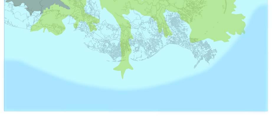
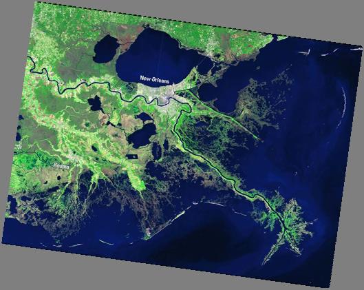
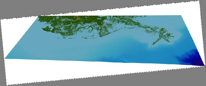
2 Challenges to Science Literacy The wetlands of south Louisiana were built up in a continuous and progressive increase in land area by the deposition of sediment by the Mississippi River over the last 6, years. Until the middle part of the th century these wetlands provided a protective buffer to most residents of coastal Louisiana from storm surge generated by hurricanes. Thelossofhundredsofthousandsofacresofwetlandsoverthepastfew decades is an unprecedented even in the history of the coast. Wetlands loss has primarily been caused by coastal erosion caused by saltwater intrusion carried into the wetlands by oil and gas canals. Because wetlands loss was primarily caused by the action of humans, it can also be reversed by the actions of humans. Challenges to Science Literacy Board of Commissioners of the Southeast Louisiana Flood Protection Authority E, et al. v. Tennessee Gas Pipeline Company, LLC, et al., No. 69, Civil District Court for the Parish of Orleans, Louisiana Coastal lands have for centuries provided a crucial buffer zone between south Louisiana's communities and the violent wave action and storm surge that tropical storms and hurricanes transmit from the Gulf of Mexico. Coastal lands are a natural protective buffer, without which the levees that protect the cities and towns of south Louisiana are left exposed to unabated destructive forces. This natural protective buffer took 6, years to form. Yet, as described below, it has been brought to the brink of destruction over the course of a single human lifetime. Hundreds of thousands of acres of the coastal lands that once protected south Louisiana are now gone as a result of oil and gas industry activities
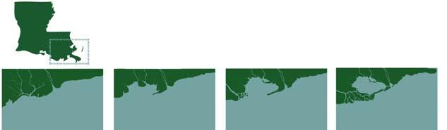
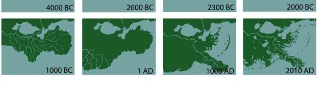


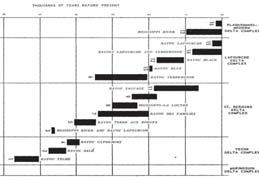
3 Challenges to Science Literacy The Coastal Litigation Model Science Literacy Thousand Years Before Present 6 The Frazier Model


4 The Frazier Model, years before present, years before present Pine Islands Stonehenge Pyramids of Giza, years before present, years before present Linear B Writing Greek Culture The Frazier Model, years before present years before present Roman Empire Desoto Finds the Mississippi 9 6


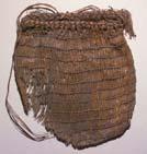
5 The Delta Cycle St. Bernard Delta Bayou Jasmine Archeological Site Twinned bag ca. 8 BC, years before present

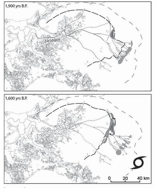


6 Historical Land Loss Subsided in, years = mm/yr Rogers, B.E. et.al., 9 The Delta Cycle 6


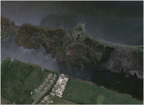
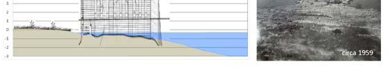
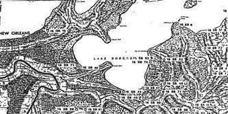
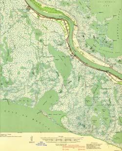
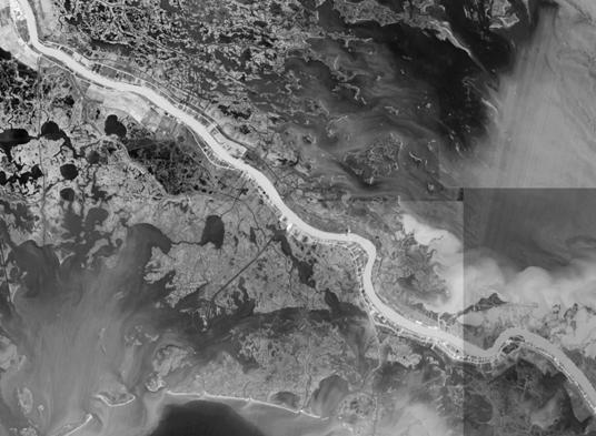
7 Old Paris Road Fort Proctor & Shell Beach CORS Fort CORS Shell Beach 7


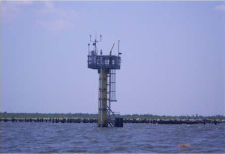
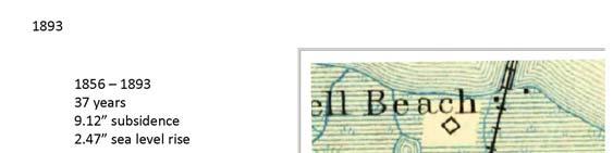
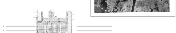
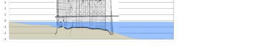
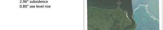
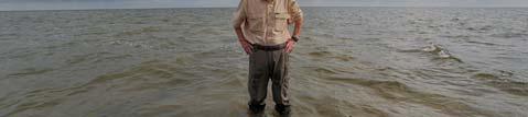
8 Fort Proctor & Shell Beach CORS Fort Proctor Elevation of the Fort is 9. inches higher than today Elevation of Sea Level is.7 inches lower than today 8


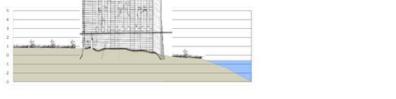

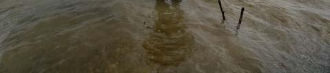
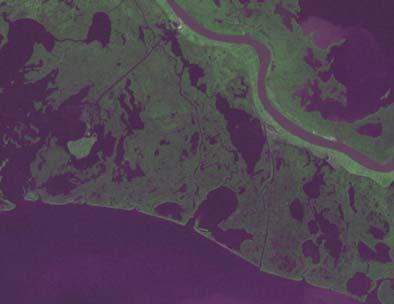
9 Fort Proctor Fort Proctor 9


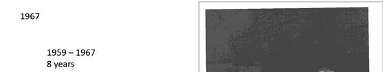
10 Fort Proctor Fort Proctor


11 Fort Proctor Fort Proctor


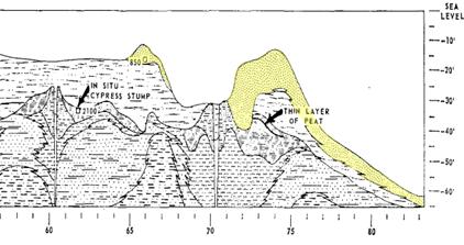
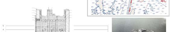
12 Fort Proctor Plaquemines Period years ago Fort Proctor 86 Islenos Settlement 78 s


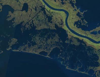
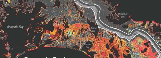
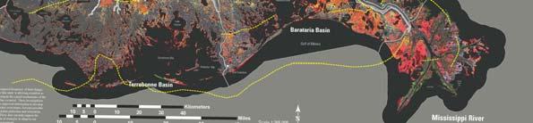
13 The Delta Cycle Barataria Bay


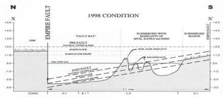
14 Barataria Bay A Empire Fault A Empire Fault Empire Fault


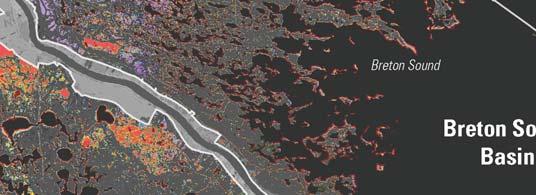
15 9 Empire Fault Bastian Bay Fault 97


16


17


18 8


19 from 9 to inches/yr. 7 mm/yr 9


20 Lake Hermitage Surface Fault Trace


21 Lake Hermitage Surface Fault Trace Lake Hermitage Lake Hermitage Marsh Creation Projectt Surface Fault Trace Geotechnical analysis grossly underestimated the response to emplaced fill Rudy Simoneux, CPRA Engineer, 6 State of the Coast Conference


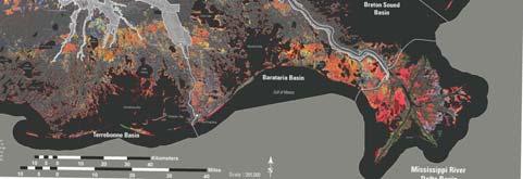

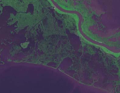
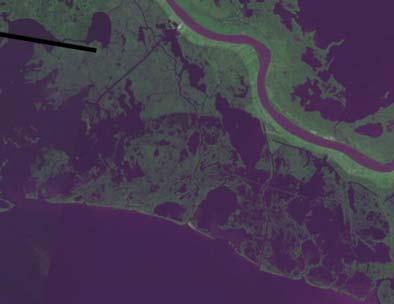
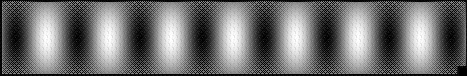
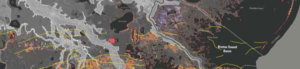
22 Hot Spots of Land Loss Hot Spots of Land Loss Land Loss in Southeast Louisiana


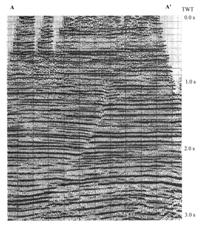
23 Subsurface Geology Empire Fault West Delta Fault The Geological Model


24 NOGS Research Effort NOGS Research Effort Geophysical Pursuit Lake Pontchartrain -D UNO Schlumberger Lake Borgne -D UNO Schlumberger Grand Lake Merge -D UT Austin Seitel Lapeyrouse -D Tulane Castex Energy Bully Camp -D ULL Schlumberger Lake Hermitage -D UNO Chevron Terrebonne Bay -D LSU
A Proposal to Create an Atlas of Surface Fault Traces in South Louisiana
 A Proposal to Create an Atlas of Surface Fault Traces in South Louisiana Executive Summary The common conception of land loss in the south Louisiana wetlands is that is has been caused by the dredging
Wetland attenuation of Hurricane Rita s storm surge
 Wetland attenuation of Hurricane Rita s storm surge Pat Fitzpatrick, Yee Lau, Yongzuo Li, Nam Tran, Chris Hill, and Suzanne Shean Geosystems Research Institute, Mississippi State University Sponsors: NOAA
Coastal Litigation in the Context of Science Literacy
 Coastal Litigation in the Context of Science Literacy Chris McLindon New Orleans Geological Society The various lawsuits filed by levee boards and parish governments in the coastal zone of south Louisiana
Unchain the River and Allow it to Build a Delta
 Unchain the River and Allow it to Build a Delta Harley S. Winer Atkins Harley.Winer@atkinsglobal.com Mississippi River Drainage Basin Basin Facts Drains 41% of continental U.S. Includes 31 states & 2 Canadian
Subsidence in Terrebonne Parish May be Slowing Down
 Subsidence in Terrebonne Parish May be Slowing Down James M. Sothern, MS Adjunct Instructor of Geology Fletcher Technical Community College Houma, LA Introduction Natural subsidence across the gulf coast
Chris McLindon Coastal Restoration in light of the geology of New Orleans and surrounding area.
 New Orleans Chapter Newsletter Society of Independent Professional Earth Scientists Volume 15, Number 15 May 2014 Chairman s Column At last month s meeting, speaker Kirk Barrell delivered a real seminar
Report on the Damage Survey Caused by Hurricane Katrina (Tentative Report)
") Report on the Damage Survey Caused by Hurricane Katrina (Tentative Report) November 1, 2005 Coastal Disaster Prevention Technology Survey Team 1. Introduction Hurricane Katrina struck the United States
Report on the Damage Survey Caused by Hurricane Katrina (Tentative Report) November 1, 2005 Coastal Disaster Prevention Technology Survey Team 1. Introduction Hurricane Katrina struck the United States
Hurricane Tracks. Isaac versus previous storms Impacts and solutions. ( Continue by clicking on the slide bar to the right)
") Hurricane Tracks Isaac versus previous storms Impacts and solutions ( Continue by clicking on the slide bar to the right) 1 Hurricane Tracks 2 Sample Hurricanes The sample hurricanes selected were chosen
Hurricane Tracks Isaac versus previous storms Impacts and solutions ( Continue by clicking on the slide bar to the right) 1 Hurricane Tracks 2 Sample Hurricanes The sample hurricanes selected were chosen
MISSISSIPPI RIVER DELTA OVERVIEW
 MISSISSIPPI RIVER DELTA OVERVIEW Science and Engineering Special Team Conference Louisiana State University October 9, 2012 Introduction Basics of the Mississippi Delta Natural and Human-Induced Land Loss
Application #: TEXT
 TOWN OF FORT MYERS BEACH 2008 PROPOSED COMPREHENSIVE PLAN AMENDMENTS Application #: 2008-13-TEXT Description: Modify the Coastal Management and Future Land Use Elements to reflect the state s new definition
Hurricane Katrina and Oil Spills: Impact on Coastal and Ocean Environments
 Archived version from NCDOCKS Institutional Repository http://libres.uncg.edu/ir/asu/ Pine, J. C. (June 2006). Hurricane Katrina and oil spills: Impact on coastal and ocean environments. Oceanography,
Lab 12 Coastal Geology
 Lab 12 Coastal Geology I. Fluvial Systems Hydrologic Cycle Runoff that flows into rivers = precipitation (rain and snowmelt) [infiltration (loss to groundwater) + evaporation (loss to atmosphere) + transpiration
An analysis of storm surge attenuation by wetlands using USGS, FEMA, and NASA data
 An analysis of storm surge attenuation by wetlands using USGS, FEMA, and NASA data Pat Fitzpatrick Geosystems Research Institute Mississippi State University Walter Peterson and Courtney Buckley NASA Marshall
Name: Date: Class: Louisiana: Our History, Our Home Chapter 1: Louisiana s Geography - Section 2: Natural Regions Guided Reading
 Instructions: Read the section and complete each item with words from the passages in this section. 1. The diversity of Louisiana s can surprise residents and visitors alike. 2. Physical geography is concerned
HURRICANE NATE BRIEFING
 HURRICANE NATE BRIEFING 2:00 PM CDT Saturday, October 07, 2017 Prepared by: NWS NWSNewOrleans www.weather.gov/neworleans Situation Overview continues to intensify. It is now forecast to be a category 2
PART 4 GEOLOGIC SETTING AND FOUNDATION CONDITIONS IN NEW ORLEANS
 PART 4 GEOLOGIC SETTING AND FOUNDATION CONDITIONS IN NEW ORLEANS The modern Mississippi Delta has been deposited during the past 6000 years, in four major areas. Current interpretation of the modern delta.
Hurricane Katrina. Learning Objective: -Analyse the causes, effects and responses of a tropical storm
 Hurricane Katrina Learning Objective: -Analyse the causes, effects and responses of a tropical storm Learning Outcomes: -Classify the impacts of Hurricane Katrina -Apply understanding to an exam question
Earth Wind & Fire. Game Changing Restoration Options in the Texas Chenier Plain
 Earth Wind & Fire Game Changing Restoration Options in the Texas Chenier Plain EARTH: The Chenier Plain is a 5 million acre coastal region in Southwest Louisiana and Southeast Texas providing landscape
Appendix A STORM SURGE AND WAVE HEIGHT ANALYSIS
 Appendix A STORM SURGE AND WAVE HEIGHT ANALYSIS Memo To: Jeff Robinson, P.E., GEC, Inc. From: Silong Lu, Ph.D., P.E., D.WRE, Dynamic Solutions, LLC. Date: 1/9/2014 CC: Re: Chris Wallen, Vice President,
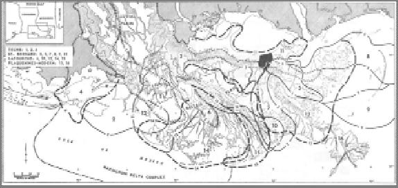
CHAPTER FIVE: THE LOWER MISSISSIPPI REGION AND PLAQUEMINES PARISH
 CHAPTER FIVE: THE LOWER MISSISSIPPI REGION AND PLAQUEMINES PARISH 5.1 Overview Plaquemines Parish is the area where the last portion of the Mississippi River flows out into the Gulf of Mexico (see Figures
PART 5 MECHANISMS OF GROUND SETTLEMENT IN GREATER NEW ORLEANS
 PART 5 MECHANISMS OF GROUND SETTLEMENT IN GREATER NEW ORLEANS Predicted water depth in New Orleans flood inundation area based on water level of 2.37 ft in Lake Ponchartrain on Sept 2, 2005. Overlay on
Environmental Documents Prepared for Proposed Oil, Gas, and Mineral Operations by the Gulf of Mexico Outer Continental Shelf (OCS) Region
 Region") This document is scheduled to be published in the Federal Register on 03/27/2012 and available online at http://federalregister.gov/a/2012-07364, and on FDsys.gov Billing Code: 4310-MR DEPARTMENT OF THE
This document is scheduled to be published in the Federal Register on 03/27/2012 and available online at http://federalregister.gov/a/2012-07364, and on FDsys.gov Billing Code: 4310-MR DEPARTMENT OF THE
Subsidence in Terrebonne Parish may be Slowing Down
 Subsidence in Terrebonne Parish may be Slowing Down James M. Sothern, MS, Adjunct Instructor of Geology, Fletcher Technical Community College, 31 St. Charles St. Houma, LA 736-2863; jamessothern@charter.net
The Coast: Beaches and Shoreline Processes
 1 2 3 4 5 6 7 8 9 The Coast: es and Shoreline Processes Trujillo & Thurman, Chapter 10 Oceanography 101 Chapter Objectives Recognize the various landforms characteristic of beaches and coastal regions.
The Coast: Beaches and Shoreline Processes Trujillo & Thurman, Chapter 10
 The Coast: es and Shoreline Processes Trujillo & Thurman, Chapter 10 Oceanography 101 Chapter Objectives Recognize the various landforms characteristic of beaches and coastal regions. Identify seasonal
The Mississippi River: Its Role in Restoration Efforts and Potential Effects of Climate Change
 The Mississippi River: Its Role in Restoration Efforts and Potential Effects of Climate Change Clinton S. Willson, P.E., Ph.D. Department of Civil & Environmental Engineering Louisiana State University
Reducing Nitrogen Removal Uncertainty for Operation of Mississippi River Sediment Diversions: Nitrate Reduction Rates In Turbulent Flow Conditions
 Reducing Nitrogen Removal Uncertainty for Operation of Mississippi River Sediment Diversions: Nitrate Reduction Rates In Turbulent Flow Conditions Nia R. Hurst, John R. White, Kehui Xu, and MingCheng Ren
Programmatic Approaches to Assessing and Mitigating Risk to Pipelines from Natural Forces
 Programmatic Approaches to Assessing and Mitigating Risk to Pipelines from Natural Forces 23 rd International Petroleum Environmental Conference New Orleans, Louisiana November 8-10, 2016 Introduction
SEA LEVEL RISE IN THE 2017 COASTAL MASTER PLAN
 SEA LEVEL RISE IN THE 2017 COASTAL MASTER PLAN James W. Pahl, Ph.D. Coastal Resources Scientist, Senior Presentation to the Barataria-Terrebonne National Estuary Program Management Conference Meeting Nicholls
SEGMENTED BREAKWATERS AND THEIR USE IN COASTAL LOUISIANA
 SEGMENTED BREAKWATERS AND THEIR USE IN COASTAL LOUISIANA Prepared by: Louisiana Coastal Protection and Restoration Authority Engineering Division March 2016 The geology of Louisiana s coastal zone is intimately
Tropical Weather Briefing
 Tropical Weather Briefing August 28, 2012 700 AM CDT National Weather Service Weather Forecast Office Slidell, LA Current Satellite Tropical Storm Isaac Watches/Warnings Tropical Storm Isaac Track Guidance
Smooth Cordgrass Varieties. Description and Performance
 Smooth Cordgrass Varieties Description and Performance Smooth cordgrass (Spartina alterniflora Loisel.) is a perennial grass native to intertidal saline marshes along the Gulf of Mexico and Atlantic coasts.
THE IMPORTANCE OF SCIENCE IN COASTAL RESTORATION IN LOUISIANA
 THE IMPORTANCE OF SCIENCE IN COASTAL RESTORATION IN LOUISIANA Barb Kleiss USACE, Mississippi Valley Division August 3, 2011 LCA S&T Office Authorized under WRDA 2007 Designed to address technical issues
2 Georgia: Its Heritage and Its Promise
 TERMS region, erosion, fault, elevation, Fall Line, aquifer, marsh, climate, weather, precipitation, drought, tornado, hurricane, wetland, estuary, barrier island, swamp PLACES Appalachian Mountains, Appalachian
Changes in Ecosystems - Natural Events
 Changes in Ecosystems - Natural Events 8A predict and describe how different types of catastrophic events impact ecosystems such as floods, hurricanes, or tornadoes Textbook pages: 396-406 How can ecosystems
Hurricanes and Storm Surge : Before coming to lab, visit the following web site:
 Geol 108 Lab #7 Week of October 15-19, 2012 Coastal Studies Hurricanes and Storm Surge : Before coming to lab, visit the following web site: http://www.usatoday.com/graphics/weather/gra/gsurge/flash.htm
Visualizing hurricanes
 Visualizing hurricanes NAME: DATE: Scientific visualization is an integral part of the process of simulating natural phenomena. In the computational sciences, the main goal is to understand the workings
SHORELINE PROTECTION & RESTORATION PROGRAM
 City of Mandeville, LA SHORELINE PROTECTION & RESTORATION PROGRAM June 8, 2017 Pre-Budget Background Presentation Prepared by: Overview Background Context: RSLR, Rigolets Closure City Program & Project
THE ROLE OF MICROPALEONTOLOGY IN ASSISTING WITH THE CHARACTERIZATION OF THE GEOLOGY BENEATH FAILED NEW ORLEANS LEVEES, LOUISIANA
 THE ROLE OF MICROPALEONTOLOGY IN ASSISTING WITH THE CHARACTERIZATION OF THE GEOLOGY BENEATH FAILED NEW ORLEANS LEVEES, LOUISIANA Conor Watkins J. David Rogers Francisca Oboh-Ikuenobe Geological Sciences
Hydrologic System. What is a Natural System? Hydrologic System
 31 The Changing Face of the Earth Before After Flooding of Mississippi & Illinois Rivers 1993 According to plate tectonic theory, which of these should have the most violent earthquakes, on average? 1.
Descriptions and Performance
 LSU AgCenter Coastal Plants Program Smooth Cordgrass Varieties: Descriptions and Performance Smooth cordgrass (Spartina alterniflora Loisel.) is a perennial grass native to intertidal saline marshes along
Tropical Storm Isaac Situation Report #2 Monday, August 27, :30 PM (EDT)
") Tropical Storm Isaac Situation Report #2 Monday, August 27, 2012 2:30 PM (EDT) CURRENT SITUATION: RAINFALL BEGINS TO IMPACT THE FLORIDA GULF COAST... FLORIDA, MISSISSIPPI, LOUISIANA, AND ALABAMA HAVE DECLARED
Tropical Storm Isaac Situation Report #2 Monday, August 27, 2012 2:30 PM (EDT) CURRENT SITUATION: RAINFALL BEGINS TO IMPACT THE FLORIDA GULF COAST... FLORIDA, MISSISSIPPI, LOUISIANA, AND ALABAMA HAVE DECLARED
Developed in Consultation with Florida Educators
 Developed in Consultation with Florida Educators Table of Contents Next Generation Sunshine State Standards Correlation Chart... 7 Benchmarks Chapter 1 The Practice of Science...................... 11
WP4: COASTAL PROCESSES
 WP4: COASTAL PROCESSES Coordinator: G. EBERHARDS Faculty of Geography and Earth Sciences, University of Latvia Daugavpils, 2008 Goal: The objective of this study is analysis of coastal changes and forecast
Causes of hot-spot wetland loss in the Mississippi delta plain
 Causes of hot-spot wetland loss in the Mississippi delta plain Robert A. Morton, Ginger Tiling, and Nicholas F. Ferina ABSTRACT Field surveys and sediment cores were used to estimate marsh erosion and
Comparative Analysis of Hurricane Vulnerability in New Orleans and Baton Rouge. Dr. Marc Levitan LSU Hurricane Center. April 2003
 Comparative Analysis of Hurricane Vulnerability in New Orleans and Baton Rouge Dr. Marc Levitan LSU Hurricane Center April 2003 In order to compare hurricane vulnerability of facilities located in different
TROPICAL STORM NATE BRIEFING
 TROPICAL STORM NATE BRIEFING 2:00 PM CDT Friday, October 06, 2017 Prepared by: NWS NWSNewOrleans www.weather.gov/neworleans Situation Overview Track forecast has not changed since the 10 am advisory. Hurricane
Preliminary Results from Coordinated Sea-Level Rise Modeling Using SLAMM, the Sea Level Affecting Marshes Model, Across the US Gulf of Mexico Coast
 Preliminary Results from Coordinated Sea-Level Rise Modeling Using SLAMM, the Sea Level Affecting Marshes Model, Across the US Gulf of Mexico Coast James W. Pahl, Ph.D., and Kristin DeMarco, State of Louisiana
Measurements of lateral flow from the Mississippi River at Mardi Gras Pass in the Bohemia Spillway using synoptic ADCP
 Measurements of lateral flow from the Mississippi River at Mardi Gras Pass in the Bohemia Spillway using synoptic ADCP A Technical Report Submitted to: The Lake Pontchartrain Basin Foundation Submitted
9 th INTECOL Orlando, Florida June 7, 2012
 Restoration of the Everglades Saline Wetlands and Florida Bay: Responses Driven from Land and Sea David Rudnick 1, Colin Saunders 2, Carlos Coronado 2, Fred Sklar 2 Erik Stabenau 1, Vic Engel 1, Rene Price
Module 10: Resources and Virginia Geology Topic 4 Content: Virginia Geology Notes
 Virginia is composed of a very diverse landscape that extends from the beaches and barrier islands all of the way to the highly elevated Appalachian Plateau. Geologists have discovered ancient shallow
FIG Working Week May, Bulgaria From the wisdom of the ages to the challanges of modern world
 FIG Working Week 17-21 May, Bulgaria From the wisdom of the ages to the challanges of modern world COASTAL RISK ANALYSIS OF THE BLACK SEA UNDER THE SEA LEVEL RISE N e v i n B e t u l A V S A R, S e n o
Restoring the Mississippi River Delta for People and Wildlife: Recommended Projects and Priorities 1
 Restoring the Mississippi River Delta for People and Wildlife: Recommended Projects and Priorities 1 Photos by Ashley Peters Photo by Derek Brockbank Photo by Gerry Ellis Table of Contents Our Vision A
GIS 2010: Coastal Erosion in Mississippi Delta
 1) Introduction Problem overview To what extent do large storm events play in coastal erosion rates, and what is the rate at which coastal erosion is occurring in sediment starved portions of the Mississippi
TROPICAL STORM NATE BRIEFING
 TROPICAL STORM NATE BRIEFING 10:30 AM CDT Friday, October 06, 2017 Prepared by: NWS NWSNewOrleans www.weather.gov/neworleans Situation Overview Track forecast has shifted slightly eastward. Hurricane Watch
Sea-level Rise on Cape Cod: How Vulnerable Are We? Rob Thieler U.S. Geological Survey Woods Hole, MA
 Sea-level Rise on Cape Cod: How Vulnerable Are We? Rob Thieler U.S. Geological Survey Woods Hole, MA Outline Sea-level and coastal processes Past sea-level change Predictions for the future Coastal responses
Modeling Nearshore Waves for Hurricane Katrina
 Modeling Nearshore Waves for Hurricane Katrina Jane McKee Smith US Army Engineer Research & Development Center Coastal and Hydraulics Laboratory Outline Introduction Modeling Approach Hurricane Katrina
An Integrated Storm Surge, Hurricane Wave, Salinity and Sediment Transport Modeling System for Breton Sound, LA
 An Integrated Storm Surge, Hurricane Wave, Salinity and Sediment Transport Modeling System for Breton Sound, LA Q. Jim Chen Department of Civil and Environmental Engineering qchen@lsu.edu Acknowledgements
HYDRO LO GY O F THE NEW O RL EANS REGIO N
 Your web browser (Safari 7) is out of date. For more security, comfort and the best experience on this site: Update your browser Ignore Activityengage HYDRO LO GY O F THE NEW O RL EANS REGIO N How does
5. MANY COASTAL COMMUNITIES AND FACILITIES WILL FACE INCREASING EXPOSURE TO STORMS.
 5. MANY COASTAL COMMUNITIES AND FACILITIES WILL FACE INCREASING EXPOSURE TO STORMS. Climate change is altering the Arctic coastline and much greater changes are projected for the future as a result of
Greater New Orleans Hurricane and Storm Damage Risk Reduction System 101
 Greater New Orleans Hurricane and Storm Damage Risk Reduction System 101 René Poché New Orleans District U.S. Army Corps of Engineers US Army Corps of Engineers BUILDING STRONG 1878 Gentilly Ridge Metairie
The Pontchartrain Maurepas Surge Consortium (LPMSC) Lake Sloshing Effect Preliminary Findings
 Lake Sloshing Effect Preliminary Findings") The Pontchartrain Maurepas Surge Consortium (LPMSC) Lake Sloshing Effect Preliminary Findings Lake Pontchartrain Basin Foundation John A. Lopez, Ph.D. with contributions from Dr. Joe Suhayda, Dr. Hal Needham,
The Pontchartrain Maurepas Surge Consortium (LPMSC) Lake Sloshing Effect Preliminary Findings Lake Pontchartrain Basin Foundation John A. Lopez, Ph.D. with contributions from Dr. Joe Suhayda, Dr. Hal Needham,
US Army Corps of Engineers BUILDING STRONG
 Greater New Orleans Hurricane and Storm Damage Risk Reduction System Robert Rowlette Senior Senior Program Manager Task Force Hope U.S. Army Corps of Engineers April 19, 2012 US Army Corps of Engineers
Terrain Units PALEOGEOGRAPHY: LANDFORM CREATION. Present Geology of NYS. Detailed Geologic Map of NYS
 NYS TOPOGRAPHY Why so? PALEOGEOGRAPHY: LANDFORM CREATION Prof. Anthony Grande AFG 014 Present Geology of NYS Detailed Geologic Map of NYS Generalized Geology Detailed Geology Hot links to the fold out
CHAPTER SEVEN: THE NEW ORLEANS EAST PROTECTED AREA
 7.1 Introduction CHAPTER SEVEN: THE NEW ORLEANS EAST PROTECTED AREA The New Orleans East (NEO) protected area includes some of the lowest ground in the metropolitan region. Therefore, it is not surprising
Semi-enclosed seas. Estuaries are only a particular type of semi-enclosed seas which are influenced by tides and rivers
 Semi-enclosed seas Estuaries are only a particular type of semi-enclosed seas which are influenced by tides and rivers Other semi-enclosed seas vary from each other, mostly by topography: Separated from
The Science of Sea Level Rise and the Impact of the Gulf Stream
 Old Dominion University ODU Digital Commons July 29, 2016: The Latest in Sea Level Rise Science Hampton Roads Sea Level Rise/Flooding Adaptation Forum 7-29-2016 The Science of Sea Level Rise and the Impact
4th Grade U.S. Regional Geography
 4th Grade U.S. Regional Geography Multiple Choice Identify the choice that best completes the statement or answers the question. What does the term mainland mean in the sentence above? A the continent
Whiskey Island Marsh Creation Rolling with the Punches
 Whiskey Island Marsh Creation Rolling with the Punches Santiago Alfageme, M&N Jerry Carroll, LADNR Brad Miller, LADNR Project Location Historic Island Retreat Previous Restoration Project Whiskey Island
Expert Report. Robert Glenn Bea, Ph.D., P.E.
 Expert Report of Robert Glenn Bea, Ph.D., P.E. Prepared for Plaintiffs in: Katrina Canal Breaches Consolidated Litigation [Civil Action Number: 05-4182 K (2)] United States District Court Eastern District
Preparing for STAAR Success in Social Studies
 Preparing for STAAR Success in Social Studies Century- a period of 100 years (ex. 1900-2000) Decade- a period of 10 years (ex. 1570-1580) Era-a period of time Millennium-a period of 1,000 years (ex. 1000-2000)
Assessing fate and transport issues of the DWH oil spill using simulations and merged datasets
 Assessing fate and transport issues of the DWH oil spill using simulations and merged datasets Pat Fitzpatrick Geosystems Research Institute Mississippi State University The influence of cyclones on the
Subsidence and Silt:
 Lecture 3 Subsidence and Silt: Why Are They So Important? J. David Rogers, Ph.D., P.E., R.G. Karl F. Hasselmann Chair in Geological Engineering Missouri University of Science & Technology for the First
Assessing the Long-term Impact of Subsidence and Global Climate Change on Emergency Evacuation Routes in Coastal Louisiana
 Assessing the Long-term Impact of Subsidence and Global Climate Change on Emergency Evacuation Routes in Coastal Louisiana Report of Findings Joshua D. Kent Louisiana State University Center for GeoInformatics
The Late Quaternary Rio Grande Delta A Distinctive, Underappreciated Geologic System
 The Late Quaternary Rio Grande Delta A Distinctive, Underappreciated Geologic System Thomas E. Ewing 1 and Juan L. Gonzalez 2 1 Frontera Exploration Consultants, 19240 Redland Rd., Ste. 250, San Antonio,
SLOSH New Orleans Basin 2012 Update
 SLOSH New Orleans Basin 2012 Update Michael Koziara Science and Operations Officer National Weather Service Slidell, LA The Basics What is storm surge? What is SLOSH? Details Assumptions Inundation = Storm
Construction complete on all HSDRRS projects across storm evacuation routes
 Task Force Hope Status Report August 29, 2013 Construction complete on all HSDRRS projects across storm evacuation routes Eastern Tie-In Swing Gates positioned across Hwy. 23 By Susan Spaht If a tropical
Optimal Design of Sediment Diversions for Delta Restoration: lessons learned from examples
 Optimal Design of Sediment Diversions for Delta Restoration: lessons learned from examples Samuel Bentley 1, Angelina Freeman 2, Clinton S. Willson 1, Liviu Giosan 3, Jaye Cable 4 1 LSU 2 EDF 3 WHOI 4
Field Research Facility
 Field Research Facility Sea Level Rise Observations of Sea Level rise Forces driving change Predicting future Sea Level rise Response of land surface Storm inundation coupled with Sea Level Dr. Jesse McNinch
University of New Orleans. Karen Westphal University of New Orleans Pontchartrain Institute for Environmental Sciences
 University of New Orleans ScholarWorks@UNO Pontchartrain Institute Reports and Studies Pontchartrain Institute for Environmental Sciences (PIES) 1-2009 Louisiana Barrier Island Comprehensive Monitoring
MODELLING CATASTROPHIC COASTAL FLOOD RISKS AROUND THE WORLD
 MODELLING CATASTROPHIC COASTAL FLOOD RISKS AROUND THE WORLD Nicola Howe Christopher Thomas Copyright 2016 Risk Management Solutions, Inc. All Rights Reserved. June 27, 2016 1 OUTLINE MOTIVATION What we
You may know that you change a little every day. Maybe you grow a little or maybe you cut your hair. But did you know that the Earth changes every
 Our Changing Earth You may know that you change a little every day. Maybe you grow a little or maybe you cut your hair. But did you know that the Earth changes every day, too? Sometimes the Earth changes
PALEOGEOGRAPHY of NYS. Definitions GEOLOGIC PROCESSES. Faulting. Folding 9/6/2012. TOPOGRAPHIC RELIEF MAP of NYS GRADATIONAL TECTONIC
 TOPOGRAPHIC RELIEF MAP of NYS PALEOGEOGRAPHY of NYS Prof. Anthony Grande AFG 2012 Definitions GEOLOGIC PROCESSES Geography: study of people living on the surface of the earth. Geology: the scientific study
Improvements to Southeast Louisiana s floodwalls and pump stations since Katrina: the Hurricane and Storm Damage Risk Reduction System (HSDRRS)
") Improvements to Southeast Louisiana s floodwalls and pump stations since Katrina: the Hurricane and Storm Damage Risk Reduction System (HSDRRS) Pat Fitzpatrick Mississippi State University Review of levee
Improvements to Southeast Louisiana s floodwalls and pump stations since Katrina: the Hurricane and Storm Damage Risk Reduction System (HSDRRS) Pat Fitzpatrick Mississippi State University Review of levee
4.2 Tidal Wetlands. Phragmites Australis
 4.2 Tidal Wetlands Few topics elicit such strong emotions in Guilford as the current state of salt marshes. These marshes, more broadly known as tidal wetlands, are undergoing a transformation as sea level
Coastal Oceanography. Coastal Oceanography. Coastal Waters
 Coastal Oceanography Coastal Oceanography 95% of ocean life is in coastal waters (320 km from shore) Estuaries and wetlands are among most productive ecosystems on Earth Major shipping routes, oil and
ΛTKINS. Applications of Regional Sediment Management Concepts in Texas Estuarine Restoration Projects. Riparian Workshop Fort Worth, October 17, 2012
 Juan C Moya, PhD., PG Coastal Planning and Restoration Applications of Regional Sediment Management Concepts in Texas Estuarine Restoration Projects Riparian Workshop Fort Worth, October 17, 2012 West
6. What instrument does a geologist use to record the motions produced by an earthquake?
 Name: Date: 1. Which human activity does NOT help control water runoff? A. contour plowing B. planting crops C. building flood control dams D. paving with asphalt 2. Which is NOT an effect of sewage put
The Use of Geographic Information Systems to Assess Change in Salt Marsh Ecosystems Under Rising Sea Level Scenarios.
 The Use of Geographic Information Systems to Assess Change in Salt Marsh Ecosystems Under Rising Sea Level Scenarios Robert Hancock The ecological challenges presented by global climate change are vast,
Geologic History of Texas: The Making of Texas Over 1.5 Billion Years
 # 4 Geologic History of Texas: The Making of Texas Over 1.5 Billion Years Dr. Richard Kyle March 24, 2000 Produced by and for Hot Science - Cool Talks by the Environmental Science Institute. We request
Lessons Learned from Analysis of the New Orleans Hurricane Protection System
 Lessons Learned from Analysis of the New Orleans Hurricane Protection System By Interagency Performance Evaluation Task Force Reported by Michael K. Sharp ABSTRACT This report, Performance Evaluation of
EROSIONAL RATES IN THE POINT AUX CHENES BAY AREA, MISSISSIPPI: Kathleen P. Wacker G. Alan Criss INTRODUCTION
 Summary of a Paper Presented at the: Sixtieth Annual Meeting of the Mississippi Academy of Sciences in Jackson, Mississippi February 22, 1996 ===============================================================
Hurricane KATRINA Lessons Learned for Managing Risk
 Hurricane KATRINA Lessons Learned for Managing Risk Steven L. Stockton, P.E. Deputy Director of Civil Works U.S. Army Corps of Engineers What Happened? Storm Path from August 23 to 31, 2005 Mon. August
Exploring the costs of sea level rise: should we focus on means or extremes?
 Exploring the costs of sea level rise: should we focus on means or extremes? Robert Muir-Wood Chief Research Officer, RMS AAAS Chicago Feb 16 th 2009 Change Points in Cat 3-5 Hurricane Numbers (the drivers
Modeling Hydrodynamic Effects and Salinity Intrusion. Presented by Dr. Eric Swain, USGS Water Science Center, Fort Lauderdale Florida
 Modeling Hydrodynamic Effects and Salinity Intrusion Presented by Dr. Eric Swain, USGS Water Science Center, Fort Lauderdale Florida Requirements Because coastal South Florida has unique features such
Hurricanes 1. Thunderclouds. cool, dry air falls. warm, moist air rises
 Hurricanes 1 Hurricanes are gigantic tropical storms that can be hundreds of kilometres wide. They bring along very strong winds and a lot of rainfall. They often cause flooding near the coasts and sea
Town of Old Orchard Beach: A summary of sea level rise science, storm surge, and some highlighted results from SLAWG work efforts
 Town of Old Orchard Beach: A summary of sea level rise science, storm surge, and some highlighted results from SLAWG work efforts October 15, 2013 Peter A. Slovinsky, Marine Geologist Maine Geological
Module 2 Educator s Guide Investigation 2
 Module 2 Educator s Guide Investigation 2 How does remote sensing help us to observe human activities on Earth? Investigation Overview Landscapes that are influenced by human activities are found nearly
Tips for Success on a Test
 Number of Incorrect: Final Grade: Parent Signature: Top Tips for Success on a Test 1. Read the following statements at least two times. 2. Circle the key words in each question/ or statement. (*Remember
THE BIGGEST, THE BADDEST, AND THE BESTEST COASTAL RESTORATION CAJUN STYLE
 THE BIGGEST, THE BADDEST, AND THE BESTEST COASTAL RESTORATION CAJUN STYLE J.S. Dartez 1 The Biggest ABSTRACT Whiskey Island is centrally located in the Isle Dernieres chain and it is a remnant of the single,