Scotland s centre of expertise for waters. Dynamic Coast - National Coastal Change Assessment: Defence Asset Database
|
|
|
- Roy Hunt
- 5 years ago
- Views:
Transcription


1 Scotland s centre of expertise for waters Dynamic Coast - National Coastal Change Assessment: Defence Asset Database
2 Scotland s centre of expertise for waters Published by CREW Scotland s Centre of Expertise for Waters. CREW connects research and policy, delivering objective and robust research and expert opinion to support the development and implementation of water policy in Scotland. CREW is a partnership between the James Hutton Institute and all Scottish Higher Education Institutes supported by MASTS. The Centre is funded by the Scottish Government. Please reference this report as follows: Fitton, J.M., Hansom, J.D., and Rennie, A.F. (2017) Dynamic Coast - National Coastal Change Assessment: Defence Asset Database, CRW2014/2. Dissemination status: Unrestricted All rights reserved. No part of this publication may be reproduced, modified or stored in a retrieval system without the prior written permission of CREW management. While every effort is made to ensure that the information given here is accurate, no legal responsibility is accepted for any errors, omissions or misleading statements. All statements, views and opinions expressed in this paper are attributable to the author(s) who contribute to the activities of CREW and do not necessarily represent those of the host institutions or funders.

3 National Coastal Change Assessment Steering Committee
4 Defence Asset Database Scotland s National Coastal Change Assessment Dynamic Coast Scotland s National Coastal Change Assessment Executive Summary There is a fundamental requirement within the National Coastal Change Assessment (NCCA) to identify the presence/absence of artificial structures and natural landforms that perform coastal erosion and flooding defence functions. The construction of coastal defences against flooding and erosion has been ongoing for well over a hundred years in Scotland and recently Local Authorities have developed their own datasets which document the position and type of these defences. In spite of this, the existing information concerning the distribution, condition and nature of coastal erosion and flooding defence assets is nationally patchy and has not yet been assimilated into a single and standardised dataset. This review attempts to outline how this might be done. However, the scope of this review has been curtailed due to adjustments within the time frame for SEPA taking forward related work areas. As a result this document is limited to outlining the types of information that could be assimilated within the NCCA, and which may be useful to SEPA at some later date. The key elements of information and attributes that require to be collected from each individual coastal defence asset are laid out in a table dealing with artificial or built assets, such as seawalls, and a table dealing with natural assets such as beach and dune ridges. These are broadly comparable with the data attributes which support the Fife Council Shoreline Management Plan (Appendix A). 1
5 Contents Executive Summary Introduction Coastal defences... 3 Appendix A: Fife Council s datasets... 6 Appendix B: Potential influences on visual assessments (from Environment Agency 2006) References... 12
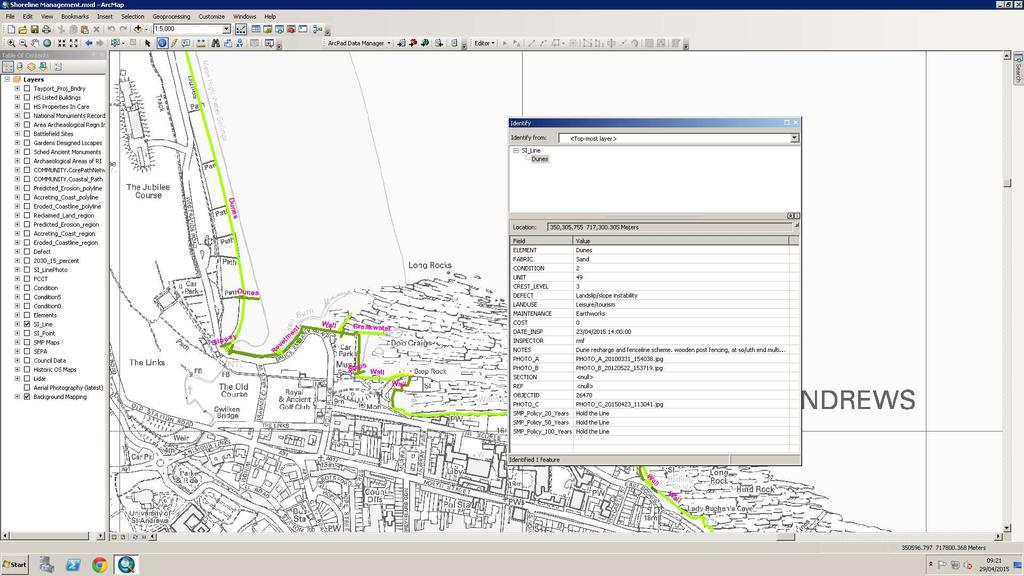
6 1.0 Introduction This report reviews the current requirement for a national coastal defence asset database in order to establish a baseline from which to identify the current presence, absence and, if possible, condition of the artificial structures and natural landforms in place that serve a coastal protection function be it coastal erosion or flooding. The aim of such an exercise is to have in place high level but achievable targets so that the Scottish Government, its agencies and Local Authorities can all appreciate a national overview of the current defence resource. They will thus be in a better position to assess the level of protection afforded by built and natural defences within any strategic requirement to support the sustainable management of assets in the face of climate change. Such a coastal erosion and flooding database allows an understanding of the present performance of the resource to be developed and its likely future performance assessed (see Appendix A for an example). We need to understand the asset s exposure to pressure, construction materials, present condition and likely future deterioration. In the absence of an assessment of condition and the likely performance of coastal erosion and flood defence assets, it is impossible to support effective decision-making for the management of erosion and flood risk. 2.0 Coastal defences 2.1 Attributes to be included for coastal defences Key to any asset condition assessment is to develop a standard template that allows a rapid and objective visual assessment of its condition. This report follows the 5 point scale used by the EA for general asset condition assessment (Environment Agency, 2006): Grade Rating Description 1 Very Good Cosmetic defects that will have no effect on performance 2 Good Minor defects that will not reduce the overall performance of the asset 3 Fair Defects that could reduce performance of the asset 4 Poor Defects that would significantly reduce the performance of the asset. Further investigation needed 5 Very Poor Severe defects resulting in complete performance failure An indicative selection of the types of influences that might affect the above visual assessment are listed in Appendix B (from Environment Agency, 2006). 2.2 Built coastal defences Built coastal defences are commonplace on Scotland s coast and may have been constructed for a variety of purposes including protection of the coast from wave impact, erosion and overtopping, coastal flood defences, port and harbour construction, road and railtrack support and protection, and beach nourishment for recreational purposes amongst others. Irrespective of their original position and function, and in common with other structures constructed at, or close to, MHWS, it may be that they are now exposed at, or close to, MHWS and thus should be regarded as part of the asset resource. 3
7 The types of information that can be regarded as key to a national database are attributes such as: presence/absence; protection type; linear extent; height above OD; structure age; condition and evidence of deterioration; estimate of future design life; planned renewal date (if known). These attributes are stylised into table 3.1. A good working example of the type and quality of Local Authority derived data aimed at capturing the type and location of the defence assets is provided in Appendix A. Table 2.1: Attributes to be included within the Built Coastal Defences Database. Name Information contained Data type ID Unique Identifier within NCCA. Based on: Cell - Sub Cell - Element# ID Code Essential part of NCCA Start point Coordinates BNG coordinates Yes End point Coordinates BNG coordinates Yes Asset type Concrete wall/wooden groyne Select from a predefined menu Structure Condition 1-5 scoring system Predefined menu No Crest Altitude + position Min, Max, Representative mod + m from MHWS No Level of protection What return period the altitude (above) refers to. Predefined level No Structure age Date of construction (if known) Date field No Last check maintenance Date Date field No Checked by Name of inspecting Engineer Free text field No Owner type Private / LA owned / Transport Scotland Predefined menu Further Info LA contact / Data provider Free text field No Notes Photo Cracking of masonry joints etc. Photo A, B Free text field Free image field 2.3 Natural coastal defences Natural coastal defences are defined as the beaches, dunes and saltmarshes that are commonplace on Scotland s coast and which serve a useful protection function for any assets that lie landward. Although primarily regarded as recreational or aesthetic assets, their role as important coastal protection structures is increasingly acknowledged, albeit that this role has been underestimated in the past. Where these constitute a series of non-active beach ridges, dune ridges or machair that were originally constructed close to MHWS but became isolated inland due to subsequent accretion, it may be that they have over time become exposed at, or close to MHWS on account of erosion, and so should be regarded as part of the asset resource (ie. emerged or raised beaches and dunes). The types of information that can be regarded as key to a national database are attributes such as: presence/absence; asset type; linear extent; height above OD; structure age; condition and evidence of deterioration; land use pressures etc. These attributes are stylised into table 4.2. Yes Yes No No No 4
8 ID Scotland s National Coastal Change Assessment Table 4.2: Attributes to be included within the Built Coastal Defences Database. Name Information contained Data type Unique Identifier within NCCA. Based on: Cell - Sub Cell - Element# ID Code Essential part of NCCA Start point Coordinates BNG coordinates Yes End point Coordinates BNG coordinates Yes Asset type Structure Condition / index of robustness Crest Altitude + position Level of protection Crest width E.g. sand dune, shingle beach Predefined menu, multiple responses 1-5 scoring system Predefined menu No Min, Max, Representative mod + m from MHWS No What return period the altitude (above) refers to Predefined level No Width of crest at MHWS numeric value, m width above nominated flood level? No Pressures E.g. grazing, extraction Select from a predefined menu No Owner type Private / LA owned / Transport Scotland Select from a predefined menu Further Info LA contact / Data provider Free text field No Yes Yes No Notes Photo Dune recharge site (date) Free text field No 2.5 A national coastal defence database There is a clear need for a national coastal defence database that would allow all levels of Government to understand the present extent and condition of the defence asset resource in order to assess any present and future requirements. For example, there is a need to understand the asset s exposure to pressure, construction materials, present condition and likely future deterioration. In the absence of an assessment of condition and the likely performance of coastal erosion and flood defence assets, it will be problematic to support effective decision-making for the management of future erosion and flood risk. At present the local data bases are patchy and incomplete and a fully functional and comprehensive national data base does not yet exist. 5
9 Appendix A: Fife Council s datasets Some examples of good data recording practice to comprise a useful dataset by Fife Council. Note that not all Local Authorities have such a comprehensive data set on their built and natural coast protection assets.
10 7
11 8
12 9


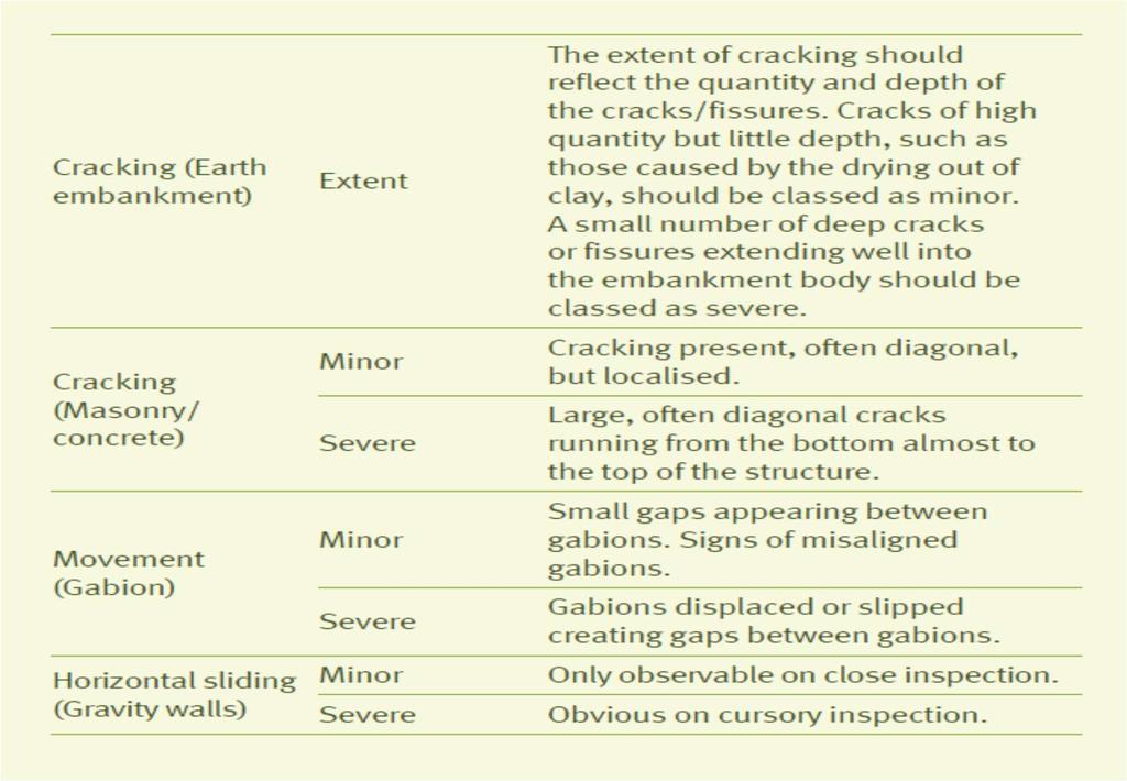
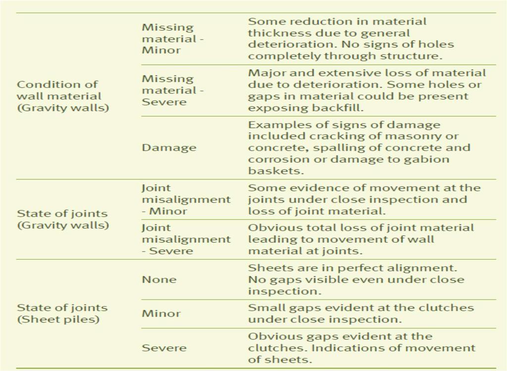
13 Appendix B: Potential influences on visual assessments (from Environment Agency 2006)
14 11
15 References Environment Agency (2006) Managing Flood Risk, Condition Assessment Manual. Document Reference 166_03_SD pp. 12

16 Scotland s centre of expertise for waters CREW Facilitation Team James Hutton Institute Craigiebuckler Aberdeen AB15 8QH Scotland UK Tel: +44 (0) enquiries@crew.ac.uk CREW is a Scottish Government funded partnership between the James Hutton Institute and Scottish Universities.
Dynamic Coast. Coastal erosion / Management Briefing to THC
 Dynamic Coast Coastal erosion / Management Briefing to THC What is Dynamic Coast? Dynamic Coast is a Scottish Government project, funded by CREW, managed by SNH, with a research team from the University
21 st Century Coastal Adaptation - Can Scotland Deliver?
 21 st Century Coastal Adaptation - Can Scotland Deliver? Present day significant erosion in Scotland More than 10m of erosion or faster than 0.5m/yr www.dynamiccoast.com Jim Hansom 1, Alistair Rennie 2,
Natural Susceptibility to Coastal Erosion: Methodology and Mapping Summary
 Natural Susceptibility to Coastal Erosion: Methodology and Mapping Summary. Introduction The Flood Risk Management (Scotland) Act 2009 (FRM Act) introduced a coordinated and partnership approach to how
Flood Risk Mapping and Forecasting in England
 Flood Risk Mapping and Forecasting in England Mark Franklin Environment Agency, England NORDESS Workshop on Risk Assessment and Acceptable Risk Outline Flood risk in England Who we are and how we work
Ministry of Health and Long-Term Care Geographic Information System (GIS) Strategy An Overview of the Strategy Implementation Plan November 2009
 Strategy An Overview of the Strategy Implementation Plan November 2009") Ministry of Health and Long-Term Care Geographic Information System (GIS) Strategy An Overview of the Strategy Implementation Plan November 2009 John Hill, Health Analytics Branch Health System Information
Ministry of Health and Long-Term Care Geographic Information System (GIS) Strategy An Overview of the Strategy Implementation Plan November 2009 John Hill, Health Analytics Branch Health System Information
Scenarios for the NI coast in the 21 st Century
 Scenarios for the NI coast in the 21 st Century Prof Julian Orford Geography, Archaeology & Palaeoecology Queen s University, Belfast Challenging perspective Living by the coast is good for your health!
Map Introduction: South Uist Map 1
 96 Map Introduction: Map This map section covers part of the south coast of, including the head of the causeway which links the island to Eriskay. It extends from South Glen Dale to Taobh a'caolas. There
A Generic Coastal Erosion Hazard Zoning for Tasmania. Chris Sharples, Hannah Walford & Luke Roberts April 2014
 A Generic Coastal Erosion Hazard Zoning for Tasmania Chris Sharples, Hannah Walford & Luke Roberts April 2014 Why do we need comprehensive coastal erosion hazard zones for Tasmania? Roches Beach 2011 Why
Protecting the Storm Damage Prevention and Flood Control Interests of Coastal Resource Areas
 Protecting the Storm Damage Prevention and Flood Control Interests of Coastal Resource Areas Presented by: Massachusetts Department of Environmental Protection & Massachusetts Office of Coastal Zone Management
Presentation Outline. Project Overview. Sea Level Rise Assessment & Decision Tools. Community Engagement. Tina Whitman, Friends of the San Juans
 Healthy Beaches for People & Fish Sea Level Rise Adaptation Tools for San Juan County, WA Tina Whitman & Andrea MacLennan December 10, 2015 Presentation Outline Project Overview Tina Whitman, Friends of
TECHNIQUES FOR ASSESSING COASTAL HAZARD AREAS FOR THE GISBORNE DISTRICT COAST
 TECHNIQUES FOR ASSESSING COASTAL HAZARD AREAS FOR THE GISBORNE DISTRICT COAST July 1994 C.R. 1994/12 Jeremy G Gibb 2009 All rights reserved. This work is entitled to the full protection given by the Copyright
IMA s ROLE IN COASTAL AND OCEAN GOVERNANCE IN TRINIDAD AND TOBAGO
 IMA s ROLE IN COASTAL AND OCEAN GOVERNANCE IN TRINIDAD AND TOBAGO Presented by Rahanna Juman, Deputy Director (Ag.) About the Institute of Marine Affairs Institute of Marine Affairs (IMA) was established,
SHORELINE AND BEACH PROCESSES: PART 2. Implications for Coastal Engineering
 SHORELINE AND BEACH PROCESSES: PART 2 Implications for Coastal Engineering Objectives of the lecture: Part 2 Show examples of coastal engineering Discuss the practical difficulties of ocean engineering
Applying GIS to Coastal Management in Cork Harbour: the Corepoint experience
 Applying GIS to Coastal Management in Cork Harbour: the Corepoint experience Kathrin Köpke University College Cork, Ireland Thematic Conference: THE WATERFRONT MANAGEMENT AND GI (IT), 14 th -18 th November
Coastal Viewer Mapping Application:
 Coastal Viewer Mapping Application: MAPPING OF COASTAL PUBLIC PROPERTY, THE COASTAL PROTECTION ZONE BOUNDARIES AND AUDITING OF STRUCTURES ON THE COASTAL PUBLIC PROPERTY 15 May 2014 INTEGRATED COASTAL MANAGEMENT
INSPIRing effort. Peter Parslow Ordnance Survey December Various European approaches to managing an SDI
 INSPIRing effort Peter Parslow Ordnance Survey December 2015 Various European approaches to managing an SDI WHAT IS INSPIRE? A European Union Directive A community effort: http://inspire.ec.europa.eu/
Northern Sea Wall, Kent
 Northern Sea Wall, Kent The North Kent Shoreline Management Plan (SMP) defines management units along the North Kent coast ranging from Management Unit 4a - 1A at the Isle of Grain, to Management Unit
26 Coastal erosion and accretion
 26 Coastal erosion and accretion 26.1 Rate of erosion and accretion 26.2 Length of protected coastline 26.3 Volume of sand nourishment Fig. 26.1: Coastline dynamics of the South East Baltic region Key
RISC-KIT: EWS-DSS Hotspot Tool
 RISC-KIT: EWS-DSS Hotspot Tool Robert McCall Ap van Dongeren Deltares www.risckit.eu This project has received funding from the European Union s Seventh Programme for Research, Technological Development
TOWARDS CLIMATE-RESILIENT COASTAL MANAGEMENT: OPPORTUNITIES FOR IMPROVED ICZM IN BELIZE
 TOWARDS CLIMATE-RESILIENT COASTAL MANAGEMENT: OPPORTUNITIES FOR IMPROVED ICZM IN BELIZE CHANTALLE SAMUELS Coastal Zone Management Authority and Institute The Caribbean Community Climate Change Centre VULNERABILITY
Coastal Systems and Landscapes 3 days
 AS Level Geography WJEC Coastal Systems and Landscapes 3 days This course is for Welsh schools. This in-depth course prepares students for the physical fieldwork focusing on the Coastal option, for Section
Wainui Beach Management Strategy (WBMS) Summary of Existing Documents. GNS Tsunami Reports
 Summary of Existing Documents. GNS Tsunami Reports") Wainui Beach Management Strategy (WBMS) Summary of Existing Documents GNS Tsunami Reports a) Review of Tsunami Hazard and Risk in New Zealand ( National Risk Report ) b) Review of New Zealand s Preparedness
Wainui Beach Management Strategy (WBMS) Summary of Existing Documents GNS Tsunami Reports a) Review of Tsunami Hazard and Risk in New Zealand ( National Risk Report ) b) Review of New Zealand s Preparedness
Coastal Management on the Isle of Wight
 Coastal Management on the Isle of Wight Setting the scene The Isle of Wight has 65 miles of spectacular coastline, 28 miles of which are designated Heritage Coast. This varied coastline is one of the Island
Map Introduction: South Uist Map 6
 6 Map Introduction: Map 6 This map section covers part of the west coast of. It extends from Cill Donnain to Ardvule and onwards to Ormacleit. There is no modern settlement within the coastal zone but
CHAPTER 22 GEOGRAPHIC INFORMATION SYSTEMS
 CHAPTER 22 GEOGRAPHIC INFORMATION SYSTEMS PURPOSE: This chapter establishes the administration and use of to improve the quality and accessibility of Department s spatial information and support graphical
Seaton to Seaton Hole SUMMARY OF PREFERRED PLAN RECOMMENDATIONS AND JUSTIFICATION
 Location reference: Policy Unit reference: Plan: Seaton to Seaton Hole 6a29 and 6a30 SUMMARY OF PREFERRED PLAN RECOMMENDATIONS AND JUSTIFICATION The large number of properties and assets at risk in the
Flood Map. National Dataset User Guide
 Flood Map National Dataset User Guide Version 1.1.5 20 th April 2006 Copyright Environment Agency 1 Contents 1.0 Record of amendment... 3 2.0 Introduction... 4 2.1 Description of the Flood Map datasets...4
Natural flood management summary: Methodology and mapping
 Natural flood management summary: Methodology and mapping 1. Introduction The Flood Risk Management (Scotland) Act (FRM Act) introduced a co-ordinated and partnership approach to how we tackle flood risk
15 March 2010 Re: Draft Native Vegetation of the Sydney Metropolitan Catchment Management Authority Area GIS layers and explanatory reports
 SYDNEY COASTAL COUNCILS GROUP Inc. C/- City of Sydney Council Level 14, 456 Kent Street GPO Box 1591, SYDNEY NSW 2001 Phone: (02) 9246 7791 Facsimile: (02) 9265 9660 Email: info@sydneycoastalcouncils.com.au
Spatial Planning & Climate Change
 Spatial Planning & Climate Change A GRIP Approach Joseph Scott, Glasgow & Clyde Valley Strategic Development Plan Authority, Scotland Today s presentation Context Spatial Planning & Climate Change Exploring
Delta Flood Protection Strategy Update. May 16, 2016
 Delta Flood Protection Strategy Update May 16, 2016 Presentation Overview 1. Background 2. Understanding the Dike Reaches/Issues 3. Future Dike Improvements 4. Next Steps Boundary Bay Village March 10,
Connecticut Coastal Management Program
 Connecticut Coastal Management Program Fact Sheet for SHORELINE FLOOD AND EROSION CONTROL STRUCTURES What are Shoreline Flood and Erosion Control Structures? The Connecticut General Statutes (CGS) define
Protection of Coasts
 Protection of Coasts [Coastal Zones] Jan van de Graaff Delft University of Technology 1 Coastal Zone: many definitions here: rather narrow strip of land adjacent to sea or large inland water (say: 150
6. SURVEY MAPS OF THE ISLE OF ARRAN MAP 1: DRUMADOON POINT TO AIRD NAN RON
 6. SURVEY MAPS OF THE ISLE OF ARRAN MAP 1: DRUMADOON POINT TO AIRD NAN RON Hinterland Geology and Coastal Geomorphology: Both Permian sandstone and Triassic mudstones are represented in this coastal section.
United States Multi-Hazard Early Warning System
 United States Multi-Hazard Early Warning System Saving Lives Through Partnership Lynn Maximuk National Weather Service Director, Central Region Kansas City, Missouri America s s Weather Enterprise: Protecting
BUTE MAP 6: GARROCH HEAD to STRAVANNAN BAY
 BUTE MAP 6: GARROCH HEAD to STRAVANNAN BAY Hinterland Geology and Coastal Geomorphology: Old Red Sandstone and lavas form the principal base deposits and are overlain by marine deposits towards Port Dornoch.
OUR COASTAL FUTURES. A Strategy for the Sustainable Development of the World s Coasts.
 OUR COASTAL FUTURES A Strategy for the Sustainable Development of the World s Coasts www.futureearthcoasts.org Iqaluit, Nunavut, Canada. Photo by Don Forbes Coastal zones are the frontline in our global
Newsroom: 'Shifting Seas' Symposium at RWU Law
 Roger Williams University DOCS@RWU Life of the Law School (1993- ) Archives & Law School History 11-16-2012 Newsroom: 'Shifting Seas' Symposium at RWU Law Roger Williams University School of Law Follow
Coastal Guide ICZM Information System
 Coastal Guide ICZM Information System 1. Key data Project title: Implementing alternative strategies in Irish beach and dune management: involvement in sustainable coastal development Country: Ireland
New Zealand s Next Top Model: integrating tsunami modelling into land use planning
 New Zealand s Next Top Model: integrating tsunami modelling into land use planning Wendy Saunders (MZNZPI), Gegar Prasetya, Graham Leonard GNS Science, Lower Hutt, w.saunders@gns.cri.nz In April 2011 a
Developing urban ecosystem accounts for Great Britain. Emily Connors Head of Natural Capital Accounting Office for National Statistics (UK)
") Developing urban ecosystem accounts for Great Britain Emily Connors Head of Natural Capital Accounting Office for National Statistics (UK) UN 2014 UN 2014 ONS 2017 UK motivation 54% 82% 5,900 Of the world
Developing urban ecosystem accounts for Great Britain Emily Connors Head of Natural Capital Accounting Office for National Statistics (UK) UN 2014 UN 2014 ONS 2017 UK motivation 54% 82% 5,900 Of the world
Realizing benefits of Spatial Data Infrastructure A user s perspective from Environment Agency - Abu Dhabi
 Realizing benefits of Spatial Data Infrastructure A user s perspective from Environment Agency - Abu Dhabi Anil Kumar Director, Environment Information Management 26 April 2012 Geospatial World Forum,
Climate Change and the Implications for the Management of Coastal Landslides. James Houghton Senior Geotechnical Engineer Isle of Wight Council
 Climate Change and the Implications for the Management of Coastal Landslides James Houghton Senior Geotechnical Engineer Isle of Wight Council Outline Background to landsliding on the Isle of Wight Current
THE SEVILLE STRATEGY ON BIOSPHERE RESERVES
 THE SEVILLE STRATEGY ON BIOSPHERE RESERVES 1 VISION FOR BIOSPHERE RESERVES IN THE 21 ST CENTURY The international Seville Conference on Biosphere Reserves, organised by UNESCO, adopted a two-pronged approach,
Proposed Scope of Work Village of Farmingdale Downtown Farmingdale BOA Step 2 BOA Nomination Study / Draft Generic Environmental Impact Statement
 Proposed Scope of Work Village of Farmingdale Downtown Farmingdale BOA Step 2 BOA Nomination Study / Draft Generic Environmental Impact Statement The scope of work that follows incorporates and covers
The Governance of Land Use
 The Governance of Land Use Country fact sheet Czech Republic The planning system Levels of government and their responsibilities The Czech Republic is a unitary state with 3 levels of government: the national
Economic and Social Council
 United Nations Economic and Social Council Distr.: General 18 July 2016 Original: English Committee of Experts on Global Geospatial Information Management Sixth session New York, 3-5 August 2016 Item 2
BUTE MAP 2: ARDMALEISH POINT to ARDBEG
 BUTE MAP 2: ARDMALEISH POINT to ARDBEG Hinterland Geology and Coastal Geomorphology: Dalradian schists continue to dominate this coastal region. The Kames Bay area is dominated by Dunoon Phylites which
Looking after Lyme Regis
 Looking after Lyme Regis Lyme Regis sits on one of the most unstable stretches of coastline in the country. The highly active and unstable nature of the land which Lyme Regis is built upon can easily be
INTEGRATION OF BUILT AND NATURAL ENVIRONMENTAL DATASETS WITHIN NATIONAL SDI INITIATIVES
 UNITED NATIONS E/CONF.97/6/IP. 38 and IP. 39 ECONOMIC AND SOCIAL COUNCIL Seventeenth United Nations Regional Cartographic Conference for Asia and the Pacific Bangkok, 18-22 September 2006 Item 7 of the
Coastal Systems and Landscapes 3 days
 AS Level Geography Eduqas Coastal Systems and Landscapes 3 days Deliver two days of fieldwork within an inspiring physical environment. Prepare AS level students for Paper 1 Section B: Fieldwork Investigation
Aim and objectives Components of vulnerability National Coastal Vulnerability Assessment 2
 ASSESSING THE UTILITY OF GEOMORPHIC SENSITIVITY MAPPING ON THE ILLAWARRA COAST Pamela Abuodha, Christina Baker, Chris Sharples, Darren Skene and Colin Woodroffe Geoquest Research Centre, University of
Using Remote Piloted Aircraft for Seawall Condition Assessment
 Using Remote Piloted Aircraft for Seawall Condition Assessment Moreton Bay Regional Council Shamim Yazdani Senior Engineer - Stormwater Planning DJI Industries Phantom FC-40 remotely-piloted aircraft 1
Source Protection Zones. National Dataset User Guide
 Source Protection Zones National Dataset User Guide Version 1.1.4 20 th Jan 2006 1 Contents 1.0 Record of amendment...3 2.0 Introduction...4 2.1 Description of the SPZ dataset...4 2.1.1 Definition of the
Objective To enhance the management of defended coastlines through integration of coastal erosion and flood risk models
 School of Oriental and African Studies, 4 th October 2011 Practitioner workshop on asset management Shoreline evolution for flood risk assessment Dr Stuart Stripling EPSRC Grant: EP/FP202511/1 FRMRC2 WP4.3
THE FLOODRESILIENCITY PROJECT
 THE FLOODRESILIENCITY PROJECT Tony Maguire, Senior Executive Engineer, Environment & Engineering Department, Dublin City Council. EWA SYMPOSIUM IFAT 2010 Note all photos & graphics FRC Project; Dublin
ICSM delivering benefits through collaboration
 ICSM delivering benefits through collaboration Russell Priebbenow Chair and Queensland Member Australia and New Zealand s Intergovernmental Committee on Surveying and Mapping Overview Who is ICSM & why
Built Heritage & Archaeology Crown copyright. All rights reserved. Historic Scotland Licence No [2007] a
![Built Heritage & Archaeology Crown copyright. All rights reserved. Historic Scotland Licence No [2007] a](/thumbs/92/110316004.jpg "Built Heritage & Archaeology Crown copyright. All rights reserved. Historic Scotland Licence No [2007] a") : Tràigh an Tobair Fhuair to Meall Lamalum This map section stretches along s west coast from Tràigh an Tobair Fhuair to Meall Lamalum. The entire coastline comprises a rock platform, with the exception
: Tràigh an Tobair Fhuair to Meall Lamalum This map section stretches along s west coast from Tràigh an Tobair Fhuair to Meall Lamalum. The entire coastline comprises a rock platform, with the exception
The UK Flood Forecasting Centre
 Storm Surge Networking Forum, Venice: Tuesday 19 th November 2013 The UK Flood Forecasting Centre Dave Cox - Senior Hydrometeorologist FFC Exeter, England. In My talk today I will cover: Ü Overview of
Draft for Discussion 11/11/2016
 Coastal Risk Consulting (CRC) Climate Vulnerability Assessment for Village of Key Biscayne Deliverable 1.1 in Statement of Work. Preliminary Vulnerability Assessment Identifying Flood Hotspots Introduction...
AS & A2 Geography for OCR. Tailored Courses. Slapton Ley
 AS & A2 Geography for OCR Tailored Courses Slapton Ley Please visit http://www.field-studies-council.org/outdoorclassroom/geography/aqa/ for alternative A-level AQA programmes OVERVIEW Since the assessment
Professors Dean and Dalrymple are also authors of the well-known Water Wave Mechanics for Engineers and Scientists.
 COASTAL PROCESSES The world s coastlines, dividing land from sea, are geological environments unique in their composition and the physical processes affecting them. Humans have been building structures
For the multiple-choice questions, completely fill in the circle alongside the appropriate answer.
 DRAFT SPECIMEN MATERIAL A-level GEOGRAPHY Paper 1 Physical geography Specimen Question Paper Time allowed: 2 hours 30 minutes Materials For this paper you must have: a pencil a rubber a ruler. You may
The Coast: Beaches and Shoreline Processes
 1 2 3 4 5 6 7 8 9 The Coast: es and Shoreline Processes Trujillo & Thurman, Chapter 10 Oceanography 101 Chapter Objectives Recognize the various landforms characteristic of beaches and coastal regions.
Reliability Assessment Electric Utility Mapping. Maged Yackoub Eva Szatmari Veridian Connections Toronto, October 2015
 Reliability Assessment Electric Utility Mapping Maged Yackoub Eva Szatmari Veridian Connections Toronto, October 2015 Agenda Introduction About Veridian Connections Veridian s GIS platform Reliability
Implementation Status & Results Mozambique Cities and Climate Change (P123201)
") Public Disclosure Authorized Public Disclosure Authorized The World Bank Implementation Status & Results Mozambique Cities and Climate Change (P123201) Operation Name: Cities and Climate Change (P123201)
Public Disclosure Authorized Public Disclosure Authorized The World Bank Implementation Status & Results Mozambique Cities and Climate Change (P123201) Operation Name: Cities and Climate Change (P123201)
The Coast: Beaches and Shoreline Processes Trujillo & Thurman, Chapter 10
 The Coast: es and Shoreline Processes Trujillo & Thurman, Chapter 10 Oceanography 101 Chapter Objectives Recognize the various landforms characteristic of beaches and coastal regions. Identify seasonal
EcoServ-GIS. EcoServ GIS Stage I. Why EcoServ GIS? 17/12/2012
 EcoServ-GIS Ecosystem Services Mapping: A Wildlife Trust GIS Toolkit to map ecosystem services at a county scale Dr Jonathan Winn Living Landscape Coordinator Durham Wildlife Trust Dr Chloe Bellamy Ecosystem
REGIONAL SDI DEVELOPMENT
 REGIONAL SDI DEVELOPMENT Abbas Rajabifard 1 and Ian P. Williamson 2 1 Deputy Director and Senior Research Fellow Email: abbas.r@unimelb.edu.au 2 Director, Professor of Surveying and Land Information, Email:
Floods 2014 a wake up call to natural hazards
 Floods 2014 a wake up call to natural hazards Floods affected 119 municipalities (out of 165) 22% of total population affected by floods More than 30 municipalities sustained extensive damage 57 lives
Norwegian spatial data infrastructure supporting disaster risk management Norwegian Mapping Authority
 Norwegian spatial data infrastructure supporting disaster risk management Norwegian Mapping Authority Arvid Lillethun, Norwegian Mapping Authority Land and Poverty 2018 Conference, World Bank 19.-23. March
Use of Elevation Data in NOAA Coastal Mapping Shoreline Products. Coastal GeoTools April 1, 2015
 Use of Elevation Data in NOAA Coastal Mapping Shoreline Products Coastal GeoTools April 1, 2015 - NOAA s Coastal Mapping Program & CUSP - Shoreline Uses, Delineation Issues, Definitions - Current Extraction
Appendix F Shoreline Interactions & Responses
 Appendix F Shoreline Interactions & Responses - Fi - Appendix F Shoreline Interactions & Responses APPENDIX F - CONTENTS Page F1 INTRODUCTION 1 F2 ASSESSMENT OF COASTAL DEFENCES 2 F2.1 Introduction 2 F2.2
A Level Geography Cambridge International Content Programme For teaching from September 2016
 A Level Geography Cambridge International Content Programme For teaching from September 2016 is located on the Start Bay coast in South Devon and is surrounded by Slapton Ley National Nature Reserve. The
What s the problem? A Modern Odyssey in Search of Relevance. The search for relevance. Some current drivers for new services. Some Major Applications
 A Modern Odyssey in Search of Relevance FIG Working Week, Athens, 24 May 2004 Paul Kelly ANZLIC Executive Director The search for relevance 1. New expectations for spatial services 2. Are we ready to meet
Term Knowledge Using and applying Grade Criteria Autumn 1 Assessment window October Natural hazards pose major risks to people and property.
 Assessment Schedule Year 9 2015/6 Term Knowledge Using and applying Grade Criteria Autumn 1 Assessment window October 2015 3.1.1.2 Tectonic Natural hazards pose major risks to people and property. Definition
Summary Description Municipality of Anchorage. Anchorage Coastal Resource Atlas Project
 Summary Description Municipality of Anchorage Anchorage Coastal Resource Atlas Project By: Thede Tobish, MOA Planner; and Charlie Barnwell, MOA GIS Manager Introduction Local governments often struggle
US National Spatial Data Infrastructure A Spatial Framework for Governance and Policy Development to Enable a Location-Based Digital Ecosystem
 GeoPlatform Workshop 7 Dec 2016, Department of the Interior Washington, D.C. US National Spatial Infrastructure A Spatial Framework for Governance and Policy Development to Enable a Location-Based Digital
Superstorm Sandy Willis Re s post-event field damage survey preliminary report
 HURRICANE DAMAGE SURVEY REPORT event November 8, 2012 Superstorm Sandy Willis Re s post-event field damage survey preliminary report Immediately after Sandy s landfall, representatives of Willis Re s Catastrophe
Key Indicators for Territorial Cohesion and Spatial Planning in Preparing Territorial Development Strategies
 ESPON Evidence in a North European Context Challenges and Opportunities for Territorial Development and Cohesion in a North European Macro Region, 10-11 April, 2014, Vilnius, Lithuania Key Indicators for
Dorset Coastal Explorer Planning
 Dorset Coastal Explorer Planning Please read this information carefully. If you wish to proceed after reading this information you must signify your agreement to the following conditions of access by selecting
Ludington Project July 1993
 Ludington Project July 1993 DLH Photos by Marge Beaver Nov. 1984 Photo by DLHolmberg Ludington Project July 1986 July 2005 19 Years Later Photos by DLHolmberg Ludington Project Nov.1985 July 2005 20 Years
Landscape Systems: Coasts 3 days
 AS Level Geography Edexcel Landscape Systems: Coasts 3 days Deliver two days of fieldwork within an inspiring physical environment covering all the recommended themes in depth. Prepare AS level students
Sea Level Space Watch: Service Offering
 Space for Smarter Government Programme Sea Level Space Watch: Service Offering General Sea Level Space Watch : Operational service developed to support national flood defence planning. Systematically updated
Section 2. Indiana Geographic Information Council: Strategic Plan
 Section 2. Indiana Geographic Information Council: Strategic Plan Introduction A geographic information system (GIS) is an automated tool that allows the collection, modification, storage, analysis, and
User Guide: RADON POTENTIAL DATASET - England and Wales
 User Guide: RADON POTENTIAL DATASET - England and Wales This document provides information for users of the joint HPA-BGS RADON POTENTIAL DATASET for England and Wales. 1. Background to joint Health Protection
Phillip Island Nature Parks Coastal Process Study 8 October 2014
 Phillip Island Nature Parks Coastal Process Study 8 October 2014 Project Overview Coastal Geology Basaltic and fragmented lavas, granite at Pyramid Rock and Cape Woolamai Weathered basalt (>10m thick)
The problem of the use of ambiguous terms in Tasmanian coastal planning policy documents for defining appropriate coastal development zones
 The problem of the use of ambiguous terms in Tasmanian coastal planning policy documents for defining appropriate coastal development zones Chris Sharples, May 2012 Introduction Coastal planning and policy
Assessing, Monitoring, and Defending Coral Reefs with GIS
 Assessing, Monitoring, and Defending Coral Reefs with GIS Dr. Rich Snow and Dr. Mary Snow Applied Aviation Sciences Embry-Riddle Aeronautical University Daytona Beach, Florida It is estimated that 60%
EcoServ-GIS. Ecosystem Services Mapping: A Wildlife Trust GIS Toolkit to map ecosystem services at a county scale
 EcoServ-GIS Ecosystem Services Mapping: A Wildlife Trust GIS Toolkit to map ecosystem services at a county scale Dr Jonathan Winn Living Landscape Coordinator Durham Wildlife Trust Dr Chloe Bellamy Ecosystem
Cell 1 Regional Coastal Monitoring Programme Coastal Walkover Inspections 2010
 Cell 1 Regional Coastal Monitoring Programme Coastal Walkover Inspections 2010 East Riding of Yorkshire Council Final Report November 2010 Contents Abbreviations and Acronyms Asset Condition Grades Glossary
BalticBOOST Appendix 1, WP 3.3 Deliverable 1 Final report 14 February 2017
 Theme 1: Biodiversity This is a deliverable from the BalticBOOST project that was coordinated by HELCOM and co-financed by the European Union in 2015-2016 as part of the programme DG ENV/MSFD Action Plans/2016.
DELIVERING ECOSYSTEM- BASED MARINE SPATIAL PLANNING IN PRACTICE
 DELIVERING ECOSYSTEM- BASED MARINE SPATIAL PLANNING IN PRACTICE A first assessment for the UK and Ireland January 08 GLOBAL WARMING IMAGES / WWF ABOUT WWF WWF is the world s leading independent conservation
GEO Geohazards Community of Practice
 GEO Geohazards Community of Practice 1) Co-Chair of GHCP With input from: Stuart Marsh, GHCP Co-Chair Francesco Gaetani, GEO Secretariat and many GHCP contributors 1) Nevada Bureau of Mines and Geology
South Florida Coastal Storm Surge and Mapping Study
 South Florida Coastal Storm Surge and Mapping Study Presented by Christopher Bender, Ph.D., P.E., D.CE June 2, 2015 Presentation Overview FEMA risk studies outline Overview South Florida surge study Work
UN GGIM and National SDI Strategy
 MSDI Open Forum on 26 th January 2016 Contributing to the successful delivery of MSDI UN GGIM and National SDI Strategy Hiroshi Murakami Deputy Administrator Geospatial Information Authority of Japan Geospatial
Economic and Social Council 2 July 2015
 ADVANCE UNEDITED VERSION UNITED NATIONS E/C.20/2015/11/Add.1 Economic and Social Council 2 July 2015 Committee of Experts on Global Geospatial Information Management Fifth session New York, 5-7 August
INTEGRATED COASTAL SEDIMENT MANAGEMENT AT PHYSIOGRAPHIC UNIT SCALE, AN APPLICATION IN VERSILIA LITTORAL (TUSCANY, ITALY)
") INTEGRATED COASTAL SEDIMENT MANAGEMENT AT PHYSIOGRAPHIC UNIT SCALE, AN APPLICATION IN VERSILIA LITTORAL (TUSCANY, ITALY) Damiano Scarcella (Msc) Sergio Cappucci (PhD) Andrea Taramelli (PhD) OUTLINE Sediment
INTEGRATED COASTAL SEDIMENT MANAGEMENT AT PHYSIOGRAPHIC UNIT SCALE, AN APPLICATION IN VERSILIA LITTORAL (TUSCANY, ITALY) Damiano Scarcella (Msc) Sergio Cappucci (PhD) Andrea Taramelli (PhD) OUTLINE Sediment
Map 9: Ayrshire Coast: Stevenston Pier to Barassie Map Content Descriptions
 Map 9: Ayrshire Coast: Stevenston Pier to Barassie Map Content Descriptions 1. Built Heritage and Archaeology A total of thirteen sites were recorded in the area covered by Map 9. Of these five were previously
Economic and Social Council
 United Nation E/C.20/2012/4/Add.1 Economic and Social Council Distr.: General 2 July 2012 Original: English Committee of Experts on Global Geospatial Information Management Second session New York, 13-15