Climate Change and the Implications for the Management of Coastal Landslides. James Houghton Senior Geotechnical Engineer Isle of Wight Council
|
|
|
- Gyles McKenzie
- 5 years ago
- Views:
Transcription
1 Climate Change and the Implications for the Management of Coastal Landslides James Houghton Senior Geotechnical Engineer Isle of Wight Council
2 Outline Background to landsliding on the Isle of Wight Current management strategies Specific projects aimed at reducing landslide risk


3 The Isle of Wight Coastline -Complex and Varied
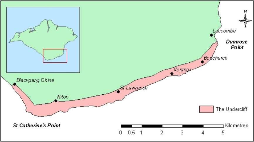
4 The Undercliff

5 The Undercliff 12km 500m
6 Simplified Ventnor Landslide Model

7 Landslip at Bonchurch
8 Loss of Road at Niton

9 GIS Map Data, Ventnor Undercliff Ordnance Survey Base map Aerial photograph
10 Landslide Susceptibility in the Undercliff

11 Mean Monthly Effective Rainfall Change Scenarios at Ventnor From Halcrow, 2001
12 IWCCE Key Responsibilities Shoreline Management & Coast Protection Coastal, landslide and cliff monitoring and management Ground stability engineering Planning liaison over coastal, geotechnical and environmental issues Harbour management Dissemination of information and public relations through the Isle of Wight Coastal Visitors Centre
13 Isle of Wight Undercliff Landslide Management Strategy Undercliff Landslide Management Strategy (since 1992) Management Committee Planning control Building control Engineering measures Monitoring Planning guidance map Codes of good practice Coastal protection Forecast Drainage Early warning Loss mitigation
14 Isle of Wight Undercliff Landslide Management Strategy Action 1) Engineering measures (coastal protection works and drainage etc.) 2) Public education and information 3) The control of water in the ground 4) Avoidance of seriously affected areas 5) Further monitoring and research Example Construction of the Castlehaven coastal protection and land drainage scheme Opening of Coastal Visitors Centre in 1998 Advice to homeowners leaflets (periodically updated & reissued) E.g. The Graben, Newport Road, Upper Ventnor Ongoing ground movement monitoring, European funded projects, etc.

15 1) Engineering Measures Castlehaven


16 2) Public education & information The Coastal Visitors Centre, Ventnor The Coastal Centre is open to the public daily providing displays and information about the coastline of the Isle of Wight, including geology, environment, archaeology, coastal defences and landslides. The Centre also runs a varied programme of coastal based education.


17 3) Control of water in the ground: Advice to homeowners (New leaflet issued October 2004)

18 4) Avoidance of seriously affected areas The Graben, Newport Road, Upper Ventnor

19 5) Geotechnical Monitoring
20 The Monitoring Network Consists of approximately 100 sensors. Network constantly being expanded. Includes inclinometers, tiltmeters, piezometers, extensometers and settlement cells, as well as numerous telltales and other low-tech monitoring points. Readings taken at a variety of periods ranging from once a month to every three minutes.
21 Coastal Defence Policy IW Shoreline Management Plan 5 Yearly Review 100 Year Timeframe Isle of Wight North East Coastal Defence Strategy Study Sandown Bay and Undercliff Coastal Defence Strategy Study West Wight Coastal Defence Strategy Study Implementation Plan
22 Landslide Management Strategies Applicable to Climate Change (from Lee and Jones, 2004) The use of no regret or low regret options Adaptive management Delaying action Delay and buy time Changing the land use / site abandonment Contingency planning Making allowance for climate change in engineering schemes
23 Completed Revetment


24 Siphon Drain Solution: Layout Compressor Chamber Siphon drain Line A Siphon drain Line B Siphon drain Line C Electropneumatic drain - Line D Siphon drain Line E Siphon drain Line F Siphon drain Line G Siphon drain Line H DRAINAGE CONNECTIONS Outfall at Castlehaven Headland
25 Local & Regional: Standing Conference on Problems Associated with the Coastline (SCOPAC) The Solent Forum Isle of Wight Estuary Partnerships Schemes of Management for European Marine Sites South-East Climate Change Partnership National: Local Government Association Coastal Special Interest Group (LGASIG) Chairmen of the Coastal Groups of England and Wales Technical Advisory Group (TAG) Trans-National: Networks & Groups Arc Manche Conference of Peripheral Maritime Regions of Europe (CPMR) and the Islands Commission of CPMR World Landslide Networks e.g. United Nations International Strategy for Disaster Reduction (UN ISDR)


")
26 Coastal Change, Climate and Instability ( ) A Life Environment Success Story PROTECT PRediction Of The Erosion of Cliffed Terrains ( ) Response Responding to the Risks from Climate Change ( ) Eurosion ( ) EcoEnhance ( )

27 RESPONSE Responding to the risks from climate change supported by the European Commission's LIFE Environment Programme Developing sustainable strategies for the management of natural hazards in coastal areas taking account of the impacts of climate change.
 5")

28 (3 years) 5 Coastal Study Areas 9 Project Partners
Coastal Management on the Isle of Wight
 Coastal Management on the Isle of Wight Setting the scene The Isle of Wight has 65 miles of spectacular coastline, 28 miles of which are designated Heritage Coast. This varied coastline is one of the Island
structure Networking for the future addressing climate change effects on slope instability Tom Dijkstra and Neil Dixon Loughborough University, UK
 Networking for the future addressing climate change effects on slope instability Tom Dijkstra and Neil Dixon Loughborough University, UK structure 1. CLIFFS an introduction 2. UK climate change forecasts
Wainui Beach Management Strategy (WBMS) Summary of Existing Documents. GNS Tsunami Reports
 Summary of Existing Documents. GNS Tsunami Reports") Wainui Beach Management Strategy (WBMS) Summary of Existing Documents GNS Tsunami Reports a) Review of Tsunami Hazard and Risk in New Zealand ( National Risk Report ) b) Review of New Zealand s Preparedness
Wainui Beach Management Strategy (WBMS) Summary of Existing Documents GNS Tsunami Reports a) Review of Tsunami Hazard and Risk in New Zealand ( National Risk Report ) b) Review of New Zealand s Preparedness
CASTLEHAVEN LANDSLIDE, NITON, VENTNOR UNDERCLIFF, ISLE OF WIGHT, UK
 GEOTECHNICAL STUDY AREA G7 CASTLEHAVEN LANDSLIDE, NITON, VENTNOR UNDERCLIFF, ISLE OF WIGHT, UK 1. BACKGROUND Plate G5 Reeth Lodge, Castlehaven, Isle of Wight, UK Castlehaven comprises a residential area
Flood Risk Mapping and Forecasting in England
 Flood Risk Mapping and Forecasting in England Mark Franklin Environment Agency, England NORDESS Workshop on Risk Assessment and Acceptable Risk Outline Flood risk in England Who we are and how we work
VENTNOR TOWN, VENTNOR UNDERCLIFF, ISLE OF WIGHT, UK
 GEOTECHNICAL STUDY AREA G4 VENTNOR TOWN, VENTNOR UNDERCLIFF, ISLE OF WIGHT, UK Plate G4 Ventnor town looking westwards, Isle of Wight, UK 1. BACKGROUND An introduction to the general geological situation
Climate Change & Solent Coastal Vulnerability: Mapping Impacts on atrisk Assets and Vulnerable Sectors of Society. Sarah Percival 1, Richard Teeuw 2
 Climate Change & Solent Coastal Vulnerability: Mapping Impacts on atrisk Assets and Vulnerable Sectors of Society Sarah Percival 1, Richard Teeuw 2 1 Centre for Applied Geosciences, School of Earth and
Lyme Regis. Environmental Improvements Phase 2. Securing the future of Lyme Regis
 Lyme Regis Environmental Improvements Phase 2 Securing the future of Lyme Regis Wave attack on Marine Parade The spectacular scenery around Lyme Regis is a result of erosion by the sea and landsliding
Tsunami Inundation Modelling for Bay of Plenty - Executive Summary March 2013
 Tsunami Inundation Modelling for Bay of Plenty - Executive Summary March 2013 1 Inundation Modelling for the Bay of Plenty Executive Summary Tsunami Inundation Modelling for Bay of Plenty - Executive
STATUS OF HAZARD MAPS VULNERABILITY ASSESSMENTS AND DIGITAL MAPS
 JapanInternational Cooperation Agency STATUS OF HAZARD MAPS VULNERABILITY ASSESSMENTS AND DIGITAL MAPS ANGUILLA REPORT THE CARIBBEAN DISASTER EMERGENCY RESPONSE AGENCY () Table of Contents Page Preface
Redcliffs Park Coastal inundation and coastal erosion
 48 Hereford Street Christchurch 8013 Attention: Deb Taylor Dear Deb 1 Introduction The (MoE) are looking to relocate Redcliffs School to a new school development at and are currently undertaking their
The Safeland Project General Overview and Monitoring Technology Development
 Ber. Geol. B. A., 82, ISSN 1017 8880 Landslide Monitoring Technologies & Early Warning Systems The Safeland Project General Overview and Monitoring Technology Development The SafeLand Consortium a), N.
Looking after Lyme Regis
 Looking after Lyme Regis Lyme Regis sits on one of the most unstable stretches of coastline in the country. The highly active and unstable nature of the land which Lyme Regis is built upon can easily be
Delta Flood Protection Strategy Update. May 16, 2016
 Delta Flood Protection Strategy Update May 16, 2016 Presentation Overview 1. Background 2. Understanding the Dike Reaches/Issues 3. Future Dike Improvements 4. Next Steps Boundary Bay Village March 10,
Paper Reference. Paper Reference(s) 1312/1F Edexcel GCSE Geography A Paper 1F Foundation Tier Monday 4 June 2007 Morning Time: 1 hour 45 minutes
 1312/1F Edexcel GCSE Geography A Paper 1F Foundation Tier Monday 4 June 2007 Morning Time: 1 hour 45 minutes") Centre No. Candidate No. Paper Reference 1 3 1 2 1 F Paper Reference(s) 1312/1F Edexcel GCSE Geography A Paper 1F Foundation Tier Monday 4 June 2007 Morning Time: 1 hour 45 minutes Materials required for
Centre No. Candidate No. Paper Reference 1 3 1 2 1 F Paper Reference(s) 1312/1F Edexcel GCSE Geography A Paper 1F Foundation Tier Monday 4 June 2007 Morning Time: 1 hour 45 minutes Materials required for
Seaton to Seaton Hole SUMMARY OF PREFERRED PLAN RECOMMENDATIONS AND JUSTIFICATION
 Location reference: Policy Unit reference: Plan: Seaton to Seaton Hole 6a29 and 6a30 SUMMARY OF PREFERRED PLAN RECOMMENDATIONS AND JUSTIFICATION The large number of properties and assets at risk in the
Operative Chapter 13 Natural Hazards 31 January 2015 NATURAL HAZARDS
 CHAPTER 13: NATURAL HAZARDS 13.0 INTRODUCTION Natural hazards have the potential to damage property, infrastructure and ecosystems, and threaten health and safety. Remedying the damage can cost individuals
Time allowed: 1 hour 30 minutes
 SPECIMEN ASSESSMENT MATERIAL GCSE GEOGRAPHY Paper 1 Living with the physical environment Specimen Materials For this paper you must have: a pencil a ruler. Time allowed: 1 hour 30 minutes Instructions
Adapting to Coastal Change along England's Southern Shorelines SCOPAC 'ACCESS' Study
 good practice guide 2.1.qxp 29/07/2011 10:56 Page 1 Adapting to Coastal Change along England's Southern Shorelines SCOPAC 'ACCESS' Study good practice guide 2.1.qxp 29/07/2011 10:56 Page 2 The SCOPAC 'ACCESS'
name and locate the world s seven continents and five oceans
 Subject: Geography Activities National Curriculum Objectives One Progression of Skills Name the 7 continents and 5 oceans 3D Jigsaw task to locate continents and seas name and locate the world s seven
REPORT TO THE PLANNING, TRANSPORTATION AND PROTECTIVE SERVICES COMMITTEE MEETING OF JUNE 26, 2013
 PPS/PS 2013-07 REPORT TO THE PLANNING, TRANSPORTATION AND PROTECTIVE SERVICES COMMITTEE MEETING OF JUNE 26, 2013 SUBJECT UPDATES TO THE CAPITAL REGIONAL DISTRICT MODELLING OF POTENTIAL TSUNAMI INUNDATION
Candidate Name Centre Number Candidate Number CHANGING PHYSICAL AND HUMAN LANDSCAPES SAMPLE ASSESSMENT MATERIALS
 GCSE GEOGRAPHY Sample Assessment Materials 5 Candidate Name Centre Number Candidate Number 0 GCSE GEOGRAPHY UNIT 1 CHANGING PHYSICAL AND HUMAN LANDSCAPES SAMPLE ASSESSMENT MATERIALS 1 hour 30 minutes Section
7.34 Spartina (Spartina anglica)
") 7.34 Spartina (Spartina anglica) Why is it a threat? Spartina is a sward forming grass that originates from the United Kingdom. It grows from underground rhizomes. The rhizomes break off and establish
7.34 Spartina (Spartina anglica) Why is it a threat? Spartina is a sward forming grass that originates from the United Kingdom. It grows from underground rhizomes. The rhizomes break off and establish
LUCCOMBE LANDSLIDE, VENTNOR UNDERCLIFF, ISLE OF WIGHT, UK
 GEOTECHNICAL STUDY AREA G2 LUCCOMBE LANDSLIDE, VENTNOR UNDERCLIFF, ISLE OF WIGHT, UK Plate G2 View from Bonchurch towards Luccombe, Isle of Wight, UK 1. BACKGROUND In 1987/1988 landslide movements occurred
M. Mikoš. Faculty of Civil and Geodetic Engineering, University of Ljubljana, Ljubljana, Slovenia
 Proceedings of the Mediterranean Meeting on Monitoring, modelling and early warning of extreme events triggered by heavy rainfalls. PON 01_01503 - MED-FRIEND project University of Calabria, Cosenza (Italy),
Coastal Systems and Landscapes 3 days
 AS Level Geography WJEC Coastal Systems and Landscapes 3 days This course is for Welsh schools. This in-depth course prepares students for the physical fieldwork focusing on the Coastal option, for Section
GEO The Åknes rock slope. Content. Dr. Vidar Kveldsvik NGI
 GEO 4180 The Åknes rock slope Dr. Vidar Kveldsvik NGI Content Background on large rock slides Triggers Stability analysis Risk mitigation (risk reduction) The Åknes rock slope 1 Background Landslides due
The UK Flood Forecasting Centre
 Storm Surge Networking Forum, Venice: Tuesday 19 th November 2013 The UK Flood Forecasting Centre Dave Cox - Senior Hydrometeorologist FFC Exeter, England. In My talk today I will cover: Ü Overview of
Term Knowledge Using and applying Grade Criteria Autumn 1 Assessment window October Natural hazards pose major risks to people and property.
 Assessment Schedule Year 9 2015/6 Term Knowledge Using and applying Grade Criteria Autumn 1 Assessment window October 2015 3.1.1.2 Tectonic Natural hazards pose major risks to people and property. Definition
Sea Level Space Watch: Service Offering
 Space for Smarter Government Programme Sea Level Space Watch: Service Offering General Sea Level Space Watch : Operational service developed to support national flood defence planning. Systematically updated
MEGACITIES AND DISASTER RISK - THE CASE OF MUMBAI
 Municipal Corporation of Greater Mumbai, India MEGACITIES AND DISASTER RISK - THE CASE OF MUMBAI Presentation by S S KSHATRIYA Municipal Commissioner MUMBAI Largest city in India 6 th Largest metropolis
Cliff stabilisation. Adaptation Option Climate-ADAPT
 Cliff stabilisation Adaptation Option Climate-ADAPT Cover design: EEA Cover photo: EEA Layout: EEA Legal notice The contents of this publication do not necessarily reflect the official opinions of the
A Detailed First Pass coastal hazard assessment for a long complex coast: Kingborough LGA, Tasmania
 A Detailed First Pass coastal hazard assessment for a long complex coast: Kingborough LGA, Tasmania Chris Sharples & Paul Donaldson University of Tasmania September 2012 Kingborough LGA, south-eastern
Update on the It s Our Fault project
 Report 12.552 Date 29 October 2012 File 12/01/01 Committee Author CDEM Group Bruce Pepperell, Regional Manager, WREMO Update on the It s Our Fault project 1. Purpose To inform the CDEM Group of progress
1. INTRODUCTION, AIMS AND SCOPE
 1. INTRODUCTION, AIMS AND SCOPE 1.1 INTRODUCTION This thesis is concerned with the study of slope instability on the Illawarra Escarpment slopes in the northern half of the Wollongong City Council (WCC)
By Lillian Ntshwarisang Department of Meteorological Services Phone:
 By Lillian Ntshwarisang Department of Meteorological Services Phone: +267 3612200 Email: lntshwarisang@gov.bw/ lntshwarisang@gmail.com Introduction Mandate of DMS Function of the Department Services to
Coastal Guide ICZM Information System
 Coastal Guide ICZM Information System 1. Key data Project title: Implementing alternative strategies in Irish beach and dune management: involvement in sustainable coastal development Country: Ireland
Coastal Inundation Forecasting Demonstration Project CIFDP. Flood Forecasting Initiative-Advisory Group (FFI-AG 3), Geneva, 5-7 Dec, 2017
, Geneva, 5-7 Dec, 2017") Coastal Inundation Forecasting Demonstration Project CIFDP Flood Forecasting Initiative-Advisory Group (FFI-AG 3), Geneva, 5-7 Dec, 2017 Coastal Flooding & Vulnerable Populations Coastal populations are
Coastal Inundation Forecasting Demonstration Project CIFDP Flood Forecasting Initiative-Advisory Group (FFI-AG 3), Geneva, 5-7 Dec, 2017 Coastal Flooding & Vulnerable Populations Coastal populations are
Time allowed: 1 hour 30 minutes
 SPECIMEN ASSESSMENT MATERIAL: SET 2 GCSE GEOGRAPHY Paper 1 Living with the physical environment Specimen Materials For this paper you must have: a pencil a ruler. Time allowed: 1 hour 30 minutes Instructions
Tuition, Medical and Behaviour Support Service
 Tuition, Medical and Behaviour Support Service Curriculum Policy - Primary Geography Reviewed: October 2018 Next Review: October 2019 Responsibility: Andrea Snow AIMS AND PRINCIPLES The national curriculum
Coastal cliffs hazard Natural and human-induced hazards. Stefano FURLANI, Stefano DEVOTO Department of Mathematics and Geosciences
 Coastal cliffs hazard Natural and human-induced hazards Stefano FURLANI, Stefano DEVOTO Department of Mathematics and Geosciences Program of the lecture Types of landslides Geohazards Accidents and perception
17 th Session of RA IV
 17 th Session of RA IV Agenda Item 4.1: Disaster Risk Reduction, Resilience and Prevention, Focusing on Impact-Based Decision Support Services Doc 4.1.(6):Coastal Inundation Forecasting Demonstration Project
Vietnam Coastal Erosion - Cause and Challenges -
 Administration of Sea and Islands Center for Oceanography University of Transport and Communications, Hanoi Vietnam Vietnam Coastal Erosion - Cause and Challenges - Presenters: Pham Hoang KIEN Le Van CONG
Coastal Mapping Follow on? Bruno Frachon Corine Lochet Gaël Morvan
 Coastal Mapping Follow on? Bruno Frachon Corine Lochet Gaël Morvan Shared objectives; IHO DG MARE CPMR Development of a Joint European Coastal Mapping Programme (JECMaP) within the IHO EU network with
Country overview and assessment
 20. SWEDEN This country fiche provides a comprehensive overview and assessment of climate change adaptation in Sweden. After detailing the vulnerability of Sweden s coastal zones, the responsibility and
Disaster Risk Assessment: Opportunities for GIS and data management with Open DRI
 Disaster Risk Assessment: Opportunities for GIS and data management with Open DRI Jacob Opadeyi Department of Geomatics Engineering and Land Management, The University of the West Indies, St. Augustine,
Georeferencing and Satellite Image Support: Lessons learned, Challenges and Opportunities
 Georeferencing and Satellite Image Support: Lessons learned, Challenges and Opportunities Shirish Ravan shirish.ravan@unoosa.org UN-SPIDER United Nations Office for Outer Space Affairs (UNOOSA) UN-SPIDER
Belfast Sea Level Rise A Briefing for Policy Makers
 Belfast Sea Level Rise A Briefing for Policy Makers Version 3, issued 16/02/17 This paper briefly sets out the relative current rate of sea level rise in Belfast, and how this increases the risk of coastal
EuroGEOSS Protected Areas Pilot
 EuroGEOSS Protected Areas Pilot Max Craglia European Commission Joint Research Centre Part 1: the present MyNatura2000 Mobile app. Awareness raising & volunteered data collection. Natura2000 covers 18%
New Zealand s Next Top Model: integrating tsunami modelling into land use planning
 New Zealand s Next Top Model: integrating tsunami modelling into land use planning Wendy Saunders (MZNZPI), Gegar Prasetya, Graham Leonard GNS Science, Lower Hutt, w.saunders@gns.cri.nz In April 2011 a
Copernicus Overview. Major Emergency Management Conference Athlone 2017
 Copernicus Overview Major Emergency Management Conference Athlone 2017 Copernicus is a European programme implemented by the European Commission. The services address six thematic areas: land, marine,
Scotland s centre of expertise for waters. Dynamic Coast - National Coastal Change Assessment: Defence Asset Database
 Scotland s centre of expertise for waters Dynamic Coast - National Coastal Change Assessment: Defence Asset Database Scotland s centre of expertise for waters Published by CREW Scotland s Centre of Expertise
Margarita Stancheva Hristo Stanchev & Robert Young 2. MEDCOAST JUBILEE WORKSHOP May 2015, Iberotel Sarigerme Park, Dalaman, Turkey
 Margarita Stancheva Hristo Stanchev & Robert Young 2 INTRODUCTION: Bulgarian Black Sea coast INTRODUCTION: Increasing pressure on Bulgarian coastal zone In 2011, of the 7 364 570 people that lived in Bulgaria,
Chelmsford Borough Council LDF: Level 1 SFRA
 Chelmsford Borough Council LDF: Level 1 SFRA Urban Capacity Study Sites PPS25 Flood Zones 2007 Figure B20-1 Preliminary Core Strategy Assessment Flood Zone Potential Housing Potential Employment 1, 2 &
Barton-on-Sea Instability. Peter Ferguson NFDC
 Barton-on-Sea Instability Peter Ferguson NFDC Introduction Geological setting Engineering works Ground movement & instability Public safety & engagement Management & maintenance Monitoring Ground investigations
Republic of Mozambique
 Republic of Mozambique Second Expert's Symposium on Multi-Hazard Early Warning Systems with focus on the Role of National Meteorological and Hydrological Services 5-7 May 2009, Toulouse France 1. Background
Phillip Island Nature Parks Coastal Process Study 8 October 2014
 Phillip Island Nature Parks Coastal Process Study 8 October 2014 Project Overview Coastal Geology Basaltic and fragmented lavas, granite at Pyramid Rock and Cape Woolamai Weathered basalt (>10m thick)
Floods 2014 a wake up call to natural hazards
 Floods 2014 a wake up call to natural hazards Floods affected 119 municipalities (out of 165) 22% of total population affected by floods More than 30 municipalities sustained extensive damage 57 lives
EARLY WARNING IN SOUTHERN AFRICA:
 EARLY WARNING IN SOUTHERN AFRICA: Enhancing the Meteorological Early Warning System Eugene Poolman South African Weather Service OUTLINE OF PRESENTATION Impact of Climate Change Meteorological Early Warning
Urban Integrated Services and Multi-Hazard Early Warning Systems
 WMO for UN New Urban Agenda Urban Integrated Services and Multi-Hazard Early Warning Systems Gregory R. Carmichael WMO WMO Priority: Urbanization - Research and services for megacities and large urban
Tsunami Advisory and Warning Supporting Plan [SP 01/18]
![Tsunami Advisory and Warning Supporting Plan [SP 01/18]](/thumbs/93/112003983.jpg "Tsunami Advisory and Warning Supporting Plan [SP 01/18]") Tsunami Advisory and Warning Supporting Plan [SP 01/18] Revised October 2018 ISBN 978-0-478-43521-4 Published by the Ministry of Civil Defence & Emergency Management Authority This document has been issued
Tsunami Advisory and Warning Supporting Plan [SP 01/18] Revised October 2018 ISBN 978-0-478-43521-4 Published by the Ministry of Civil Defence & Emergency Management Authority This document has been issued
AS & A2 Geography for OCR. Tailored Courses. Slapton Ley
 AS & A2 Geography for OCR Tailored Courses Slapton Ley Please visit http://www.field-studies-council.org/outdoorclassroom/geography/aqa/ for alternative A-level AQA programmes OVERVIEW Since the assessment
RCOF Review [Regional Climate Outlook Forum for the Gulf of Guinea region of Africa - PRESAGG] Status Report
![RCOF Review [Regional Climate Outlook Forum for the Gulf of Guinea region of Africa - PRESAGG] Status Report](/thumbs/78/77466191.jpg "RCOF Review [Regional Climate Outlook Forum for the Gulf of Guinea region of Africa - PRESAGG] Status Report") RCOF Review 2017 [Regional Climate Outlook Forum for the Gulf of Guinea region of Africa - PRESAGG] Status Report Specific Climate features of concerned region This region typically covers the area below
RCOF Review 2017 [Regional Climate Outlook Forum for the Gulf of Guinea region of Africa - PRESAGG] Status Report Specific Climate features of concerned region This region typically covers the area below
5.2. Historic heritage. Photo: Vaughan Homestead, Long Bay Regional Park, Auckland. (Source: ARC). Historic heritage
. Historic heritage") Photo: Vaughan Homestead, Long Bay Regional Park, Auckland. (Source: ARC). 274 Hazards and heritage Contents 5.2 Introduction 276 monitoring programmes 276 The state of historic heritage 277 Heritage items
Photo: Vaughan Homestead, Long Bay Regional Park, Auckland. (Source: ARC). 274 Hazards and heritage Contents 5.2 Introduction 276 monitoring programmes 276 The state of historic heritage 277 Heritage items
26 Coastal erosion and accretion
 26 Coastal erosion and accretion 26.1 Rate of erosion and accretion 26.2 Length of protected coastline 26.3 Volume of sand nourishment Fig. 26.1: Coastline dynamics of the South East Baltic region Key
Dynamic Coast. Coastal erosion / Management Briefing to THC
 Dynamic Coast Coastal erosion / Management Briefing to THC What is Dynamic Coast? Dynamic Coast is a Scottish Government project, funded by CREW, managed by SNH, with a research team from the University
World Meteorological Organization Working together in weather, climate and water
 WMO World Meteorological Organization Working together in weather, climate and water Strengthening Regional Cooperation to Support Forecasting with Multi-Hazard Approach in RA IV SWFDP concepts and lessons
MR. George ALEXAKIS, parallel session 3. "Mediterranean Sea Region. laying the conditions. for sustainable growth and jobs"
 parallel session 3 "Mediterranean Sea Region laying the conditions for sustainable growth and jobs" MR. George ALEXAKIS, elected Regional Councillor of Crete, Greece and representative of Crete in CRPM.
Economic and Social Council
 United Nations Economic and Social Council Distr.: General 18 July 2016 Original: English Committee of Experts on Global Geospatial Information Management Sixth session New York, 3-5 August 2016 Item 2
PHOTOGRAMMETRY AND GIS TECHNOL 1 OGIES FOR MONITORING COASTAL EROSION ALONG DAR ES SALAAM COASTLINE. By: Z.Y Masele, S.D Mayunga1.
 PHOTOGRAMMETRY AND GIS TECHNOL 1 OGIES FOR MONITORING COASTAL EROSION ALONG DAR ES SALAAM COASTLINE. By: Z.Y Masele, S.D Mayunga1 Abstract Dar Es salaam coastline is seriously suffering from coastal soil
Landslide monitoring system in Iceland. Harpa Grímsdóttir Jón Kristinn Helgason NVE, Oslo, October
 Landslide monitoring system in Iceland Harpa Grímsdóttir Jón Kristinn Helgason NVE, Oslo, October 26 2016 History Avalanches and landslides have caused extensive damages and loss of human lives in Iceland
13 th EUMETSAT User Forum in Africa
 13 th EUMETSAT User Forum in Africa GMES & Africa implementation in Western Africa Dogbeda M.Y. Azumah Regional Marine Centre University of Ghana Pictures zone UG GMES Presentation Layout UG G Project
Current Status of Vietnam Coastal Erosion and Major Measures for Mitigation
 Vietnam Administration of Sea and Islands Center for Oceanography University of Transport and Communications Current Status of Vietnam Coastal Erosion and Major Measures for Mitigation Case Study: Thanh
How advances in atmospheric modelling are used for improved flood forecasting. Dr Michaela Bray Cardiff University
 How advances in atmospheric modelling are used for improved flood forecasting Dr Michaela Bray Cardiff University Overview of current short term rainfall forecasting Advancements and on going research
What is STORM? A Real-time Management System designed to mitigate the threats of climate change to Cultural Heritage
 What is STORM? A Real-time Management System designed to mitigate the threats of climate change to Cultural Heritage Safeguarding Cultural Heritage through Technical and Organisational Resources Management
Residents Emergency Response Checklist
 COMMUNITY RESILIENCE PLAN Residents Emergency Response Checklist A helpful guide in the event of extreme weather or bushfire events. < PREVIOUS I NEXT > 02 Purchasing an existing property or building a
Geography Policy 2014
 Geography Policy 2014 DEFINITION Geography education should inspire in pupils a curiosity and fascination about the world and its people that will remain with them for the rest of their lives. Teaching
TOWARDS CLIMATE-RESILIENT COASTAL MANAGEMENT: OPPORTUNITIES FOR IMPROVED ICZM IN BELIZE
 TOWARDS CLIMATE-RESILIENT COASTAL MANAGEMENT: OPPORTUNITIES FOR IMPROVED ICZM IN BELIZE CHANTALLE SAMUELS Coastal Zone Management Authority and Institute The Caribbean Community Climate Change Centre VULNERABILITY
Coastal Systems and Landscapes 3 days
 AS Level Geography Eduqas Coastal Systems and Landscapes 3 days Deliver two days of fieldwork within an inspiring physical environment. Prepare AS level students for Paper 1 Section B: Fieldwork Investigation
:: STUDENTS SUPPORTED
 PROGRESS REPORT REPORT PERIOD: 2/1/2014-1/31/2015 PROJECT NO: 2014-R/P-NERR-14-2-REG TITLE: Coastal Hazards and Northeast Housing Values: Comparative Implications for Climate Change Adaptation and Community
Copernicus EMS: Αξιολόγηση πολλαπλών φυσικών κινδύνων - Σχεδιασμός και Ανάκτηση
 Building Capacity for a Centre of Excellence for EO-based monitoring of Natural Disasters Copernicus EMS: Αξιολόγηση πολλαπλών φυσικών κινδύνων - Σχεδιασμός και Ανάκτηση Γιάννης Παπουτσής ΙΑΑΔΕΤ Εθνικό
Economic and Social Council
 United Nation E/C.20/2012/4/Add.1 Economic and Social Council Distr.: General 2 July 2012 Original: English Committee of Experts on Global Geospatial Information Management Second session New York, 13-15
Methods for assessing coastal vulnerability to climate change Dr. Silvia Torresan CMCC
 Methods for assessing coastal vulnerability to climate change Dr. Silvia Torresan CMCC Milan, 4 February 2016 Lecture OUTLINE: Overview of climate change impacts in coastal zones; Coastal Vulnerability
Ms. Latoya Regis. Meteorologist Hydrometeorological Service, Guyana
 Ms. Latoya Regis Meteorologist Hydrometeorological Service, Guyana Background Ninety percent (90%) of Guyana s population resides along the (Atlantic) Coast, which is below mean sea level and accounts
5. What is latitude and longitude? 6. What do we mean by the UK? 2 B: Africa 1. To identify the physical features of Africa
 Geography Year 7 Year 7 Coordinator Mr.LLoyd Topics of Study This Year: Students study a broad range of introductory units that cover key skills and themes that will be developed throughout KS3. Students
Intergovernmental Oceanographic Commission of UNESCO
 Intergovernmental Oceanographic Commission of UNESCO Thorkild Aarup - Stefano Belfiore IOC Secretariat Regional Workshop on Disaster Risk Reduction and Climate Change Challenges and Future Actions Cairo,
Edexcel 2 Landscape systems, processes and change
 Edexcel 2 Landscape systems, processes and change Area of the Spec Field Site Research areas Primary data collection Secondary data access Statistical analysis High and low Identifying of different Local
Applying GIS to Coastal Management in Cork Harbour: the Corepoint experience
 Applying GIS to Coastal Management in Cork Harbour: the Corepoint experience Kathrin Köpke University College Cork, Ireland Thematic Conference: THE WATERFRONT MANAGEMENT AND GI (IT), 14 th -18 th November
United States Multi-Hazard Early Warning System
 United States Multi-Hazard Early Warning System Saving Lives Through Partnership Lynn Maximuk National Weather Service Director, Central Region Kansas City, Missouri America s s Weather Enterprise: Protecting
Liana Talaue McManus. Division of Marine Affairs and Policy Rosenstiel School of Marine & Atmospheric Science University of Miami
 Liana Talaue McManus Division of Marine Affairs and Policy Rosenstiel School of Marine & Atmospheric Science University of Miami Outline 1. Coasts as vulnerable & resilient social ecological systems 2.
Tsunami Advisory and Warning Supporting Plan [SP 01/17]
![Tsunami Advisory and Warning Supporting Plan [SP 01/17]](/thumbs/75/71555255.jpg "Tsunami Advisory and Warning Supporting Plan [SP 01/17]") Tsunami Advisory and Warning Supporting Plan [SP 01/17] Revised November 2017 ISBN 978-0-478-43503-0 Published by the Ministry of Civil Defence & Emergency Management Authority This document has been issued
Tsunami Advisory and Warning Supporting Plan [SP 01/17] Revised November 2017 ISBN 978-0-478-43503-0 Published by the Ministry of Civil Defence & Emergency Management Authority This document has been issued
Sediment Disasters and Mass Movement (SD&M 2 ) NATIONAL DISASTER MANAGEMENT RESEARCH INSTITUTE
 NATIONAL DISASTER MANAGEMENT RESEARCH INSTITUTE") Sediment Disasters and Mass Movement (SD&M 2 ) Contents Outline of SD&M 2 Major outcomes Issues and conclusions Prologue Mass movement in Ulsan, Korea by Typhoon CHABA on Oct. 5. Outline of SD&M 2 Activities
Sediment Disasters and Mass Movement (SD&M 2 ) Contents Outline of SD&M 2 Major outcomes Issues and conclusions Prologue Mass movement in Ulsan, Korea by Typhoon CHABA on Oct. 5. Outline of SD&M 2 Activities
CLIMATE READY BOSTON. Climate Projections Consensus ADAPTED FROM THE BOSTON RESEARCH ADVISORY GROUP REPORT MAY 2016
 CLIMATE READY BOSTON Sasaki Steering Committee Meeting, March 28 nd, 2016 Climate Projections Consensus ADAPTED FROM THE BOSTON RESEARCH ADVISORY GROUP REPORT MAY 2016 WHAT S IN STORE FOR BOSTON S CLIMATE?
Erosion along the Holderness Coast
 PT-2013: Coastal and Ocean Engineering ENGI.8751 Undergraduate Student Forum Faculty of Engineering and Applied Science, Memorial University, St. John s, NL, Canada March, 2013 Paper Code. (PT-2013 - Carson)
Coastal Erosion in Daniel s Harbour
 PT-13: Coastal and Ocean Engineering ENGI.8751 Undergraduate Student Forum Faculty of Engineering and Applied Science, Memorial University, St. john s, NL, Canada March, 2013 Paper Code. (PT-13-Luther)
Climate Services in Practice UK Perspective
 Climate Services in Practice UK Perspective Chris Hewitt ICCS, Columbia University, October 2011 Overview Perspectives on: Why have a climate service? What is a climate service? UK activities Examples
Natural Susceptibility to Coastal Erosion: Methodology and Mapping Summary
 Natural Susceptibility to Coastal Erosion: Methodology and Mapping Summary. Introduction The Flood Risk Management (Scotland) Act 2009 (FRM Act) introduced a coordinated and partnership approach to how
CHANGING LANDSCAPES AND CHANGING PLACES SAMPLE ASSESSMENT MATERIALS
 A LEVEL GEOGRAPHY Sample Assessment Materials 5 A LEVEL GEOGRAPHY COMPONENT 1 CHANGING LANDSCAPES AND CHANGING PLACES SAMPLE ASSESSMENT MATERIALS 1 hour 45 minutes ADDITIONAL MATERIALS In addition to this
Abbotswood Junior School National Curriculum 2014
 Geography Purpose A high-quality geography education should inspire in pupils a curiosity and fascination about the world and its people that will remain with them for the rest of their lives. Teaching
The Coast: Beaches and Shoreline Processes
 1 2 3 4 5 6 7 8 9 The Coast: es and Shoreline Processes Trujillo & Thurman, Chapter 10 Oceanography 101 Chapter Objectives Recognize the various landforms characteristic of beaches and coastal regions.