Modeling the Effects of Sea Level Rise on Massachusetts Coastal Wetlands Improving Protection, Management, and Climate Change Adaptation Planning
|
|
|
- Randolf McKinney
- 6 years ago
- Views:
Transcription


1 Modeling the Effects of Sea Level Rise on Massachusetts Coastal Wetlands Improving Protection, Management, and Climate Change Adaptation Planning Photo credit: Mike McHugh, MassDEP Marc Carullo Massachusetts Office of Coastal Zone Management

2 Massachusetts Climate Change Adaptation Report Select adaptation strategies identified for coastal ecosystems: Identify and protect undeveloped areas that are upgradient from coastal wetlands to allow wetland migration and buffer intact ecosystems Identify, assess and mitigate existing impediments to inland migration of coastal wetlands Track the movement of tidal resources as they respond to sea level rise


3 Project Goals 1. Identify potential changes to wetland type across multiple temporal and spatial scales. 2. Identify barriers to and opportunities for landward marsh migration. 3. Communicate results via web-based maps, reports, and workshops/ meetings. 4. Begin to develop and implement adaptation strategies to address potential SLR impacts to coastal wetlands. 5. Establish a network of long-term monitoring stations to measure impacts of sea level rise and potential marsh migration.

4 1. Identify potential changes to wetland type across multiple temporal and spatial scales. Current MHHW Potential MHHW + 6 ft SLR *North and South Rivers in Marshfield and Scituate


")
5 Model Selection Things to consider Time step/simulation period Spatial Resolution Parameters simulated Input data requirements Typical scenarios/applications Models considered Salt Marsh Assessment & Restoration Tool (SMART) Polygon-Based Spatial Model (PBS) Everglades Landscape Model (ELM) Marsh Equilibrium Model (MEM) Sea Level Affecting Marshes Model (SLAMM)
6 Four scenarios with estimates of global SLR by 2100 Global Sea Level Rise Scenarios for the United States National Climate Assessment (Parris et al., 2012) Scenario SLR (m) SLR (ft) Summary Highest Based on ocean warming and maximum ice sheet loss Intermediate-High Based on limited ice sheet loss plus ocean warming Intermediate-Low Based primarily on sea level rise from ocean warming Lowest Linear extrapolation of historical sea level rise rate Local vertical land movement at the Boston tide gauge.
7 Using Projections to Bracket Uncertainty and Risk Graphic courtesy of Woods Hole Group.
 MBL/PIE LTER USFWS (NWI, PRNWR)")


 Salt Elevation")
8 Data Compilation Contributors NOAA (CO-OPS) MBL/PIE LTER USFWS (NWI, PRNWR) MassGIS USGS Waquoit Bay NERR NPS (CACO) Others Additional data inputs Dam locations Dam crest elevations SLR historic trend Beach sedimentation rate MEM accretion rates Other SLAMM 6.2 Data Inputs Digital Elevation Model (lidar-derived) Wetland Map Data Impervious Surface Erosion Rates (horizontal) Accretion Rates (vertical) GD Tide Range (MHHW-MLLW) Salt Elevation (+ MTL) Freshwater Parameters (flow, etc.)

9

10
11 Model Application to Pilot Site Compare 2 m and 5 m grids Parameter Sensitivity Analysis Elevation Uncertainty Analysis
12 Model Application to Pilot Site Statewide application will include dozens of subsites due to one or more variables (accretion, erosion, tidal range, etc.).


13 Parameter Sensitivity Analysis Small estuaries Variety of wetland classes Closed systems with simple hydrology Scorton Creek Town Neck Beach Bing Bing Sandwich, MA
14 Sandwich Estuaries Parameter Sensitivity Analysis Parameter Range of Values Tested Typical Min Max Land Types Affected* Historic Trend (mm/yr) Great Diurnal Tide Range (% State Max Range)** Salt Elevation (% Tide Range)*** Marsh Erosion (m/yr) Swamp Erosion (m/yr) Tidal Flat Erosion (m/yr) Regularly Flood Marsh Accretion (mm/yr) Irregularly Flooded Marsh Accretion (mm/yr) Tidal/Inland Fresh Marsh Accretion (mm/yr) Tidal/Inland Fresh Swamp Accretion (mm/yr) Beach Sedimentation Rate (mm/yr) ,000 +1,000 1 Frequency of Overwash (yrs) *Land Types Affected: A total of 14 different Land Types are present in the pilot study area. The Land Types Affected are land types that have a larger than 1% difference between the change in percent increase/decrease of that land type over the range of typical values. ** % State Max Range: The maximum tidal range observed on the MA coast is 10.7 ft. ***% Tide Range: The salt elevation is the height above mean tide which was related to the tidal range as opposed to being evaluated independently.

15 Percent Change (%) 100% 75% 50% 25% 0% 40% 50% 60% -25% -50% -75% -100% Salt Elevation Percent of Great Diurnal Tidal Range (%)


16 2. Identify barriers to and opportunities for marsh migration. Coastal structures Roads and railroads Buildings and parking lots Berms and dikes Natural features (bank, rock) Elevation and slope


,")

17 3. Communicate results via web-based maps (e.g., MORIS and ArcGIS Online Story Maps), reports, and workshops. MORIS: CZM s Online Mapping Tool

18 4. Begin to develop and implement adaptation strategies to address potential SLR impacts to coastal wetlands. Regulatory and Restoration a. Support for regulatory decisions, federal consistency determinations, and the interpretation and implementation of specific performance standards. b. Augmented or new coastal program policies. c. Determination of priority restoration areas. d. Assessment of current wetland buffer and setback regulations.
.")
19 4. Begin to develop and implement adaptation strategies to address potential SLR impacts to coastal wetlands. Land Management and Education e. Identification of sites for land acquisition, conservation easement actions, and/or changes in land management practices. f. Improved management of hardened coastal structures (proposal, maintenance, or removal). g. Better integration of salt marshes into CZM s StormSmart Coasts program. h. Public outreach and education on the potential effects of sea level rise on wetlands.
 Invasive species control (manage Phragmites in")

20 Marsh Restoration/Adaptation Strategies Facilitated marsh migration Living shorelines Thin-layer deposition (beneficial reuse of dredged material) Invasive species control (manage Phragmites in transition) Enhance ecological integrity to increase resilience to SLR Delaware Department of Natural Resources and Environmental Control Burke Environmental Associates via VIMS Center for Coastal Resources Management

21 5. Establish a network of long-term monitoring stations. ~ 20 salt marsh monitoring stations coast-wide. Track the movement of plant community structure, especially in the marsh border-upland and marsh-open water ecotones. Collect physical data on hydroperiod, surface elevation, relative vertical accretion/erosion, and soil characteristics.* *Possible addition at select sites

22 Photo credit: Adrienne Pappal, CZM
23 Sea Levels Affecting Marshes Model Rhode Island SLAMM Project NROC Marsh Migration Workshop Hugh Gregg Coastal Conservation Center, Greenland, NH December 2, 2014 Photo: R. Hancock James Boyd, Coastal Policy Analyst RI Coastal Resources Management Council


24 Rhode Island has lost 53% of its historic salt marshes over the last two centuries* due to man-made alterations (ditching and filling) resulting in a loss of about 4000 acres statewide RI SLAMM Project * Bromberg and Bertness, 2005

")

25 Sea Level Affecting Marshes Model North Kingstown Pilot Project (2011) RI SLAMM Project
 5.")
26 RI SLAMM Project Goals 1. Develop marsh migration modeling results (maps) 2. Identify existing vulnerable wetlands 3. Identify affected upland parcels opportunities and challenges 4. Develop new CRMC coastal program adaptive strategies, policies and standards (Beach SAMP) 5. Increase local capacity to proactively incorporate sea level rise for wetlands within comprehensive plans, zoning overlays, conservation efforts, etc.

27 RI SLAMM Project All 21 Coastal Communities Completed


28 Engaging Communities through Stakeholder Input May 2013 Regional Meeting RI SLAMM Project October 2013 Barrington and East Providence meeting


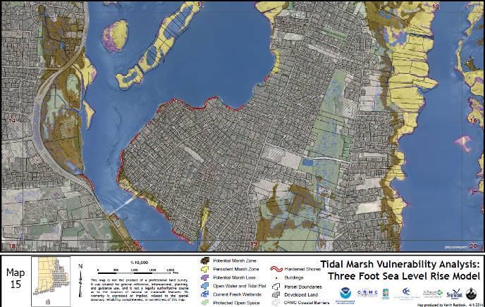
29 Critical Coastal Wetlands Graphic: Kevin Ruddock - TNC
 Consistent with median value from literature 105 Sub-Sites Historic SLR Trend to estimate subsidence/lift Direction offshore")
30 Model Parameters Accretion = 3.8 mm/yr Observations from NBNERR SET monitoring (K. Raposa) Consistent with median value from literature 105 Sub-Sites Historic SLR Trend to estimate subsidence/lift Direction offshore Erosion/sedimentation Storm Frequency Tidal Data Range Datum Adjustment RI SLAMM Project
31 Model Limitations Uncertainty in Sea Level Rise Projections Ground Conditions Some uplands may be more suitable than others Multiple stressors on salt marshes Freshwater wetlands may convert to open water Model Simplifications Accretion rates are variable Salinity dynamics are simplified Changing Coastline Storm events Barrier migration RI SLAMM Project

32 RI SLAMM Project Barrier Migration Issue

33 RI SLAMM Project Model Input: USGS 2011 LiDAR
34 Model Input: National Wetland Inventory 2010 RI SLAMM Project
35 RI SLAMM Project SLAMM Model Results
36 RI SLAMM Project SLAMM Model Results

37 RI SLAMM Project SLAMM Model Results
38 RI SLAMM Project SLAMM Model Results

39 RI SLAMM Project SLAMM Model Results

40 RI SLAMM Project SLAMM Model Results
41 RI SLAMM Project SLAMM Model Results
42 RI SLAMM Project SLAMM Model Results
43 RI SLAMM Project SLAMM Model Results
 450 1895 3189 Gain (Acres) 1057 1148 2151 Net Change (Acres) 607-747 -1038 RI SLAMM Project Photo: J.")
44 SLAMM Projected Statewide Salt Marsh Changes due to Sea Level Rise 50% of Current Salt Marshes SLR 1 Ft. 3 Ft. 5 Ft. Loss (Acres) Gain (Acres) Net Change (Acres) RI SLAMM Project Photo: J. Boyd

45 Town Coastal Wetland Loss (acres) Barrington Bristol 99.2 Charlestown Cranston 2.3 East Greenwich 0.4 East Providence 71.1 Jamestown Little Compton 96.5 Middletown 42.6 Narragansett New Shoreham 61.4 Newport 19.1 North Kingstown Pawtucket 0.1 Portsmouth Providence 3.1 South Kingstown Tiverton Warren Warwick Westerly TOTAL 3,258.8 Statistics for Coastal Wetland Loss with 5 feet Sea Level Rise
")

46 Freshwater (palustrine) wetland losses due to SLR RI SLAMM Project

47 Town 1ft SLR 3ft SLR 5ft SLR Barrington Bristol Charlestown Cranston East Providence Jamestown Little Compton Middletown Narragansett New Shoreham Newport North Kingstown Portsmouth South Kingstown Tiverton Warren Warwick Westerly Total Rhode Island Freshwater Wetland Losses due to SLR Narrow River Cattail Marsh Photo: J. Boyd 09/12/2014


48 RI SLAMM Project SLAMM maps on CRMC web page

49
 data and projections as planning and decision-making support tool in statewide coastal wetland monitoring,")
50 RI Executive Climate Change Coordinating Council Action Adopt Sea Level Affecting Marshes Model (SLAMM) data and projections as planning and decision-making support tool in statewide coastal wetland monitoring, protection and restoration strategy RI SLAMM Project

51 RI SLAMM Project Municipal SLAMM Training Workshops
 SAMP")

52 SLAMM Project is part of the Shoreline Change (Beach) SAMP RI SLAMM Project

53 Photo: R. Hancock A Very Big Thank You to NOAA for Funding the RI SLAMM Project with a Coastal and Ocean Climate Applications Grant!


54 Marsh Migration Modeling in Long Island Sound David Kozak CT DEEP-Office of Long Island Sound Program Kevin O Brien <kevin.obrien@ct.gov>, CT DEEP- Office of Long Island Sound Program Saltmarsh sparrows waits as Black grass invades forest understory, photos by Scott Warren and Paul Fusco
55 Long Island Sound America s Urban Sea

56 Long Island Sound
 Tidal")
57 Long Island Sound (LIS) Tidal Marshes-East
 Tidal")
58 Long Island Sound (LIS) Tidal Marshes-West
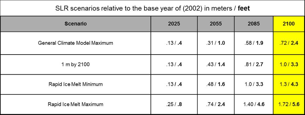
59 Modeling Approach SLR Affecting Marsh Migration (SLAMM) with uncertainty analysis * Study period: 4 time-steps SLR scenarios: 0.4 ft 5.6 ft (2025) (2100) Area of study: Area up to +5 meters (MSL) * Version 6.2, by Warren Pinnacle Consulting. Funding by EPA LIS Study, NOAA-OCRM. Cost: ~$ 109K (CT) + ~ $ 14K (NY s Westchester Cty.) = $123K
 ~575 sq mi of land area")
60 CT s SLAMM Study Area: + 5 meters (MSL) ~575 sq mi of land area (grey)
61 Sea-Level-Rise Scenarios
62 North Shore LIS SLAMM Results CT + Westchester, NY Modeled land cover change Land cover category Percent land cover change from 2010 to 2100 Acres in 2010 GCM Max 1m RIM Min RIM Max* Undeveloped Dry Land 195, Estuarine Open Water 119, Developed Dry Land 88, CT Acres in 2100 (1m) Westchester 2100 (1m) Acres No. Shore LIS 2100 (1m) Irreg.-Flooded Marsh 10, , ,325 Swamp 8, Inland Open Water 4, Estuarine Beach 2, Regularly-Flooded Marsh 2, , ,843 Transitional Salt Marsh 1, , ,413 Inland-Fresh Marsh Tidal-Fresh Marsh Tidal Swamp Riverine Tidal Flooded Developed Dry Land Tidal Flat Inland Shore Rocky Intertidal Ʃ Ʃ* (RIM Max.) 1. Includes 223 acres in Westchester 14, , ,581 14, , ,964
 0(2.7ft) (1.")
63 Sample Model Output Data- CT River Estuary Land Cover Classes: SLR: 0.13m 0.81m 0.43m SLR: (0.4ft) 0(2.7ft) (1.4ft) Time step


 Time Step")
64 Sample Model Output Data- CT River Estuary Uncertainty Range: Land Cover Classes: SLR: 0.43m 0.81m 0.13m (1.4ft) (2.7ft) (0.4ft) Time Step step


65 Rates of Saltmarsh Migration?? Can t ya migrate any faster?!
66 Modeling Limitations/Considerations LiDAR error/accuracy (what is acceptable std. dev. with actual bare earth elevation?) Limited IFM accretion (SET) data spanning entire elevation range NWI SLAMM wetland/land cover codes Not all model data sets (e.g. impervious cover) had the same 5m LiDAR resolution Variation in state wetland and SLAMM nomenclature /classification (e.g., tidal swamp) Insufficient SET data low in the tidal frame (RFMs)
67 Modeling Limitations/Considerations (cont.) Hydraulic connectivity may not be corrected through hydro-modifications Not a hydrodynamic model (accurate river/embayment predictions?) Incomplete accretion rates for RFMs using MEM Key MEM data deficiencies: Suspended sediment concentration Standing biomass density Organic matter decay rates Below ground biomass contribution parameters Sediment settling velocities Partition between organic and non-organic accretion components
68 LIS SLAMM II? What Would We Do Differently? Re-evaluate how SLAMM converts dry land to saltmarsh based on results of forthcoming research by Anisfeld, et al. Assemble more robust data for RFM accretion Re-examine MEM model assumptions and input values More detailed short term modeling ( ?) with field monitoring to test accuracy of predictions (or hind-casting?)

69 Don t Get Caught with Your Back to a Rising Tide Use SLAMM!
Modeling Sea-Level Rise in Coastal Wetlands: Understanding Potential Impacts and Their Implications for Management on Cape Cod
 Modeling Sea-Level Rise in Coastal Wetlands: Understanding Potential Impacts and Their Implications for Management on Cape Cod C a p e C o a s t a l C o n f e r e n c e H y a n n i s R e s o r t a n d
Sea Level Rise and the Scarborough Marsh Scarborough Land Trust Annual Meeting April 24, 2018
 Sea Level Rise and the Scarborough Marsh Scarborough Land Trust Annual Meeting April 24, 2018 Peter A. Slovinsky, Marine Geologist Maine Geological Survey Funded by: 50% 40% Figure modified from Griggs,
Sea-level Rise on Cape Cod: How Vulnerable Are We? Rob Thieler U.S. Geological Survey Woods Hole, MA
 Sea-level Rise on Cape Cod: How Vulnerable Are We? Rob Thieler U.S. Geological Survey Woods Hole, MA Outline Sea-level and coastal processes Past sea-level change Predictions for the future Coastal responses
The Use of Geographic Information Systems to Assess Change in Salt Marsh Ecosystems Under Rising Sea Level Scenarios.
 The Use of Geographic Information Systems to Assess Change in Salt Marsh Ecosystems Under Rising Sea Level Scenarios Robert Hancock The ecological challenges presented by global climate change are vast,
Presentation Outline. Project Overview. Sea Level Rise Assessment & Decision Tools. Community Engagement. Tina Whitman, Friends of the San Juans
 Healthy Beaches for People & Fish Sea Level Rise Adaptation Tools for San Juan County, WA Tina Whitman & Andrea MacLennan December 10, 2015 Presentation Outline Project Overview Tina Whitman, Friends of
Application of SLAMM to Coastal Connecticut. Final Report
 Application of SLAMM to Coastal Connecticut Final Report Prepared for: New England Interstate Water Pollution Control Commission Lowell, MA Emily Bird Project Manager Environmental Analyst Prepared by:
Protecting the Storm Damage Prevention and Flood Control Interests of Coastal Resource Areas
 Protecting the Storm Damage Prevention and Flood Control Interests of Coastal Resource Areas Presented by: Massachusetts Department of Environmental Protection & Massachusetts Office of Coastal Zone Management
Sea Level Rise Providing Nature A-Right-of Way
 Sea Level Rise Providing Nature A-Right-of Way Study Area Site 2: Skagit Bay Initial Condition 11.2 Inches by 2050 No Dikes 27.3 Inches by 2100 No Dikes The Problem Loss of coastal wetlands due to submergence
Application of the Sea-Level Affecting Marshes Model (SLAMM 6) to Texas Point NWR
 to Texas Point NWR") Application of the Sea-Level Affecting Marshes Model (SLAMM 6) to Texas Point NWR U. S. Fish and Wildlife Service National Wildlife Refuge System Division of Natural Resources and Conservation Planning
Application of the Sea-Level Affecting Marshes Model (SLAMM 6) to Texas Point NWR U. S. Fish and Wildlife Service National Wildlife Refuge System Division of Natural Resources and Conservation Planning
Application of the Sea-Level Affecting Marshes Model (SLAMM 6) to Back Bay NWR
 to Back Bay NWR") Application of the Sea-Level Affecting Marshes Model (SLAMM 6) to Back Bay NWR U. S. Fish and Wildlife Service National Wildlife Refuge System Division of Natural Resources and Conservation Planning Conservation
Application of the Sea-Level Affecting Marshes Model (SLAMM 6) to Back Bay NWR U. S. Fish and Wildlife Service National Wildlife Refuge System Division of Natural Resources and Conservation Planning Conservation
Application of the Sea-Level Affecting Marshes Model (SLAMM 6) to John Heinz NWR
 to John Heinz NWR") Application of the Sea-Level Affecting Marshes Model (SLAMM 6) to John Heinz NWR Prepared for: U. S. Fish and Wildlife Service National Wildlife Refuge System Division of Natural Resources and Conservation
Application of the Sea-Level Affecting Marshes Model (SLAMM 6) to John Heinz NWR Prepared for: U. S. Fish and Wildlife Service National Wildlife Refuge System Division of Natural Resources and Conservation
Adaptation to Sea Level Rise A Regional Approach
 Adaptation to Sea Level Rise A Regional Approach Project Partners: in Saco Bay, ME Peter Slovinsky, Marine Geologist Maine Geological Survey, Department of Conservation Project Funding from: Saco Bay Hazards
Appendix B. SLAMM Analysis of Kenai Peninsula and Anchorage, AK. Final Report
 Appendix B SLAMM Analysis of Kenai Peninsula and Anchorage, AK Final Report For: Jim Adams Director, Pacific Region National Wildlife Federation Anchorage, AK And: David Wigglesworth Coastal Program Manager
Sea Level Affecting Marshes Model (SLAMM) for Coastal Long Island Sound:
 for Coastal Long Island Sound:") 2100 DATA VIEWER MANUAL Sea Level Affecting Marshes Model (SLAMM) for Coastal Long Island Sound: Using a Web Mapping Application Data Viewer to Examine Predicted Land Cover Change for 2100 AUTHOR: KEVIN
2100 DATA VIEWER MANUAL Sea Level Affecting Marshes Model (SLAMM) for Coastal Long Island Sound: Using a Web Mapping Application Data Viewer to Examine Predicted Land Cover Change for 2100 AUTHOR: KEVIN
Evaluation of Regional SLAMM Results to Establish a Consistent Framework of Data and Models
 Evaluation of Regional SLAMM Results to Establish a Consistent Framework of Data and Models Prepared for the Gulf Coast Prairie Landscape Conservation Cooperative June, 2015 Minor Revisions, March 2016
Enhancing Coastal Resilience on Virginia s Eastern Shore: Application of the Sea-Level Affecting Marshes Model
 Enhancing Coastal Resilience on Virginia s Eastern Shore: Application of the Sea-Level Affecting Marshes Model Prepared for: The Nature Conservancy Charlottesville, VA Gwynn Crichton Sr. Project Scientist
COASTAL DATA APPLICATION
 2015 Coastal GeoTools Proactive By Design. Our Company Commitment COASTAL DATA APPLICATION Projecting Future Coastal Flood Risk for Massachusetts Bay Bin Wang, Tianyi Liu, Daniel Stapleton & Michael Mobile
Mapping of Future Coastal Hazards. for Southern California. January 7th, David Revell, Ph.D. E.
 Mapping of Future Coastal Hazards for Southern California January 7th, 2014 David Revell, Ph.D. drevell@esassoc.com E. Vandebroek, 2012 Outline Coastal erosion hazard zones Flood hazard zones: Coastal
Increasing Salt Marsh Resilience in the Face of SLR Investigating Thin Layer Deposition (Sediment Augmentation) as a Management Technique
 as a Management Technique") Increasing Salt Marsh Resilience in the Face of SLR Investigating Thin Layer Deposition (Sediment Augmentation) as a Management Technique Megan Tyrrell Waquoit Bay National Estuarine Research Reserve Coastal
Increasing Salt Marsh Resilience in the Face of SLR Investigating Thin Layer Deposition (Sediment Augmentation) as a Management Technique Megan Tyrrell Waquoit Bay National Estuarine Research Reserve Coastal
Section 145 Climate Change and Sea Level Rise
 Section 145 Climate Change and Sea Level Rise A. Definitions Rhode Island Coastal Resources Management Program 1. Climate is the long-term weather average observed within a geographic region, and climate
Application of the Sea-Level Affecting Marshes Model (SLAMM 6) to Pelican Island NWR
 to Pelican Island NWR") Application of the Sea-Level Affecting Marshes Model (SLAMM 6) to Pelican Island NWR U. S. Fish and Wildlife Service National Wildlife Refuge System Division of Natural Resources and Conservation Planning
Application of the Sea-Level Affecting Marshes Model (SLAMM 6) to Pelican Island NWR U. S. Fish and Wildlife Service National Wildlife Refuge System Division of Natural Resources and Conservation Planning
Planning for the Future of Humboldt Bay: Sea Level Rise, Sediment Management, Sand Spits and Salt Marshes. Joel Gerwein
 Planning for the Future of Humboldt Bay: Sea Level Rise, Sediment Management, Sand Spits and Salt Marshes Joel Gerwein Introduction to Humboldt Bay Setting Economy, community, and environment Sediment
9 th INTECOL Orlando, Florida June 7, 2012
 Restoration of the Everglades Saline Wetlands and Florida Bay: Responses Driven from Land and Sea David Rudnick 1, Colin Saunders 2, Carlos Coronado 2, Fred Sklar 2 Erik Stabenau 1, Vic Engel 1, Rene Price
Application of the Sea-Level Affecting Marshes Model (SLAMM 6) to Potomac River NWR Complex
 to Potomac River NWR Complex") Application of the Sea-Level Affecting Marshes Model (SLAMM 6) to Potomac River NWR Complex U. S. Fish and Wildlife Service National Wildlife Refuge System Division of Natural Resources and Conservation
Application of the Sea-Level Affecting Marshes Model (SLAMM 6) to Potomac River NWR Complex U. S. Fish and Wildlife Service National Wildlife Refuge System Division of Natural Resources and Conservation
Adapting to Rising Sea Level & Extreme Weather Events:
 Adapting to Rising Sea Level g & Extreme Weather Events: A Florida Perspective Randall W. Parkinson, Ph.D., P.G. President RWParkinson Consulting, Inc. Melbourne, Florida & Administrator Space Coast Climate
Developed in Consultation with Florida Educators
 Developed in Consultation with Florida Educators Table of Contents Next Generation Sunshine State Standards Correlation Chart... 7 Benchmarks Chapter 1 The Practice of Science...................... 11
Evaluation of Regional SLAMM Results to Establish a Consistent Framework of Data and Models
 Evaluation of Regional SLAMM Results to Establish a Consistent Framework of Data and Models Gulf Coast Prairie Land Conservation Cooperative December 15, 2014 PO Box 315, Waitsfield VT, 05673 (802)-496-3476
Tony Pratt, DNREC to The Center for the Inland Bays Scientific and Technical Advisory Committee. August 21, 2009
 Sea Level Rise in Delaware Presented by Tony Pratt, DNREC to The Center for the Inland Bays Scientific and Technical Advisory Committee August 21, 2009 Sea level has been fluctuating ever since there have
USGS efforts to model sea-level rise impact to tidal marshes along the California coast.
 USGS efforts to model sea-level rise impact to tidal marshes along the California coast. Karen Thorne 1 J.Y Takekawa 1, K. Buffington 1, K. Swanson 2, J. Drexler 2, D.Schoellhamer 2, M. Casazza 3, and
Application of the Sea-Level Affecting Marshes Model (SLAMM 6) to Kilauea Point NWR
 to Kilauea Point NWR") Application of the Sea-Level Affecting Marshes Model (SLAMM 6) to Kilauea Point NWR Prepared For U. S. Fish and Wildlife Service National Wildlife Refuge System Division of Natural Resources and Conservation
Application of the Sea-Level Affecting Marshes Model (SLAMM 6) to Kilauea Point NWR Prepared For U. S. Fish and Wildlife Service National Wildlife Refuge System Division of Natural Resources and Conservation
Preliminary Vulnerability Assessment of Coastal Flooding Threats - Taylor County, Florida
 Preliminary Vulnerability Assessment of Coastal Flooding Threats - Taylor County, Florida North Central Florida Regional Planning Council Northeast Florida Regional Council April 28, 2016 BACKGROUND This
Coastal Processes 101 & The Regs. Greg Berman (Woods Hole Sea Grant & Cape Cod Cooperative Extension)
") Coastal Processes 101 & The Regs Greg Berman (Woods Hole Sea Grant & Cape Cod Cooperative Extension) March 26, 2019 Coastal Processes 101 & The Regs Outline: ~15 min talk Coastal Processes What is Erosion?
Coastal Processes 101 & The Regs Greg Berman (Woods Hole Sea Grant & Cape Cod Cooperative Extension) March 26, 2019 Coastal Processes 101 & The Regs Outline: ~15 min talk Coastal Processes What is Erosion?
Town of Old Orchard Beach: A summary of sea level rise science, storm surge, and some highlighted results from SLAWG work efforts
 Town of Old Orchard Beach: A summary of sea level rise science, storm surge, and some highlighted results from SLAWG work efforts October 15, 2013 Peter A. Slovinsky, Marine Geologist Maine Geological
Application of the Sea-Level Affecting Marshes Model (SLAMM 6) to Crocodile Lake NWR
 to Crocodile Lake NWR") Application of the Sea-Level Affecting Marshes Model (SLAMM 6) to Crocodile Lake NWR U. S. Fish and Wildlife Service National Wildlife Refuge System Division of Natural Resources and Conservation Planning
Application of the Sea-Level Affecting Marshes Model (SLAMM 6) to Crocodile Lake NWR U. S. Fish and Wildlife Service National Wildlife Refuge System Division of Natural Resources and Conservation Planning
MEMORANDUM FOR SWG
 MEMORANDUM FOR SWG-2007-1623 Subject: Jurisdictional Determination (JD) for SWG-2007-1623 on Interdunal Wetlands Adjacent to Traditional Navigable Waters (TNWs) Summary The U.S. Environmental Protection
Article 11: Relating to Taxation Excise on Motor Vehicles and Trailers
 Article 11: Relating to Taxation Excise on Motor Vehicles and Trailers Article 11 uses four levers to decrease the motor vehicle excise tax each year from FY2018 through FY2023, fully eliminating the tax
Application of the Sea-Level Affecting Marshes Model (SLAMM 6) to Huleia NWR
 to Huleia NWR") Application of the Sea-Level Affecting Marshes Model (SLAMM 6) to Huleia NWR Prepared For U. S. Fish and Wildlife Service National Wildlife Refuge System Division of Natural Resources and Conservation
Application of the Sea-Level Affecting Marshes Model (SLAMM 6) to Huleia NWR Prepared For U. S. Fish and Wildlife Service National Wildlife Refuge System Division of Natural Resources and Conservation
Application of the Sea-Level Affecting Marshes Model (SLAMM 6) to Pearl Harbor NWR
 to Pearl Harbor NWR") Application of the Sea-Level Affecting Marshes Model (SLAMM 6) to Pearl Harbor NWR Prepared For: Dr. Brian Czech, Conservation Biologist U. S. Fish and Wildlife Service National Wildlife Refuge System
Application of the Sea-Level Affecting Marshes Model (SLAMM 6) to Pearl Harbor NWR Prepared For: Dr. Brian Czech, Conservation Biologist U. S. Fish and Wildlife Service National Wildlife Refuge System
Application of the Sea-Level Affecting Marshes Model (SLAMM 6) to Ten Thousand Islands NWR
 to Ten Thousand Islands NWR") Application of the Sea-Level Affecting Marshes Model (SLAMM 6) to Ten Thousand Islands NWR Prepared for Gulf of Mexico Alliance Habitat Conservation and Restoration Priority Issue Team Corpus Christi,
Application of the Sea-Level Affecting Marshes Model (SLAMM 6) to Ten Thousand Islands NWR Prepared for Gulf of Mexico Alliance Habitat Conservation and Restoration Priority Issue Team Corpus Christi,
4.2 Tidal Wetlands. Phragmites Australis
 4.2 Tidal Wetlands Few topics elicit such strong emotions in Guilford as the current state of salt marshes. These marshes, more broadly known as tidal wetlands, are undergoing a transformation as sea level
Appendix E: Cowardin Classification Coding System
 Appendix E: Cowardin Classification Coding System The following summarizes the Cowardin classification coding system and the letters and numbers used to define the USFWS NWI wetland types and subtypes:
Everglades National Park
 National Park Service U.S. Department of the Interior Climate Variability and the Coastal Physical Environment (Florida Bay) Presented by: Erik Stabenau - National Park Service Contributions from: Christina
Application of the Sea-Level Affecting Marshes Model (SLAMM 5.0) to Bon Secour National Wildlife Refuge
 to Bon Secour National Wildlife Refuge") Application of the Sea-Level Affecting Marshes Model (SLAMM 5.0) to Bon Secour National Wildlife Refuge Prepared For: Dr. Brian Czech, Conservation Biologist U. S. Fish and Wildlife Service National Wildlife
Application of the Sea-Level Affecting Marshes Model (SLAMM 5.0) to Bon Secour National Wildlife Refuge Prepared For: Dr. Brian Czech, Conservation Biologist U. S. Fish and Wildlife Service National Wildlife
Application of the Sea-Level Affecting Marshes Model (SLAMM 6) to Currituck NWR
 to Currituck NWR") Application of the Sea-Level Affecting Marshes Model (SLAMM 6) to Currituck NWR U. S. Fish and Wildlife Service National Wildlife Refuge System Division of Natural Resources and Conservation Planning Conservation
Application of the Sea-Level Affecting Marshes Model (SLAMM 6) to Currituck NWR U. S. Fish and Wildlife Service National Wildlife Refuge System Division of Natural Resources and Conservation Planning Conservation
Application of the Sea-Level Affecting Marshes Model (SLAMM 6) to Guam NWR
 to Guam NWR") Application of the Sea-Level Affecting Marshes Model (SLAMM 6) to Guam NWR Prepared For U. S. Fish and Wildlife Service National Wildlife Refuge System Division of Natural Resources and Conservation Planning
Application of the Sea-Level Affecting Marshes Model (SLAMM 6) to Guam NWR Prepared For U. S. Fish and Wildlife Service National Wildlife Refuge System Division of Natural Resources and Conservation Planning
Design of Levee Breaches in Sheltered Water for Flood Risk Reduction & Marsh Restoration ASFMP; June 5, 2014 Presented By:
 Design of Levee Breaches in Sheltered Water for Flood Risk Reduction & Marsh Restoration ASFMP; June 5, 2014 Presented By: Rohin Saleh Alameda County Flood Control District Matt Powers, P.E. GEI Consultants
Coastal Processes 101. Greg Berman (Woods Hole Sea Grant & Cape Cod Cooperative Extension)
") Coastal Processes 101 Greg Berman (Woods Hole Sea Grant & Cape Cod Cooperative Extension) January 23, 2019 Coastal Processes 101 Outline: ~30 min talk Coastal Processes What is Erosion? Value of the Ecosystem
Coastal Processes 101 Greg Berman (Woods Hole Sea Grant & Cape Cod Cooperative Extension) January 23, 2019 Coastal Processes 101 Outline: ~30 min talk Coastal Processes What is Erosion? Value of the Ecosystem
Application of the Sea-Level Affecting Marshes Model (SLAMM 6) to MS Sandhill Crane NWR
 to MS Sandhill Crane NWR") Application of the Sea-Level Affecting Marshes Model (SLAMM 6) to MS Sandhill Crane NWR Prepared for Gulf of Mexico Alliance Habitat Conservation and Restoration Priority Issue Team Corpus Christi, TX
Application of the Sea-Level Affecting Marshes Model (SLAMM 6) to MS Sandhill Crane NWR Prepared for Gulf of Mexico Alliance Habitat Conservation and Restoration Priority Issue Team Corpus Christi, TX
Application of the Sea-Level Affecting Marshes Model (SLAMM 5.1) to San Diego Bay NWR
 to San Diego Bay NWR") Application of the Sea-Level Affecting Marshes Model (SLAMM 5.1) to San Diego Bay NWR Prepared For: Dr. Brian Czech, Conservation Biologist U. S. Fish and Wildlife Service National Wildlife Refuge System
Application of the Sea-Level Affecting Marshes Model (SLAMM 5.1) to San Diego Bay NWR Prepared For: Dr. Brian Czech, Conservation Biologist U. S. Fish and Wildlife Service National Wildlife Refuge System
THIN-LAYER PLACEMENT OF DREDGE MATERIAL FOR MARSH NOURISHMENT, RESOTRATION, AND RESPONSE TO SEA LEVEL RISE
 THIN-LAYER PLACEMENT OF DREDGE MATERIAL FOR MARSH NOURISHMENT, RESOTRATION, AND RESPONSE TO SEA LEVEL RISE Case studies and lesson learned regarding thin-layer deposition projects in Delaware, New Jersey,
NOAA s OCM: Services, tools and collaboration opportunities & Puerto Rico s NE Marine Corridor as a case study
 NOAA s OCM: Services, tools and collaboration opportunities & Puerto Rico s NE Marine Corridor as a case study Dr. Antares Ramos Álvarez NOAA s Office of Coastal Management September 15 th, 2016 Conservation
Scenarios for the NI coast in the 21 st Century
 Scenarios for the NI coast in the 21 st Century Prof Julian Orford Geography, Archaeology & Palaeoecology Queen s University, Belfast Challenging perspective Living by the coast is good for your health!
Sea Level Rise in Miami-Dade County Florida Implications for Management of Coastal Wetlands and the Everglades
 Sea Level Rise in Miami-Dade County Florida Implications for Management of Coastal Wetlands and the Everglades Peter W. Harlem Dr. John F. Meeder Florida International University Southeast Environmental
Application of the Sea-Level Affecting Marshes Model (SLAMM 5.0) to Cabo Rojo and Laguna Cartagena National Wildlife Refuge
 to Cabo Rojo and Laguna Cartagena National Wildlife Refuge") Application of the Sea-Level Affecting Marshes Model (SLAMM 5.0) to Cabo Rojo and Laguna Cartagena National Wildlife Refuge Prepared For: Dr. Brian Czech, Conservation Biologist U. S. Fish and Wildlife
Application of the Sea-Level Affecting Marshes Model (SLAMM 5.0) to Cabo Rojo and Laguna Cartagena National Wildlife Refuge Prepared For: Dr. Brian Czech, Conservation Biologist U. S. Fish and Wildlife
Crystal Goodison & Alexis Thomas University of Florida GeoPlan Center
 Crystal Goodison & Alexis Thomas University of Florida GeoPlan Center A1A Fort Lauderdale, Hurricane Sandy, October 2012 Photo Credits: Susan Stocker, Sun Sentinel FAU s Research Report (completed Jan
Application of the Sea-Level Affecting Marshes Model (SLAMM 5.1) to Seatuck NWR
 to Seatuck NWR") Application of the Sea-Level Affecting Marshes Model (SLAMM 5.1) to Seatuck NWR Prepared For: Dr. Brian Czech, Conservation Biologist U. S. Fish and Wildlife Service National Wildlife Refuge System Division
Application of the Sea-Level Affecting Marshes Model (SLAMM 5.1) to Seatuck NWR Prepared For: Dr. Brian Czech, Conservation Biologist U. S. Fish and Wildlife Service National Wildlife Refuge System Division
COASTAL GEOLOGIC HAZARDS AND SEA-LEVEL RISE: CLIMATE CHANGE IN RHODE ISLAND
 COASTAL GEOLOGIC HAZARDS AND SEA-LEVEL RISE: CLIMATE CHANGE IN RHODE ISLAND Sakonnet Preservation Association Annual Meeting 9 July 2013 Jon C. Boothroyd 1,2 and Bryan A. Oakley 3 (1) Rhode Island Geological
Regional-scale understanding of the geologic character and sand resources of the Atlantic inner continental shelf, Maine to Virginia
 Regional-scale understanding of the geologic character and sand resources of the Atlantic inner continental shelf, Maine to Virginia Workshop on Dredging, Beach Nourishment and Bird Conservation Atlantic
Application of the Sea-Level Affecting Marshes Model (SLAMM 5.0) to Green Cay National Wildlife Refuge
 to Green Cay National Wildlife Refuge") Application of the Sea-Level Affecting Marshes Model (SLAMM 5.0) to Green Cay National Wildlife Refuge Prepared For: Dr. Brian Czech, Conservation Biologist U. S. Fish and Wildlife Service National Wildlife
Application of the Sea-Level Affecting Marshes Model (SLAMM 5.0) to Green Cay National Wildlife Refuge Prepared For: Dr. Brian Czech, Conservation Biologist U. S. Fish and Wildlife Service National Wildlife
Australian Coastal Councils Conference
 Australian Coastal Councils Conference 11 March 2015 Estimating Future Coastal Inundation and Erosion Hazards Dr Andrew McCowan Dr Christine Lauchlan-Arrowsmith Warwick Bishop Background Victorian Future
Sea-level Rise and Storm Effects on Coastal Systems under Changing Global Climate. Cape May, NJ 12 January 2009
 Sea-level Rise and Storm Effects on Coastal Systems under Changing Global Climate 2009 Delaware Estuary Science Summit Cape May, NJ 12 January 2009 S. Jeffress Williams Senior Coastal Marine Geologist
A process-based approach toward assessing the coastal impact of projected sea level rise and severe storms
 A process-based approach toward assessing the coastal impact of projected sea level rise and severe storms Patrick Barnard 1, Cheryl Hapke 2, Li Erikson 1, Amy Foxgrover 1, and Maarten van Ormondt 3 1
Assessing the Vulnerability of Alaska s Coastal Habitats to Accelerating Sea-level Rise Using the SLAMM Model: A Case Study for Cook Inlet
 Assessing the Vulnerability of Alaska s Coastal Habitats to Accelerating Sea-level Rise Using the SLAMM Model: A Case Study for Cook Inlet Photo by: David Wigglesworth, USFWS Region 7 Coastal Program Prepared
Current and Future Technology Applications for Coastal Zone Management. Bruce K. Carlisle, Acting Director Office of Coastal Zone Management
 Current and Future Technology Applications for Coastal Zone Management Bruce K. Carlisle, Acting Director Office of Coastal Zone Management The Massachusetts Coastal Zone Management Program Approved in
Preliminary Data Release for the Humboldt Bay Sea Level Rise Vulnerability Assessment: Humboldt Bay Sea Level Rise Inundation Mapping
 Preliminary Data Release for the Humboldt Bay Sea Level Rise Vulnerability Assessment: Humboldt Bay Sea Level Rise Inundation Mapping Prepared by: Jeff Anderson, Northern Hydrology & Engineering (jeff@northernhydrology.com)
Modeling the Fate of New Jersey s Salt Marshes Under Future Sea Level Rise
 Modeling the Fate of New Jersey s Salt Marshes Under Future Sea Level Rise Richard Lathrop and John Bognar Contact: lathrop@crssa.rutgers.edu Center for Remote Sensing & Spatial Analysis, Rutgers University
From Vulnerability to Resilience And the Tools to Get There. Out of Harm s Way Partnership for the Delaware Estuary August 1, 2012
 From Vulnerability to Resilience And the Tools to Get There Out of Harm s Way Partnership for the Delaware Estuary August 1, 2012 Today s Presentation Tour of New Jersey Challenges Definitions so we re
Analysis of Tides and Storm Surge from Observational Records in the Delaware Inland Bays
 Analysis of Tides and Storm Surge from Observational Records in the Delaware Inland Bays John Callahan Delaware Geological Survey Coastal GeoTools Conference March 30 April 2, 2015 Charleston, SC Outline
Baseline Estuarine-Upland Transition Zone
 Baseline Estuarine-Upland Transition Zone in SF, San Pablo and Suisun Bays 10/5/18 Prepared for San Francisco Bay Joint Venture (SFBJV) Prepared by Brian Fulfrost, Principal bfaconsult@gmail.com with additional
Carbon Sequestration Potential from Coastal Wetlands Restoration Sites
 Carbon Sequestration Potential from Coastal Wetlands Restoration Sites Insert then choose Picture select your picture. Right click your picture and Send to back. Paul Krause, Alyssa Beach Emily Cooper,
Randall W. Parkinson, Ph.D., P.G. Institute of Water and Environment Florida International University
 An Update on Adaptation Action Activities Undertaken Since Completion of the City of Satellite Beach (FL) Vulnerability Assessment to Rising Seas (2010) Randall W. Parkinson, Ph.D., P.G. Institute of Water
Opportunities to Improve Ecological Functions of Floodplains and Reduce Flood Risk along Major Rivers in the Puget Sound Basin
 Opportunities to Improve Ecological Functions of Floodplains and Reduce Flood Risk along Major Rivers in the Puget Sound Basin Christopher Konrad, US Geological Survey Tim Beechie, NOAA Fisheries Managing
Shoreline Mapping & Erosion Patterns. Julia Knisel Julia Knisel Coastal Shoreline & Floodplain Manager
 Shoreline Mapping & Erosion Patterns Along the Massachusetts Coast Julia Knisel Julia Knisel Coastal Shoreline & Floodplain Manager CZM Shoreline Change Project Timeline 1989: produced coast wide maps
Summary Description Municipality of Anchorage. Anchorage Coastal Resource Atlas Project
 Summary Description Municipality of Anchorage Anchorage Coastal Resource Atlas Project By: Thede Tobish, MOA Planner; and Charlie Barnwell, MOA GIS Manager Introduction Local governments often struggle
Town of Cape Elizabeth: A summary of some of the latest sea level rise science and storm surge data to help guide municipal ordinance changes
 Town of Cape Elizabeth: A summary of some of the latest sea level rise science and storm surge data to help guide municipal ordinance changes May 29, 2014 Peter A. Slovinsky, Marine Geologist Maine Geological
Application of the Sea-Level Affecting Marshes Model (SLAMM 6) to Bandon Marsh NWR
 to Bandon Marsh NWR") Application of the Sea-Level Affecting Marshes Model (SLAMM 6) to Bandon Marsh NWR Prepared For: Dr. Brian Czech, Conservation Biologist U. S. Fish and Wildlife Service National Wildlife Refuge System
Application of the Sea-Level Affecting Marshes Model (SLAMM 6) to Bandon Marsh NWR Prepared For: Dr. Brian Czech, Conservation Biologist U. S. Fish and Wildlife Service National Wildlife Refuge System
Analysis of Shoreline Change in Connecticut 100 Years of Erosion and Accretion
 Analysis of Shoreline Change in Connecticut 100 Years of Erosion and Accretion Joel Stocker UConn Extension Kevin O Brien CT DEEP OLISP Juliana Barrett Connecticut Sea Grant Bruce Hyde UConn Extension
THE DEVELOPMENT OF A SALT MARSH MIGRATION TOOL AND ITS APPLICATION IN LONG ISLAND SOUND INTRODUCTION
 THE DEVELOPMENT OF A SALT MARSH MIGRATION TOOL AND ITS APPLICATION IN LONG ISLAND SOUND Mark Hoover, Research Specialist Daniel Civco, Professor Department of Natural Resources and the Environment Center
Taunton River Salt Marsh Assessment Results from 2014 season
 Taunton River Salt Marsh Assessment Results from 2014 season December, 2014 During the late summer and fall of 2014, Save The Bay evaluated salt marshes in Assonet Bay, Freetown and Broad Cove in Dighton
Assessing the local impacts of sea level rise
 Assessing the local impacts of sea level rise Ian Miller, Coastal Hazards Specialist Washington Sea Grant MRC Conference Port Townsend, WA 5 December 2014 With contributions from: Eric Grossman, USGS;
Positioning the Pacific: NOAA s Geospatial Activities. Juliana Blackwell, Director NOAA s National Geodetic Survey March 6, 2012
 Positioning the Pacific: NOAA s Geospatial Activities Juliana Blackwell, Director NOAA s National Geodetic Survey March 6, 2012 A Common Problem of the Early 19 th Century 1807 President Thomas Jefferson
The rate and fate of coastal carbon burial
 The rate and fate of coastal carbon burial Matthew L. Kirwan, Virginia Institute of Marine Science Main Points Marsh size Marsh accretion 1. SLR drives wetland carbon burial in vertical and lateral dimensions
Application of the Sea-Level Affecting Marshes Model (SLAMM 6) to Don Edwards NWR
 to Don Edwards NWR") Application of the Sea-Level Affecting Marshes Model (SLAMM 6) to Don Edwards NWR Prepared For: Dr. Brian Czech, Conservation Biologist U. S. Fish and Wildlife Service National Wildlife Refuge System Division
Application of the Sea-Level Affecting Marshes Model (SLAMM 6) to Don Edwards NWR Prepared For: Dr. Brian Czech, Conservation Biologist U. S. Fish and Wildlife Service National Wildlife Refuge System Division
Heather Schlosser Army Corps of Engineers Coastal Studies Group August 28, 2008
 Got sand? Regional Sediment Management in Orange County Heather Schlosser Army Corps of Engineers Coastal Studies Group August 28, 2008 Regional Sediment Management Regional sediment management recognizes
The Refugia Concept: Using Watershed Analysis to Prioritize Salmonid Habitat for Conservation and Restoration
 The Refugia Concept: Using Watershed Analysis to Prioritize Salmonid Habitat for Conservation and Restoration Christopher May Battelle & UW Cumulative Impacts of Urbanization Landscape Alterations Loss
CLIMATE READY BOSTON. Climate Projections Consensus ADAPTED FROM THE BOSTON RESEARCH ADVISORY GROUP REPORT MAY 2016
 CLIMATE READY BOSTON Sasaki Steering Committee Meeting, March 28 nd, 2016 Climate Projections Consensus ADAPTED FROM THE BOSTON RESEARCH ADVISORY GROUP REPORT MAY 2016 WHAT S IN STORE FOR BOSTON S CLIMATE?
exposed has to the this soil lowest water salinity. However in the fall, following a lot of Underground
 How deep it collects from Background information for Data Analysis for Mass Audubon s Salt Marsh Science Project* We are measuring salinity at different depths to see what conditions Phragmites, and other
Promoting Resilience to Changing Weather
 Promoting Resilience to Changing Weather Harpswell Neck Harpswell Sound Orr s Island Basin Cove Pott s Point Harpswell Conservation Commission March 30, 2017 What Does This Mean for Harpswell? Topography
Sea Level Rise Study Summary Town of South Bethany
 Sea Level Rise Study Summary Town of South Bethany This presentation was prepared by Anchor QEA for the Town of South Bethany using Federal Funds under award NA14 NOS 419 0123 from the Delaware Coastal
Tools to Assess Flood Risk of Commercial Property Investment
 Tools to Assess Flood Risk of Commercial Property Investment NSERC Workshop March 1, 2016 Kate Collins, Tim Webster, Nathan Crowell AGRG, NSCC, Middleton, NS https://eatsleepride.com/ http://users.eastlink.ca/~tbulley/
SLAMM 6.3 Technical Documentation. Sea Level Affecting Marshes Model, Version 6.3 beta
 SLAMM 6.3 Technical Documentation Sea Level Affecting Marshes Model, Version 6.3 beta DRAFT December 11, 2012 SLAMM 6.3 Technical Documentation Sea Level Affecting Marshes Model, Version 6.3 beta Acknowledgements...
Virginia Shoreline Mapping Tools
 Virginia Shoreline Mapping Tools December 15, 2017 Karen Duhring Center for Coastal Resources Management Virginia Institute of Marine Science College of William & Mary Virginia Shoreline Mapping Tools
Geol 117 Lecture 18 Beaches & Coastlines. I. Types of Coastlines A. Definition:
 I. Types of Coastlines A. Definition: 1. Shore = narrow zone where ocean meets land (e.g. beach) 2. Coast is a broad area where both ocean and land processes act a. Includes onshore marshes, dunes, sea
SAGE. Systems Approach to Geomorphic Engineering. Barnegat Bay Pilot. Heather Jensen Philadelphia District. US Army Corps of Engineers BUILDING STRONG
 SAGE Systems Approach to Geomorphic Engineering Barnegat Bay Pilot Heather Jensen Philadelphia District US Army Corps of Engineers SAGE Nationwide program with a Regional Approach Innovative approach to
Coastal Barrier Island Network (CBIN): Management strategies for the future
: Management strategies for the future") Coastal Barrier Island Network (CBIN): Management strategies for the future Heather Joesting*, Amy Williams**, Rusty Feagin**, and William K. Smith* *Department of Biology, Wake Forest University, Winston
Coastal Barrier Island Network (CBIN): Management strategies for the future Heather Joesting*, Amy Williams**, Rusty Feagin**, and William K. Smith* *Department of Biology, Wake Forest University, Winston
ICAN Great Lakes 2010 Workshop
 ICAN Great Lakes 2010 Workshop Chris Cortina Maryland s Chesapeake & Coastal Program MD Department of Natural Resources Maryland s Coastal Atlas: What is it? The Coastal Atlas is an online mapping and
Sea Level Rise in Connecticut A Risk-Informed Approach
 GZA GeoEnvironmental, Inc. CAFM Conference October 25, 2017 Proactive By Design. Our Company Commitment Proactive By Design. Our Company Commitment Sea Level Rise in Connecticut A Risk-Informed Approach
Nutrient and Sediment Cycling and Retention in Urban Floodplain Wetlands
 Nutrient and Sediment Cycling and Retention in Urban Floodplain Wetlands Greg Noe, Cliff Hupp, Nancy Rybicki, Ed Schenk, and Jackie Batson National Research Program, Reston VA U.S. Department of the Interior
Everglades National Park
 National Park Service U.S. Department of the Interior Water Budget, Climate Variability, and Predicting Salinity for Eastern Florida Bay Erik Stabenau and Kevin Kotun National Park Service Erik_Stabenau@nps.gov
DELINEATION OF COASTAL SET-BACK LINES AND OVERLAY ZONES IN WEST COAST DISTRICT
 DELINEATION OF COASTAL SET-BACK LINES AND OVERLAY ZONES IN WEST COAST DISTRICT I. Bekko C. George IAIA Conference August 2014 Content Background and Context Process followed for West Coast District Set-back