Tools to Assess Flood Risk of Commercial Property Investment
|
|
|
- Christian James
- 5 years ago
- Views:
Transcription


1 Tools to Assess Flood Risk of Commercial Property Investment NSERC Workshop March 1, 2016 Kate Collins, Tim Webster, Nathan Crowell AGRG, NSCC, Middleton, NS

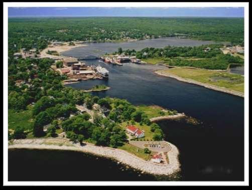

2 Liverpool, NS Mersey River

3 FLOODED AGAIN The Liverpool waterfront flooded again on Dec The Advance Home Hardware

4 February 9, 2013 Storm surge floods coastal Nova Scotia -Chronicle Herald

5 February 9, 2013 wharves underwater, roads impassable -Chronicle Herald


6 Photo from pre-infill of the harbour which was done between Parsons Investments Small NS company with commercial and residential real estate properties across the province and in Liverpool The company is looking to develop tools to investigate flood mitigation options, and provide a greater understanding of flooding potential for future property development and coastal investments. AGRG awarded an NSERC Engage Project to assist Parsons Investments in determining the susceptibility of its assets in Liverpool to flooding as well as Liverpool's downtown area, and propose adaptation strategies Map of Liverpool prior to harbour infilling.

7 Hydro Generating Plants on Mersey River Mersey River Liverpool

8 GIS Model Using Topographic Lidar Study area focused on downtown to capture Parsons Buildings, model known high water levels Lidar Survey: October 23, 2015

9 Colour Shaded Relief Model
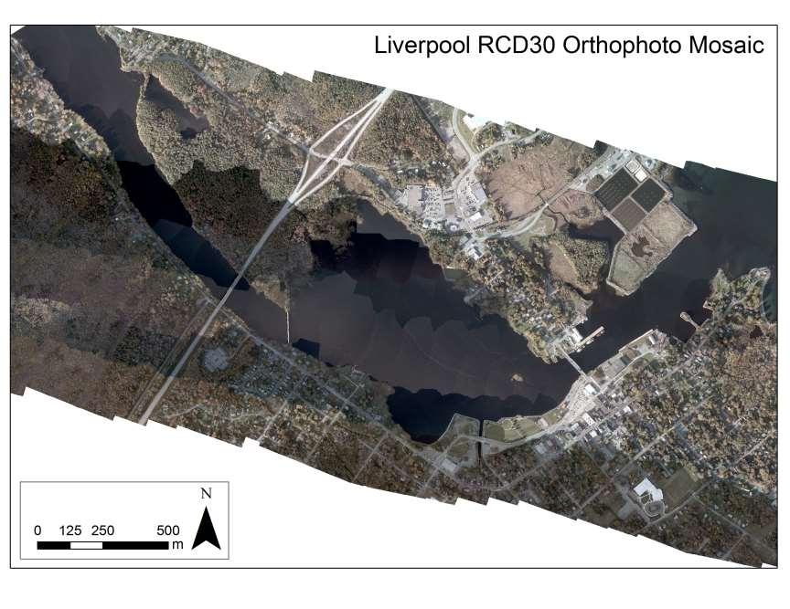
10 Orthophoto Mosaic

11 Hydrologically Corrected DEM: culverts added, bridges removed


12 Ground Truth RTK GPS of roads (for lidar validation) High water marks (for model validation)


13 Pressure Sensor Deployment September to December 2015 tidal range ~2 m near high tide during lidar survey
14 GIS Model Validation: High Tide

15 Feb 9 7: m Storm Surge recorded at Halifax Tide Gauge

16 m Feb 9 7: m Storm Surge recorded at Halifax Tide Gauge; 1.98 m GPS point at Home Hardware ground
 http://www.gov.pe.ca/photos/original/ccscenarios.")

17 Future Flooding Scenario 1 Max Tide (HHWLT) 1.26 Water Level (m CGVD28) Liverpool CD to CGVD28 = m Scenario 2 Scenario 3 Juan at Max High Tide, present day Juan at Max High Tide in future with SLR = = 4.43
18 Scenario 2: HHWLT + Juan 2.89 m CGVD28


19 Scenario 2: HHWLT + Juan + SLR 4.43 m CGVD28 Model was validated by Feb 2013 storm Used to predict future storm surges Next steps: to modify Hydro DEM to include coastal protection and present how downtown is affected then

20 GIS Flood Animation Max Flood 4.4 m


")
21 Hydrodynamic Model Mike 2D by DHI Rectangular 9 m resolution grid interpolated from various bathymetry sources CHS single beam echo sounder cross sections lidar Constant flow for river boundary condition (estimated from flow measurements) Ocean boundary is Feb 2013 storm surge
22 Results AVI

23 Resultsdowntown
 Therefore the Mersey is regulated more, and doesn t see a lot of overland or fluvial flooding Also, Bridgewater is much farther inland than Liverpool,")
24 Comparison with LaHave Estuary Similar system to LaHave which we have studied extensively- similar watershed size, etc But river systems behave differently and respond differently to floods because the Mersey has several NSPI dams along it (7) Therefore the Mersey is regulated more, and doesn t see a lot of overland or fluvial flooding Also, Bridgewater is much farther inland than Liverpool, and doesn t see nearly as much storm surge


25 LaHave Results 100 yr discharge + 3 m surge Example of interaction between discharge and tidesurge
26 Conclusions and Future work HD model grid modification bathymetry fine-tuning validation using pressure sensor For both sets of results GIS intersection of roads, infrastructure and flood layers to quantify what s at risk Mitigation and Adaptation Modify DEM with elevated berm or parking lot


27 Acknowledgements
Submitted to. Prepared by
 Prepared by Tim Webster, PhD Candace MacDonald Applied Geomatics Research Group NSCC, Middleton Tel. 902 825 5475 email: tim.webster@nscc.ca Submitted to Harold MacNeil Engineering Manager Halifax Water
Candace MacDonald, BSc, A.Dip. March 31, 2016
 Prepared by Submitted to Candace MacDonald, BSc, A.Dip Tim Webster, PhD. Applied Geomatics Research Group NSCC, Middleton, NS Tel. 902-825-5475 email: candace.macdonald@nscc.ca tim.webster@nscc.ca March
Integrated River and Coastal Hydrodynamic Flood Risk Mapping of the LaHave River Estuary and Town of Bridgewater
 Integrated River and Coastal Hydrodynamic Flood Risk Mapping of the LaHave River Estuary and Town of Bridgewater Tim Webster, PhD Kevin McGuigan, Kate Collins, Candace MacDonald Applied Geomatics Research
Adapting to Sea Level Rise: Halifax Harbour,, Nova Scotia
 Adapting to Sea Level Rise: Halifax Harbour,, Nova Scotia Roger Wells Regional and Community Planning Halifax Regional Municipality Contributors: Donald Forbes, NRCAN Chris Hopkinson, NSCC John Charles,
Bathymetric lidar to support pre-engineering analysis for marine liquefied natural gas transport infrastructure
 Bathymetric lidar to support pre-engineering analysis for marine liquefied natural gas transport infrastructure Candace MacDonald, Dr. Tim Webster Kate Collins, Nathan Crowell, Kevin McGuigan NSCC Applied
Tool 2.1.4: Inundation modelling of present day and future floods
 Impacts of Climate Change on Urban Infrastructure & the Built Environment A Toolbox Tool 2.1.4: Inundation modelling of present day and future floods Authors M. Duncan 1 and G. Smart 1 Affiliation 1 NIWA,
Sea Level Rise and Hurricane Florence storm surge research methodology
 Sea Level Rise and Hurricane Florence storm surge research methodology Hurricane Florence storm surge analysis was conducted using a variety of input sources. In order to determine the maximum storm surge
USING MIKE TO MODEL COASTAL CATASTROPHE RISK
 USING MIKE TO MODEL COASTAL CATASTROPHE RISK Nicola Howe, Christopher Thomas, Joss Matthewman, John Maskell* 1 SUMMARY About RMS Who are we and what do we do? How do we use MIKE in our workflow? Case study:
Survey Grade GPS Storm Surge High Water Mapping
 Atlantic Climate Adaptation Solutions Association Solutions d'adaptation aux changements climatiques pour l'atlantique Survey Grade GPS Storm Surge High Water Mapping November 2011 Applied Geomatics Research
Crystal Goodison & Alexis Thomas University of Florida GeoPlan Center
 Crystal Goodison & Alexis Thomas University of Florida GeoPlan Center A1A Fort Lauderdale, Hurricane Sandy, October 2012 Photo Credits: Susan Stocker, Sun Sentinel FAU s Research Report (completed Jan
Savannah Harbor Expansion Project
 Savannah Harbor Expansion Project Evaluation of Hurricane Surge Impacts with Proposed Mitigation Plan December 2007 Introduction This report summarizes the results of hurricane surge impacts with implementation
Dewberry Support to Federal, State, and Local Governments with Hurricane Evacuation Studies
 Dewberry Support to Federal, State, and Local Governments with Hurricane Evacuation Studies FEMA R2 and USACE Jacksonville Study Coordinators Presenting the Puerto Rico GeoPDF in San Juan About Dewberry
Atlantic Climate Adaptation Solutions Association Solutions d adaptation aux changements climatiques pour l Atlantique
 Atlantic Climate Adaptation Solutions Association Solutions d adaptation aux changements climatiques pour l Atlantique An Evaluation of Flood Risk to Infrastructure Across the Chignecto Isthmus by Tim
Preliminary Data Release for the Humboldt Bay Sea Level Rise Vulnerability Assessment: Humboldt Bay Sea Level Rise Inundation Mapping
 Preliminary Data Release for the Humboldt Bay Sea Level Rise Vulnerability Assessment: Humboldt Bay Sea Level Rise Inundation Mapping Prepared by: Jeff Anderson, Northern Hydrology & Engineering (jeff@northernhydrology.com)
European Geosciences Union General Assembly Vienna, Austria 27 April - 02 May 2014
 European Geosciences Union General Assembly Vienna, Austria 27 April - 02 May 2014 Projecting the Current & Future Impact of Storm Surges on Coastal Flood Extent at Pigeon Point, South-West Tobago, through
AHEAD OF THE STORM: Extreme Weather Resilience in the City of Toronto
 AHEAD OF THE STORM: Extreme Weather Resilience in the City of Toronto David MacLeod Toronto Environment and Energy Office Environmental Applied Science and Management Symposium 2013 March 21, 2013 Ahead
Coastal Inundation Forecasting and Community Response in Bangladesh
 WMO Coastal Inundation Forecasting and Community Response in Bangladesh Bapon (SHM) Fakhruddin Nadao Kohno 12 November 2015 System Design for Coastal Inundation Forecasting CIFDP-PSG-5, 14-16 May 2014,
Data Dictionary Hudson River Features: Estuary shoreline Flood scenario Emergency Services: Police stations Fire stations EMS
 Data Dictionary Hudson River Features: Estuary shoreline This data layer represents the border of the Hudson River in our study area. New York State Department of Environmental Conservation. 2009. Hudson
Manitoba s Elevation (LiDAR) & Imagery Datasets. Acquisition Plans & Opportunities for Collaboration
 & Imagery Datasets. Acquisition Plans & Opportunities for Collaboration") Manitoba s Elevation (LiDAR) & Imagery Datasets Acquisition Plans & Opportunities for Collaboration Manitoba Planning Conference May 2017 Presentation Outline Manitoba s Elevation (LiDAR) and Imagery Datasets
Manitoba s Elevation (LiDAR) & Imagery Datasets Acquisition Plans & Opportunities for Collaboration Manitoba Planning Conference May 2017 Presentation Outline Manitoba s Elevation (LiDAR) and Imagery Datasets
Atlantic Climate Adaptation Solutions Association Solutions d adaptation aux changements climatiques pour l Atlantique
 Atlantic Climate Adaptation Solutions Association Solutions d adaptation aux changements climatiques pour l Atlantique An Evaluation of Flood Risk to Infrastructure Across the Chignecto Isthmus by Tim
TOWNSVILLE STORM SURGE HYPOTHETICAL: TECHNICAL SPECIFICATIONS
 TOWNSVILLE STORM SURGE HYPOTHETICAL: TECHNICAL SPECIFICATIONS Stuart Mead, Mahesh Prakash and Fletcher Woolard CSIRO Mathematics, Informatics and Statistics, Private Bag 33, Clayton South, VIC 3168, Australia
Modelling coastal flood risk in the data poor Bay of Bengal region
 Modelling coastal flood risk in the data poor Bay of Bengal region Matt Lewis*, Kevin Horsburgh (NOC), Paul Bates (Bristol) *m.j.lewis@bangor.ac.uk Funded by the EPSRC Flood Risk Management Research Consortium
DFO Tanker Safety 2017 Project Report
 DFO Tanker Safety 2017 Project Report Prepared by Applied Geomatics Research Group NSCC, Middleton Tel. 902 825 5475 email: tim.webster@nscc.ca Submitted to: Scott Coffen-Smout Oceans and Coastal Management
Coupling of Wave and Hydrodynamic Models for Predicting Coastal Inundation: A case study in Jakarta and Semarang
 Coupling of Wave and Hydrodynamic Models for Predicting Coastal Inundation: A case study in Jakarta and Semarang http://peta-maritim.bmkg.go.id/cifdp/maps Nelly Florida Riama,Andri Ramdhani, Andi Eka Sakya,,
08/01/2012. LiDAR. LiDAR Benefits. LiDAR-BASED DELINEATION OF WETLAND BORDERS. CCFFR-2012 Society for Canadian Limnologists:
 LiDAR CCFFR-2012 Society for Canadian Limnologists: Science for Wetland Policy and Management LiDAR-BASED DELINEATION OF WETLAND BORDERS Distance from laser to ground and back again: Determined as laser-pulse
Papua New Guinea LiDAR Factsheet. Pacific-Australia Climate Change Science and Adaptation Planning. Vanimo. Bismark Sea. Wewak
 Pacific-Australia Climate Change Science and Adaptation Planning INDONESIA Vanimo Ninigo Group Wewak Madang Mount Hagen Kundiawa Goroka Mendi Daru AUSTRALIA Kerema Gulf of Papua Admiralty Islands Mussau
Mapping of Aquaculture Bays in the Gulf Region for Marine Spatial Planning
 Mapping of Aquaculture Bays in the Gulf Region for Marine Spatial Planning Prepared by Submitted to Applied Geomatics Research Group NSCC, Middleton Tel. 902 825 5475 email: tim.webster@nscc.ca Monique
COASTAL DATA APPLICATION
 2015 Coastal GeoTools Proactive By Design. Our Company Commitment COASTAL DATA APPLICATION Projecting Future Coastal Flood Risk for Massachusetts Bay Bin Wang, Tianyi Liu, Daniel Stapleton & Michael Mobile
Michael Cranston, Claire Harley, Lauren McLean, Amy Tavendale, Darroch Kaye, and Lisa Naysmith (Flood Forecasting and Warning section)
") Firths of Forth and Tay Flood Warning System and the Storms of 2012-2014 Keming Hu Acknowledgements Michael Cranston, Claire Harley, Lauren McLean, Amy Tavendale, Darroch Kaye, and Lisa Naysmith (Flood
Firths of Forth and Tay Flood Warning System and the Storms of 2012-2014 Keming Hu Acknowledgements Michael Cranston, Claire Harley, Lauren McLean, Amy Tavendale, Darroch Kaye, and Lisa Naysmith (Flood
New Jersey Department of Transportation Extreme Weather Asset Management Pilot Study
 New Jersey Department of Transportation Extreme Weather Asset Management Pilot Study Overview Prepared for: June 26, 2018 Introduction Overview of Pilot Study New Jersey s Climate New Jersey s Transportation
The XYZs of Digital Elevation Technologies
 May 2003 The XYZs of Digital Elevation Technologies Contains a reprint of the artcle entitled: Mapping Storm Surge Flood Risk Using a LIDAR-Derived DEM by Tim Webster, Steve Dickie, Charles O Reilly, Don
Turn and Face the Strange: Economic Impacts of Climate Change Sea Level Rise and Coastal Flooding E2Tech Forum June 21, 2018
 Turn and Face the Strange: Economic Impacts of Climate Change Sea Level Rise and Coastal Flooding E2Tech Forum June 21, 2018 Peter A. Slovinsky, Marine Geologist Maine Geological Survey Image from Chebeague.org
Benchmarking of Hydrodynamic Models for Development of a Coupled Storm Surge Hazard-Infrastructure Modeling Method to improve Inundation Forecasting
 Benchmarking of Hydrodynamic Models for Development of a Coupled Storm Surge Hazard-Infrastructure Modeling Method to improve Inundation Forecasting Abstract Fragility-based models currently used in coastal
multibeam bathymetric data is often based on the local depth datum, which is the local lowest normal low sea level, see the Figure 1. Multibeam Bathym
 3D DYNAMIC TERRAIN VISUALIZATION OF ISLAND AREAS AI Bo a, *, TANG Xinming b, SHI Shaoyu c, WANG Hongyan d, YANG Fanlin e a Geomatics College, Shandong University of Science and Technology, Qingdao, China
Randall W. Parkinson, Ph.D., P.G. Institute of Water and Environment Florida International University
 An Update on Adaptation Action Activities Undertaken Since Completion of the City of Satellite Beach (FL) Vulnerability Assessment to Rising Seas (2010) Randall W. Parkinson, Ph.D., P.G. Institute of Water
Moving Freshwater to the Ocean: Hydrology-Ocean Model Coupling
 Moving Freshwater to the Ocean: Hydrology-Ocean Model Coupling Cheryl Ann Blain 1, Tim Campbell 1, Song Yang 2, Aubrey Dugger 3, Paul Martin 1, Tommy Jenson 1 Naval Research Laboratory 1 Oceanography Division,
Preliminary Vulnerability Assessment of Coastal Flooding Threats - Taylor County, Florida
 Preliminary Vulnerability Assessment of Coastal Flooding Threats - Taylor County, Florida North Central Florida Regional Planning Council Northeast Florida Regional Council April 28, 2016 BACKGROUND This
Assessing Storm Tide Hazard for the North-West Coast of Australia using an Integrated High-Resolution Model System
 Assessing Storm Tide Hazard for the North-West Coast of Australia using an Integrated High-Resolution Model System J. Churchill, D. Taylor, J. Burston, J. Dent September 14, 2017, Presenter Jim Churchill
Coastal Sea Level Rise Risk Assessment
 Attachment 1 to Appendix A Capital Regional District Coastal Sea Level Rise Risk Assessment Prepared by: AECOM 200 415 Gorge Road East Victoria, BC, Canada V8T 2W1 www.aecom.com January 2015 Statement
Term Knowledge Using and applying Grade Criteria Autumn 1 Assessment window October Natural hazards pose major risks to people and property.
 Assessment Schedule Year 9 2015/6 Term Knowledge Using and applying Grade Criteria Autumn 1 Assessment window October 2015 3.1.1.2 Tectonic Natural hazards pose major risks to people and property. Definition
COMPOUND FLOODING: EXAMPLES,
 1 COMPOUND FLOODING: EXAMPLES, METHODS, AND CHALLENGES Thomas Wahl Civil, Environmental and Construction Engineering & National Center for Integrated Coastal Research University of Central Florida Definition(s)
An overview of the applications for early warning and mapping of the flood events in New Brunswick
 Flood Recovery, Innovation and Reponse IV 239 An overview of the applications for early warning and mapping of the flood events in New Brunswick D. Mioc 1, E. McGillivray 2, F. Anton 1, M. Mezouaghi 2,
The use of MIKE21 to study the. barrier beach system of Inner Dingle Bay, Co. Kerry, Ireland. Dr. Michael O Shea Malachy Walsh and Partners
 The use of MIKE21 to study the morphodynamic evolution of the mid-bay barrier beach system of Inner Dingle Bay, Co. Kerry, Ireland Dr. Michael O Shea Malachy Walsh and Partners Contents Why Study Morphodynamics
Protecting the Storm Damage Prevention and Flood Control Interests of Coastal Resource Areas
 Protecting the Storm Damage Prevention and Flood Control Interests of Coastal Resource Areas Presented by: Massachusetts Department of Environmental Protection & Massachusetts Office of Coastal Zone Management
Mapping of Future Coastal Hazards. for Southern California. January 7th, David Revell, Ph.D. E.
 Mapping of Future Coastal Hazards for Southern California January 7th, 2014 David Revell, Ph.D. drevell@esassoc.com E. Vandebroek, 2012 Outline Coastal erosion hazard zones Flood hazard zones: Coastal
Flood Hazard Mapping for Canada based on Spatial Data Integration and Modeling
 Flood Hazard Mapping for Canada based on Spatial Data Integration and Modeling Qiaoping Zhang 1, Michael Wollersheim 1, Natalie Findlay 1, Stephen Griffiths 1 1 Intermap Technologies Corp., Calgary, AB,
Location: Jacksonville, FL December 11, 2012
 Technical Update Meeting Northeast Florida Surge Study Location: Jacksonville, FL December 11, 2012 Agenda 2:00 2:15 Welcome/Introductions Tucker Mahoney, FEMA Region IV Michael DelCharco, BakerAECOM 2:15
3D Elevation Program, Lidar in Missouri. West Central Regional Advanced LiDAR Workshop Ray Fox
 3D Elevation Program, Lidar in Missouri West Central Regional Advanced LiDAR Workshop Ray Fox National Enhanced Elevation Assessment (Dewberry, 2011) Sponsored by the National Digital Elevation Program
Sea level rise Web GIS Applications
 Florida International University FIU Digital Commons GIS Center GIS Center 2018 Sea level rise Web GIS Applications Zhaohui Fu GIS-RS Center, Florida International University, Fujen@fiu.edu Sheyla Santana
Landslide & Coastal Erosion Risk Reduction at Oregon s Water/Wastewater Networks
 Landslide & Coastal Erosion Risk Reduction at Oregon s Water/Wastewater Networks Laura Gabel, RG (with Bill Burns, RG & Jonathan Allan, Ph. D) Oregon Department of Geology and Mineral Industries (541)
DEVELOPMENT OF A FORECAST EARLY WARNING SYSTEM ethekwini Municipality, Durban, RSA. Clint Chrystal, Natasha Ramdass, Mlondi Hlongwae
 DEVELOPMENT OF A FORECAST EARLY WARNING SYSTEM ethekwini Municipality, Durban, RSA Clint Chrystal, Natasha Ramdass, Mlondi Hlongwae LOCATION DETAILS AND BOUNDARIES ethekwini Municipal Area = 2297 km 2
USING GIS CARTOGRAPHIC MODELING TO ANALYSIS SPATIAL DISTRIBUTION OF LANDSLIDE SENSITIVE AREAS IN YANGMINGSHAN NATIONAL PARK, TAIWAN
 CO-145 USING GIS CARTOGRAPHIC MODELING TO ANALYSIS SPATIAL DISTRIBUTION OF LANDSLIDE SENSITIVE AREAS IN YANGMINGSHAN NATIONAL PARK, TAIWAN DING Y.C. Chinese Culture University., TAIPEI, TAIWAN, PROVINCE
Changing Hydrology under a Changing Climate for a Coastal Plain Watershed
 Changing Hydrology under a Changing Climate for a Coastal Plain Watershed David Bosch USDA-ARS, Tifton, GA Jeff Arnold ARS Temple, TX and Peter Allen Baylor University, TX SEWRU Objectives 1. Project changes
Paul A. Arp, Mark Castonguay, Jae Ogilvie, Shane Furze Forest Watershed Research Centre Faculty of Forestry and Env. Management, UNB June 1, 2015
 Atlantic Climate Adaptation Solutions Association LiDAR Acquisition in Support of Flood Hazard Mapping: New Brunswick Flood Risk Priority Areas Final Report Paul A. Arp, Mark Castonguay, Jae Ogilvie, Shane
Urban Street-Scale Hydrodynamic Flood Modeling of Micro-Burst Rainfall
 Urban Street-Scale Hydrodynamic Flood Modeling of Micro-Burst Rainfall Dr. Jon Derek Loftis Asst. Research Scientist, VA Inst. of Marine Science Sridhar Katragadda Systems Analyst, City of Virginia Beach
LiDAR APPLICATIONS REMS6090. Assignment 2 HYDROLOGICAL APPLICATIONS of LiDAR DATA Due Date April 8, Venessa Bennett W
 LiDAR APPLICATIONS REMS6090 Assignment 2 HYDROLOGICAL APPLICATIONS of LiDAR DATA Due Date April 8, 2015 Venessa Bennett W0279429 1.0 Introduction High accuracy Digital Elevation Models (DEM) derived from
TRB First International Conference on Surface Transportation Resilience
 TRB First International Conference on Surface Transportation Resilience Applying the Sea-Level Scenario Sketch Planning Tool to Enhance the Resilience of Long-Range Transportation Plans: Lessons Learned
Local Flood Hazards. Click here for Real-time River Information
 Local Flood Hazards Floods of the White River and Killbuck Creek are caused by runoff from general, and/or intense rainfall. Other areas of flooding concern are from the Boland Ditch and Pittsford Ditch.
A Cloud-Based Flood Warning System For Forecasting Impacts to Transportation Infrastructure Systems
 A Cloud-Based Flood Warning System For Forecasting Impacts to Transportation Infrastructure Systems Jon Goodall Associate Professor, Civil and Environmental Engineering Associate Director, Link Lab April
Lake Champlain Richelieu River Flood Inundation Mapping and Forecasting Tool
 Lake Champlain Richelieu River Flood Inundation Mapping and Forecasting Tool Rob Flynn USGS New England Water Science Center, NH/VT Office U.S. Department of the Interior U.S. Geological Survey Lake Champlain
Current and Future Technology Applications for Coastal Zone Management. Bruce K. Carlisle, Acting Director Office of Coastal Zone Management
 Current and Future Technology Applications for Coastal Zone Management Bruce K. Carlisle, Acting Director Office of Coastal Zone Management The Massachusetts Coastal Zone Management Program Approved in
Sea-level Rise on Cape Cod: How Vulnerable Are We? Rob Thieler U.S. Geological Survey Woods Hole, MA
 Sea-level Rise on Cape Cod: How Vulnerable Are We? Rob Thieler U.S. Geological Survey Woods Hole, MA Outline Sea-level and coastal processes Past sea-level change Predictions for the future Coastal responses
The first steps in the hydropower project cycle:
 The first steps in the hydropower project cycle: Initial investigations and feasibility studies 12 September 2013 Bruce Taylor Introduction Objectives of early stage studies Tools and methods Case study
Assessing Sea Level Rise, Storm Surge and Flooding Risks at the Ogunquit Wastewater Treatment Facility COMMITMENT & INTEGRITY DRIVE RESULTS
 Assessing Sea Level Rise, Storm Surge and Flooding Risks at the Ogunquit Wastewater Treatment Facility September 27, 2012 Presentation Outline Reasons for the Study Sea Level Rise, Storm Surge & Flooding
Real-time numerical simulation of storm surge inundation using high-performance computing for disaster management, Queensland.
 Real-time numerical simulation of storm surge inundation using high-performance computing for disaster management, Queensland. Joanna Burston, Takehiko Nose and Rodger Tomlinson Griffith Centre for Coastal
Topographic LiDAR providing a new perspective in the Mackenzie Delta
 Topographic LiDAR providing a new perspective in the Mackenzie Delta D. Whalen 1, D.L. Forbes 1, C. Hopkinson 2, J.C. Lavergne 3, G.K. Manson 1, P. Marsh 4, S.M. Solomon 1 1 Geological Survey of Canada,
Quick Response Report #126 Hurricane Floyd Flood Mapping Integrating Landsat 7 TM Satellite Imagery and DEM Data
 Quick Response Report #126 Hurricane Floyd Flood Mapping Integrating Landsat 7 TM Satellite Imagery and DEM Data Jeffrey D. Colby Yong Wang Karen Mulcahy Department of Geography East Carolina University
FOWPI Metocean Workshop Modelling, Design Parameters and Weather Windows
 FOWPI Metocean Workshop Modelling, Design Parameters and Weather Windows Jesper Skourup, Chief Specialist, COWI 1 The Project is funded by The European Union Agenda 1. Metocean Data Requirements 2. Site
Floodplain Risk Management in Dungog after the April 2015 Super Storm. Presentation Outline
 Presentation Outline Floodplain Risk Management in after the April 2015 Super Storm Rohan Hudson, Royal HaskoningDHV FMA 2017 Preparing for the Next Great Flood 17th May 2017 Background and Flood Mechanisms
Innovative Technologies and Methodologies to Help Solve Complex Problems in Spatial River Studies
 Innovative Technologies and Methodologies to Help Solve Complex Problems in Spatial River Studies John V. Sloat Chief Technical officer WaterCube, LLC Overview Water depth, water-velocity, and water-surface
Karamea floodplain investigation
 Karamea floodplain investigation NIWA Client Report: CHC2010-107 October 2010 NIWA Project: ELF 10234/1 Karamea floodplain investigation Graeme Smart Jo Bind NIWA contact/corresponding author Graeme Smart
Vulnerability of Bangladesh to Cyclones in a Changing Climate
 Vulnerability of Bangladesh to Cyclones in a Changing Climate Susmita Dasgupta Kiran Pandey Mainul Huq Zahirul Huq Khan M.M. Zahid Ahmed Nandan Mukherjee Malik Fida Khan 2010 Bangladesh: Tropical Cyclone
Securing Manoeuverability of a Deep Draft Ship in a Sediment loaded Tidal River Berth
 Securing Manoeuverability of a Deep Draft Ship in a Sediment loaded Tidal River Berth O. Stoschek 1, A. Matheja 1 & C. Zimmermann 1 1 Franzius-Institute for Hydraulic, Waterways and Coastal Engineering,
From Vulnerability to Resilience And the Tools to Get There. Out of Harm s Way Partnership for the Delaware Estuary August 1, 2012
 From Vulnerability to Resilience And the Tools to Get There Out of Harm s Way Partnership for the Delaware Estuary August 1, 2012 Today s Presentation Tour of New Jersey Challenges Definitions so we re
2014 Annual Mitigation Plan Review Meeting
 2014 Annual Mitigation Plan Review Meeting Highland County EMA MEETING OBJECTIVES Understand Your Natural Disaster Risk Review of Previous Plans Current Plan Status Future Activity Plan/Needs of Each Community
South San Francisco Bay Shoreline Studies for EIA 11 with Project Conditions
 South San Francisco Bay Shoreline Studies for EIA 11 with Project Conditions U.S. Army Corps of Engineers San Francisco District Ms. Lisa Andes Mr. Craig Conner Dr. Frank Wu Dr. Jen-Men Lo Dr. Michael
Modeling Great Britain s Flood Defenses. Flood Defense in Great Britain. By Dr. Yizhong Qu
 Modeling Great Britain s Flood Defenses AIRCurrents Editor s note: AIR launched its Inland Flood Model for Great Britain in December 2008. The hazard module captures the physical processes of rainfall-runoff
Effects of input DEM data spatial resolution on Upstream Flood modeling result A case study in Willamette river downtown Portland
 Effects of input DEM data spatial resolution on Upstream Flood modeling result A case study in Willamette river downtown Portland By Hue Duong GEOG 593 Fall 2015 Digital Terrain Analysis Photo: Anh Duc
Draft for Discussion 11/11/2016
 Coastal Risk Consulting (CRC) Climate Vulnerability Assessment for Village of Key Biscayne Deliverable 1.1 in Statement of Work. Preliminary Vulnerability Assessment Identifying Flood Hotspots Introduction...
Floodplain Delineation, Land Use Mapping, Constraint Mapping, and Aquifer Vulnerability
 Floodplain Delineation, Land Use Mapping, Constraint Mapping, and Aquifer Vulnerability Kings County 2050 Report Tim Webster, Ph.D. Kevin McGuigan Theresa Constantine Smith Kate Collins Applied Geomatics
High Resolution Numerical Models of Tidal Marshes in the Delaware Bay
 High Resolution Numerical Models of Tidal Marshes in the Delaware Bay Ramona Stammermann Dept. of Civil, Architectural & Environmental Engineering, Drexel University, Philadelphia, PA Michael Piasecki
Town of Old Orchard Beach: A summary of sea level rise science, storm surge, and some highlighted results from SLAWG work efforts
 Town of Old Orchard Beach: A summary of sea level rise science, storm surge, and some highlighted results from SLAWG work efforts October 15, 2013 Peter A. Slovinsky, Marine Geologist Maine Geological
JALBTCX AND THE USACE NATIONAL COASTAL MAPPING PROGRAM
 JALBTCX AND THE USACE NATIONAL COASTAL MAPPING PROGRAM 237 237 237 217 217 217 200 200 200 80 119 27 252 174.59 1 255 255 255 0 0 0 163 163 163 131 132 122 239 65 53 110 135 120 112 92 56 62 102 130 102
Application of high-resolution (10 m) DEM on Flood Disaster in 3D-GIS
 DEM on Flood Disaster in 3D-GIS") Risk Analysis V: Simulation and Hazard Mitigation 263 Application of high-resolution (10 m) DEM on Flood Disaster in 3D-GIS M. Mori Department of Information and Computer Science, Kinki University, Japan
Risk Analysis V: Simulation and Hazard Mitigation 263 Application of high-resolution (10 m) DEM on Flood Disaster in 3D-GIS M. Mori Department of Information and Computer Science, Kinki University, Japan
Presentation Outline. Project Overview. Sea Level Rise Assessment & Decision Tools. Community Engagement. Tina Whitman, Friends of the San Juans
 Healthy Beaches for People & Fish Sea Level Rise Adaptation Tools for San Juan County, WA Tina Whitman & Andrea MacLennan December 10, 2015 Presentation Outline Project Overview Tina Whitman, Friends of
L OWER N OOKSACK R IVER P ROJECT: A LTERNATIVES A NALYSIS A PPENDIX A: H YDRAULIC M ODELING. PREPARED BY: LandC, etc, LLC
 L OWER N OOKSACK R IVER P ROJECT: A LTERNATIVES A NALYSIS A PPENDIX A: H YDRAULIC M ODELING PREPARED BY: LandC, etc, LLC TABLE OF CONTENTS 1 Introduction... 1 2 Methods... 1 2.1 Hydraulic Model... 1 2.2
Ground Water Protection Council 2017 Annual Forum Boston, Massachusetts. Ben Binder (303)
") Ground Water Protection Council 2017 Annual Forum Boston, Massachusetts Protecting Groundwater Sources from Flood Borne Contamination Ben Binder (303) 860-0600 Digital Design Group, Inc. The Problem Houston
Ground Water Protection Council 2017 Annual Forum Boston, Massachusetts Protecting Groundwater Sources from Flood Borne Contamination Ben Binder (303) 860-0600 Digital Design Group, Inc. The Problem Houston
6 - STORM SURGES IN PUERTO RICO_Power Plants-Aguirre. Aguirre
 1 6 - STORM SURGES IN PUERTO RICO_Power Plants-Aguirre Aguirre Figure 1 shows a GE image of the Aguirre Electric Power Plant inside Jobos Bay. Figure 2 shows a picture of the plant looking at base level
Prepared by: Ryan Ratcliffe GPH-903 December 10, 2011
 Prepared by: Ryan Ratcliffe GPH-903 December 10, 2011 Scientific studies have proven that global sea level has risen 7.1 inches in the past century and computer models have suggested that climate change
JCOMM-CHy Coastal Inundation Forecasting Demonstration Project (CIFDP)
") WMO World Meteorological Organization Working together in weather, climate and water JCOMM-CHy Coastal Inundation Forecasting Demonstration Project (CIFDP) Coastal Flooding & Vulnerable Populations Coastal
WMO World Meteorological Organization Working together in weather, climate and water JCOMM-CHy Coastal Inundation Forecasting Demonstration Project (CIFDP) Coastal Flooding & Vulnerable Populations Coastal
HAZUS th Annual Conference
 HAZUS 2014 7 th Annual Conference VALIDATING THE HAZUS COASTAL SURGE MODEL FOR SUPERSTORM SANDY Spiridon Katehis 1 Jordan T. Hastings 1 1 University of Southern California 1 Superstorm Sandy, Oct 12 2
Climate Change in Newfoundland & Labrador
 Climate Change in Newfoundland & Labrador Impacts and Adaptation Newleef Conference 08 October 2015 Met-Ocean Services The Team 55 personnel; 24/7 operational weather forecast desk; Equipment technician
Hydraulic Modelling for Real Time Flood Forecast Applications
 BHS/CIWEM SW Branch Meeting Hydraulic Modelling for Real Time Flood Forecast Applications Yiping Chen 20 June 2007 Introduction Hydraulic River Modelling: Washland (Floodplain) Modelling Techniques Integrated
Scarborough Tide Gauge
 Tide Gauge Location OS: 504898E 488622N WGS84: Latitude: 54 16' 56.990"N Longitude: 00 23' 25.0279"W Instrument Valeport 740 (Druck Pressure Transducer) Benchmarks Benchmark Description TGBM = 4.18m above
Pre-Disaster Natural Hazard Mitigation Plan Guilford, Connecticut History of Hazard Mitigation Planning Authority Disaster Mitigation Act of 2000 (ame
 Pre-Disaster Natural Hazard Mitigation Plan Guilford, Connecticut History of Hazard Mitigation Planning Authority Disaster Mitigation Act of 2000 (amendments to Stafford Act of 1988) Presented by: David
3D Elevation Program The Industry Perspective. Amar Nayegandhi, CP, CMS, GISP Vice President, Dewberry Engineers Inc.
 3D Elevation Program The Industry Perspective Amar Nayegandhi, CP, CMS, GISP Vice President, Dewberry Engineers Inc. Dewberry s Geospatial and Technology Services (GTS) Industry-recognized thought leaders,
Impact of Sea Level Rise on Future Storm-induced Coastal Inundation
 Impact of Sea Level Rise on Future Storm-induced Coastal Inundation Changsheng Chen School for Marine Science and Technology, University of Massachusetts-Dartmouth Email: c1chen@umassd.edu 04/14/2015 Outline
Prediction of changes in tidal system and deltas at Nakdong estuary due to construction of Busan new port
 Prediction of changes in tidal system and deltas at Nakdong estuary due to construction of Busan new port H. Gm1 & G.-Y. park2 l Department of Civil & Environmental Engineering, Kookmin University, Korea
Governing Rules of Water Movement
 Governing Rules of Water Movement Like all physical processes, the flow of water always occurs across some form of energy gradient from high to low e.g., a topographic (slope) gradient from high to low
Storm Surge Analysis Update Meeting Cross City, Florida June 17, 2014
 Big Bend Coastal Storm Surge Study Storm Surge Analysis Update Meeting Cross City, Florida June 17, 2014 Introductions Risk MAP Project Team FEMA Region IV Florida Division of Emergency Management (FDEM)