Michael Cranston, Claire Harley, Lauren McLean, Amy Tavendale, Darroch Kaye, and Lisa Naysmith (Flood Forecasting and Warning section)
|
|
|
- Clifton Adams
- 5 years ago
- Views:
Transcription


1 Firths of Forth and Tay Flood Warning System and the Storms of Keming Hu Acknowledgements Michael Cranston, Claire Harley, Lauren McLean, Amy Tavendale, Darroch Kaye, and Lisa Naysmith (Flood Forecasting and Warning section) Paul Hart, Chris Whitlow and Clive Powis (Royal HaskoningDHV project team) 1
2 Aims of the talk Present science developments for coastal flood forecasting Firths of Forth and Tay Flood Warning System Review the recent storms and the forecasts and warnings provided The science objective To develop a flood forecasting system that delivers reliable and timely flood warnings Enhance our flood forecasting through better understand coastal flooding processes Improve approaches to wind and wave forecasting in the coastal environment 2
 Flood")


3 Early Warning Systems Coastal flooding process (Tides, Surge and Waves) Flood forecasting system design Flood warning communication TRITON System TRITON is a real-time coastal flood forecasting and warning system developed by Royal HaskoningDHV and Plan B 6 3
4 Coastal Flood Warning its evolution Water level at key (or A-Class) stations (STFS after 1953 event) for example, Leith in Forth and Tay area transformed to local water levels (e.g. Humber Database) Offshore waves and winds + water levels (Critical Condition Tables) Inshore waves and winds + water levels + Rh/Hs ratio Wave overtopping Inundation depth TRITON System - history TRITON s history reflects the science development of coastal flood forecasting. Starting from Humber Database for providing flood warning in Yorkshire Coast in early 1990 s National Coastal Flood Warning Trial Study (1998) North West Tidal Flood Forecasting (2002) Dublin Bay Coastal Flood Forecasting (2005) EA s National Flood Forecast System (NFFS from 2006) SEPA s Forth and Tay ( ) 4


5 TRITON System what does it do? Transfer Met Office forecasts on waves, tides and surges to the warning site For waves, from offshore to inshore For tides + surges, from A-Class gauges (Leith for Forth and Tay) to warning sites TRITON is a data display platform TRITON is a data processor TRITON is a data manipulator (e.g. what-if scenario) TRITON offers freedom in choosing warning triggers (e.g. offers wave overtopping as a trigger as well as water level) Forth and Tay - Flood Warning Sites 5


6 Wave Transformation Models Wave Transformation Models Hindcast model Offshore and wind hindcast model comes from the UK Met Office forecasts SWAN (Simulating WAves Nearshore) SWAN transforms offshore wave forecasts to inshore locations 6
 0, 2, 4, 6, 8, 10 6 Wave Period (s) 4, 6, 8, 10, 12, 16 6 Wave Direction ( N) 0, 30, 60, 90,")
 0, 20, 40 3 The matrices were obtained by pre-running SWAN models.")
7 Wave Transformation Matrices Wave transformation matrices (look-up tables) Matrix Dimensions Steps of Dimension Dimensions Wave Height (m) 0, 2, 4, 6, 8, 10 6 Wave Period (s) 4, 6, 8, 10, 12, 16 6 Wave Direction ( N) 0, 30, 60, 90, 120, 150, 180, 210, 240, 270, , 330 Sea Level (m CD) 0, 3.5, 7 3 Wind Speed (m/s) 0, 20, 40 3 The matrices were obtained by pre-running SWAN models. In total, the number of SWAN model runs are: 5 x 6 x 12 x 3 x 3 x 5 = 16,200 Tidal Model Extents 7

8 One-Dimensional Model Extents Hydrological Routing Model Extension The one-dimensional model represents the River Tay watercourse between Ballathie and Newport-on-Tay, and the River Earn between Kinkell Bridge and the confluence with the River Tay. Modelled Tide Level Relationships 8
9 Wave Overtopping Hedges Reis Formulation Main advantages: It considers zero overtopping cases that were often omitted from other overtopping formulae; It concentrates on the low overtopping range and gives more realistic values for flood warning and flood risk assessment The forecasting system Transforms tidal surge forecasts from Leith to 28 flood warning sites along the Firth of Forth and Tay Transforms offshore wave forecasts to inshore locations Transforms inshore wave forecasts to mean wave overtopping forecasts at selected sites Use pre-run matrices and level relationships so that system is computationally efficient and real-time reliable. 9

, 0.3m inundation depth above Level 1 in urban areas and 0.")
10 Flood Warning Trigger Wave Overtopping Rate or Volume Level 1: Flood Alert: Overtopping rate exceeds 0.1 l/m/s. In the fluvial Forth and Tay without waves, this means bank full conditions. Level 2: Flood Warning: 0.1m inundation depth above Level 1 for urban areas and 0.3m inundation depth in rural areas assuming after 2 hours continuous overtopping. Level 3: Severe Flood Warning: 0.1m inundation depth for national transport (roads and railways), 0.3m inundation depth above Level 1 in urban areas and 0.5m inundation depth in rural areas assuming after 2 hours continuous overtopping. 19 Flood Early Warning System 10


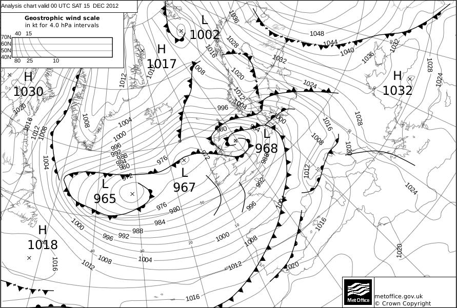
11 The Storm of December 2012 Press and Journal, 12 th January

 12 to 24 hours lead time Offshore waves forecast 5m to")
12 Coastal flooding threat (Thursday 13 th ) 36 to 48 hours lead time Offshore waves forecast 3m to 4.5m Coastal impacts possible for East Coast Flood Alert issued Coastal flooding threat (Friday 14 th ) 12 to 24 hours lead time Offshore waves forecast 5m to 8m Flooding impacts likely due to wave impacts Flood Warnings 12
13 13


14 Islands: Road damage and closures Wick and Brora: Damage to harbour, properties flooded and A9 closed due to flooding. Highland Council reporting 2m damages Moray coastal villages: Sea defences and harbours damaged Peterhead and Stonehaven: Properties and infrastructure flooded, some evacuations Fife coast: Sea defences and harbours damaged, risk to properties The Storm of December 2012 Coastal Forecasts Near shore waves of 1 to 2 metres forecast Significant wave overtopping predicted in Kirkcaldy Warnings issued Emergency Response Road closures, especially along Kirkcaldy promenade Damage to two 20 metre sections of sea defences 14
15 Culross, Longannet and Kincardine Flood warning threshold 3.94 maod Alloa (not a flood warning location) Top level of Quay 3.55 maod Grangemouth Flood warning threshold 3.94 maod Culross, Longannet and Kincardine 6 Dec 4.32 predicted 4 Jan 4.23 predicted Alloa (survey levels) 5 th /6 th Dec 4.26 maod 4 th Jan 4.11 maod Grangemouth 6 Dec 4.37 predicted (4.25 observed) 4 Jan 4.28 predicted (4.18 observed) 15

 Photo: Musselburgh at")
16 December 5/6 Event Analysis Grangemouth Observed 5 th Dec 3.7 maod 6 th Dec 4.25 maod Forecast 5 th Dec 4.04 maod 6 th Dec 4.37 maod Photo: Looking upstream from A904 in Grangemouth on the peak of the tide/surge on the 5 th December (Source: JBA Consulting) Photo: Musselburgh at peak tide/surge (source: JBA Consulting) 16


17 In summary Major new flood warning scheme launched for Scotland s critical communities in December 2012 Based on latest science developments for forecasting tide, surge and wave impacts Delft FEWS system used to integrate Met Office offshore coastal data with near shore assessment Enabled better flooding response during the storm of December 2012 and December 2013 / January 2014 Increased awareness of coastal flooding issue The wave transformation and overtopping calculations do lead to some false warnings needs to be reviewed and improved THANK YOU Q & A 34 17
Predicting present and future coastal flood risk in North East Wales
 Predicting present and future coastal flood risk in North East Wales Fay Fishford & Thomas Bennett-Lloyd, JBA Consulting Benjamin Hext, Natural Resources Wales 1 st International Workshop on Waves, Storm
Relative sea level change across the Forth Estuary. Dr. Victoria Powell University of Chester
 Relative sea level change across the Forth Estuary Dr. Victoria Powell University of Chester v.powell@chester.ac.uk Forth Estuary Forum Annual Conference, 17 th November 2016 Sea Level Change Global sea
Using Weather Pattern Analysis to Identify Periods of Heightened Coastal Flood Risk in the Medium to Long Range
 UEF 2017 - Storms Using Weather Pattern Analysis to Identify Periods of Heightened Coastal Flood Risk in the Medium to Long Range David Price (FFC) and Robert Neal (Met Office) Thursday 15 June The Flood
Floodplain Risk Management in Dungog after the April 2015 Super Storm. Presentation Outline
 Presentation Outline Floodplain Risk Management in after the April 2015 Super Storm Rohan Hudson, Royal HaskoningDHV FMA 2017 Preparing for the Next Great Flood 17th May 2017 Background and Flood Mechanisms
Flood Risk Mapping and Forecasting in England
 Flood Risk Mapping and Forecasting in England Mark Franklin Environment Agency, England NORDESS Workshop on Risk Assessment and Acceptable Risk Outline Flood risk in England Who we are and how we work
Smart Flood Risk Management Solutions
 Smart Flood Risk Management Solutions - RHDHV s Experience in the Gulf of Mexico Mathijs van Ledden, Marten Hillen and Ries Kluskens Challenge Extreme weather around the world (hurricanes, cyclones, extratropical
The UK Flood Forecasting Centre
 Storm Surge Networking Forum, Venice: Tuesday 19 th November 2013 The UK Flood Forecasting Centre Dave Cox - Senior Hydrometeorologist FFC Exeter, England. In My talk today I will cover: Ü Overview of
Improving global coastal inundation forecasting WMO Panel, UR2014, London, 2 July 2014
 Improving global coastal inundation forecasting WMO Panel, UR2014, London, 2 July 2014 Cyclone Sidr, November 2007 Hurricane Katrina, 2005 Prof. Kevin Horsburgh Head of marine physics, UK National Oceanography
Hydraulic Modelling for Real Time Flood Forecast Applications
 BHS/CIWEM SW Branch Meeting Hydraulic Modelling for Real Time Flood Forecast Applications Yiping Chen 20 June 2007 Introduction Hydraulic River Modelling: Washland (Floodplain) Modelling Techniques Integrated
County Clare Flood Forecasting System
 County Clare Flood Forecasting System Paul Moroney BE (Civil), C. Eng. M.I.E.I. M.C.I.Arb. Head of the Environment Section Clare County Council (The views expressed in this paper represent the professional
Integrating Hydrologic and Storm Surge Models for Improved Flood Warning
 Integ Hydrologic and Storm Surge Models for Improved Flood Warning Leahy, C.P, Entel, M, Sooriyakumaran, S, and Warren, G Flood Warning Program Office, Bureau of Meteorology, Docklands, Victoria National
Belfast Sea Level Rise A Briefing for Policy Makers
 Belfast Sea Level Rise A Briefing for Policy Makers Version 3, issued 16/02/17 This paper briefly sets out the relative current rate of sea level rise in Belfast, and how this increases the risk of coastal
Probabilistic Coastal Flood Forecasting Nigel Tozer HR Wallingford
 Probabilistic Coastal Flood Forecasting Nigel Tozer HR Wallingford Peter Hawkes, Tim Pullen, HR Wallingford Angela Scott, UKCMF / Environment Agency Jonathan Flowerdew, Ken Mylne, Francois Xavier-Bocquet,
Impact of Sea Level Rise on Future Storm-induced Coastal Inundation
 Impact of Sea Level Rise on Future Storm-induced Coastal Inundation Changsheng Chen School for Marine Science and Technology, University of Massachusetts-Dartmouth Email: c1chen@umassd.edu 04/14/2015 Outline
Hurricane Harvey: SE Texas Impacts. 10 PM CDT UPDATE Friday, August 25, 2017 Prepared by: Lance Wood
 Hurricane Harvey: SE Texas Impacts 10 PM CDT UPDATE Friday, August 25, 2017 Prepared by: Lance Wood Latest Observations Hurricane Harvey making landfall this evening near Rockport as a category 4 hurricane.
JCOMM-CHy Coastal Inundation Forecasting Demonstration Project (CIFDP)
") WMO World Meteorological Organization Working together in weather, climate and water JCOMM-CHy Coastal Inundation Forecasting Demonstration Project (CIFDP) Coastal Flooding & Vulnerable Populations Coastal
WMO World Meteorological Organization Working together in weather, climate and water JCOMM-CHy Coastal Inundation Forecasting Demonstration Project (CIFDP) Coastal Flooding & Vulnerable Populations Coastal
Coastal Inundation Forecasting Demonstration Project CIFDP. Flood Forecasting Initiative-Advisory Group (FFI-AG 3), Geneva, 5-7 Dec, 2017
, Geneva, 5-7 Dec, 2017") Coastal Inundation Forecasting Demonstration Project CIFDP Flood Forecasting Initiative-Advisory Group (FFI-AG 3), Geneva, 5-7 Dec, 2017 Coastal Flooding & Vulnerable Populations Coastal populations are
Coastal Inundation Forecasting Demonstration Project CIFDP Flood Forecasting Initiative-Advisory Group (FFI-AG 3), Geneva, 5-7 Dec, 2017 Coastal Flooding & Vulnerable Populations Coastal populations are
Major Hurricane Matthew Briefing Situation Overview
 Major Hurricane Matthew Briefing Situation Overview THIS IS NOW A WORST CASE STORM SURGE SCENARIO Catastrophic Damage is Anticipated for Coastal Areas. Major Hurricane Matthew is still expected to move
NOAA s National Weather Service Philadelphia/Mt. Holly NJ
 Next Briefing Package: Thursday, October 1, 2015 no later than 300 PM Hazards and Impacts: Overview: A dangerous weather pattern is developing for our region. Threats include very heavy rainfall, inland
Extending the use of Flood Modeller Pro towards operational forecasting with Delft-FEWS
 Extending the use of Flood Modeller Pro towards operational forecasting with Delft-FEWS Simone van Schijndel, Department Head Operational Water Management and Early Warning Intentionally blank The world
Flood Risk Forecasts for England and Wales: Production and Communication
 Staines Surrey Flood Risk Forecasts for England and Wales: Production and Communication Jon Millard UEF 2015 : Quantifying and Communicating Uncertainty FFC What is the FFC? Successful partnership between
Wainui Beach Management Strategy (WBMS) Summary of Existing Documents. GNS Tsunami Reports
 Summary of Existing Documents. GNS Tsunami Reports") Wainui Beach Management Strategy (WBMS) Summary of Existing Documents GNS Tsunami Reports a) Review of Tsunami Hazard and Risk in New Zealand ( National Risk Report ) b) Review of New Zealand s Preparedness
Wainui Beach Management Strategy (WBMS) Summary of Existing Documents GNS Tsunami Reports a) Review of Tsunami Hazard and Risk in New Zealand ( National Risk Report ) b) Review of New Zealand s Preparedness
Mapping of Future Coastal Hazards. for Southern California. January 7th, David Revell, Ph.D. E.
 Mapping of Future Coastal Hazards for Southern California January 7th, 2014 David Revell, Ph.D. drevell@esassoc.com E. Vandebroek, 2012 Outline Coastal erosion hazard zones Flood hazard zones: Coastal
Flooding and Climate Change APSE Seminar, 9 February 2017
 Flooding and Climate Change APSE Seminar, 9 February 2017 Local Roads Maintenance 1 Department for Transport OFFICIAL Preparations for Winter Important the transport sector, including local highway authorities,
NOAA s National Weather Service Philadelphia/Mt. Holly NJ
 Next Briefing Package: Friday, October 2, 2015 no later than 300 PM Hazards and Impacts: Overview: A dangerous weather pattern still threatens our region. Threats include very heavy rainfall, inland river
RISC-KIT: EWS-DSS Hotspot Tool
 RISC-KIT: EWS-DSS Hotspot Tool Robert McCall Ap van Dongeren Deltares www.risckit.eu This project has received funding from the European Union s Seventh Programme for Research, Technological Development
Hurricane Harvey: SE Texas Impacts. 10 AM CDT UPDATE Saturday, August 26, 2017 Prepared by: Dan Reilly, Brian Kyle
 Hurricane Harvey: SE Texas Impacts 10 AM CDT UPDATE Saturday, August 26, 2017 Prepared by: Dan Reilly, Brian Kyle Latest Observations and Radar Hurricane Harvey centered near Victoria and weakening Wind
Forecasting Flood Risk at the Flood Forecasting Centre, UK. Delft-FEWS User Days David Price
 Forecasting Flood Risk at the Flood Forecasting Centre, UK Delft-FEWS User Days 2012 David Price Overview of the Flood Forecasting Centre (FFC) What is the FFC? Partnership between the Met Office and Environment
Adapting NEMO for use as the UK operational storm surge forecasting model
 Adapting NEMO for use as the UK operational storm surge forecasting model Rachel Furner 1, Jane Williams 2, Kevin Horsburgh 2, Andy Saulter 1 1; Met Office 2; NOC Table of Contents Existing CS3 model Developments
Major Hurricane Matthew Briefing Situation Overview
 Major Hurricane Matthew Briefing Situation Overview At 5 p.m. Tuesday, Category 4 Hurricane Matthew was about 860 miles South-Southeast of Mayport, Florida, moving north around 10 mph. Maximum sustained
NOAA Inundation Dashboard
 NOAA Inundation Dashboard Audra Luscher & Paul Fanelli NOS Center for Operational Oceanographic Products & Services (CO-OPS) Hampton Roads Sea Level Rise/Flooding Adaptation Forum July 29, 2016 http://tidesandcurrents.noaa.gov/inundationdb/newyork.html
NWS HURRICANES June 3, 2015
 NWS HURRICANES June 3, 2015 Hurricane Season June 1 November 30 2 What s the concern? All tropical systems passing within 125nm of central Maryland since 1950 Mid-Atlantic Hurricanes Greatest Risk: August
Satellite and Radar. 5:55 am Infrared Satellite with Surface Wind Arrows. 6:15 am Ruskin Doppler Radar. Large southerly wind field
 Satellite and Radar 5:55 am Infrared Satellite with Surface Wind Arrows 6:15 am Ruskin Doppler Radar Large southerly wind field Developing showers rotating onshore NHC Forecast Hurricane Warning Big Bend
Coastal Storms of the New Jersey Shore
 Coastal Storms of the New Jersey Shore Dr. Steven G. Decker Dept. of Environmental Sciences School of Environmental and Biological Sciences Rutgers University May 25, 2011 Overview Threats Historical Examples
The Winter Storm of January 4 and 5, 2018
 The Winter Storm of January 4 and 5, 2018 A winter storm hit the Maritime Provinces on January 4 th and 5 th, 2018. Environment Canada forecasts for the storm predicted high winds from the east, south,
LONDON & TE December 2009
 LONDON & TE2100 10 December 2009 Tim Reeder Environment Agency How is London vulnerable to CC? Flooding Overheating Water resources Air Quality Subsidence and heave Wind storms Global climate events What
Tropical Storm Harvey: SE Texas Impacts
 Tropical Storm Harvey: SE Texas Impacts 10 AM CDT UPDATE Thursday, August 24, 2017 Prepared by: Dan Reilly, Brian Kyle PLEASE MUTE YOUR LINES AND DON T PUT ON HOLD! Situation Overview Tropical Storm Harvey
Hydrological forecasting and decision making in Australia
 Hydrological forecasting and decision making in Australia Justin Robinson, Jeff Perkins and Bruce Quig Bureau of Meteorology, Australia The Bureau's Hydrological Forecasting Services Seasonal Forecasts
Dynamic Coast. Coastal erosion / Management Briefing to THC
 Dynamic Coast Coastal erosion / Management Briefing to THC What is Dynamic Coast? Dynamic Coast is a Scottish Government project, funded by CREW, managed by SNH, with a research team from the University
Tools to Assess Flood Risk of Commercial Property Investment
 Tools to Assess Flood Risk of Commercial Property Investment NSERC Workshop March 1, 2016 Kate Collins, Tim Webster, Nathan Crowell AGRG, NSCC, Middleton, NS https://eatsleepride.com/ http://users.eastlink.ca/~tbulley/
Active Weather Threat Halloween Week Nor easter October 28 th 31 st 2012
 Active Weather Threat Halloween Week Nor easter October 28 th 31 st 2012 Prepared 1130 AM EDT Wednesday, October 24, 2012 Gary Szatkowski NOAA s NJ Forecast Office Weather.gov/phi Purpose of Briefing Briefing
"Outcomes of the storm surge and waves workshop in Dominican Republic and the questionnaire"
 "Outcomes of the storm surge and waves workshop in Dominican Republic and the questionnaire" Strengthening Regional Cooperation to Support Forecasting with Multi Hazard Approach in RA IV Ritz Carlton Grand
Climate Change Impacts and Adaptation for Coastal Transport Infrastructure in Caribbean SIDS
 UNCTAD National Workshop Saint Lucia 24 26 May 2017, Rodney Bay, Saint Lucia Climate Change Impacts and Adaptation for Coastal Transport Infrastructure in Caribbean SIDS LISCoAsT Large Scale Integrated
Tropical Update. 11 AM EDT Tuesday, October 9, 2018 Hurricane Michael, Tropical Storm Leslie, Tropical Storm Nadine
 Tropical Update 11 AM EDT Tuesday, October 9, 2018 Hurricane Michael, Tropical Storm Leslie, Tropical Storm Nadine This update is intended for government and emergency response officials, and is provided
A Detailed First Pass coastal hazard assessment for a long complex coast: Kingborough LGA, Tasmania
 A Detailed First Pass coastal hazard assessment for a long complex coast: Kingborough LGA, Tasmania Chris Sharples & Paul Donaldson University of Tasmania September 2012 Kingborough LGA, south-eastern
Coastal flood risk from storm surge to inundation. Introduction Peter Stansby University of Manchester. 26 May 2011
 Climate GCM RCM (Met Office) www.floodrisk.org.uk Coastal flood risk from storm surge to inundation Introduction Peter Stansby University of Manchester EPSRC Grant: EP/FP202511/1 ROAD MAP Historical ERA-40
Major Hurricane Earl
 Major Hurricane Earl Advisory 32 North Carolina Threat Assessment Prepared at: 8 AM Thursday September 2, 2010 Hurricane and Tropical Storm Warnings in effect for the North Carolina Coast and Sounds. NWS
TROPICAL STORM NATE BRIEFING
 TROPICAL STORM NATE BRIEFING 2:00 PM CDT Friday, October 06, 2017 Prepared by: NWS NWSNewOrleans www.weather.gov/neworleans Situation Overview Track forecast has not changed since the 10 am advisory. Hurricane
Flash Flood Guidance System On-going Enhancements
 Flash Flood Guidance System On-going Enhancements Hydrologic Research Center, USA Technical Developer SAOFFG Steering Committee Meeting 1 10-12 July 2017 Jakarta, INDONESIA Theresa M. Modrick Hansen, PhD
Coastal Inundation Forecasting and Community Response in Bangladesh
 WMO Coastal Inundation Forecasting and Community Response in Bangladesh Bapon (SHM) Fakhruddin Nadao Kohno 12 November 2015 System Design for Coastal Inundation Forecasting CIFDP-PSG-5, 14-16 May 2014,
Weather forecasts and warnings: Support for Impact based decision making
 Weather forecasts and warnings: Support for Impact based decision making Gerry Murphy, Met Éireann www.met.ie An Era of Change Climate and weather is changing Societal vulnerability is increasing The nature
Tropical Cyclone Oswald Coastal Monitoring
 Tropical Cyclone Oswald Coastal Monitoring Kieran Harper and John Maher Coastal Impacts Unit, Queensland Department of Science, Information Technology, Innovation and the Arts (DSITIA). 27 Quinlan St Deagon,
National Report of New Zealand
 National Report of New Zealand Prepared for GLOSS Training Course Tokyo May 2006 Glen Rowe Data Analyst Hydrographic Services Land Information New Zealand National Office 160 Lambton Quay Wellington New
TROPICAL STORM NATE BRIEFING
 TROPICAL STORM NATE BRIEFING 10:30 AM CDT Friday, October 06, 2017 Prepared by: NWS NWSNewOrleans www.weather.gov/neworleans Situation Overview Track forecast has shifted slightly eastward. Hurricane Watch
Lessons Learned from Past Tsunamis Warning and Emergency Response
 UNESCO IOC CTIC US NOAA ITIC Regional Training Workshop on Strengthening Tsunami Warning and Emergency Response Standard Operating Procedures and the Development of the ICG/CARIBE-EWS PTWC New Enhanced
Case Study: Modeling the Bundaberg Floods. Sudesh Mudaliar, VP Asia Pacific Anthony Kuch, VP North America
 Case Study: Modeling the Bundaberg Floods Sudesh Mudaliar, VP Asia Pacific Anthony Kuch, VP North America Bundaberg Case Study Burnett River Flood Events Flood Damage Impacts Surveying & LiDAR Current
Holderness Erosion and Evolution of the Spurn Peninsula
 Holderness Erosion and Evolution of the Spurn Peninsula Prof. Ken Pye and Dr. Simon Blott Kenneth Pye Associates Ltd. Outline of the Presentation Overview of historical erosion trends Effects of coast
Vulnerability of Bangladesh to Cyclones in a Changing Climate
 Vulnerability of Bangladesh to Cyclones in a Changing Climate Susmita Dasgupta Kiran Pandey Mainul Huq Zahirul Huq Khan M.M. Zahid Ahmed Nandan Mukherjee Malik Fida Khan 2010 Bangladesh: Tropical Cyclone
C o p e r n i c u s E m e r g e n c y M a n a g e m e n t S e r v i c e f o r e c a s t i n g f l o o d s
 C o p e r n i c u s E m e r g e n c y M a n a g e m e n t S e r v i c e f o r e c a s t i n g f l o o d s Copernicus & Copernicus Services Copernicus EU Copernicus EU Copernicus EU www.copernicus.eu W
Modelling Coastal Environments Professional Consulting Services Coastal Inundation Tsunamis Coastal Hazard Adaptation Strategies Coastal Processes
 Modelling Coastal Environments Professional Consulting Services Coastal Inundation Tsunamis Coastal Hazard Adaptation Strategies Coastal Processes bmtwbm.com.au Coastal Inundation Risk Assessments Long-term
Tsunami Response and the Enhance PTWC Alerts
 Tsunami Response and the Enhance PTWC Alerts Ken Gledhill GeoNet Project Director Chair, Intergovernmental Coordination Group, Pacific Tsunami Warning and Mitigation System (PTWS) Overview 1. Procedures
California OES Weather Threat Briefing
 California OES Weather Threat Briefing Wednesday, January 16, 2019 9:00 AM PST Day 1: Strong winds, heavy mountain snow and heavy rain with isolated thunderstorms across much of the state through Thursday
Delft-FEWS User Days 2 nd & 3 rd November 2011
 Delft-FEWS User Days 2 nd & 3 rd November 2011 Recent developments in EA Midlands Flood Forecasting using FEWS NFFS Ian Clayton Flood Forecasting Technical Specialist Environment Agency Midlands Flood
DRAFT - Tsunami Response Plan Playbook Santa Cruz Harbor Maritime Community
 DRAFT - Tsunami Response Plan Playbook Santa Cruz Harbor Maritime Community Page 1 Best to display on 11X17 paper Purpose and Use of this Real-time Tsunami Response Plan Playbook PURPOSE: This product
Tropical Update. 5 AM EDT Tuesday, September 12, 2017 Post-Tropical Cyclone Irma, Hurricane Jose, & Tropical Wave (10%)
") Tropical Update 5 AM EDT Tuesday, September 12, 2017 Post-Tropical Cyclone Irma, Hurricane Jose, & Tropical Wave (10%) This update is intended for government and emergency response officials, and is provided
Tropical Update 5 AM EDT Tuesday, September 12, 2017 Post-Tropical Cyclone Irma, Hurricane Jose, & Tropical Wave (10%) This update is intended for government and emergency response officials, and is provided
Weather briefing Strong Coastal Nor easter November 7 th -8 th, 2012
 Weather briefing Strong Coastal Nor easter November 7 th -8 th, 2012 Prepared 1245 PM EDT Tuesday November 6, 2012 Gary Szatkowski NOAA s NJ Forecast Office Weather.gov/phi Purpose of Briefing Briefing
CLIMATE CHANGE ON THE SEVERN ESTUARY Sea level
 CLIMATE CHANGE ON THE SEVERN ESTUARY Sea level Introduction The marine environment of the Severn Estuary is one of the most dynamic in Europe and sea level, waves and storms all play their part in shaping
HURRICANE IRENE. CONFERENCE CALL BRIEFING SLIDES Saturday August 27, :30 AM
 HURRICANE IRENE CONFERENCE CALL BRIEFING SLIDES Saturday August 27, 2011 8:30 AM NHC TRACK AND CONE HURRICANE IRENE WATCHES/WARNINGS Hurricane Warning along south coast including all of Cape Cod and Islands
Very Dangerous Coastal Storm Sandy October 28 th 31 st 2012
 Very Dangerous Coastal Storm Sandy October 28 th 31 st 2012 Prepared 600 PM EDT Monday October 29, 2012 Gary Szatkowski NOAA s NJ Forecast Office Weather.gov/phi Purpose of Briefing Briefing #11 for event
Residents Emergency Response Checklist
 COMMUNITY RESILIENCE PLAN Residents Emergency Response Checklist A helpful guide in the event of extreme weather or bushfire events. < PREVIOUS I NEXT > 02 Purchasing an existing property or building a
Preliminary Vulnerability Assessment of Coastal Flooding Threats - Taylor County, Florida
 Preliminary Vulnerability Assessment of Coastal Flooding Threats - Taylor County, Florida North Central Florida Regional Planning Council Northeast Florida Regional Council April 28, 2016 BACKGROUND This
Hurricane Matthew Threats and Impacts Briefing for Eastern NC
 Hurricane Matthew Threats and Impacts Briefing for Eastern NC October 6 th, 2016 Date/Time Created: 10/6/2016, Noon EDT National Weather Service Newport/Morehead City, NC Hurricane Matthew Key Points Changes
Tropical Update. 11 AM EDT Wednesday, October 10, 2018 Hurricane Michael, Hurricane Leslie & Tropical Storm Nadine, Caribbean Low (40%)
") Tropical Update 11 AM EDT Wednesday, October 10, 2018 Hurricane Michael, Hurricane Leslie & Tropical Storm Nadine, Caribbean Low (40%) This update is intended for government and emergency response officials,
Tropical Update 11 AM EDT Wednesday, October 10, 2018 Hurricane Michael, Hurricane Leslie & Tropical Storm Nadine, Caribbean Low (40%) This update is intended for government and emergency response officials,
1.2 DEVELOPMENT OF THE NWS PROBABILISTIC EXTRA-TROPICAL STORM SURGE MODEL AND POST PROCESSING METHODOLOGY
 1.2 DEVELOPMENT OF THE NWS PROBABILISTIC EXTRA-TROPICAL STORM SURGE MODEL AND POST PROCESSING METHODOLOGY Huiqing Liu 1 and Arthur Taylor 2* 1. Ace Info Solutions, Reston, VA 2. NOAA / NWS / Science and
Assessing Storm Tide Hazard for the North-West Coast of Australia using an Integrated High-Resolution Model System
 Assessing Storm Tide Hazard for the North-West Coast of Australia using an Integrated High-Resolution Model System J. Churchill, D. Taylor, J. Burston, J. Dent September 14, 2017, Presenter Jim Churchill
Storm Surge Forecast with Shifting Forecast Tracks
 Storm Surge Forecast with Shifting Forecast Tracks Storm Surge Findings in the Florida Keys Jon Rizzo Warning Coordination Meteorologist National Weather Service Florida Keys Florida Keys Life History
COMPOUND FLOODING: EXAMPLES,
 1 COMPOUND FLOODING: EXAMPLES, METHODS, AND CHALLENGES Thomas Wahl Civil, Environmental and Construction Engineering & National Center for Integrated Coastal Research University of Central Florida Definition(s)
Scenarios for the NI coast in the 21 st Century
 Scenarios for the NI coast in the 21 st Century Prof Julian Orford Geography, Archaeology & Palaeoecology Queen s University, Belfast Challenging perspective Living by the coast is good for your health!
Simulation of storm surge and overland flows using geographical information system applications
 Coastal Processes 97 Simulation of storm surge and overland flows using geographical information system applications S. Aliabadi, M. Akbar & R. Patel Northrop Grumman Center for High Performance Computing
Storm surge forecasting and other Met Office ocean modelling
 Storm surge forecasting and other Met Office ocean modelling EMODnet stakeholder meeting Clare O Neill + many others Outline Ocean modelling at the Met Office Storm surge forecasting Current operational
Major Hurricane Earl
 Major Hurricane Earl Advisory 33 North Carolina Threat Assessment Prepared at: 11 AM Thursday September 2, 2010 Hurricane and Tropical Storm Warnings in effect for the North Carolina Coast and Sounds NWS
Hurricane Sandy October 28 th 31 st 2012
 Hurricane Sandy October 28 th 31 st 2012 Prepared 530 PM EDT Saturday October 27, 2012 Gary Szatkowski NOAA s NJ Forecast Office Weather.gov/phi Purpose of Briefing Briefing #7 for event Promote situational
Coastal Storm this Weekend
 Weather Briefing Prepared 9 AM EST Feb 5, 2010 Joe Miketta Warning Coordination Meteorologist NOAA s National Weather Service Philadelphia/Mt. Holly NJ Forecast Office 609-261 261-6602 6602 x223 Joseph.Miketta@noaa.gov
Sea Level Rise and Coastal Inundation Thursday 11 th October, 2012, 1.00pm, With lunch in the Legislative Council Committee Room
 The Presiding Officers invite Parliamentarians and Staff to a Science Briefing on Sea Level Rise and Coastal Inundation Thursday 11 th October, 2012, 1.00pm, With lunch in the Legislative Council Committee
Significant Coastal Storm Today through Thursday, 11/7-8. Weather Briefing
 Significant Coastal Storm Today through Thursday, 11/7-8 Weather Briefing Prepared 10:00 am EST Wednesday, November 7, 2012 Presented by Gary Conte, Warning Coordination Meteorologist NOAA s National Weather
Coupling of Wave and Hydrodynamic Models for Predicting Coastal Inundation: A case study in Jakarta and Semarang
 Coupling of Wave and Hydrodynamic Models for Predicting Coastal Inundation: A case study in Jakarta and Semarang http://peta-maritim.bmkg.go.id/cifdp/maps Nelly Florida Riama,Andri Ramdhani, Andi Eka Sakya,,
A probabilistic storm surge risk model for the German North and Baltic Sea coast
 A probabilistic storm surge risk model for the German North and Baltic Sea coast Jan-Henrik Grabbert 1), Jan Deepen 2), Andreas Reiner 2), Stephan Mai 3), Harvey Rodda 4), Dietmar Pfeifer 5) and Andreas
Hindcast Arabian Gulf
 Hindcast Arabian Gulf Image of isobars of atmospheric pressure and hindcast wind- and wave field over the Arabian Gulf during a storm in January 1993. Detailed wave studies are supported by nesting of
Progress Report. Flood Hazard Mapping in Thailand
 Progress Report Flood Hazard Mapping in Thailand Prepared By: Mr. PAITOON NAKTAE Chief of Safety Standard sub-beuro Disaster Prevention beuro Department of Disaster Prevention and Mitigation THAILAND E-mail:
NOAA s National Weather Service Philadelphia/Mt. Holly NJ. Summary. Changes
 Summary A crippling and potentially historic east coast snow storm will lead to blizzard conditions and major coastal flooding for portions of the area this weekend. Changes Blizzard Warning has been expanded
HURRICANE HARVEY COE Navigation BRIEFING
 HURRICANE HARVEY COE Navigation BRIEFING 10:00 AM CDT Friday, August 25, 2017 NWSNewOrleans www.weather.gov/neworleans Situation Overview New Information Harvey continues to strengthen Max sustained winds
TROPICAL STORM HARVEY BRIEFING
 TROPICAL STORM HARVEY BRIEFING 10:00 AM CDT Sunday, August 27, 2017 Prepared by: NWS LIX NWSNewOrleans www.weather.gov/neworleans Situation Overview New Information Tropical Storm Winds 40mph Immediate
New Storm Surge Catastrophe Model for Great Britain and Beyond
 New Storm Surge Catastrophe Model for Great Britain and Beyond Richard Yablonsky, Mohammad Keshtpoor, and Austen Blair 33 rd Conference on Hurricanes and Tropical Meteorology American Meteorological Society
Tropical Cyclones Modelling For Natural Disaster Risk Management
 Tropical Cyclones Modelling For Natural Disaster Risk Management Juan Savioli a, M. Britton b, S. Szylkarski a and Claus Pederson a a DHI Water and Environment, 2 Elliott Street, Suite 1a, QLD 4217 Surfers
Tsunami Risk Mitigation Strategy for Thailand. Kjell Karlsrud Norwegian Geotechnical Institute (NGI)
") Tsunami Risk Mitigation Strategy for Thailand Kjell Karlsrud Norwegian Geotechnical Institute (NGI) The project was undertaken by NGI in cooperation with: NORSAR, UiB, UiO, NIBR, B.Heyerdahl, NTNU, Sintef
Tsunami Risk Mitigation Strategy for Thailand Kjell Karlsrud Norwegian Geotechnical Institute (NGI) The project was undertaken by NGI in cooperation with: NORSAR, UiB, UiO, NIBR, B.Heyerdahl, NTNU, Sintef
Advisory #35 Briefing 630 PM EDT Thursday October 06, 2016
 Advisory #35 Briefing 630 PM EDT Thursday October 06, 2016 Disclaimer: The information contained within this briefing is time-sensitive, do not use beyond 6 hours after the issuance Next Webinar Update:
MODELLING CATASTROPHIC COASTAL FLOOD RISKS AROUND THE WORLD
 MODELLING CATASTROPHIC COASTAL FLOOD RISKS AROUND THE WORLD Nicola Howe Christopher Thomas Copyright 2016 Risk Management Solutions, Inc. All Rights Reserved. June 27, 2016 1 OUTLINE MOTIVATION What we
Hurricane Matthew. Life Threatening Flash Flooding Likely. National Weather Service Wilmington NC. Josh Weiss, Meteorologist
 Hurricane Matthew Life Threatening Flash Flooding Likely Threat Assessment for northeast South Carolina & southeast North Carolina National Weather Service Wilmington NC 630 PM EDT Friday October 7, 2016
Flooding Performance Indicator Summary. Performance indicator: Flooding impacts on riparian property for Lake Ontario and the Upper St.
 Flooding Performance Indicator Summary Performance indicator: Flooding impacts on riparian property for Lake Ontario and the Upper St. Lawrence River Technical Workgroup: Coastal TWG Research by: Baird