County Clare Flood Forecasting System
|
|
|
- Ariel Weaver
- 5 years ago
- Views:
Transcription
1 County Clare Flood Forecasting System Paul Moroney BE (Civil), C. Eng. M.I.E.I. M.C.I.Arb. Head of the Environment Section Clare County Council (The views expressed in this paper represent the professional views of the author and not the views of Clare County Council)
2 Flooding in County Clare November 2009 November 2009 notable for high rainfall recorded and severe flooding. Rainfall totals for November were the highest on record. Two-day falls of over 100mm were recorded in parts of the west and southwest on the 18th/19th. 28 day rain totals at Shannon in November 2009 were 270mm
3 Flooding in County Clare November 2009 River Flows on the Fergus in Ennis peaked at 80 cumecs on November 19 th and 24 th. These river flows were the highest on record. These flows lead to significant town centre flooding in Ennis River Flows on the Shannon peaked on November 28 th at 920 cumecs, also the highest on record These flows lead to significant flooding in South East Clare.
4 Flood Forecasting System During the flood events: Immersed in emergency response and management. After the events: developed an interest in the river flows and levels. Excellent national Weather warning systems in place. No national or regional flood forecasting system existed. Could a flood forecasting system be developed from existing data sources To suit County Clare's needs until a better system came online.
5 Existing data sources OPW river gauges, Ballycoree, Inch Corofin over 50 years of records Met Eireann rain gauges, Shannon Airport CSO reports Shannon Foynes Port tides prediction and gauges Ennis Flood Study from 2001 ESB records and documents European Flood Advisory System EFAS
6 Shannon Airport Rainfall records Period from 1958 to 2010 analysed. Reasonably low number of records where cumulative monthly rain amounts exceeds 170mm Monthly rain totals exceeding 200mm generally co-incide with town centre flooding in Ennis Large daily maximum rain amounts at Shannon have not generally correlated with winter flooding to date All historical floods in 50 years in Ennis are in Nov, Dec, Jan or Feb

7 November 2009 Monthly total at Shannon 263mm 277% of normal November rain
8 Shannon Monthly rain totals cumulative monthly rain Monthly totals > 170mm Oct Nov Dec Jan Feb Mar month Source CSO and Met Eireann
9 River Fergus Ballycoree flow records Range of records is from 1958 to 2010 Flows greater than 40 cumecs generally result in flooding in flood plains. Flows greater that 50 cumecs generally result in town centre flooding Highest flows occur between 5 and 7 days after maximum rain Average flows at Ballycoree have increased from 10 cumecs to 11.4 cumecs over the 50 year period
10 OPW Ballycoree Fergus flow November 2009 Max flow at Ballycoree 79.9 cumecs 24 th November flow (cumecs) flow cumecs /01/ /01/ /01/ /01/ /01/ /01/ /01/ /01/ /01/ /01/ /01/ /01/ /01/ /01/ /01/ /01/ /01/ /01/ /01/ /01/ /01/ /01/ /01/ /01/ /01/ /01/ /01/ /01/2010 Source: OPW date
11 OPW Ballycoree flood comparisons flow (cumecs) Oct 1 Oct 7 Oct 13 Oct 19 Oct 25 Oct 31 Nov 6 Nov 12 Nov 18 Nov 24 Nov 30 Dec 6 Dec 12 Dec Dec 24 date in winter season Dec 30 Jan 5 Jan 11 Jan 17 Jan 23 Jan 29 Feb 4 Feb 10 Feb 16 Feb 22 Feb 28 Mar 6 Mar 12 Mar 18 Mar 24 Mar flood 1995 Flood 1999 Flood 2009 Flood 2008 Flood 2006 flood 1993 Flood 1989 Flood Source: OPW
12 Developing a flood model Uses OPW figures for flow at Ballycoree and Claureen Use the 2001 Ennis main drainage report which includes a flood model. This was required due to complicated flow regime, 2 rivers Fergus and Claureen, groundwater, 2 flood channels Predicts flow through the town and the Fergus Minor and in Lower river near Clarecastle A less complicated river with one flow only requires a gauge and some analysis.

13
14 Flood Model No 1 based on River flow Reports on River Flow through the town under Victoria bridge represents fluvial flood risk Reports on daily rain events at Shannon represents pluvial flood risk References fluvial flow to an EFAS type colour coded warning system Analysed regularly during winter (and Summer) flood season Detailed predictions of levels at the nodes for a given flow is available Reported internally in Clare County Council twice weekly during flood risk periods and used as a basis for issuing flood warnings

15
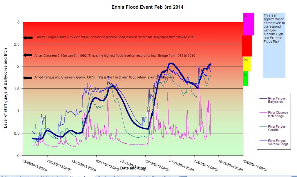
16 Flood Model No 2 based on River levels Reports on River levels for 4 OPW gauges Ballycoree, Corofin and Victoria on the Fergus Inch bridge on the Claureen Referenced to annual average and maxima levels from OPW records, Amed and Amax References river level to EFAS Peak to peak and response times clearly seen Reported internally in Clare County Council twice weekly during flood risk periods and used as a basis for issuing flood warnings
17
18 Features of the model Uses only pre-existing data Based on flood flows detailed level predictions are available for important nodes in the network. Some of these have gauges in situ. Model is well calibrated Uses readily available software easily transportable home/office Reliant on waterlevel.ie web site. When this site is down manual inspection of gauges required In addition at remote locations if internet is down unable to update model Could easily be developed into an APP
19 Features of the model (contd) Is used as a proxy for flooding county wide Has been extended to other river catchments easily albeit with assumptions on flood models Will need to be updated once CFRAMS are in place after 2015 and may be redundant at that stage Will become redundant when national flood forecasting system is rolled out Heavily reliant on a small group of interested and motivated staff No budget, reliant on old technology and old (ish) people
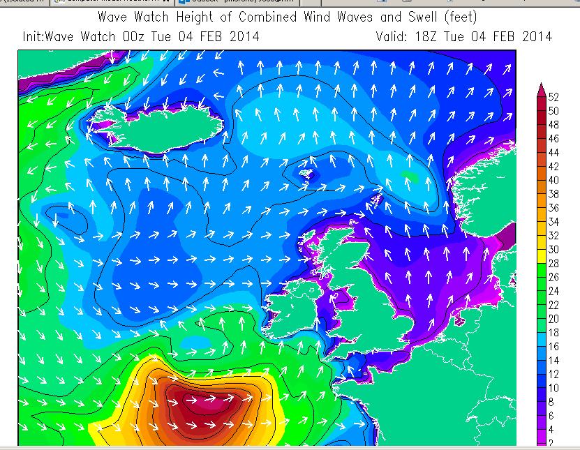
20 Tidal Coastal Flooding Jan/Feb 2014 Issues regarding tidal and coastal flooding were apparent early in Tidal cycle predicted very high spring tides on Jan 3 rd and Feb 1 st 2014 Awareness of coincidence of Atlantic storms with high tides in the winter season was well known Exact details of interaction between Low pressure surge, high winds, wave action and high seas not known in detail OPW ICPSS surge forecast in use for a number of years ICPSS predicts tidal surge at Shannon Approach in the Atlantic at the mouth of the Shannon Estuary
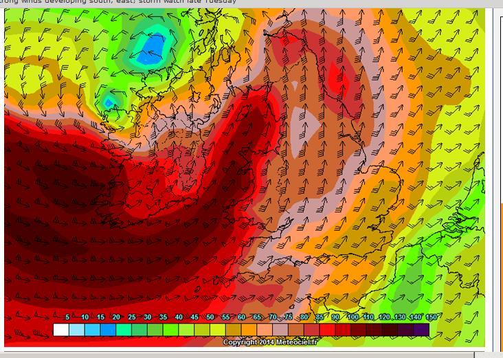
21 Weather Jan/Feb 2014 Jet Stream over Ireland from mid December 2013 at a much lower latitude than normal Conveyor belt of Low pressure systems feeding Atlantic storms onto the west coast Storms on December 23 rd, 27 th, Jan 3 rd, 6 th and Feb 1 st. Many less significant events in between. Co-incidence of Storm conditions, Low Barometric pressure causing surge, High Seas and wave height and strong onshore winds Tide levels known, could surge and flood risk be predicted?
22 Analysis of Storms Dec 27 th extremely low barometric pressure High tides not at spring tide condition Forecast of wave height, surge and tide carried out Gauges at Rossaveal, Fenit, Doonbeg and Clarecastle Based on forecast surge from ICPSS, wave height, wind and barometric pressure flood risk at Clarecastle estimated Flood warning issued County wide tidal and coastal flooding warning for entire Clare coast.

23 Storm surge at Rossaveal Dec 27th Jan 3rd Jan 6th

24 Storm surge at Clarecastle Dec 27th Jan 3rd Jan 6th

25 Surge Analysis of Storms Date Location Surge est Surge act Highest tide level AOD Malin Head Dec 27 th Jan 3 rd Clarecastle 600mm 900mm Jan 6th Clarecastle 500mm 400mm Feb 1st Jan 6 th Clarecastle 300mm 400mm Feb 1st Clarecastle 300mm 270mm 4.225


26 Storm forecasting Feb 1 st 2014

27 Flood Warnings
28 Flood action Flood warnings issued on CCC web site Flood warnings sent via text alert to over 9000 subscribers Closely examine gauges during events to predict and record Actual surge at Rossaveal and Fenit gives a 1 hour warning for Clarecastle Newspaper and media warnings Local radio warnings Pumps, from 300mm to 100mm, Sandbags 1 tonne and regular
29 Issues for the future 1 Many good systems are in place, but they are not co-ordinated They are not all to Malin head datum. Differing datums between tide predictions and gauges leads to confusion Weather prediction systems are not tailored for flood and surge prediction and they could be. Colour code warnings have different colour codes on different systems, e.g. Met Eireann weather warning and EFAS flood warning and UK EA colour codes
30 Issues for the future 2 In an area like the Shannon Estuary the Local authorities and Port Company should co-ordinate flood and surge prediction A detailed flood surge model should be generated for Shannon, Ennis, Kildysart, Kilrush, Carrigaholt, Kilbaha, Kilkee, Doonbeg, Lahinch Liscannor, Ballyvaughan, etc The ICPSS gives good warnings but has only 2 analysis points on the west coast Shannon approach and Galway bay ICPSS does not report on actual surge just predicted On the west coast and Estuary there is a lack of tidal gauges for reporting and analysis
31 Issues for the future 3 Due to extreme nature of forecasts difficulty with comprehending communicating and being understood Everyone has an opinion on the weather, some of it wrong Prolonged weather events lead to desensitization, complacency and fatigue There is a tendency to put effort into response as opposed to preparedness A credible national flood forecasting, flood warning and flood action system is required
32 Real time video Lahinch Jan 3rd Video from Clare County Council Bottle Banks at the playground Lahinch High tide was at 6.00am First signs of flooding at 3.40am over 2 hours before high tide Prolonged damaging surge effects Extreme Flood Hazard The tide came in for 2 hours before peak and took 2 hours to go out in the dark This flood caused damage to 35 different locations on the Clare coast
The UK Flood Forecasting Centre
 Storm Surge Networking Forum, Venice: Tuesday 19 th November 2013 The UK Flood Forecasting Centre Dave Cox - Senior Hydrometeorologist FFC Exeter, England. In My talk today I will cover: Ü Overview of
Weather forecasts and warnings: Support for Impact based decision making
 Weather forecasts and warnings: Support for Impact based decision making Gerry Murphy, Met Éireann www.met.ie An Era of Change Climate and weather is changing Societal vulnerability is increasing The nature
UK Flooding Feb 2003
 UK Flooding 2000 06 Feb 2003 Britain has taken a battering from floods in the last 5 years, with major events in 1998 and 2000, significant floods in 2001 and minor events in each of the other years. So
Monthly Long Range Weather Commentary Issued: NOVEMBER 16, 2015 Steven A. Root, CCM, Chief Analytics Officer, Sr. VP, sales
 Monthly Long Range Weather Commentary Issued: NOVEMBER 16, 2015 Steven A. Root, CCM, Chief Analytics Officer, Sr. VP, sales sroot@weatherbank.com OCTOBER 2015 Climate Highlights The Month in Review The
Challenges in providing effective flood forecasts and warnings
 Challenges in providing effective flood forecasts and warnings National Centre for Flood Research Inaugural Symposium Justin Robinson Bureau of Meteorology October 2018 Zero Lives Lost A key responsibility
EMERGENCY WARNING SYSTEM PROCEDURES FOR DEBRIS FLOWS IN WESTERN OREGON
 EMERGENCY WARNING SYSTEM PROCEDURES FOR DEBRIS FLOWS IN WESTERN OREGON Updated: 12/03/2007 by the Oregon Department of Forestry and the Oregon Department of Geology and Mineral Industries Debris flows
Initial OPW Designation APSR AFRR IRR Co-ordinates Easting: Northing: River / Catchment / Sub-catchment Type of Flooding / Flood Risk
 Location: Shannon International Airport Radar Station, Co. Clare Unique ID: 275485 (from PFRA database) Initial OPW Designation APSR AFRR IRR Co-ordinates Easting: 137684 Northing: 160636 River / Catchment
NOAA s National Weather Service Philadelphia/Mt. Holly NJ
 Next Briefing Package: Friday, October 2, 2015 no later than 300 PM Hazards and Impacts: Overview: A dangerous weather pattern still threatens our region. Threats include very heavy rainfall, inland river
Coastal Inundation Forecasting and Community Response in Bangladesh
 WMO Coastal Inundation Forecasting and Community Response in Bangladesh Bapon (SHM) Fakhruddin Nadao Kohno 12 November 2015 System Design for Coastal Inundation Forecasting CIFDP-PSG-5, 14-16 May 2014,
The Climate of Payne County
 The Climate of Payne County Payne County is part of the Central Great Plains in the west, encompassing some of the best agricultural land in Oklahoma. Payne County is also part of the Crosstimbers in the
SECTION II Hydrological risk
 Chapter 3 Understanding disaster risk: hazard related risk issues SECTION II Hydrological risk Peter Salamon Coordinating lead author Hannah Cloke Lead author 3.4 Giuliano di Baldassarre Owen Landeg Florian
Severe Weather Watches, Advisories & Warnings
 Severe Weather Watches, Advisories & Warnings Tornado Watch Issued by the Storm Prediction Center when conditions are favorable for the development of severe thunderstorms and tornadoes over a larger-scale
Weather Briefing Mixed Winter Storm Event February 26-27, 2013
 Weather Briefing Mixed Winter Storm Event February 26-27, 2013 Prepared 1200 PM EST Tuesday, February 26th, 2013 Joe Miketta NOAA s NJ Forecast Office http://www.erh.noaa.gov/phi/ Purpose of Briefing Briefing
Location. Datum. Survey. information. Etrometa. Step Gauge. Description. relative to Herne Bay is -2.72m. The site new level.
 Tide Gauge Location OS: 616895E 169377N WGS84: Latitude: 51 o 22.919196 N Longitude: 01 o 6.9335907 E Instrument Type Etrometa Step Gauge Benchmarks Benchmark TGBM = 5.524m above Ordnance Datum Newlyn
Michael Cranston, Claire Harley, Lauren McLean, Amy Tavendale, Darroch Kaye, and Lisa Naysmith (Flood Forecasting and Warning section)
") Firths of Forth and Tay Flood Warning System and the Storms of 2012-2014 Keming Hu Acknowledgements Michael Cranston, Claire Harley, Lauren McLean, Amy Tavendale, Darroch Kaye, and Lisa Naysmith (Flood
Firths of Forth and Tay Flood Warning System and the Storms of 2012-2014 Keming Hu Acknowledgements Michael Cranston, Claire Harley, Lauren McLean, Amy Tavendale, Darroch Kaye, and Lisa Naysmith (Flood
The Climate of Texas County
 The Climate of Texas County Texas County is part of the Western High Plains in the north and west and the Southwestern Tablelands in the east. The Western High Plains are characterized by abundant cropland
Three main areas of work:
 Task 2: Climate Information 1 Task 2: Climate Information Three main areas of work: Collect historical and projected weather and climate data Conduct storm surge and wave modeling, sea-level rise (SLR)
Location. Datum. Survey. information. Etrometa. Step Gauge. Description. relative to Herne Bay is -2.72m. The site new level.
 Tide Gauge Location OS: 616895E 169377N WGS84: Latitude: 51 o 22.919196 N Longitude: 01 o 6.9335907 E Instrument Type Etrometa Step Gauge Benchmarks Benchmark TGBM = 5.524m above Ordnance Datum Newlyn
El Niño Update Impacts on Florida
 Current Issues in Emergency Management (CIEM) Sessions 1 &2 October 12 th and 26 th, 2006 Florida Division of Emergency Management Tallahassee, Florida El Niño Update Impacts on Florida Bart Hagemeyer
Complete Weather Intelligence for Public Safety from DTN
 Complete Weather Intelligence for Public Safety from DTN September 2017 White Paper www.dtn.com / 1.800.610.0777 From flooding to tornados to severe winter storms, the threats to public safety from weather-related
The Climate of Kiowa County
 The Climate of Kiowa County Kiowa County is part of the Central Great Plains, encompassing some of the best agricultural land in Oklahoma. Average annual precipitation ranges from about 24 inches in northwestern
The Climate of Marshall County
 The Climate of Marshall County Marshall County is part of the Crosstimbers. This region is a transition region from the Central Great Plains to the more irregular terrain of southeastern Oklahoma. Average
Met Éireann Climatological Note No. 15 Long-term rainfall averages for Ireland,
 Met Éireann Climatological Note No. 15 Long-term rainfall averages for Ireland, 1981-2010 Séamus Walsh Glasnevin Hill, Dublin 9 2016 Disclaimer Although every effort has been made to ensure the accuracy
Use of Climate information in Disaster Risk Management in Zimbabwe
 Use of Climate information in Disaster Risk Management in Zimbabwe WMO Regional Technical Meeting & User/CONOPS Workshop, 28 th October 2015 Lameck Betera Department of Civil Protection Institutional Arrangements
Significant Coastal Storm Today through Thursday, 11/7-8. Weather Briefing
 Significant Coastal Storm Today through Thursday, 11/7-8 Weather Briefing Prepared 10:00 am EST Wednesday, November 7, 2012 Presented by Gary Conte, Warning Coordination Meteorologist NOAA s National Weather
NWS HURRICANES June 3, 2015
 NWS HURRICANES June 3, 2015 Hurricane Season June 1 November 30 2 What s the concern? All tropical systems passing within 125nm of central Maryland since 1950 Mid-Atlantic Hurricanes Greatest Risk: August
The Climate of Pontotoc County
 The Climate of Pontotoc County Pontotoc County is part of the Crosstimbers. This region is a transition region from the Central Great Plains to the more irregular terrain of southeast Oklahoma. Average
Climate. Annual Temperature (Last 30 Years) January Temperature. July Temperature. Average Precipitation (Last 30 Years)
 January Temperature. July Temperature. Average Precipitation (Last 30 Years)") Climate Annual Temperature (Last 30 Years) Average Annual High Temp. (F)70, (C)21 Average Annual Low Temp. (F)43, (C)6 January Temperature Average January High Temp. (F)48, (C)9 Average January Low Temp.
Climate Annual Temperature (Last 30 Years) Average Annual High Temp. (F)70, (C)21 Average Annual Low Temp. (F)43, (C)6 January Temperature Average January High Temp. (F)48, (C)9 Average January Low Temp.
8.1 Attachment 1: Ambient Weather Conditions at Jervoise Bay, Cockburn Sound
 8.1 Attachment 1: Ambient Weather Conditions at Jervoise Bay, Cockburn Sound Cockburn Sound is 20km south of the Perth-Fremantle area and has two features that are unique along Perth s metropolitan coast
COUNTRY PRESENTATION ON MR JAYNAL ABEDIN JOINT SECRETARY ( WORKS & DEVELOPMENT ) MINISTRY OF DEFENCE
 MINISTRY OF DEFENCE") COUNTRY PRESENTATION ON By MR JAYNAL ABEDIN JOINT SECRETARY ( WORKS & DEVELOPMENT ) MINISTRY OF DEFENCE Bangladesh Geographical Location of Bangladesh Bangladesh Country at a Glance Physical Features 1,230
COUNTRY PRESENTATION ON By MR JAYNAL ABEDIN JOINT SECRETARY ( WORKS & DEVELOPMENT ) MINISTRY OF DEFENCE Bangladesh Geographical Location of Bangladesh Bangladesh Country at a Glance Physical Features 1,230
Flood Risk Forecasts for England and Wales: Production and Communication
 Staines Surrey Flood Risk Forecasts for England and Wales: Production and Communication Jon Millard UEF 2015 : Quantifying and Communicating Uncertainty FFC What is the FFC? Successful partnership between
Rainfall-River Forecasting: Overview of NOAA s Role, Responsibilities, and Services
 Dr. Thomas Graziano Chief Hydrologic Services Division NWS Headquarters Steve Buan Service Coordination Hydrologist NWS North Central River Forecast Center Rainfall-River Forecasting: Overview of NOAA
NOAA s National Weather Service Philadelphia/Mt. Holly NJ
 Next Briefing Package: Thursday, October 1, 2015 no later than 300 PM Hazards and Impacts: Overview: A dangerous weather pattern is developing for our region. Threats include very heavy rainfall, inland
The Climate of Oregon Climate Zone 5 High Plateau
 105 E55 Unbound issue i". 9 13oes not circulate CZe Special Report 917 May 1993 The Climate of Oregon Climate Zone 5 Property of OREGON STATE UNIVERSITY Library Serials Corvallis, OR 97331-4503 Agricultural
WEATHER SYSTEMS IMPACTING THE CAYMAN ISLANDS Prepared by the staff of the Cayman Islands National Weather Service
 WEATHER SYSTEMS IMPACTING THE CAYMAN ISLANDS 2008 Prepared by the staff of the Cayman Islands National Weather Service TROPICAL STORM DOLLY Formed 194 miles west of Grand Cayman July 19 th. The tropical
Government of Sultanate of Oman Public Authority of Civil Aviation Directorate General of Meteorology. National Report To
 Government of Sultanate of Oman Public Authority of Civil Aviation Directorate General of Meteorology National Report To Panel on Tropical Cyclones in the Bay of Bengal And Arabian Sea 43rd Session, India
Weather and Climate of the Rogue Valley By Gregory V. Jones, Ph.D., Southern Oregon University
 Weather and Climate of the Rogue Valley By Gregory V. Jones, Ph.D., Southern Oregon University The Rogue Valley region is one of many intermountain valley areas along the west coast of the United States.
Sunday, December 2, :30 a.m. EST
 Sunday, December 2, 2018 8:30 a.m. EST Significant Activity Dec 1-2 Significant Events: Earthquake Alaska Tropical Activity: Western Pacific No activity affecting U.S. interests Significant Weather: Winter
Experience in service delivery through working with regional centres
 Experience in service delivery through working with regional centres Mnikeli Ndabambi World Meteorological Organization (WMO) International Symposium on PWS Geneva, Switzerland, 03 05 December 2007 Miracles
Scarborough Tide Gauge
 Tide Gauge Location OS: 504898E 488622N WGS84: Latitude: 54 16' 56.990"N Longitude: 00 23' 25.0279"W Instrument Valeport 740 (Druck Pressure Transducer) Benchmarks Benchmark Description TGBM = 4.18m above
FOWPI Metocean Workshop Modelling, Design Parameters and Weather Windows
 FOWPI Metocean Workshop Modelling, Design Parameters and Weather Windows Jesper Skourup, Chief Specialist, COWI 1 The Project is funded by The European Union Agenda 1. Metocean Data Requirements 2. Site
Integrating Hydrologic and Storm Surge Models for Improved Flood Warning
 Integ Hydrologic and Storm Surge Models for Improved Flood Warning Leahy, C.P, Entel, M, Sooriyakumaran, S, and Warren, G Flood Warning Program Office, Bureau of Meteorology, Docklands, Victoria National
The Climate of Grady County
 The Climate of Grady County Grady County is part of the Central Great Plains, encompassing some of the best agricultural land in Oklahoma. Average annual precipitation ranges from about 33 inches in northern
Monthly Long Range Weather Commentary Issued: SEPTEMBER 19, 2016 Steven A. Root, CCM, Chief Analytics Officer, Sr. VP,
 Monthly Long Range Weather Commentary Issued: SEPTEMBER 19, 2016 Steven A. Root, CCM, Chief Analytics Officer, Sr. VP, sroot@weatherbank.com SEPTEMBER 2016 Climate Highlights The Month in Review The contiguous
An Analysis of Past River Flooding at Select National Weather Service River Forecast Locations in South Carolina
 An Analysis of Past River Flooding at Select National Weather Service River Forecast Locations in South Carolina Jeff C. Dobur AUTHOR: Sr. Hydrologist. National Oceanic and Atmospheric Administration,
Nor easter Monday Night Wednesday December 8 10, 2014
 Nor easter Monday Night Wednesday December 8 10, 2014 Prepared 400 PM EST Monday, December 8, 2014 Mitchell Gaines NOAA s Philadelphia/Mount Holly NJ Forecast Office www.weather.gov/phi/ Purpose of Briefing
Flood Risk Mapping and Forecasting in England
 Flood Risk Mapping and Forecasting in England Mark Franklin Environment Agency, England NORDESS Workshop on Risk Assessment and Acceptable Risk Outline Flood risk in England Who we are and how we work
THE FLOODRESILIENCITY PROJECT
 THE FLOODRESILIENCITY PROJECT Tony Maguire, Senior Executive Engineer, Environment & Engineering Department, Dublin City Council. EWA SYMPOSIUM IFAT 2010 Note all photos & graphics FRC Project; Dublin
Champaign-Urbana 1998 Annual Weather Summary
 Champaign-Urbana 1998 Annual Weather Summary ILLINOIS STATE WATER SURVEY Audrey Bryan, Weather Observer 2204 Griffith Dr. Champaign, IL 61820 wxobsrvr@sparc.sws.uiuc.edu The development of the El Nìno
Memo. I. Executive Summary. II. ALERT Data Source. III. General System-Wide Reporting Summary. Date: January 26, 2009 To: From: Subject:
 Memo Date: January 26, 2009 To: From: Subject: Kevin Stewart Markus Ritsch 2010 Annual Legacy ALERT Data Analysis Summary Report I. Executive Summary The Urban Drainage and Flood Control District (District)
PRELIMINARY DRAFT FOR DISCUSSION PURPOSES
 Memorandum To: David Thompson From: John Haapala CC: Dan McDonald Bob Montgomery Date: February 24, 2003 File #: 1003551 Re: Lake Wenatchee Historic Water Levels, Operation Model, and Flood Operation This
Forecasting Flood Risk at the Flood Forecasting Centre, UK. Delft-FEWS User Days David Price
 Forecasting Flood Risk at the Flood Forecasting Centre, UK Delft-FEWS User Days 2012 David Price Overview of the Flood Forecasting Centre (FFC) What is the FFC? Partnership between the Met Office and Environment
The Climate of Seminole County
 The Climate of Seminole County Seminole County is part of the Crosstimbers. This region is a transition region from the Central Great Plains to the more irregular terrain of southeastern Oklahoma. Average
The Climate of Haskell County
 The Climate of Haskell County Haskell County is part of the Hardwood Forest. The Hardwood Forest is characterized by its irregular landscape and the largest lake in Oklahoma, Lake Eufaula. Average annual
The Climate of Bryan County
 The Climate of Bryan County Bryan County is part of the Crosstimbers throughout most of the county. The extreme eastern portions of Bryan County are part of the Cypress Swamp and Forest. Average annual
GLNG PROJECT - ENVIRONMENTAL IMPACT STATEMENT
 8 Management of Impacts J:\Jobs\42626220\07 Deliverables\EIS\FINAL for Public Release\8. Management of Impacts\8-2 Climate\08 02 Climate (Section 8.2) FINAL Public.doc GLNG Project - Environmental Impact
The Climate of Murray County
 The Climate of Murray County Murray County is part of the Crosstimbers. This region is a transition between prairies and the mountains of southeastern Oklahoma. Average annual precipitation ranges from
Using Weather Pattern Analysis to Identify Periods of Heightened Coastal Flood Risk in the Medium to Long Range
 UEF 2017 - Storms Using Weather Pattern Analysis to Identify Periods of Heightened Coastal Flood Risk in the Medium to Long Range David Price (FFC) and Robert Neal (Met Office) Thursday 15 June The Flood
Coastal Storms of the New Jersey Shore
 Coastal Storms of the New Jersey Shore Dr. Steven G. Decker Dept. of Environmental Sciences School of Environmental and Biological Sciences Rutgers University May 25, 2011 Overview Threats Historical Examples
Stream Discharge and the Water Budget
 Regents Earth Science Unit 6: Water Cycle & Climate Name: Lab # Stream Discharge and the Water Budget Introduction: The United States Geological Survey (USGS) measures and publishes values for the daily
Flooding and Climate Change APSE Seminar, 9 February 2017
 Flooding and Climate Change APSE Seminar, 9 February 2017 Local Roads Maintenance 1 Department for Transport OFFICIAL Preparations for Winter Important the transport sector, including local highway authorities,
Exercise Brunswick ALPHA 2018
 ALPHA Exercise Brunswick ALPHA 2018 Who we are (our structure) What we do (our forecasts) How you can access the information Tropical cyclone information (basic) Overview of the products used for Exercise
NOAA s National Weather Service Philadelphia/Mt. Holly NJ
 Snow and Coastal Flooding through this evening Hazards and Impacts: Coastal Flooding: With the persistent onshore flow, and a new moon yesterday, coastal flooding is expected at high tide today. Moderate
Significant Rainfall and Peak Sustained Wind Estimates For Downtown San Francisco
 Significant Rainfall and Peak Sustained Wind Estimates For Downtown San Francisco Report Prepared by John P. Monteverdi, PhD, CCM July 30, 1998 Mayacamas Weather Consultants 1. Impact of Location The location
On the presence of tropical vortices over the Southeast Asian Sea- Maritime Continent region
 Technical Conference of 50 th Annual Session of Typhoon Committee 2018 On the presence of tropical vortices over the Southeast Asian Sea- Maritime Continent region Nguyen Dang-Quang 1, James Renwick 2,
Improving global coastal inundation forecasting WMO Panel, UR2014, London, 2 July 2014
 Improving global coastal inundation forecasting WMO Panel, UR2014, London, 2 July 2014 Cyclone Sidr, November 2007 Hurricane Katrina, 2005 Prof. Kevin Horsburgh Head of marine physics, UK National Oceanography
Champaign-Urbana 1999 Annual Weather Summary
 Champaign-Urbana 1999 Annual Weather Summary ILLINOIS STATE WATER SURVEY 2204 Griffith Dr. Champaign, IL 61820 wxobsrvr@sws.uiuc.edu Maria Peters, Weather Observer A major snowstorm kicked off the new
Rainfall Observations in the Loxahatchee River Watershed
 Rainfall Observations in the Loxahatchee River Watershed Richard C. Dent Loxahatchee River District September 1997 Introduction Rain is a common occurrence in south Florida, yet its presence or absence
Storm surge forecasting and other Met Office ocean modelling
 Storm surge forecasting and other Met Office ocean modelling EMODnet stakeholder meeting Clare O Neill + many others Outline Ocean modelling at the Met Office Storm surge forecasting Current operational
El Niño & Expected Florida Severe Weather
 El Niño & Expected Florida Severe Weather Brady Smith, AICP, CFM Tampa Bay Regional Planning Council brady@tbrpc.org ONE BAY Resilient Communities Working Group Meeting February 5, 2016 El Niño & Expected
Tropical Update. 1 PM EDT Monday, May 21, 2018 Caribbean Disturbance (20%)
") Tropical Update 1 PM EDT Monday, May 21, 2018 Caribbean Disturbance (20%) This update is intended for government and emergency response officials, and is provided for informational and situational awareness
Tropical Update 1 PM EDT Monday, May 21, 2018 Caribbean Disturbance (20%) This update is intended for government and emergency response officials, and is provided for informational and situational awareness
3.0 TECHNICAL FEASIBILITY
 3.0 TECHNICAL FEASIBILITY 3.1 INTRODUCTION To enable seasonal storage and release of water from Lake Wenatchee, an impoundment structure would need to be constructed on the lake outlet channel. The structure
Tidal flood outline (No changes proposed)
") Tidal flood outline (No changes proposed) SWRBD CFRAM Study Flood Risk Review Site Inspection Report Name: Schull Hydrometric Area: 20 County: Cork Unique OPW ID: 200303 Site Type: CAR Source of Flooding:
Tidal flood outline (No changes proposed) SWRBD CFRAM Study Flood Risk Review Site Inspection Report Name: Schull Hydrometric Area: 20 County: Cork Unique OPW ID: 200303 Site Type: CAR Source of Flooding:
Chiang Rai Province CC Threat overview AAS1109 Mekong ARCC
 Chiang Rai Province CC Threat overview AAS1109 Mekong ARCC This threat overview relies on projections of future climate change in the Mekong Basin for the period 2045-2069 compared to a baseline of 1980-2005.
9th Scientific Statement. Recent Irish weather extremes and climate change Ray McGrath, Rowan Fealy and Tom Sheridan
 9th Scientific Statement Recent Irish weather extremes and climate change Ray McGrath, Rowan Fealy and Tom Sheridan In November 2009 Ireland experienced unusually wet weather that caused widespread flooding.
What is the difference between Weather and Climate?
 What is the difference between Weather and Climate? Objective Many people are confused about the difference between weather and climate. This makes understanding the difference between weather forecasts
Very Dangerous Coastal Storm Sandy October 28 th 31 st 2012
 Very Dangerous Coastal Storm Sandy October 28 th 31 st 2012 Prepared 600 PM EDT Monday October 29, 2012 Gary Szatkowski NOAA s NJ Forecast Office Weather.gov/phi Purpose of Briefing Briefing #11 for event
National Oceanography Centre. Research & Consultancy Report No. 38
 National Oceanography Centre Research & Consultancy Report No. 38 Evaluation and comparison of the operational Bristol Channel Model storm surge suite J A Williams & K J Horsburgh 2013 Revised September
Winter Climate Forecast
 Winter 2018-2019 Climate Forecast 26 th Winter Weather Meeting, OMSI and Oregon AMS, Portland Kyle Dittmer Hydrologist-Meteorologist Columbia River Inter-Tribal Fish Commission Portland, Oregon Professor
Monthly Long Range Weather Commentary Issued: February 15, 2015 Steven A. Root, CCM, President/CEO
 Monthly Long Range Weather Commentary Issued: February 15, 2015 Steven A. Root, CCM, President/CEO sroot@weatherbank.com JANUARY 2015 Climate Highlights The Month in Review During January, the average
Climate also has a large influence on how local ecosystems have evolved and how we interact with them.
 The Mississippi River in a Changing Climate By Paul Lehman, P.Eng., General Manager Mississippi Valley Conservation (This article originally appeared in the Mississippi Lakes Association s 212 Mississippi
Tool 2.1.4: Inundation modelling of present day and future floods
 Impacts of Climate Change on Urban Infrastructure & the Built Environment A Toolbox Tool 2.1.4: Inundation modelling of present day and future floods Authors M. Duncan 1 and G. Smart 1 Affiliation 1 NIWA,
Winter Climate Forecast
 Winter 2017-2018 Climate Forecast 25 th Winter Weather Meeting, OMSI and Oregon AMS, Portland Kyle Dittmer Hydrologist-Meteorologist Columbia River Inter-Tribal Fish Commission Portland, Oregon Professor
Climate of Columbus. Aaron Wilson. Byrd Polar & Climate Research Center State Climate Office of Ohio.
 Climate of Columbus Aaron Wilson Byrd Polar & Climate Research Center http://bpcrc.osu.edu/greenteam Overview Historical Climatology Climate Change & Impacts Projected Changes Summary 2 Historical Climatology
Managing Floods at Boscastle. Learning Objective: Examine the benefits of managing floods
 Managing Floods at Boscastle Learning Objective: Examine the benefits of managing floods Learning Outcomes: Describe how Boscastle has been affected by flooding Explain strategies to reduce the risk Evaluate
Summary report for Ruamāhanga Whaitua Committee The climate of the Ruamāhanga catchment
 Summary report for Ruamāhanga Whaitua Committee The climate of the Ruamāhanga catchment The Tararua and Rimutaka ranges have a large influence on the climate of the Ruamāhanga catchment. The ranges shelter
Residents Emergency Response Checklist
 COMMUNITY RESILIENCE PLAN Residents Emergency Response Checklist A helpful guide in the event of extreme weather or bushfire events. < PREVIOUS I NEXT > 02 Purchasing an existing property or building a
AgWeatherNet A Tool for Making Decisions Based on Weather
 AgWeatherNet A Tool for Making Decisions Based on Weather Gerrit Hoogenboom Director, AgWeatherNet & Professor of Agrometeorology Washington State University Prosser, Washington November 14, 2013 Washington
Briefing on the WMO Support to Viet Nam to cope with Typhoon Haiyan
 WMO Briefing on the WMO Support to Viet Nam to cope with Typhoon Haiyan A Case of WMO Emergency Response Typhoon Haiyan trajectory Background Typhoon Haiyan remained strong after devastating the Philippines
From Climate Science to Climate Services
 Making sense of complexity in an interdependent world: February 2013 From Climate Science to Climate Services Julia Slingo, Met Office Chief Scientist Climate Change: Taking the planet into uncharted territory?
Variability of Reference Evapotranspiration Across Nebraska
 Know how. Know now. EC733 Variability of Reference Evapotranspiration Across Nebraska Suat Irmak, Extension Soil and Water Resources and Irrigation Specialist Kari E. Skaggs, Research Associate, Biological
Daily Operations Briefing Tuesday, November 5, :30 a.m. EST
 Daily Operations Briefing Tuesday, November 5, 2013 8:30 a.m. EST 1 Significant Activity: Nov 4 5 Significant Events: None Tropical Activity: Atlantic No tropical cyclone activity expected next 48 hours
Relative sea level change across the Forth Estuary. Dr. Victoria Powell University of Chester
 Relative sea level change across the Forth Estuary Dr. Victoria Powell University of Chester v.powell@chester.ac.uk Forth Estuary Forum Annual Conference, 17 th November 2016 Sea Level Change Global sea
What is happening to the Jamaican climate?
 What is happening to the Jamaican climate? Climate Change and Jamaica: Why worry? Climate Studies Group, Mona (CSGM) Department of Physics University of the West Indies, Mona Part 1 RAIN A FALL, BUT DUTTY
Coastal Storm this Weekend
 Weather Briefing Prepared 9 AM EST Feb 5, 2010 Joe Miketta Warning Coordination Meteorologist NOAA s National Weather Service Philadelphia/Mt. Holly NJ Forecast Office 609-261 261-6602 6602 x223 Joseph.Miketta@noaa.gov
An overview of the applications for early warning and mapping of the flood events in New Brunswick
 Flood Recovery, Innovation and Reponse IV 239 An overview of the applications for early warning and mapping of the flood events in New Brunswick D. Mioc 1, E. McGillivray 2, F. Anton 1, M. Mezouaghi 2,
CATCHMENT DESCRIPTION. Little River Catchment Management Plan Stage I Report Climate 4.0
 CATCHMENT DESCRIPTION Little River Catchment Management Plan Stage I Report Climate 4. Little River Catchment Management Plan Stage I Report Climate 4.1 4. CLIMATE 4.1 INTRODUCTION Climate is one of the
SEPTEMBER 2013 REVIEW
 Monthly Long Range Weather Commentary Issued: October 21, 2013 Steven A. Root, CCM, President/CEO sroot@weatherbank.com SEPTEMBER 2013 REVIEW Climate Highlights The Month in Review The average temperature
2013 Tide Newsletter and occasionally by much more. What's more,
 The Official Newsletter for the Nor easters Metal Detecting Club! Tide s Ed it io n HTTP://WWW.NOR EASTER S.NET Year ly Ti des for 2013 The Metal Detecting Creed By Jessie Thompson We are Metal Detectorists.
Flood Mapping Michael Durnin October 9 th
 Michael Durnin October 9 th 2014 Leading Surveyors Company Profile Est. 1983 Celebrating 30 Years in Business Six Offices in UK & Ireland Over 30 Specialised Survey Services ISO 9001:2008 Registered Over