2013 Tide Newsletter and occasionally by much more. What's more,
|
|
|
- Denis Osborne
- 6 years ago
- Views:
Transcription


1 The Official Newsletter for the Nor easters Metal Detecting Club! Tide s Ed it io n EASTER S.NET Year ly Ti des for 2013 The Metal Detecting Creed By Jessie Thompson We are Metal Detectorists. Venturing forth in search of relics lost to time, only to be discovered and secured for future generations. Diligent in our endeavors to detect, we will not trespass on to posted lands and will always obtain lawful permission in advance. Detectorists are protective of earth s creatures, natures landscapes and tributaries. We close all gates and leave no refuse in our wake. When requested, we will endeavor to assist in the recovery of lost items of sentimental value to the best of our ability. History being the tie that binds us, any item recovered of a singular significant historical value will be reported to local historians. Remember Metal Detecting is to be conducted in a respectful and courteous manner; we are the ambassadors of our hobby to all who may survey us Tide Newsletter and occasionally by much more. What's more, the low pressure characteristic of such Here is our first crack at creating a tide newsletter for the year This information was collected from around the web especially the tide info from NOAA. While this information provided is from a reliable source we make no guarantee as to its correctness. Use at your own risk. We will try to do this newsletter once a year. Please keep it on your desktop for reference or print out a copy. These tides are based on the Stamford, CT location. PROXIGEAN TIDES- The Proxigean Spring Tide is a rare, unusually high tide. This very high tide occurs when the moon is both unusually close to the Earth (at its closest perigee, called the proxigee) and in the New Moon phase (when the Moon is between the Sun and the Earth). The proxigean spring tide occurs at most once every 1.2 to 1.5 years. Earth experiences proxigean tides an extraordinary tidal range that, when combined with other factors (such as unusually low barometric pressure or onshore winds), can cause erosion on coastlines, among other problems. The proximity of the Sun to Earth in December or January will occasionally coincide with a new or full Moon that just happens to occur when the Moon is at its monthly perigee or perhaps even when it's at the year's most extreme perigee. This potent combination happened in 1990, 1992, and This series of events can result in interesting but not necessarily destructive ocean levels. The final devastating ingredient is a storm at sea. The onshore winds of an ocean storm can literally whip up the waters, typically raising tides by several feet storms lifts oceans: A 1-inch drop in barometric pressure raises the seas by 13.2 inches, which can cause a dangerous period of proxigean tides to boil over into a coastal catastrophe (It's also possible for only one of any given day's two high tides to be catastrophic). Proxigean tidal conditions combined with disastrous storms to bring death and calamity to the eastern and southern United States in 1723, 1846, 1851, 1885, 1900, 1914, 1931, and The greatest loss of life 6,000 people occurred in Galveston, Texas, on September 8, Low lying regions of Europe also have faced devastation when such astronomical and meteorological conditions coincided: 100,000 people died in Holland in 1099, and half that many in Bob Berman The dates of the Proxigean Tides until /23/2013 Full 8/10/2014 Full 9/28/2015 Full 11/14/2016 Full 5/25/2017 New 1/2/2018 Full 7/13/2018 New 8/30/2019 New 10/16/2020 New 12/4/2021 New 1/21/2023 New
2 Page 2 January 2013


3 Page 3 February 2013

4 Page 4 March 2013


5 Page 5 April 2013


6 Page 6 May 2013
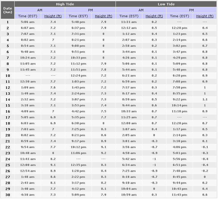

7 Page 7 June 2013

8 Page 8 July 2013

9 Page 9 August 2013

10 Page 10 September 2013

11 Page 11 October 2013

12 Page 12 November 2013


13 Page 13 December 2013
, the new or full moon coincides closely in time with the perigee of the moon the point when the moon is closest to the planet.")
14 Page 14 SPRING TIDES PERIGEE (means closet to the earth) and or PERIGEAN TIDES are the same! About three or four times a year (in the spring and the fall), the new or full moon coincides closely in time with the perigee of the moon the point when the moon is closest to the planet. These occurrences are often called 'perigean spring tides.' A spring tide is a common historical term that has nothing to do with the season of spring. Rather, the term is derived from the concept of the tide "springing forth." Spring tides occur twice each lunar month all year long without regard to the season. Neap tides ( Moderate Tides), which also occur twice a month, happen when the sun and moon are at right angles to each other. The following is a explanation of spring and neap tides in relation to lunar and solar cycles. Since antiquity, people have noticed that oceans exhibit a much greater tidal range around the time of the full Moon and new Moon. This is when the Moon and Sun are either together in the sky or are on opposite sides of the heavens. Higher tides occur during these Moon phases because the Sun also exerts a gravitational pull on our oceans, although it is only 46 percent as strong as the Moon's. When the gravitational effects of the Sun and the Moon combine, we get spring tides, which have nothing to do with the season of spring. The term refers to the action of the seas springing out and then springing back. These are times of high high tides and low low tides. A week later, during either of the two quarter Moon phases, when the Sun and Moon are at right angles to each other and their tidal influences partially cancel each other out, neap tides occur, and the tidal range is minimal. In fact, because the oceans take a bit of time to catch up to the geometry of the Moon, spring and neap tides usually occur about a day after the respective lunar cycles. Bob Berman For the year 2013 these are the Perigee tide dates: Jan 10, Feb 7, Mar 5, Mar 31, Apr 27, May 26, Jun 23, Jul 21, Aug 19, Sep 15, Oct 10, Oct 25, Nov 6, Dec 4, Source: Q: What is the difference between "Tide Charts" and "Tide Tables"? "Tide Charts" and "Tide Tables" are actually two different products. "Tide Charts" refer to a series of maps that show the water levels throughout a bay or estuary at a particular point in time. These maps normally show the water levels on an hourly basis after high tide. "Tide Charts" are only available for a few locations around the USA.


15 Please Support Our Advertisers Page 9 Nor Easters Metal Detecting Club PO BOX 2232 STAMFORD, CT Jessie Thompson - mrmetaldetector@noreasters.net We are on the web at Please deliver to:
SOUTH AFRICAN TIDE TABLES
 SAN HO-2 2018 SOUTH AFRICAN TIDE TABLES PUBLISHED BY THE HYDROGRAPHER SOUTH AFRICAN NAVY PRIVATE BAG X1 TOKAI, 7966 COPYRIGHT RESERVED ISBN 978-0-9869717-9-2 CONTENTS Preface.... (iii) Tidal Levels......(iv)
SOUTH AFRICAN TIDE TABLES
 SAN HO-2 2019 SOUTH AFRICAN TIDE TABLES PUBLISHED BY THE HYDROGRAPHER SOUTH AFRICAN NAVY PRIVATE BAG X1 TOKAI, 7966 COPYRIGHT RESERVED ISBN 978-0-9947002-0-9 Intentionally left blank CONTENTS Preface....
1. The diagram below represents Earth and the Moon as viewed from above the North Pole. Points A, B, C, and D are locations on Earth's surface.
 1. The diagram below represents Earth and the Moon as viewed from above the North Pole. Points A, B, C, and D are locations on Earth's surface. 2. The graph below shows the change in tide heights of the
Moon Occurrences. Eclipses. Tides
 Moon Occurrences Eclipses Tides Notes page: What is an eclipse? An eclipse is an event during which one object casts a shadow onto another. Two types of Eclipses Two types of Eclipses: Lunar Eclipse Solar
WHEN IS IT EVER GOING TO RAIN? Table of Average Annual Rainfall and Rainfall For Selected Arizona Cities
 WHEN IS IT EVER GOING TO RAIN? Table of Average Annual Rainfall and 2001-2002 Rainfall For Selected Arizona Cities Phoenix Tucson Flagstaff Avg. 2001-2002 Avg. 2001-2002 Avg. 2001-2002 October 0.7 0.0
Drought in Southeast Colorado
 Drought in Southeast Colorado Nolan Doesken and Roger Pielke, Sr. Colorado Climate Center Prepared by Tara Green and Odie Bliss http://climate.atmos.colostate.edu 1 Historical Perspective on Drought Tourism
Moon Occurrences. Eclipses. Tides
 Moon Occurrences Eclipses Tides Notes page: What is an eclipse? An eclipse is an event during which one object casts a shadow onto another. Two types of Eclipses Two types of Eclipses: Lunar Eclipse Solar
The Giant Tides of Fundy What are tides?
 The Giant Tides of Fundy What are tides? The tide is the natural change in elevation of water over time and can easily be observed along any ocean coastline. Some areas of the world have one high tide
Exemplar for Internal Achievement Standard Science Level 1. Demonstrate understanding of the effects of astronomical cycles on planet Earth.
 Exemplar for Internal Achievement Standard Science Level 1 This exemplar supports assessment against: Achievement Standard 90954 Demonstrate understanding of the effects of astronomical cycles on planet
Location. Datum. Survey. information. Etrometa. Step Gauge. Description. relative to Herne Bay is -2.72m. The site new level.
 Tide Gauge Location OS: 616895E 169377N WGS84: Latitude: 51 o 22.919196 N Longitude: 01 o 6.9335907 E Instrument Type Etrometa Step Gauge Benchmarks Benchmark TGBM = 5.524m above Ordnance Datum Newlyn
UNDERSTANDING STORM TIDES
 UNDERSTANDING STORM TIDES Run from the water, hide from the wind.. CATEGORY CATEGORY CATEGORY CATEGORY CATEGORY 1 2 3 4 5 WIND 74-95 mph 64-82 knots 96-110 mph 83-95 knots 111-130 mph 96-113 knots 131-155
Location. Datum. Survey. information. Etrometa. Step Gauge. Description. relative to Herne Bay is -2.72m. The site new level.
 Tide Gauge Location OS: 616895E 169377N WGS84: Latitude: 51 o 22.919196 N Longitude: 01 o 6.9335907 E Instrument Type Etrometa Step Gauge Benchmarks Benchmark TGBM = 5.524m above Ordnance Datum Newlyn
Determine the trend for time series data
 Extra Online Questions Determine the trend for time series data Covers AS 90641 (Statistics and Modelling 3.1) Scholarship Statistics and Modelling Chapter 1 Essent ial exam notes Time series 1. The value
Page Tides ANIMATION. Tidal forces
 Page 194 7.5 Tides ANIMATION Tidal forces Anyone who has spent even a few hours by the sea knows that the ocean's level rises and falls during the day. A blanket set on the sand 10 feet from the water's
Champaign-Urbana 2001 Annual Weather Summary
 Champaign-Urbana 2001 Annual Weather Summary ILLINOIS STATE WATER SURVEY 2204 Griffith Dr. Champaign, IL 61820 wxobsrvr@sws.uiuc.edu Maria Peters, Weather Observer January: After a cold and snowy December,
8.1 Attachment 1: Ambient Weather Conditions at Jervoise Bay, Cockburn Sound
 8.1 Attachment 1: Ambient Weather Conditions at Jervoise Bay, Cockburn Sound Cockburn Sound is 20km south of the Perth-Fremantle area and has two features that are unique along Perth s metropolitan coast
The SMILE Program August Teachers Workshop, 2004 Tracking Tides Tracking the Tides
 Tracking the Tides Tides are the periodic rise and fall of the ocean waters. They are caused by the gravitational pulls of the moon and (to a lesser extent) sun, as well as the rotation of the Earth. The
MS 20 Tides Exercise
 MS 20 Tides Exercise Name Time class meets Introduction Tides are the cyclical rise and fall of sea level caused by the gravitational attraction of the moon and, to a lesser extent, by the sun. Gravitational
Scarborough Tide Gauge
 Tide Gauge Location OS: 504898E 488622N WGS84: Latitude: 54 16' 56.990"N Longitude: 00 23' 25.0279"W Instrument Valeport 740 (Druck Pressure Transducer) Benchmarks Benchmark Description TGBM = 4.18m above
Tides The Largest Waves in the Ocean
 Tides Tides The Largest Waves in the Ocean Understanding Tides Understanding Tides You will study several topics: Why Earth has tides Why tides vary daily Why tides vary monthly Tide Generation Tide Generation
Agricultural Science Climatology Semester 2, Anne Green / Richard Thompson
 Agricultural Science Climatology Semester 2, 2006 Anne Green / Richard Thompson http://www.physics.usyd.edu.au/ag/agschome.htm Course Coordinator: Mike Wheatland Course Goals Evaluate & interpret information,
The Climate of Bryan County
 The Climate of Bryan County Bryan County is part of the Crosstimbers throughout most of the county. The extreme eastern portions of Bryan County are part of the Cypress Swamp and Forest. Average annual
Lunar Tidal Effects on the Bottom Side of the Ionospheric Plasma With Variation of Local Magnetic Field in Mid-Latitude
 Lunar Tidal Effects on the Bottom Side of the Ionospheric Plasma With Variation of Local Magnetic Field in Mid-Latitude Leili Ebrahimi Razgale 1, Zahra Emami 1*, Mahdi Bakhshi 2, Mina Janserian 1 1 Department
A) M D) The Moon s distance from Earth varies in a cyclic manner.
 M D) The Moon s distance from Earth varies in a cyclic manner.") Base your answers to questions 1 and 2 on the diagram below, which shows Earth in orbit around the Sun, and the Moon in orbit around Earth. M 1, M 2, M 3, and M 4 indicate positions of the Moon in its
Base your answers to questions 1 and 2 on the diagram below, which shows Earth in orbit around the Sun, and the Moon in orbit around Earth. M 1, M 2, M 3, and M 4 indicate positions of the Moon in its
Homeroom: OBJECTIVES: By the end of today s lesson, you will be able to. SWBAT explain how the gravity of the moon causes tides in Earth s oceans.
 7 th Grade Science Unit: Earth, Sun, and Moon Lesson: ESM 9_ Tides 1 Name: Date: Thursday, October 27, 2016 Homeroom: OBJECTIVES: By the end of today s lesson, you will be able to SWBAT explain how the
Sun Moon Earth connections. Phases Eclipses Tides
 Moon FACTS The Moon is a natural Satellite that revolves around the Earth The Moon is made of rock The Moon is 382,400 kilometers 250,000miles from Earth The moon is about ¼ the size of Earth The moon
The Climate of Payne County
 The Climate of Payne County Payne County is part of the Central Great Plains in the west, encompassing some of the best agricultural land in Oklahoma. Payne County is also part of the Crosstimbers in the
u.s. Naval Observatory Astronomical Applications Department
 Phases ofthe Moon Page 1 of 1 u.s. Naval Observatory Astronomical Applications Department Phases of the Moon 1944 Phases of the Moon Universal Time New Moon First Quarter Full Moon Last Quarter d h m d
Exemplar for Internal Achievement Standard. Mathematics and Statistics Level 3
 Exemplar for internal assessment resource Mathematics and Statistics for Achievement Standard 91580 Exemplar for Internal Achievement Standard Mathematics and Statistics Level 3 This exemplar supports
GAMINGRE 8/1/ of 7
 FYE 09/30/92 JULY 92 0.00 254,550.00 0.00 0 0 0 0 0 0 0 0 0 254,550.00 0.00 0.00 0.00 0.00 254,550.00 AUG 10,616,710.31 5,299.95 845,656.83 84,565.68 61,084.86 23,480.82 339,734.73 135,893.89 67,946.95
Drought Characterization. Examination of Extreme Precipitation Events
 Drought Characterization Examination of Extreme Precipitation Events Extreme Precipitation Events During the Drought For the drought years (1999-2005) daily precipitation data was analyzed to find extreme
PRELIMINARY DRAFT FOR DISCUSSION PURPOSES
 Memorandum To: David Thompson From: John Haapala CC: Dan McDonald Bob Montgomery Date: February 24, 2003 File #: 1003551 Re: Lake Wenatchee Historic Water Levels, Operation Model, and Flood Operation This
LAB 3: THE SUN AND CLIMATE NAME: LAB PARTNER(S):
:") GEOG 101L PHYSICAL GEOGRAPHY LAB SAN DIEGO CITY COLLEGE SELKIN 1 LAB 3: THE SUN AND CLIMATE NAME: LAB PARTNER(S): The main objective of today s lab is for you to be able to visualize the sun s position
GEOG 101L PHYSICAL GEOGRAPHY LAB SAN DIEGO CITY COLLEGE SELKIN 1 LAB 3: THE SUN AND CLIMATE NAME: LAB PARTNER(S): The main objective of today s lab is for you to be able to visualize the sun s position
Colorado s 2003 Moisture Outlook
 Colorado s 2003 Moisture Outlook Nolan Doesken and Roger Pielke, Sr. Colorado Climate Center Prepared by Tara Green and Odie Bliss http://climate.atmos.colostate.edu How we got into this drought! Fort
Analysis of Historical Pattern of Rainfall in the Western Region of Bangladesh
 24 25 April 214, Asian University for Women, Bangladesh Analysis of Historical Pattern of Rainfall in the Western Region of Bangladesh Md. Tanvir Alam 1*, Tanni Sarker 2 1,2 Department of Civil Engineering,
The Climate of Grady County
 The Climate of Grady County Grady County is part of the Central Great Plains, encompassing some of the best agricultural land in Oklahoma. Average annual precipitation ranges from about 33 inches in northern
Weather and Climate of the Rogue Valley By Gregory V. Jones, Ph.D., Southern Oregon University
 Weather and Climate of the Rogue Valley By Gregory V. Jones, Ph.D., Southern Oregon University The Rogue Valley region is one of many intermountain valley areas along the west coast of the United States.
Changing Hydrology under a Changing Climate for a Coastal Plain Watershed
 Changing Hydrology under a Changing Climate for a Coastal Plain Watershed David Bosch USDA-ARS, Tifton, GA Jeff Arnold ARS Temple, TX and Peter Allen Baylor University, TX SEWRU Objectives 1. Project changes
Variability and trends in daily minimum and maximum temperatures and in diurnal temperature range in Lithuania, Latvia and Estonia
 Variability and trends in daily minimum and maximum temperatures and in diurnal temperature range in Lithuania, Latvia and Estonia Jaak Jaagus Dept. of Geography, University of Tartu Agrita Briede Dept.
The Climate of Kiowa County
 The Climate of Kiowa County Kiowa County is part of the Central Great Plains, encompassing some of the best agricultural land in Oklahoma. Average annual precipitation ranges from about 24 inches in northwestern
Tornado Hazard Risk Analysis: A Report for Rutherford County Emergency Management Agency
 Tornado Hazard Risk Analysis: A Report for Rutherford County Emergency Management Agency by Middle Tennessee State University Faculty Lisa Bloomer, Curtis Church, James Henry, Ahmad Khansari, Tom Nolan,
Champaign-Urbana 2000 Annual Weather Summary
 Champaign-Urbana 2000 Annual Weather Summary ILLINOIS STATE WATER SURVEY 2204 Griffith Dr. Champaign, IL 61820 wxobsrvr@sws.uiuc.edu Maria Peters, Weather Observer January: January started on a mild note,
SKYCAL - Sky Events Calendar
 SKYCAL - Sky Events Calendar Your web browser must have Javascript turned on. The following browsers have been successfully tested: Macintosh - Firefox 3.0 (Safari NOT supported) Windows - Firefox 3.0,
The Climate of Marshall County
 The Climate of Marshall County Marshall County is part of the Crosstimbers. This region is a transition region from the Central Great Plains to the more irregular terrain of southeastern Oklahoma. Average
The Climate of Haskell County
 The Climate of Haskell County Haskell County is part of the Hardwood Forest. The Hardwood Forest is characterized by its irregular landscape and the largest lake in Oklahoma, Lake Eufaula. Average annual
2003 Water Year Wrap-Up and Look Ahead
 2003 Water Year Wrap-Up and Look Ahead Nolan Doesken Colorado Climate Center Prepared by Odie Bliss http://ccc.atmos.colostate.edu Colorado Average Annual Precipitation Map South Platte Average Precipitation
The Climate of Texas County
 The Climate of Texas County Texas County is part of the Western High Plains in the north and west and the Southwestern Tablelands in the east. The Western High Plains are characterized by abundant cropland
2019 Settlement Calendar for ASX Cash Market Products. ASX Settlement
 2019 Settlement Calendar for ASX Cash Market Products ASX Settlement Settlement Calendar for ASX Cash Market Products 1 ASX Settlement Pty Limited (ASX Settlement) operates a trade date plus two Business
Highlights of the 2006 Water Year in Colorado
 Highlights of the 2006 Water Year in Colorado Nolan Doesken, State Climatologist Atmospheric Science Department Colorado State University http://ccc.atmos.colostate.edu Presented to 61 st Annual Meeting
Jackson County 2013 Weather Data
 Jackson County 2013 Weather Data 61 Years of Weather Data Recorded at the UF/IFAS Marianna North Florida Research and Education Center Doug Mayo Jackson County Extension Director 1952-2008 Rainfall Data
Earth s Motion. Lesson Outline LESSON 1. A. Earth and the Sun 1. The diameter is more than 100 times greater than
 Lesson Outline Earth s Motion LESSON 1 A. Earth and the Sun 1. The diameter is more than 100 times greater than Earth s diameter. a. In the Sun, atoms combine during, producing huge amounts of energy.
Physical Science. Chapter 22 The Earth in Space. Earth s Rotation
 Physical Science Chapter 22 The Earth in Space Earth s Rotation Axis imaginary line passing through the North and South Pole Earth s axis is tilted at 23 ½ degrees Rotation: the Earth spinning on its axis
Calculations Equation of Time. EQUATION OF TIME = apparent solar time - mean solar time
 Calculations Equation of Time APPARENT SOLAR TIME is the time that is shown on sundials. A MEAN SOLAR DAY is a constant 24 hours every day of the year. Apparent solar days are measured from noon one day
Physical Science. Chapter 22 The Earth in Space
 Physical Science Chapter 22 The Earth in Space Earth s Rotation Axis imaginary line passing through the North and South Pole Earth s axis is tilted at 23 ½ degrees Rotation: the Earth spinning on its axis
The Climate of Pontotoc County
 The Climate of Pontotoc County Pontotoc County is part of the Crosstimbers. This region is a transition region from the Central Great Plains to the more irregular terrain of southeast Oklahoma. Average
Memo. I. Executive Summary. II. ALERT Data Source. III. General System-Wide Reporting Summary. Date: January 26, 2009 To: From: Subject:
 Memo Date: January 26, 2009 To: From: Subject: Kevin Stewart Markus Ritsch 2010 Annual Legacy ALERT Data Analysis Summary Report I. Executive Summary The Urban Drainage and Flood Control District (District)
WIND DATA REPORT FOR THE YAKUTAT JULY 2004 APRIL 2005
 WIND DATA REPORT FOR THE YAKUTAT JULY 2004 APRIL 2005 Prepared on July 12, 2005 For Bob Lynette 212 Jamestown Beach Lane Sequim WA 98382 By John Wade Wind Consultant LLC 2575 NE 32 nd Ave Portland OR 97212
Chapter 10: Tides. Tides: 1. Understanding the Earth-Moon system
 Chapter 10: Tides Remember that tides are waves that are caused by the gravitational attraction of moon and sun. Tidal waves are the longest of all waves, L can be up to half the Earth s circumference.
2003 Moisture Outlook
 2003 Moisture Outlook Nolan Doesken and Roger Pielke, Sr. Colorado Climate Center Prepared by Tara Green and Odie Bliss http://climate.atmos.colostate.edu Through 1999 Through 1999 Fort Collins Total Water
PHASES, ECLIPSES, AND TIDES
 PHASES, ECLIPSES, AND TIDES MOTIONS OF THE MOON The changing relative positions of the moon, Earth, and sun cause the phases of the moon, eclipses, and tides. The moon rotates once on its axis in the same
2018 Annual Review of Availability Assessment Hours
 2018 Annual Review of Availability Assessment Hours Amber Motley Manager, Short Term Forecasting Clyde Loutan Principal, Renewable Energy Integration Karl Meeusen Senior Advisor, Infrastructure & Regulatory
Earth in Space. The Sun-Earth-Moon System
 in Space The --Moon System What do you think? Read the two statements below and decide whether you agree or disagree with them. Place an A in the Before column if you agree with the statement or a D if
The Climate of Seminole County
 The Climate of Seminole County Seminole County is part of the Crosstimbers. This region is a transition region from the Central Great Plains to the more irregular terrain of southeastern Oklahoma. Average
The Climate of Murray County
 The Climate of Murray County Murray County is part of the Crosstimbers. This region is a transition between prairies and the mountains of southeastern Oklahoma. Average annual precipitation ranges from
1. The pictures below show the Sun at midday. Write winter, spring or summer under the correct picture.
 Test 2 1. The pictures below show the Sun at midday. Write winter, spring or summer under the correct picture. 2. Look carefully at the phases of the Moon. Number them (1 to 4) in the order that you would
Chiang Rai Province CC Threat overview AAS1109 Mekong ARCC
 Chiang Rai Province CC Threat overview AAS1109 Mekong ARCC This threat overview relies on projections of future climate change in the Mekong Basin for the period 2045-2069 compared to a baseline of 1980-2005.
STATISTICAL FORECASTING and SEASONALITY (M. E. Ippolito; )
") STATISTICAL FORECASTING and SEASONALITY (M. E. Ippolito; 10-6-13) PART I OVERVIEW The following discussion expands upon exponential smoothing and seasonality as presented in Chapter 11, Forecasting, in
STATISTICAL FORECASTING and SEASONALITY (M. E. Ippolito; 10-6-13) PART I OVERVIEW The following discussion expands upon exponential smoothing and seasonality as presented in Chapter 11, Forecasting, in
Mars Opposition Friday 27 th July 2018
 Mars Opposition Friday 27 th July 2018 Mars is about 6,780 kilometres in diameter or roughly half the size of the Earth whose diameter is 12,742km. As they orbit the Sun, the minimum distance between the
Guided Notes Astronomy. Earth s Moon Formation Orbit Craters Motions Phases Tides Eclipses
 Guided Notes Astronomy Earth s Moon Formation Orbit Craters Motions Phases Tides Eclipses K. Coder 2015 1. What is the Moon? The Moon: the Earth's only natural satellite. See ESRT page 15 for data on Earth
(All times listed are UT); Singapore Standard (Local) Time = UT + 8 h
; Singapore Standard (Local) Time = UT + 8 h") SKYTRACK Diary of Astronomical Events 2011 (All times listed are UT); Singapore Standard (Local) Time = UT + 8 h January 02 15 Mercury 4º N of Moon 04 09 NEW MOOM (Partial Solar Eclipse not visible from
SKYTRACK Diary of Astronomical Events 2011 (All times listed are UT); Singapore Standard (Local) Time = UT + 8 h January 02 15 Mercury 4º N of Moon 04 09 NEW MOOM (Partial Solar Eclipse not visible from
What causes the tides in the ocean?
 What causes the tides in the ocean? By NASA and NOAA, adapted by Newsela staff on 02.09.17 Word Count 686 Level 830L Flying gulls on Morro Strand State Beach, California, at low tide. Morro Rock is seen
Published by ASX Settlement Pty Limited A.B.N Settlement Calendar for ASX Cash Market Products
 Published by Pty Limited A.B.N. 49 008 504 532 2012 Calendar for Cash Market Products Calendar for Cash Market Products¹ Pty Limited ( ) operates a trade date plus three Business (T+3) settlement discipline
UWM Field Station meteorological data
 University of Wisconsin Milwaukee UWM Digital Commons Field Station Bulletins UWM Field Station Spring 992 UWM Field Station meteorological data James W. Popp University of Wisconsin - Milwaukee Follow
Astrological Calendar. for Central Time
 2014 for Central Time January 2014 Capricorn Compliments of: Clayten Tylor Esoteric Astrologer (604)331-0251 Jan 15, 2014 Full Moon 10:53:09 PM CST Jan 1, 2014 New Moon 05:15:21 AM CST January 2014 Sun
Overview: In this activity, students will learn how the moon affects ocean tides and also will create and interpret graphs of regional tide data.
 Tides & Lunar Cycles Overview: In this activity, students will learn how the moon affects ocean tides and also will create and interpret graphs of regional tide data. Episode Connection: Tides At the conclusion
Complete the body of your
 Complete the body of your notes All blanks filled in All vocabulary words highlighted All pictures drawn with at least 3 labels each. Revise in pen. Review your notes and write the questions. Write the
astronomy A planet was viewed from Earth for several hours. The diagrams below represent the appearance of the planet at four different times.
 astronomy 2008 1. A planet was viewed from Earth for several hours. The diagrams below represent the appearance of the planet at four different times. 5. If the distance between the Earth and the Sun were
Chapter 10 Tides. Introductory Oceanography 10 th Edition
 Chapter 10 Tides Introductory Oceanography 10 th Edition Most ocean waves are wind-generated The medium itself (solid, liquid, gas) does NOT actually travel in the direction of energy Figure 8-2 What causes
2017 Settlement Calendar for ASX Cash Market Products ASX SETTLEMENT
 2017 Settlement Calendar for ASX Cash Market Products ASX SETTLEMENT Settlement Calendar for ASX Cash Market Products 1 ASX Settlement Pty Limited (ASX Settlement) operates a trade date plus two Business
TILT, DAYLIGHT AND SEASONS WORKSHEET
 TILT, DAYLIGHT AND SEASONS WORKSHEET Activity Description: Students will use a data table to make a graph for the length of day and average high temperature in Utah. They will then answer questions based
Champaign-Urbana 1999 Annual Weather Summary
 Champaign-Urbana 1999 Annual Weather Summary ILLINOIS STATE WATER SURVEY 2204 Griffith Dr. Champaign, IL 61820 wxobsrvr@sws.uiuc.edu Maria Peters, Weather Observer A major snowstorm kicked off the new
CIMA Professional
 CIMA Professional 201819 Birmingham Interactive Timetable Version 3.1 Information last updated 12/10/18 Please note: Information and dates in this timetable are subject to change. A better way of learning
CIMA Professional
 CIMA Professional 201819 Manchester Interactive Timetable Version 3.1 Information last updated 12/10/18 Please note: Information and dates in this timetable are subject to change. A better way of learning
UPDATE OF REGIONAL WEATHER AND SMOKE HAZE (December 2017)
") UPDATE OF REGIONAL WEATHER AND SMOKE HAZE (December 2017) 1. Review of Regional Weather Conditions for November 2017 1.1 In November 2017, Southeast Asia experienced inter-monsoon conditions in the first
UPDATE OF REGIONAL WEATHER AND SMOKE HAZE (December 2017) 1. Review of Regional Weather Conditions for November 2017 1.1 In November 2017, Southeast Asia experienced inter-monsoon conditions in the first
SC.8.E.5.9. Summer and Winter Gizmo
 8 th Grade Science Quarter 1 Recovery Packet SC.8.E.5.9 DAYS/YEARS/SEASONS Go to www.explorelearning.com and search for the Summer and Winter Gizmo. Answer the following questions: Gizmo Warm-up Summer
Monthly Long Range Weather Commentary Issued: NOVEMBER 16, 2015 Steven A. Root, CCM, Chief Analytics Officer, Sr. VP, sales
 Monthly Long Range Weather Commentary Issued: NOVEMBER 16, 2015 Steven A. Root, CCM, Chief Analytics Officer, Sr. VP, sales sroot@weatherbank.com OCTOBER 2015 Climate Highlights The Month in Review The
Local Ctimatotogical Data Summary White Hall, Illinois
 SWS Miscellaneous Publication 98-5 STATE OF ILLINOIS DEPARTMENT OF ENERGY AND NATURAL RESOURCES Local Ctimatotogical Data Summary White Hall, Illinois 1901-1990 by Audrey A. Bryan and Wayne Armstrong Illinois
DOZENALS. A project promoting base 12 counting and measuring. Ideas and designs by DSA member (#342) and board member, Timothy F. Travis.
 and board member, Timothy F. Travis.") R AENBO DOZENALS A project promoting base 12 counting and measuring. Ideas and designs by DSA member (#342) and board member Timothy F. Travis. I became aware as a teenager of base twelve numbering from
R AENBO DOZENALS A project promoting base 12 counting and measuring. Ideas and designs by DSA member (#342) and board member Timothy F. Travis. I became aware as a teenager of base twelve numbering from
ASTRONOMY Merit Badge Requirements
 ASTRONOMY Merit Badge Requirements 1) Do the following: A) Sketch the face of the moon, indicating on it the locations of at least five seas and five craters. B) Within a single week, sketch the position
GLNG PROJECT - ENVIRONMENTAL IMPACT STATEMENT
 8 Management of Impacts J:\Jobs\42626220\07 Deliverables\EIS\FINAL for Public Release\8. Management of Impacts\8-2 Climate\08 02 Climate (Section 8.2) FINAL Public.doc GLNG Project - Environmental Impact
Explained by Dr CJC Rees (York)
") HOW THE TIDES WORK Explained by Dr CJC Rees (York) TIDES AND WATER MARKS TIDES and the - SYSTEM The earth-moon system rotates in space about its common centre of mass, there being a stabilising balance
HOW THE TIDES WORK Explained by Dr CJC Rees (York) TIDES AND WATER MARKS TIDES and the - SYSTEM The earth-moon system rotates in space about its common centre of mass, there being a stabilising balance
Term Info Picture. A celestial body that orbits a bigger celestial body (a moon) Earth s only natural satellite. It causes all of the tides.
 Earth s only natural satellite. It causes all of the tides.") Astronomy (Earth, Moon and Sun) S6E2. Obtain, evaluate, and communicate information about the effets of the relative positions of the sun, Earth and moon. A. Develop and use a model to demonstrate the
Astronomy (Earth, Moon and Sun) S6E2. Obtain, evaluate, and communicate information about the effets of the relative positions of the sun, Earth and moon. A. Develop and use a model to demonstrate the
PROGRESS ACCOMPLISHED THIS PERIOD
 Semi-Annual Report Period Covered: September 1, 21 through February 28, 217 Prepared By: Richard Radigan Title: Monitoring of a Constructed Oyster Reef in the St. Lucie Estuary Agency: Florida Fish & Wildlife
Lecture Prepared By: Mohammad Kamrul Arefin Lecturer, School of Business, North South University
 Lecture 15 20 Prepared By: Mohammad Kamrul Arefin Lecturer, School of Business, North South University Modeling for Time Series Forecasting Forecasting is a necessary input to planning, whether in business,
What is happening to the Jamaican climate?
 What is happening to the Jamaican climate? Climate Change and Jamaica: Why worry? Climate Studies Group, Mona (CSGM) Department of Physics University of the West Indies, Mona Part 1 RAIN A FALL, BUT DUTTY
A. the spinning of Earth on its axis B. the path of the Sun around Earth
 stronomy 1 Packet Write answers on your own paper 1. The Sun appears to move across the sky each day. What causes this?. the spinning of Earth on its axis. the path of the Sun around Earth. the production
Monthly Long Range Weather Commentary Issued: February 15, 2015 Steven A. Root, CCM, President/CEO
 Monthly Long Range Weather Commentary Issued: February 15, 2015 Steven A. Root, CCM, President/CEO sroot@weatherbank.com JANUARY 2015 Climate Highlights The Month in Review During January, the average
2016 Meteorology Summary
 2016 Meteorology Summary New Jersey Department of Environmental Protection AIR POLLUTION AND METEOROLOGY Meteorology plays an important role in the distribution of pollution throughout the troposphere,
DAILY QUESTIONS 28 TH JUNE 18 REASONING - CALENDAR
 DAILY QUESTIONS 28 TH JUNE 18 REASONING - CALENDAR LEAP AND NON-LEAP YEAR *A non-leap year has 365 days whereas a leap year has 366 days. (as February has 29 days). *Every year which is divisible by 4
TIDAL POWER!
 Tide Notes terms: spring tide, neap tide, flood tide,ebb tide, slack tide, mean low water, mean high water, sea level, diurnal tides, semidiurnal tides http://www.iit.edu/~johnsonp/smart00/lesson4.htm#highest