Case Study: Modeling the Bundaberg Floods. Sudesh Mudaliar, VP Asia Pacific Anthony Kuch, VP North America
|
|
|
- Clifton Gilmore
- 6 years ago
- Views:
Transcription


1 Case Study: Modeling the Bundaberg Floods Sudesh Mudaliar, VP Asia Pacific Anthony Kuch, VP North America
2 Bundaberg Case Study Burnett River Flood Events Flood Damage Impacts Surveying & LiDAR Current 2D Modelling & Applications Disaster Management Modelling Acknowledgements Bundaberg Regional Council GHD Bureau of Meteorology ROAMES

3 Bundaberg Region QLD Population: 98,000 Projected 2031: 130,000 Area: 6,500 km 2 Asset Value: $2.09 Billion Annual Budget: $206M
4 River Systems Significant number of sub basin outlets Burnett River Kolan River Elliot River Isis River Gregory River Burrum River Baffle Creek Paradise Dam
5 Historical Flood Events
6 Burnett River Weeks of widespread rain on the Burnett catchment (33,248 km 2 ) December , peaked at 7.92 m, largest since 1942 Region was disaster declared, emergency crews activated 13 th Jan 2011 the flood returned

7 26 th January Tornadoes touched down on the coast By evening, torrential rain falling on the Burnett River catchment Flood Emergency Alerts Issued for Kolan River & Baffle Creek 1m Storm Surge predicted Ex Tropical Cyclone Oswald tracked inland of Bundaberg

8 Bundaberg
9 New Meteorological Records Burnett Catchment Rainfall Average of millimetres for 27 January exceeded the previous record (123.6 millimetres) by nearly 70 per cent!! Rainfall Totals Highest records set for 2, 3 and 4 day timescales by large margins Extreme daily rainfall across the catchment Walla TM 480mm (500yr rain event) Mt Rawdon 549mm Bundaberg AP 252mm Gold Coast Hinterland >700mm daily rainfall!
10 27 th January 2013 Burnett River Bundaberg 6:30am 4:00pm BoM advised 8.5m overnight with higher peak expected Commenced Voluntary Mass Evacuation of North & East Bundaberg Swift Water Rescue operating
11 28 th January :45am Burnett River exceeded 8.5m (>7m is serious) and rising! Mandatory evacuations of North Bundaberg Largest in QLD s history... 4 ADF blackhawks,4 Careflight, 2 AGL Rescue and 1 SLSQ helicopters Conservatively 5,500 in Nth Bundaberg, over 7,000 in the greater area At the peak approx 1,400 at evacuation centres


12 North Bundaberg Twitter: Commander Chris Hadfield International Space Station
13 29 th January 2013 Burnett River peaks at 9.53m at 3:15pm (0.5% AEP event 9.6m)


14 2013 Damage


15 Relocation due to Buoyancy 410m


16 Scour Holes

17 Scour Depths up to 2.5m

18 Flood Surveying Can t Manage what you don t Measure Opportunity to capture data: Flood Model Calibration Event Prediction Disaster Management Town Planning Controls

19 LiDAR Coverage Over 4000 km 2 Field Spatial Accuracy (Hz) metres Spatial Accuracy (Vt) metres Average Point Separation Description 67 % CI 67 % CI 67 % CI 1 4 pnt/m^2 Data Tile size (km 2 ) 1 4 km 2
20 Over 65,000km2 across QLD Data is classified: Ground (XYZ Ascii, Grid) Water Bare Earth Above Ground Classified LAS (Buildings etc) LiDAR Coverage

21 Roughness Map Nested 2D Model
22 2D Modelling Importance Represent Complex flood behaviour up to PMF events: Breakouts, bypasses and backwaters important for overtopping Flow characteristics such as level, depth, velocity, hazard and shear stress. 1D fails to distinguish spatial variation High quality spatial datasets
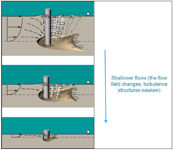
23 2D Modelling & Scour Scour is the loss of soil by erosion due to water flow. General scour is the aggradation or degradation of sediment material not related to the presence of local flow obstacles. Local Scour is a term frequently used to describe the scour around obstacles that results from increased local flow velocities (flow acceleration). It includes pier scour, abutment scour, and contraction scour.


24 Shear Stress Flow force per unit ground area

25 Local 2D Hydraulic Model: Velocity Vectors & Shear Stress Map

26 Structural Damage to Footings


27 Guideline for Improved Dwelling Resilience to Flood Induced Scour
28 Model Outputs River flows, flood levels, river velocities and hazard indices for defined flood events to PMF Map the subject areas: Urban areas flood level contour (0.1 m) Non urban areas flood level contour (0.25 m) Hazard, Depth, Velocity, Time to Peak,


29


30
31 Emergency Management Maps Assessment of evacuation routes, population at risk investigations, time of inundation and duration ofinundation, and flood damages estimation. 2D Model generates a series of flood surfaces for a range of flow rates or Gauge Heights
 Bundaberg Flood")
32 January, 2013 Event (Calibrated Flood Model vs Actual) Bundaberg Flood Gauge
33 Key Learnings Model the full range of events, don t just consider planning instruments Where possible undertake 2D Modelling on entire catchment, especially where rural residential exists. Understand the relationship between flood levels and river gauges, especially for population density; Ensure the spatial data is key deliverable of any flood study; Undertake Floor Level Surveys for residential dwellings it saves lives Incremental flood maps tied to river gauges (not Design Events) are essential during emergencies
Floodplain Risk Management in Dungog after the April 2015 Super Storm. Presentation Outline
 Presentation Outline Floodplain Risk Management in after the April 2015 Super Storm Rohan Hudson, Royal HaskoningDHV FMA 2017 Preparing for the Next Great Flood 17th May 2017 Background and Flood Mechanisms
Meeting the New Queensland Coastal Plan Storm Surge Requirements for Redland City Council. Queensland Coastal Conference 2011
 Meeting the New Queensland Coastal Plan Storm Surge Requirements for Redland City Council Ancient Knowledge Contemporary Innovation The Pullman Reef Hotel, Cairns Daniel Niven 1 and David Taylor 2 1 Cardno
Tropical Cyclone Oswald Coastal Monitoring
 Tropical Cyclone Oswald Coastal Monitoring Kieran Harper and John Maher Coastal Impacts Unit, Queensland Department of Science, Information Technology, Innovation and the Arts (DSITIA). 27 Quinlan St Deagon,
New design rainfalls. Janice Green, Project Director IFD Revision Project, Bureau of Meteorology
 New design rainfalls Janice Green, Project Director IFD Revision Project, Bureau of Meteorology Design Rainfalls Design Rainfalls Severe weather thresholds Flood forecasting assessing probability of rainfalls
RADAR Rainfall Calibration of Flood Models The Future for Catchment Hydrology? A Case Study of the Stanley River catchment in Moreton Bay, Qld
 RADAR Rainfall Calibration of Flood Models The Future for Catchment Hydrology? A Case Study of the Stanley River catchment in Moreton Bay, Qld A 1 Principal Engineer, Water Technology Pty Ltd, Brisbane,
Floods. Floods COMMUNITY EMERGENCY RESPONSE TEAM FLOODS CONTENT INSTRUCTOR GUIDANCE
 Floods Floods Introduce this topic by explaining that floods are one of the most common hazards in the United States. A flood occurs any time a body of water rises to cover what is usually dry land. Display
COMMUNITY EMERGENCY RESPONSE TEAM FLOODS INTRODUCTION
 INTRODUCTION Floods are one of the most common hazards in the United States. A flood occurs any time a body of water rises to cover what is usually dry land. Flood effects can be local, impacting a neighborhood
A global slowdown of tropical-cyclone translation speed and implications for flooding
 A global slowdown of tropical-cyclone translation speed and implications for flooding Thomas Mortlock, Risk Frontiers As the Earth s atmosphere warms, the atmospheric circulation changes. These changes
Integrating Hydrologic and Storm Surge Models for Improved Flood Warning
 Integ Hydrologic and Storm Surge Models for Improved Flood Warning Leahy, C.P, Entel, M, Sooriyakumaran, S, and Warren, G Flood Warning Program Office, Bureau of Meteorology, Docklands, Victoria National
Tool 2.1.4: Inundation modelling of present day and future floods
 Impacts of Climate Change on Urban Infrastructure & the Built Environment A Toolbox Tool 2.1.4: Inundation modelling of present day and future floods Authors M. Duncan 1 and G. Smart 1 Affiliation 1 NIWA,
Identification of Erosion Potential in an Urban River in North Australia Using GIS and Hydrodynamic Model
 Identification of Erosion Potential in an Urban River in North Australia Using GIS and Hydrodynamic Model L Adair a and A Rahman b a Gold Coast City Council, Gold Coast, Australia b School of Engineering
GLNG PROJECT - ENVIRONMENTAL IMPACT STATEMENT
 6 J:\Jobs\4262622\7 Deliverables\EIS\FINAL for Public Release\6. Coal Seam Gas Field Environmental Values and \6-2 Climate\6 2 Climate (Section 6 2) FINAL PUBLIC.doc GLNG Project - Environmental Impact
Waipatiki Catchment Flood Hazard Analysis. June 2008 AM 08/04 HBRC Plan Number 4029
 Waipatiki Catchment Flood Hazard Analysis June 2008 AM 08/04 HBRC Plan Number 4029 Asset Management Group Technical Report ISSN 1174 3085 Engineering Section Waipatiki Catchment: Flood Hazard Analysis
Initiative. Country Risk Profile: papua new guinea. Better Risk Information for Smarter Investments PAPUA NEW GUINEA.
 Pacific Catastrophe Risk Assessment And Financing Initiative PAPUA NEW GUINEA September 211 Country Risk Profile: papua new is expected to incur, on average, 85 million USD per year in losses due to earthquakes
Floods Lecture #21 20
 Floods 20 Lecture #21 What Is a Flood? Def: high discharge event along a river! Due to heavy rain or snow-melt During a flood, a river:! Erodes channel o Deeper & wider! Overflows channel o Deposits sediment
Tropical Cyclones Modelling For Natural Disaster Risk Management
 Tropical Cyclones Modelling For Natural Disaster Risk Management Juan Savioli a, M. Britton b, S. Szylkarski a and Claus Pederson a a DHI Water and Environment, 2 Elliott Street, Suite 1a, QLD 4217 Surfers
The AIR Tropical Cyclone Model for India
 The AIR Tropical Cyclone Model for India Tropical cyclones have caused millions, and even billions, of dollars in damage in India. The growing number of properties on the coast, together with growing insurance
Estimating Probable Maximum Precipitation for Linau River Basin in Sarawak
 Estimating Probable Maximum Precipitation for Linau River Basin in Sarawak M. Hussain, S. Nadya and F.J. Chia Hydropower Development Division, Sarawak Energy Berhad, 93050, Kuching, Sarawak, Malaysia Date
Kentucky Weather Hazards: What is Your Risk?
 Kentucky Weather Hazards: What is Your Risk? Stuart A. Foster State Climatologist for Kentucky 2010 Kentucky Weather Conference Bowling Green, Kentucky January 16, 2010 Perspectives on Kentucky s Climate
Caribbean Early Warning System Workshop
 Caribbean Early Warning System Workshop Hamonization in Existing EWS April 14-16, 2016 Presenter: Shawn Boyce Caribbean Institute for Meteorology and Hydrology Husbands, St. James Barbados Background Between
GC Briefing. Weather Sentinel Hurricane Florence. Status at 5 PM EDT (21 UTC) Today (NHC) Discussion. September 13, 2018
 Today (NHC) Discussion. September 13, 2018") GC Briefing September 13, 2018 Weather Sentinel Hurricane Florence Tropical storm conditions have been reported for areas of North Carolina and will continue to spread inland to the west and south. Hurricane
GC Briefing September 13, 2018 Weather Sentinel Hurricane Florence Tropical storm conditions have been reported for areas of North Carolina and will continue to spread inland to the west and south. Hurricane
The AIR Tropical Cyclone Model for Mexico
 The AIR Tropical Cyclone Model for Mexico In September 214, Hurricane Odile made landfall near Cabo San Lucas, Mexico, as a Category 3 hurricane, then moved up the center of Baja California, bringing strong
FLOOD FORECAST MAPPING SANS MODELLING
 FLOOD FORECAST MAPPING SANS MODELLING C Smythe 1, G Newell 1, C Druery 2 1 Sunshine Coast Council, Nambour, QLD 2 WorleyParsons, Sydney, NSW Abstract The 2012 Queensland Floods Commission of Inquiry recommendations
Flash Flood Guidance System On-going Enhancements
 Flash Flood Guidance System On-going Enhancements Hydrologic Research Center, USA Technical Developer SAOFFG Steering Committee Meeting 1 10-12 July 2017 Jakarta, INDONESIA Theresa M. Modrick Hansen, PhD
Hydrological forecasting and decision making in Australia
 Hydrological forecasting and decision making in Australia Justin Robinson, Jeff Perkins and Bruce Quig Bureau of Meteorology, Australia The Bureau's Hydrological Forecasting Services Seasonal Forecasts
The last three sections of the main body of this report consist of:
 Threatened and Endangered Species Geological Hazards Floodplains Cultural Resources Hazardous Materials A Cost Analysis section that provides comparative conceptual-level costs follows the Environmental
CURRENT AND FUTURE TROPICAL CYCLONE RISK IN THE SOUTH PACIFIC
 CURRENT AND FUTURE TROPICAL CYCLONE RISK IN THE SOUTH PACIFIC COUNTRY RISK PROFILE: SAMOA JUNE 2013 Samoa has been affected by devastating cyclones on multiple occasions, e.g. tropical cyclones Ofa and
Fire Weather Drivers, Seasonal Outlook and Climate Change. Steven McGibbony, Severe Weather Manager Victoria Region Friday 9 October 2015
 Fire Weather Drivers, Seasonal Outlook and Climate Change Steven McGibbony, Severe Weather Manager Victoria Region Friday 9 October 2015 Outline Weather and Fire Risk Environmental conditions leading to
Hurricane Matthew Threats and Impacts Briefing for Eastern NC
 Hurricane Matthew Threats and Impacts Briefing for Eastern NC October 6 th, 2016 Date/Time Created: 10/6/2016, Noon EDT National Weather Service Newport/Morehead City, NC Hurricane Matthew Key Points Changes
Impact assessment on disasters
 The 5th International Coordination Group (ICG) Meeting GEOSS Asian Water Cycle Initiative (AWCI), Dec. 16, 2009. Impact assessment on disasters Eiichi Nakakita Disaster Prevention Research Institute Kyoto
Storms. 3. Storm types 4. Coastal Sectors 5. Sorm Location and Seasonality 6. Storm Severity 7. Storm Frequency and grouping 8. The design storm event
 1. Introduction Storms 2. The Impact of Storms on the coast 3. Storm types 4. Coastal Sectors 5. Sorm Location and Seasonality 6. Storm Severity 7. Storm Frequency and grouping 8. The design storm event
Flood Management in Japan
 Flood Management in Japan 1. Comprehensive Flood Control Measures 2. Provision of River information 3. Responses to the Niigata Torrential Rain Disaster 4. About ICHARM 5. Responses to 2011 Thailand Floods
THE NATURE OF FLOODING IN THE KEMPSEY SHIRE
 ANNEX A TO THE KEMPSEY SHIRE LOCAL FLOOD PLAN THE NATURE OF FLOODING IN THE KEMPSEY SHIRE CATCHMENT FEATURES Except for a small area in the south-east which is drained by the Maria River, the entire Kempsey
CASE STUDY: Clermont Floods, 1916
 CASE STUDY: Clermont Floods, 1916 By Mr Jeff Callaghan The early location of Clermont was particularly prone to destructive flooding. This was due to Clermont's location on a flood plain between a lagoon
Challenges in providing effective flood forecasts and warnings
 Challenges in providing effective flood forecasts and warnings National Centre for Flood Research Inaugural Symposium Justin Robinson Bureau of Meteorology October 2018 Zero Lives Lost A key responsibility
Coastal Storms of the New Jersey Shore
 Coastal Storms of the New Jersey Shore Dr. Steven G. Decker Dept. of Environmental Sciences School of Environmental and Biological Sciences Rutgers University May 25, 2011 Overview Threats Historical Examples
Pacific Catastrophe Risk Assessment And Financing Initiative
 Pacific Catastrophe Risk Assessment And Financing Initiative PALAU September is expected to incur, on average,.7 million USD per year in losses due to earthquakes and tropical cyclones. In the next 5 years,
TOWNSVILLE STORM SURGE HYPOTHETICAL: TECHNICAL SPECIFICATIONS
 TOWNSVILLE STORM SURGE HYPOTHETICAL: TECHNICAL SPECIFICATIONS Stuart Mead, Mahesh Prakash and Fletcher Woolard CSIRO Mathematics, Informatics and Statistics, Private Bag 33, Clayton South, VIC 3168, Australia
Predicting present and future coastal flood risk in North East Wales
 Predicting present and future coastal flood risk in North East Wales Fay Fishford & Thomas Bennett-Lloyd, JBA Consulting Benjamin Hext, Natural Resources Wales 1 st International Workshop on Waves, Storm
FIRST PASS METHODOLOGY OF CITYWIDE FLOOD INUNDATION MAPPING
 FIRST PASS METHODOLOGY OF CITYWIDE FLOOD INUNDATION MAPPING R. VanDrie 1 *, M. Simon 2 1 Shellharbour City Council, PO Box 155, Shellharbour City Centre, 2529 NSW, Australia e-mail rudy.vandrie@shellharbour.nsw.gov.au
GCSE 4242/02 GEOGRAPHY (Specification B) FOUNDATION TIER UNIT 2 SECTION B
 FOUNDATION TIER UNIT 2 SECTION B") Surname Centre Number Candidate Number Other Names 0 GCSE 4242/02 GEOGRAPHY (Specification B) FOUNDATION TIER UNIT 2 SECTION B S15-4242-02 P.M. WEDNESDAY, 3 June 2015 1 hour 30 minutes For s use Part Maximum
Surname Centre Number Candidate Number Other Names 0 GCSE 4242/02 GEOGRAPHY (Specification B) FOUNDATION TIER UNIT 2 SECTION B S15-4242-02 P.M. WEDNESDAY, 3 June 2015 1 hour 30 minutes For s use Part Maximum
Rebuilding Flood-Conscious Society
 A zone where strong flood flow or river bank erosion by levee breach are anticipated, which likely to occur collapsing/washing away of house. Set up the joint councils by relative stakeholders(river managers,
Pacific Catastrophe Risk Assessment And Financing Initiative
 Pacific Catastrophe Risk Assessment And Financing Initiative VANUATU September 211 Country Risk Profile: VANUATU is expected to incur, on average, 48 million USD per year in losses due to earthquakes and
Mapping of Future Coastal Hazards. for Southern California. January 7th, David Revell, Ph.D. E.
 Mapping of Future Coastal Hazards for Southern California January 7th, 2014 David Revell, Ph.D. drevell@esassoc.com E. Vandebroek, 2012 Outline Coastal erosion hazard zones Flood hazard zones: Coastal
Pacific Catastrophe Risk Assessment And Financing Initiative
 Pacific Catastrophe Risk Assessment And Financing Initiative TIMOR-LESTE September Timor-Leste is expected to incur, on average, 5.9 million USD per year in losses due to earthquakes and tropical cyclones.
Basins-Level Heavy Rainfall and Flood Analyses
 Basins-Level Heavy Rainfall and Flood Analyses Peng Gao, Greg Carbone, and Junyu Lu Department of Geography, University of South Carolina (gaop@mailbox.sc.edu, carbone@mailbox.sc.edu, jlu@email.sc.edu)
LAND USE PLANNING AND RISK: LESSONS FROM THREE AUSTRALIAN PORT CITIES
 LAND USE PLANNING AND RISK: LESSONS FROM THREE AUSTRALIAN PORT CITIES Ken Granger Disaster Risk Scientist Slide No. 1 Land use planning is the single most important mitigation measure for limiting future
Daily Operations Briefing Sunday, January 8, :30 a.m. EST
 Daily Operations Briefing Sunday, January 8, 2017 8:30 a.m. EST Significant Activity Jan 6-8 Significant Events: Heavy Precipitation forecast to impact CA and NV Significant Weather: Freezing rain Pacific
Results of Intensity-Duration- Frequency Analysis for Precipitation and Runoff under Changing Climate
 Results of Intensity-Duration- Frequency Analysis for Precipitation and Runoff under Changing Climate Supporting Casco Bay Region Climate Change Adaptation RRAP Eugene Yan, Alissa Jared, Julia Pierce,
Advantages of using GARR During Extreme Rain Events
 Advantages of using GARR During Extreme Rain Events Charles Yost Meteorologist Rainfall Analyst 1992-2014 OneRain Incorporated Importance of Understanding Rainfall Saving lives and property Flash floods,
A Public Guide to Storm and Flood Hydrology. Version 2, August 2017
 Version 2, 2017 A Public Guide to Storm and Flood Hydrology Version 2, August 2017 Prepared by: Published by: Diagrams by: Photos by: Grant Witheridge, Catchments & Creeks Pty Ltd Catchments & Creeks Pty
IMPACTS OF SECONDARY FLOOD EMBANKMENTS ON THE WAIMAKARIRI FLOODPLAIN, NEW ZEALAND
 IMPACTS OF SECONDARY FLOOD EMBANKMENTS ON THE WAIMAKARIRI FLOODPLAIN, NEW ZEALAND Terry van Kalken (1), Tony Oliver (2), Ian Heslop (2), Tony Boyle (2) (1) DHI Water & Environment, e-centre, Oaklands Road,
Wainui Beach Management Strategy (WBMS) Summary of Existing Documents. GNS Tsunami Reports
 Summary of Existing Documents. GNS Tsunami Reports") Wainui Beach Management Strategy (WBMS) Summary of Existing Documents GNS Tsunami Reports a) Review of Tsunami Hazard and Risk in New Zealand ( National Risk Report ) b) Review of New Zealand s Preparedness
Wainui Beach Management Strategy (WBMS) Summary of Existing Documents GNS Tsunami Reports a) Review of Tsunami Hazard and Risk in New Zealand ( National Risk Report ) b) Review of New Zealand s Preparedness
An examination of accident compensation claims during natural hazard events. Rosi Winn, Alice Huston & Catherine Weston
 An examination of accident compensation claims during natural hazard events Rosi Winn, Alice Huston & Catherine Weston Flood claims could climb as high as $6b SMH 25/1/11 Victoria on heat alert The Australian
URBAS Prediction and management of flash floods in urban areas
 URBAS Prediction and management of flash floods in urban areas 1 Thomas Einfalt, Klaus Friedeheim, Andreas Wagner Project funded by the Federal Ministry of Education and Research BMBF (Germany) as a part
Appendix E Guidance for Shallow Flooding Analyses and Mapping
 Appendix E Guidance for Shallow Flooding Analyses and Mapping E.1 Introduction Different types of shallow flooding commonly occur throughout the United States. Types of flows that result in shallow flooding
SEVERE WEATHER 101. Flood Basics
 SEVERE WEATHER 101 Flood Basics What is flooding? Flooding is an overflowing of water onto land that is normally dry. Floods can happen during heavy rains, when ocean waves come on shore, when snow melts
Progress Report. Flood Hazard Mapping in Thailand
 Progress Report Flood Hazard Mapping in Thailand Prepared By: Mr. PAITOON NAKTAE Chief of Safety Standard sub-beuro Disaster Prevention beuro Department of Disaster Prevention and Mitigation THAILAND E-mail:
2010 PERTH STORM 2010 MELBOURNE STORM
 2011 TOHOKU EARTHQUAKE 2010 PAKISTAN FLOODS 2010 CHINA FLOODS 2011 CYCLONE YASI 2010/2011 QUEENSLAND FLOODS 2010 PERTH STORM 2011 VICTORIA FLOOD 2010 MELBOURNE STORM 2010 DARFIELD EARTHQUAKE 2011 LYTTELTON
An Overview of Operations at the West Gulf River Forecast Center Gregory Waller Service Coordination Hydrologist NWS - West Gulf River Forecast Center
 National Weather Service West Gulf River Forecast Center An Overview of Operations at the West Gulf River Forecast Center Gregory Waller Service Coordination Hydrologist NWS - West Gulf River Forecast
USSD Conference, Denver 2016
 USSD Conference, Denver 2016 M Schaefer, MGS Engineering Consultants K Neff, TVA River Operations C Jawdy, TVA River Operations S Carney, Riverside Technology B Barker, MGS Engineering Consultants G Taylor,
Grant 0299-NEP: Water Resources Project Preparatory Facility
 Document Produced under Grant Project Number: 45206 May 2016 Grant 0299-NEP: Water Resources Project Preparatory Facility Final Report Volume 3 East Rapti (1 of 9) Prepared by Pvt. Ltd. For Ministry of
Analysis of fatalities attributed to Hurricane Florence in the US.
 Analysis of fatalities attributed to Hurricane Florence in the US. Jonathan van Leeuwen Hurricane Florence impacted the US East Coast in September 2018 resulting in dangerous surf conditions, strong winds,
NRC Workshop - Probabilistic Flood Hazard Assessment Jan 2013
 Regional Precipitation-Frequency Analysis And Extreme Storms Including PMP Current State of Understanding/Practice Mel Schaefer Ph.D. P.E. MGS Engineering Consultants, Inc. Olympia, WA NRC Workshop - Probabilistic
Michael Cranston, Claire Harley, Lauren McLean, Amy Tavendale, Darroch Kaye, and Lisa Naysmith (Flood Forecasting and Warning section)
") Firths of Forth and Tay Flood Warning System and the Storms of 2012-2014 Keming Hu Acknowledgements Michael Cranston, Claire Harley, Lauren McLean, Amy Tavendale, Darroch Kaye, and Lisa Naysmith (Flood
Firths of Forth and Tay Flood Warning System and the Storms of 2012-2014 Keming Hu Acknowledgements Michael Cranston, Claire Harley, Lauren McLean, Amy Tavendale, Darroch Kaye, and Lisa Naysmith (Flood
Using Operating Experience to Prevent or Mitigate Nuclear Events. What Is, Was and Will Be Available
 Using Operating Experience to Prevent or Mitigate Nuclear Events What Is, Was and Will Be Available Introduction Remember, it is by understanding the lessons learned from past events that we can adequately
Report R08/23 ISBN Kilmore Street PO Box 345 Christchurch Phone (03) Fax (03)
 Fax (03)") Report R08/23 ISBN 978-1-86937-804-2 58 Kilmore Street PO Box 345 Christchurch Phone (03) 365 3828 Fax (03) 365 3194 75 Church Street PO Box 550 Timaru Phone (03) 688 9069 Fax (03) 688 9067 Website: www.ecan.govt.nz
Report R08/23 ISBN 978-1-86937-804-2 58 Kilmore Street PO Box 345 Christchurch Phone (03) 365 3828 Fax (03) 365 3194 75 Church Street PO Box 550 Timaru Phone (03) 688 9069 Fax (03) 688 9067 Website: www.ecan.govt.nz
Improving global coastal inundation forecasting WMO Panel, UR2014, London, 2 July 2014
 Improving global coastal inundation forecasting WMO Panel, UR2014, London, 2 July 2014 Cyclone Sidr, November 2007 Hurricane Katrina, 2005 Prof. Kevin Horsburgh Head of marine physics, UK National Oceanography
Daily Operations Briefing Friday, January 13, :30 a.m. EST
 Daily Operations Briefing Friday, January 13, 2017 8:30 a.m. EST Significant Activity Jan 12-13 Significant Events: Heavy precipitation - western U.S. FINAL Winter storm central U.S. Significant Weather:
Natural hazards in Glenorchy Summary Report May 2010
 Natural hazards in Glenorchy Summary Report May 2010 Contents Glenorchy s hazardscape Environment setting Flood hazard Earthquakes and seismic hazards Hazards Mass movement Summary Glossary Introduction
COMPOUND FLOODING: EXAMPLES,
 1 COMPOUND FLOODING: EXAMPLES, METHODS, AND CHALLENGES Thomas Wahl Civil, Environmental and Construction Engineering & National Center for Integrated Coastal Research University of Central Florida Definition(s)
Terrestrial Flood Risk and Climate Change in the Yallahs River, Jamaica. An assessment of future flood risk. projections of future climate
 Terrestrial Flood Risk and Climate Change in the Yallahs River, Jamaica An assessment of future flood risk using hydrodynamic models driven by projections of future climate Matthew Wilson1, Arpita Mandal2,
Copernicus Overview. Major Emergency Management Conference Athlone 2017
 Copernicus Overview Major Emergency Management Conference Athlone 2017 Copernicus is a European programme implemented by the European Commission. The services address six thematic areas: land, marine,
ENGINEERING HYDROLOGY
 ENGINEERING HYDROLOGY Prof. Rajesh Bhagat Asst. Professor Civil Engineering Department Yeshwantrao Chavan College Of Engineering Nagpur B. E. (Civil Engg.) M. Tech. (Enviro. Engg.) GCOE, Amravati VNIT,
2017 Hurricane Season and Beyond
 2017 Hurricane Season and Beyond Ken Graham National Hurricane Center Building a Weather-Ready Nation Much of U.S. Coast Saw Tropical Wind Watches or Warnings 2017 Hurricane Season Facts and Figures 7th
Residents Emergency Response Checklist
 COMMUNITY RESILIENCE PLAN Residents Emergency Response Checklist A helpful guide in the event of extreme weather or bushfire events. < PREVIOUS I NEXT > 02 Purchasing an existing property or building a
Dr. S.SURIYA. Assistant professor. Department of Civil Engineering. B. S. Abdur Rahman University. Chennai
 Hydrograph simulation for a rural watershed using SCS curve number and Geographic Information System Dr. S.SURIYA Assistant professor Department of Civil Engineering B. S. Abdur Rahman University Chennai
A distributed runoff model for flood prediction in ungauged basins
 Predictions in Ungauged Basins: PUB Kick-off (Proceedings of the PUB Kick-off meeting held in Brasilia, 2 22 November 22). IAHS Publ. 39, 27. 267 A distributed runoff model for flood prediction in ungauged
Pacific Catastrophe Risk Assessment And Financing Initiative
 Pacific Catastrophe Risk Assessment And Financing Initiative TUVALU is expected to incur, on average,. million USD per year in losses due to earthquakes and tropical cyclones. In the next 5 years, has
FLOOD HAZARD AND RISK ASSESSMENT IN MID- EASTERN PART OF DHAKA, BANGLADESH
 FLOOD HAZARD AND RISK ASSESSMENT IN MID- EASTERN PART OF DHAKA, BANGLADESH Muhammad MASOOD MEE07180 Supervisor: Prof. Kuniyoshi TAKEUCHI ABSTRACT An inundation simulation has been done for the mid-eastern
HURRICANE IRENE. CONFERENCE CALL BRIEFING SLIDES Saturday August 27, :30 AM
 HURRICANE IRENE CONFERENCE CALL BRIEFING SLIDES Saturday August 27, 2011 8:30 AM NHC TRACK AND CONE HURRICANE IRENE WATCHES/WARNINGS Hurricane Warning along south coast including all of Cape Cod and Islands
Complete Weather Intelligence for Public Safety from DTN
 Complete Weather Intelligence for Public Safety from DTN September 2017 White Paper www.dtn.com / 1.800.610.0777 From flooding to tornados to severe winter storms, the threats to public safety from weather-related
Flood Risk Mapping and Forecasting in England
 Flood Risk Mapping and Forecasting in England Mark Franklin Environment Agency, England NORDESS Workshop on Risk Assessment and Acceptable Risk Outline Flood risk in England Who we are and how we work
HEC & GIS Modeling of the Brushy Creek HEC & GIS Watershed Modeling of the
 HEC & GIS Modeling of the Brushy Creek HEC & GIS Watershed Modeling of the By Cassandra Fagan 5, December 2014 http://ubcwatershedstudy.ursokr.com/images/ Contents Introduction... 3 Figure 1: 24-hour rainfall
South West Queensland Region
 Climate change in the South West Queensland Region Rainfall Data Temperature Data This regional summary describes the projected climate change for the South West Queensland (SWQ) region. Bulloo Shire Council
Comparative Analysis of Hurricane Vulnerability in New Orleans and Baton Rouge. Dr. Marc Levitan LSU Hurricane Center. April 2003
 Comparative Analysis of Hurricane Vulnerability in New Orleans and Baton Rouge Dr. Marc Levitan LSU Hurricane Center April 2003 In order to compare hurricane vulnerability of facilities located in different
Chiang Rai Province CC Threat overview AAS1109 Mekong ARCC
 Chiang Rai Province CC Threat overview AAS1109 Mekong ARCC This threat overview relies on projections of future climate change in the Mekong Basin for the period 2045-2069 compared to a baseline of 1980-2005.
Severe Weather Watches, Advisories & Warnings
 Severe Weather Watches, Advisories & Warnings Tornado Watch Issued by the Storm Prediction Center when conditions are favorable for the development of severe thunderstorms and tornadoes over a larger-scale
Rainfall-Flood Hazard along the Cagayan River in Carmen
 -Flood Hazard along the Cagayan River in Carmen Things to watch out for when rain falls intensity 12 December 2013, Cagayan de Oro City Hall 3 +1 main questions I What do we need to understand about rainfall
Study 16.5 Probable Maximum Flood (PMF)
") Initial Study Report Meeting Study 16.5 Probable Maximum Flood (PMF) October 22, 2014 Prepared by 10/22/2014 1 Study 16.5 Objectives Develop a site-specific PMP to be used for the derivation of the PMF
Initial Study Report Meeting Study 16.5 Probable Maximum Flood (PMF) October 22, 2014 Prepared by 10/22/2014 1 Study 16.5 Objectives Develop a site-specific PMP to be used for the derivation of the PMF
United States Multi-Hazard Early Warning System
 United States Multi-Hazard Early Warning System Saving Lives Through Partnership Lynn Maximuk National Weather Service Director, Central Region Kansas City, Missouri America s s Weather Enterprise: Protecting
Daily Operations Briefing. Saturday, March 3, :30 a.m. EST
 Daily Operations Briefing Saturday, March 3, 2018 8:30 a.m. EST Northeast Coastal Storm Situation A high-impact and long duration coastal storm is bringing area of heavy rain and snow, significant coastal
VIRTUAL ASSESSMENT WITHIN 24 HOURS OF A DISASTER
 VIRTUAL ASSESSMENT WITHIN 24 HOURS OF A DISASTER Matthew COLEMAN Chris BORELAND Robert HODDENBACH Fugro Roames Australia Fugro Geospatial - UK Fugro Geospatial - Netherlands matthew.coleman@roames.com
Tarbela Dam in Pakistan. Case study of reservoir sedimentation
 Tarbela Dam in Pakistan. HR Wallingford, Wallingford, UK Published in the proceedings of River Flow 2012, 5-7 September 2012 Abstract Reservoir sedimentation is a main concern in the Tarbela reservoir
Modeling Great Britain s Flood Defenses. Flood Defense in Great Britain. By Dr. Yizhong Qu
 Modeling Great Britain s Flood Defenses AIRCurrents Editor s note: AIR launched its Inland Flood Model for Great Britain in December 2008. The hazard module captures the physical processes of rainfall-runoff
HYDRO-METEOROLOGICAL INVESTIGATION OF 2015 FLASH FLOOD IN EASTERN HILL BASIN BANGLADESH
 HYDRO-METEOROLOGICAL INVESTIGATION OF 2015 FLASH FLOOD IN EASTERN HILL BASIN BANGLADESH M.S. Hossain 1*, G. M. T. Islam 2, S. U. Raihan 1, S. M. Q. Hassan 3 & R. H. Khan 4 1 Flood Forecasting and Warning
MODELLING CATASTROPHIC COASTAL FLOOD RISKS AROUND THE WORLD
 MODELLING CATASTROPHIC COASTAL FLOOD RISKS AROUND THE WORLD Nicola Howe Christopher Thomas Copyright 2016 Risk Management Solutions, Inc. All Rights Reserved. June 27, 2016 1 OUTLINE MOTIVATION What we
A Roundup of Recent Debris Flow Events in Taiwan
 2015 International Workshop on Typhoon and Flood APEC Experience Sharing on Hazardous Weather Events and Risk Management A Roundup of Recent Debris Flow Events in Taiwan Hsiao-Yuan(Samuel) Yin Ph.D. sammya@mail.swcb.gov.tw
Massachusetts Department of Public Health Emergency Preparedness Bureau. August 27, hrs
 Massachusetts Department of Public Health Emergency Preparedness Bureau August 27, 2011 1500 hrs Health and Medical Situational Awareness Report: Hurricane Irene Situational Awareness Report: Hurricane
FLASH MOB PREPARING A MUSIC FESTIVAL FOR FLOODS
 FLASH MOB PREPARING A MUSIC FESTIVAL FOR FLOODS S Molino 1, F Dall Osso 1 1 Molino Stewart, Parramatta, NSW Splendour in the Grass (SITG) is one of Australia s largest music festivals featuring more than