LAND USE PLANNING AND RISK: LESSONS FROM THREE AUSTRALIAN PORT CITIES
|
|
|
- Moses Parker
- 6 years ago
- Views:
Transcription
1 LAND USE PLANNING AND RISK: LESSONS FROM THREE AUSTRALIAN PORT CITIES Ken Granger Disaster Risk Scientist Slide No. 1
2 Land use planning is the single most important mitigation measure for limiting future disaster losses in areas of new development. COAG Review, 2002 Slide No. 2
3 Is land use planning really the panacea that the COAG review suggests? Planning schemes impose spatial constraints but not all hazards are spatially limited; Existing land use and infrastructure networks limit development options; Existing land use may contain a wide range of anthropogenic hazards; Planners generally are not disaster risk aware. Slide No. 3
4 Brisbane, Newcastle and Port Adelaide each have a history of major disaster impacts. Slide No. 4


5 Brisbane Major floods in 1841, 1893, 1908 and 1974 Destructive storms including cyclones, east coast lows, severe thunderstorms and tornados 1893 flood 1908 flood 1974 flood Copyright Institute for International Development Ltd 8/13/2007 Slide No. 5

, ex-tropical cyclones and severe thunderstorms")
6 Newcastle Major floods in 1832, 1834, 1890s, 1940s, 1955 Damaging earthquakes in 1842, 1868, 1925, 1989 and 1994 Severe storms including east coast lows (1974, 2007), ex-tropical cyclones and severe thunderstorms Slide No. 6


7 Port Adelaide Storm tide inundation 1851, 1865, 1888, 1945, 1965, 1998 etc Damaging earthquakes in 1897, 1902, 1954 Severe frontal storms, thunderstorms and tornados 1865 storm tide 1895 tornado Slide No. 7

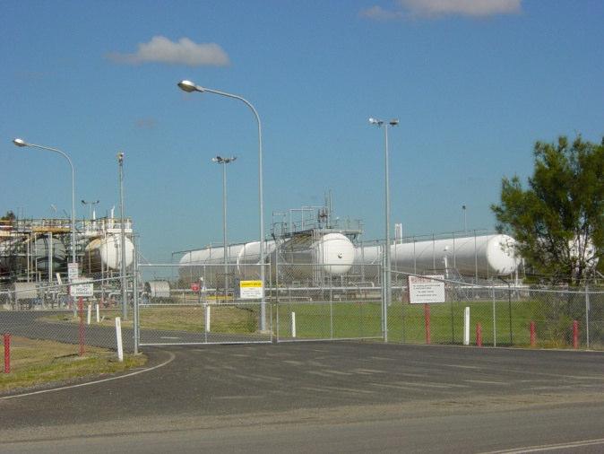
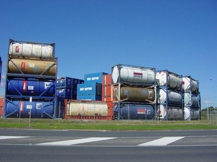
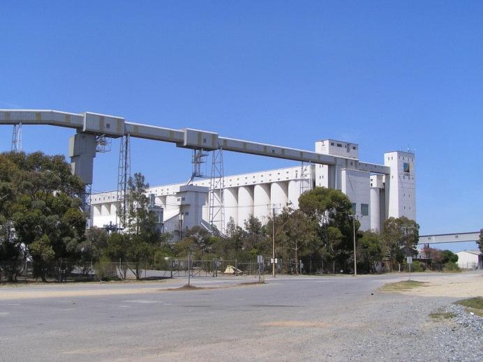
8 Brisbane 183 years on Main port facilities Bulk fuel Bulk chemicals Grain terminals Cement General cargo Old wool stores Ship building Slide No. 8

9 Newcastle 208 years on Aluminium smelter Bulk fuel Bulk chemicals Grain terminals Former BHP site Ship building Old wool stores Slide No. 9

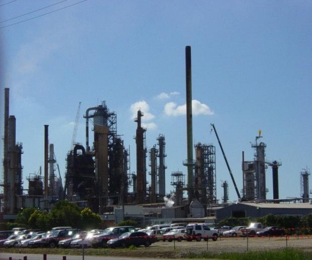
10 Port Adelaide 167 years on Power station Outer harbour Ship building Power station Bulk fuel Bulk chemicals Grain terminals Cement works Old wool stores Slide No. 10
11 Each city also has a well established planning scheme. Slide No. 11
12 But do they adequately address the risks posed by all hazards? Case studies reviewed: Inundation Destructive winds and earthquakes Hazardous materials Mobile hazards Slide No. 12
13 Each centre has adopted similar planning strategies to address inundation hazards including: 1% AEP defined flood event 1% AEP defined storm tide event Provision for climate change effects Slide No. 13
14 Some have established differential flood management strategies: 1% AEP for residential, commercial and light industrial 0.5% AEP for emergency shelters, police stations, archives, libraries, substations, etc 0.2% AEP for hospitals, emergency services, power stations & major switch yards, etc Slide No. 14
15 Flood-prone land mapping BRISBANE NEWCASTLE PORT ADELAIDE NFP NFP NFP Slide No. 15
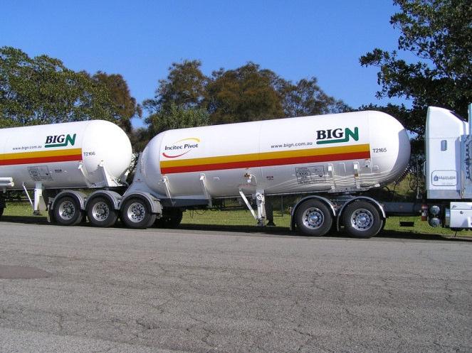
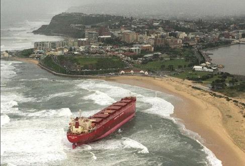
16 The Building Code of Australia is the primary mitigation strategy available for treating destructive wind and earthquake risks to new structures. Slide No. 16


17 Wind speed design zones Planning SA Slide No. 17
18 It s an increasingly hazardous chemical world! Slide No. 18


19 Secondary hazards Slide No. 19
20 Planning regulations governing the siting of most hazardous facilities emphasise environmental rather than community protection. Slide No. 20

21 Slide No. 21

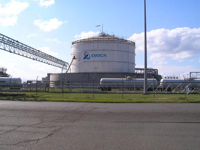
22 Separation distances compared FACILITY WESTERN AUSTRALIA OTHER STATES* Major fuel storage 200 to 1000m 100 to 500m Major chemical storage Up to 3000m 1000m Grain terminal 500m 300m * Victoria, NSW, SA, Queensland AAP photo Slide No. 22


23 Current development and significant hazardous facilities PORT CLOSEST HOUSE HOUSES WITHIN ZONE Brisbane ~460m <10 Newcastle ~175m ~1900 Adelaide ~60m ~2050 Slide No. 23


24 The risks posed by the transport of dangerous goods through developed areas are not adequately covered by the planning process. Matt Hayes photo AAP photo Slide No. 24

25 The choice of route can make a significant difference 2309 dwellings 598 dwellings Slide No. 25
26 The planning hierarchy Integrated Planning Act State Planning Policy 1/03 SEQ Regional Plan Brisbane City Plan Slide No. 26
27 The planning hierarchy #2 BCA Transport Infrastructure Act Integrated Planning Act State Planning Policy 1/03 Coastal Management Act Coastal Management Plan Port Land Use Plan SEQ Regional Plan SEQ Infrastructure Plan Building Act Brisbane City Plan Slide No. 27
28 The regulatory quagmire Commonwealth Legislation BCA OH&S Code ADG Code MHF Standard Local Government Act Disaster Management Act Fire & Rescue Services Act Workplace Health & Safety Act Transport Operations Acts Transport Infrastructure Act Environmental Protection Act Water Act Etc, etc Dangerous Goods Safety Management Act Explosives Act Gas Act Radiation Safety Act Petroleum Act Port Land Use Plan? Brisbane City Plan Slide No. 28
29 Planning is a balancing act Legislation Regulation Standards Plans Codes Existing development $ Slide No. 29
30 So is disaster risk management Legislation Standards Regulation Codes Plans Existing development Slide No. 30
31 CONCLUSION: Land use planning can have only a limited impact on the risks that already exist but can influence the growth of future risks... Slide No. 31
32 ... as long as an holistic, real-world approach is adopted... Slide No. 32
33 ... and officials accept that disaster risk management is an integral part of community governance. Slide No. 33
Residents Emergency Response Checklist
 COMMUNITY RESILIENCE PLAN Residents Emergency Response Checklist A helpful guide in the event of extreme weather or bushfire events. < PREVIOUS I NEXT > 02 Purchasing an existing property or building a
Assessing Hazards and Risk
 Page 1 of 6 EENS 204 Tulane University Natural Disasters Prof. Stephen A. Nelson Assessing Hazards and Risk This page last updated on 07-Jan-2004 As discussed before, natural disasters are produced by
COMMUNITY EMERGENCY RESPONSE TEAM
 COMMUNITY EMERGENCY RESPONSE TEAM INSTRUCTOR GUIDE 40 hour curriculum DEVELOPED FOR: FEDERAL EMERGENCY MANAGEMENT AGENCY EMERGENCY MANAGEMENT INSTITUTE UNITED STATES FIRE ADMINISTRATION DEVELOPED BY: HUMAN
Meeting the New Queensland Coastal Plan Storm Surge Requirements for Redland City Council. Queensland Coastal Conference 2011
 Meeting the New Queensland Coastal Plan Storm Surge Requirements for Redland City Council Ancient Knowledge Contemporary Innovation The Pullman Reef Hotel, Cairns Daniel Niven 1 and David Taylor 2 1 Cardno
Hurricane Readiness for Coastal Communities
 Hurricane Readiness for Participant Guide Developed for: Federal Emergency Management Agency Emergency Management Institute 16825 South Seton Avenue Emmitsburg, MD 21727-8998 Developed by: C² Technologies,
They include earthquakes, volcanic eruptions, floods, landslides, and other processes and occurrences. They are included in the broader concept of.
 They include earthquakes, volcanic eruptions, floods, landslides, and other processes and occurrences. They are included in the broader concept of. In general, natural processes are labeled hazardous only
Using Operating Experience to Prevent or Mitigate Nuclear Events. What Is, Was and Will Be Available
 Using Operating Experience to Prevent or Mitigate Nuclear Events What Is, Was and Will Be Available Introduction Remember, it is by understanding the lessons learned from past events that we can adequately
Risk-based land use and spatial planning
 Risk-based land use and spatial planning Miho OHARA International Centre for Water Hazards and Risk Management (ICHARM) Public Works Research Institute PWRI), Japan Under the auspices of UNESCO Introduction
Integrating Hydrologic and Storm Surge Models for Improved Flood Warning
 Integ Hydrologic and Storm Surge Models for Improved Flood Warning Leahy, C.P, Entel, M, Sooriyakumaran, S, and Warren, G Flood Warning Program Office, Bureau of Meteorology, Docklands, Victoria National
Word Cards. 2 map. 1 geographic representation. a description or portrayal of the Earth or parts of the Earth. a visual representation of an area
 Name: Date: Hour: Word Cards 1 geographic representation a description or portrayal of the Earth or parts of the Earth Example: A map is a representation of an actual location or place. 2 map a visual
Erin Mack Ashley, PhD, LEED AP Diana Castro, PE
 Impact and mitigation options for residential fires following Hurricane Sandy Erin Mack Ashley, PhD, LEED AP Diana Castro, PE June 9-14, 2013 Hurricane Hazards Storm Surge Winds Heavy Rain Tornadoes FIRE?
Vulnerability of Bangladesh to Cyclones in a Changing Climate
 Vulnerability of Bangladesh to Cyclones in a Changing Climate Susmita Dasgupta Kiran Pandey Mainul Huq Zahirul Huq Khan M.M. Zahid Ahmed Nandan Mukherjee Malik Fida Khan 2010 Bangladesh: Tropical Cyclone
CAIRNS AIRPORT CYCLONE PLAN
 CAIRNS AIRPORT CYCLONE PLAN Reference No: 2046 SO Version 5.1 6 th February 2018 2046_SO_CairnsCyclonePlan_V5.1_Effectivedate_06/02/2018_Reviewdate_06/02/2019 Page 1 of 10 Document Control Reference No
Pacific Catastrophe Risk Assessment And Financing Initiative
 Pacific Catastrophe Risk Assessment And Financing Initiative TIMOR-LESTE September Timor-Leste is expected to incur, on average, 5.9 million USD per year in losses due to earthquakes and tropical cyclones.
Pacific Catastrophe Risk Assessment And Financing Initiative
 Pacific Catastrophe Risk Assessment And Financing Initiative TUVALU is expected to incur, on average,. million USD per year in losses due to earthquakes and tropical cyclones. In the next 5 years, has
APPLICATIONS OF EARTHQUAKE HAZARD MAPS TO LAND-USE AND EMERGENCY PLANNING EXAMPLES FROM THE PORTLAND AREA
 APPLICATIONS OF EARTHQUAKE HAZARD MAPS TO LAND-USE AND EMERGENCY PLANNING EXAMPLES FROM THE PORTLAND AREA O. Gerald Uba Metro, Portland, Oregon OVERVIEW The extent to which we understand "below ground"
CAIRNS AIRPORT CYCLONE PLAN
 CAIRNS AIRPORT CYCLONE PLAN Reference No: 2046 SO Version 5 25 th October 2017 2046_SO_CairnsAirportCyclonePlan_V5_Effectivedate_25/10/2017_Reviewdate_25/10/2018 Page 1 of 10 Document Control Reference
Outline of Guideline for Development and Utilization of Tsunami Disaster Management Map
 Outline of Guideline for Development and Utilization of Tsunami Disaster Management Map Port and Airport Research Institute, Japan The Overseas Coastal Area Development Institute of Japan Ports and Harbours
Pacific Catastrophe Risk Assessment And Financing Initiative
 Pacific Catastrophe Risk Assessment And Financing Initiative PALAU September is expected to incur, on average,.7 million USD per year in losses due to earthquakes and tropical cyclones. In the next 5 years,
Assumption Parish Hazard Mitigation Plan Update Public Meeting. September 1, 2015 Napoleonville, LA
 Assumption Parish Hazard Mitigation Plan Update Public Meeting September 1, 2015 Napoleonville, LA Agenda Hazard Mitigation Planning Process SDMI Staff Risk Assessment SDMI Staff Update on Previous/Current
Pacific Catastrophe Risk Assessment And Financing Initiative
 Pacific Catastrophe Risk Assessment And Financing Initiative VANUATU September 211 Country Risk Profile: VANUATU is expected to incur, on average, 48 million USD per year in losses due to earthquakes and
Hurricanes. Environmental Geology Mr. Paul Lowrey. Stacey Singleton, Cassandra Combs, Dwight Stephenson, Matt Smithyman
 Environmental Geology Mr. Paul Lowrey Stacey Singleton, Cassandra Combs, Dwight Stephenson, Matt Smithyman Hurricanes EMPACTS Project, Spring 2017 Northwest Arkansas Community College, Bentonville, AR
Initiative. Country Risk Profile: papua new guinea. Better Risk Information for Smarter Investments PAPUA NEW GUINEA.
 Pacific Catastrophe Risk Assessment And Financing Initiative PAPUA NEW GUINEA September 211 Country Risk Profile: papua new is expected to incur, on average, 85 million USD per year in losses due to earthquakes
Pre-Disaster Natural Hazard Mitigation Plan Guilford, Connecticut History of Hazard Mitigation Planning Authority Disaster Mitigation Act of 2000 (ame
 Pre-Disaster Natural Hazard Mitigation Plan Guilford, Connecticut History of Hazard Mitigation Planning Authority Disaster Mitigation Act of 2000 (amendments to Stafford Act of 1988) Presented by: David
Local Area Key Issues Paper No. 13: Southern Hinterland townships growth opportunities
 Draft Sunshine Coast Planning Scheme Review of Submissions Local Area Key Issues Paper No. 13: Southern Hinterland townships growth opportunities Key Issue: Growth opportunities for Southern Hinterland
Interpretive Map Series 24
 Oregon Department of Geology and Mineral Industries Interpretive Map Series 24 Geologic Hazards, and Hazard Maps, and Future Damage Estimates for Six Counties in the Mid/Southern Willamette Valley Including
The Leader in Landscape Solutions
 The Leader in Landscape Solutions Emergency Action Plan Hurricane Preparedness Go To Mainscape.com For More Information! Purpose: To provide the Federation at Kings Point and their residents an informative
Mitigation planning in Epirus- The case of frost and snowfalls. Thematic seminar Epirus September 2011
 Mitigation planning in Epirus- The case of frost and snowfalls Thematic seminar Epirus September 2011 1 Structure of Mitigation Planning in Greece First Level: General Plan for Civil Protection Ksenokratis
AFAC 2006 page 536. Climate-Change Impacts on fire-weather in SE Australia Kevin Hennessy, Principal Research Scientist, CSIRO
 AFAC 2006 page 536 Climate-Change Impacts on fire-weather in SE Australia Kevin Hennessy, Principal Research Scientist, CSIRO AFAC 2006 page 537 Climate change impacts on fire-weather risk in south-east
Bossier Parish Hazard Mitigation Plan Update Public Meeting. August 10, 2016 Bossier City, LA
 Bossier Parish Hazard Mitigation Plan Update Public Meeting August 10, 2016 Bossier City, LA Agenda Hazard Mitigation Planning Process SDMI Staff Risk Assessment SDMI Staff Update on Previous/Current Mitigation
Planning for coastal hazards in a changing climate
 March 2013 Planning for coastal hazards in a changing climate Catherine Knight, Coastal and Estuary Officer Sharyn French, Manager Land and Natural Environment Presentation overview Stormy past Council
Table G - 6. Mitigation Actions Identified for Implementation by the City of Kent ( ) (From Wilkin County Master Mitigation Action Chart)
 (From Wilkin County Master Mitigation Action Chart)") Table G - 6. Actions Identified by the () (From Master Action Chart) Multi-Hazard Plan, 2017 Action Comments 5 All-Hazards Local Planning & Regulations Update the Operations Plan on an annual basis. Work
Table G - 6. Actions Identified by the () (From Master Action Chart) Multi-Hazard Plan, 2017 Action Comments 5 All-Hazards Local Planning & Regulations Update the Operations Plan on an annual basis. Work
West Carroll Parish Hazard Mitigation Plan Update Public Meeting. August 25, 2015 Oak Grove, LA
 West Carroll Parish Hazard Mitigation Plan Update Public Meeting August 25, 2015 Oak Grove, LA Agenda Hazard Mitigation Planning Process SDMI Staff Risk Assessment SDMI Staff Update on Previous/Current
Earthquakes. & Expansive Soils
 Earthquakes & Expansive Soils January 22, 2009 Plan Update Flanagan & Associates, LLC Consultants Tulsa, OK www.rdflanagan.com rdflanagan@rdflanagan.com Plan can be reviewed at: www.rdflanagan.com/.html
Fire Weather Drivers, Seasonal Outlook and Climate Change. Steven McGibbony, Severe Weather Manager Victoria Region Friday 9 October 2015
 Fire Weather Drivers, Seasonal Outlook and Climate Change Steven McGibbony, Severe Weather Manager Victoria Region Friday 9 October 2015 Outline Weather and Fire Risk Environmental conditions leading to
Natural Disasters & Assessing Hazards and Risk. Natural Hazards and Natural Disasters
 Page 1 of 9 EENS 3050 Tulane University Natural Disasters Prof. Stephen A. Nelson Natural Disasters & Assessing Hazards and Risk This page last updated on 09-Jan-2018 Natural Hazards and Natural Disasters
Estimating the impacts of beach erosion and cyclones on coastal property values: A Queensland case study Qing Han Walter Hein, Boon Lee and Clevo
 Estimating the impacts of beach erosion and cyclones on coastal property values: A Queensland case study Qing Han Walter Hein, Boon Lee and Clevo Wilson Background to the study Beach erosion is common
NGIAs' roles in successful disaster response
 The Second UN-GGIM-AP Plenary Meeting NGIAs' roles in successful disaster response Japan Teheran Iran 28 October 2013 Shin-ichi SAKABE, Director of International Affairs Division Geospatial Information
Like other coastal cities, Honolulu s
 Worst-Case Scenarios: Flooding and Evacuation Plans in Honolulu Karl Kim, Pradip Pant, Eric Yamashita Like other coastal cities, Honolulu s long-term viability depends on how well it can adapt to climate
KNOWLEDGE NOTE 5-1. Risk Assessment and Hazard Mapping. CLUSTER 5: Hazard and Risk Information and Decision Making. Public Disclosure Authorized
 Public Disclosure Authorized Public Disclosure Authorized Public Disclosure Authorized Public Disclosure Authorized KNOWLEDGE NOTE 5-1 CLUSTER 5: Hazard and Risk Information and Decision Making Risk Assessment
Application #: TEXT
 TOWN OF FORT MYERS BEACH 2008 PROPOSED COMPREHENSIVE PLAN AMENDMENTS Application #: 2008-13-TEXT Description: Modify the Coastal Management and Future Land Use Elements to reflect the state s new definition
Table-Top Exercise for Emergency Preparedness Evaluation: Little Anse, Isle Madame
 Table-Top Exercise for Emergency Preparedness Evaluation: Little Anse, Isle Madame Alexander Chung, M.Sc. Candidate C-Change Student Research Associate May 2013 The Community of Little Anse Coastal community
Activities and Outlook related to Disaster Reduction in CMA
 Activities and Outlook related to Disaster Reduction in CMA WANG Bangzhong China Meteorological Administration March 15-17 2006 ADENDA Situation about MD and related disasters in CHINA Guidance for MD/RD
Integrating Sea Level Rise and Storm Surges in Local Planning. October 2017
 Integrating Sea Level Rise and Storm Surges in Local Planning October 2017 Published by: Norwegian Directorate for Civil Protection Rambergveien 9 3115 Tønsberg, Norway Phone 33 41 25 00 Fax 33 31 06 60
HAZUS-MH: A Predictable Hurricane Risk Assessment Tool for the City of Houston and Harris County
 HAZUS-MH: A Predictable Hurricane Risk Assessment Tool for the City of Houston and Harris County Presented by Melvin G. Spinks, P.E., President Annie Ding, PhD, GISP October 29, 2008 Rice University Contents
West Baton Rouge Parish Hazard Mitigation Plan Update Public Meeting. September 9, 2015 Port Allen, LA
 West Baton Rouge Parish Hazard Mitigation Plan Update Public Meeting September 9, 2015 Port Allen, LA Agenda Hazard Mitigation Planning Process SDMI Staff Risk Assessment SDMI Staff Update on Previous/Current
Surviving the Big One: Understanding and Preparing for a Major Earthquake in Western Oregon
 Surviving the Big One: Understanding and Preparing for a Major Earthquake in Western Oregon May 21, 2013 City of Salem Salem Public Library Althea Rizzo, Geological Hazards Program Coordinator Oregon Emergency
2014 Russell County Hazard Mitigation Plan Update STAKEHOLDERS AND TECHNICAL ADVISORS MEETING 2/6/14
 2014 Russell County Hazard Mitigation Plan Update STAKEHOLDERS AND TECHNICAL ADVISORS MEETING 2/6/14 Welcome and Introductions We cannot direct the wind, but we can adjust our sails. 44 CFR 201.6; Local
An examination of accident compensation claims during natural hazard events. Rosi Winn, Alice Huston & Catherine Weston
 An examination of accident compensation claims during natural hazard events Rosi Winn, Alice Huston & Catherine Weston Flood claims could climb as high as $6b SMH 25/1/11 Victoria on heat alert The Australian
Safety Issue: Types of weather emergencies and natural. Weather Emergencies
 Overview Safety Issue: Rapid and effective response to weather emergencies and other natural disasters whether during or after work hours takes forethought and careful planning. Types of weather emergencies
Queensland Floods- Part A
 Queensland Floods- Part A Floods Flooding is when the water level in a creek, river, lake or the sea rises and covers land that is normally dry. The rise in water can be due to numerous causes, although
Cyclone Tracy 30-Year Retrospective
 Cyclone Tracy 30-Year Retrospective TM Risk Management Solutions C HARACTERISTICS Cyclone Tracy struck the city of Darwin on the northern coast of Australia early Christmas Day, 1974, causing immense devastation.
Tropical Cyclone Oswald Coastal Monitoring
 Tropical Cyclone Oswald Coastal Monitoring Kieran Harper and John Maher Coastal Impacts Unit, Queensland Department of Science, Information Technology, Innovation and the Arts (DSITIA). 27 Quinlan St Deagon,
Coastal Inundation Forecasting Demonstration Project CIFDP. Flood Forecasting Initiative-Advisory Group (FFI-AG 3), Geneva, 5-7 Dec, 2017
, Geneva, 5-7 Dec, 2017") Coastal Inundation Forecasting Demonstration Project CIFDP Flood Forecasting Initiative-Advisory Group (FFI-AG 3), Geneva, 5-7 Dec, 2017 Coastal Flooding & Vulnerable Populations Coastal populations are
Coastal Inundation Forecasting Demonstration Project CIFDP Flood Forecasting Initiative-Advisory Group (FFI-AG 3), Geneva, 5-7 Dec, 2017 Coastal Flooding & Vulnerable Populations Coastal populations are
Hazard Vulnerability Analysis (HVA)
") Hazard Vulnerability Analysis (HVA) What is an HVA Systematic approach to recognizing hazards that may effect the ability to care for residents The risks associated with each hazard are analyzed to prioritize
Hazard Vulnerability Analysis (HVA) What is an HVA Systematic approach to recognizing hazards that may effect the ability to care for residents The risks associated with each hazard are analyzed to prioritize
5.2. IDENTIFICATION OF NATURAL HAZARDS OF CONCERN
 5.2. IDENTIFICATION OF NATURAL HAZARDS OF CONCERN To provide a strong foundation for mitigation strategies considered in Sections 6 and 9, County considered a full range of natural hazards that could impact
IN VEHICLES: Do not try to outrun a tornado. Abandon your vehicle and hide in a nearby ditch or depression and cover your head.
 TORNADO SAFETY TORNADO! The very word strikes fear in many people. While a tornado is perhaps nature's most destructive storm, deaths and injuries can be prevented. By following Tornado Safety Rules, lives
BLUEFIELDS EMERGENCY PLATFORM:
 BLUEFIELDS EMERGENCY PLATFORM: Community Early Warning Systems for Mitigating Hydro-Meteorological Impacts in Bluefields, Jamaica T. Hyman, J. Horney, B. Carby, K. Miller, M. Taylor OUTLINE Background
Running Head: HAZARD MITIGATION PLAN OUTLINE FOR MISSISSIPPI 1
 Running Head: HAZARD MITIGATION PLAN OUTLINE FOR MISSISSIPPI 1 Hazard Mitigation Plan Outline for Mississippi Name: Institution: HAZARD MITIGATION PLAN OUTLINE FOR MISSISSIPPI 2 Hazard Mitigation Plan
From Vulnerability to Resilience And the Tools to Get There. Out of Harm s Way Partnership for the Delaware Estuary August 1, 2012
 From Vulnerability to Resilience And the Tools to Get There Out of Harm s Way Partnership for the Delaware Estuary August 1, 2012 Today s Presentation Tour of New Jersey Challenges Definitions so we re
Oregon APA Legal Issues Workshop December 7, Tricia Sears, DLCD With information from Bill Burns, DOGAMI
 Oregon APA Legal Issues Workshop December 7, 2018 Tricia Sears, DLCD With information from Bill Burns, DOGAMI How this Topic Arrived WE FREQUENTLY HEAR CONCERNS ABOUT LIABILITY AND TAKINGS. Current federal
Baldwin County, Alabama
 2015 Baldwin County, Alabama Multi-Hazard Mitigation Plan I. Comprehensive Plan A multi-jurisdiction plan City of Bay Minette City of Daphne Town of Elberta City of Fairhope City of Foley City of Gulf
The Wind Hazard: Messaging the Wind Threat & Corresponding Potential Impacts
 The Wind Hazard: Messaging the Wind Threat & Corresponding Potential Impacts Scott Spratt Warning Coordination Meteorologist NWS Melbourne, FL David Sharp Science & Operations Officer NWS Melbourne, FL
City of Punta Gorda Community Emergency Management Plan 2013
 City of Punta Gorda Community Emergency Management Plan 2013 Hurricane Andrew- August 24, 1992 Category 5 hurricane. The second-most-destructive hurricane in U.S. history. The first named storm of the
Exercise Brunswick ALPHA 2018
 ALPHA Exercise Brunswick ALPHA 2018 Who we are (our structure) What we do (our forecasts) How you can access the information Tropical cyclone information (basic) Overview of the products used for Exercise
SECTION IV ASSESSING VULNERABILITY AND RISK
 SECTION IV ASSESSING VULNERABILITY AND RISK Describing vulnerability in terms of potential dollar loss provides the local government, the State and the federal government with a common framework with which
ÖBB Natural Hazard Management
 ÖBB Natural Hazard Management Management of Weather Events in the Austrian Federal Railways MOWE-IT, Brussels 17 th of September 2013 DI Günther Kundela Integrated Track Management Integration Technic
Page G Crow Wing County Multi-Hazard Mitigation Plan, 2017
 Table G - 10. s Identified by the () (From Crow Wing County Master Chart) 1 5 All- Hazards All- Hazards Work to ensure that all Crow Wing County residents are aware of and sign-up for the County s Emergency
Layers (Layers in italics indicate group layers.) MyHazards MyPlan* Floods and Drought Landslides - USGS
 MyHazards MyPlan* Floods and Drought Landslides - USGS") MyHazards and MyPlan WebApps for Nevada Geohazards Over 100 hazard layers related to floods, fires, earthquakes, radon, and other supporting reference layers. Powerful educational and decision-making tools
MyHazards and MyPlan WebApps for Nevada Geohazards Over 100 hazard layers related to floods, fires, earthquakes, radon, and other supporting reference layers. Powerful educational and decision-making tools
4.2: Disaster Mitigation Strategies
 WMO/CAS/WWW SEVENTH INTERNATIONAL WORKSHOP ON TROPICAL CYCLONES 4.2: Disaster Mitigation Strategies Rapporteurs: Bill Read Regional Specialized Meteorological Center (RSMC) WMO Region IV 11691 SW 17 th
Wildfire Preparedness
 Wildfire Preparedness Wildfires are common disasters that can spread quickly, especially during dry conditions. More than 100,000 wildfires clear 4-5 million acres of land in the US every year. Wildfires
Storm Surge/Coastal Inundation State of the Union. Jamie Rhome Storm Surge Team Lead NOAA/National Hurricane Center
 Storm Surge/Coastal Inundation State of the Union Jamie Rhome Storm Surge Team Lead NOAA/National Hurricane Center 2 Tampa: Cat 5 Scenario 3 4 The Stakes are High Combination of SLR and increasing coastal
Why Are Communities at Risk from Coastal Hazards?
 Chapter 2 Why Are Communities at Risk from Coastal Hazards? The Indian Ocean Tsunami of December 2004 raised awareness worldwide of the potentially devastating impacts of tsunamis. Coastal communities
Use of Geospatial data for disaster managements
 Use of Geospatial data for disaster managements Source: http://alertsystemsgroup.com Instructor : Professor Dr. Yuji Murayama Teaching Assistant : Manjula Ranagalage What is GIS? A powerful set of tools
Remote sensing and GIS for multi-hazard risk assessments in the coastal zone: recent applications and challenges in the Pacific Jens Kruger
 Remote sensing and GIS for multi-hazard risk assessments in the coastal zone: recent applications and challenges in the Pacific Jens Kruger Geoscience Division Pacific Community (SPC) The First Pacific
Alignments of Master of Disaster (MoD) Lessons for Grades K-2 with the Next Generation Science Standards (NGSS) X X X X X X X X X X
 Lessons for Grades K-2 with the Next Generation Science Standards (NGSS) X X X X X X X X X X") Alignments of Master of Disaster (MoD) Lessons for Grades K-2 with the Next Generation Science Standards (NGSS) Relevant Next Generation Science Standards Performance Expectations* MoD Lesson Purpose K-PS2-1
Alignments of Master of Disaster (MoD) Lessons for Grades K-2 with the Next Generation Science Standards (NGSS) Relevant Next Generation Science Standards Performance Expectations* MoD Lesson Purpose K-PS2-1
Appendix 2. Extracts from Ministry for the Environment Active Fault Guidelines 2003
 Extracts from Ministry for the Environment Active Fault Guidelines 2003 Published in July 2003 by the Ministry for the Environment Manatu Mo Te Taiao PO Box 10-362, Wellington, New Zealand ISBN: 0-478-18901
Hurricanes. Cause: a low pressure storm system over warm ocean water. Effect: potential massive widespread destruction and flooding.
 Hurricanes Hurricanes Cause: a low pressure storm system over warm ocean water. Effect: potential massive widespread destruction and flooding. Hurricanes also known as: cyclone (Indian Ocean) or typhoon
United States Multi-Hazard Early Warning System
 United States Multi-Hazard Early Warning System Saving Lives Through Partnership Lynn Maximuk National Weather Service Director, Central Region Kansas City, Missouri America s s Weather Enterprise: Protecting
KENTUCKY HAZARD MITIGATION PLAN RISK ASSESSMENT
 KENTUCKY HAZARD MITIGATION PLAN RISK ASSESSMENT Presentation Outline Development of the 2013 State Hazard Mitigation Plan Risk Assessment Determining risk assessment scale Census Data Aggregation Levels
Background and History
 p1 Background and History What is the Indian Ocean Climate Initiative? The Indian Ocean Climate Initiative (IOCI) is a strategic program of research and information transfer to support government decision-making.
Appendix C Fluvial Flood Hazards
 Appendix C Fluvial Flood Hazards Sea Level Rise Vulnerability Assessment and Adaptation Project March 2019 Contents Contents... i Figures... i Tables... i Definitions, Acronyms, & Abbreviations... ii
142 HAIL CLIMATOLOGY OF AUSTRALIA BASED ON LIGHTNING AND REANALYSIS
 142 HAIL CLIMATOLOGY OF AUSTRALIA BASED ON LIGHTNING AND REANALYSIS Christopher N. Bednarczyk* Peter J. Sousounis AIR Worldwide Corporation, Boston, MA 1. INTRODUCTION * The highly uneven distribution
2014 Annual Mitigation Plan Review Meeting
 2014 Annual Mitigation Plan Review Meeting Highland County EMA MEETING OBJECTIVES Understand Your Natural Disaster Risk Review of Previous Plans Current Plan Status Future Activity Plan/Needs of Each Community
This table connects the content provided by Education Perfect to the NSW Syllabus.
 Education Perfect Geography provides teachers with a wide range of quality, engaging and innovative content to drive positive student learning outcomes. Designed by teachers and written by our in-house
Hazard Resilience Index (HRI) Earthquakes, Tsunamis, and Volcanoes
 Earthquakes, Tsunamis, and Volcanoes") Hazard Index (HRI) Earthquakes, Tsunamis, and Volcanoes Earthquakes Tsunamis Volcano-Ash Falls, Projectiles and Lateral Blasts, Pyroclastic Flows and Lava Flows Earthquakes, Tsunamis and Volcanoes Please
Hazard Index (HRI) Earthquakes, Tsunamis, and Volcanoes Earthquakes Tsunamis Volcano-Ash Falls, Projectiles and Lateral Blasts, Pyroclastic Flows and Lava Flows Earthquakes, Tsunamis and Volcanoes Please
USING 3D GIS TO ASSESS ENVIRONMENTAL FLOOD HAZARDS IN MINA
 King Fahd University of Petroleum & Minerals College of Environmental Design Geographical Information system USING 3D GIS TO ASSESS ENVIRONMENTAL FLOOD HAZARDS IN MINA Prepared by : Ali AL-Zahrani OUTLINE
REPORT TO THE PLANNING, TRANSPORTATION AND PROTECTIVE SERVICES COMMITTEE MEETING OF JUNE 26, 2013
 PPS/PS 2013-07 REPORT TO THE PLANNING, TRANSPORTATION AND PROTECTIVE SERVICES COMMITTEE MEETING OF JUNE 26, 2013 SUBJECT UPDATES TO THE CAPITAL REGIONAL DISTRICT MODELLING OF POTENTIAL TSUNAMI INUNDATION
STORM SURGE EVACUATION GUIDE
 STORM SURGE EVACUATION GUIDE STORM TIDE EVACUATION MAPS Living in a cyclone prone region triggers a need for a heightened level of awareness in our community... All threats outlined in the Hinchinbrook
Queensland Storm Surge Forecasting Model Design Using Sensitivity Analysis
 21st International Congress on Modelling and Simulation, Gold Coast, Australia, 29 Nov to 4 Dec 215 www.mssanz.org.au/modsim215 Queensland Storm Surge Forecasting Model Design Using Sensitivity Analysis
Improving global coastal inundation forecasting WMO Panel, UR2014, London, 2 July 2014
 Improving global coastal inundation forecasting WMO Panel, UR2014, London, 2 July 2014 Cyclone Sidr, November 2007 Hurricane Katrina, 2005 Prof. Kevin Horsburgh Head of marine physics, UK National Oceanography
Daily Operations Briefing. Sunday, October 22, :30 a.m. EDT
 Daily Operations Briefing Sunday, October 22, 2017 8:30 a.m. EDT Significant Activity Oct 21-22 Significant Events: Response and recovery Harvey, Irma, Maria; CA Wildfires Tropical Activity: Atlantic No
Timeframe. Crow Wing County, Baxter, Brainerd, Breezy Point, Crosby, Crosslake, Cuyuna, Deerwood, Emily, Fifty
 Table G - 13. s Identified for by the () (From Crow Wing County Master Chart) 1 5 9 All- Hazards All- Hazards Winter Work to ensure that all Crow Wing County residents are aware of and sign-up for the
TORNADO/high winds *
 TORNADO/high winds * WATCH Bring people inside. Secure outside objects. Clear window ledges & wall hangings Close drapes Protect windows Assemble and check supplies Call in applicable staff Pre-Storm:
Modelling the effect of sea level rise on tropical cyclone storm surge impact
 21st International Congress on Modelling and Simulation, Gold Coast, Australia, 29 Nov to 4 Dec 2015 www.mssanz.org.au/modsim2015 Modelling the effect of sea level rise on tropical cyclone storm surge
Daily Operations Briefing. Sunday, October 1, :30 a.m. EDT
 Daily Operations Briefing Sunday, October 1, 2017 8:30 a.m. EDT Significant Activity Sep 30 - Oct 1 Significant Events: Response for Hurricane Maria Tropical Activity: Atlantic Disturbance 1 Eastern Pacific
Natural Processes. Were you prepared for the fast approaching storm? Were you able to take shelter? What about pets, livestock or plants?
 Have you ever been caught in a storm? You are outside on a summer night and all of a sudden here come the wind, lightning and heavy rain. It starts raining so hard that you can hardly see in front of you.
SEISMIC RISK ASSESSMENT IN ARMENIA
 SEISMIC RISK ASSESSMENT IN ARMENIA Hovhannes Khangeldyan Head of National Crisis Management Center Rescue Service Ministry of Emergency Situations of the Republic of Armenia Tokyo, 2016 ARMENIA: GEOGRAPHICAL
June 2018 Sediments and Dredging at GBR Ports
 June 2018 Sediments and Dredging at GBR Ports Reef 2050 Long Term Sustainability Plan The Great Barrier Reef is over 2000 km long and covers an area of approximately 350,000 square kilometres. It is a
Chippewa County Natural Hazards Mitigation Plan
 2014 Chippewa County Natural Hazards Mitigation Plan Prepared for: Chippewa County Office of Emergency Management With the Assistance of: Eastern U.P. Regional Planning & Development Commission April,