Tsunami Response and the Enhance PTWC Alerts
|
|
|
- Luke Simpson
- 6 years ago
- Views:
Transcription

1 Tsunami Response and the Enhance PTWC Alerts Ken Gledhill GeoNet Project Director Chair, Intergovernmental Coordination Group, Pacific Tsunami Warning and Mitigation System (PTWS)
2 Overview 1. Procedures 2. Why Enhanced PTWC Products? 3. Event timeline for the Enhanced Products 4. Examples of the Enhanced Products 5. Example: Japan 2011
3 Tsunami Response (1) 1. The response is initiated by either a message from the Pacific Tsunami Warning Centre (PTWC) or the location of an earthquake by GeoNet. 2. Preliminary advice to MCDEM on the likely threat to New Zealand is based only on PTWC and/or GeoNet information (supplemented by United States Geological Survey (USGS) National Earthquake Information Center (NEIC) information) Predefined thresholds levels for magnitude, depth and location are used. 3. management are advised, and extra resources requested If required.
4 Tsunami Response (2) 4. A Liaison Officer (Scientist) is made available to the National Crisis Management Centre if activated. For a local or regional event there may not be time for this to occur. 5. The Tsunami Experts Panel (TEP) is activated if the event will allow time for detailed discussions. For a local or regional event there may not be time for this to occur. 4. MCDEM are advised of threats to regions of New Zealand based on the Tsunami Scenario Models, and expected arrival times at key localities on the New Zealand coast, by utilising Tsunami Travel Time software.
5 Tsunami Response (3) 7. The first detailed advice to MCDEM on the likely impact to New Zealand is provided within one hour based on: a. Current earthquake parameters and sea-level data; b. Available tsunami forecast models (Tsunami Scenario Models, WebSIFT); c. Historical tsunami information. 8. Hourly updates are provided to MCDEM even if there is no new information and after each new message from PTWC. 9. Advice is provided on all clear based on tsunami propagation models and observed sea level data. Large surges and strong currents are possible many hours after the first arrival.


6 Tsunami Experts Panel The role of the Tsunami Experts Panel (TEP) is to support the GeoNet Duty Team in its provision of authoritative scientific advice to MCDEM on the likely impacts of tsunami. The TEP is comprised of 14 New Zealand resident scientists Expertise in seismology, plate tectonics, historical tsunami impacts, water modelling, or inundation. Temperament to allow working collegially and under pressure

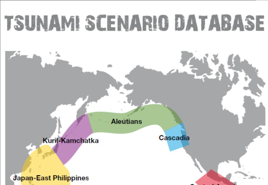
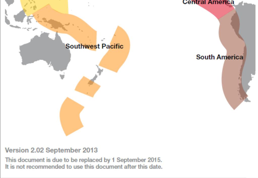
7 Tsunami Scenario Database
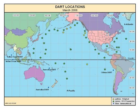
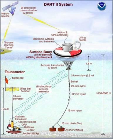
8 Tsunami Monitoring DART Buoys


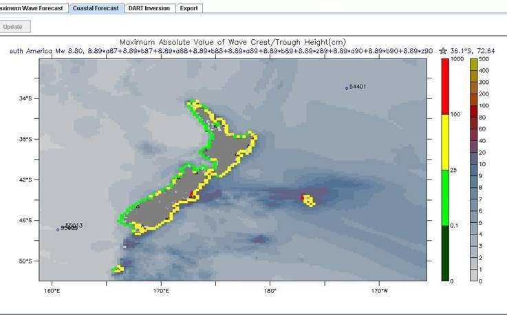
9 WebSIFT Tsunami Forecast modelling
10 Overview 1. Procedures 2. Why Enhanced PTWC Products? 3. Event timeline for the Enhanced Products 4. Examples of the Enhanced Products 5. Example: Japan 2011
11 Why Enhanced PTWC Products? Introduction Current PTWC Products effectively put the whole Pacific Ocean into warning following a large earthquake, despite the fact that the tsunami will be minor in most locations Over the last decade very good forecast models have been developed and tested which can indicate the possible size of a tsunami at a given location During recent years the Pacific Tsunami Warning & Mitigation System (PTWS) has been developing new protocols and messaging to alert countries of tsunami threats Tsunami modelling tools can be used to provide countries with a more realistic estimate of the level of threat they can expect from earthquake induced tsunami Starting in May this year (2013) the Pacific Tsunami Warning Center in Hawaii began issuing Enhanced Products on an experimental basis (in parallel with current official messaging). These will replace the current messages in October 2014.
12 Based primarily on numerical tsunami forecasts Initial forecast based on preliminary earthquake parameters (location, depth and magnitude) Initial products issued in less than 10 min Later forecasts constrained by earthquake mechanism and sea level readings. Text (public) as well as graphical information for NWC No alert levels, watches or warnings this is left to national authorities Only 3 general threat levels (a part from no threat ): 0.3-1m 1-3m >3m Why Enhanced PTWC Products? The New:
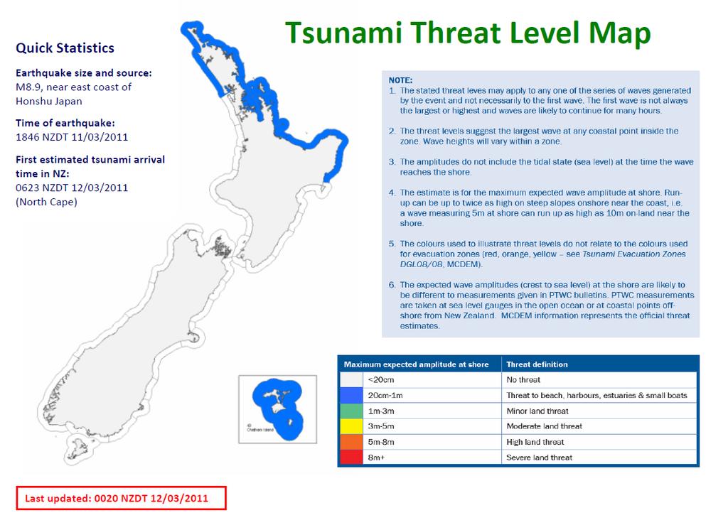
13 Tsunami Threat Levels (New Zealand) Maximum water level along coastal sections Threat Levels: 20cm - 1m Marine and beach threat 1m - 3m Marine and land threat 3m - 5m 5m 8m 8m+ Wave run-up is potentially up to twice as high (on steep slopes and v-shaped valleys near the coast) Tidal states are not included in the threat levels
14 Overview 1. Procedures 2. Why Enhanced PTWC Products? 3. Event timeline for the Enhanced Products 4. Examples of the Enhanced Products 5. Example: Japan 2011
15 Sample Timeline (1) 00h00m 00h02m 00h08m 00h10m A large earthquake occurs in the Pacific region Vibrations from the earthquake reach seismic stations near the earthquake epicenter, triggering event alarms at PTWC. PTWC duty analysts respond and begin to analyze the event. Using a combination of automatic and interactive analyses, duty analysts complete their preliminary determination of the earthquake epicenter, depth, and magnitude. These parameters are used to initiate runs of numerical tsunami forecast models for a limited region near the epicenter. A. If there is no tsunami threat because the earthquake is too small or too deep inside the earth or inland, then the initial product will just be an Information Statement.
16 Sample Timeline (2) 00h10m Initial Product. The type of product issued will depend on the estimate threat: B. If there is a potential tsunami threat, then the initial product may either be 1. The entire suite of products with the initial forecast amplitudes or 2. A text product only containing the earthquake parameters and a statement to the effect that earthquakes of this size and location typically pose a tsunami threat but that it has not yet been quantified and the forecast will follow later. (Option B.2 may be necessary to indicate a potential threat as quickly as possible but avoid issuing a misleading forecast if it is too poorly constrained with the initial seismic data) 00h20m If the earthquake parameters change significantly from what was in the initial bulletin then the forecasts are re-run. If there is a significant change in the forecasts then appropriate supplemental products, similar to those described above, are issued.
17 Sample Timeline (3) 00h25m The seismic analyses continue as data from additional seismic stations arrive and are processed For earthquakes above about magnitude 7.0, a preliminary mechanism for the earthquake is available about this time. The mechanism helps constrain the estimate of seafloor changes that causes tsunami, and is used in re-runs of the forecast models that covers the entire Pacific. 00h35m Up to 02h00m For events with a tsunami threat, additional messages are issued based upon the earthquake mechanism and includes maps, table, and other products that cover the entire Pacific region and marginal seas of the PTWS. Within the first 2 hours, and depending upon where the earthquake occurs, the tsunami will arrive and be measured on the nearest one or two coastal gauges and one or two deep-ocean gauges.
18 Sample Timeline (4) Sea level data is used to refine the modeling and messages 01h00m to 03h00m As observations of tsunami waves become available, they will be used to compare with existing forecasts and to adjust those forecasts when necessary. Updates will be provided at least once per hour. Typically, the forecast will become stable after a few readings from deep-ocean gauges and not require further adjustment. Products will be issued at least once an hour with any updated forecasts. Beyond 3h The tsunami is monitored on coastal and deep-ocean sea-level gauges as it advances. Reports from Member States and the media may also be received. When it is clear there is no longer a significant tsunami threat or the tsunami has crossed the entire Pacific then a final product is issued. This is not an all clear but will just state it is the last message for this event it is up to countries to provide the all clear for their citizens
19 Overview 1. Procedures 2. Why Enhanced PTWC Products? 3. Event timeline for the Enhanced Products 4. Examples of the Enhanced Products 5. Example: Japan 2011
20 ZCZC WEPA40 PHEB TSUPAC Sample Text Product EXPERIMENTAL TSUNAMI MESSAGE NUMBER 1 NOT FOR DISTRIBUTION NWS PACIFIC TSUNAMI WARNING CENTER EWA BEACH HI 0008 UCT THU AUG TSUNAMI THREAT MESSAGE... **** NOTICE **** NOTICE **** NOTICE **** NOTICE **** NOTICE ***** THIS MESSAGE IS ISSUED FOR INFORMATION ONLY IN SUPPORT OF THE UNESCO/IOC PACIFIC TSUNAMI WARNING AND MITIGATION SYSTEM AND IS MEANT FOR NATIONAL AUTHORITIES IN EACH COUNTRY OF THAT SYSTEM. NATIONAL AUTHORITIES WILL DETERMINE THE TSUNAMI THREAT AND APPROPRIATE LEVEL OF ALERT FOR EACH COUNTRY. **** NOTICE **** NOTICE **** NOTICE **** NOTICE **** NOTICE *****
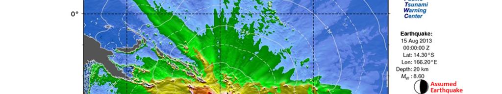
21 Sample Text Product PRELIMINARY EARTHQUAKE PARAMETERS * MAGNITUDE 8.6 * ORIGIN TIME 0000 UTC AUG * COORDINATES 14.3 SOUTH EAST * DEPTH 20 KM / 12 MILES * LOCATION VANUATU EVALUATION * AN EARTHQUAKE WITH A PRELIMINARY MAGNITUDE OF 8.6 OCCURRED IN THE VANUATU ISLANDS AT 0000 UTC ON THURSDAY AUGUST * BASED ON THE PRELIMINARY EARTHQUAKE PARAMETERS... HAZARDOUS TSUNAMI WAVES ARE FORECAST FOR SOME COASTS. * ACTUAL AMPLITUDES AT THE COAST MAY VARY FROM FORECAST AMPLITUDES DUE TO UNCERTAINTIES IN THE FORECAST AND LOCAL FEATURES. IN PARTICULAR, MAXIMUM TSUNAMI AMPLITUDES ON ATOLLS WILL LIKELY BE MUCH SMALLER THAN THE FORECAST INDICATES
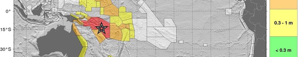
22 Sample Text Product TSUNAMI THREAT FORECAST...UPDATED * TSUNAMI WAVES REACHING MORE THAN 3 METERS ABOVE THE TIDE LEVEL ARE POSSIBLE ALONG SOME COASTS OF VANUATU... SOLOMON ISLANDS... AND PAPUA NEW GUINEA. * TSUNAMI WAVES REACHING 1 TO 3 METERS ABOVE THE TIDE LEVEL ARE POSSIBLE ALONG SOME COASTS OF AUSTRALIA... NEW CALEDONIA... MARSHALL ISLANDS... FIJI... SAMOA... KIRIBATI... AND WALLIS AND FUTUNA. * TSUNAMI WAVES REACHING 0.3 TO 1 METERS ABOVE THE TIDE LEVEL ARE POSSIBLE FOR SOME COASTS OF NEW ZEALAND... AMERICAN SAMOA... TOKELAU... NAURU... HOWLAND AND BAKER... TONGA... TUVALU... AND NIUE. * FOR OTHER AREAS COVERED BY THIS PRODUCT A FORECAST HAS NOT YET BEEN COMPUTED. THE FORECAST WILL BE EXPANDED AS NECESSARY IN SUBSEQUENT PRODUCTS.
23 RECOMMENDED ACTIONS Sample Text Product * GOVERNMENT AGENCIES RESPONSIBLE FOR THREATENED COASTAL AREAS SHOULD TAKE ACTION TO INFORM AND INSTRUCT ANY COASTAL POPULATIONS AT RISK IN ACCORDANCE WITH THEIR OWN EVALUATION... PROCEDURES AND THE LEVEL OF THREAT. * PERSONS LOCATED IN THREATENED COASTAL AREAS SHOULD FOLLOW INSTRUCTIONS FROM NATIONAL AND LOCAL AUTHORITIES.

24 Sample Text Product

25 Sample Text Product

26 Overview 1. Procedures 2. Why Enhanced PTWC Products? 3. Event timeline for the Enhanced Products 4. Examples of the Enhanced Products 5. Example: Japan 2011
27
28

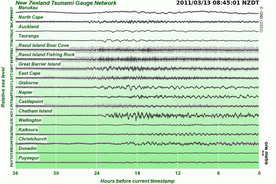
29 Tsunami Gauge Network
30
Establishment and Operation of a Regional Tsunami Warning Centre
 Establishment and Operation of a Regional Tsunami Warning Centre Dr. Charles McCreery, Director NOAA Richard H. Hagemeyer Pacific Tsunami Warning Center Ewa Beach, Hawaii USA Why A Regional Tsunami Warning
METEOROLOGICAL WARNINGS STUDY GROUP (METWSG)
") METWSG/4-SN No. 6 12/3/12 METEOROLOGICAL WARNINGS STUDY GROUP (METWSG) FOURTH MEETING Montréal, 15 to 18 May 2012 Agenda Item 6: Wind shear, turbulence and tsunami warnings TSUNAMI INFORMATION (Presented
METWSG/4-SN No. 6 12/3/12 METEOROLOGICAL WARNINGS STUDY GROUP (METWSG) FOURTH MEETING Montréal, 15 to 18 May 2012 Agenda Item 6: Wind shear, turbulence and tsunami warnings TSUNAMI INFORMATION (Presented
Indian Ocean Tsunami Warning System: Example from the 12 th September 2007 Tsunami
 Indian Ocean Tsunami Warning System: Example from the 12 th September 2007 Tsunami Charitha Pattiaratchi 1 Professor of Coastal Oceanography, The University of Western Australia Email: chari.pattiaratchi@uwa.edu.au
THIRD MEETING OF THE PACIFIC METEOROLOGICAL COUNCIL. Theme: "Sustainable Weather and Climate Services for a Resilient Pacific "
 PMC-3/InformationPaper-1-Provisional Agenda THIRD MEETING OF THE PACIFIC METEOROLOGICAL COUNCIL Theme: "Sustainable Weather and Climate Services for a Resilient Pacific " 20-23 July 2015 Fa'onelua Convention
SOP of PTWC as a Regional Tsunami Service Provider
 UNESCO IOC CTIC US NOAA ITIC Regional Training Workshop on Strengthening Tsunami Warning and Emergency Response Standard Operating Procedures and the Development of the ICG/CARIBE-EWS PTWC New Enhanced
The ITSU System in the Pacific Region and Future Upgrades
 The ITSU System in the Pacific Region and Future Upgrades Eddie Bernard Director, Pacific Marine Environmental Laboratory (PMEL) NOAA/USA Pacific Tsunami Warning Center OPERATIONAL ACTIVITIES SEISMIC DATA
US Tsunami Services for PR and the VI: An Update from the NOAA NWS Caribbean Tsunami Warning Program
 U.S. National Oceanic and Atmospheric Administration National Weather Service Caribbean Tsunami Warning Program US Tsunami Services for PR and the VI: An Update from the NOAA NWS Caribbean Tsunami Warning
Tsunami Advisory and Warning Supporting Plan [SP 01/18]
![Tsunami Advisory and Warning Supporting Plan [SP 01/18]](/thumbs/93/112003983.jpg "Tsunami Advisory and Warning Supporting Plan [SP 01/18]") Tsunami Advisory and Warning Supporting Plan [SP 01/18] Revised October 2018 ISBN 978-0-478-43521-4 Published by the Ministry of Civil Defence & Emergency Management Authority This document has been issued
Tsunami Advisory and Warning Supporting Plan [SP 01/18] Revised October 2018 ISBN 978-0-478-43521-4 Published by the Ministry of Civil Defence & Emergency Management Authority This document has been issued
Tsunami Advisory and Warning Supporting Plan [SP 01/17]
![Tsunami Advisory and Warning Supporting Plan [SP 01/17]](/thumbs/75/71555255.jpg "Tsunami Advisory and Warning Supporting Plan [SP 01/17]") Tsunami Advisory and Warning Supporting Plan [SP 01/17] Revised November 2017 ISBN 978-0-478-43503-0 Published by the Ministry of Civil Defence & Emergency Management Authority This document has been issued
Tsunami Advisory and Warning Supporting Plan [SP 01/17] Revised November 2017 ISBN 978-0-478-43503-0 Published by the Ministry of Civil Defence & Emergency Management Authority This document has been issued
SCIENCE OF TSUNAMI HAZARDS
 SCIENCE OF TSUNAMI HAZARDS ISSN 8755-6839 Journal of Tsunami Society International Volume 29 Number 3 2010 POTENTIAL DEFICIENCIES IN EDUCATION, INSTRUMENTATION, AND WARNINGS FOR LOCALLY GENERATED TSUNAMIS
Lessons Learned from Past Tsunamis Warning and Emergency Response
 UNESCO IOC CTIC US NOAA ITIC Regional Training Workshop on Strengthening Tsunami Warning and Emergency Response Standard Operating Procedures and the Development of the ICG/CARIBE-EWS PTWC New Enhanced
Wainui Beach Management Strategy (WBMS) Summary of Existing Documents. GNS Tsunami Reports
 Summary of Existing Documents. GNS Tsunami Reports") Wainui Beach Management Strategy (WBMS) Summary of Existing Documents GNS Tsunami Reports a) Review of Tsunami Hazard and Risk in New Zealand ( National Risk Report ) b) Review of New Zealand s Preparedness
Wainui Beach Management Strategy (WBMS) Summary of Existing Documents GNS Tsunami Reports a) Review of Tsunami Hazard and Risk in New Zealand ( National Risk Report ) b) Review of New Zealand s Preparedness
(energy loss is greater with longer wavelengths)
") GEOL 0820 Ramsey Natural Disasters Spring, 2018 LECTURE #9: Tsunami Monitoring & Mitigation Date: 8 February 2018 I. Characteristics (con t): shoaling: o process of wave height increase and breaking as
GEOL 0820 Ramsey Natural Disasters Spring, 2018 LECTURE #9: Tsunami Monitoring & Mitigation Date: 8 February 2018 I. Characteristics (con t): shoaling: o process of wave height increase and breaking as
Magnitude 7.5 NEW BRITAIN REGION, PAPUA NEW GUINEA
 A magnitude 7.5 earthquake struck off the eastern coast of Papua New Guinea on Tuesday, approximately 130 km (81 mi) southsouthwest of Kokopo at a depth of 42 km (26.1 mi). There are reports of some structural
Lessons from the 2004 Sumatra earthquake and the Asian tsunami
 Lessons from the 2004 Sumatra earthquake and the Asian tsunami Kenji Satake National Institute of Advanced Industrial Science and Technology Outline 1. The largest earthquake in the last 40 years 2. Tsunami
JMA Tsunami Warning Services. Takeshi KOIZUMI Senior Coordinator for International Earthquake and Tsunami Information Japan Meteorological Agency
 JMA Tsunami Warning Services Takeshi KOIZUMI Senior Coordinator for International Earthquake and Tsunami Information Japan Meteorological Agency Tectonic Setting of Japan (Headquarters for Earthquake Research
25. National warnings and advisories
 25. National warnings and advisories Summary Warnings and advisories are used to advise agencies, authorities, and/or the public of threats, enabling them to take appropriate action. Contents The section
JMA Tsunami Warning Services. Tomoaki OZAKI Senior Coordinator for Tsunami Forecast Modeling Japan Meteorological Agency
 JMA Tsunami Warning Services Tomoaki OZAKI Senior Coordinator for Tsunami Forecast Modeling Japan Meteorological Agency Organization Chart of the Government of Japan Cabinet Office Diet Ministry of Internal
Disclaimer. This report was compiled by an ADRC visiting researcher (VR) from ADRC member countries.
 from ADRC member countries.") Disclaimer This report was compiled by an ADRC visiting researcher (VR) from ADRC member countries. The views expressed in the report do not necessarily reflect the views of the ADRC. The boundaries and
Disclaimer This report was compiled by an ADRC visiting researcher (VR) from ADRC member countries. The views expressed in the report do not necessarily reflect the views of the ADRC. The boundaries and
Meeting July 2018 Agenda Item 7.1. Tsunami Service Provider Messages for the Maritime Community. Submitted by IOC Secretariat SUMMARY
 WWNWS WWNWS10/7/1 Meeting 10 19 July 2018 Agenda Item 7.1 Tsunami Service Provider Messages for the Maritime Community Submitted by IOC Secretariat SUMMARY Executive Summary: This document provides details
JCOMM-CHy Coastal Inundation Forecasting Demonstration Project (CIFDP)
") WMO World Meteorological Organization Working together in weather, climate and water JCOMM-CHy Coastal Inundation Forecasting Demonstration Project (CIFDP) Coastal Flooding & Vulnerable Populations Coastal
WMO World Meteorological Organization Working together in weather, climate and water JCOMM-CHy Coastal Inundation Forecasting Demonstration Project (CIFDP) Coastal Flooding & Vulnerable Populations Coastal
Magnitude 7.0 NEW CALEDONIA
 A magnitude 7.0 earthquake has occurred 82km ENE of Maré Island, the secondlargest of the Loyalty Islands in the archipelago of New Caledonia. The initial report of the magnitude and shallow 10km depth
Magnitude 7.5 NEW BRITAIN REGION, PAPUA NEW GUINEA
 A magnitude 7.5 earthquake struck off the eastern coast of Papua New Guinea on Sunday, approximately 54 km (33 miles) southeast of Kokopo. Residents reported strong ground shaking for about five minutes.
Linkage to the National Program
 Linkage to the National Program Frank González Pacific Marine Environmental Laboratory Seattle, WA Frank González, NOAA TIME Center, PMEL, Seattle, WA NOAA is about FORECASTS and WARNINGS -Hurricanes Sunspots
FROM SCIENCE TO ACTION: THE RISK ANALYST INTERMEDIARY
 FROM SCIENCE TO ACTION: THE RISK ANALYST INTERMEDIARY Gordon Woo Rome, 8 October, 2014 Many natural hazard stakeholders Civil protection, police and military authorities Infrastructure utility and transport
Climate Forecasting the Southwest Pacific experience. Dr Jim Salinger, National Institute of Water and Atmospheric Research, Auckland, New Zealand
 Climate Forecasting the Southwest Pacific experience Dr Jim Salinger, National Institute of Water and Atmospheric Research, Auckland, New Zealand Climate Prediction in the South Pacific The Island Climate
Earthquake Hazards. Tsunami
 Earthquake Hazards Tsunami Review: What is an earthquake? Earthquake is the vibration (shaking) and/or displacement of the ground produced by the sudden release of energy. The point inside the Earth where
TEMPLATE FOR NATIONAL REPORTS. National Reports will be posted to the ICG/CARIBE EWS-XII web site without TWFP contact details
 IOC Circular Letter, 2661-1 TEMPLATE FOR NATIONAL REPORTS National Reports will be posted to the ICG/CARIBE EWS-XII web site without TWFP contact details BASIC INFORMATION PRELIMINAR NATIONAL REPORT Submitted
DRAFT - Tsunami Response Plan Playbook Santa Cruz Harbor Maritime Community
 DRAFT - Tsunami Response Plan Playbook Santa Cruz Harbor Maritime Community Page 1 Best to display on 11X17 paper Purpose and Use of this Real-time Tsunami Response Plan Playbook PURPOSE: This product
Current status of operations of Pacific Islands Climate Outlook Forum (PICOF) Alexander Montoro Technical Expert on Climate and Weather Services
 Alexander Montoro Technical Expert on Climate and Weather Services") Current status of operations of Pacific Islands Climate Outlook Forum (PICOF) Alexander Montoro Technical Expert on Climate and Weather Services Secretariat of the Pacific Regional Environment Programme
Current status of operations of Pacific Islands Climate Outlook Forum (PICOF) Alexander Montoro Technical Expert on Climate and Weather Services Secretariat of the Pacific Regional Environment Programme
Earthquake Hazards. Tsunami
 Earthquake Hazards Tsunami Measuring Earthquakes Two measurements that describe the power or strength of an earthquake are: Intensity a measure of the degree of earthquake shaking at a given locale based
Tsunami Physics and Preparedness. March 6, 2005 ICTP Public Information Office 1
 Tsunami Physics and Preparedness March 6, 2005 ICTP Public Information Office 1 What we do Provide world-class research facilities for scientists from developing world Foster advanced scientific research,
Earthquakes and Tsunamis
 Earthquakes and Tsunamis Kenji Satake Earthquake Research Institute University of Tokyo 1 Part I 2011 Tohoku earthquake and tsunami 2 Fukushima Dai ichi NPP accident Earthquake ground motion Reactors automatically
NUKU ALOFA MINISTERIAL DECLARATION For SUSTAINABLE WEATHER AND CLIMATE SERVICES FOR A RESILIENT PACIFIC. 24th July 2015, Nuku alofa, Tonga
 NUKU ALOFA MINISTERIAL DECLARATION For SUSTAINABLE WEATHER AND CLIMATE SERVICES FOR A RESILIENT PACIFIC 24th July 2015, Nuku alofa, Tonga The First Pacific Ministerial Meeting on Meteorology was held on
SCIENCE OF TSUNAMI HAZARDS
 SCIENCE OF TSUNAMI HAZARDS ISSN 8755-6839 Journal of Tsunami Society International Volume 32 Number 1 2013 THE FRENCH TSUNAMI WARNING CENTER FOR THE MEDITERRANEAN AND NORTHEAST ATLANTIC: CENALT P. Roudil,
What is a tsunami? Capital Regional District Tsunami Frequently Asked Questions (FAQ s) Tsunami (soo-nah-mee)
 Tsunami (soo-nah-mee)") Tsunami (soo-nah-mee) Tsunamis (Japanese translation harbour wave ) are waves with a great distance between crests, and are caused by any widespread, sudden movement of large volumes of water. The tsunami
Tsunami (soo-nah-mee) Tsunamis (Japanese translation harbour wave ) are waves with a great distance between crests, and are caused by any widespread, sudden movement of large volumes of water. The tsunami
7.1 FIJI 1, :57:22 UTC
 A magnitude 7.1 earthquake struck 141 km (88 miles) northeast of Ndoi Island, Fiji, and 313 km (194 mi) west-northwest of Nuku alofa, Tonga according to the US Geological Survey, but there were no reports
HONIARA MINISTERIAL STATEMENT For STRENGTHENING SUSTAINABLE WEATHER, CLIMATE, OCEAN AND WATER SERVICES FOR A RESILIENT PACIFIC
 HONIARA MINISTERIAL STATEMENT For STRENGTHENING SUSTAINABLE WEATHER, CLIMATE, OCEAN AND WATER SERVICES FOR A RESILIENT PACIFIC 18 August 2017, Honiara, Solomon Islands 1. The Second Pacific Ministerial
Coastal Inundation Forecasting Demonstration Project CIFDP. Flood Forecasting Initiative-Advisory Group (FFI-AG 3), Geneva, 5-7 Dec, 2017
, Geneva, 5-7 Dec, 2017") Coastal Inundation Forecasting Demonstration Project CIFDP Flood Forecasting Initiative-Advisory Group (FFI-AG 3), Geneva, 5-7 Dec, 2017 Coastal Flooding & Vulnerable Populations Coastal populations are
Coastal Inundation Forecasting Demonstration Project CIFDP Flood Forecasting Initiative-Advisory Group (FFI-AG 3), Geneva, 5-7 Dec, 2017 Coastal Flooding & Vulnerable Populations Coastal populations are
Tsunami hazard risk and early warning projects at Global Geophysics Institute, Vietnam
 Tsunami hazard risk and early warning projects at Global Geophysics Institute, Vietnam presented by Dr Kelvin Berryman, GNS Science, New Zealand k.berryman@gns.cri.nz on behalf of Prof. Bui C. Que,, Director
What causes a tsunami?
 Listen: Have this page read to you [1] Have this page read to you [2] A tsunami is a series of waves in the sea caused by a movement on the sea floor. New Zealand is at risk from tsunami because it has
Hydrological forecasting and decision making in Australia
 Hydrological forecasting and decision making in Australia Justin Robinson, Jeff Perkins and Bruce Quig Bureau of Meteorology, Australia The Bureau's Hydrological Forecasting Services Seasonal Forecasts
AGENDA ITEM 2.1: OPERATIONAL FORECASTS/ADVISORIES, WATCHES AND WARNINGS - REQUIREMENTS
 World Meteorological Organization TROPICAL CYCLONE RSMCS/TCWCS TECHNICAL COORDINATION MEETING Ninth Session Honolulu, Hawaii, USA, 9 to 12 December 2018 TCM-9/DOC.2.1.1/4 Submitted by: TCWC Wellington
The Regional Integrated Multi-Hazard Early Warning System for Africa and Asia CAP in RIMES
 The Regional Integrated Multi-Hazard Early Warning System for Africa and Asia CAP in RIMES 2018 CAP Implementation Workshop OUTLINE 1. RIMES Overview 2. DSS tools developed in RIMES 3. CAP Integration
TWC Operations Challenges and Limitations
 UNESCO IOC CTIC US NOAA ITIC Regional Training Workshop on Strengthening Tsunami Warning and Emergency Response Standard Operating Procedures and the Development of the ICG/CARIBE-EWS PTWC New Enhanced
Modeling of the 2011 Tohoku-oki. oki Tsunami and it s s impacts to Hawaii
 WAVES 11, KONA HAWAI`I Modeling of the 2011 Tohoku-oki oki Tsunami and it s s impacts to Hawaii Yoshiki Yamazaki 1, Volker Roeber 1, Kwok Fai Cheung 1 and Thorne Lay 2 1 Department of Ocean and Resources
Tsunami and earthquake in Chile Part 2
 EUROPEAN COMMISSION DIRECTORATE GENERAL JRC JOINT RESEARCH CENTRE Institute for the Protection and Security of the Citizen Global Security and Crisis Management Unit CriTech Sunday, 28 February 2010 Executive
Pacific Islands Regional Maritime Boundaries Project the latest Update. Malakai Vakautawale (Mr) Maritime Boundaries Adviser
 Maritime Boundaries Adviser") Pacific Islands Regional Maritime Boundaries Project the latest Update Malakai Vakautawale (Mr) Maritime Boundaries Adviser Consortium Partners 2 What we do? Provide technical advice and support on MB
Pacific Islands Regional Maritime Boundaries Project the latest Update Malakai Vakautawale (Mr) Maritime Boundaries Adviser Consortium Partners 2 What we do? Provide technical advice and support on MB
KEY ACHIEVEMENTS, LESSON LEARNT AND SUGGESTIONS FOR FUTURE OPPORTUNITIES
 KEY ACHIEVEMENTS, LESSON LEARNT AND SUGGESTIONS FOR FUTURE OPPORTUNITIES The project of Strengthening Multi-Hazard Risk Assessment and Early Warning Systems in Pacific Islands Countries Center for Public
WMO. Early Warning System
 World Meteorological Organization Working together in weather, climate and water WMO Tropical Cyclone Early Warning System Koji Kuroiwa Tropical Cyclone Programme World Meteorological Organization For
Earthquake Hazards. Tsunami
 Earthquake Hazards Tsunami Review: What is an earthquake? Earthquake is the vibration (shaking) and/or displacement of the ground produced by the sudden release of energy. The point inside the Earth where
Mortality Rates of Dengue Fever and Dengue Haemorrhagic Fever (DF/DHF) in the Western Pacific Region,
 in the Western Pacific Region,") Mortality Rates of Dengue Fever and Dengue Haemorrhagic Fever (DF/DHF) in the Western Pacific Region, 2000-2010 Acknowledgement Improved data gathering, reporting and surveillance are key to dengue outbreak
Mortality Rates of Dengue Fever and Dengue Haemorrhagic Fever (DF/DHF) in the Western Pacific Region, 2000-2010 Acknowledgement Improved data gathering, reporting and surveillance are key to dengue outbreak
Incidence Rates of Dengue Fever and Dengue Haemorrhagic Fever (DF/DHF) in the Western Pacific Region,
 in the Western Pacific Region,") Incidence Rates of Dengue Fever and Dengue Haemorrhagic Fever (DF/DHF) in the Western Pacific Region, 2004-2010 Acknowledgement Improved data gathering, reporting and surveillance are key to dengue outbreak
Incidence Rates of Dengue Fever and Dengue Haemorrhagic Fever (DF/DHF) in the Western Pacific Region, 2004-2010 Acknowledgement Improved data gathering, reporting and surveillance are key to dengue outbreak
- Information before strong ground motion -
 -Earthquake Early Warning - Information before strong ground motion - Mitsuyuki HOSHIBA Japan Meteorological Agency January 12, 2007 1 Distribution of Earthquakes Causing Tsunami (1896~2004) in Japan Distribution
U.S. Tsunami Programs: A Brief Overview
 Peter Folger Specialist in Energy and Natural Resources Policy March 18, 2011 Congressional Research Service CRS Report for Congress Prepared for Members and Committees of Congress 7-5700 www.crs.gov R41686
A magnitude 7.4 earthquake struck 255 km (158 miles) southwest of Tonga, according to the US Geological Survey, but there were no reports of damage.
 southwest of Tonga, according to the US Geological Survey, but there were no reports of damage.") A magnitude 7.4 earthquake struck 255 km (158 miles) southwest of Tonga, according to the US Geological Survey, but there were no reports of damage. The earthquake hit at 5:19 am local time and was centered
A magnitude 7.4 earthquake struck 255 km (158 miles) southwest of Tonga, according to the US Geological Survey, but there were no reports of damage. The earthquake hit at 5:19 am local time and was centered
Magnitude 8.2 FIJI. A magnitude 8.2 earthquake occurred km (226.7 mi) E of Suva, Fiji at a depth of km (350 miles).
 E of Suva, Fiji at a depth of km (350 miles).") A magnitude 8.2 earthquake occurred 364.8 km (226.7 mi) E of Suva, Fiji at a depth of 563.4 km (350 miles). There is no risk of a tsunami from an earthquake at this depth. Images courtesy of Google The
A magnitude 8.2 earthquake occurred 364.8 km (226.7 mi) E of Suva, Fiji at a depth of 563.4 km (350 miles). There is no risk of a tsunami from an earthquake at this depth. Images courtesy of Google The
Please give me the background details of the warning system the US had before and the new improvements now.
 ----- Original Message ----- From: VADM Conrad C. Lautenbacher Jr., USN (Ret.) To: Announcement@noaa.gov Sent: Friday, January 28, 2005 1:30 PM Subject: Message from the Under Secretary -- NOAA Tsunami
Briefing document of the status of maritime boundaries in Pacific island countries
 Secretariat of the Pacific Community Seventh Heads of Fisheries Meeting (28 Feb. 4 March 2011, Noumea, New Caledonia) Working Paper 5 Original: English Briefing document of the status of maritime boundaries
Tsunami Simulation of 2009 Dusky Sound Earthquake in New Zealand
 Tsunami Simulation of 2009 Dusky Sound Earthquake in New Zealand Polina Berezina 1 Institute of Geology, Taras Shevchenko National University of Kyiv, Kyiv, Ukraine Supervisor: Prof. Kenji Satake Earthquake
Country Report Vanuatu
 Country Report Vanuatu Ministry Infrastructure and Public Utilities. Application of Space Technology and the Geographic information system for DRR and Sustainable Development 18 th 22 nd December 2012
Current and future climate of the Solomon Islands. Pacific-Australia Climate Change Science and Adaptation Planning Program
 Pacific-Australia Climate Change Science and Adaptation Planning Program Ontong Java Atoll Shortland Islands Choiseul South Pacific Ocean Vella Lavella Ranongga New Georgia Islands Rendova Kolombangara
Current and future climate of Kiribati
 Washington Tarawa Butaritari BAIRIKI North Pacific Ocean Fanning Kiritmati (Christmas Island) Abemama Nonouti Tabiteuea Nikunau Gilbert Islands Arorae Winslow Nikumaroro Phoenix Is. Carondelet Malden Starbuck
NWS HURRICANES June 3, 2015
 NWS HURRICANES June 3, 2015 Hurricane Season June 1 November 30 2 What s the concern? All tropical systems passing within 125nm of central Maryland since 1950 Mid-Atlantic Hurricanes Greatest Risk: August
LOCAL TSUNAMIS: CHALLENGES FOR PREPAREDNESS AND EARLY WARNING
 LOCAL TSUNAMIS: CHALLENGES FOR PREPAREDNESS AND EARLY WARNING HARALD SPAHN 1 1 German Technical Cooperation International Services, Jakarta, Indonesia ABSTRACT: Due to the threat of local tsunamis warning
Current and future climate of Vanuatu
 Hiu Torres Islands Vanua Lava Gaua Banks Islands Espiritu Santo Malekula Ambae Épi Maéwo Pentecost Ambrym Shepherd Islands Éfate PORT VILA South Pacific Ocean Erromango Tanna Aneityum Current and future
A magnitude 7.8 earthquake has occurred km (63.3 mi) ESE of Suva, Fiji at a depth of km (378 miles).
 ESE of Suva, Fiji at a depth of km (378 miles).") A magnitude 7.8 earthquake has occurred 101.8 km (63.3 mi) ESE of Suva, Fiji at a depth of 608.6 km (378 miles). There is no risk of a tsunami from an earthquake at this depth. Images courtesy of Google
A magnitude 7.8 earthquake has occurred 101.8 km (63.3 mi) ESE of Suva, Fiji at a depth of 608.6 km (378 miles). There is no risk of a tsunami from an earthquake at this depth. Images courtesy of Google
Requirement for Hydrographic Surveying and Nautical Charting for Small Island Developing States within the South West Pacific Region
 Requirement for Hydrographic Surveying and Nautical Charting for Small Island Developing States within the South West Pacific Region John Maschke September 2013 Overview Welcome Introduction Current Situation
Geospatial application in Kiribati
 Geospatial application in Kiribati ICC-21 ST RESAP (9 TH TO 13 TH OCTOBER, 2017) BANGKOK, THAILAND Outline Kiribati Profile Natural disasters in Kiribati Achievements Challenges/Issues Ways forward 1 Kiribati
What are the social, technical, environmental and economic benefits and opportunities of accessing and sharing geodetic data?
 What are the social, technical, environmental and economic benefits and opportunities of accessing and sharing geodetic data? Graeme Blick Group Manager Positioning and Resilience Land Information New
Earthquake,Tsunami,Volcano Monitoring & Warning System in Korea. Jimin Lee Earthquake & Volcano Monitoring Division KMA
 Earthquake,Tsunami,Volcano Monitoring & Warning System in Korea Jimin Lee Earthquake & Volcano Monitoring Division KMA 1 2 Brief History & Vision of KMA Introduction of Services 3 Korea National Seismographic
Presentation on RSMC Nadi-TCC Activities
 6 th TC RSMC Technical Coordination Meeting, Brisbane, Australia, 2 5 Nov 2009 Presentation on RSMC Nadi-TCC Activities R. Prasad Director RSMC Nadi-TCC NADI TROPICAL CYCLONE CENTRE RSMC NADI - TCC Approved
Dr. ELIAS A., International Day for Disaster Risk Reduction, AUB - 15 Oct 2012
 3/3/14 Dr. Ata ELIAS, Geology department AUB Outline 1. Tsunami events: 2. The physical and geological tsunami event 3. Global tsunami mitigation efforts Tsunami hazard 1. The tsunami hazard in the Mediterranean
Seismic Activity and Crustal Deformation after the 2011 Off the Pacific Coast of Tohoku Earthquake
 J-RAPID Symposium March 6-7, 2013 Seismic Activity and Crustal Deformation after the 2011 Off the Pacific Coast of Tohoku Earthquake Y. Honkura Tokyo Institute of Technology Japan Science and Technology
A Pacific Regional Economics of Climate Change Study: Assessing adaptation needs in Small Island Developing States
 Regional Economics of Climate Change: Practitioners Workshop 4-5 March 2009 Washington, DC, USA A Pacific Regional Economics of Climate Change Study: Assessing adaptation needs in Small Island Developing
Huge quake exposes problems in how New Zealand prepares 19 November 2016, by Nick Perry
 Huge quake exposes problems in how New Zealand prepares 19 November 2016, by Nick Perry In this Tuesday, Nov. 15, 2016 file photo, an emergency worker patrols a road cordon in Wellington, New Zealand after
Real-time Modelling of Tsunami Data. Applied Physics Laboratory Department of Statistics University of Washington Seattle, Washington, USA
 Real-time Modelling of Tsunami Data Applied Physics Laboratory Department of Statistics University of Washington Seattle, Washington, USA http://faculty.washington.edu/dbp collaborative effort with NOAA
Tsunami Inundation Modeling in the Aegean Sea
 Tsunami Inundation Modeling in the Aegean Sea B. Aydın Akdeniz University, Antalya, Turkey O. Hoto & U. Kânoğlu Middle East Technical University, Ankara, Turkey SUMMARY: The tsunami forecasting system
Applied Geoscience and Technology Division SOPAC. Joy Papao, Risk Information Systems Officer
 Joy Papao, Risk Information Systems Officer Secretariat of the Pacific Community SPC 22 Pacific Island States Head office in Noumea, New Caledonia 2 Regional offices (Pohnpei and Honiara) 600 staff 9 Technical
SIMULATED SEISMOGRAMS
 SIMULATED SEISMOGRAMS Great Falls, Montana I I I I I I I I I I I I I I I I I I I I I I I I I 8:03 8:04 8:05 8:06 8:07 P-wave arrival S-wave arrival Little Rock, Arkansas I I I I I I I I I I I I I I I I
THE TSUNAMI ASSESSMENT MODELLING SYSTEM BY THE JOINT RESEARCH CENTRE
 THE TSUNAMI ASSESSMENT MODELLING SYSTEM BY THE JOINT RESEARCH CENTRE Alessandro Annunziato European Commission Joint Research Centre Via Fermi 1, 21020 Ispra, Italy EMAIL: alessandro.annunziato@jrc.it
Tsunami Warning Center SOPs Concept of Operations, Overview of Routine and Event Operations, Flow Charts, Timelines and Checklists
 Tsunami Warning Center SOPs Concept of Operations, Overview of Routine and Event Operations, Flow Charts, Timelines and Checklists Masahiro Yamamoto UNESCO IOC Laura Kong Director International Tsunami
Current tsunami research activities in the Philippines
 DOST PHIVOLCS Current tsunami research activities in the Philippines Graciano P. Yumul, Jr. 1,2, Carla B. Dimalanta 1 and Bart Bautista 3 1 National Institute of Geological Sciences, University of the
Magnitude 7.9 SE of KODIAK, ALASKA
 A magnitude 7.9 earthquake occurred at 12:31 am local time 181 miles southeast of Kodiak at a depth of 25 km (15.5 miles). There are no immediate reports of damage or fatalities. Light shaking from this
Level 2 Earth and Space Science, 2017
 91191 911910 2SUPERVISOR S Level 2 Earth and Space Science, 2017 91191 Demonstrate understanding of the causes of extreme Earth events in New Zealand 9.30 a.m. Thursday 30 November 2017 Credits: Four Achievement
GeoNet Project Update: Strong Ground Motion and Structural Monitoring in New Zealand
 GeoNet Project Update: Strong Ground Motion and Structural Monitoring in New Zealand Ken Gledhill and the GeoNet Team GNS Science 2007 NZSEE Conference ABSTRACT: The GeoNet project, which is now in its
How to communicate Cascadia Subduction Zone earthquake hazards
 How to communicate Cascadia Subduction Zone earthquake hazards Tom Brocher Research Geophysicist Earthquake Science Center U.S. Geological Survey Menlo Park, California Seattle Post-Intelligencer Lessons
Magnitude 7.7 QUEEN CHARLOTTE ISLANDS REGION
 A major 7.7 magnitude earthquake struck at 8:04 PM local time in western British Columbia, Canada. The epicenter is located on Moresby Island, the southern large island in the Queen Charlotte Islands region.
Coupling of Wave and Hydrodynamic Models for Predicting Coastal Inundation: A case study in Jakarta and Semarang
 Coupling of Wave and Hydrodynamic Models for Predicting Coastal Inundation: A case study in Jakarta and Semarang http://peta-maritim.bmkg.go.id/cifdp/maps Nelly Florida Riama,Andri Ramdhani, Andi Eka Sakya,,
Introduction to Environmental Geology, 5e Case History: Indonesian Tsunami Indonesian Tsunami (2) Introduction Historic Tsunamis
 Introduction Historic Tsunamis") 1 2 3 4 5 6 7 8 9 Introduction to Environmental Geology, 5e Chapter 7 Tsunami Case History: Indonesian Tsunami December 26, 2004, within a few hours, close to 250,000 people were killed With no warning
1 2 3 4 5 6 7 8 9 Introduction to Environmental Geology, 5e Chapter 7 Tsunami Case History: Indonesian Tsunami December 26, 2004, within a few hours, close to 250,000 people were killed With no warning
Tsunami! Beyond the Book. FOCUS Book
 FOCUS Book Use the engineering design process to design a structure that will protect a coastal town from possible tsunami damage. Brainstorm design ideas for your structure with a group of classmates.
Intergovernmental Oceanographic Commission Technical Series
 Intergovernmental Oceanographic Commission Technical Series 135 User s Guide for the Pacific Tsunami Warning Center Enhanced Products for the Tsunami and other Coastal Hazards Warning System for the Caribbean
Cascadia Seismic Event Planning for the Maritime Community
 Cascadia Seismic Event Planning for the Maritime Community Jonathan Allan, Oregon Dept. of Geology and Mineral Industries Presentation to Annual Pacific Northwest Waterways Association Meeting (PNWA) October
BULLETIN. World Health Organization, Western Pacific Regional Office, Manila, Philippines Issue 12 April 2007 ISSN
 BULLETIN World Health Organization Regional Office for the Western Pacific Expanded Programme on Immunization World Health Organization, Western Pacific Regional Office, Manila, Philippines Issue 12 April
4-3-1 Earthquake and Tsunami Countermeasures of Tokyo s
 4-3-1 Earthquake and Tsunami Countermeasures of Tokyo s Sewerage Masahiro Hikino* and Gaku Sato** *Planning Section, Planning and Coordinating Division, Bureau of Sewerage, Tokyo Metropolitan Government
TSUNAMI PROPAGATION AND INUNDATION MODELINGS ALONG SOUTH-EAST COAST OF PAPUA NEW GUINEA
 TSUNAMI PROPAGATION AND INUNDATION MODELINGS ALONG SOUTH-EAST COAST OF PAPUA NEW GUINEA Martin WAREK Supervisor: Yushiro FUJII MEE12620 Bunichiro SHIBAZAKI ABSTRACT This study covers tsunami generation,
Monitoring Surveys PSLMP COSPPac
 Monitoring Surveys PSLMP COSPPac Andrick Lal, Marika Kalouniviti & Veenil Rattan Science, Technology And Resources (STAR) Conference 26 th 29 th June 2017 Nadi FIJI Geodetic Survey Unit (SPC) Andrick Lal,
The Bottom of the Ocean
 The Bottom of the Ocean Overview: In this lesson, students study bathymetric features of the ocean, predict how bathymetric features influence propagation and runup, then analyze an animation of a tsunami
Finding an Earthquake Epicenter Pearson Education, Inc.
 Finding an Earthquake Epicenter Measuring the Size of Earthquakes Two measurements that describe the size of an earthquake are: 1. Intensity a measure of the degree of earthquake shaking at a given locale
National Report of New Zealand
 National Report of New Zealand Prepared for GLOSS Training Course Tokyo May 2006 Glen Rowe Data Analyst Hydrographic Services Land Information New Zealand National Office 160 Lambton Quay Wellington New