JMA Tsunami Warning Services. Tomoaki OZAKI Senior Coordinator for Tsunami Forecast Modeling Japan Meteorological Agency
|
|
|
- Brian Gordon
- 6 years ago
- Views:
Transcription

1 JMA Tsunami Warning Services Tomoaki OZAKI Senior Coordinator for Tsunami Forecast Modeling Japan Meteorological Agency
2 Organization Chart of the Government of Japan Cabinet Office Diet Ministry of Internal Affairs and Telecommunications Fire and Disaster Management Agency Supervising national disaster management Ministry of Justice Ministry of Foreign Affairs Responsible for local governments disaster management Cabinet Courts Ministry of Finance Ministry of Education, Culture, Sports, Science and Technology Ministry of Health, Labour and Welfare Ministry of Agriculture, Forestry and Fisheries Ministry of Economy, Trade and Industry Issuance of tsunami warnings/advisories Labour Relations Commission for Seafarers Japan Meteorological Agency (JMA) Building tsunami resistant infrastructures such as dikes Ministry of Land, Infrastructure, Transport and Tourism Ministry of the Environment Ministry of Defence Japan Coast Guard Marine Accident Inquiry Agency 2

3 Tectonic Setting of Japan (Headquarters for Earthquake Research Promotion)


")

")


4 Time Sequence of Earthquake Information and Tsunami Warning in JMA Earthquake Early Warning Tsunami Information (Estimated Tsunami Heights and Arrival Times) Tsunami Warning Seismic Intensity Information Earthquake Information (Hypocenter and Magnitude ) Earthquake and Seismic Intensity Information Tsunami Information (Observed Tsunami Heights and Arrival Times) Seismic Intensity Information at each Site
 : 海底地震計 (3 式 ) :")


5 Seismic Network in Japan : 津波地震観測装置等 (220 地点 ) ( 内多機能型地震計 Seismic station 215 地点 ) : 海底地震計 (3 式 ) : 群列地震観測システム (1 式 ) : 各種特殊地震計 (1 式 ) Ocean-bottom seismic sensor Seismic array system Seismic Intensity Stations Standard Station :JMA :Local Government ,919 :NIED Total : 4,316 JMA s Seismic Network Sensors
. EPOS is located in Tokyo and Osaka.")
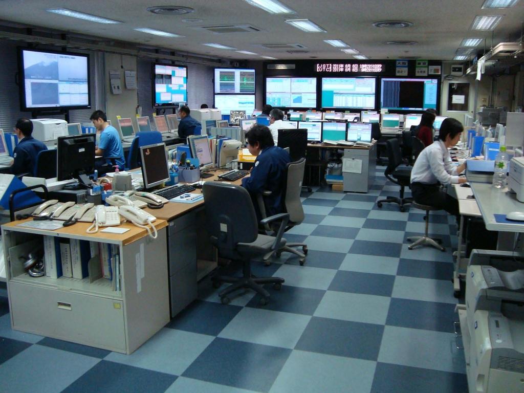
6 Earthquake Data Processing System Osaka Tokyo To process seismological data, and make and issue earthquake and tsunami information, JMA developed EPOS (Earthquake Phenomena Observations System). EPOS is located in Tokyo and Osaka. Tokyo-EPOS and Osaka-EPOS work in parallel, and function as back-up system one another.
7 7


8 Determination of Hypocenter and Magnitude The 2011 off the Pacific coast of Tohoku Earthquake For each station : P-phase arrival time S-phase arrival time Maximum amplitude
 6 (vertical direction, 0-100 km) 4 (magnitude) some")

9 Database for Tsunami Warning Preparation -- Create Tsunami Database distribution of assumed faults 1,500 (horizontal direction) 6 (vertical direction, km) 4 (magnitude) some mechanism = about 100,000 scenarios Calculate Crustal Movement for each Assumed Fault Arrival Time & Height Tsunami Database Tsunami Database Computer Simulation of Tsunami Propagation 9
 90degree (fixed) Dip angle is set which general tsunami most effectively. λ=0(strike-slip), 20 and 80 are also assumed.")
10 Fault Parameter and Tsunami Source Fault model - Reverse fault given by epicenter given by scaling law log L= 0.5M-1.9 (M:magnitude) W = L/2 logd = 0.5M-3.2 given in advance 45degree (fixed) 90degree (fixed) Dip angle is set which general tsunami most effectively. λ=0(strike-slip), 20 and 80 are also assumed. Tsunami source - Crustal deformation on the sea floor calculated by the elastic theory (Okada, 1985) - Initial tsunami height distribution is assumed to be same shape as the sea floor deformation

11 Strike Angle (φ) of the Assumed Faults Strike angle (degree)

12 Interpolation for Cases Far from the Shore Estimation of arrival time ---> choose the severest (earliest) case
13 Maximum Risk Method for Cases Close to the Shore Maximum risk method is used in case epicenter is near the coast. It is because starting point of the fault rupture cannot be known immediately. The maximum extent of the possible fault Light blue area is searched (whose centers are involved in a light orange area) L 5 D epicenter f(epicenter) = max{1,2,3,4,5} :Maximum Risk Method (Spacing between the hypothetical epicenters) where, logl = 0.5M 1.9
14 Estimation of Tsunami Height at the Coast Forecast Point (Height: H 1, Depth: h 1 ) Coastal Point (Height:H, Depth:h) Tsunami numerical simulation Application of Green s Law Forecast Point (H 1 h 1 ) Coastal Point (H h) H = 4 h h 1 H1 JMA substitute 1m for h
15 Tsunami Warning Classification Type of Tsunami Bulletin Tsunami Warning Major Tsunami Tsunami Tsunami Advisory Estimated Tsunami Height "3m", "4m", "6m", "8m", "over 10m" "1m", "2m" "0.5m" 66 Regional Blocks for Tsunami Warning/Advisory


,")

, ERI (2),")


16 Tsunami Monitoring Network in Japan : Tide Gauges(on the coast) JMA (77), Others(95) : GPS Buoy : Tsunameter JMA (6), ERI (2), JAMSTEC (4) Total: Tsunameter data is under evaluation (12/05/2011) Tide Gauges GPS Buoy Tsunameter


17 Dissemination of Tsunami Warning and Earthquake Information satellite Local Governments Loud Speakers Sirens Police, Fire offices Residents in coastal areas at risk Dedicated Telephone Line TV broadcasting On TV, radio, etc. JMA as the National Center Central Government Radio Stations etc.

 Information Exchange Global Seismic")


 NWPTA: Northwest Pacific")

18 Provision of Tsunami Bulletins to countries around the Northwest Pacific and the Indian Ocean Japanese Seismic Network Pacific Tsunami Warning Center (PTWC) Information Exchange Global Seismic Network Tsunami Bulletins (NWPTA)*1 (TWI)*2 Indian Ocean Northwest Pacific Ocean Sea Level Stations Data JMA Analysis Hypocenter Magnitude Evaluation of Tsunamigenic Potential Tsunami Observation etc. Contribute to the mitigation of tsunami disasters of countries around the Northwest Pacific and the Indian Oceans *1) NWPTA: Northwest Pacific Tsunami Advisory *2) TWI: Tsunami Watch Information for the Indian Ocean
19 EEW
 at numbers of cities, towns and villages. 2 An EEW is provided a few seconds to a few tens of seconds before the S-wave or strong tremor arrival.")
20 Concept of Earthquake Early Warning (EEW) 1 The EEW System automatically calculates the earthquake epicenter and magnitude from the P-waves detected near the epicenter, then estimates the strengths of following ground shaking (seismic intensities) at numbers of cities, towns and villages. 2 An EEW is provided a few seconds to a few tens of seconds before the S-wave or strong tremor arrival. Strong tremors may hit areas close to the earthquake focus at the same time as the Earthquake Early Warning.
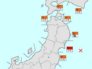
21 Seismic Intensity Information 21

22 JMA Seismic Intensity Scale 5 lower 5 upper 6 lower 6 upper 22

 Seismic Intensity")
23 Seismic Intensity (1) Network of Seismic Intensity Meter :JMA :Local Government -- 2,844 :NIED Total: 4,250 (2010/07/01) Seismic Intensity Meter 23
24 Emergency Operation Triggered by Seismic Intensity Information 1.5min EQ. Seismic Intensity Information Cabinet Secretariat Call of an urgent gathering team 6lower Cabinet Office Estimation of damages 4 3min Tsunami Warning Ministry of Defense Japan Coast Guard Investigation of damages 5lower Investigation of damages 5lower 5min Earthquake Information Metropolitan Police Department, Fire and Disaster Management Agency 4 Investigation of damages NHK a broadcasting company 3 Announcement by TV or Radio 24

 Distribution of Seismic")
25 Shake Map The Iwate-Miyagi Nairiku Earthquake in 2008 M:7.2 Depth : 8km Distribution of Seismic Intensity (observed point data) Distribution of Seismic Intensity (plane value estimated from observed data) 25
JMA Tsunami Warning Services. Takeshi KOIZUMI Senior Coordinator for International Earthquake and Tsunami Information Japan Meteorological Agency
 JMA Tsunami Warning Services Takeshi KOIZUMI Senior Coordinator for International Earthquake and Tsunami Information Japan Meteorological Agency Tectonic Setting of Japan (Headquarters for Earthquake Research
Seismic Activity and Crustal Deformation after the 2011 Off the Pacific Coast of Tohoku Earthquake
 J-RAPID Symposium March 6-7, 2013 Seismic Activity and Crustal Deformation after the 2011 Off the Pacific Coast of Tohoku Earthquake Y. Honkura Tokyo Institute of Technology Japan Science and Technology
- Information before strong ground motion -
 -Earthquake Early Warning - Information before strong ground motion - Mitsuyuki HOSHIBA Japan Meteorological Agency January 12, 2007 1 Distribution of Earthquakes Causing Tsunami (1896~2004) in Japan Distribution
Disclaimer. This report was compiled by an ADRC visiting researcher (VR) from ADRC member countries.
 from ADRC member countries.") Disclaimer This report was compiled by an ADRC visiting researcher (VR) from ADRC member countries. The views expressed in the report do not necessarily reflect the views of the ADRC. The boundaries and
Disclaimer This report was compiled by an ADRC visiting researcher (VR) from ADRC member countries. The views expressed in the report do not necessarily reflect the views of the ADRC. The boundaries and
Establishment and Operation of a Regional Tsunami Warning Centre
 Establishment and Operation of a Regional Tsunami Warning Centre Dr. Charles McCreery, Director NOAA Richard H. Hagemeyer Pacific Tsunami Warning Center Ewa Beach, Hawaii USA Why A Regional Tsunami Warning
Lessons Learned from Past Tsunamis Warning and Emergency Response
 UNESCO IOC CTIC US NOAA ITIC Regional Training Workshop on Strengthening Tsunami Warning and Emergency Response Standard Operating Procedures and the Development of the ICG/CARIBE-EWS PTWC New Enhanced
NUMERICAL SIMULATIONS FOR TSUNAMI FORECASTING AT PADANG CITY USING OFFSHORE TSUNAMI SENSORS
 NUMERICAL SIMULATIONS FOR TSUNAMI FORECASTING AT PADANG CITY USING OFFSHORE TSUNAMI SENSORS Setyoajie Prayoedhie Supervisor: Yushiro FUJII MEE10518 Bunichiro SHIBAZAKI ABSTRACT We conducted numerical simulations
Lessons from the 2004 Sumatra earthquake and the Asian tsunami
 Lessons from the 2004 Sumatra earthquake and the Asian tsunami Kenji Satake National Institute of Advanced Industrial Science and Technology Outline 1. The largest earthquake in the last 40 years 2. Tsunami
Making the Original Earthquake Early Warning System including epicentral earthquake
 Making the Original Earthquake Early Warning System including epicentral earthquake Protecting your life and minimizing damage. TEL: 0742-53-7833 4F, Oshikuma-cho 557-7, Nara-City 631-0011, Japan URL http://www.jjjnet.com
Earthquake Source. Kazuki Koketsu. Special Session: Great East Japan (Tohoku) Earthquake. Earthquake Research Institute, University of Tokyo
 Earthquake. Earthquake Research Institute, University of Tokyo") 2012/9/24 17:20-17:35 WCEE SS24.4 Special Session: Great East Japan (Tohoku) Earthquake Earthquake Source Kazuki Koketsu Earthquake Research Institute, University of Tokyo 1 Names and features of the earthquake
2012/9/24 17:20-17:35 WCEE SS24.4 Special Session: Great East Japan (Tohoku) Earthquake Earthquake Source Kazuki Koketsu Earthquake Research Institute, University of Tokyo 1 Names and features of the earthquake
Earthquakes and Tsunamis
 Earthquakes and Tsunamis Kenji Satake Earthquake Research Institute University of Tokyo 1 Part I 2011 Tohoku earthquake and tsunami 2 Fukushima Dai ichi NPP accident Earthquake ground motion Reactors automatically
STUDY ON TSUNAMIGENIC EARTHQUAKE CRITERIA FOR THE INDONESIAN TSUNAMI EARLY WARNING SYSTEM
 STUDY ON TSUNAMIGENIC EARTHQUAKE CRITERIA FOR THE INDONESIAN TSUNAMI EARLY WARNING SYSTEM Nanang T. Puspito 1 1 Geophysics Research Group, Faculty of Mining and Petroleum Engineering, Institute of Technology
Indian Ocean Tsunami Warning System: Example from the 12 th September 2007 Tsunami
 Indian Ocean Tsunami Warning System: Example from the 12 th September 2007 Tsunami Charitha Pattiaratchi 1 Professor of Coastal Oceanography, The University of Western Australia Email: chari.pattiaratchi@uwa.edu.au
Earthquakes and Tsunamis
 Earthquakes and Tsunamis Disaster prevention and mitigation efforts Japan Meteorological Agency Introduction Introduction Japan an earthquake-prone country Earthquake/Tsunami Monitoring and Flow of Warnings/Information
Tsunami Response and the Enhance PTWC Alerts
 Tsunami Response and the Enhance PTWC Alerts Ken Gledhill GeoNet Project Director Chair, Intergovernmental Coordination Group, Pacific Tsunami Warning and Mitigation System (PTWS) Overview 1. Procedures
Outline of Guideline for Development and Utilization of Tsunami Disaster Management Map
 Outline of Guideline for Development and Utilization of Tsunami Disaster Management Map Port and Airport Research Institute, Japan The Overseas Coastal Area Development Institute of Japan Ports and Harbours
Disaster Prevention Information Provided by Japan Meteorological Agency -- Our perspective to XML and CAP --
 Disaster Prevention Information Provided by Japan Meteorological Agency -- Our perspective to XML and CAP -- Kenichi Kuma Counsellor, Administration Department Japan Meteorological Agency (JMA) 1 Today
THE 2011 TOHOKU EARTHQUAKE IN JAPAN. VSU Lyuben Karavelov, Sofia, Bulgaria. Key words: Tohoku earthquake, strong ground motion, damage
 THE 2011 TOHOKU EARTHQUAKE IN JAPAN Radan Ivanov 1 VSU Lyuben Karavelov, Sofia, Bulgaria Abstract: This earthquake which occurred on March 11, 2011, had a magnitude of 9.0, which places it as the fourth
The great earthquakes that have shaped Japan 日本に大きな影響を与えた地震
 The great earthquakes that have shaped Japan 日本に大きな影響を与えた地震 Brian Kennett, Research School of Earth Sciences, ANU Takashi Furumura Earthquake Research Institute, University of Tokyo Japan tectonic plates
TSUNAMI CHARACTERISTICS OF OUTER-RISE EARTHQUAKES ALONG THE PACIFIC COAST OF NICARAGUA - A CASE STUDY FOR THE 2016 NICARAGUA EVENT-
 TSUNAMI CHARACTERISTICS OF OUTER-RISE EARTHQUAKES ALONG THE PACIFIC COAST OF NICARAGUA - A CASE STUDY FOR THE 2016 NICARAGUA EVENT- Amilcar Cabrera Supervisor: Yuichiro TANIOKA MEE16718 ABSTRACT Nicaragua
Status and Challenges on Geo-DRM Information Systems in Tonga
 Name: Mafua- i-vai utukakau Maka Status and Challenges on Geo-DRM Information Systems in Tonga 1 Roles and Relationships Land and Geographic Information Systems (LGIS) Unit: Establish updated high-resolution
Preparation for Future Earthquake and Tsunami Hazards: Lessons Learned from the 2004 Sumatra-Andaman Earthquake and the Asian Tsunami
 First International Conference of Aceh and Indian Ocean Studies Organized by Asia Research Institute, National University of Singapore & Rehabilitation and Construction Executing Agency for Aceh and Nias
How GNSS CORS in Japan works for geodetic control and disaster mitigations
 ICG Working Group D Reference Frames, Timing and Applications How GNSS CORS in Japan works for geodetic control and disaster mitigations ICG11, Nov. 7-11, 2016, Sochi, Russia Hiromichi TSUJI Geodetic Observation
Training System and Information Network for Earthquake Disaster Mitigation. Taiki SAITO. Building Research Institute (BRI)
") 1 Training System and Information Network for Earthquake Disaster Mitigation Taiki SAITO Chief Research Engineer, International Institute of Seismology and Earthquake Engineering (IISEE), Building Research
1 Training System and Information Network for Earthquake Disaster Mitigation Taiki SAITO Chief Research Engineer, International Institute of Seismology and Earthquake Engineering (IISEE), Building Research
History of International Training in Seismology and Earthquake Engineering at IISEE
 History of International Training in Seismology and Earthquake Engineering at IISEE Activities of International Institute of Seismology and Earthquake Engineering (IISEE), BRI - Training for young researchers/engineers
Investigation of mechanisms causing ground motion and tsunami due to the 2011 Tohoku Earthquake at Nuclear Power Plant sites
 Investigation of mechanisms causing ground motion and tsunami due to the 211 Tohoku Earthquake at Nuclear Power Plant sites Hideharu Sugino, Yoko Iwabuchi, Katsumi Ebisawa Japan Nuclear Energy Safety Organization
Real Time Monitoring System for Megathrust Earthquakes and Tsunamis - Cabled Network System and Buoy System in Japan -
 Real Time Monitoring System for Megathrust Earthquakes and Tsunamis - Cabled Network System and Buoy System in Japan - 1 Subduction zones around the world Haiti Italy Turkey Tohoku Sichuan Taiwan Sumatra
Formulation of the Strategy for Disaster Risk Reduction and Emergency Preparedness and Response of the Asia-Pacific Region
 2008/SOM3/TFEP/SEM/006 Formulation of the Strategy for Disaster Risk Reduction and Emergency Preparedness and Response of the Asia-Pacific Region 2009-2015 Submitted by: Thailand Emergency Management CEOs
JMA/WMO WORKSHOP ON EFFECTIVE TROPICAL CYCLONE WARNING IN SOUTHEAST ASIA
 JMA/WMO WORKSHOP ON EFFECTIVE TROPICAL CYCLONE WARNING IN SOUTHEAST ASIA TROPICAL CYCLONE MONITORING IN LAO PDR TOKYO, JAPAN 11 14 March 2014 Ministry of Natural Resource and Environment (MONRE) Department
Outline of the 2011 off the Pacific coast of Tohoku Earthquake (M w 9.0) Earthquake Early Warning and observed seismic intensity
 Earthquake Early Warning and observed seismic intensity") LETTER Earth Planets Space, 63, 547 551, 2011 Outline of the 2011 off the Pacific coast of Tohoku Earthquake (M w 9.0) Earthquake Early Warning and observed seismic intensity Mitsuyuki Hoshiba 1, Kazuhiro
LETTER Earth Planets Space, 63, 547 551, 2011 Outline of the 2011 off the Pacific coast of Tohoku Earthquake (M w 9.0) Earthquake Early Warning and observed seismic intensity Mitsuyuki Hoshiba 1, Kazuhiro
NUMERICAL SIMULATION AS GUIDANCE IN MAKING TSUNAMI HAZARD MAP FOR LABUAN ISLAND
 NUMERICAL SIMULATION AS GUIDANCE IN MAKING TSUNAMI HAZARD MAP FOR LABUAN ISLAND MOHD RIDZUAN bin Adam Supervisor: Fumihiko IMAMURA MEE09199 ABSTRACT At the northeast end of the South China Sea, tsunamis
Estimation of extended source area from vertical PGA saturation during a great earthquake for upgrading the EEW system
 Estimation of extended source area from vertical PGA saturation during a great for upgrading the EEW system S. Kurahashi & K. Irikura Aichi Institute of Technology SUMMARY: The present JMA Earthquake Early
The Current Activities of the Headquarters for Earthquake Research Promotion Concerning Tonankai/Nankai Earthquakes
 The Current Activities of the Headquarters for Earthquake Research Promotion Concerning Tonankai/Nankai Earthquakes ISOGAI Keisuke Director of Earthquake Research Division, Research and Development Bureau,
Tsunami Warning Center SOPs Concept of Operations, Overview of Routine and Event Operations, Flow Charts, Timelines and Checklists
 Tsunami Warning Center SOPs Concept of Operations, Overview of Routine and Event Operations, Flow Charts, Timelines and Checklists Masahiro Yamamoto UNESCO IOC Laura Kong Director International Tsunami
Mechanism of tsunami generation,propagation and runup -sharing experiences with Japanese
 Mechanism of tsunami generation,propagation and runup -sharing experiences with Japanese Mechanism of tsunami generation Predicting the propagation, runup and inundation of tsunamis Near and far-field
REAL-TIME TSUNAMI INUNDATION PREDICTION USING OFFSHORE TSUNAMI OBSERVATION. Daisuke TATSUMI 1 and Takashi TOMITA 1
 REAL-TIME TSUNAMI INUNDATION PREDICTION USING OFFSHORE TSUNAMI OBSERVATION Daisuke TATSUMI and Takashi TOMITA The previous real-time tsunami prediction based on the inversion method and the linear superposition
Source modeling of hypothetical Tokai-Tonankai-Nankai, Japan, earthquake and strong ground motion simulation using the empirical Green s functions
 Source modeling of hypothetical Tokai-Tonankai-Nankai, Japan, earthquake and strong ground motion simulation using the empirical Green s functions Y. Ishii & K. Dan Ohsaki Research Institute, Inc., Tokyo
Special feature: Are its lessons being adequately applied? Follow-up on the ten-year anniversary of the Hanshin-Awaji Earthquake
 Special feature: Are its lessons being adequately applied? Follow-up on the ten-year anniversary of the Hanshin-Awaji Earthquake - Are we prepared for future massive earthquakes? - Hisakazu SAKAI Member
Coseismic slip model
 Figure 3 - Preliminary highly smoothed model of coseismic slip for the 11 March UCL Institute for Risk & Disaster Reduction Magnitude 9.0 (JMA scale) earthquake Occurred at 02:46:23 pm local time near
Status after Six Years
 German-Indonesian Tsunami Early Warning System () Status after Six Years Joern Lauterjung and the -Team Challenge Indonesia Short Early Warning Time Tsunamis are generated at the trench (orange line) Traveltimes
Low-Latency Earthquake Displacement Fields for Tsunami Early Warning and Rapid Response Support
 Low-Latency Earthquake Displacement Fields for Tsunami Early Warning and Rapid Response Support Hans-Peter Plag, Geoffrey Blewitt Nevada Bureau of Mines and Geology and Seismological Laboratory University
(energy loss is greater with longer wavelengths)
") GEOL 0820 Ramsey Natural Disasters Spring, 2018 LECTURE #9: Tsunami Monitoring & Mitigation Date: 8 February 2018 I. Characteristics (con t): shoaling: o process of wave height increase and breaking as
GEOL 0820 Ramsey Natural Disasters Spring, 2018 LECTURE #9: Tsunami Monitoring & Mitigation Date: 8 February 2018 I. Characteristics (con t): shoaling: o process of wave height increase and breaking as
Earthquake Hazards. Tsunami
 Earthquake Hazards Tsunami Review: What is an earthquake? Earthquake is the vibration (shaking) and/or displacement of the ground produced by the sudden release of energy. The point inside the Earth where
METEOROLOGICAL WARNINGS STUDY GROUP (METWSG)
") METWSG/4-SN No. 6 12/3/12 METEOROLOGICAL WARNINGS STUDY GROUP (METWSG) FOURTH MEETING Montréal, 15 to 18 May 2012 Agenda Item 6: Wind shear, turbulence and tsunami warnings TSUNAMI INFORMATION (Presented
METWSG/4-SN No. 6 12/3/12 METEOROLOGICAL WARNINGS STUDY GROUP (METWSG) FOURTH MEETING Montréal, 15 to 18 May 2012 Agenda Item 6: Wind shear, turbulence and tsunami warnings TSUNAMI INFORMATION (Presented
ShakeAlert Earthquake Early Warning
 ShakeAlert Earthquake Early Warning Doug Given USGS, Pasadena Earthquake Program, Early Warning Coordinator 10 seconds 50 seconds 90 seconds USGS Earthquake Hazard Responsibilities USGS has the lead federal
Sri Lanka Enhancing the Role of ICTs for Disaster Risk Management
 Workshop on ICT for Promoting Inclusive and Disaster Resilient Development Ulaanbaatar, Mongolia Sri Lanka Enhancing the Role of ICTs for Disaster Risk Management Kanchana Thudugala Programme Head, eservices
Special edition paper Development of Shinkansen Earthquake Impact Assessment System
 Development of Shinkansen Earthquake Impact Assessment System Makoto Shimamura*, Keiichi Yamamura* Assuring safety during earthquakes is a very important task for the Shinkansen because the trains operate
Enhancing Preparedness and Early Warning in Disaster Risk Reduction
 Enhancing Preparedness and Early Warning in Disaster Risk Reduction Fifth Technical Conference on Management of Meteorological and Hydrological Services in Regional Association V at PETALING JAYA, MALAYSIA
Real time Monitoring System for Earthquakes and Tsunamis (DONET)
") Real time Monitoring System for Earthquakes and Tsunamis (DONET) NankaiTrough Yoshiyuki Kaneda Japan Agency for Marine-Earth Science and Technology (JAMSTEC) POGO@Seoul Presentation 1 Earthquakes in the
Real time Monitoring System for Earthquakes and Tsunamis (DONET) NankaiTrough Yoshiyuki Kaneda Japan Agency for Marine-Earth Science and Technology (JAMSTEC) POGO@Seoul Presentation 1 Earthquakes in the
The ITSU System in the Pacific Region and Future Upgrades
 The ITSU System in the Pacific Region and Future Upgrades Eddie Bernard Director, Pacific Marine Environmental Laboratory (PMEL) NOAA/USA Pacific Tsunami Warning Center OPERATIONAL ACTIVITIES SEISMIC DATA
Effect of the Emperor seamounts on trans-oceanic propagation of the 2006 Kuril Island earthquake tsunami
 GEOPHYSICAL RESEARCH LETTERS, VOL. 35, L02611, doi:10.1029/2007gl032129, 2008 Effect of the Emperor seamounts on trans-oceanic propagation of the 2006 Kuril Island earthquake tsunami S. Koshimura, 1 Y.
Blank line 10 pt Keywords: Response Characteristics, Skyscraper, Tohoku-Oki earthquake, Natural operiod
 A Study on the Response Characteristics of a High-Rise Building Built on the Reclaimed Land along the Osaka Bay Yuta Akizuki Graduate School of Engineering, Kyoto University, Kyoto, Japan Blank Line 9
ACTIVITIES OF THE HEADQUARTERS FOR EARTHQUAKE RESEARCH PROMOTION
 Journal of Japan Association for Earthquake Engineering, Vol.4, No.3 (Special Issue), 2004 ACTIVITIES OF THE HEADQUARTERS FOR EARTHQUAKE RESEARCH PROMOTION Sadanori HIGASHI 1 1 Member of JAEE, Earthquake
Crustal deformation by the Southeast-off Kii Peninsula Earthquake
 Crustal deformation by the Southeast-off Kii Peninsula Earthquake 51 Crustal deformation by the Southeast-off Kii Peninsula Earthquake Tetsuro IMAKIIRE, Shinzaburo OZAWA, Hiroshi YARAI, Takuya NISHIMURA
The international patterns of spatial planning system and choice of China. Cai yumei China land use planning and surveying institute (China, beijing)
") FIG Working Week, Rome, Italy 6 10 May 2012 The international patterns of spatial system and choice of China Cai yumei China land use and surveying institute (China, beijing) Outline Background Problem
FIG Working Week, Rome, Italy 6 10 May 2012 The international patterns of spatial system and choice of China Cai yumei China land use and surveying institute (China, beijing) Outline Background Problem
Earthquake Hazards. Tsunami
 Earthquake Hazards Tsunami Measuring Earthquakes Two measurements that describe the power or strength of an earthquake are: Intensity a measure of the degree of earthquake shaking at a given locale based
Purpose of the seminar
 Earthquake disaster preparedness June 24, 2008 Koshun Yamaoka Research Center for Seismology, Volcanology and Disaster Mitigation Graduate School of Environmental Studies Nagoya University Purpose of the
THEORETICAL EVALUATION OF EFFECTS OF SEA ON SEISMIC GROUND MOTION
 13 th World Conference on Earthquake Engineering Vancouver, B.C., Canada August 1-6, 2004 Paper No. 3229 THEORETICAL EVALUATION OF EFFECTS OF SEA ON SEISMIC GROUND MOTION Ken HATAYAMA 1 SUMMARY I evaluated
Earthquakes and Earthquake Hazards Earth - Chapter 11 Stan Hatfield Southwestern Illinois College
 Earthquakes and Earthquake Hazards Earth - Chapter 11 Stan Hatfield Southwestern Illinois College What Is an Earthquake? An earthquake is the vibration of Earth, produced by the rapid release of energy.
Introduction to Environmental Geology, 5e Case History: Indonesian Tsunami Indonesian Tsunami (2) Introduction Historic Tsunamis
 Introduction Historic Tsunamis") 1 2 3 4 5 6 7 8 9 Introduction to Environmental Geology, 5e Chapter 7 Tsunami Case History: Indonesian Tsunami December 26, 2004, within a few hours, close to 250,000 people were killed With no warning
1 2 3 4 5 6 7 8 9 Introduction to Environmental Geology, 5e Chapter 7 Tsunami Case History: Indonesian Tsunami December 26, 2004, within a few hours, close to 250,000 people were killed With no warning
A PROTOTYPE OF WEB-APPLICATION FOR TSUNAMI DATABASE ALONG SOUTHERN JAVA ISLAND COASTLINE
 A PROTOTYPE OF WEB-APPLICATION FOR TSUNAMI DATABASE ALONG SOUTHERN JAVA ISLAND COASTLINE Ariska Rudyanto MEE07170 Supervisor: Yohei HASEGAWA Yosuke IGARASHI Yushiro FUJII ABSTRACT Development of tsunami
Earthquake Hazards. Tsunami
 Earthquake Hazards Tsunami Review: What is an earthquake? Earthquake is the vibration (shaking) and/or displacement of the ground produced by the sudden release of energy. The point inside the Earth where
SOP of PTWC as a Regional Tsunami Service Provider
 UNESCO IOC CTIC US NOAA ITIC Regional Training Workshop on Strengthening Tsunami Warning and Emergency Response Standard Operating Procedures and the Development of the ICG/CARIBE-EWS PTWC New Enhanced
中村洋光 Hiromitsu Nakamura 防災科学技術研究所 National Research Institute for Earth Science and Disaster Prevention, Japan (NIED) Outline
 Outline") Earthquake Early Warning in Japan 中村洋光 Hiromitsu Nakamura 防災科学技術研究所 National Research Institute for Earth Science and Disaster Prevention, Japan (NIED) Outline Overview of the earthquake early warning
Earthquake Early Warning in Japan 中村洋光 Hiromitsu Nakamura 防災科学技術研究所 National Research Institute for Earth Science and Disaster Prevention, Japan (NIED) Outline Overview of the earthquake early warning
STRATEGY FOR TAKING FULL ADVANTAGE OF EARTHQUAKE EARLY WARNING SYSTEM FOR EARTHQUAKE DISASTER REDUCTION
 ABSTRACT : STRATEGY FOR TAKING FULL ADVANTAGE OF EARTHQUAKE EARLY WARNING SYSTEM FOR EARTHQUAKE DISASTER REDUCTION K. Meguro 1 1 Director/Professor, International Center for Urban Safety Engineering, Institute
Recent Progress of Seismic Observation Networks in Japan
 Journal of Physics: Conference Series Recent Progress of Seismic Observation Networks in Japan To cite this article: Y Okada 2013 J. Phys.: Conf. Ser. 433 012039 Related content - Physical applications
Earthquakes Chapter 19
 Earthquakes Chapter 19 Does not contain complete lecture notes. What is an earthquake An earthquake is the vibration of Earth produced by the rapid release of energy Energy released radiates in all directions
Masato MOTOSAKA. Introduction of Earthquake Early Warning at Schools
 Masato MOTOSAKA Introduction of Earthquake Early Warning at Schools 15 Self-introduction ~Recent activities Invited lecture regarding development of EEW/SHM system - USC, California,2009 -AGU conference,
Introduction to Environmental Geology, 5e
 Lecture Presentation prepared by X. Mara Chen, Salisbury University Introduction to Environmental Geology, 5e Edward A. Keller Chapter 7 Tsunami Case History: Indonesian Tsunami December 26, 2004, within
Earthquakes. Building Earth s Surface, Part 2. Science 330 Summer What is an earthquake?
 Earthquakes Building Earth s Surface, Part 2 Science 330 Summer 2005 What is an earthquake? An earthquake is the vibration of Earth produced by the rapid release of energy Energy released radiates in all
TWC Operations Challenges and Limitations
 UNESCO IOC CTIC US NOAA ITIC Regional Training Workshop on Strengthening Tsunami Warning and Emergency Response Standard Operating Procedures and the Development of the ICG/CARIBE-EWS PTWC New Enhanced
KNOWLEDGE NOTE 5-1. Risk Assessment and Hazard Mapping. CLUSTER 5: Hazard and Risk Information and Decision Making. Public Disclosure Authorized
 Public Disclosure Authorized Public Disclosure Authorized Public Disclosure Authorized Public Disclosure Authorized KNOWLEDGE NOTE 5-1 CLUSTER 5: Hazard and Risk Information and Decision Making Risk Assessment
SCIENCE OF TSUNAMI HAZARDS
 SCIENCE OF TSUNAMI HAZARDS ISSN 8755-6839 Journal of Tsunami Society International Volume 31 Number 4 2012 RESPONSE OF THE GDACS SYSTEM TO THE TOHOKU EARTHQUAKE AND TSUNAMI OF 11 MARCH 2011 Annunziato,
Title. Author(s)Heki, Kosuke. CitationScience, 332(6036): Issue Date Doc URL. Type. File Information. A Tale of Two Earthquakes
Heki, Kosuke. CitationScience, 332(6036): Issue Date Doc URL. Type. File Information. A Tale of Two Earthquakes") Title A Tale of Two Earthquakes Author(s)Heki, Kosuke CitationScience, 332(6036): 1390-1391 Issue Date 2011-06-17 Doc URL http://hdl.handle.net/2115/48524 Type article (author version) File Information
Title A Tale of Two Earthquakes Author(s)Heki, Kosuke CitationScience, 332(6036): 1390-1391 Issue Date 2011-06-17 Doc URL http://hdl.handle.net/2115/48524 Type article (author version) File Information
Earthquakes. Earthquake Magnitudes 10/1/2013. Environmental Geology Chapter 8 Earthquakes and Related Phenomena
 Environmental Geology Chapter 8 Earthquakes and Related Phenomena Fall 2013 Northridge 1994 Kobe 1995 Mexico City 1985 China 2008 Earthquakes Earthquake Magnitudes Earthquake Magnitudes Richter Magnitude
Earthquake Early Warning in Japan: Warning the General Public and Future Prospects
 Earthquake Early Warning in Japan: Warning the General Public and Future Prospects Osamu Kamigaichi, Makoto Saito, Keiji Doi, Toshiyuki Matsumori, Shin ya Tsukada, Kiyoshi Takeda, Toshihiro Shimoyama,
Tectonic Processes and Hazards Enquiry Question 1: Why are some locations more at risk from tectonic hazards?
 Tectonic Processes and Hazards Enquiry Question 1: Why are some locations more at risk from tectonic hazards? Key words Basalt Andesite Rhyolite Benioff Zone Subduction zone Crustal fracturing Definition
A Study on the Risk Assessment of Emergency Supplies. Transportation Routes Considering Scenario Earthquakes
 ORIGINAL ARTICLE A Study on the Risk Assessment of Emergency Supplies Transportation s Considering Scenario Earthquakes Kazuaki Torisawa 1, Harumi Yashiro 2, Sei ichiro Fukushima 3*, Satoshi Kina 4 1 Kajima
DEVASTATING DAMAGE DUE TO THE 2004 INDIAN OCEAN TSUNAMI AND ITS LESSONS
 DEVASTATING DAMAGE DUE TO THE 2004 INDIAN OCEAN TSUNAMI AND ITS LESSONS Fumihiko Imamura 1 1 Professor, Tsunami Engineering, Disaster Control Research Center, Tohoku University, Japan Email: imamura@tsunami2.civil.tohoku.ac.jp
Tsunami Waveform Inversion based on Oceanographic Radar Data
 Research Institute for Applied Mechanics Workshop of Oceanographic Radar 12-13 December 2012 1 Tsunami Waveform Inversion based on Oceanographic Radar Data Ryotaro Fuji 1), Hirofumi Hinata 1), Tomoyuki
New Tsunami Disaster Mitigation System considering Local Conditions of Indian Ocean Rim Regions
 New Tsunami Disaster Mitigation System considering Local Conditions of Indian Ocean Rim Regions Kimiro Meguro Professor, Institute of Industrial Science, The University of Tokyo, Japan Shunichi Koshimura
TEMPLATE FOR NATIONAL REPORTS. National Reports will be posted to the ICG/CARIBE EWS-XII web site without TWFP contact details
 IOC Circular Letter, 2661-1 TEMPLATE FOR NATIONAL REPORTS National Reports will be posted to the ICG/CARIBE EWS-XII web site without TWFP contact details BASIC INFORMATION PRELIMINAR NATIONAL REPORT Submitted
Annual Report for Research Work in the fiscal year 2005
 JST Basic Research Programs C R E S T (Core Research for Evolutional Science and Technology) Annual Report for Research Work in the fiscal year 2005 Research Area : High Performance Computing for Multi-scale
Case Study of Japan: Crustal deformation monitoring with GNSS and InSAR
 Technical Seminar Reference Frame in Practice, Case Study of Japan: Crustal deformation monitoring with GNSS and InSAR Basara Miyahara miyahara-b96ip@milt.go.jp Geospatial Information Authority of Japan
Figure Locations of the CWB free-field strong motion stations, the epicenter, and the surface fault of the 1999 Chi-Chi, Taiwan earthquake.
 2.2 Strong Ground Motion 2.2.1 Strong Ground Motion Network The world densest digital strong ground motion network of Taiwan with the station mesh of 3 km in the urban areas (Shin et al., 2) monitored
UGRC 144 Science and Technology in Our Lives/Geohazards
 UGRC 144 Science and Technology in Our Lives/Geohazards Session 3 Understanding Earthquakes and Earthquake Hazards Lecturer: Dr. Patrick Asamoah Sakyi Department of Earth Science, UG Contact Information:
Characteristics and introduction of Earthquake in Asia-Pacific region
 Characteristics and introduction of Earthquake in Asia-Pacific region 1906 San Francisco 2011 Tohoku 1999 Chi-Chi 1985 Mexico City 2004 Sumatra Chung-Han Chan 詹忠翰 2011 Christchurch To understand the characteristics
Tsunami Research and Its Practical Use for Hazard Mitigation. Hiroo Kanamori Seismological Laboratory, California Institute of Technology
 Tsunami Research and Its Practical Use for Hazard Mitigation Hiroo Kanamori Seismological Laboratory, California Institute of Technology Cause of Tsunami Earthquakes Landslides Volcanic origin Impact (Dr.
Data Sharing at the National Research Institute for Earth Science and Disaster Resilience
 Data Sharing at the National Research Institute for Earth Science and Disaster Resilience Katsuhiko SHIOMI Network Center for Earthquake, Tsunami and Volcano, NIED 2017.12.05 International workshop on
Ms. Latoya Regis. Meteorologist Hydrometeorological Service, Guyana
 Ms. Latoya Regis Meteorologist Hydrometeorological Service, Guyana Background Ninety percent (90%) of Guyana s population resides along the (Atlantic) Coast, which is below mean sea level and accounts
REAL-TIME ASSESSMENT OF EARTHQUAKE DISASTER IN YOKOHAMA BASED ON DENSE STRONG-MOTION NETWORK
 REAL-TIME ASSESSMENT OF EARTHQUAKE DISASTER IN YOKOHAMA BASED ON DENSE STRONG-MOTION NETWORK Saburoh MIDORIKAWA 1 And Susumu ABE 2 SUMMARY This paper describes a system for REal-time Assessment of earthquake
Earthquake,Tsunami,Volcano Monitoring & Warning System in Korea. Jimin Lee Earthquake & Volcano Monitoring Division KMA
 Earthquake,Tsunami,Volcano Monitoring & Warning System in Korea Jimin Lee Earthquake & Volcano Monitoring Division KMA 1 2 Brief History & Vision of KMA Introduction of Services 3 Korea National Seismographic
TSUNAMI HAZARD ASSESSMENT IN NORTHERN EGYPT USING NUMERICAL SIMULATION
 TSUNAMI HAZARD ASSESSMENT IN NORTHERN EGYPT USING NUMERICAL SIMULATION Abutaleb Ali Supervisor: Bunichiro SHIBAZAKI MEE16717 Yushiro FUJII ABSTRACT To investigate the tsunami hazard along the northern
apanese Nationwide Earthquake and Tsunami Observation Network Operated by NIED
 APEC Workshop on Application of Big Data and Open Data@Taipei Garden Hotel (2015/10/29-30) apanese Nationwide Earthquake and Tsunami Observation Network Operated by NIED Shin Aoi National Research Institute
What is an Earthquake?
 Earthquakes What is an Earthquake? Earthquake - sometimes violent shaking of ground caused by movement of Earth s tectonic plates; creates seismic waves Often followed by smaller earthquakes (aftershocks);
NUMERICAL SIMULATION OF TSUNAMI PROPAGATION AND INUNDATION ALONG THE RAKHINE COAST AREAS IN MYANMAR
 NUMERICAL SIMULATION OF TSUNAMI PROPAGATION AND INUNDATION ALONG THE RAKHINE COAST AREAS IN MYANMAR Su Hninn Htwe Supervisor: Bunichiro SHIBAZAKI MEE12619 Yushiro FUJII ABSTRACT This study aimed to assess
HISTORY OF HEAVY RAINFALL DISASTER INFORMATION IN JAPAN
 transmission, for a state-of-the-art review. In addition, issues expected to arise in the future are discussed. HISTORY OF HEAVY RAINFALL DISASTER INFORMATION IN JAPAN Progress of Rainfall Observation
Scaling relations of seismic moment, rupture area, average slip, and asperity size for M~9 subduction-zone earthquakes
 GEOPHYSICAL RESEARCH LETTERS, VOL. 4, 7 74, doi:1.12/grl.976, 213 Scaling relations of seismic moment, rupture area, average slip, and asperity size for M~9 subduction-zone earthquakes Satoko Murotani,
Georeferencing and Satellite Image Support: Lessons learned, Challenges and Opportunities
 Georeferencing and Satellite Image Support: Lessons learned, Challenges and Opportunities Shirish Ravan shirish.ravan@unoosa.org UN-SPIDER United Nations Office for Outer Space Affairs (UNOOSA) UN-SPIDER
Interviewing insights regarding the high fatality rate inflicted by the
 AIST 2012.2.23 Interviewing insights regarding the high fatality rate inflicted by the 2011 Tohoku earthquake a Masataka Ando, b Mizuho Ishida, c Yoshinari Hayashi d Chiharu Mizuki and e Yuka Nishikawa