Cascadia Seismic Event Planning for the Maritime Community
|
|
|
- Noel Lawson
- 5 years ago
- Views:
Transcription
1 Cascadia Seismic Event Planning for the Maritime Community Jonathan Allan, Oregon Dept. of Geology and Mineral Industries Presentation to Annual Pacific Northwest Waterways Association Meeting (PNWA) October 7th, 2015 Embassy Suites, Portland
2 Presentation Outline Introduce concept of local vs distant tsunami sources; Discuss recent Oregon mapping efforts, results and end products; What are we doing to address maritime safety in response to tsunami; Upcoming focused modeling and mapping efforts in the Columbia R.; and, Conclusion.

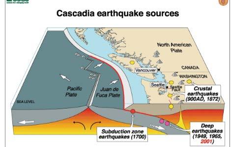
3 Cascadia Subduction Zone (CSZ) North American Plate Overrides Juan de Fuca Plate Along Cascadia Subduction Zone at a rate of 1.5 inches/year

4 Using paleoseismology as the foundation for tsunami modeling 10,000 year record of deep sea turbidites Coastal evidence of coseismic subsidence and tsunami inundation Tsunami deposits in Oregon estuaries and coastal lakes

5 A 10,000 year history of ~40 great Cascadia earthquakes in Oregon The last big Cascadia earthquake and local tsunami in the Northwest was January 26, 1700 at ~9:00 PM. (Satake et al., 2003, Journ. Geophys. Res., v 108, no. B11, p )
6 Subduction Zone Fault Slip Displaces the Pacific

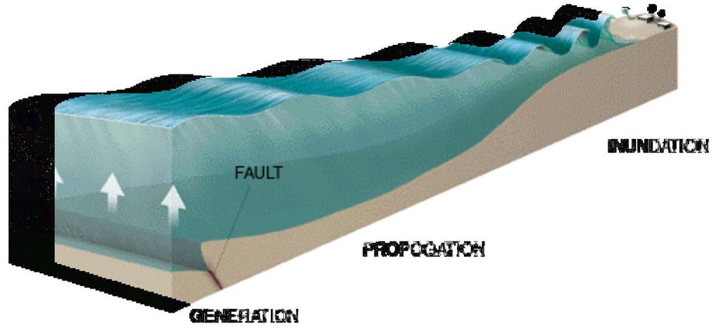
7 Tsunami genesis Courtesy Professor Miho Aoki, University of Alaska-Fairbanks Art Department, University of Alaska-Fairbanks

8 Tsunamis are NOT like wind waves Wind waves break on shore in a few seconds Tsunamis are a higher ocean surface that just keeps coming for tens of minutes

9 WHERE DO OREGON TSUNAMIS COME FROM? Subduction Zones (blue lines). Local Oregon Tsunamis Distant Tsunamis LSAC Meeting, Newport 2015
10 Distant vs Local Tsunami Distant: Arrives 4 + hours after the earthquake Lower damage and flooding than local tsunamis National Tsunami Warning System can warn you Local Tsunami: Arrives minutes after the earthquake Much higher waves Much further inland penetration NOAA Tsunami Warning System ineffective Earthquake = Only Warning


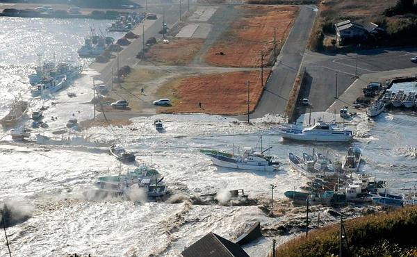
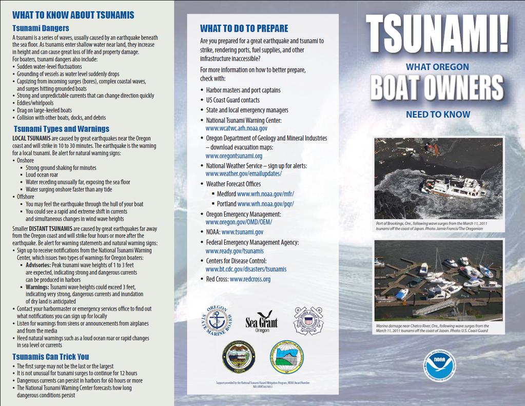
11 Tohoku, Japan, March 11, 2011 The tsunami, seen crashing into homes in Natori, Miyagi prefecture. AP AP Disaster Management Building


12 Oregon Tsunami Inundation Hazard Team Acknowledgments: Rob Witter Joseph Zhang Kelin Wang Chris Goldfinger George Priest Laura Stimely
 = 95% of local tsunamis (~2500-yr event) SB 379 (approximately) = 79% of local tsunamis (~500-yr")
13 Qualitative Explanation of Cascadia Tsunami Scenarios shown on published tsunami inundation maps (TIMs) = 100% of local tsunamis (~5000-yr event) Local Tsunami Evacuation Zone for Oregon = 98% of local tsunamis (~5000-yr event) = 95% of local tsunamis (~2500-yr event) SB 379 (approximately) = 79% of local tsunamis (~500-yr event)

14 Summary: Cascadia Tsunami Scenarios Paleoseismology constrains results Cascadia earthquakes: M w 8.7 to M w 9.2 Coseismic slip range: 9 to 44 m Tsunami runup: 4 to >25 m Max shoreline wave amplitude: 4 to >25 m Inundation distance: 1 to >3 km Tsunami arrival: 15 to 20 minutes Tsunami Inundation Map (TIM)
15 STATEWIDE DISTANT TSUNAMI SCENARIOS AK64: Largest historical tsunami (1964 Mw 9.2 earthquake in Gulf of Alaska) AKmax: Maximum-considered tsunami (Hypothetical Mw 9.2 earthquake in Gulf of Alaska)

16 AKmax = Distant Tsunami Evacuation Zone for Oregon Has maximum directivity to the Oregon coast. (Source 3 illustration from Tsunami Pilot Study Working Group (2006))
17 27 fathoms (164 ft) Shoreline Tsunami Height is Strongly Affected by Bathymetry Designing for Tsunamis
18 Open coast XXL1 mean = 62 ft
19
20

21
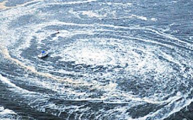
22 Maritime Tsunami Dangers High velocity currents that tear up port facilities and tethered vessels Wind wave amplification by tsunami currents Rapidly reversing velocity Minimum flow depth (grounding of vessels) Debris field from withdrawing tsunamis & currents Tsunami wave steepness (only very close to shore) Vorticity (whirlpools)

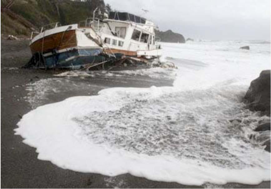
23 Crescent City Near Brookings, Oregonian
24 Thresholds Vorticity, Minimum Flow Depth, Velocity, Wind Wave Amplification Velocity threshold >3 knots Large amplification of PNW wind waves in open ocean Damaging to port facilities in estuaries Minimum flow depth for grounding vessels <50 ft for statewide guidance Could be much less for estuaries with only smaller vessels Threshold vorticity >0.1 for very strong shear Could be as low as >0.01 for any shear
 modified from Lynett and others (2014) 3-KNOT")
25 PORT DAMAGE vs TSUNAMI CURRENT VELOCITY (NTHMP Mapping and Modeling Subcommittee (2014) modified from Lynett and others (2014) 3-KNOT THRESHOLD
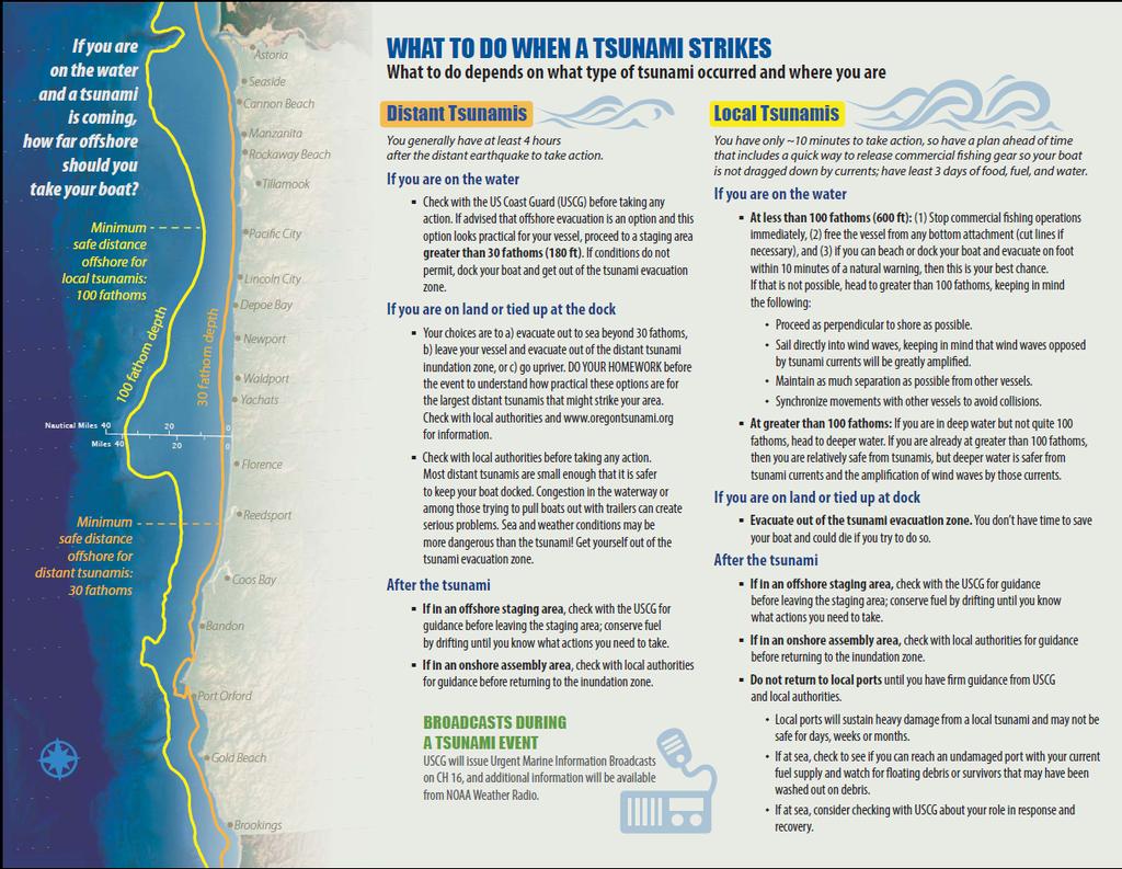
26 STATEWIDE MARITIME GUIDANCE Distant Tsunamis Warning: NOAA broadcasts 4 hours to take action Offshore: go to >30 fathoms; Guidance during event: USCG Tied to dock: Check with local officials Explore options in advance (e.g. go upriver? Out to sea?) On Land: Go to evacuation site Wait until local officials say it is safe to return. Local Tsunamis Warning: Ground shaking Ocean roar Water receding or surging 10 minutes to take action Offshore: go to >100 fathoms; Guidance during event: USCG Tied to dock or on land: Go to evacuation site Wait until local officials say it is safe to return. Plan to be out to sea for days with nearby ports out of commission (fuel, food, etc.).
27
28
29 Newport-Toledo Maritime Guidance for Distant Tsunamis Guidance is for distant tsunamis, because there are more options for these smaller tsunamis than for local tsunamis which arrive in tens of minutes after the earthquake and always destroy or heavily damage port assets. Process: Organize Local Tsunami Advisory Committee (LSAC) Present key tsunami hazard data Formulate straw man guidance options LSAC reviews and then meets to decide
30
31 Major Damage to Complete Destruction Moderate to Major Damage Minor to Moderate Damage Time history data is from Oregon Department of Geology and Mineral Industries Open-File Report O-13-16, observation Station 81, Grid B.
32
 7.6 ft NAVD88 LSAC Meeting, Newport 2015")
33 Threshold Assumed tide = MHHW (mean higher high water) 7.6 ft NAVD88 LSAC Meeting, Newport 2015

34 LSAC Meeting, Newport 2015
35 Summary Cascadia will be devastating for the PNW; Coastal communities will be isolated and likely will have to survive for a number of weeks on few supplies; Ports and harbors will be destroyed, and many estuaries (including critical navigational channels) will likely be filled with debris and impassable; Jetties will likely be destroyed and controlled entrances will be free to migrate again; For a distant tsunami, and time permitting, mariners may choose to evacuate to deep water (30 fathom line); For a local tsunami, there is no time to evacuate from ports; and, Vessels already out on the ocean should evacuate to either the 30 fathom line (distant event) or 100 fathom line for a local tsunami.
RECENT COMPREHENSIVE TSUNAMI MODELING FOR COASTAL OREGON
 RECENT COMPREHENSIVE TSUNAMI MODELING FOR COASTAL OREGON Speaker: George R. Priest, Oregon Dept. of Geology and Mineral Industries Pardee Keynote Symposium Great Earthquakes, the Cascadia Subduction Zone,
New Oregon Tsunami Simulation Scenarios, Published Data, and Probable Effect on the Oregon Building Code
 New Oregon Tsunami Simulation Scenarios, Published Data, and Probable Effect on the Oregon Building Code George R. Priest, Oregon Dept. of Geology and Mineral Industries Presentation to the workshop on
What is a tsunami? Capital Regional District Tsunami Frequently Asked Questions (FAQ s) Tsunami (soo-nah-mee)
 Tsunami (soo-nah-mee)") Tsunami (soo-nah-mee) Tsunamis (Japanese translation harbour wave ) are waves with a great distance between crests, and are caused by any widespread, sudden movement of large volumes of water. The tsunami
Tsunami (soo-nah-mee) Tsunamis (Japanese translation harbour wave ) are waves with a great distance between crests, and are caused by any widespread, sudden movement of large volumes of water. The tsunami
Tsunami potential and modeling
 Tsunami potential and modeling GEORGE PRIEST OREGON DEPT. OF GEOLOGY AND MINERAL INDUSTRIES NEWPORT COASTAL FIELD OFFICE April 7, 2012 GeoPRISMS Cascadia Workshop, Portland, Oregon What creates most uncertainty
Tsunami Hazard Map of the Warrenton Area, Clatsop County, Oregon
 CEDAR Lewis STATE OF OREGON DEPARTMENT OF GEOLOGY AND MINERAL INDUSTRIES DONALD A. HULL, STATE GEOLOGIST 124 Tsunami Hazard Map of the Warrenton Area, Clatsop County, Oregon 1999 MAP EXPLANATION (see accompanying
OREGON DEPARTMENT OF GEOLOGY & MINERAL INDUSTRIES
 OREGON DEPARTMENT OF GEOLOGY & MINERAL INDUSTRIES Mission: Provide Earth Science Information To Make Oregon Safe and Prosperous EARTHQUAKES & TSUNAMIS S Lidar Earthquake/Tsunami Science Educate & Mitigate
DRAFT - Tsunami Response Plan Playbook Santa Cruz Harbor Maritime Community
 DRAFT - Tsunami Response Plan Playbook Santa Cruz Harbor Maritime Community Page 1 Best to display on 11X17 paper Purpose and Use of this Real-time Tsunami Response Plan Playbook PURPOSE: This product
Surviving the Big One: Understanding and Preparing for a Major Earthquake in Western Oregon
 Surviving the Big One: Understanding and Preparing for a Major Earthquake in Western Oregon May 21, 2013 City of Salem Salem Public Library Althea Rizzo, Geological Hazards Program Coordinator Oregon Emergency
Earthquakes and Tsunamis
 Earthquakes and Tsunamis Kenji Satake Earthquake Research Institute University of Tokyo 1 Part I 2011 Tohoku earthquake and tsunami 2 Fukushima Dai ichi NPP accident Earthquake ground motion Reactors automatically
(energy loss is greater with longer wavelengths)
") GEOL 0820 Ramsey Natural Disasters Spring, 2018 LECTURE #9: Tsunami Monitoring & Mitigation Date: 8 February 2018 I. Characteristics (con t): shoaling: o process of wave height increase and breaking as
GEOL 0820 Ramsey Natural Disasters Spring, 2018 LECTURE #9: Tsunami Monitoring & Mitigation Date: 8 February 2018 I. Characteristics (con t): shoaling: o process of wave height increase and breaking as
The Impacts of the Cascadia Subduction Zone Earthquake on Oregon. Dr. Althea Rizzo Oregon Military Department Office Of Emergency Management
 The Impacts of the Cascadia Subduction Zone Earthquake on Oregon Dr. Althea Rizzo Oregon Military Department Office Of Emergency Management What are the geologic hazards in Oregon? Earthquakes Tsunami
The 1700/01/26 Cascadia subduction zone Earthquake and Tsunami
 Jason R. Patton GEO 142 1/13/15 Abstract: Cascadia subduction zone earthquakes (CSZ) can generate strong ground shaking and deadly tsunamis. Geologists used sediment cores and stream bank exposures to
Landslide & Coastal Erosion Risk Reduction at Oregon s Water/Wastewater Networks
 Landslide & Coastal Erosion Risk Reduction at Oregon s Water/Wastewater Networks Laura Gabel, RG (with Bill Burns, RG & Jonathan Allan, Ph. D) Oregon Department of Geology and Mineral Industries (541)
Three Fs of earthquakes: forces, faults, and friction. Slow accumulation and rapid release of elastic energy.
 Earthquake Machine Stick-slip: Elastic Rebound Theory Jerky motions on faults produce EQs Three Fs of earthquakes: forces, faults, and friction. Slow accumulation and rapid release of elastic energy. Three
Lessons Learned from Past Tsunamis Warning and Emergency Response
 UNESCO IOC CTIC US NOAA ITIC Regional Training Workshop on Strengthening Tsunami Warning and Emergency Response Standard Operating Procedures and the Development of the ICG/CARIBE-EWS PTWC New Enhanced
Tsunami waves swept away houses and cars in northern Japan and pushed ships aground.
 Japan was struck by a magnitude 8.9 earthquake off its northeastern coast Friday. This is one of the largest earthquakes that Japan has ever experienced. In downtown Tokyo, large buildings shook violently
Predicting tsunami waves and currents on the West Coast of Canada: A case study for Ucluelet, BC
 Predicting tsunami waves and currents on the West Coast of Canada: A case study for Ucluelet, BC Josef Cherniawsky, Kelin Wang and Roy Walters Institute of Ocean Sciences, Fisheries & Oceans Canada Pacific
What causes tsunamis?
 What causes tsunamis? Any movement/displacement of the ocean floor can generate the energy that forms a tsunami. However, tsunamis are usually generated by large, shallow earthquakes, which have epicenters
Magnitude 7.5 NEW BRITAIN REGION, PAPUA NEW GUINEA
 A magnitude 7.5 earthquake struck off the eastern coast of Papua New Guinea on Tuesday, approximately 130 km (81 mi) southsouthwest of Kokopo at a depth of 42 km (26.1 mi). There are reports of some structural
Disclaimer. This report was compiled by an ADRC visiting researcher (VR) from ADRC member countries.
 from ADRC member countries.") Disclaimer This report was compiled by an ADRC visiting researcher (VR) from ADRC member countries. The views expressed in the report do not necessarily reflect the views of the ADRC. The boundaries and
Disclaimer This report was compiled by an ADRC visiting researcher (VR) from ADRC member countries. The views expressed in the report do not necessarily reflect the views of the ADRC. The boundaries and
The Field Research Facility, Duck, NC Warming Ocean Observations and Forecast of Effects
 The Field Research Facility, Duck, NC Warming Ocean Observations and Forecast of Effects A potential consequence of a warming ocean is more frequent and more intense wind events (Hurricanes & Typhoons)
TSUNAMI INUNDATION MODELING: SENSITIVITY OF VELOCITY AND MOMENTUM FLUX TO BOTTOM FRICTION WITH APPLICATION TO BUILDING DAMAGE AT SEASIDE, OREGON
 TSUNAMI INUNDATION MODELING: SENSITIVITY OF VELOCITY AND MOMENTUM FLUX TO BOTTOM FRICTION WITH APPLICATION TO BUILDING DAMAGE AT SEASIDE, OREGON Hyoungsu Park 1, Dane Wiebe 2, Daniel Cox 3, and Katherine
Scientific Research on the Cascadia Subduction Zone that Will Help Improve Seismic Hazard Maps, Building Codes, and Other Risk-Mitigation Measures
 Scientific Research on the Cascadia Subduction Zone that Will Help Improve Seismic Hazard Maps, Building Codes, and Other Risk-Mitigation Measures Art Frankel U.S. Geological Survey Seattle, WA GeoPrisms-Earthscope
Introduction to Environmental Geology, 5e Case History: Indonesian Tsunami Indonesian Tsunami (2) Introduction Historic Tsunamis
 Introduction Historic Tsunamis") 1 2 3 4 5 6 7 8 9 Introduction to Environmental Geology, 5e Chapter 7 Tsunami Case History: Indonesian Tsunami December 26, 2004, within a few hours, close to 250,000 people were killed With no warning
1 2 3 4 5 6 7 8 9 Introduction to Environmental Geology, 5e Chapter 7 Tsunami Case History: Indonesian Tsunami December 26, 2004, within a few hours, close to 250,000 people were killed With no warning
FROM: GEORGE PRIEST, Tsunami Specialist, Oregon Department of Geology and Mineral Industries
 June 12, 2015 MEMORANDUM TO: SPEAKERS AND DISCUSSION PARTICIPANTS FROM: GEORGE PRIEST, Tsunami Specialist, Oregon Department of Geology and Mineral Industries SUBJECT: NOTES FROM THE MAY 18, 2015 WORKSHOP:
Magnitude 7.7 QUEEN CHARLOTTE ISLANDS REGION
 A major 7.7 magnitude earthquake struck at 8:04 PM local time in western British Columbia, Canada. The epicenter is located on Moresby Island, the southern large island in the Queen Charlotte Islands region.
Portland Water Bureau. Preparing Portland s Water Supply for The Big One. July 11, Tim Collins, P.E., G.E.
 Portland Water Bureau Preparing Portland s Water Supply for The Big One July 11, 2018 Tim Collins, P.E., G.E. Presentation Outline Portland water system overview Pacific Northwest seismic hazards Building
REPORT TO THE PLANNING, TRANSPORTATION AND PROTECTIVE SERVICES COMMITTEE MEETING OF JUNE 26, 2013
 PPS/PS 2013-07 REPORT TO THE PLANNING, TRANSPORTATION AND PROTECTIVE SERVICES COMMITTEE MEETING OF JUNE 26, 2013 SUBJECT UPDATES TO THE CAPITAL REGIONAL DISTRICT MODELLING OF POTENTIAL TSUNAMI INUNDATION
Magnitude 6.5 OFFSHORE NORTHERN CALIFORNIA
 A powerful offshore earthquake that struck near the Northern California coast left a hodgepodge of debris for communities to sort through Sunday but spared residents any serious injury. After 25,000 people
Introduction to Environmental Geology, 5e
 Lecture Presentation prepared by X. Mara Chen, Salisbury University Introduction to Environmental Geology, 5e Edward A. Keller Chapter 7 Tsunami Case History: Indonesian Tsunami December 26, 2004, within
Marine Studies Initiative Building Site Selection TAB U
 Marine Studies Initiative Building Site Selection TAB U Site Selection Criteria Life Safety: Seismic/Tsunami Impacts MSI Program Delivery: Education, Research, Engagement Budgetary: Total Capital & Operating
The Cascading Hazards from Cascadia s Earthquakes
 Tsunamis The Cascading Hazards from Cascadia s Earthquakes Earthquakes (Nisqually earthquake, Seattle, WA) Volcanoes (Mt St Helens eruption, WA) Joan Gomberg gomberg@usgs.gov Landslides (Oso landslide,
TSUNAMI HAZARD MITIGATION ACTIVITIES IN CALIFORNIA
 10NCEE Tenth U.S. National Conference on Earthquake Engineering Frontiers of Earthquake Engineering July 21-25, 2014 Anchorage, Alaska TSUNAMI HAZARD MITIGATION ACTIVITIES IN CALIFORNIA R. I. Wilson 1,
What Are Disasters? The Rescue Kids Trio!
 The Rescue Kids Trio! What Are Disasters? This manual was made possible through funding by the Council of Local Authorities for International Relations. Disasters and emergency preparedness Emergency preparedness
Wainui Beach Management Strategy (WBMS) Summary of Existing Documents. GNS Tsunami Reports
 Summary of Existing Documents. GNS Tsunami Reports") Wainui Beach Management Strategy (WBMS) Summary of Existing Documents GNS Tsunami Reports a) Review of Tsunami Hazard and Risk in New Zealand ( National Risk Report ) b) Review of New Zealand s Preparedness
Wainui Beach Management Strategy (WBMS) Summary of Existing Documents GNS Tsunami Reports a) Review of Tsunami Hazard and Risk in New Zealand ( National Risk Report ) b) Review of New Zealand s Preparedness
Magnitude 7.9 SE of KODIAK, ALASKA
 A magnitude 7.9 earthquake occurred at 12:31 am local time 181 miles southeast of Kodiak at a depth of 25 km (15.5 miles). There are no immediate reports of damage or fatalities. Light shaking from this
The Three Things You Need to Know About Tsunami Preparedness Patrick Corcoran, Oregon Sea Grant,
 The Three Things You Need to Know About Tsunami Preparedness Patrick Corcoran, Oregon Sea Grant, 10.11.13 NSF/CEETEP Workshop for Coastal Educators, October 11-14, Astoria, OR The Bottom Line Giant Earthquakes
Cascadia Preparedness. Tsunami Road Show 2012
 Cascadia Preparedness Tsunami Road Show 2012 Why we re here talking about earthquakes and tsunamis. Getting from here to there What we ll be talking about Cascadia Subduction Zone March 11 Japanese earthquake
Magnitude 7.1 NEAR THE EAST COAST OF HONSHU, JAPAN
 Japan was rattled by a strong aftershock and tsunami warning Thursday night nearly a month after a devastating earthquake and tsunami flattened the northeastern coast. This earthquake can be considered
Pacific Ocean Tsunami Generated by Japan Earthquake
 Pacific Ocean Tsunami Generated by Japan Earthquake Near the earthquake, there were only ~20 minutes to evacuate. A local tsunami for Japan. Travel times are well known for tsunamis crossing the Pacific
Indian Ocean Tsunami Warning System: Example from the 12 th September 2007 Tsunami
 Indian Ocean Tsunami Warning System: Example from the 12 th September 2007 Tsunami Charitha Pattiaratchi 1 Professor of Coastal Oceanography, The University of Western Australia Email: chari.pattiaratchi@uwa.edu.au
Earthquakes in Oregon: Past, Present & Future. Earthquakes in OREGON: Are we ready for the Big One?
 Earthquakes in Oregon: Past, Present & Future Earthquakes in OREGON: Are we ready for the Big One? Scott Burns Portland State University Department of Geology New Yorker Article: 7/20/15 The Really Big
TSUNAMI and SEICHE DEFINITIONS:
 TSUNAMI and SEICHE DEFINITIONS: Seiche The action of a series of standing waves (sloshing action) of an enclosed body or partially enclosed body of water caused by earthquake shaking. Seiche action can
Tsunami Hazard Assessment of the Ocosta School Site in Westport, WA
 Tsunami Hazard Assessment of the Ocosta School Site in Westport, WA Final Report: September 11, 2013 Supercedes February 24, 2013 Report Frank González, Randy LeVeque and Loyce Adams University of Washington
Unit 9 (packet #2): Volcanoes and Earthquakes
: Volcanoes and Earthquakes") Unit 9 (packet #2): Volcanoes and Earthquakes 13. Earthquakes are one of the most destructive natural forces. I can a. Explain what an earthquake is, where they occur and why they occur. b. Describe the
Unit 9 (packet #2): Volcanoes and Earthquakes 13. Earthquakes are one of the most destructive natural forces. I can a. Explain what an earthquake is, where they occur and why they occur. b. Describe the
Linkage to the National Program
 Linkage to the National Program Frank González Pacific Marine Environmental Laboratory Seattle, WA Frank González, NOAA TIME Center, PMEL, Seattle, WA NOAA is about FORECASTS and WARNINGS -Hurricanes Sunspots
Magnitude 7.0 N of ANCHORAGE, ALASKA
 A magnitude 7.0 earthquake occurred just before 8:30 am local time 8 miles north of Anchorage at a depth of 40.9 km (25.4 miles). There are reports of major infrastructure damage and damage to many homes
"The Big One" by sea and not by land
 "The Big One" by sea and not by land By Los Angeles Times, adapted by Newsela staff on 03.24.14 Word Count 629 Surfer Lee Johnson emerges from the water at San Onofre State Beach, Calif., with the twin
Natural Hazards Journal of the International Society for the Prevention and Mitigation of Natural Hazards ISSN X
 New constraints on coseismic slip during southern Cascadia subduction zone earthquakes over the past years implied by tsunami deposits and marine turbidites George R. Priest, Robert C. Witter, Yinglong
Mondo Quake in Pacific Northwest? By Leander Kahney
 Introduction to College Reading D Natural Disasters: Earthquake NAME I. Pre-reading. Discuss the following topics with other students at your table. What countries or regions of the world have earthquakes?
Coseismic slip model
 Figure 3 - Preliminary highly smoothed model of coseismic slip for the 11 March UCL Institute for Risk & Disaster Reduction Magnitude 9.0 (JMA scale) earthquake Occurred at 02:46:23 pm local time near
Probabilistic Tsunami Hazard Analysis. Hong Kie Thio AECOM, Los Angeles
 Probabilistic Tsunami Hazard Analysis Hong Kie Thio AECOM, Los Angeles May 18, 2015 Overview Introduction Types of hazard analysis Similarities and differences to seismic hazard Methodology Elements o
How to communicate Cascadia Subduction Zone earthquake hazards
 How to communicate Cascadia Subduction Zone earthquake hazards Tom Brocher Research Geophysicist Earthquake Science Center U.S. Geological Survey Menlo Park, California Seattle Post-Intelligencer Lessons
Seismic Activity and Crustal Deformation after the 2011 Off the Pacific Coast of Tohoku Earthquake
 J-RAPID Symposium March 6-7, 2013 Seismic Activity and Crustal Deformation after the 2011 Off the Pacific Coast of Tohoku Earthquake Y. Honkura Tokyo Institute of Technology Japan Science and Technology
Probabilistic Tsunami Hazard Maps and GIS
 2005 ESRI International User Conference, San Diego, California, July 2005, Proceedings, http://gis.esri.com/library/userconf/index.html. Probabilistic Tsunami Hazard Maps and GIS Florence L. Wong 1, Eric
Surviving Tsunamis on the Oregon Coast
 Slide 1 Surviving Tsunamis on the Oregon Coast Coastal Engineers Think Inside the Box This talk generally covers civil engineering, coastal engineering, and how engineers work within limitations to create
TSUNAMI HAZARD ASSESSMENT FOR THE CENTRAL COAST OF PERU USING NUMERICAL SIMULATIONS FOR THE 1974, 1966 AND 1746 EARTHQUAKES
 TSUNAMI HAZARD ASSESSMENT FOR THE CENTRAL COAST OF PERU USING NUMERICAL SIMULATIONS FOR THE 1974, 1966 AND 1746 EARTHQUAKES Sheila Yauri Supervisor: Yushiro FUJII MEE10521 Bunichiro SHIBAZAKI ABSTRACT
We have previously looked at artificial seismograms such as this one here.
 We have previously looked at artificial seismograms such as this one here. S P A realistic Seismic Record Each vertical line = 1 minute Each horizontal line = 15 minutes Seismic station PMM is in Parkfield,
Earthquake Hazards. Tsunami
 Earthquake Hazards Tsunami Measuring Earthquakes Two measurements that describe the power or strength of an earthquake are: Intensity a measure of the degree of earthquake shaking at a given locale based
Prevention Tsunami wall 10m high (breached by the tsunami due to land level falling by 3m)
") Plate margin Plates Causes Sendai, Japan Convergent plate margin Pacific and Eurasian Plates Convergent plate margin Sima (Pacific plate) moves towards the sial (Eurasian plate) Sima (Pacific plate) is
Plate margin Plates Causes Sendai, Japan Convergent plate margin Pacific and Eurasian Plates Convergent plate margin Sima (Pacific plate) moves towards the sial (Eurasian plate) Sima (Pacific plate) is
4-3-1 Earthquake and Tsunami Countermeasures of Tokyo s
 4-3-1 Earthquake and Tsunami Countermeasures of Tokyo s Sewerage Masahiro Hikino* and Gaku Sato** *Planning Section, Planning and Coordinating Division, Bureau of Sewerage, Tokyo Metropolitan Government
Lessons from the 2004 Sumatra earthquake and the Asian tsunami
 Lessons from the 2004 Sumatra earthquake and the Asian tsunami Kenji Satake National Institute of Advanced Industrial Science and Technology Outline 1. The largest earthquake in the last 40 years 2. Tsunami
AN ABSTRACT OF THE DISSERTATION OF
 AN ABSTRACT OF THE DISSERTATION OF Hyoungsu Park for the degree of Doctor of Philosophy in Civil Engineering presented on March 10, 2016. Title: Probabilistic Tsunami Hazard and Damage Assessment of the
NUMERICAL SIMULATION OF TSUNAMI PROPAGATION AND INUNDATION ALONG THE RAKHINE COAST AREAS IN MYANMAR
 NUMERICAL SIMULATION OF TSUNAMI PROPAGATION AND INUNDATION ALONG THE RAKHINE COAST AREAS IN MYANMAR Su Hninn Htwe Supervisor: Bunichiro SHIBAZAKI MEE12619 Yushiro FUJII ABSTRACT This study aimed to assess
Tsunami. Harry Yeh Oregon State University. Eastern Japan Earthquake Disaster Briefing at PEER: April 28, 2011
 Tsunami by Harry Yeh Oregon State University Eastern Japan Earthquake Disaster Briefing at PEER: April 28, 2011 Seismic Characteristics Rupture Model (Harvard Seismology) The fault rupture process was
- Information before strong ground motion -
 -Earthquake Early Warning - Information before strong ground motion - Mitsuyuki HOSHIBA Japan Meteorological Agency January 12, 2007 1 Distribution of Earthquakes Causing Tsunami (1896~2004) in Japan Distribution
Important Concepts. Earthquake hazards can be categorized as:
 Lecture 1 Page 1 Important Concepts Monday, August 17, 2009 1:05 PM Earthquake Engineering is a branch of Civil Engineering that requires expertise in geology, seismology, civil engineering and risk assessment.
Report on the Damage Survey Caused by Hurricane Katrina (Tentative Report)
") Report on the Damage Survey Caused by Hurricane Katrina (Tentative Report) November 1, 2005 Coastal Disaster Prevention Technology Survey Team 1. Introduction Hurricane Katrina struck the United States
Report on the Damage Survey Caused by Hurricane Katrina (Tentative Report) November 1, 2005 Coastal Disaster Prevention Technology Survey Team 1. Introduction Hurricane Katrina struck the United States
4. Regions Northland Region Distant Eastern source: South America (Chile/Peru)
") 4. Regions Maximum water surface elevation images are presented below for tsunamis generated from the sources discussed above; Distant Eastern source: South America (Chile/Peru), Regional Eastern source:
4. Regions Maximum water surface elevation images are presented below for tsunamis generated from the sources discussed above; Distant Eastern source: South America (Chile/Peru), Regional Eastern source:
Earthquakes, volcanic eruptions, tsunamis (why do we live here?) Tectonic plates. Tectonic plates: Juan de Fuca. Volcanism the past 37 million years
 Tectonic plates. Tectonic plates: Juan de Fuca. Volcanism the past 37 million years") Earthquakes, volcanic eruptions, tsunamis (why do we live here?) Tectonic plates Tectonic plates: Juan de Fuca Volcanism the past 37 million years Tectonic plates: Juan de Fuca Volcanism the past 37 million
Earthquakes, volcanic eruptions, tsunamis (why do we live here?) Tectonic plates Tectonic plates: Juan de Fuca Volcanism the past 37 million years Tectonic plates: Juan de Fuca Volcanism the past 37 million
Preparation for Future Earthquake and Tsunami Hazards: Lessons Learned from the 2004 Sumatra-Andaman Earthquake and the Asian Tsunami
 First International Conference of Aceh and Indian Ocean Studies Organized by Asia Research Institute, National University of Singapore & Rehabilitation and Construction Executing Agency for Aceh and Nias
Marine Geomorphology as a Determinant for Essential Life Habitat III
 Marine Geomorphology as a Determinant for Essential Life Habitat III marinecoastalgis.net/aag08 10:10 Dawn Wright, Oregon 10:30 Will McClintock, California 10:50 Daniel Sampson, Massachusetts 11:10 Gary
Earthquake Hazards. Tsunami
 Earthquake Hazards Tsunami Review: What is an earthquake? Earthquake is the vibration (shaking) and/or displacement of the ground produced by the sudden release of energy. The point inside the Earth where
REPORT ON THE TOHOKU AREA PASIFIC OFFSHORE EARTHQUAKE
 REPORT ON THE TOHOKU AREA PASIFIC OFFSHORE EARTHQUAKE GENERAL PERSPECTIVE The Highest Magnitude Ever Recorded The 2011 off the Pacific Coast of Tohoku Earthquake (hereafter, the 2011 Tohoku- Pacific Earthquake
Mechanism of tsunami generation,propagation and runup -sharing experiences with Japanese
 Mechanism of tsunami generation,propagation and runup -sharing experiences with Japanese Mechanism of tsunami generation Predicting the propagation, runup and inundation of tsunamis Near and far-field
Baldwin County, Alabama
 2015 Baldwin County, Alabama Multi-Hazard Mitigation Plan I. Comprehensive Plan A multi-jurisdiction plan City of Bay Minette City of Daphne Town of Elberta City of Fairhope City of Foley City of Gulf
UNDERSTANDING TSUNAMI RISK TO STRUCTURES: A CANADIAN PERSPECTIVE
 UNDERSTANDING TSUNAMI RISK TO STRUCTURES: A CANADIAN PERSPECTIVE ABSTRACT : D. Palermo 1 and I. Nistor 1 1 Assistant Professor, Dept. of Civil Engineering, University of Ottawa, Ottawa, Canada Email: palermo@eng.uottawa.ca,
Meeting July 2018 Agenda Item 7.1. Tsunami Service Provider Messages for the Maritime Community. Submitted by IOC Secretariat SUMMARY
 WWNWS WWNWS10/7/1 Meeting 10 19 July 2018 Agenda Item 7.1 Tsunami Service Provider Messages for the Maritime Community Submitted by IOC Secretariat SUMMARY Executive Summary: This document provides details
IG-WRDRR, UNESCAP, UNESCO-IOC, WMO. Yukio Tamura Chairman, International. Group. Tuesday 10 May, , Room 13. for Disaster. Risk.
 Side Event: Saving of Lives and Improved Coastal Risk Management through Regional Cooperation in Ocean and Marine Related Early Warning Systems in Asia Tuesday 10 May, 13.15 14.15, Room 13 IG-WRDRR, UNESCAP,
What scientists know and do not know about the big one at Cascadia
 What scientists know and do not know about the big one at Cascadia Kelin Wang Pacific Geoscience Centre, Geological Survey of Canada Natural Resources Canada The Cascadia Subduction Zone M 7.3, 1946 Rupture
March 11, 2011 Japanese Tsunami
 John Fassell March 11, 2011 Japanese Tsunami An earthquake occurred 30 miles under ground which lifted the seafloor Incoming wave as seen from shore Tsunami up to 130 feet tall in Miyako, JA that averaged
Three Dimensional Simulations of Tsunami Generation and Propagation
 Chapter 1 Earth Science Three Dimensional Simulations of Tsunami Generation and Propagation Project Representative Takashi Furumura Authors Tatsuhiko Saito Takashi Furumura Earthquake Research Institute,
Chapter 4 Earthquakes and Tsunamis
 Geology of the Hawaiian Islands Class 21 30 March 2004 100 100 100 96 A B C D F Exam Scores 95 94 94 90 85 83 83 83 Mean 72 67 61 59 59 55 54 41 Mean = 78.5 Median = 83 Any Questions? Chapter 4 Earthquakes
Chapter 4 Earthquakes and Tsunamis. Geology of the Hawaiian Islands. Any Questions? Class March Mean = 78.
 Geology of the Hawaiian Islands Class 21 30 March 2004 Any Questions? 100 100 100 96 A B C D F Exam Scores 95 94 94 90 85 83 83 83 Mean 72 67 61 59 59 55 54 41 Mean = 78.5 Median = 83 Chapter 4 Earthquakes
NUMERICAL SIMULATIONS FOR TSUNAMI FORECASTING AT PADANG CITY USING OFFSHORE TSUNAMI SENSORS
 NUMERICAL SIMULATIONS FOR TSUNAMI FORECASTING AT PADANG CITY USING OFFSHORE TSUNAMI SENSORS Setyoajie Prayoedhie Supervisor: Yushiro FUJII MEE10518 Bunichiro SHIBAZAKI ABSTRACT We conducted numerical simulations
UNDERSTANDING TSUNAMI RISK TO STRUCTURES: A CANADIAN PERSPECTIVE
 UNDERSTANDING TSUNAMI RISK TO STRUCTURES: A CANADIAN PERSPECTIVE D. Palermo 1 and I. Nistor 1 1 Assistant Professor, Dept. of Civil Engineering, University of Ottawa, Ottawa, Canada Email: palermo@eng.uottawa.ca,
Preliminary Data Release for the Humboldt Bay Sea Level Rise Vulnerability Assessment: Humboldt Bay Sea Level Rise Inundation Mapping
 Preliminary Data Release for the Humboldt Bay Sea Level Rise Vulnerability Assessment: Humboldt Bay Sea Level Rise Inundation Mapping Prepared by: Jeff Anderson, Northern Hydrology & Engineering (jeff@northernhydrology.com)
The Bottom of the Ocean
 The Bottom of the Ocean Overview: In this lesson, students study bathymetric features of the ocean, predict how bathymetric features influence propagation and runup, then analyze an animation of a tsunami
Earthquakes in Canada
 Earthquakes in Canada Maurice Lamontagne, Ph.D., ing. Geological Survey of Canada Natural Resources Canada 1 What is an Earthquake? P S P S P PS 2 2 Movement on a fault plane causes vibrations The larger
THE 2011 TOHOKU EARTHQUAKE IN JAPAN. VSU Lyuben Karavelov, Sofia, Bulgaria. Key words: Tohoku earthquake, strong ground motion, damage
 THE 2011 TOHOKU EARTHQUAKE IN JAPAN Radan Ivanov 1 VSU Lyuben Karavelov, Sofia, Bulgaria Abstract: This earthquake which occurred on March 11, 2011, had a magnitude of 9.0, which places it as the fourth
Tsunami Response and the Enhance PTWC Alerts
 Tsunami Response and the Enhance PTWC Alerts Ken Gledhill GeoNet Project Director Chair, Intergovernmental Coordination Group, Pacific Tsunami Warning and Mitigation System (PTWS) Overview 1. Procedures
QUANTIFYING NUMERICAL MODEL ACCURACY AND VARIABILITY. Luis Montoya 1 and Patrick Lynett 1
 QUANTIFYING NUMERICAL MODEL ACCURACY AND VARIABILITY Luis Montoya 1 and Patrick Lynett 1 On March 11, 2011 the Tohoku tsunami event caused the death of thousands of people and generated billions of dollars
LOCAL TSUNAMIS: CHALLENGES FOR PREPAREDNESS AND EARLY WARNING
 LOCAL TSUNAMIS: CHALLENGES FOR PREPAREDNESS AND EARLY WARNING HARALD SPAHN 1 1 German Technical Cooperation International Services, Jakarta, Indonesia ABSTRACT: Due to the threat of local tsunamis warning
Earthquake Hazards. Tsunami
 Earthquake Hazards Tsunami Review: What is an earthquake? Earthquake is the vibration (shaking) and/or displacement of the ground produced by the sudden release of energy. The point inside the Earth where
TSUNAMI CHARACTERISTICS OF OUTER-RISE EARTHQUAKES ALONG THE PACIFIC COAST OF NICARAGUA - A CASE STUDY FOR THE 2016 NICARAGUA EVENT-
 TSUNAMI CHARACTERISTICS OF OUTER-RISE EARTHQUAKES ALONG THE PACIFIC COAST OF NICARAGUA - A CASE STUDY FOR THE 2016 NICARAGUA EVENT- Amilcar Cabrera Supervisor: Yuichiro TANIOKA MEE16718 ABSTRACT Nicaragua
REAL-TIME TSUNAMI INUNDATION FORECAST STUDY IN CHIMBOTE CITY, PERU
 REAL-TIME TSUNAMI INUNDATION FORECAST STUDY IN CHIMBOTE CITY, PERU Nabilt Moggiano Supervisor: Kenji SATAKE MEE16720 ABSTRACT For rapid forecast of tsunami inundation during a tsunamigenic event, we constructed
KNOWLEDGE NOTE 5-1. Risk Assessment and Hazard Mapping. CLUSTER 5: Hazard and Risk Information and Decision Making. Public Disclosure Authorized
 Public Disclosure Authorized Public Disclosure Authorized Public Disclosure Authorized Public Disclosure Authorized KNOWLEDGE NOTE 5-1 CLUSTER 5: Hazard and Risk Information and Decision Making Risk Assessment
Finding an Earthquake Epicenter Pearson Education, Inc.
 Finding an Earthquake Epicenter Measuring the Size of Earthquakes Two measurements that describe the size of an earthquake are: 1. Intensity a measure of the degree of earthquake shaking at a given locale
Tsunami Inundation Modelling for Bay of Plenty - Executive Summary March 2013
 Tsunami Inundation Modelling for Bay of Plenty - Executive Summary March 2013 1 Inundation Modelling for the Bay of Plenty Executive Summary Tsunami Inundation Modelling for Bay of Plenty - Executive
Interpretive Map Series 24
 Oregon Department of Geology and Mineral Industries Interpretive Map Series 24 Geologic Hazards, Earthquake and Landslide Hazard Maps, and Future Earthquake Damage Estimates for Six Counties in the Mid/Southern