Lessons from the 2004 Sumatra earthquake and the Asian tsunami
|
|
|
- Leona Harrison
- 6 years ago
- Views:
Transcription
1 Lessons from the 2004 Sumatra earthquake and the Asian tsunami Kenji Satake National Institute of Advanced Industrial Science and Technology
2 Outline 1. The largest earthquake in the last 40 years 2. Tsunami generation and propagation 3. Past and future earthquakes 4. Tsunami warning and hazard reduction systems

3 The Sumatra earthquake and tsunami Worst tsunami disaster in history Casualties from tsunami Somalia 300 India 16,000 Thailand 8,300 Sri Lanka 35,000 Indonesia 160,000

4 Tectonic situation
5 Tectonic situation Dec.26 March 28


6 Tsunami Damage Thailand Myanmar


7 Tsunami surveys around Bengal Bay Andaman Is. < 5m Tsunami height, m Myanmar < 3 m Inferred tsunami source Thailand 5 15m Sri Lanka 5 15m Measured height (m) Indonesia Band Aceh, max 30 m Measured height (m)
8 Interplate earthquakes


9 A Flying Start, Then a Slow Slip Slow slip only Fast and slow slips Tsunami source Fast slip only May 20 issue of Science


10 Only four M9 events in 20 th century Cumulative seismic moment Harvard CMT


11 Three slip distribution models ~3 x Nm 6.5 x Nm 6.5 x Nm surface waves SH waves regional +surface waves telseismic body + regional +surface waves SH waves regional +surface waves telseismic body +regional +surface waves Ammon et al. (2005, Science)


12 Northward rupture propagation 1,300 km 2.8 km/s 8 minutes Ishii et al., 2005
")


13 Satellite Images April 12, 2004 January 2, 2005 submerged Gleebruk Village (South of Banda Aceh) Digital Globe s QuickBird satellite /images/tsunami June 3, 2004 December 30, 2004 emerged Sentinel Island (Andaman Is.) ENVISAT-ASAR /workpackages/20300/sentinel /new/images.html


14 Northern Andaman 1 m uplift Southeast Andaman 1m subsidence Crustal deformation near the source Coastal surveys and GPS observation detected meter-scale deformation along Sumatra to Andaman Is (~1,000 km) Source for crustal deformation AIST, Univ. Tokyo Sumatra Is. 1m shift to SW Uplift of Sentinel Island ENVISAT-ASAR June 3, 2004 December 30, 2004 Nagoya Univ.
15 Outline 1. The largest earthquake in the last 40 years 2. Tsunami generation and propagation 3. Past and future earthquakes 4. Tsunami warning and hazard reduction systems

16 Tsunami generation and propagation Tsunami = harbor waves
17 Deep and shallow water waves
18 Tsunami Travel Time
19 Seafloor deformation
20

21 Forward and inverse problems


22 Tsunami source estimated from arrival times


23 Jason-1 altimeter on NASA s satellite Observed Sea Surface Heights (SSH) 120 min Estimated tsunami source
24 Outline 1. The largest earthquake in the last 40 years 2. Tsunami generation and propagation 3. Past and future earthquakes 4. Tsunami warning and hazard reduction systems

25 Next earthquake? McCloskey et al., 2005 Nalbant et al., 2005


26 Past earthquakes along Sumatran trench
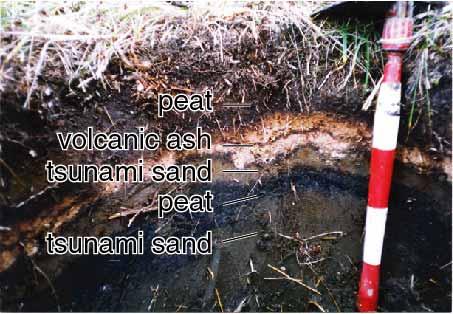
27 Past earthquakes along Sumatran trench Seih et al. (2004, AGU fall meeting) No giant earthquakes have struck the outer-arc islands of western Sumatra since the sequence of 1797, 1833 and Mw 9.0 slip 10 m uplift 2m Paleoseismic studies of coral microatolls reveal that failure of the subduction interface occurs in clusters of such earthquakes about every 230 years. Thus, the next such sequence may well be no more than a few decades away.


28 Cascadia subduction zone Comparison with 2004 eq B. Atwater (USGS)
")


29 1700 Cascadia earthquake (Mw~9) January 26, 1700 Satake et al., 2003 J. Geophys. Res. Japanese documents Cascadia fault Comparison of tsunami heights
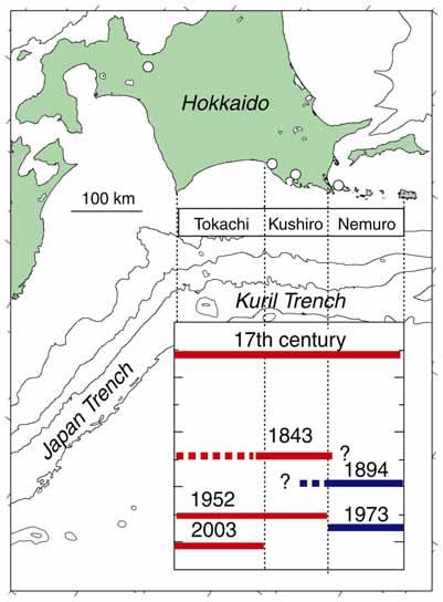
30 Earthquake recurrence along Kuril Trench
31 Earthquake recurrence Earthquake occurrence Periodical Time between eqs. Random in time Poisson Process
32 Earthquake recurrence Earthquake occurrence Periodical Probability in next 30 yrs Random in time Poisson Process Time since last earthquake
33 Earthquake probability along Kuril trench 30 year probability as of March 2003 Mw % 03/09/26 M 8.0 M 8.1 ~60% M % 1843 M M 8.2 Mw % 04/11/29 M Mt Mw M Mw 8.2 Smaller eq. M % 1918 Mt Mw 8.5 Smaller eq. Mw 7.7 >90% HQ Earthq Res Prom, March 2003
34 Outline 1. The largest earthquake in the last 40 years 2. Tsunami generation and propagation 3. Past and future earthquakes 4. Tsunami warning and hazard reduction systems
 The tsunami arrived Hawaii 15 hrs; 60 casualties Japan 23 hrs;")

35 1960 Chilean earthquake Largest eq. in 20 th century (Mw 9.5) The tsunami arrived Hawaii 15 hrs; 60 casualties Japan 23 hrs; 150 casualties Int l Tsunami Warning System Very few knowledge - No plate tectonics - No global seismic network - Ms= 8.5 Onagawa, Japan


36 Tsunami Warning System Global seismic network Sea level network DART buoys GLOSS Global Sea Level Observing System NOAA
37 Tsunami Information Bulletins from PTWC December 26, GMT Earthquake 1:14 GMT ( 1 st bulletin 15 min after the eq.) LOCATION - OFF W COAST OF NORTHERN SUMATERA MAGNITUDE : 08 GMT 2 nd bulletin 69 min after the eq.) LOCATION - OFF W COAST OF NORTHERN SUMATERA MAGNITUDE EVALUATION REVISED MAGNITUDE THERE IS THE POSSIBILITY OF A TSUNAMI NEAR THE EPICENTER.


38 Dissemination of Warning to Residents satellite Local Government s Local Meteorological Observatory Dedicated phone line Police, Fire office TV Residents JMA Japanese Government Radio etc

39 Tsunami evacuation maps Phonebooks in Hawaii

 Papua Geological New Guinea, Survey")
40 Effect of education Recent Examples: 1993 Japan with tsunami knowledge and experience 15% of residents die 1998 Papua New Guinea w/o tsunami knowledge 75% of residents die 1999 Vanuatu, Pentecost Island Video on PNG tsunami educates local village only 10 die (1000s homeless) Papua Geological New Guinea, Survey 1998 of Japan


41 Tsunami Warning and Hazard Reduction Tsunami Warning System Seismic Obs Sea Level Obs Hazard Mitigation Education and Awareness Tsunami Warning Message e.g., JMA, PTWC Coastal Communities Residents Evacuation
42 Conclusions 1. The 2004 Sumatra-Andaman earthquake was the largest event in the last 40 years and caused >200,000 tsunami casualties. 2. The tsunami was recorded by tide gauges, satellite altimetry and field surveys, and the data are used in real time to study the tsunami source. 3. Past tsunamis can be studied by historic and geologic data. Data from such paleoseismological studies can be used for probabilistic estimates of future earthquakes and tsunamis. 4. To prevent future disaster, tsunami warning systems, hazard assessment and preparation, and education are all necessary.
GNH7/GG09/GEOL4002 EARTHQUAKE SEISMOLOGY AND EARTHQUAKE HAZARD
 Tectonics Lecture 10 Global Seismotectonics Rigid plate translation A Map of the World s Fracture Zones Magnetic anomalies and fracture zones form the basic building blocks for the construction of isochron
Preparation for Future Earthquake and Tsunami Hazards: Lessons Learned from the 2004 Sumatra-Andaman Earthquake and the Asian Tsunami
 First International Conference of Aceh and Indian Ocean Studies Organized by Asia Research Institute, National University of Singapore & Rehabilitation and Construction Executing Agency for Aceh and Nias
Forecasting Future Earthquakes from Tsunami Deposits and Simulation
 Forecasting Future Earthquakes from Tsunami Deposits and Simulation Kenji Satake Earthquake Research Institute The University of Tokyo satake@eri.u-tokyo.ac.jp Contents 1. Earthquake Recurrence and Forecast
Earthquakes and Tsunamis
 Earthquakes and Tsunamis Kenji Satake Earthquake Research Institute University of Tokyo 1 Part I 2011 Tohoku earthquake and tsunami 2 Fukushima Dai ichi NPP accident Earthquake ground motion Reactors automatically
News Release December 30, 2004 The Science behind the Aceh Earthquake
 News Release December 30, 2004 The Science behind the Aceh Earthquake PASADENA, Calif. - Kerry Sieh, the Robert P. Sharp Professor of Geology at the California Institute of Technology and a member of Caltech's
Indian Ocean Tsunami Warning System: Example from the 12 th September 2007 Tsunami
 Indian Ocean Tsunami Warning System: Example from the 12 th September 2007 Tsunami Charitha Pattiaratchi 1 Professor of Coastal Oceanography, The University of Western Australia Email: chari.pattiaratchi@uwa.edu.au
1.3 Short Review: Preliminary results and observations of the December 2004 Great Sumatra Earthquake Kenji Hirata
 1.3 Short Review: Preliminary results and observations of the December 2004 Great Sumatra Earthquake Kenji Hirata We give a brief review about observations and preliminary results regarding the 2004 great
Seismic Activity and Crustal Deformation after the 2011 Off the Pacific Coast of Tohoku Earthquake
 J-RAPID Symposium March 6-7, 2013 Seismic Activity and Crustal Deformation after the 2011 Off the Pacific Coast of Tohoku Earthquake Y. Honkura Tokyo Institute of Technology Japan Science and Technology
Establishment and Operation of a Regional Tsunami Warning Centre
 Establishment and Operation of a Regional Tsunami Warning Centre Dr. Charles McCreery, Director NOAA Richard H. Hagemeyer Pacific Tsunami Warning Center Ewa Beach, Hawaii USA Why A Regional Tsunami Warning
Lessons Learned from Past Tsunamis Warning and Emergency Response
 UNESCO IOC CTIC US NOAA ITIC Regional Training Workshop on Strengthening Tsunami Warning and Emergency Response Standard Operating Procedures and the Development of the ICG/CARIBE-EWS PTWC New Enhanced
Earthquake Hazards. Tsunami
 Earthquake Hazards Tsunami Review: What is an earthquake? Earthquake is the vibration (shaking) and/or displacement of the ground produced by the sudden release of energy. The point inside the Earth where
STUDY ON TSUNAMIGENIC EARTHQUAKE CRITERIA FOR THE INDONESIAN TSUNAMI EARLY WARNING SYSTEM
 STUDY ON TSUNAMIGENIC EARTHQUAKE CRITERIA FOR THE INDONESIAN TSUNAMI EARLY WARNING SYSTEM Nanang T. Puspito 1 1 Geophysics Research Group, Faculty of Mining and Petroleum Engineering, Institute of Technology
Earthquake Hazards. Tsunami
 Earthquake Hazards Tsunami Review: What is an earthquake? Earthquake is the vibration (shaking) and/or displacement of the ground produced by the sudden release of energy. The point inside the Earth where
JMA Tsunami Warning Services. Takeshi KOIZUMI Senior Coordinator for International Earthquake and Tsunami Information Japan Meteorological Agency
 JMA Tsunami Warning Services Takeshi KOIZUMI Senior Coordinator for International Earthquake and Tsunami Information Japan Meteorological Agency Tectonic Setting of Japan (Headquarters for Earthquake Research
Earthquake Hazards. Tsunami
 Earthquake Hazards Tsunami Measuring Earthquakes Two measurements that describe the power or strength of an earthquake are: Intensity a measure of the degree of earthquake shaking at a given locale based
Earthquakes Physical Geology 2017 Part 1: Exploring Earthquake distributions. Home butto California Earthquakes: 1) 2) 3) above
 2) 3) above") Earthquakes Physical Geology 2017 Adapted from a lab by Jennifer Wenner This lab is designed to give you experience exploring seismicity associated with different plate boundaries. You will examine seismograms
Earthquakes Physical Geology 2017 Adapted from a lab by Jennifer Wenner This lab is designed to give you experience exploring seismicity associated with different plate boundaries. You will examine seismograms
A GLOBAL SURGE OF GREAT EARTHQUAKES FROM AND IMPLICATIONS FOR CASCADIA. Thorne Lay, University of California Santa Cruz
 A GLOBAL SURGE OF GREAT EARTHQUAKES FROM 2004-2014 AND IMPLICATIONS FOR CASCADIA Thorne Lay, University of California Santa Cruz Last 10 yrs - 18 great earthquakes: rate 1.8/yr; rate over preceding century
(energy loss is greater with longer wavelengths)
") GEOL 0820 Ramsey Natural Disasters Spring, 2018 LECTURE #9: Tsunami Monitoring & Mitigation Date: 8 February 2018 I. Characteristics (con t): shoaling: o process of wave height increase and breaking as
GEOL 0820 Ramsey Natural Disasters Spring, 2018 LECTURE #9: Tsunami Monitoring & Mitigation Date: 8 February 2018 I. Characteristics (con t): shoaling: o process of wave height increase and breaking as
Introduction to Environmental Geology, 5e Case History: Indonesian Tsunami Indonesian Tsunami (2) Introduction Historic Tsunamis
 Introduction Historic Tsunamis") 1 2 3 4 5 6 7 8 9 Introduction to Environmental Geology, 5e Chapter 7 Tsunami Case History: Indonesian Tsunami December 26, 2004, within a few hours, close to 250,000 people were killed With no warning
1 2 3 4 5 6 7 8 9 Introduction to Environmental Geology, 5e Chapter 7 Tsunami Case History: Indonesian Tsunami December 26, 2004, within a few hours, close to 250,000 people were killed With no warning
General-Circulation- Model System for Global Tsunami Warning
 A Coupled Teleseismic Ocean-General General-Circulation- Model System for Global Tsunami Warning Y. Tony Song Jet Propulsion Laboratory, California Institute of Technology Contents:. Tsunami formation
TSUNAMI CHARACTERISTICS OF OUTER-RISE EARTHQUAKES ALONG THE PACIFIC COAST OF NICARAGUA - A CASE STUDY FOR THE 2016 NICARAGUA EVENT-
 TSUNAMI CHARACTERISTICS OF OUTER-RISE EARTHQUAKES ALONG THE PACIFIC COAST OF NICARAGUA - A CASE STUDY FOR THE 2016 NICARAGUA EVENT- Amilcar Cabrera Supervisor: Yuichiro TANIOKA MEE16718 ABSTRACT Nicaragua
NUMERICAL SIMULATIONS FOR TSUNAMI FORECASTING AT PADANG CITY USING OFFSHORE TSUNAMI SENSORS
 NUMERICAL SIMULATIONS FOR TSUNAMI FORECASTING AT PADANG CITY USING OFFSHORE TSUNAMI SENSORS Setyoajie Prayoedhie Supervisor: Yushiro FUJII MEE10518 Bunichiro SHIBAZAKI ABSTRACT We conducted numerical simulations
JMA Tsunami Warning Services. Tomoaki OZAKI Senior Coordinator for Tsunami Forecast Modeling Japan Meteorological Agency
 JMA Tsunami Warning Services Tomoaki OZAKI Senior Coordinator for Tsunami Forecast Modeling Japan Meteorological Agency Organization Chart of the Government of Japan Cabinet Office Diet Ministry of Internal
The Mega-Earthquakes of Chile: Seismology and the Sounds of the Earth
 The Mega-Earthquakes of Chile: Seismology and the Sounds of the Earth Michael Wysession Department of Earth and Planetary Sciences Washington University, St. Louis, MO Puerto Montt, Chile, November 6,
Introduction to Environmental Geology, 5e
 Lecture Presentation prepared by X. Mara Chen, Salisbury University Introduction to Environmental Geology, 5e Edward A. Keller Chapter 7 Tsunami Case History: Indonesian Tsunami December 26, 2004, within
Magnitude 7.5 NEW BRITAIN REGION, PAPUA NEW GUINEA
 A magnitude 7.5 earthquake struck off the eastern coast of Papua New Guinea on Tuesday, approximately 130 km (81 mi) southsouthwest of Kokopo at a depth of 42 km (26.1 mi). There are reports of some structural
Three Dimensional Simulations of Tsunami Generation and Propagation
 Chapter 1 Earth Science Three Dimensional Simulations of Tsunami Generation and Propagation Project Representative Takashi Furumura Authors Tatsuhiko Saito Takashi Furumura Earthquake Research Institute,
We have previously looked at artificial seismograms such as this one here.
 We have previously looked at artificial seismograms such as this one here. S P A realistic Seismic Record Each vertical line = 1 minute Each horizontal line = 15 minutes Seismic station PMM is in Parkfield,
Disclaimer. This report was compiled by an ADRC visiting researcher (VR) from ADRC member countries.
 from ADRC member countries.") Disclaimer This report was compiled by an ADRC visiting researcher (VR) from ADRC member countries. The views expressed in the report do not necessarily reflect the views of the ADRC. The boundaries and
Disclaimer This report was compiled by an ADRC visiting researcher (VR) from ADRC member countries. The views expressed in the report do not necessarily reflect the views of the ADRC. The boundaries and
Effect of the Emperor seamounts on trans-oceanic propagation of the 2006 Kuril Island earthquake tsunami
 GEOPHYSICAL RESEARCH LETTERS, VOL. 35, L02611, doi:10.1029/2007gl032129, 2008 Effect of the Emperor seamounts on trans-oceanic propagation of the 2006 Kuril Island earthquake tsunami S. Koshimura, 1 Y.
Tsunami Simulation of 2009 Dusky Sound Earthquake in New Zealand
 Tsunami Simulation of 2009 Dusky Sound Earthquake in New Zealand Polina Berezina 1 Institute of Geology, Taras Shevchenko National University of Kyiv, Kyiv, Ukraine Supervisor: Prof. Kenji Satake Earthquake
Tsunami waveform inversion of the 2007 Bengkulu, southern Sumatra, earthquake
 LETTER Earth Planets Space, 60, 993 998, 2008 Tsunami waveform inversion of the 2007 Bengkulu, southern Sumatra, earthquake Yushiro Fujii 1 and Kenji Satake 2 1 International Institute of Seismology and
Source of the July 2006 West Java tsunami estimated from tide gauge records
 GEOPHYSICAL RESEARCH LETTERS, VOL. 33, L24317, doi:10.1029/2006gl028049, 2006 Source of the July 2006 West Java tsunami estimated from tide gauge records Yushiro Fujii 1 and Kenji Satake 2 Received 13
DATA BASE DEVELOPMENT OF ETA (ESTIMATED TIME OF ARRIVAL) FOR TSUNAMI DISASTER MITIGATION AT SOUTHWESTERN CITIES OF ACEH, INDONESIA
 FOR TSUNAMI DISASTER MITIGATION AT SOUTHWESTERN CITIES OF ACEH, INDONESIA") 6 th South China Sea Tsunami Workshop Nanyang Technology University, Singapore, 6-8 November 2013 DATA BASE DEVELOPMENT OF ETA (ESTIMATED TIME OF ARRIVAL) FOR TSUNAMI DISASTER MITIGATION AT SOUTHWESTERN
6 th South China Sea Tsunami Workshop Nanyang Technology University, Singapore, 6-8 November 2013 DATA BASE DEVELOPMENT OF ETA (ESTIMATED TIME OF ARRIVAL) FOR TSUNAMI DISASTER MITIGATION AT SOUTHWESTERN
This document is downloaded from DR-NTU, Nanyang Technological University Library, Singapore.
 This document is downloaded from DR-NTU, Nanyang Technological University Library, Singapore. Title Aceh Andaman earthquake : what happened and what's next? Author(s) Sieh, Kerry Citation Sieh, K. (2005).
Tsunami Physics and Preparedness. March 6, 2005 ICTP Public Information Office 1
 Tsunami Physics and Preparedness March 6, 2005 ICTP Public Information Office 1 What we do Provide world-class research facilities for scientists from developing world Foster advanced scientific research,
FOCAL MECHANISMS OF SUBDUCTION ZONE EARTHQUAKES ALONG THE JAVA TRENCH: PRELIMINARY STUDY FOR THE PSHA FOR YOGYAKARTA REGION, INDONESIA
 FOCAL MECHANISMS OF SUBDUCTION ZONE EARTHQUAKES ALONG THE JAVA TRENCH: PRELIMINARY STUDY FOR THE PSHA FOR YOGYAKARTA REGION, INDONESIA Myo Thant 1, Hiroshi Kawase 2, Subagyo Pramumijoyo 3, Heru Hendrayana
The ITSU System in the Pacific Region and Future Upgrades
 The ITSU System in the Pacific Region and Future Upgrades Eddie Bernard Director, Pacific Marine Environmental Laboratory (PMEL) NOAA/USA Pacific Tsunami Warning Center OPERATIONAL ACTIVITIES SEISMIC DATA
Tsunami waveform analyses of the 2006 underthrust and 2007 outer-rise Kurile earthquakes
 Author(s) 2008. This work is licensed under a Creative Commons License. Advances in Geosciences Tsunami waveform analyses of the 2006 underthrust and 2007 outer-rise Kurile earthquakes Y. Tanioka 1, Y.
DEVASTATING DAMAGE DUE TO THE 2004 INDIAN OCEAN TSUNAMI AND ITS LESSONS
 DEVASTATING DAMAGE DUE TO THE 2004 INDIAN OCEAN TSUNAMI AND ITS LESSONS Fumihiko Imamura 1 1 Professor, Tsunami Engineering, Disaster Control Research Center, Tohoku University, Japan Email: imamura@tsunami2.civil.tohoku.ac.jp
Name: Date: Bell: The Sumatra Earthquake and Tsunami December 26, 2004
 Name: Date: Bell: The Sumatra Earthquake and Tsunami December 26, 2004 Introduction: The incredible damage and tragic loss of life resulting from the 9.0 magnitude earthquake and ensuing tsunami was shocking
Tsunami Response and the Enhance PTWC Alerts
 Tsunami Response and the Enhance PTWC Alerts Ken Gledhill GeoNet Project Director Chair, Intergovernmental Coordination Group, Pacific Tsunami Warning and Mitigation System (PTWS) Overview 1. Procedures
NUMERICAL SIMULATION OF TSUNAMI PROPAGATION AND INUNDATION ALONG THE RAKHINE COAST AREAS IN MYANMAR
 NUMERICAL SIMULATION OF TSUNAMI PROPAGATION AND INUNDATION ALONG THE RAKHINE COAST AREAS IN MYANMAR Su Hninn Htwe Supervisor: Bunichiro SHIBAZAKI MEE12619 Yushiro FUJII ABSTRACT This study aimed to assess
Sendai Earthquake NE Japan March 11, Some explanatory slides Bob Stern, Dave Scholl, others updated March
 Sendai Earthquake NE Japan March 11, 2011 Some explanatory slides Bob Stern, Dave Scholl, others updated March 14 2011 Earth has 11 large plates and many more smaller ones. Plates are 100-200 km thick
Inversion of tsunami data. A. Sladen CNRS, Géoazur 1/35
 Inversion of tsunami data A. Sladen CNRS, Géoazur 1/35 DEFINITION Tsunami waves are gravity wave with a long period need a BIG source! 2/35 DEFINITION Krakatoa, 1883 Summer 2015, E.T. pers. comm. Lituya
Tsunami waves swept away houses and cars in northern Japan and pushed ships aground.
 Japan was struck by a magnitude 8.9 earthquake off its northeastern coast Friday. This is one of the largest earthquakes that Japan has ever experienced. In downtown Tokyo, large buildings shook violently
Scaling relations of seismic moment, rupture area, average slip, and asperity size for M~9 subduction-zone earthquakes
 GEOPHYSICAL RESEARCH LETTERS, VOL. 4, 7 74, doi:1.12/grl.976, 213 Scaling relations of seismic moment, rupture area, average slip, and asperity size for M~9 subduction-zone earthquakes Satoko Murotani,
Banda Aceh December 26th Earthquake monitored by GPS
 Banda Aceh December 26th Earthquake monitored by GPS C. Vigny (1), W.J.F. Simons (2), S. Abu (3), Chalermchon Satirapod (4), M. Hashizume (5), Sarayut Yousamran (6), C. Subarya (7), K. Omar (8), H.Z. Abidin
Magnitude 7.5 NEW BRITAIN REGION, PAPUA NEW GUINEA
 A magnitude 7.5 earthquake struck off the eastern coast of Papua New Guinea on Sunday, approximately 54 km (33 miles) southeast of Kokopo. Residents reported strong ground shaking for about five minutes.
Numerical Simulation of the December 26,2004: Indian Ocean Tsunami
 Numerical Simulation of the December 26,2004: Indian Ocean Tsunami J. Asavanant, 1 M. Ioualalen, 2 N. Kaewbanjak, 1 S.T. Grilli, 3 P. Watts, 4 J.T. Kirby, 5 and F. Shi 5 1 Advanced Virtual and Intelligent
Coseismic slip model
 Figure 3 - Preliminary highly smoothed model of coseismic slip for the 11 March UCL Institute for Risk & Disaster Reduction Magnitude 9.0 (JMA scale) earthquake Occurred at 02:46:23 pm local time near
What scientists know and do not know about the big one at Cascadia
 What scientists know and do not know about the big one at Cascadia Kelin Wang Pacific Geoscience Centre, Geological Survey of Canada Natural Resources Canada The Cascadia Subduction Zone M 7.3, 1946 Rupture
EARTHQUAKE SOURCE PARAMETERS FOR SUBDUCTION ZONE EVENTS CAUSING TSUNAMIS IN AND AROUND THE PHILIPPINES
 EARTHQUAKE SOURCE PARAMETERS FOR SUBDUCTION ZONE EVENTS CAUSING TSUNAMIS IN AND AROUND THE PHILIPPINES Joan Cruz SALCEDO Supervisor: Tatsuhiko HARA MEE09186 ABSTRACT We have made a set of earthquake source
The Challenge of Earthquake Disaster in Indonesia. Hery Harjono Indonesian Institute of Sciences
 The Challenge of Earthquake Disaster in Indonesia Hery Harjono Indonesian Institute of Sciences * Presented at the J-Rapid Symposium, Sendai, Japan, March 6-7, 2013 INTRODUCTION The 2004 Giant Sumatran-Andaman
Magnitude 7.7 QUEEN CHARLOTTE ISLANDS REGION
 A major 7.7 magnitude earthquake struck at 8:04 PM local time in western British Columbia, Canada. The epicenter is located on Moresby Island, the southern large island in the Queen Charlotte Islands region.
Earthquake Source. Kazuki Koketsu. Special Session: Great East Japan (Tohoku) Earthquake. Earthquake Research Institute, University of Tokyo
 Earthquake. Earthquake Research Institute, University of Tokyo") 2012/9/24 17:20-17:35 WCEE SS24.4 Special Session: Great East Japan (Tohoku) Earthquake Earthquake Source Kazuki Koketsu Earthquake Research Institute, University of Tokyo 1 Names and features of the earthquake
2012/9/24 17:20-17:35 WCEE SS24.4 Special Session: Great East Japan (Tohoku) Earthquake Earthquake Source Kazuki Koketsu Earthquake Research Institute, University of Tokyo 1 Names and features of the earthquake
Advisors: Arcadii Grinshpan, Mathematics and Statistics Rocco Malservisi, School of Geosciences. Problem Suggested By: Rocco Malservisi
 Undergraduate Journal of Mathematical Modeling: One + Two Volume 8 2018 Spring 2018 Issue 2 Article 6 Tsunami Waves Samantha Pennino University of South Florida Advisors: Arcadii Grinshpan, Mathematics
Title. Author(s)Heki, Kosuke. CitationScience, 332(6036): Issue Date Doc URL. Type. File Information. A Tale of Two Earthquakes
Heki, Kosuke. CitationScience, 332(6036): Issue Date Doc URL. Type. File Information. A Tale of Two Earthquakes") Title A Tale of Two Earthquakes Author(s)Heki, Kosuke CitationScience, 332(6036): 1390-1391 Issue Date 2011-06-17 Doc URL http://hdl.handle.net/2115/48524 Type article (author version) File Information
Title A Tale of Two Earthquakes Author(s)Heki, Kosuke CitationScience, 332(6036): 1390-1391 Issue Date 2011-06-17 Doc URL http://hdl.handle.net/2115/48524 Type article (author version) File Information
SOP of PTWC as a Regional Tsunami Service Provider
 UNESCO IOC CTIC US NOAA ITIC Regional Training Workshop on Strengthening Tsunami Warning and Emergency Response Standard Operating Procedures and the Development of the ICG/CARIBE-EWS PTWC New Enhanced
TWC Operations Challenges and Limitations
 UNESCO IOC CTIC US NOAA ITIC Regional Training Workshop on Strengthening Tsunami Warning and Emergency Response Standard Operating Procedures and the Development of the ICG/CARIBE-EWS PTWC New Enhanced
"The Natural Disasters, like The Sumatra Tsunami had taught us before -BUT" U Than Myint President Myanmar Engineering Society
 "The Natural Disasters, like The Sumatra Tsunami had taught us before -BUT" U Than Myint President Myanmar Engineering Society Present Day Regional Tectonic Setting of South East Asia Tsunami-generated
LOCAL TSUNAMIS: CHALLENGES FOR PREPAREDNESS AND EARLY WARNING
 LOCAL TSUNAMIS: CHALLENGES FOR PREPAREDNESS AND EARLY WARNING HARALD SPAHN 1 1 German Technical Cooperation International Services, Jakarta, Indonesia ABSTRACT: Due to the threat of local tsunamis warning
Earthquakes 11/14/2014. Earthquakes Occur at All Boundaries. Earthquakes. Key Aspects of an Earthquake. Epicenter. Focus
 Earthquakes Earthquakes Caused by friction and movement between Earth s tectonic plates A release of force Often caused by a catch between two plates As plates slide by, they stick to each other When the
Report on Banda Aceh mega-thrust earthquake, December 26, 2004
 Report on Banda Aceh mega-thrust earthquake, December 26, 2004 Prepared January 7 th 2005 by C. Vigny, on behalf of the SEAMERGES (*) participants On the morning of December 26 th, 2004 in SE Asia, 30
DETERMINATION OF SLIP DISTRIBUTION OF THE 28 MARCH 2005 NIAS EARTHQUAKE USING JOINT INVERSION OF TSUNAMI WAVEFORM AND GPS DATA
 Synopses of Master Papers Bulletin of IISEE, 47, 115-10, 013 DETERMINATION OF SLIP DISTRIBUTION OF THE 8 MARCH 005 NIAS EARTHQUAKE USING JOINT INVERSION OF TSUNAMI WAVEFORM AND GPS DATA Tatok Yatimantoro
Current tsunami research activities in the Philippines
 DOST PHIVOLCS Current tsunami research activities in the Philippines Graciano P. Yumul, Jr. 1,2, Carla B. Dimalanta 1 and Bart Bautista 3 1 National Institute of Geological Sciences, University of the
Magnitude 7.0 PAPUA, INDONESIA
 A 7.0 magnitude earthquake struck eastern Indonesia's mountainous West Papua province on Saturday but there were no immediate reports of casualties or damage. The region is sparsely populated. According
Seismic Activity near the Sunda and Andaman Trenches in the Sumatra Subduction Zone
 IJMS 2017 vol. 4 (2): 49-54 International Journal of Multidisciplinary Studies (IJMS) Volume 4, Issue 2, 2017 DOI: http://doi.org/10.4038/ijms.v4i2.22 Seismic Activity near the Sunda and Andaman Trenches
Real Time Monitoring System for Megathrust Earthquakes and Tsunamis - Cabled Network System and Buoy System in Japan -
 Real Time Monitoring System for Megathrust Earthquakes and Tsunamis - Cabled Network System and Buoy System in Japan - 1 Subduction zones around the world Haiti Italy Turkey Tohoku Sichuan Taiwan Sumatra
Magnitude 7.9 SE of KODIAK, ALASKA
 A magnitude 7.9 earthquake occurred at 12:31 am local time 181 miles southeast of Kodiak at a depth of 25 km (15.5 miles). There are no immediate reports of damage or fatalities. Light shaking from this
Report on Banda Aceh mega-thrust earthquake, December 26, 2004
 Report on Banda Aceh mega-thrust earthquake, December 26, 2004 Prepared January 7 th 2005 by C. Vigny, on behalf of the SEAMERGES (*) participants On the morning of December 26 th in SE Asia, 30 km below
Characteristics of seismic activity before Chile M W 8.8 earthquake in 2010
 Earthq Sci (2010)23: 333 341 333 Doi: 10.1007/s11589-010-0730-x Characteristics of seismic activity before Chile M W 8.8 earthquake in 2010 Yan Xue 1,2, Jie Liu 2 and Gang Li 2 1 Institute of Geophysics,
The 2004 Indian Ocean tsunami: Tsunami source model from satellite altimetry
 Earth Planets Space,, 9, The Indian Ocean tsunami: Tsunami source model from satellite altimetry Kenji Hirata, Kenji Satake, Yuichiro Tanioka 3, Tsurane Kuragano, Yohei Hasegawa, Yutaka Hayashi, and Nobuo
Seismic Characteristics and Energy Release of Aftershock Sequences of Two Giant Sumatran Earthquakes of 2004 and 2005
 P-168 Seismic Characteristics and Energy Release of Aftershock Sequences of Two Giant Sumatran Earthquakes of 004 and 005 R. K. Jaiswal*, Harish Naswa and Anoop Singh Oil and Natural Gas Corporation, Vadodara
Probabilistic Tsunami Hazard Assessment addressing the uncertainty of tsunami source
 Probabilistic Tsunami Hazard Assessment addressing the uncertainty of tsunami source Pacific Rim Forum 2017 January 23, 2017 Yuta Abe, ITOCHU Techno-Solutions Corporation, Japan Copyright (c)2017 ITOCHU
SMR/ May Simulation Analyses of Tsunami caused by Chilean and Nihon-Kai Chubu Earthquakes at Nuclear Power Plant Sites in Japan
 SMR/1839-2 Workshop on the Physics of Tsunami, Hazard Assessment Methods and Disaster Risk Management (Theories and Practices for Implementing Proactive Countermeasures) 14-18 May 2007 Simulation Analyses
Inquiry: Sumatran earthquakes with GPS Earth Science Education
 Inquiry: Sumatran earthquakes with GPS Earth Science Education www.earthobservatory.sg Preparation: Before doing this investigation, complete two introductory investigations using GPS data from UNAVCO
Earthquakes. Earthquake Magnitudes 10/1/2013. Environmental Geology Chapter 8 Earthquakes and Related Phenomena
 Environmental Geology Chapter 8 Earthquakes and Related Phenomena Fall 2013 Northridge 1994 Kobe 1995 Mexico City 1985 China 2008 Earthquakes Earthquake Magnitudes Earthquake Magnitudes Richter Magnitude
NUMERICAL SIMULATION AS GUIDANCE IN MAKING TSUNAMI HAZARD MAP FOR LABUAN ISLAND
 NUMERICAL SIMULATION AS GUIDANCE IN MAKING TSUNAMI HAZARD MAP FOR LABUAN ISLAND MOHD RIDZUAN bin Adam Supervisor: Fumihiko IMAMURA MEE09199 ABSTRACT At the northeast end of the South China Sea, tsunamis
Chapter 6. Strong Motions
 Chapter 6 Strong Motions In spite of the scale of this earthquake, there is unfortunately no strong motion record nearby the causative fault. The nearest seismograph is approximately 80km from the epicenter
Three Fs of earthquakes: forces, faults, and friction. Slow accumulation and rapid release of elastic energy.
 Earthquake Machine Stick-slip: Elastic Rebound Theory Jerky motions on faults produce EQs Three Fs of earthquakes: forces, faults, and friction. Slow accumulation and rapid release of elastic energy. Three
Tsunami Risk Mitigation Strategy for Thailand. Kjell Karlsrud Norwegian Geotechnical Institute (NGI)
") Tsunami Risk Mitigation Strategy for Thailand Kjell Karlsrud Norwegian Geotechnical Institute (NGI) The project was undertaken by NGI in cooperation with: NORSAR, UiB, UiO, NIBR, B.Heyerdahl, NTNU, Sintef
Tsunami Risk Mitigation Strategy for Thailand Kjell Karlsrud Norwegian Geotechnical Institute (NGI) The project was undertaken by NGI in cooperation with: NORSAR, UiB, UiO, NIBR, B.Heyerdahl, NTNU, Sintef
Source modeling of hypothetical Tokai-Tonankai-Nankai, Japan, earthquake and strong ground motion simulation using the empirical Green s functions
 Source modeling of hypothetical Tokai-Tonankai-Nankai, Japan, earthquake and strong ground motion simulation using the empirical Green s functions Y. Ishii & K. Dan Ohsaki Research Institute, Inc., Tokyo
Tsunami and earthquake in Chile Part 2
 EUROPEAN COMMISSION DIRECTORATE GENERAL JRC JOINT RESEARCH CENTRE Institute for the Protection and Security of the Citizen Global Security and Crisis Management Unit CriTech Sunday, 28 February 2010 Executive
Earthquakes, volcanic eruptions, tsunamis (why do we live here?) Tectonic plates. Tectonic plates: Juan de Fuca. Volcanism the past 37 million years
 Tectonic plates. Tectonic plates: Juan de Fuca. Volcanism the past 37 million years") Earthquakes, volcanic eruptions, tsunamis (why do we live here?) Tectonic plates Tectonic plates: Juan de Fuca Volcanism the past 37 million years Tectonic plates: Juan de Fuca Volcanism the past 37 million
Earthquakes, volcanic eruptions, tsunamis (why do we live here?) Tectonic plates Tectonic plates: Juan de Fuca Volcanism the past 37 million years Tectonic plates: Juan de Fuca Volcanism the past 37 million
REAL-TIME TSUNAMI INUNDATION FORECAST STUDY IN CHIMBOTE CITY, PERU
 REAL-TIME TSUNAMI INUNDATION FORECAST STUDY IN CHIMBOTE CITY, PERU Nabilt Moggiano Supervisor: Kenji SATAKE MEE16720 ABSTRACT For rapid forecast of tsunami inundation during a tsunamigenic event, we constructed
SSA Annual Meeting Tip Sheet on Special Session: New observations, data on Japan and New Zealand earthquakes
 For Immediate Release Media contact: Nan Broadbent E-mail: press@seismosoc.org; phone: 408-431-9885 SSA Annual Meeting Tip Sheet on Special Session: New observations, data on Japan and New Zealand earthquakes
Real time Monitoring System for Earthquakes and Tsunamis (DONET)
") Real time Monitoring System for Earthquakes and Tsunamis (DONET) NankaiTrough Yoshiyuki Kaneda Japan Agency for Marine-Earth Science and Technology (JAMSTEC) POGO@Seoul Presentation 1 Earthquakes in the
Real time Monitoring System for Earthquakes and Tsunamis (DONET) NankaiTrough Yoshiyuki Kaneda Japan Agency for Marine-Earth Science and Technology (JAMSTEC) POGO@Seoul Presentation 1 Earthquakes in the
Magnitude 8.3 SEA OF OKHOTSK
 A powerful earthquake in Russia's Far East was felt as far away as Moscow, about 7,000 kilometers (4,400 miles) west of the epicenter, but no casualties or damage were reported. The epicenter was in the
Tsunamis and ocean waves
 Department of Mathematics & Statistics AAAS Annual Meeting St. Louis Missouri February 19, 2006 Introduction Tsunami waves are generated relatively often, from various sources Serious tsunamis (serious
Overview of Consequences of the Tsunami in Thailand and Roles and Activities of the Department of Mineral Resources after the 26 December 2004 Tsunami
 Overview of Consequences of the Tsunami in Thailand and Roles and Activities of the after the 26 December 2004 Tsunami By Mr.Worawoot Tantiwanit, Thailand 1 Earthquake in NW of North Sumatra Island 580
AN ABNORMAL TSUNAMI GENERATED BY OCTOBER 25 th, 2010 MENTAWAI EARTHQUAKE
 AN ABNORMAL TSUNAMI GENERATED BY OCTOBER 25 th, 2010 MENTAWAI EARTHQUAKE Bambang Sunardi 1, Suci Dewi Anugrah 2, Thomas Hardy 1, Drajat Ngadmanto 1 1 Research and Development Center, Indonesia Meteorological
5-31. Cambodia. Vietnam. South China S ea. Malaysia. Kuala L umpur. Singapore. Kalimantan. Sunda S trait. Jakarta. Java 98E. Sumatra. Pini.
 5-31 Ridge Ninetyeast 52mm/yr Wharton For e S umatran Ridge Indian Andaman Sea arc 1861 Burma Ridge 1833 Thailand Sumatran Sliver Subduction Southeast Asian P late Malaysia Fault P Cambodia Kuala L umpur
RELOCATION OF LARGE EARTHQUAKES ALONG THE SUMATRAN FAULT AND THEIR FAULT PLANES
 Synopses of Master Papers Bulletin of IISEE, 47, 25-30, 2013 RELOCATION OF LARGE EARTHQUAKES ALONG THE SUMATRAN FAULT AND THEIR FAULT PLANES Biana Rahayu Wulandari MEE11605 Supervisor: Nobuo HURUKAWA ABSTRACT
History of International Training in Seismology and Earthquake Engineering at IISEE
 History of International Training in Seismology and Earthquake Engineering at IISEE Activities of International Institute of Seismology and Earthquake Engineering (IISEE), BRI - Training for young researchers/engineers
Magnitude 8.2 NORTHWEST OF IQUIQUE, CHILE
 An 8.2-magnitude earthquake struck off the coast of northern Chile, generating a local tsunami. The USGS reported the earthquake was centered 95 km (59 miles) northwest of Iquique at a depth of 20.1km
VALIDATION OF TSUNAMI INUNDATION MODELING FOR THE 2004 SUMATRA-ANDAMAN EARTHQUAKE FOR MAKING HAZARD MAPS IN PENANG AND LANGKAWI, MALAYSIA
 Synopses of Master Papers Bulletin of IISEE, 47, 11-16, 013 VALIDATION OF TSUNAMI INUNDATION MODELING FOR THE 004 SUMATRA-ANDAMAN EARTHQUAKE FOR MAKING HAZARD MAPS IN PENANG AND LANGKAWI, MALAYSIA Noor
Status after Six Years
 German-Indonesian Tsunami Early Warning System () Status after Six Years Joern Lauterjung and the -Team Challenge Indonesia Short Early Warning Time Tsunamis are generated at the trench (orange line) Traveltimes
Mechanism of tsunami generation,propagation and runup -sharing experiences with Japanese
 Mechanism of tsunami generation,propagation and runup -sharing experiences with Japanese Mechanism of tsunami generation Predicting the propagation, runup and inundation of tsunamis Near and far-field
Could satellite altimetry have improved early detection and warning of the 2011 Tohoku tsunami?
 GEOPHYSICAL RESEARCH LETTERS, VOL. 39,, doi:10.1029/2012gl052386, 2012 Could satellite altimetry have improved early detection and warning of the 2011 Tohoku tsunami? B. D. Hamlington, 1,2 R. R. Leben,