How to communicate Cascadia Subduction Zone earthquake hazards
|
|
|
- Myles Ward
- 6 years ago
- Views:
Transcription

1 How to communicate Cascadia Subduction Zone earthquake hazards Tom Brocher Research Geophysicist Earthquake Science Center U.S. Geological Survey Menlo Park, California Seattle Post-Intelligencer
2 Lessons from other earthquakes Provide context discuss the hazard in relation to what people have experienced in the past Be realistic about hazards don t conflate them Be clear about what is known and what is not known make sure everyone appreciates that our knowledge will evolve over time Coordinate our communications with emergency managers, engineers, and public health officials Use simple language and a range of formats


3 To encourage preparedness Provide examples of how preparedness has made a difference in previous earthquakes and tsunamis Talk about what is already been done to prepare Tell people what they can do to prepare Showing images of others preparing will more likely lead the audience to take action Retrofit House Emergency Kit Assoc. Bay Area Govts.
4 Learning Lessons for Resiliency from Similar Earthquakes The 1960, 2010, and 2015 Chile, 1964 Alaska, 2004 Sumatra, and the 2011 Japan M9+ subduction earthquakes all taught valuable lessons on survival strategies, hazard mitigation, and building practices. The US sent teams of geoscientists and engineers to learn these lessons. There is good news: Modern building codes in Japan (2011) and in Chile (2010, 2015) resulted in relatively little building damage to newer buildings Biggest lesson: Almost all of the property damage and fatalities resulted from the tsunamis produced by the earthquakes and submarine landslides


5 Tsunami Hazard Mitigation Tsunami inundation maps, signed evacuation routes, tsunami sirens Training in coastal communities that when one feels the earthquake to evacuate when the shaking stops* Vertical evacuation structures: one is under construction in Westport, Washington Hazard avoidance: Land use planning and zoning
6 Tools are in place to hasten recovery Cascadia subduction zone earthquakes have been included in the USGS National Seismic Hazard Map since 1996 and in the building codes since International Building Code The USGS National Seismic Hazard Maps and building codes are updated about every 6 years to incorporate the latest science into local resilience. In the 2011 Japan and the 2010 and 2015 Chilean subduction earthquakes, similar building codes prevented significant building damage to modern buildings USGS earthquake scenario maps USGS is performing supercomputer simulations of strong ground motions: these show that ground motions in the I-5 corridor will be lower than those on the coast

7 M Nisqually Shakemap M9 We ve experienced similar shaking levels before (albeit not the duration of the shaking) The expected shaking levels along the I-5 urban corridor are comparable to the shaking levels experienced in the M Nisqually earthquake Shaking levels are reduced by fact that the earthquake is primarily offshore and deep

8 M Nisqually Shakemap M8.3 USGS National Seismic Hazard Maps include many possibilities to cover all unknowns and uncertainties, including the possibility of M8 earthquakes anywhere on the Cascadia subduction zone Once again, shaking levels along the I-5 urban corridor are comparable to those of the Nisqually earthquake
9 Tools to mitigate aftershocks Large (magnitude 6 to 7) aftershocks will begin immediately after the earthquake Aftershocks will be widespread: along the megathrust, in the downgoing oceanic crust, and in the crust of the Coast Ranges Aftershocks can cause additional damage, hamper rescue operations, and take a psychological toll on people USGS issues aftershock forecasts After the 1989 Loma Prieta earthquake the USGS issued realtime aftershock alerts to rescuers working in a collapsed freeway
10
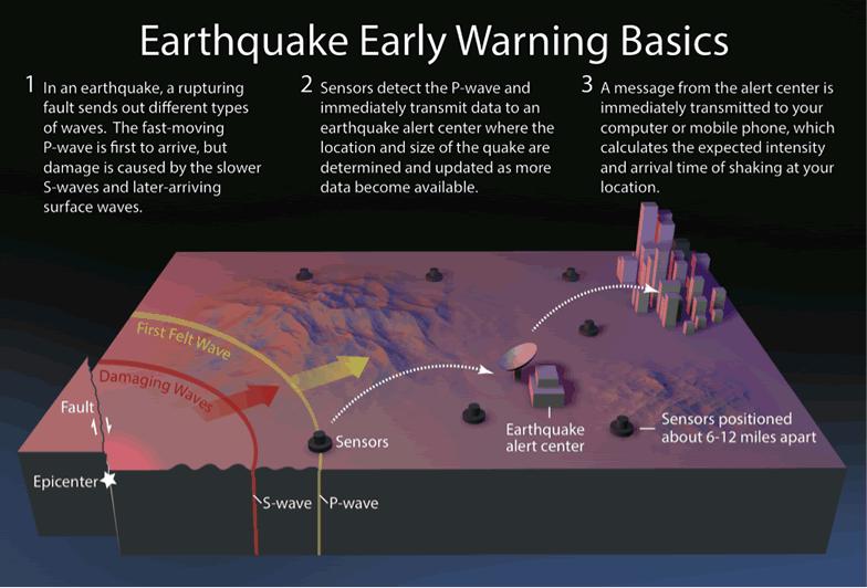
11 Shaking Warning The USGS, University of Washington, UC Berkeley, and Caltech are partnered on a prototype earthquake early warning system called ShakeAlert A similar system in Japan worked during the M Tohoku, Japan earthquake ShakeAlert will provide up to a few minutes of warning for a Cascadia subduction zone earthquake Among many other uses, aftershock alerts can reduce anxiety and inform rescue operations

12 There will be a new coastline along the Pacific Ocean There will be an instant and permanent lowering of the Pacific coast of 3 to 6 feet and daily tides will reach further inland in many low-lying areas. Plan for immediate flooding hazard resulting from this instant sea level rise Plan for longer term coastal erosion
13 Mitigate known vulnerabilities Older pre-code & other vulnerable buildings unreinforced masonry buildings buildings with structurally weak first stories pre-code buildings in soft soils tall buildings in sedimentary basins Tsunami evacuation challenges USGS authored report, 2015


14 Hazard Assessment led to a successful mitigation: Alaska Oil Pipeline in 2002 M7.9 Denali earthquake Before After
15 We have recognized the hazards before the event, now they can be mitigated Geological histories going back thousands of years converge on 500 years as an approximate average amount of time between back-to-back earthquakes along most of the Cascadia subduction zone. This average interval implies a one-in-ten chance of a Cascadia earthquake as large as magnitude 9 within 50 years. For context, the odds of a repeat of a M6.8 Nisqually type earthquake in the Puget Lowland within 50 years are about 8 to 9 times higher.
16 Contact me: Tom Brocher Earthquake Science Center U.S. Geological Survey Menlo Park, California
What is a tsunami? Capital Regional District Tsunami Frequently Asked Questions (FAQ s) Tsunami (soo-nah-mee)
 Tsunami (soo-nah-mee)") Tsunami (soo-nah-mee) Tsunamis (Japanese translation harbour wave ) are waves with a great distance between crests, and are caused by any widespread, sudden movement of large volumes of water. The tsunami
Tsunami (soo-nah-mee) Tsunamis (Japanese translation harbour wave ) are waves with a great distance between crests, and are caused by any widespread, sudden movement of large volumes of water. The tsunami
Three Fs of earthquakes: forces, faults, and friction. Slow accumulation and rapid release of elastic energy.
 Earthquake Machine Stick-slip: Elastic Rebound Theory Jerky motions on faults produce EQs Three Fs of earthquakes: forces, faults, and friction. Slow accumulation and rapid release of elastic energy. Three
Building earthquake early warning for the west coast. Ken Creager Professor of Earth and Space Sciences University of Washington
 Building earthquake early warning for the west coast Ken Creager Professor of Earth and Space Sciences University of Washington How Earthquake Early Warning works: P-waves S-waves 3-fold way of Earthquake
Cascadia megathrust earthquakes: reducing risk through science, engineering, and planning
 Cascadia megathrust earthquakes: reducing risk through science, engineering, and planning NSF Hazards SEES EAR-1331412 Urban Science and Engineering Workshop 21 July 2014 Everything to do with M9 Cascadia
Wainui Beach Management Strategy (WBMS) Summary of Existing Documents. GNS Tsunami Reports
 Summary of Existing Documents. GNS Tsunami Reports") Wainui Beach Management Strategy (WBMS) Summary of Existing Documents GNS Tsunami Reports a) Review of Tsunami Hazard and Risk in New Zealand ( National Risk Report ) b) Review of New Zealand s Preparedness
Wainui Beach Management Strategy (WBMS) Summary of Existing Documents GNS Tsunami Reports a) Review of Tsunami Hazard and Risk in New Zealand ( National Risk Report ) b) Review of New Zealand s Preparedness
The Cascading Hazards from Cascadia s Earthquakes
 Tsunamis The Cascading Hazards from Cascadia s Earthquakes Earthquakes (Nisqually earthquake, Seattle, WA) Volcanoes (Mt St Helens eruption, WA) Joan Gomberg gomberg@usgs.gov Landslides (Oso landslide,
Introduction to Environmental Geology, 5e Case History: Indonesian Tsunami Indonesian Tsunami (2) Introduction Historic Tsunamis
 Introduction Historic Tsunamis") 1 2 3 4 5 6 7 8 9 Introduction to Environmental Geology, 5e Chapter 7 Tsunami Case History: Indonesian Tsunami December 26, 2004, within a few hours, close to 250,000 people were killed With no warning
1 2 3 4 5 6 7 8 9 Introduction to Environmental Geology, 5e Chapter 7 Tsunami Case History: Indonesian Tsunami December 26, 2004, within a few hours, close to 250,000 people were killed With no warning
Usually, only a couple of centuries of earthquake data is available, much shorter than the complete seismic cycle for most plate motions.
 Earthquake Hazard Analysis estimate the hazard presented by earthquakes in a given region Hazard analysis is related to long term prediction and provides a basis to expressed hazard in probabilistic terms.
(energy loss is greater with longer wavelengths)
") GEOL 0820 Ramsey Natural Disasters Spring, 2018 LECTURE #9: Tsunami Monitoring & Mitigation Date: 8 February 2018 I. Characteristics (con t): shoaling: o process of wave height increase and breaking as
GEOL 0820 Ramsey Natural Disasters Spring, 2018 LECTURE #9: Tsunami Monitoring & Mitigation Date: 8 February 2018 I. Characteristics (con t): shoaling: o process of wave height increase and breaking as
Surviving the Big One: Understanding and Preparing for a Major Earthquake in Western Oregon
 Surviving the Big One: Understanding and Preparing for a Major Earthquake in Western Oregon May 21, 2013 City of Salem Salem Public Library Althea Rizzo, Geological Hazards Program Coordinator Oregon Emergency
Introduction to Environmental Geology, 5e
 Lecture Presentation prepared by X. Mara Chen, Salisbury University Introduction to Environmental Geology, 5e Edward A. Keller Chapter 7 Tsunami Case History: Indonesian Tsunami December 26, 2004, within
NATURAL HAZARDS MODULE
 NATURAL HAZARDS MODULE Table of Content Vocabulary... 86 Background Infromation... 87 Introduction... 89 Group activity... 90 Worksheets: Oral history... 93 Written history... 95 Mordern planning... 96
The ITSU System in the Pacific Region and Future Upgrades
 The ITSU System in the Pacific Region and Future Upgrades Eddie Bernard Director, Pacific Marine Environmental Laboratory (PMEL) NOAA/USA Pacific Tsunami Warning Center OPERATIONAL ACTIVITIES SEISMIC DATA
What Are Disasters? The Rescue Kids Trio!
 The Rescue Kids Trio! What Are Disasters? This manual was made possible through funding by the Council of Local Authorities for International Relations. Disasters and emergency preparedness Emergency preparedness
ShakeAlert Earthquake Early Warning
 ShakeAlert Earthquake Early Warning Doug Given USGS, Pasadena Earthquake Program, Early Warning Coordinator 10 seconds 50 seconds 90 seconds USGS Earthquake Hazard Responsibilities USGS has the lead federal
Cascadia Preparedness. Tsunami Road Show 2012
 Cascadia Preparedness Tsunami Road Show 2012 Why we re here talking about earthquakes and tsunamis. Getting from here to there What we ll be talking about Cascadia Subduction Zone March 11 Japanese earthquake
Earthquake Hazards. Tsunami
 Earthquake Hazards Tsunami Measuring Earthquakes Two measurements that describe the power or strength of an earthquake are: Intensity a measure of the degree of earthquake shaking at a given locale based
Earthquake Hazards. Tsunami
 Earthquake Hazards Tsunami Review: What is an earthquake? Earthquake is the vibration (shaking) and/or displacement of the ground produced by the sudden release of energy. The point inside the Earth where
Lessons Learned from Past Tsunamis Warning and Emergency Response
 UNESCO IOC CTIC US NOAA ITIC Regional Training Workshop on Strengthening Tsunami Warning and Emergency Response Standard Operating Procedures and the Development of the ICG/CARIBE-EWS PTWC New Enhanced
OREGON DEPARTMENT OF GEOLOGY & MINERAL INDUSTRIES
 OREGON DEPARTMENT OF GEOLOGY & MINERAL INDUSTRIES Mission: Provide Earth Science Information To Make Oregon Safe and Prosperous EARTHQUAKES & TSUNAMIS S Lidar Earthquake/Tsunami Science Educate & Mitigate
TSUNAMI and SEICHE DEFINITIONS:
 TSUNAMI and SEICHE DEFINITIONS: Seiche The action of a series of standing waves (sloshing action) of an enclosed body or partially enclosed body of water caused by earthquake shaking. Seiche action can
Mondo Quake in Pacific Northwest? By Leander Kahney
 Introduction to College Reading D Natural Disasters: Earthquake NAME I. Pre-reading. Discuss the following topics with other students at your table. What countries or regions of the world have earthquakes?
Linkage to the National Program
 Linkage to the National Program Frank González Pacific Marine Environmental Laboratory Seattle, WA Frank González, NOAA TIME Center, PMEL, Seattle, WA NOAA is about FORECASTS and WARNINGS -Hurricanes Sunspots
DRAFT - Tsunami Response Plan Playbook Santa Cruz Harbor Maritime Community
 DRAFT - Tsunami Response Plan Playbook Santa Cruz Harbor Maritime Community Page 1 Best to display on 11X17 paper Purpose and Use of this Real-time Tsunami Response Plan Playbook PURPOSE: This product
The Three Things You Need to Know About Tsunami Preparedness Patrick Corcoran, Oregon Sea Grant,
 The Three Things You Need to Know About Tsunami Preparedness Patrick Corcoran, Oregon Sea Grant, 10.11.13 NSF/CEETEP Workshop for Coastal Educators, October 11-14, Astoria, OR The Bottom Line Giant Earthquakes
SCIENCE OF TSUNAMI HAZARDS
 SCIENCE OF TSUNAMI HAZARDS ISSN 8755-6839 Journal of Tsunami Society International Volume 29 Number 3 2010 POTENTIAL DEFICIENCIES IN EDUCATION, INSTRUMENTATION, AND WARNINGS FOR LOCALLY GENERATED TSUNAMIS
Earthquake Hazards. Tsunami
 Earthquake Hazards Tsunami Review: What is an earthquake? Earthquake is the vibration (shaking) and/or displacement of the ground produced by the sudden release of energy. The point inside the Earth where
Earthquakes, volcanic eruptions, tsunamis (why do we live here?) Tectonic plates. Tectonic plates: Juan de Fuca. Volcanism the past 37 million years
 Tectonic plates. Tectonic plates: Juan de Fuca. Volcanism the past 37 million years") Earthquakes, volcanic eruptions, tsunamis (why do we live here?) Tectonic plates Tectonic plates: Juan de Fuca Volcanism the past 37 million years Tectonic plates: Juan de Fuca Volcanism the past 37 million
Earthquakes, volcanic eruptions, tsunamis (why do we live here?) Tectonic plates Tectonic plates: Juan de Fuca Volcanism the past 37 million years Tectonic plates: Juan de Fuca Volcanism the past 37 million
Indian Ocean Tsunami Warning System: Example from the 12 th September 2007 Tsunami
 Indian Ocean Tsunami Warning System: Example from the 12 th September 2007 Tsunami Charitha Pattiaratchi 1 Professor of Coastal Oceanography, The University of Western Australia Email: chari.pattiaratchi@uwa.edu.au
Earthquake early warning: Adding societal value to regional networks and station clusters
 Earthquake early warning: Adding societal value to regional networks and station clusters Richard Allen, UC Berkeley Seismological Laboratory rallen@berkeley.edu Sustaining funding for regional seismic
Surviving Tsunamis on the Oregon Coast
 Slide 1 Surviving Tsunamis on the Oregon Coast Coastal Engineers Think Inside the Box This talk generally covers civil engineering, coastal engineering, and how engineers work within limitations to create
The Impacts of the Cascadia Subduction Zone Earthquake on Oregon. Dr. Althea Rizzo Oregon Military Department Office Of Emergency Management
 The Impacts of the Cascadia Subduction Zone Earthquake on Oregon Dr. Althea Rizzo Oregon Military Department Office Of Emergency Management What are the geologic hazards in Oregon? Earthquakes Tsunami
TSUNAMI HAZARD MITIGATION ACTIVITIES IN CALIFORNIA
 10NCEE Tenth U.S. National Conference on Earthquake Engineering Frontiers of Earthquake Engineering July 21-25, 2014 Anchorage, Alaska TSUNAMI HAZARD MITIGATION ACTIVITIES IN CALIFORNIA R. I. Wilson 1,
Tsunami Research and Its Practical Use for Hazard Mitigation. Hiroo Kanamori Seismological Laboratory, California Institute of Technology
 Tsunami Research and Its Practical Use for Hazard Mitigation Hiroo Kanamori Seismological Laboratory, California Institute of Technology Cause of Tsunami Earthquakes Landslides Volcanic origin Impact (Dr.
The 1700/01/26 Cascadia subduction zone Earthquake and Tsunami
 Jason R. Patton GEO 142 1/13/15 Abstract: Cascadia subduction zone earthquakes (CSZ) can generate strong ground shaking and deadly tsunamis. Geologists used sediment cores and stream bank exposures to
Seismic Hazard Abatement Program
 Seismic Hazard Abatement Program Recommendations To take the first steps toward a seismic mitigation program for older existing buildings To improve our current regulatory system for implementation of
Earthquakes and Tsunamis
 Earthquakes and Tsunamis Kenji Satake Earthquake Research Institute University of Tokyo 1 Part I 2011 Tohoku earthquake and tsunami 2 Fukushima Dai ichi NPP accident Earthquake ground motion Reactors automatically
I. Locations of Earthquakes. Announcements. Earthquakes Ch. 5. video Northridge, California earthquake, lecture on Chapter 5 Earthquakes!
 51-100-21 Environmental Geology Summer 2006 Tuesday & Thursday 6-9:20 p.m. Dr. Beyer Earthquakes Ch. 5 I. Locations of Earthquakes II. Earthquake Processes III. Effects of Earthquakes IV. Earthquake Risk
This article is provided courtesy of the American Museum of Natural History.
 Avoiding Earthquake Surprises in the Pacific Northwest This article is provided courtesy of the American Museum of Natural History. How Vulnerable Is the Pacific Northwest? Cascadia is a region in the
Seismic Vulnerabilities of Multnomah County s Willamette River Bridges November 6, 2014
 Seismic Vulnerabilities of Multnomah County s Willamette River Bridges November 6, 2014 Ian Cannon, P.E. - Multnomah County Bridge Division Steve Drahota, P.E. - HDR Engineering, Inc. Response to the Budget
Overview of Consequences of the Tsunami in Thailand and Roles and Activities of the Department of Mineral Resources after the 26 December 2004 Tsunami
 Overview of Consequences of the Tsunami in Thailand and Roles and Activities of the after the 26 December 2004 Tsunami By Mr.Worawoot Tantiwanit, Thailand 1 Earthquake in NW of North Sumatra Island 580
WESTERN STATES SEISMIC POLICY COUNCIL POLICY RECOMMENDATION Earthquake and Tsunami Planning Scenarios
 WESTERN STATES SEISMIC POLICY COUNCIL POLICY RECOMMENDATION 18-1 Earthquake and Tsunami Planning Scenarios Policy Recommendation 18-1 WSSPC strongly encourages states, provinces, territories, First Nations,
Please give me the background details of the warning system the US had before and the new improvements now.
 ----- Original Message ----- From: VADM Conrad C. Lautenbacher Jr., USN (Ret.) To: Announcement@noaa.gov Sent: Friday, January 28, 2005 1:30 PM Subject: Message from the Under Secretary -- NOAA Tsunami
We have previously looked at artificial seismograms such as this one here.
 We have previously looked at artificial seismograms such as this one here. S P A realistic Seismic Record Each vertical line = 1 minute Each horizontal line = 15 minutes Seismic station PMM is in Parkfield,
Tectonic Processes and Hazards Enquiry Question 1: Why are some locations more at risk from tectonic hazards?
 Tectonic Processes and Hazards Enquiry Question 1: Why are some locations more at risk from tectonic hazards? Key words Basalt Andesite Rhyolite Benioff Zone Subduction zone Crustal fracturing Definition
Student task. Which factors affect the impact of a hazardous event?
 Student task Both volcanic eruptions and earthquakes often have a catastrophic impact and devastating effects. What similarities can you see in these three photographs? Lava slowly flowing over Chain of
Prevention Tsunami wall 10m high (breached by the tsunami due to land level falling by 3m)
") Plate margin Plates Causes Sendai, Japan Convergent plate margin Pacific and Eurasian Plates Convergent plate margin Sima (Pacific plate) moves towards the sial (Eurasian plate) Sima (Pacific plate) is
Plate margin Plates Causes Sendai, Japan Convergent plate margin Pacific and Eurasian Plates Convergent plate margin Sima (Pacific plate) moves towards the sial (Eurasian plate) Sima (Pacific plate) is
TSUNAMI and SEICHE DEFINITIONS:
 TSUNAMI and SEICHE DEFINITIONS: Seiche A series of standing waves (sloshing action) of an enclosed body or partially enclosed body of water caused by earthquake shaking. Seiche action can affect harbors,
REPORT TO THE PLANNING, TRANSPORTATION AND PROTECTIVE SERVICES COMMITTEE MEETING OF JUNE 26, 2013
 PPS/PS 2013-07 REPORT TO THE PLANNING, TRANSPORTATION AND PROTECTIVE SERVICES COMMITTEE MEETING OF JUNE 26, 2013 SUBJECT UPDATES TO THE CAPITAL REGIONAL DISTRICT MODELLING OF POTENTIAL TSUNAMI INUNDATION
9.3. Earthquakes. Earthquakes at Divergent Boundaries
 9.3 Earthquakes Preview the headings on these two pages. What can you say about where earthquakes occur? As the plates that make up Earth s crust move, the rough edges lock together. Over time, pressure
Low-Latency Earthquake Displacement Fields for Tsunami Early Warning and Rapid Response Support
 Low-Latency Earthquake Displacement Fields for Tsunami Early Warning and Rapid Response Support Hans-Peter Plag, Geoffrey Blewitt Nevada Bureau of Mines and Geology and Seismological Laboratory University
Update on the It s Our Fault project
 Report 12.552 Date 29 October 2012 File 12/01/01 Committee Author CDEM Group Bruce Pepperell, Regional Manager, WREMO Update on the It s Our Fault project 1. Purpose To inform the CDEM Group of progress
Name: KEY California Geology. Unit IX Earthquakes
 Unit IX Earthquakes Name: KEY California Geology The following assignment is based on information presented in Unit IX. Be sure to read the paragraphs (Note 1) provided before you attempt to answer the
Deadly Earthquake Strikes Peru
 Deadly Earthquake Strikes Peru KEY POINTS On 14 January 2018, a magnitude-7.1 earthquake struck off the coast of Peru. At least two people have been reported dead, with dozens more left injured or homeless.
Cascadia Seismic Event Planning for the Maritime Community
 Cascadia Seismic Event Planning for the Maritime Community Jonathan Allan, Oregon Dept. of Geology and Mineral Industries Presentation to Annual Pacific Northwest Waterways Association Meeting (PNWA) October
Earthquakes in Oregon: Past, Present & Future. Earthquakes in OREGON: Are we ready for the Big One?
 Earthquakes in Oregon: Past, Present & Future Earthquakes in OREGON: Are we ready for the Big One? Scott Burns Portland State University Department of Geology New Yorker Article: 7/20/15 The Really Big
Earthquakes. Photo credit: USGS
 Earthquakes Earthquakes Photo credit: USGS Pancaked Building - 1985 Mexico City Earthquakes don t kill people - buildings do! An earthquake is the motion or trembling of the ground produced by sudden displacement
ASSESSING OREGON S SEISMIC RISK
 ASSESSING OREGON S SEISMIC RISK Martha Sartain 1 Richard Groff, P.E. 2 Craig Shike, P.E. 3 Mark Hirota, P.E. 4 Abstract The State of Oregon has unique seismic risks associated with its location adjacent
Important Concepts. Earthquake hazards can be categorized as:
 Lecture 1 Page 1 Important Concepts Monday, August 17, 2009 1:05 PM Earthquake Engineering is a branch of Civil Engineering that requires expertise in geology, seismology, civil engineering and risk assessment.
LOCAL TSUNAMIS: CHALLENGES FOR PREPAREDNESS AND EARLY WARNING
 LOCAL TSUNAMIS: CHALLENGES FOR PREPAREDNESS AND EARLY WARNING HARALD SPAHN 1 1 German Technical Cooperation International Services, Jakarta, Indonesia ABSTRACT: Due to the threat of local tsunamis warning
California s New Earthquake Early Warning System And Why We Are Different
 Civilization exists by Geologic consent Subject to change without notice. -- Durant EERI SACRAMENTO CHAPTER CALIFORNIA STATE UNIVERSITY, SACRAMENTO APRIL 27, 2017 California s New Earthquake Early Warning
The U.S. Geological Survey (USGS) National Earthquake Information Center (NEIC)
 National Earthquake Information Center (NEIC)") The U.S. Geological Survey (USGS) National Earthquake Information Center (NEIC) Gavin Hayes U.S. Geological Survey, National Earthquake Information Center NEIC Mission NEIC - The People 24x7 Operations
The U.S. Geological Survey (USGS) National Earthquake Information Center (NEIC) Gavin Hayes U.S. Geological Survey, National Earthquake Information Center NEIC Mission NEIC - The People 24x7 Operations
Magnitude 7.9 SE of KODIAK, ALASKA
 A magnitude 7.9 earthquake occurred at 12:31 am local time 181 miles southeast of Kodiak at a depth of 25 km (15.5 miles). There are no immediate reports of damage or fatalities. Light shaking from this
Hurricane Readiness for Coastal Communities
 Hurricane Readiness for Participant Guide Developed for: Federal Emergency Management Agency Emergency Management Institute 16825 South Seton Avenue Emmitsburg, MD 21727-8998 Developed by: C² Technologies,
The Science and Policy of Natural Hazards
 Image courtesy of USGS. 12.103 Image courtesy of NOAA. The Science and Policy of Natural Hazards Image courtesy of USGS. Image courtesy of NOAA. Topics Four categories of hazards will be investigated in
Downtown Anchorage Seismic Risk Assessment & Land Use Regulations to Mitigate Seismic Risk
 Prepared for: The Municipality of Anchorage Planning Department and the Geotechnical Advisory Commission Downtown Anchorage Seismic Risk Assessment & Land Use Regulations to Mitigate Seismic Risk Prepared
STRESS IN THE SYSTEM? INSIGHTS INTO MODELLING IN THE WAKE OF TOHOKU
 STRESS IN THE SYSTEM? INSIGHTS INTO MODELLING IN THE WAKE OF TOHOKU Aspen Re June 13, 2012 James Few President, Aspen Re Aspen Insurance Holdings Limited AGENDA Do we need near-term quake rates? Lessons
Earthquakes.
 Earthquakes http://thismodernworld.com/comic-archive Elastic rebound http://projects.crustal.ucsb.edu/understanding/elastic/rebound.html Elastic rebound Rocks store energy elastically When stored stress
Earthquakes in Ohio? Teacher Directions and Lesson
 Earthquakes in Ohio? Teacher Directions and Lesson If I say, earthquake what state do you think of? Answers will vary, but California is a likely answer. What if I asked you, Where could you live in the
KNOWLEDGE NOTE 5-1. Risk Assessment and Hazard Mapping. CLUSTER 5: Hazard and Risk Information and Decision Making. Public Disclosure Authorized
 Public Disclosure Authorized Public Disclosure Authorized Public Disclosure Authorized Public Disclosure Authorized KNOWLEDGE NOTE 5-1 CLUSTER 5: Hazard and Risk Information and Decision Making Risk Assessment
What is an Earthquake?
 Earthquakes What is an Earthquake? Earthquake - sometimes violent shaking of ground caused by movement of Earth s tectonic plates; creates seismic waves Often followed by smaller earthquakes (aftershocks);
Tsunami waves swept away houses and cars in northern Japan and pushed ships aground.
 Japan was struck by a magnitude 8.9 earthquake off its northeastern coast Friday. This is one of the largest earthquakes that Japan has ever experienced. In downtown Tokyo, large buildings shook violently
Coseismic slip model
 Figure 3 - Preliminary highly smoothed model of coseismic slip for the 11 March UCL Institute for Risk & Disaster Reduction Magnitude 9.0 (JMA scale) earthquake Occurred at 02:46:23 pm local time near
Assessing Hazards and Risk
 Page 1 of 6 EENS 204 Tulane University Natural Disasters Prof. Stephen A. Nelson Assessing Hazards and Risk This page last updated on 07-Jan-2004 As discussed before, natural disasters are produced by
Lecture Outline Wednesday-Monday April 18 23, 2018
 Lecture Outline Wednesday-Monday April 18 23, 2018 Questions? Lecture Final Exam Lecture Section 1 Friday May 4, 8:00-10:00am Lecture Section 2 Friday May 4, 3:10-5:10 pm Final Exam is 70% new material
Volcanoes. Introduction
 Volcanoes Introduction Display Slide V-0 Explain that a volcano is a vent through which molten rock escapes to the Earth s surface. Unlike other mountains, which are pushed up from below, volcanoes are
The L.A. Earthquake Sourcebook
 The L.A. Earthquake Sourcebook If searched for the ebook The L.A. Earthquake Sourcebook in pdf format, then you have come on to the faithful website. We furnish complete option of this ebook in doc, DjVu,
Probabilistic Tsunami Hazard Analysis. Hong Kie Thio AECOM, Los Angeles
 Probabilistic Tsunami Hazard Analysis Hong Kie Thio AECOM, Los Angeles May 18, 2015 Overview Introduction Types of hazard analysis Similarities and differences to seismic hazard Methodology Elements o
Preparing for the BIG one Cascadia Subduction Zone Event
 Preparing for the BIG one Cascadia Subduction Zone Event Source - 2016 CZS Excercise updated Jan 2015 1 Earthquake Faults in Washington State Emergency Management Ring of Fire The Ring of Fire accounts
Earthquakes. Earthquake Magnitudes 10/1/2013. Environmental Geology Chapter 8 Earthquakes and Related Phenomena
 Environmental Geology Chapter 8 Earthquakes and Related Phenomena Fall 2013 Northridge 1994 Kobe 1995 Mexico City 1985 China 2008 Earthquakes Earthquake Magnitudes Earthquake Magnitudes Richter Magnitude
What causes tsunamis?
 What causes tsunamis? Any movement/displacement of the ocean floor can generate the energy that forms a tsunami. However, tsunamis are usually generated by large, shallow earthquakes, which have epicenters
2.3 Notes: Earthquake Damage Can Be Reduced
 2.3 Notes: Earthquake Damage Can Be Reduced Earthquakes can cause severe damage and loss of life Each year, there is about one earthquake with a magnitude of or higher-this is an extremely earthquake.
Earthquake Risk in Canada and the National Building Code
 Earthquake Risk in Canada and the National Building Code Tuna Onur, Ph.D. Onur Seemann Consulting, Inc. NICC, Vancouver, BC, 28-30 September 2016 Southwestern Canada: Cascadia Subduction Zone + Crustal
EARTHQUAKES. Bruce A. Bolt. Fifth Edition. W. H. Freeman and Company New York. University of California, Berkeley
 EARTHQUAKES Fifth Edition Bruce A. Bolt University of California, Berkeley DS W. H. Freeman and Company New York Preface xi What We Feel in an Earthquake 1 The 1906 Eye-Opening San Francisco Earthquake
STUDENT NAME: STUDENT NUMBER: Faculty of Science FINAL EXAMINATION ATMOSPHERIC & OCEANIC SCIENCES ATOC 185 EARTH & PLANETARY SCIENCES EPSC 185
 STUDENT NAME: STUDENT NUMBER: Faculty of Science FINAL EXAMINATION ATMOSPHERIC & OCEANIC SCIENCES ATOC 185 EARTH & PLANETARY SCIENCES EPSC 185 NATURAL DISASTERS Examiners: Professor J. Gyakum and Professor
Citizen Science at the. U.S. Geological Survey
 Citizen Science at the U.S. Geological Survey David Applegate USGS Associate Director for Natural Hazards NRC Board on Earth Science & Resources December 5, 2014 U.S. Department of the Interior U.S. Geological
Tsunami Seismic Sea Wave. Dr. Wan Zuhairi Wan Yaacob Program Geologi, UKM
 Tsunami Seismic Sea Wave soo-nah-mee Dr. Wan Zuhairi Wan Yaacob Program Geologi, UKM the breaking wave off Kanagawa wood block color print the event s surface wave magnitude, Ms. Historical map of 731
Application of a GIS for Earthquake Hazard Assessment and Risk Mitigation in Vietnam
 Application of a GIS for Earthquake Hazard Assessment and Risk Mitigation in Vietnam Nguyen Hong Phuong Earthquake Information and Tsunami Warning Centre, VAST OUTLINE Introduction Fault Source Model and
Hayden Island. i t. a u. p e. e k. By your Neighborhood Emergency Team
 Hayden Island n o i t a r a p e r P e k a u q h Eart By your Neighborhood Emergency Team Who are Hayden Island Nets? Your neighbors Completed 30 hr training from Fire Bureau and Portland Emergency Management
In the early morning hours of
 Figure 1. Brace that Chimney! Bracing of masonry chimneys is very difficult to do properly and has generally been ineffective in preventing their failure during earthquakes. While replacement of the chimney
Earthquake Source. Kazuki Koketsu. Special Session: Great East Japan (Tohoku) Earthquake. Earthquake Research Institute, University of Tokyo
 Earthquake. Earthquake Research Institute, University of Tokyo") 2012/9/24 17:20-17:35 WCEE SS24.4 Special Session: Great East Japan (Tohoku) Earthquake Earthquake Source Kazuki Koketsu Earthquake Research Institute, University of Tokyo 1 Names and features of the earthquake
2012/9/24 17:20-17:35 WCEE SS24.4 Special Session: Great East Japan (Tohoku) Earthquake Earthquake Source Kazuki Koketsu Earthquake Research Institute, University of Tokyo 1 Names and features of the earthquake
7.3 Magnitude Earthquake Strikes Iran-Iraq Border
 7.3 Magnitude Earthquake Strikes Iran-Iraq Border KEY POINTS A magnitude 7.3 earthquake has struck the Iran-Iraq border with at least 348 fatalities reported. Thousands more have been injured and many
Title. Author(s)Heki, Kosuke. CitationScience, 332(6036): Issue Date Doc URL. Type. File Information. A Tale of Two Earthquakes
Heki, Kosuke. CitationScience, 332(6036): Issue Date Doc URL. Type. File Information. A Tale of Two Earthquakes") Title A Tale of Two Earthquakes Author(s)Heki, Kosuke CitationScience, 332(6036): 1390-1391 Issue Date 2011-06-17 Doc URL http://hdl.handle.net/2115/48524 Type article (author version) File Information
Title A Tale of Two Earthquakes Author(s)Heki, Kosuke CitationScience, 332(6036): 1390-1391 Issue Date 2011-06-17 Doc URL http://hdl.handle.net/2115/48524 Type article (author version) File Information
Geology 101 Study Guide #4
 Geology 101 Study Guide #4 Our last unit is the study of the earthquakes, the Earth s interior and plate tectonics. We live in a region which has been added on to North America through plate tectonics.
Disclaimer. This report was compiled by an ADRC visiting researcher (VR) from ADRC member countries.
 from ADRC member countries.") Disclaimer This report was compiled by an ADRC visiting researcher (VR) from ADRC member countries. The views expressed in the report do not necessarily reflect the views of the ADRC. The boundaries and
Disclaimer This report was compiled by an ADRC visiting researcher (VR) from ADRC member countries. The views expressed in the report do not necessarily reflect the views of the ADRC. The boundaries and
ShakeAlert Phase 1: West Coast Earthquake Early Warning. Doug Given, USGS EEW Coordinator Education Symposium, Dec. 4, 2018
 ShakeAlert Phase 1: West Coast Earthquake Early Warning Doug Given, USGS EEW Coordinator Education Symposium, Dec. 4, 2018 Population WA 7M OR 4M Annualized Earthquake Losses, $6.1B 61% in California,
Deterministic and Non-deterministic Behavior of Earthquakes and Hazard Mitigation Strategy
 Deterministic and Non-deterministic Behavior of Earthquakes and Hazard Mitigation Strategy Hiroo Kanamori Seismological Laboratory, California Institute of Technology Earthquake Process Deterministic Non-deterministic
Tsunami Response and the Enhance PTWC Alerts
 Tsunami Response and the Enhance PTWC Alerts Ken Gledhill GeoNet Project Director Chair, Intergovernmental Coordination Group, Pacific Tsunami Warning and Mitigation System (PTWS) Overview 1. Procedures
Tsunami Sign Placement Guidelines
 State of Oregon Department of Geology and Mineral Industries Vicki S. McConnell, Acting State Geologist Open-File Report OFR-03-06 Tsunami Sign Placement Guidelines by Mark Darienzo Oregon Emergency Management
DEPARTMENT OF GEOLOGY AND MINERAL INDUSTRIES WAYS & MEANS SUBCOMMITTEE ON NATURAL RESOURCES MARCH 2, 2017
 DEPARTMENT OF GEOLOGY AND MINERAL INDUSTRIES WAYS & MEANS SUBCOMMITTEE ON NATURAL RESOURCES MARCH 2, 2017 1 ABOUT DOGAMI AGENCY MISSION, VISION & GOALS 2 Lidar image of a stream network along the Umpqua