Remote Sensing and Spatial Analysis (RSSA)
|
|
|
- Hester Mitchell
- 6 years ago
- Views:
Transcription
1 MESM Track Remote Sensing and Spatial Analysis (RSSA) Dr. Y.Q. Wang (Track Chair)
2 Remote Sensing and Spatial Analysis Remote sensing, GIS, GPS and their applications are among central components of geographic information science and technology, or geotechnology. The U.S. Department of Labor identified geotechnology as one of the three most important emerging and evolving fields, along with nanotechnology and biotechnology. Geotechnology is transforming disciplines in environmental science and management. Graduates in environmental sciences and management note that knowledge and skills in GIS and remote-sensing are becoming essential and as important as fieldwork.
3 Remote Sensing and Spatial Analysis Environmental Data Center To support the use of contemporary tools of spatial data processing and electronic dissemination in the analysis and distribution of environmental data. Laboratory for Terrestrial Remote Sensing Application of remote sensing science and technologies in ecosystem monitoring, natural resources analysis and mapping.


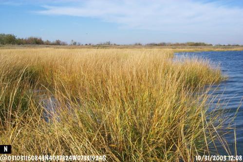
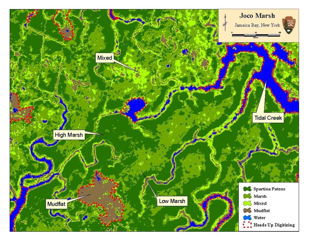
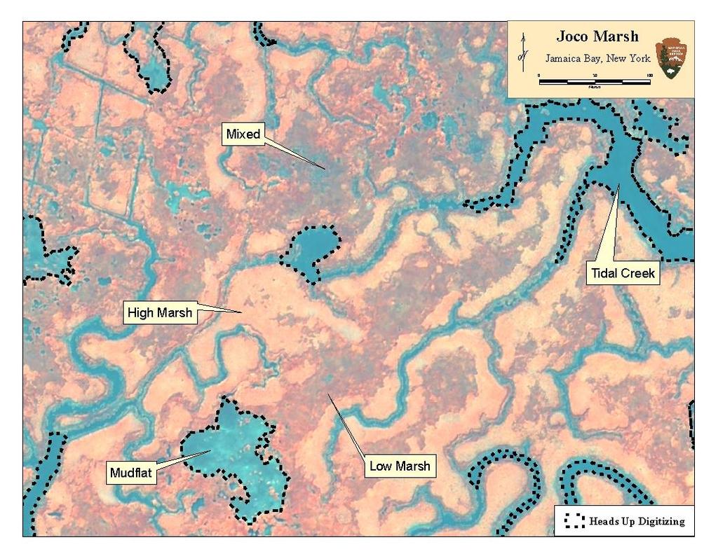
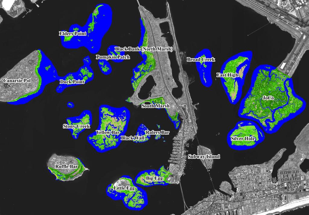
4 An example of salt marsh monitoring, mapping and change analysis Aerial Quick Bird
5 QuickBird-2 September 28, 2003 Band 3,2,1 in RGB)
6 World View II September 19, 2013 Band 4,3,2 in RGB)

7 QuickBird-2 September 28, 2003 Band 4,3,2 in RGB)

8 World View II September 19, 2013 Band 6,3,2 in RGB)

9 QuickBird-2 September 28, 2003 Band 4,3,2 in RGB)

10 World View II September 19, 2013 Band 6,3,2 in RGB)

11 World View-II September 15, 2012 Band 6,3,2 in RGB)

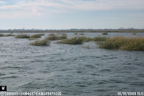
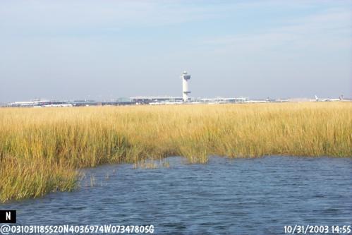
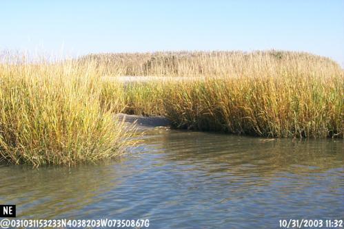
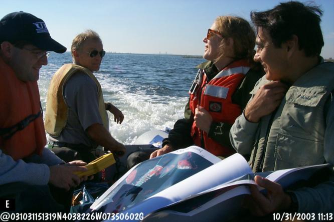
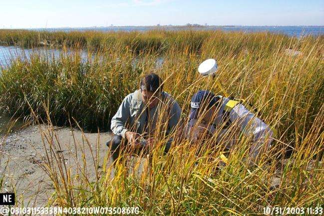
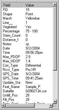
12 Ground Checking Locations
13
14


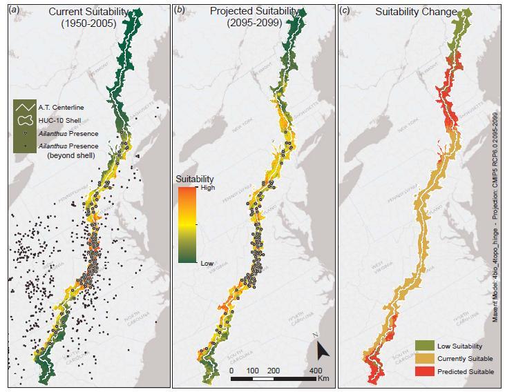
15 A.T. is a cross-section MEGA- Transect of the eastern U.S. Forests and alpine areas, and offers a setting for collecting data on the health of ecosystems for early detection of undesirable changes in the natural resources. Appalachian Trail: 2,175 miles (3,500 km) long and crosses 14 states in the Eastern U.S. Intersecting 8 National Forests; 6 units of the National Park System, More than 70 State Park, Forest, and Game Management units, and 287 local jurisdictions The protected lands harbor rare, threatened, endangered species
16
17 Program Overview This specialization provides students with technical skills required to use state-of-the-art mapping technologies, such as geographic information systems (GIS), and cutting-edge data systems, such as those provided by satellite and aerial remote sensing and global positioning systems (GPS), for the analysis and presentation of environmental data. Students take a core of basic and advanced courses in remote sensing and GIS, where they learn to use modern mapping technologies. Additional coursework provides them with practical instruction in how GIS and remote sensing are applied in environmental analysis and basic research. Students master a large and diverse suite of technical tools in geospatial data analysis. These can be used to solve practical problems, such as in watershed modeling, ecosystem science, wildlife ecology, water resource management, landscape ecology, conservation biology, and land-use and land-cover change (LULCC)
18 Track Requirements Core courses (21-25 credits), including: Natural Sciences (12-16 credits) - Remote Sensing & Spatial Analysis (at least 9 credits) - Earth & Ecosystem Science (0-7 credits) Social Sciences (6 credits) Quantitative Methods (3 credits) Elective courses (6-10 credits) Independent study (Major Paper) (3 credits: EVS 598) Graduate seminar (2 credits)
19 Sample Classes Natural Science Core Courses NRS 415 Remote Sensing of the Environment NRS 509 Concepts in GIS & Remote Sensing NRS 410 Fundamentals of GIS NRS 516 Remote Sensing in Natural Resources Mapping 3 cr. 4 cr. 3 cr. 3 cr. NRS 522 Advanced GIS Analysis of Environmental Data 3 cr. NRS 524 Application of Advanced Spatial Analysis NRS 533 Landscape Pattern and Change 1 cr. 3 cr. Quantitative Methods Courses NRS 520 Quantitative Techniques in Natural Resources Research STA 411 Biostatistics STA 550 Ecological Statistics 3 cr. 3 cr. 3 cr. Social Sciences Courses NRS 555 Applied Coastal Ecology MAF 484 Environmental Analysis & Policy in Coastal Management MAF 527 Marine Protected Areas 2 cr. 3 cr. 3 cr. STA 515 Spatial Data Analysis 3 cr.
20 Internship Opportunities RI Department of Environmental Management RI Natural History Survey Environmental Protection Agency National Park Service US Fish & Wildlife Service The Nature Conservancy
21 Recent Major Paper Topics Name Topic Audience Ann Borowik Landscape Tools for Conservationists: A Custom ESRI ArcToolbox for the Stewardship of Conservation Lands in Rhode Island Michele Georgiani Mapping Inundation From Storm Surge: Modeling the Effects of Hurricane Hazards in Yarmouth, MA Eric Akins Mark Christiano EO-1 Advanced Land Imager Data in Submerged Aquatic Vegetation Mapping A Protocol of Using High Spatial Resolution Satellite Imagery to Map Salt Marshes User groups of conservation and planning Environmental management and disaster control Scientific research and coastal management communities NPS, scientific research and coastal management communities
22 Recent Major Paper Topics Name Topic Audience Marisa Thompson Modeling Sea Level Rise Impacts in South Kingstown Tiffany-Lane Davis Terrain Modeling the Cape Cod National Seashore Thomas Mayo Shelby Southworth Effects of Human Disturbance on Bird Use of a Coastal Barrier Beach: Napatree Point, Rhode Island Rhode Island's Natural Heritage: Locational Discretion in an Age of Spatial Data User groups of conservation and planning NPS, Environmental management and disaster control, scientific research Environmental management and scientific research Land managers, general public
23 Careers Graduates are prepared for careers in federal, state, or municipal government, nonprofit organizations, and private consulting firms requiring professionals who can bring science to bear on policy and management solutions that succeed in a modern political and economic setting.
24 Student Stories Thomas Mayo, Working as GIS Manager, Portsmouth RI, Dept of Public works. Andrew Neill, Research Associate II working as GIS tech for URI EDC on NPS project Shelby Southworth, Working as GIS Analyst at EPA Narragansett Lab. Ann Borowik, GIS Analyst, Town of Wellesly, MA Marisa Thompson, Head of GIS Team, MetLife Insurance Michele Georgiani, Project Manager, Applied Geographics, Inc, Laura Spark, Naval Undersea Warfare Center (NUWC), Newport Eric Akins, US Navy Mark Christiano, GIS Specialist, NPS - Gateway National Recreation Area Christine Slinko, GIS Specialist, private firm Kendall Gadomski, Ph.D. student, international Emily Hale, GIS professional, US Navy

25 Student Stories
MESM Track. Environmental Policy and Management
 MESM Track Environmental Policy and Management Overview This interdisciplinary track prepares students for positions requiring an ability to integrate natural science into policy development and implementation
Joanne N. Halls, PhD Dept. of Geography & Geology David Kirk Information Technology Services
 Joanne N. Halls, PhD Dept. of Geography & Geology David Kirk Information Technology Services Geographic Information Systems manage and analyze data to solve spatial problems. Real World Abstraction Analysis
1. Omit Human and Physical Geography electives (6 credits) 2. Add GEOG 677:Internet GIS (3 credits) 3. Add 3 credits to GEOG 797: Final Project
 2. Add GEOG 677:Internet GIS (3 credits) 3. Add 3 credits to GEOG 797: Final Project") The Department of Geography and the Office of Professional Studies propose to modify the Master of Professional Studies in Geospatial Information Sciences (GIS) as follows: 1. Omit Human and Physical Geography
The Department of Geography and the Office of Professional Studies propose to modify the Master of Professional Studies in Geospatial Information Sciences (GIS) as follows: 1. Omit Human and Physical Geography
GEOGRAPHY (GE) Courses of Instruction
 Courses of Instruction") GEOGRAPHY (GE) GE 102. (3) World Regional Geography. The geographic method of inquiry is used to examine, describe, explain, and analyze the human and physical environments of the major regions of the
GEOGRAPHY (GE) GE 102. (3) World Regional Geography. The geographic method of inquiry is used to examine, describe, explain, and analyze the human and physical environments of the major regions of the
GEOGRAPHY, ENVIRONMENT, AND SUSTAINABILITY (GES)
") Geography, Environment, and Sustainability (GES) 1 GEOGRAPHY, ENVIRONMENT, AND SUSTAINABILITY (GES) GES 102 The Historical Geography of the Western World 3 A study of the geographical factors which combine
Geography, Environment, and Sustainability (GES) 1 GEOGRAPHY, ENVIRONMENT, AND SUSTAINABILITY (GES) GES 102 The Historical Geography of the Western World 3 A study of the geographical factors which combine
Molinaro Keyword: Geography. Associate Professors: Walasek, Ph.D.; (Chair), Wolf, Ph.D.
, Wolf, Ph.D.") 126 - Geography GENERAL INFO GRADUATE UNDREGRADUATE ADULT/NON-TRAD POLICIES STUDENT LIFE ADMISSIONS INTRODUCTION Degree Offered: Bachelor of Arts. Associate Professors: Walasek, Ph.D.; (Chair), Wolf, Ph.D.
126 - Geography GENERAL INFO GRADUATE UNDREGRADUATE ADULT/NON-TRAD POLICIES STUDENT LIFE ADMISSIONS INTRODUCTION Degree Offered: Bachelor of Arts. Associate Professors: Walasek, Ph.D.; (Chair), Wolf, Ph.D.
Pathways. Pathways through the Geography Major
 Pathways through the Major majors may structure their course selections around a sub-field of. Pathways are suggestions for classes in, in related disciplines, and skills training. Each pathway includes
RECOMMENDED STUDY PLAN 2018
 RECOMMENDED STUDY PLAN 208 NAME STUDENT NUMBER DEGREE PROGRAM Graduate Diploma of Science MAJOR Marine Biology (MBY) Level 5: Year SP3 SP SP6/7 SP2 SP0/SP Major Core: Major Skill Core: Major Core: Major
CK107 BA in Geographical and Archaeological Sciences
 CK107 BA in Geographical and Archaeological Sciences CK107 BA in Geographical and Archaeological Science Geography and Archaeology are closely related disciplines, concerned with concepts of time and space
The National Park Service MESM Student Opportunities
 The National Park Service MESM Student Opportunities Sara Stevens Program Manager NPS Programs at URI Northeast Coastal and Barrier Network Monitoring Program (NRS Dept) Sara Stevens, Program Coordinator
GEOGRAPHY (GEOG) Geography (GEOG) 1. GEOG 11. Laboratory in Physical Geography. 1 Unit Prerequisite(s): GEOG 1; may be taken concurrently.
 Geography (GEOG) 1. GEOG 11. Laboratory in Physical Geography. 1 Unit Prerequisite(s): GEOG 1; may be taken concurrently.") Geography (GEOG) 1 GEOGRAPHY (GEOG) GEOG 1. Physical Geography: The Distribution of Natural Phenomena. 3 Units General Education Area/Graduation Requirement: Physical Science (B1), Summer Introductory
Geography (GEOG) 1 GEOGRAPHY (GEOG) GEOG 1. Physical Geography: The Distribution of Natural Phenomena. 3 Units General Education Area/Graduation Requirement: Physical Science (B1), Summer Introductory
Possible MESM Coursework. AFS 415: Fishery Science. AFS 416: Fishery Science Laboratory. AFS 425: Aquaculture and the Environment
 Possible MESM Coursework AFS 415: Fishery Science LEC: (3 crs.) Biology of aquatic resource animals, fisheries mensuration and assessment, fisheries ecology, fishing methods, aquatic resource management
COLLEGE OF PUBLIC AFFAIRS AND COMMUNITY SERVICE School of Public Administration Emergency Services Program Bachelor of Science in Emergency Management
 COLLEGE OF PUBLIC AFFAIRS AND COMMUNITY SERVICE School of Public Administration Emergency Services Program Bachelor of Science in Emergency Management (2015/2016 Catalog) Emergency Management develops
geographic patterns and processes are captured and represented using computer technologies
 Proposed Certificate in Geographic Information Science Department of Geographical and Sustainability Sciences Submitted: November 9, 2016 Geographic information systems (GIS) capture the complex spatial
MASTER OF APPLIED GEOGRAPHY (M.A.GEO.) MAJOR IN GEOGRAPHIC INFORMATION SCIENCE
 MAJOR IN GEOGRAPHIC INFORMATION SCIENCE") Master of Applied Geography (M.A.Geo.) Major in Geographic Information Science 1 MASTER OF APPLIED GEOGRAPHY (M.A.GEO.) MAJOR IN GEOGRAPHIC INFORMATION SCIENCE Major Program The Master of Applied Geography
Master of Applied Geography (M.A.Geo.) Major in Geographic Information Science 1 MASTER OF APPLIED GEOGRAPHY (M.A.GEO.) MAJOR IN GEOGRAPHIC INFORMATION SCIENCE Major Program The Master of Applied Geography
MASTER OF APPLIED GEOGRAPHY (M.A.GEO.) MAJOR IN GEOGRAPHY RESOURCE AND ENVIRONMENTAL STUDIES
 MAJOR IN GEOGRAPHY RESOURCE AND ENVIRONMENTAL STUDIES") Master of Applied Geography (M.A.Geo.) Major in Geography Resource and Environmental Studies 1 MASTER OF APPLIED GEOGRAPHY (M.A.GEO.) MAJOR IN GEOGRAPHY RESOURCE AND ENVIRONMENTAL STUDIES Major Program
Master of Applied Geography (M.A.Geo.) Major in Geography Resource and Environmental Studies 1 MASTER OF APPLIED GEOGRAPHY (M.A.GEO.) MAJOR IN GEOGRAPHY RESOURCE AND ENVIRONMENTAL STUDIES Major Program
RECOMMENDED STUDY PLAN 2018
 RECOMMENDED STUDY PLAN 2018 NAME DEGREE PROGRAM Master of Science STUDENT NUMBER MAJOR Trop Bio & Con-TSV (MSC-TBI) Level 5: Year 1 SP3 SP1 SP6/7 SP2 SP10/SP11 Major Core: BZ5215 Major Opt Skill Conservation
Geography (GEOG) Courses
 Courses") Geography (GEOG) 1 Geography (GEOG) Courses GEOG 100. Introduction to Human Geography. 4 (GE=D4) Introduction to the global patterns and dynamics of such human activities as population growth and movements,
Geography (GEOG) 1 Geography (GEOG) Courses GEOG 100. Introduction to Human Geography. 4 (GE=D4) Introduction to the global patterns and dynamics of such human activities as population growth and movements,
Four specialisations. Cell and System Biology. Evolution and Behaviour. Ecology and Environment
 Master in Biology Four specialisations Cell and System Biology Evolution and Behaviour Ecology and Environment 1 Three professional profiles Research Education Management 2 two years - 120 ECTS points
Application of Geospatial Technology in an Emergency Management Academic Program
 Application of Geospatial Technology in an Emergency Management Academic Program Author Edwin Leachman Visiting Assistant Professor Department of Emergency Administration and Management Arkansas Tech University
Quantifying effects of oil on coastal dune vegetation. Thomas Miller and Elise Gornish Biological Science, Florida State University
 Quantifying effects of oil on coastal dune vegetation Thomas Miller and Elise Gornish Biological Science, Florida State University Natural History of Barrier Islands in the Northern Gulf Make up ~70% of
GEOGRAPHY (GEOG) Geography (GEOG) 1
 Geography (GEOG) 1") Geography (GEOG) 1 GEOGRAPHY (GEOG) GEOG 104 The Physical Environment (4 crs) Introduction to the spatial relations and interactions among the Earth's dynamic systems--atmosphere, biosphere, lithosphere,
Geography (GEOG) 1 GEOGRAPHY (GEOG) GEOG 104 The Physical Environment (4 crs) Introduction to the spatial relations and interactions among the Earth's dynamic systems--atmosphere, biosphere, lithosphere,
ENVS S102 Earth and Environment (Cross-listed as GEOG 102) ENVS S110 Introduction to ArcGIS (Cross-listed as GEOG 110)
 ENVS S110 Introduction to ArcGIS (Cross-listed as GEOG 110)") ENVS S102 Earth and Environment (Cross-listed as GEOG 102) 1. Describe the fundamental workings of the atmospheric, hydrospheric, lithospheric, and oceanic systems of Earth 2. Explain the interactions
ENVS S102 Earth and Environment (Cross-listed as GEOG 102) 1. Describe the fundamental workings of the atmospheric, hydrospheric, lithospheric, and oceanic systems of Earth 2. Explain the interactions
What can I do with a major in Earth Information Science?
 Lewis-Clark State College offers a Bachelor of Arts or Science Degree in Earth Information Science through the Natural Sciences and Mathematics Division. You can learn more about the Natural Sciences and
CHEM 1101 and CHEM 1102 and CHEM 1103 or CHEM 1211 and CHEM 1212 and CHEM CHEM 1214 and CHEM 1215 and CHEM 1216
 Environmental Science, BS 1 Environmental Science, BS Our Bachelor of Science in Environmental Science degree is organized for students who seek a comprehensive understing of the scientific implications
ENVIRONMENT AND NATURAL RESOURCES 3700 Introduction to Spatial Information for Environment and Natural Resources. (2 Credit Hours) Semester Syllabus
 Semester Syllabus") ENVIRONMENT AND NATURAL RESOURCES 3700 Introduction to Spatial Information for Environment and Natural Resources COURSE INSTRUCTOR: Dr. Kris Jaeger Assistant Professor 359 Kottman Hall (Mondays and Tuesdays)
ENVIRONMENT AND NATURAL RESOURCES 3700 Introduction to Spatial Information for Environment and Natural Resources COURSE INSTRUCTOR: Dr. Kris Jaeger Assistant Professor 359 Kottman Hall (Mondays and Tuesdays)
Bachelor of Science in Geography (Fall 2016) Student
 Student") Bachelor of Science in Geography (Fall 2016) Student Student ID# Anticipated Graduation Term Advisor Minimum GPA 2.00 Today's Date 2016-2017 Undergraduate Catalog Requirements System Gen Ed Requirements
Bachelor of Science in Geography (Fall 2016) Student Student ID# Anticipated Graduation Term Advisor Minimum GPA 2.00 Today's Date 2016-2017 Undergraduate Catalog Requirements System Gen Ed Requirements
Grade 11 Student Electives Guidelines for 2015/16
 Grade 11 Student Guidelines for 2015/16 Overview As part of Abu Dhabi Education Council s continuous improvements efforts towards raising the standard of education in the Emirate of Abu Dhabi, the Cycle
Remote Sensing for Ecosystems
 MODULE GUIDE MSc ENR Remote Sensing for Ecosystems Semester 01 Modul coordinator Lecturers Michael Döring Pascal Ochsner, Diego Tonolla, Diane Whited, Michael Döring Martin Geilhausen Latest update August
Diffusion of GIS in Public Policy Doctoral Program
 Diffusion of GIS in Public Policy Doctoral Program By Fulbert Namwamba PhD Southern University This presentation demonstrate how GIS was introduced in the Public Policy Doctoral Program at Southern University,
Michelle Burnett, RI State Floodplain Manager Jess Stimson, RI Floodplain Mapping Coordinator
 The Sandy-est Aftermath: A Rhode Island Perspective After Hurricane Sandy Michelle Burnett, RI State Floodplain Manager Jess Stimson, RI Floodplain Mapping Coordinator June 13, 2013 Rhode Island Background
LEHMAN COLLEGE OF THE CITY UNIVERSITY OF NEW YORK. 1. Type of Change: Change in Degree Requirements
 Alpha Number: Hegis Code 1214 Program Code: 30600 1. Type of Change: Change in Degree Requirements 2. From: [The curriculum consists of 45 graduate credits and includes core courses, an area of specialization,
Current and Future Technology Applications for Coastal Zone Management. Bruce K. Carlisle, Acting Director Office of Coastal Zone Management
 Current and Future Technology Applications for Coastal Zone Management Bruce K. Carlisle, Acting Director Office of Coastal Zone Management The Massachusetts Coastal Zone Management Program Approved in
GEOLOGY & GEOLOGICAL OCEANOGRAPHY
 GEOLOGY & GEOLOGICAL OCEANOGRAPHY Effective Fall 2011 Department: Geosciences, 874-2265, http://www.uri.edu/cels/gel/ UC Advisor: Dr. Anne I. Veeger, veeger@uri.edu, 874-2187 Credits: 120 The Major: This
GEOGRAPHY COURSES UNDERGRADUATE GRADUATE CERTIFICATE FACULTY. Explanation of Course Numbers. Bachelor's program. Minors.
 GEOGRAPHY The Department of Geography is dedicated to achieving excellence in research and education through the diffusion of geographic knowledge that focuses on the relationships between the physical
COURSES OUTSIDE THE JOURNALISM SCHOOL
 COURSES OUTSIDE THE JOURNALISM SCHOOL Students are not limited to the science courses on this list and may select classes from additional specialties. In accordance with University policy, 400-level courses
NOAA Nautical Charts and Coastal and Marine Spatial Planning. Meredith Westington Chief Geographer NOAA/NOS/Office of Coast Survey
 NOAA Nautical Charts and Coastal and Marine Spatial Planning Meredith Westington Chief Geographer NOAA/NOS/Office of Coast Survey Ocean Policy Task Force What is CMSP? A comprehensive, adaptive, integrated,
Ecological mapping using satellite imagery: an Abu Dhabi case study Middle East Geospatial Forum 16 th February 2015
 Ecological mapping using satellite imagery: an Abu Dhabi case study Middle East Geospatial Forum 16 th February 2015 Richard Flemmings rf@proteusgeo.com About Proteus Formed in UAE 2011 We specialise in
Department of Geography
 Department of (College of Social and Behavioral Sciences) www.uni.edu/geography The Department of offers the following undergraduate and graduate programs and program certificate. Specific requirements
GEOGRAPHY (GEOGRPHY) Geography (GEOGRPHY) 1
 Geography (GEOGRPHY) 1") Geography (GEOGRPHY) 1 GEOGRAPHY (GEOGRPHY) GEOGRPHY 1040 Planet Earth 4 Credits The features of the natural environment (lithosphere, atmosphere and hydrosphere); their character, distribution, origin
Geography (GEOGRPHY) 1 GEOGRAPHY (GEOGRPHY) GEOGRPHY 1040 Planet Earth 4 Credits The features of the natural environment (lithosphere, atmosphere and hydrosphere); their character, distribution, origin
Graduate Courses Meteorology / Atmospheric Science UNC Charlotte
 Graduate Courses Meteorology / Atmospheric Science UNC Charlotte In order to inform prospective M.S. Earth Science students as to what graduate-level courses are offered across the broad disciplines of
Introduction to Coastal GIS
 Introduction to Coastal GIS Event was held on Tues, 1/8/13 - Thurs, 1/10/13 Time: 9:00 am to 5:00 pm Location: Roger Williams University, Bristol, RI Audience: The intended audiences for this course are
Overview of Remote Sensing in Natural Resources Mapping
 Overview of Remote Sensing in Natural Resources Mapping What is remote sensing? Why remote sensing? Examples of remote sensing in natural resources mapping Class goals What is Remote Sensing A remote sensing
1. Pass GE1101E Geographical Journeys: Exploring World Environments. This will be counted towards the Faculty Core or UE requirements.
 H Geography At the Department of Geography, students are encouraged to develop a deeper and more critical understanding of both physical and human environments. Students will acquire knowledge, skills
Chapter 1: Introduction to Safety and Ethics
 Core Curriculum Standards Met by Each Chapter On the Right Trail meets Utah s Social Studies Core Curriculum Standards for grades 3-7. Each chapter has specific standard objectives, which are met by the
Geography and Geographic Information Science (Geog)
") University of North Dakota 1 Geography and Geographic Information Science (Geog) http://www.arts-sciences.und.edu/geography Atkinson, Munski (Graduate Director), Niedzielski, Rundquist, Todhunter, Vandeberg
University of North Dakota 1 Geography and Geographic Information Science (Geog) http://www.arts-sciences.und.edu/geography Atkinson, Munski (Graduate Director), Niedzielski, Rundquist, Todhunter, Vandeberg
BACHELOR OF ARTS GEOGRAPHY
 BACHEL OF ARTS General Education Categories (4-5 credits total) FYS First Year Seminar W-I Written Communication - Level I OC Oral Communication PGR Personal Growth & Responsibility CEA Creative Expression
GEOGRAPHIC INFORMATION SYSTEMS AND IT SOLUTIONS FOR THE ENVIRONMENT
 GEOGRAPHIC INFORMATION SYSTEMS AND IT SOLUTIONS FOR THE ENVIRONMENT Mission We focus on Solutions is a worldwide operating business offering Geographic Information Systems and IT solutions to assist environmental
ICAN Great Lakes Workshop
 Washington Coastal latlas ICAN Great Lakes Workshop September 13 15, 15 2010 Current Washington Coastal Atlas http://www.ecy.wa.gov/programs/sea/sma/atlas_home.html 1 st version of WA Coastal Atlas was
Geography (GEOG) Introduction to Geography Global Change and Natural Disasters and Environmental Change
 Introduction to Geography Global Change and Natural Disasters and Environmental Change") Geography (GEOG) Head of Department: Professor Jeffrey P. Osleeb Department Office: Room 422, Philip E. Austin Building For major requirements, see the College of Liberal Arts and Sciences section of this
Geography (GEOG) Head of Department: Professor Jeffrey P. Osleeb Department Office: Room 422, Philip E. Austin Building For major requirements, see the College of Liberal Arts and Sciences section of this
FUTURE COURSES AND CAREERS
 FUTURE COURSES AND CAREERS IN GEOGRAPHY CGC1D Ms. Hyndman PHYSICAL GEOGRAPHY: PATTERNS, PROCESSES AND INTERACTIONS CGF3M Grade 11 course This course examines the major patterns of physical geography and
Welcome to the Department of Biological Sciences. Main Office: Conant Science 301 Mrs. Tracie Fagan Admin. Assistant Phone:
 Welcome to the Department of Biological Sciences Main Office: Conant Science 301 Mrs. Tracie Fagan Admin. Assistant Phone: 508-531-1358 The Department of Biological Sciences Small Classes Excellent New
Advanced Readings. Environment and Land Use Concentration The following seminars and studios would apply
 Community Development and Housing Concentration URP 720 Urban Housing Policies URP 722 Community Development and Housing URP 724 Urban Revitalization Studio URP 726 Citizen Participation Strategies URP
DAVID L. COLVILLE. Education
 DAVID L. COLVILLE Applied Geomatics Research Group (AGRG) Centre of Geographic Sciences (COGS) Annapolis Valley Campus, NSCC Middleton, Nova Scotia, Canada B0S 1P0 Phone: (902) 825 5476 Fax: (902) 825-5479
GEOGRAPHY (GEOG) Geography (GEOG) 1
 Geography (GEOG) 1") Geography (GEOG) 1 GEOGRAPHY (GEOG) GEOG F101X Expedition Earth: Introduction to Geography (s) Introduction to essential concepts and approaches of geographic study. Explores physical, political, economic
Geography (GEOG) 1 GEOGRAPHY (GEOG) GEOG F101X Expedition Earth: Introduction to Geography (s) Introduction to essential concepts and approaches of geographic study. Explores physical, political, economic
Earth / Space Science Major for Secondary Education
 Earth / Space Science Major for Secondary Education FOR EDUCATION COURSES, Please refer carefully to the current Teacher Education Program Guidebook which can be viewed at http://www.calvin.edu/academic/education/programs/guidebook/guidebook.pdf
Ecological Land Cover Classification For a Natural Resources Inventory in the Kansas City Region, USA
 Ecological Land Cover Classification For a Natural Resources Inventory in the Kansas City Region, USA by Applied Ecological Services, Inc. In cooperation with the Mid-America Regional Council 600 Broadway,
PROGRAM MODIFICATION PROGRAM AREA
 CALIFORNIA STATE UNIVERSITY CHANNEL ISLANDS PROGRAM MODIFICATION PROGRAM AREA BIOLOGY Please use the following format to modify any existing program. Any deletions from an existing program need to be underlined
Geography. College of Humanities and Social Sciences 322 GEOGRAPHY
 Geography College of Humanities and Social Sciences INTRODUCTION Geography is the study of the earth as the home of humanity. Geography provides a broad understanding of the processes that unite people,
Curriculum map GEOGRAPHY
 Curriculum map Learning outcomes (LOs): Having completed a major in Geography, a student will be able to: 1. Demonstrate an understanding of the major biophysical and social patterns in the world, and
CAA 1 of 30. To: OAA Date: 6/14/2010. Cover Letter for Proposals from the Department of Geography
 1 of 30 To: OAA Date: 6/14/2010 Cover Letter for Proposals from the Department of Geography This is the transmittal cover letter to the Office of Academic Affairs that reflects the efforts by the Department
Land Use MTRI Documenting Land Use and Land Cover Conditions Synthesis Report
 Colin Brooks, Rick Powell, Laura Bourgeau-Chavez, and Dr. Robert Shuchman Michigan Tech Research Institute (MTRI) Project Introduction Transportation projects require detailed environmental information
Proposal for Revision to the Geographic Information Systems (GIS) Academic Certificate Community College of Philadelphia.
 Academic Certificate Community College of Philadelphia.") Proposal for Revision to the Geographic Information Systems (GIS) Academic Certificate Community College of Philadelphia February 24, 2010 Kathy Smith Chair, Social Science Contributors Christopher Murphy
Proposal for Revision to the Geographic Information Systems (GIS) Academic Certificate Community College of Philadelphia February 24, 2010 Kathy Smith Chair, Social Science Contributors Christopher Murphy
Overview of Methods. Terrestrial areas that are most important for conservation Conservation
 Overview of Methods The goal of the Western Lake Erie Coastal Conservation Vision project (WLECCV) is to define where we should be working locally to optimally achieve regional conservation impact. The
Coastal Barrier Island Network (CBIN): Management strategies for the future
: Management strategies for the future") Coastal Barrier Island Network (CBIN): Management strategies for the future Heather Joesting*, Amy Williams**, Rusty Feagin**, and William K. Smith* *Department of Biology, Wake Forest University, Winston
Coastal Barrier Island Network (CBIN): Management strategies for the future Heather Joesting*, Amy Williams**, Rusty Feagin**, and William K. Smith* *Department of Biology, Wake Forest University, Winston
NOAA s OCM: Services, tools and collaboration opportunities & Puerto Rico s NE Marine Corridor as a case study
 NOAA s OCM: Services, tools and collaboration opportunities & Puerto Rico s NE Marine Corridor as a case study Dr. Antares Ramos Álvarez NOAA s Office of Coastal Management September 15 th, 2016 Conservation
Green Space Services for Local Monitoring
 Green Space Services for Local Monitoring Aratos Group V3.0 2016/08 Value added services for the society using space and satellite technologies Aratos Group 2 One of the first European downstream value
Land Use Methods & Metrics Development Outcome
 Quarterly Progress Meeting November 15, 2018 Land Use Methods & Metrics Development Outcome Peter Claggett, USGS LUWG Coordinator Through the Chesapeake Bay Watershed Agreement, the Chesapeake Bay Program
Strategic Plan for the Geospatial Teaching, Research, and Outreach in CNR. The CNR Geospatial Steering Committee, March 31, 2008
 Strategic Plan for the Geospatial Teaching, Research, and Outreach in CNR The CNR Geospatial Steering Committee, March 31, 2008 Current Mission for the Geospatial Learning Center Established in 1995, the
FORMAT 5 Submit originals and one copy and electronic copy to Governance/Faculty Senate Office ( electronic copy to
 FORMAT 5 Submit originals and one copy and electronic copy to Governance/Faculty Senate Office (email electronic copy to jbharvie@alaska.edu) SUBMITTED BY: PROGRAM/DEGREE REQUIREMENT CHANGE (MAJOR) Department
ESRI NONPROFIT/CONSERVATION GRANTS PROGRAM STATUS REPORT JANUARY 2010
 ESRI NONPROFIT/CONSERVATION GRANTS PROGRAM STATUS REPORT JANUARY 2010 Grantee ESRI Client Number 150983 FARMINGTON RIVER WATERSHED ASSOCIATION 749 Hopmeadow Street, Simsbury, Connecticut 06070 Contact:
Geography General Course Year 12. Selected Unit 3 syllabus content for the. Externally set task 2019
 Geography General Course Year 12 Selected Unit 3 syllabus content for the Externally set task 2019 This document is an extract from the Geography General Course Year 12 syllabus, featuring all of the content
Earth / Space Science Major for Secondary Education
 Earth / Space Science Major for Secondary Education FOR EDUCATION COURSES, Please refer carefully to the current Teacher Education Program Guidebook which can be viewed at http://www.calvin.edu/academic/education/programs/guidebook/guidebook.pdf
Techniques for Science Teachers: Using GIS in Science Classrooms.
 Techniques for Science Teachers: Using GIS in Science Classrooms. After ESRI, 2008 GIS A Geographic Information System A collection of computer hardware, software, and geographic data used together for
LEHMAN COLLEGE CITY UNIVERSITY OF NEW YORK DEPARTMENT OF ENVIRONMENTAL, GEOGRAPHIC, AND GEOLOGICAL SCIENCES CURRICULAR CHANGE
 LEHMAN COLLEGE CITY UNIVERSITY OF NEW YORK DEPARTMENT OF ENVIRONMENTAL, GEOGRAPHIC, AND GEOLOGICAL SCIENCES CURRICULAR CHANGE Hegis Code: 2206.00 Program Code: 452/2682 1. Type of Change: New Course 2.
Department of Biology
 Department of Biology (College of Humanities, Arts and Sciences) www.biology.uni.edu The Department of Biology offers the following undergraduate and graduate programs. Specific requirements for these
Environmental Geography
 nvironmental Geography Master of Science Understanding the interactions between humans and their environment in space and time. Deciphering environmental processes and patterns often requires the bigger
GIS Data and Technology to Support Transportation & MPO Decision-Making & Planning. using an Eco-Logical* Approach within the Kansas City Region
 GIS Data and Technology to Support Transportation & MPO Decision-Making & Planning using an Eco-Logical* Approach within the Kansas City Region Authors (in alphabetical order): Tom Gerend, Tom Jacobs,
Virginia Shoreline Mapping Tools
 Virginia Shoreline Mapping Tools December 15, 2017 Karen Duhring Center for Coastal Resources Management Virginia Institute of Marine Science College of William & Mary Virginia Shoreline Mapping Tools
PROPOSED UNESCO FUNDY BIOSPHERE RESERVE
 OVERVIEW PROPOSED UNESCO FUNDY BIOSPHERE RESERVE NEW BRUNSWICK, CANADA NOMINATION DOCUMENT April 10, 2007 The United Nations Educational, Scientific and Cultural Organization (UNESCO) Man and the Biosphere
The mapping of habitats: an indispensable tool to the planning and management of protected areas in Catalonia
 The mapping of habitats: an indispensable tool to the planning and management of protected areas in Catalonia Palau de Congressos de Catalunya Barcelona, 27 September 2016 Introduction Agoodcartographic
GEOLOGY AND ENVIRONMENTAL GEOSCIENCES (GEOL)
") Bucknell University 1 GEOLOGY AND ENVIRONMENTAL GEOSCIENCES (GEOL) Faculty Professors: Christopher G. Daniel (Chair), Mary Beth Gray, Carl S. Kirby, R. Craig Kochel, Jeffrey M. Trop Associate Professors:
Bucknell University 1 GEOLOGY AND ENVIRONMENTAL GEOSCIENCES (GEOL) Faculty Professors: Christopher G. Daniel (Chair), Mary Beth Gray, Carl S. Kirby, R. Craig Kochel, Jeffrey M. Trop Associate Professors:
Remote Sensing and EO activities at the University of Turku
 Remote Sensing and EO activities at the University of Turku Niina Käyhkö Associate Professor Department of Geography and Geology GEO meeting/syke May 23rd, 2018 Geospatial competence at the University
The B.S.G.E. program is accredited by the Engineering Accreditation Commission of ABET,
 Geomatics Engineering The program of study leading to the Bachelor of Science in Geomatics Engineering (B.S.G.E.) deals with designing solutions to measure, map, model, analyze and graphically display
Summary Visualizations for Coastal Spatial Temporal Dynamics
 Summary Visualizations for Coastal Spatial Temporal Dynamics October 24 2011 Providence, RI Sidharth Thakur 1, Laura Tateosian 2, Helena Mitasova, Eric Hardin, and Margery Overton 1. sthakur@renci.org,
COASTAL DATA APPLICATION
 2015 Coastal GeoTools Proactive By Design. Our Company Commitment COASTAL DATA APPLICATION Projecting Future Coastal Flood Risk for Massachusetts Bay Bin Wang, Tianyi Liu, Daniel Stapleton & Michael Mobile
Introduction to Coastal GIS
 Held on Tues, 1/8/13 through Thurs, 1/10/13 Location: Roger Williams University, Bristol, RI Audience: The intended audiences for this course are federal and state personnel, municipal staff and officials,
This Week s Topics. GIS and Forest Engineering Applications. FE 257. GIS and Forest Engineering Applications. Instructor Information.
 FE 257. GIS and Forest Engineering Applications Introduction Instructor Information Associate Professor in FERM Department Instructor for FE 257, FE 480, FE 432/532 PhD from Forest Resources with minor
Overview. Project Background Project Approach: Content and Application Development Application Demonstration Future Developments
 Overview Project Background Project Approach: Content and Application Development Application Demonstration Future Developments Southeast Pressures: Continued Population Growth Transportation Corridors
Coastal Response Research Center. Nancy Kinner University of New Hampshire (UNH) Michele Jacobi NOAA ORR. September 27, 2007
 Michele Jacobi NOAA ORR. September 27, 2007") Coastal Response Research Center Nancy Kinner University of New Hampshire (UNH) Michele Jacobi NOAA ORR September 27, 2007 1 Coastal Response Research Center (CRRC) CRRC is partnership between NOAA s Office
Coastal Response Research Center Nancy Kinner University of New Hampshire (UNH) Michele Jacobi NOAA ORR September 27, 2007 1 Coastal Response Research Center (CRRC) CRRC is partnership between NOAA s Office
3Chapter Three: Rescue and Response
 17 16 Report Science Title and the Storms: the USGS Response to the Hurricanes of 2005 3Chapter Three: Rescue and Response This chapter documents the U.S. Geological Survey s (USGS) humanitarian rescue
SOUTH DAKOTA BOARD OF REGENTS. Academic and Student Affairs ******************************************************************************
 SOUTH DAKOTA BOARD OF REGENTS Academic and Student Affairs AGENDA ITEM: 7 C (4) DATE: June 28-30, 2016 ****************************************************************************** SUBJECT: New Minor:
Introduction to Geographic Information Systems
 Introduction to Geographic Information Systems What is GIS? GIScience, Geography and Cartography GIS Maps Why is it important? What is Driving GIS? Applications of GIS Case Studies Components of a GIS
MARINE STUDIES (MARINE SPATIAL PLANNING & MANAGEMENT) MASTER S DEGREE
 MASTER S DEGREE") MARINE STUDIES (MARINE SPATIAL PLANNING & MANAGEMENT) MASTER S DEGREE Influence, lead and provide decision making support for the management and planning of coastal and marine spaces. PROGRAM DESCRIPTION
MARINE STUDIES (MARINE SPATIAL PLANNING & MANAGEMENT) MASTER S DEGREE Influence, lead and provide decision making support for the management and planning of coastal and marine spaces. PROGRAM DESCRIPTION
Professional Land Surveyor
 Professional Land Surveyor Professional Land Surveyors establish official land, air space, and water boundaries. They write descriptions of land for deeds, leases, and other legal documents; define air
GIS Geographical Information Systems. GIS Management
 GIS Geographical Information Systems GIS Management Difficulties on establishing a GIS Funding GIS Determining Project Standards Data Gathering Map Development Recruiting GIS Professionals Educating Staff
MARINE STUDIES (MARINE SPATIAL PLANNING & MANAGEMENT) MASTER S DEGREE
 MASTER S DEGREE") MARINE STUDIES (MARINE SPATIAL PLANNING & MANAGEMENT) MASTER S DEGREE Influence, lead and provide decision making support for the management and planning of coastal and marine spaces. PROGRAM DESCRIPTION
MARINE STUDIES (MARINE SPATIAL PLANNING & MANAGEMENT) MASTER S DEGREE Influence, lead and provide decision making support for the management and planning of coastal and marine spaces. PROGRAM DESCRIPTION
Advanced Placement Human Geography
 Advanced Placement Human Geography I. Overview of the Course The purpose of the Advanced Placement (AP) Human Geography course is to introduce students to the systematic study of patterns and processes
Summary Description Municipality of Anchorage. Anchorage Coastal Resource Atlas Project
 Summary Description Municipality of Anchorage Anchorage Coastal Resource Atlas Project By: Thede Tobish, MOA Planner; and Charlie Barnwell, MOA GIS Manager Introduction Local governments often struggle
Presented by: Bryan Bloch GIS Specialist DNREC Division of Watershed Stewardship
 Presented by: Bryan Bloch GIS Specialist DNREC Division of Watershed Stewardship Bryan Hall, AICP Sussex County Circuit Rider Planner, Office of State Planning Coordination, OMB November 19, 2012 UD Sustainable