Community Mapping Network. Selected Coastal Atlases and Information Systems in British Columbia, Canada
|
|
|
- Laura Jenkins
- 6 years ago
- Views:
Transcription

1 Community Mapping Network Selected Coastal Atlases and Information Systems in British Columbia, Canada
2 Outline Community Mapping Network cmnbc.ca Pacific Coastal Resources Atlas for BC cmnbc.ca The Living Atlas (Ecotrust) BC Marine Conservation Analysis Coastal Resource Information System FREMP and BIEAP Program cmnbc.ca Forage Fish cmnbc.ca Eelgrass cmnbc.ca Shorekeepers cmnbc.ca Spartina Invasive species cmnbc.ca Pacific Region Contaminants Atlas cmnbc.ca (not released)

3
4 Pacific Coastal Resources Atlas for British Columbia CMNBC.CA Designed to streamline the collection and dissemination of marine habitat and fishery resource information for coastal BC Opportunistic updates, most layers out of date Community and stewardship information included (identified by metadata) Funding needed to enhance and update New King Tide photo update (Climate change) Use of open layers

5 Pacific Coastal Resources Atlas for British Columbia CMNBC.CA
6 Living Atlas Ecotrust Canada (Clayoquot area) Educational tool for sharing cultural information for community planning A tool to view logging, wildlife populations, temperature and rainfall changes over time Local coastal resource mapping themes Easy access to complex data Multi media stories, photos and videos

7

8 British Columbia Marine Conservation Analysis (bcmca.ca)
9 Bcmca.ca Marine biodiversity and human activity in BC s marine waters Tools help inform ocean management decisions (Marxan modelling) Static maps of species distributions and habitats A richness map of combined ecological data Map showing where data is lacking

10 BCMCA ATLAS study area
11 BC Coastal Resource Information System dss_coastal Presentation last year by Carol Ogborne last year Interactive map for viewing a wide variety of coastal and marine data Updates are ongoing?

12
13 Burrard Inlet Environmental Action Program & Fraser River Estuary Management Plan Atlas CMNBC.ca 20+ inter-governmental partnerships established to coordinate environmental management Key atlas layers Orthophotos of the FREMP area (2002) Habitat Classification (Colour Coding) Habitat Inventory of the Fraser River Estuary,red, yellow and green classification actively updated Shoreline inventory Burrard Inlet 09 Shoreline video

14 Burrard Inlet Environmental Action Program & Fraser River Estuary Management Plan Atlas

15

16
17 Forage Fish Atlas and Data Management System cmnbc.ca Lead by BC Shore Spawners Alliance Map forage fish species and habitat Surf smelt and sand lance Volunteers and Stewardship groups DFO funded Several years of sampling to be uploaded via excel upload tools


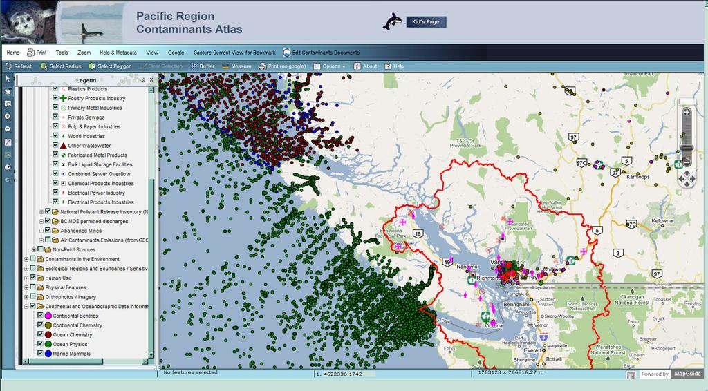
18
19 Eelgrass Bed Atlas and information management system for British Columbia cmnbc.ca Lead by Seachange Society Over 22 coastal communities volunteers and stewardship groups Excel and shapefile upload tools Uses spatial oracle to manage data

20
21 Shorekeepers Monitoring Atlas and information management system Active participation by local people and communities Understanding dynamics of intertidal habitats Monitoring sites are opportunistic Detects change plants and animals due to a nearby activity or industry

22
23 Spartina Invasive Species Mapping and Control cmnbc.ca Drift card program System used to map and manage Spartina Puget Sound information included Submit Spartina data forms via excel

24
25 Pacific Region Contaminants Atlas Fisheries and Oceans Canada, Environment Canada, CMN Interest in take over by EPA and EC Wastewater discharges, point and non point sources (geo-referenced database and document library) Continental Oceanographic Data information System Environmental Resource layers Not officially released yet
26
Designing Networks of Marine Protected Areas in DFO s Three Atlantic Bioregions
 Designing Networks of Marine Protected Areas in DFO s Three Atlantic Bioregions Presentation for Indigenous Protected Areas Workshop Max Westhead, DFO and Adrian Gerhartz-Abraham, Dalhousie March 29, 2017
Mapping on the Edge: shoreline mapping for regulation and voluntary stewardship
 Western Washington University Western CEDAR Salish Sea Ecosystem Conference 2016 Salish Sea Ecosystem Conference (Vancouver, BC) Mapping on the Edge: shoreline mapping for regulation and voluntary stewardship
Introduction: The Gulf of Mexico Alliance. The Gulf GAME project MERMAid and PHINS Results & Conclusions What s next? Examples
 AAG Las Vegas March 25, 2009 Introduction: Ocean governance and Ecosystem-Based Management The Gulf of Mexico Alliance Habitat Identification and Characterization The Gulf GAME project MERMAid and PHINS
Puget Sound Shorelines. Announcements
 Announcements Puget Sound Shorelines Wednesday discussion of Bates paper Bham Bay project: Updates, finals week schedules Last portion of the class: Environmental issues in Puget Sound Puget Sound shorelines:
Cowichan Estuary Habitat Mapping and Oyster Population Assessment. Cowichan Stewardship Round Table
 Cowichan Estuary Habitat Mapping and Oyster Population Assessment Presentation at Cowichan Stewardship Round Table June 21, 2018 By Dr. Goetz Schuerholz 1 More than 8000 drone photos taken stitched together
Management of Spartina anglica in the Fraser River estuary, British Columbia
 Management of Spartina anglica in the Fraser River estuary, British Columbia Gary Williams GL Williams & Associates Ltd. White Rock & Surrey Naturalists Society May 12 th, 2005 White Rock, BC Presentation
Planning for the Shoreline
 Planning for the Shoreline A Summary of the roundtable discussion at Georgia Strait Alliance s second Waterfront Forum June 23, 2014 SFU Harbour Centre Vancouver, BC Planning for the Shoreline Georgia
Presentation Outline. Project Overview. Sea Level Rise Assessment & Decision Tools. Community Engagement. Tina Whitman, Friends of the San Juans
 Healthy Beaches for People & Fish Sea Level Rise Adaptation Tools for San Juan County, WA Tina Whitman & Andrea MacLennan December 10, 2015 Presentation Outline Project Overview Tina Whitman, Friends of
BIOLOGICAL OCEANOGRAPHY
 BIOLOGICAL OCEANOGRAPHY AN INTRODUCTION 0 ^ J ty - y\ 2 S CAROL M. LALLI and TIMOTHY R. PARSONS University of British Columbia, Vancouver, Canada PERGAMON PRESS OXFORD NEW YORK SEOUL TOKYO ABOUT THIS VOLUME
A TOOLKIT FOR MARINE SPATIAL PLANNING Version: 17 July, 2009
 A TOOLKIT FOR MARINE SPATIAL PLANNING Version: 17 July, 2009 NEED FOR MARINE SPATIAL PLANNING The health of marine ecosystems is declining, and use conflicts in the marine environment are increasing, in
Modeling habitat suitability for the European green crab using the ShoreZone mapping system
 Modeling habitat suitability for the European green crab using the ShoreZone mapping system Jodi N. Harney, Ph.D. and John R. Harper, Ph.D. Coastal and Ocean Resources Inc. Mary Morris, R.P. Bio. Archipelago
Marine Ecology Pacing Guide
 Marine Ecology Pacing Guide Course Description: The focus of the course is the interrelationships among marine organisms and the physical, chemical, geological and biological factors. North Carolina coastal
Relatively little hard substrate occurs naturally in the
 CHAPTER FIVE Rock Habitats Relatively little hard substrate occurs naturally in the estuary, owing mainly to the vast quantities of fine sediment that have been deposited by the rivers. Rock habitat is
Gespe gewaq Mi gmaq. Resource Council. Coastal Erosion Awareness. Ugpi ganjig Sitmug Eel River Bar Beach
 Gespe gewaq Mi gmaq Resource Council Coastal Erosion Awareness Ugpi ganjig Sitmug Eel River Bar Beach 2 Table of Contents Introduction...1 Driving Force 1:...2 Sensitivity to Sea-Level Rise Driving Force
53 contributors for 35 individual reports in 2009 show 5% of figures today
 A Group Approach to Understanding Ecosystem Dynamics in the Northeast Pacific Ocean William Crawford and James Irvine, Fisheries and Oceans Canada (DFO) * * * 53 contributors for 35 individual reports
Marine Geomorphology as a Determinant for Essential Life Habitat III
 Marine Geomorphology as a Determinant for Essential Life Habitat III marinecoastalgis.net/aag08 10:10 Dawn Wright, Oregon 10:30 Will McClintock, California 10:50 Daniel Sampson, Massachusetts 11:10 Gary
Microplastics in the marine environment of coastal British Columbia
 Microplastics in the marine environment of coastal British Columbia Jean-Pierre Desforges 1, Moira Galbraith 2, Neil Dangerfield 2, Peter Ross 1 1 School of Earth and Ocean Sciences, University of Victoria,
The Problem. Which ecosystems are the most sensitive? Where will ecosystems be migrating? Where will investments be overwhelmed?
 BC Parks BC Parks is responsible for the designation, management and conservation of a system of ecological reserves, provincial parks and recreation areas located throughout the province. British Columbia
UNIT 5: ECOLOGY Chapter 15: The Biosphere
 CORNELL NOTES Directions: You must create a minimum of 5 questions in this column per page (average). Use these to study your notes and prepare for tests and quizzes. Notes will be stamped after each assigned
How typical are current conditions?
 How typical are current conditions? NANOOS provides many sources of information for those wanting to track oceanographic conditions throughout the NE Pacific Ocean to be able to understand if the current
Nearshore Habitats Why What You do Matters. Landscapes on the Edge November 2016
 Nearshore Habitats Why What You do Matters Landscapes on the Edge November 2016 Primary Topics Focus on marine shorelines ESA species rely on this area Many other fish and wildlife rely on this area The
A Planned Course Statement for. Oceanography. Course # 410 Grade(s) 9, 10, 11, 12. Length of Period (mins.) 40 Total Clock Hours: 60
 9, 10, 11, 12. Length of Period (mins.) 40 Total Clock Hours: 60") East Penn School District Secondary Curriculum A Planned Course Statement for Oceanography Course # 410 Grade(s) 9, 10, 11, 12 Department: Science ength of Period (mins.) 40 Total Clock Hours: 60 Periods
East Penn School District Secondary Curriculum A Planned Course Statement for Oceanography Course # 410 Grade(s) 9, 10, 11, 12 Department: Science ength of Period (mins.) 40 Total Clock Hours: 60 Periods
ICAN Great Lakes Workshop
 Washington Coastal latlas ICAN Great Lakes Workshop September 13 15, 15 2010 Current Washington Coastal Atlas http://www.ecy.wa.gov/programs/sea/sma/atlas_home.html 1 st version of WA Coastal Atlas was
Ocean circulation, sedimentation in the San Juans - compilation of mainstream scientific literature by Dave Hyde -
 Ocean circulation, sedimentation in the San Juans - compilation of mainstream scientific literature by Dave Hyde - Salish Sea has 3 principal estuaries SG, JDF,PS San Juan Islands ocean setting uniquely
Coastal Response Research Center. Nancy Kinner University of New Hampshire (UNH) Michele Jacobi NOAA ORR. September 27, 2007
 Michele Jacobi NOAA ORR. September 27, 2007") Coastal Response Research Center Nancy Kinner University of New Hampshire (UNH) Michele Jacobi NOAA ORR September 27, 2007 1 Coastal Response Research Center (CRRC) CRRC is partnership between NOAA s Office
Coastal Response Research Center Nancy Kinner University of New Hampshire (UNH) Michele Jacobi NOAA ORR September 27, 2007 1 Coastal Response Research Center (CRRC) CRRC is partnership between NOAA s Office
Data Dictionary Hudson River Features: Estuary shoreline Flood scenario Emergency Services: Police stations Fire stations EMS
 Data Dictionary Hudson River Features: Estuary shoreline This data layer represents the border of the Hudson River in our study area. New York State Department of Environmental Conservation. 2009. Hudson
SUMMARY REPORT SHARING NATURAL RESOURCE INFORMATION
 Community Mapping Network SUMMARY REPORT SHARING NATURAL RESOURCE INFORMATION Community Mapping Network Summary Report Table of Contents WHY THIS DOCUMENT?...ERROR! BOOKMARK NOT DEFINED. AN INTRODUCTION
A Geographic Information System Based Model John L Marshall Geography 562 GIS Coastal Resources - Final Project: Fall 2017 University of Washington
 EFFECTS OF OYSTER CULTURE ON NATIVE EELGRASS AND RELATED NATURAL RESOURCES IN THE PUGET SOUND A Geographic Information System Based Model John L Marshall Geography 562 GIS Coastal Resources - Final Project:
Sea Level Rise Providing Nature A-Right-of Way
 Sea Level Rise Providing Nature A-Right-of Way Study Area Site 2: Skagit Bay Initial Condition 11.2 Inches by 2050 No Dikes 27.3 Inches by 2100 No Dikes The Problem Loss of coastal wetlands due to submergence
Bob Van Dolah. Marine Resources Research Institute South Carolina Department of Natural Resources
 Bob Van Dolah Marine Resources Research Institute South Carolina Department of Natural Resources Shoreline Change Will Occur! On our front beaches where it is not easy to retreat Shoreline Change Will
Alaska ShoreZone Coastal Habitat Mapping Program
 Alaska ShoreZone Coastal Habitat Mapping Program Auke Bay Laboratories Alaska Fisheries Science Center Mandy Lindeberg Coastal Issues in Alaska Resource development Coastal development Climate change Loss
Environmental Response Management Application
 Environmental Response Management Application Coastal Response Research Center Nancy Kinner, Michele Jacobi, Rob Braswell, Kurt Schwehr & Amy Merten RRT III May 14, 2008 1 Talk Outline Overview of Center
Liana Talaue McManus. Division of Marine Affairs and Policy Rosenstiel School of Marine & Atmospheric Science University of Miami
 Liana Talaue McManus Division of Marine Affairs and Policy Rosenstiel School of Marine & Atmospheric Science University of Miami Outline 1. Coasts as vulnerable & resilient social ecological systems 2.
NORTH VANCOUVER ISLAND MARINE PLAN: OVERVIEW 2015
 NORTH VANCOUVER ISLAND MARINE PLAN: OVERVIEW 2015 North Vancouver Island Marine Plan Overview Refers to: Marine Planning Partnership Initiative. 2015. North Vancouver Island Marine Plan. Copyright 2015
Multi-sector biodiversity surveys: integrating federal, territorial and community-based surveys. Kevin J. Hedges
 Multi-sector biodiversity surveys: integrating federal, territorial and community-based surveys Kevin J. Hedges Outline Study area Research/stakeholder groups Recent integration Eastern Canadian Arctic
Introducing the. a partnership of
 Introducing the a partnership of Background Need for online atlas identified by managers and researchers to make coastal data available Shoreline data Ocean and coastal resources Sea-level rise potential
THE DIGITAL TERRAIN MAP LIBRARY: AN EXPLORATIONIST S RESOURCE
 THE DIGITAL TERRAIN MAP LIBRARY: AN EXPLORATIONIST S RESOURCE By I.C.L. Webster, P.J. Desjardins and W.E. Kilby KEYWORDS: digital terrain maps, digital terrain stability maps, surficial geology, GIS, raster
Alexandra Carvalho, Ph.D., GISP Kathy Fitzpatrick, P.E.
 Coastal Data Organization for Project Management and Coastal Planning Martin County, Florida Alexandra Carvalho, Ph.D., GISP Kathy Fitzpatrick, P.E. Outline County Coastal Programs Coastal Geodatabase
T aanu Telegram. SCWG is in its Third Year! Eelgrass Festival Plans Underway. Issue No.3 December 2004
 T aanu Telegram A NEWSLETTER ABOUT EELGRASS CONSERVATION IN BRITISH COLUMBIA Issue No.3 December 2004 T aanu is Haida for eelgrass The Seagrass Conservation Working Group (SCWG) has been working to conserve
Bighouse = Centre of Traditional Governance 7/18/2011. No Permission Required: Walking the Talk in First Nation Natural Resources Stewardship
 No Permission Required: Walking the Talk in First Nation Natural Resources Stewardship Doug Aberley and Brian Wadhams People in Places Conference / June 28, 2011 / Halifax NS First Nation 1,700 members
Marine Biodiversity: Global Ocean to the Salish Sea Design Your Own Salish Sea Creature
 Science Unit: Lesson #2 Marine Biodiversity: Global Ocean to the Salish Sea Design Your Own Salish Sea Creature Summary: Lesson type: Grade level: Duration of lesson: Developed by: Developed for: Based
A Comparison of the Anomalous Ocean Conditions observed off the West Coast of Canada in 2014 and 2015.
 A Comparison of the Anomalous Ocean Conditions observed off the West Coast of Canada in 2014 and 2015. Peter Chandler, Marie Robert, Moira Galbraith Institute of Ocean Sciences, Fisheries and Oceans Canada,
Treasure Coast Science Scope and Sequence
 Course: Marine Science I Honors Course Code: 2002510 Quarter: 3 Topic(s) of Study: Marine Organisms and Ecosystems Bodies of Knowledge: Nature of Science and Life Science Standard(s): 1: The Practice of
DFO Maritimes Region Update. Gulf of Maine Council - Coastal and Marine Spatial Planning (CMSP) Committee Web-Ex May 16, 2017
 Committee Web-Ex May 16, 2017") DFO Maritimes Region Update Gulf of Maine Council - Coastal and Marine Spatial Planning (CMSP) Committee Web-Ex May 16, 2017 1 National Oceans Priorities Marine Conservation Targets Oceans Protection Plan
DFO Maritimes Region Update Gulf of Maine Council - Coastal and Marine Spatial Planning (CMSP) Committee Web-Ex May 16, 2017 1 National Oceans Priorities Marine Conservation Targets Oceans Protection Plan
Landforms. Lesson 1: Physical Geography of Canada Mexico. Canada s mountainous eastern and western edges create a central region of fertile plains.
 Lesson 1: Physical Geography of Canada Mexico Landforms Canada s mountainous eastern and western edges create a central region of fertile plains. Collisions of tectonic plates thrust up a series of sharp-peaked
National Wetlands Inventory Update for New England 2009
 National Wetlands Inventory Update for New England 2009 Ralph Tiner Wetland Ecologist U.S. Fish & Wildlife Service National Wetlands Inventory Program Where we ve been Maps Status and trends investigations
12/2/15. Providing observa.ons, data and informa.on products to meet agency and stakeholder needs
 12/2/15 Providing observa.ons, data and informa.on products to meet agency and stakeholder needs 1 Part of the Integrated Ocean Observing System (IOOS) Governed through a Memorandum of Agreement Fiscal
Moreton Bay and Key Geographic Concepts Worksheet
 Moreton Bay and Key Geographic Concepts Worksheet The Australian Curriculum: Geography draws on seven key geographic concepts: place scale space environment change interconnection sustainability They are
Port of Kalama, 2013 TEMCO Berth Maintenance Dredging and In-water Flow-Lane Placement Project
 2014 WEDA ENVIRONMENTAL EXCELLENCE AWARDS Category: Navigation Dredging Port of Kalama, 2013 TEMCO Berth Maintenance Dredging and In-water Flow-Lane Placement Project Port of Kalama, Washington 18 April
Introduction. Methods. Keyword: Bulkhead, Armoring, Thurston County, SRFB, Forage Fish
 Bulkheading in Thurston County: Impacts on Forage Fish Spawning Habitat José Carrasquero-Verde (jcarrasquero@herrerainc.com), Tim Abbe (tabbe@herrerainc.com), Herrera Environmental Consultants Steven Morrison
The IHPT Marine Spatial Data infrastructure and its contribution to the INSPIRE Directive
 The IHPT Marine Spatial Data infrastructure and its contribution to the INSPIRE Directive INSPIRE - GWF 2015 - Coastal & Marine session Lisbon Congress Center, Portugal - Thursday, 28 May 2015 Summary
This material is contributed by David Giblin. It is a great introduction about the UW herbarium research, but contents of this presentation will be
 This material is contributed by David Giblin. It is a great introduction about the UW herbarium research, but contents of this presentation will be on the lecture exam. Floristics Research at the University
OCEAN ZONES. 1. Intertidal Zone 2. Near-Shore Zone 3. Open-Ocean Zone
 OCEAN ZONES 1. Intertidal Zone 2. Near-Shore Zone 3. Open-Ocean Zone Where the Ocean Meets the Land (Place) Intertidal Zone The intertidal zone is the area between the high- and low-tide lines. At high
OCEAN ZONES. 1. Intertidal Zone 2. Near-Shore Zone 3. Open-Ocean Zone
 OCEAN ZONES 1. Intertidal Zone 2. Near-Shore Zone 3. Open-Ocean Zone Where the Ocean Meets the Land (Place) Intertidal Zone The intertidal zone is the area between the high- and low-tide lines. At high
Spatial Decision-Support for National Marine Conservation Areas in the Southern Strait of Georgia and Gwaii Haanas
 Spatial Decision-Support for National Marine Conservation Areas in the Southern Strait of Georgia and Gwaii Haanas Lindsay McBlane Krista Royle Greg MacMillan Photo: Mark Hiebert Western and Northern Service
Your web browser (Safari 7) is out of date. For more security, comfort and. the best experience on this site: Update your browser Ignore
 is out of date. For more security, comfort and. the best experience on this site: Update your browser Ignore") Your web browser (Safari 7) is out of date. For more security, comfort and Activitydevelop the best experience on this site: Update your browser Ignore Rescuing, Relocating, and Rehabilitating Wildlife
Your web browser (Safari 7) is out of date. For more security, comfort and Activitydevelop the best experience on this site: Update your browser Ignore Rescuing, Relocating, and Rehabilitating Wildlife
Margarita Stancheva Hristo Stanchev & Robert Young 2. MEDCOAST JUBILEE WORKSHOP May 2015, Iberotel Sarigerme Park, Dalaman, Turkey
 Margarita Stancheva Hristo Stanchev & Robert Young 2 INTRODUCTION: Bulgarian Black Sea coast INTRODUCTION: Increasing pressure on Bulgarian coastal zone In 2011, of the 7 364 570 people that lived in Bulgaria,
PROBABILITY-BASED ESTIMATION OF NEARSHORE HABITAT CHARACTERISTICS
 In: Proceedings of Puget Research '98 Conference, Seattle, WA. PROBABILITY-BASED ESTIMATION OF NEARSHORE HABITAT CHARACTERISTICS Allison Bailey, Helen Berry, Betty Bookheim Washington State Department
African Coastal Atlas developments. 10 July 2008 EEA Copenhagen, Denmark
 African Coastal Atlas developments 10 July 2008 EEA Copenhagen, Denmark Africa Overview Africa has approximately 40 000 km of coast across 32 mainland countries and four island states. Africa's coastal
Weather Extremes in Canada: Understanding the Sources and Dangers of Weather
 Weather Extremes in Canada: Understanding the Sources and Dangers of Weather Lesson Overview This lesson will focus on the extremes of weather and how they affect Canada. Important meteorological factors
OCEANOGRAPHIC DATA MANAGEMENT
 OCEANOGRAPHIC DATA MANAGEMENT Presented to: Environmental Disaster Data Management Meeting Russ Beard Director, National Coastal Data Development Center Interim Science Coordinator, Gulf Restoration Council
The role of reproductive timing as a driver of genetic differentiation in populations of Pacific herring
 Western Washington University Western CEDAR Salish Sea Ecosystem Conference 2018 Salish Sea Ecosystem Conference (Seattle, Wash.) Apr 6th, 2:30 PM - 2:45 PM The role of reproductive timing as a driver
A Comparison of Predicted Along-channel Eulerian Flows at Cross- Channel Transects from an EFDC-based Model to ADCP Data in South Puget Sound
 A Comparison of Predicted Along-channel Eulerian Flows at Cross- Channel Transects from an EFDC-based Model to ADCP Data in South Puget Sound Skip Albertson, J. A. Newton and N. Larson Washington State
Restoring Rivers in Cumbria Online Story Map of a case study on the River Lyvennet
 Restoring Rivers in Cumbria Online Story Map of a case study on the River Lyvennet Summary This Story Map presents a river restoration case study for the River Eden Catchment, Cumbria. Students can learn
Science 8 Unit 1 Test Review Analyze factors that affect productivity and species distribution in marine and fresh water environments.
 Science 8 Unit 1 Test Review How does water shape our world? 1. Define a water system in your own words 2. What is water important for? (3 things at least) 3. What is water made of? Water in our world
THE USE OF GEOSPATIAL DATA TO SUPPORT VULNERABILITY MAPPING OF THE OREGON COAST. Kelvin Raiford MS Candidate Geography Department of Geosciences
 THE USE OF GEOSPATIAL DATA TO SUPPORT VULNERABILITY MAPPING OF THE OREGON COAST Kelvin Raiford MS Candidate Geography Department of Geosciences INTRODUCTION This study is an outcome of the project Geospatial
3 SHORELINE CLASSIFICATION METHODOLOGY
 3 SHORELINE CLASSIFICATION METHODOLOGY Introduction The ESI scale, as described in Section 2, categorizes coastal habitats in terms of their susceptibility to spilled oil, taking into consideration a number
Water Atlas Overview. Myakka River Management Coordinating Council June 22, 2012 Englewood, Florida
 Water Atlas Overview Myakka River Management Coordinating Council June 22, 2012 Englewood, Florida What is the Water Atlas? A data warehouse A set of interactive maps A collection of tools for viewing/analyzing
Atlas of Living Scotland New data infrastructure for research and citizen science
 Atlas of Living Scotland New data infrastructure for research and citizen science John Sawyer and Rachel Stroud CEO NBN Trust, j.sawyer@nbn.org.uk Who is the National Biodiversty Network? The National
Sea-level Rise on Cape Cod: How Vulnerable Are We? Rob Thieler U.S. Geological Survey Woods Hole, MA
 Sea-level Rise on Cape Cod: How Vulnerable Are We? Rob Thieler U.S. Geological Survey Woods Hole, MA Outline Sea-level and coastal processes Past sea-level change Predictions for the future Coastal responses
Assessing, Monitoring, and Defending Coral Reefs with GIS
 Assessing, Monitoring, and Defending Coral Reefs with GIS Dr. Rich Snow and Dr. Mary Snow Applied Aviation Sciences Embry-Riddle Aeronautical University Daytona Beach, Florida It is estimated that 60%
Flood Risk Mapping and Forecasting in England
 Flood Risk Mapping and Forecasting in England Mark Franklin Environment Agency, England NORDESS Workshop on Risk Assessment and Acceptable Risk Outline Flood risk in England Who we are and how we work
BIOMES. Copyright Cmassengale
 BIOMES Continental drift - slow motion of continents Dispersal of organisms Movement of organisms from 1 place to another Dispersal is usually caused by wind, water or living things Species that evolve
Vancouver Island Spartina Eradication Program 2012 Progress Report
 Vancouver Island Spartina Eradication Program 2012 Progress Report Submitted By: Alison Millham, Coastal Invasive Plant Committee and Steven Godfrey, Vancouver Island Conservation Lands Management Program
GIS 2010: Coastal Erosion in Mississippi Delta
 1) Introduction Problem overview To what extent do large storm events play in coastal erosion rates, and what is the rate at which coastal erosion is occurring in sediment starved portions of the Mississippi
Mussel Powered Living Shorelines for Salt Marsh Erosion Control
 Mussel Powered Living Shorelines for Salt Marsh Erosion Control Laura Whalen Danielle Kreeger David Bushek Angela Padeletti Josh Moody Partnership for the Delaware Estuary Haskin Shellfish Research Lab
ssessments Ecoregional Assessment
 Standard 7: Select terrestrial, freshwater and marine conservation targets/biodiversity elements/features across multiple biological and spatial scales. Case Study: Shoreline Habitat Classification for
Measuring ecosystems and biodiversity and related goods and services
 Measuring ecosystems and biodiversity and related goods and services World Bank, WAVES Partnership Meeting Michael Bordt, EASD Statistics Canada March 30, 2011 Outline What exists already in Canada and
APPENDIX A. Study Team Member Profiles
 APPENDIX A Study Team Member Profiles APPENDIX A Eugene Lee, M.Sc. 28) was an AMEC Senior environmental/aquatic biologist/project manager with 23 years consulting experience. Mr. Lee has extensive experience
Using Remote Sensing to Map the Evolution of Marsh Vegetation in the South Bay of San Francisco
 Using Remote Sensing to Map the Evolution of Marsh Vegetation in the South Bay of San Francisco Brian Fulfrost Design, Community and Environment (DC&E) 6 th Annual Bay-Delta Science Conference PROJECT
The Atlas Aspect of the Atlas of Living Australia
 The Atlas Aspect of the Atlas of Living Australia Lee Belbin lee@blatantfabrications.com Melbourne Museum, July 28, 2010 The Atlas is funded by the Australian Government under the National Collaborative
Create your own map for tidepooling, beach field trips, boating, camping, kayaking, fishing, and exploring the beaches in Southcentral Alaska.
 Create your own map for tidepooling, beach field trips, boating, camping, kayaking, fishing, and exploring the beaches in Southcentral Alaska. Here s an opportunity to download and customize your own free
Strategies for Control of Giant Salvinia and Other Invasive Species
 Strategies for Control of Giant Salvinia and Other Invasive Species Projects under consideration for a Caddo Lake Institute grant proposal to the National Fish & Wildlife Foundation Initial Focus is on
Mapping of Future Coastal Hazards. for Southern California. January 7th, David Revell, Ph.D. E.
 Mapping of Future Coastal Hazards for Southern California January 7th, 2014 David Revell, Ph.D. drevell@esassoc.com E. Vandebroek, 2012 Outline Coastal erosion hazard zones Flood hazard zones: Coastal
Regional-scale understanding of the geologic character and sand resources of the Atlantic inner continental shelf, Maine to Virginia
 Regional-scale understanding of the geologic character and sand resources of the Atlantic inner continental shelf, Maine to Virginia Workshop on Dredging, Beach Nourishment and Bird Conservation Atlantic
Marine Spatial Planning: A Tool for Implementing Ecosystem-Based Management
 Marine Spatial Planning: A Tool for Implementing Ecosystem-Based Management Steven Murawski, Ph.D., Ecosystem Goal Team Lead National Oceanic and Atmospheric Administration NOAA November 16, 2009 1 To
BOEM Marine Minerals Program
 BOEM Marine Minerals Program Restoring and Protecting Our Nation s Coasts through Stewardship of OCS Sand Resources SECOORA 2018 Annual Meeting May 22-24 Doug Piatkowski Douglas.piatkowski@boem.gov 703-787-1833
Soft Shore Protection As An Alternative To Bulkheads - Projects And Monitoring
 Soft Shore Protection As An Alternative To Bulkheads - Projects And Monitoring Jim W. Johannessen Coastal Geologic Services, Inc. Introduction Beach erosion and improper development along the shore have
Integrating ARCGIS with Datamining Software to Predict Habitat for Red Sea Urchins on the Coast of British Columbia.
 Integrating ARCGIS with Datamining Software to Predict Habitat for Red Sea Urchins on the Coast of British Columbia. Wayne Hajas Pacific Biological Station Nanaimo, BC 1 Allison Smeaton GIS-student intern
Armoring on Puget Sound: Progress towards a better baseline
 Western Washington University Western CEDAR Salish Sea Ecosystem Conference 2016 Salish Sea Ecosystem Conference (Vancouver, BC) Armoring on Puget Sound: Progress towards a better baseline Hugh Shipman
Geospatial Decision Support Tools for Planning of Marine Protected Areas in California
 Geospatial Decision Support Tools for Planning of Marine Protected Areas in California WILL MCCLINTOCK (UNIVERSITY OF CALIFORNIA SANTA BARBARA), MATT MERRIFIELD (THE NATURE CONSERVANCY), SOPHIE DE BEUKELAER
Spatial variation in the abundance of eelgrass (Zostera marina) at eight sites in western Newfoundland, Canada 5/5/2015 V2.0
 at eight sites in western Newfoundland, Canada 5/5/2015 V2.0") Spatial variation in the abundance of eelgrass (Zostera marina) at eight sites in western Newfoundland, Canada 5/5/2015 V2.0 1 Summary The abundance of eelgrass (Zostera marina) was quantified at eight
Spatial variation in the abundance of eelgrass (Zostera marina) at eight sites in western Newfoundland, Canada 5/5/2015 V2.0 1 Summary The abundance of eelgrass (Zostera marina) was quantified at eight
Coastal and Marine Ecological Classification Standard (CMECS)
") Coastal and Marine Ecological Classification Standard (CMECS) Kathy Goodin, NatureServe EMECS, August 2011 Baltimore, MD 1 Outline Objectives & Process Classification Content Questions 2 Objectives Develop
Coastal and Marine Ecological Classification Standard (CMECS) Kathy Goodin, NatureServe EMECS, August 2011 Baltimore, MD 1 Outline Objectives & Process Classification Content Questions 2 Objectives Develop
Using Big Interagency Databases to Identify Climate Refugia for Idaho s Species of Concern
 Using Big Interagency Databases to Identify Climate Refugia for Idaho s Species of Concern What is a Climate Refugia? habitat that supports a locally reproducing population [or key life history stage]
Mapping tidal wetlands and their losses on the U.S. West Coast: new methods, new insights
 Mapping tidal wetlands and their losses on the U.S. West Coast: new methods, new insights Assoc. of State Wetland Managers Members Webinar January 31, 2018 Presented by: Laura Brophy Director, Estuary
THE SEVILLE STRATEGY ON BIOSPHERE RESERVES
 THE SEVILLE STRATEGY ON BIOSPHERE RESERVES 1 VISION FOR BIOSPHERE RESERVES IN THE 21 ST CENTURY The international Seville Conference on Biosphere Reserves, organised by UNESCO, adopted a two-pronged approach,
Introduction to Acoustic Remote Sensing and Seafloor Mapping (AE4-E13) May 19, 2010
 May 19, 2010") Introduction to Acoustic Remote Sensing and Seafloor Mapping (AE4-E13) May 19, 2010 1 Delft Vermelding Institute onderdeel of Earth organisatie Observation and Space Systems Why Acoustic Remote Sensing?
Introduction to Acoustic Remote Sensing and Seafloor Mapping (AE4-E13) May 19, 2010 1 Delft Vermelding Institute onderdeel of Earth organisatie Observation and Space Systems Why Acoustic Remote Sensing?
British Columbia Spartina Eradication Program 2009 Progress Report
 British Columbia Spartina Eradication Program 2009 Progress Report Prepared by: Ducks Unlimited Canada (February 2010) Contact: Claire de la Salle Address: 511 13370 78 th Ave Surrey BC V3W 0H6 Phone:
University of New Hampshire Scholars' Repository
 University of New Hampshire University of New Hampshire Scholars' Repository Center for Coastal and Ocean Mapping Center for Coastal and Ocean Mapping 3-2009 Environmental Response Management Application
Mapping Predicted Tidal Exposure Durations Using a MLLW-Referenced LiDAR Terrain Model
 Mapping Predicted Tidal Exposure Durations Using a MLLW-Referenced LiDAR Terrain Model for Management of Spartina alterniflora in Willapa Bay, Washington Meeting the Challenge: Invasive Plants in PNW Ecosystems